GEOGRAPHIC INFORMATION SYSTEM (GES203)
|
|
|
- Norma Knight
- 5 years ago
- Views:
Transcription
1 GEOGRAPHIC INFORMATION SYSTEM (GES203) GIS Components Level 2:1 By: Mrs Mupfiga
2 Presentation Layout Recap Learning Objectives Components of GIS GIS Data References Lecture Evaluation
3 Learning Objectives To identify the 5 basic components of a GIS To describe the basic components of a GIS To describe geographic data To identify the sources of geographic data To describe the GIS Cycle
4 Recap What is so special about GIS? Where can GIS be applied?
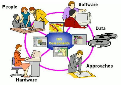
5 GIS Components
6 People People are the most important part of a GIS because they define and develop the procedures used by a GIS GIS technology is of limited value without the people who manage the system and develop plans for applying it to real-world problems. Ground truth data collection Data storing, processing and analysis GIS users range from technical specialists, who design and maintain the system to those who use it to help them perform their everyday work.
7 Approaches / Methods/ Organizational protocols. A successful GIS operates according to a well-designed plan and business rules, which are the models and operating practices unique to each organization
8 Hardware Hardware is the physical components on which a GIS operates CPU Monitor Digitizing table Scanners Printers What are the hardware specifications for GIS?
9 Hardware GIS can be run on a wide range of hardware types, from centralized computer servers to desktop computers used in stand-alone or networked configurations. A fast computer, large data storage capacities, and a highquality display. A fast computer is required because spatial analyses are often applied over large areas and/or at high spatial resolutions and calculations often have to be repeated over tens of millions of times, In GIS large volumes of data must be entered to define the shape and location of geographic features, such as roads, rivers.
10 Hardware For presentations, a printer and a projector are needed Digitizing tables and scanners are needed to convert analogue map data and tables to digital databases It is important to adapt the investments in hardware to the needs of the organisation. All system components need to be connected in a Local Area Network (LAN) if maximum efficiency should be reached in a complex organisation.
11 Software GIS software provides the tools to capture, manage, analyze, and effectively display spatial data and spatial information. There are many public domain and commercially available GIS software packages, Many of these packages originated at academic or government-funded research laboratories. List the GIS software that you know. The GIS software often represents a considerable share of the investment costs when introducing GIS in an organisation.
12 Software It is important to consider the needs, the user category and the functionality, since it is rather useless to provide a person with very limited knowledge in GIS an advanced software and vice versa. Thus to optimize the investment software must be adapted to the activities of users in the organization Another important issue to consider when selecting software is the possibilities to get technical support from national suppliers rather that being dependent on support from organizations overseas.
13 Software Examples of the major or widely used software packages are ArcGIS, ERDAS (Earth Resources Data Analysis System, used for Remote sensing image processing e.g is ERDAS IMAGINE 9.1), ILWIS(mostly used for hydrological modelling), QGIS Grass (Geographic Resource Analysis Support System), Mapmaker

14 Data Is the fuel of the GIS. Data can be collected inhouse or purchased from a commercial data provider. This means that the information must be from a reliable source. It must be accurate record of reality. The suppliers of data must have a reliable rate of supply.
15 Data Data must carry with it quality statements about how the data was collected, by whom and when etc. this information guaranties / verifies the quality of the data. Data must be relevant for the purpose for which it must be used. It must be the correct type of data. Data must be accessible. This is a big issue in most developing countries.

16 Data No matter how sophisticated a GIS may be, it cannot change the fact that the system is never better than its weakest link. If a GIS is fed by garbage data, the output from analysis and other operations will also be garbage
17 Video Components of GIS
18 GEOGRAPHIC DATA
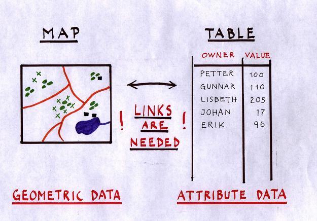
19 What is geographic data? Data that can be allocated a location, It is necessary to define what geographical data is, since GIS operates by using this type of data. Geographic data includes all things on the earth s surface. Geographic data = Geometric data + Non Spatial data (attributes/properties) Geometric data: gives the location data and spatial extent (shape) of map objects. Attribute data: represents some property that describes the map objects.

20 Almost all objects in our surroundings can be connected to a specific location and are possible to handle in a GIS.

21 Geographic Data describe

22 Geometric data Location is given by using a coordinate system.
23 Non spatial data: Attribute data Attribute data is the non-spatial data about a geometric object Attributes describe the characteristics of the map objects and are linked to these objects in the GIS Examples?? Object Road Attribute Road No. ; Surface type, Width, House Owner, Address, No of rooms Administration district Name of District, Population
24 Geographic Data
25 Demonstration Hardware Software Geometric Data Attribute Data
26 Homework: Attribute Data Types Describe giving specific examples, the following attribute data types: Nominal Ordinal Interval Ratio [15]
27 Metadata Information about data Acts as quality statement. It assures a certain level of quality, reliability and flexibility for the users of the database Description of the source of data and the database development process information about where the data was retrieved from and how it has been processed before entering the database. Attribute accuracy Is the attribute an actual measurement, estimation or interpolation of attribute values.
28 Metadata Date(s) of data collection and interval of updating the data. - It is important as it informs the user about future extensions of the database. Some databases, e.g. census data, may be valid for a certain time span, which should be indicated in the metadata. Name and owner of database, The projection, co-ordinate system, map datum Completeness is the information true for the whole area covered by the database or are there differences in quality, temporal accuracy, consistency,etc.
29 Functions of a GIS Capture GIS data, Storage of data, Analysis of data, Visualization of GIS data, presentation of GIS analysis products,
30 Next Lecture Vector Data Model Raster Data Model
31 References DeMers, M N, 1997, 2003, 2005, Fundamentals of Geographic Information Systems (1 st, 2 nd or 3 rd edition). John Wiley, New York. Heywood I, Cornelius S, Carver S, 1998, 2002, 2006, An Introduction to Geographical Information Systems (1 st, 2 nd or 3 rd edition). Addison Wesley, Harlow. Longley P A, Goodchild M F, Maguire DJ, Rhind DW, 2005, Geographical Information Systems and Science. (1 st or 2 nd edition). Wiley, Chichester
Understanding Geographic Information System GIS
 Understanding Geographic Information System GIS What do we know about GIS? G eographic I nformation Maps Data S ystem Computerized What do we know about maps? Types of Maps (Familiar Examples) Street Maps
Fundamentals of Geographic Information System PROF. DR. YUJI MURAYAMA RONALD C. ESTOQUE JUNE 28, 2010
 Fundamentals of Geographic Information System 1 PROF. DR. YUJI MURAYAMA RONALD C. ESTOQUE JUNE 28, 2010 CONTENTS OF THIS LECTURE PRESENTATION Basic concept of GIS Basic elements of GIS Types of GIS data
17/07/ Pick up Lecture Notes... WEBSITE FOR ASSIGNMENTS AND TOOLBOX DEFINITION DEFINITIONS AND CONCEPTS OF GIS
 WEBSITE FOR ASSIGNMENTS AND LECTURE PRESENTATIONS www.franzy.yolasite.com Pick up Lecture Notes... LECTURE 2 PRINCIPLES OF GEOGRAPHICAL INFORMATION SYSTEMS I- GEO 362 Franz Okyere DEFINITIONS AND CONCEPTS
Techniques for Science Teachers: Using GIS in Science Classrooms.
 Techniques for Science Teachers: Using GIS in Science Classrooms. After ESRI, 2008 GIS A Geographic Information System A collection of computer hardware, software, and geographic data used together for
An Introduction to Geographic Information System
 An Introduction to Geographic Information System PROF. Dr. Yuji MURAYAMA Khun Kyaw Aung Hein 1 July 21,2010 GIS: A Formal Definition A system for capturing, storing, checking, Integrating, manipulating,
Chapter 5. GIS The Global Information System
 Chapter 5 GIS The Global Information System What is GIS? We have just discussed GPS a simple three letter acronym for a fairly sophisticated technique to locate a persons or objects position on the Earth
Introduction to GIS (GEOG 401) Spring 2014, 3 credit hours
 Spring 2014, 3 credit hours") Introduction to GIS (GEOG 401) Spring 2014, 3 credit hours Instructors: Guangxing Wang, Ph.D. Email: gxwang@siu.edu Phone: (618) 453-6017 Office: 4442 Faner Hall Office hours: M& W&F 9:00am-11:00am or
Introduction to GIS (GEOG 401) Spring 2014, 3 credit hours Instructors: Guangxing Wang, Ph.D. Email: gxwang@siu.edu Phone: (618) 453-6017 Office: 4442 Faner Hall Office hours: M& W&F 9:00am-11:00am or
GIS = Geographic Information Systems;
 What is GIS GIS = Geographic Information Systems; What Information are we talking about? Information about anything that has a place (e.g. locations of features, address of people) on Earth s surface,
Introduction to Geographic Information Systems
 Geog 58 Introduction to Geographic Information Systems, Fall, 2003 Page 1/8 Geography 58 Introduction to Geographic Information Systems Instructor: Lecture Hours: Lab Hours: X-period: Office Hours: Classroom:
Canadian Board of Examiners for Professional Surveyors Core Syllabus Item C 5: GEOSPATIAL INFORMATION SYSTEMS
 Study Guide: Canadian Board of Examiners for Professional Surveyors Core Syllabus Item C 5: GEOSPATIAL INFORMATION SYSTEMS This guide presents some study questions with specific referral to the essential
Cadcorp Introductory Paper I
 Cadcorp Introductory Paper I An introduction to Geographic Information and Geographic Information Systems Keywords: computer, data, digital, geographic information systems (GIS), geographic information
Lecture 9: Geocoding & Network Analysis
 Massachusetts Institute of Technology - Department of Urban Studies and Planning 11.520: A Workshop on Geographic Information Systems 11.188: Urban Planning and Social Science Laboratory Lecture 9: Geocoding
Among various open-source GIS programs, QGIS can be the best suitable option which can be used across partners for reasons outlined below.
 Comparison of Geographic Information Systems (GIS) software As of January 2018, WHO has reached an agreement with ESRI (an international supplier of GIS software) for an unlimited use of ArcGIS Desktop
WELCOME. To GEOG 350 / 550 Introduction to Geographic Information Science
 WELCOME To GEOG 350 / 550 Introduction to Geographic Information Science 1 What will I learn? An overview of Geographic Information Science What is GIScience How does it differ front GISystems How GIS
GEOVEKST A Norwegian Program for Cost Sharing in Production, Updating and Administration of Geographic Data
 GEOVEKST A Norwegian Program for Cost Sharing in Production, Updating and Administration of Dr. Anne Kirsten S. HØSTMARK, Norway Key words: Mapping in large scale, formal co-operation, cost sharing, standarised
Introduction to GIS. Geol 4048 Geological Applications of Remote Sensing
 Introduction to GIS Geol 4048 Geological Applications of Remote Sensing GIS History: Before Computers GIS History Using maps for a long time Dr. Roger F. Tomlinson Father of GIS He was an English geographer
Massachusetts Institute of Technology Department of Urban Studies and Planning
 Massachusetts Institute of Technology Department of Urban Studies and Planning 11.520: A Workshop on Geographic Information Systems 11.188: Urban Planning and Social Science Laboratory GIS Principles &
How to Pick a GIS. GIS Software Chapter 8 in Longley, Goodchild, Maguire, and Rhind,, 2001
 How to Pick a GIS GIS Software Chapter 8 in Longley, Goodchild, Maguire, and Rhind,, 2001 How to Pick a GIS Evolution of GIS software Architecture of GIS software Types of software Example products The
Representation of Geographic Data
 GIS 5210 Week 2 The Nature of Spatial Variation Three principles of the nature of spatial variation: proximity effects are key to understanding spatial variation issues of geographic scale and level of
GIS data Requirement, various sources, Standards and collection of GIS data, Methods of data capture: scanning, digitization and
 Course title: Principles of GIS and GNSS Course code: NRG 176 No. of credits: 4 L-T-P: 38--3 Learning hours: 56 Pre-requisite course code and title (if any): None Department: Department of Natural Resources
NR402 GIS Applications in Natural Resources
 NR402 GIS Applications in Natural Resources Lesson 1 Introduction to GIS Eva Strand, University of Idaho Map of the Pacific Northwest from http://www.or.blm.gov/gis/ Welcome to NR402 GIS Applications in
SVY2001: Lecture 15: Introduction to GIS and Attribute Data
 SVY2001: Databases for GIS Lecture 15: Introduction to GIS and Attribute Data Management. Dr Stuart Barr School of Civil Engineering & Geosciences University of Newcastle upon Tyne. Email: S.L.Barr@ncl.ac.uk
DP Project Development Pvt. Ltd.
 Dear Sir/Madam, Greetings!!! Thanks for contacting DP Project Development for your training requirement. DP Project Development is leading professional training provider in GIS technologies and GIS application
ENV208/ENV508 Applied GIS. Week 1: What is GIS?
 ENV208/ENV508 Applied GIS Week 1: What is GIS? 1 WHAT IS GIS? A GIS integrates hardware, software, and data for capturing, managing, analyzing, and displaying all forms of geographically referenced information.
Popular Mechanics, 1954
 Introduction to GIS Popular Mechanics, 1954 1986 $2,599 1 MB of RAM 2017, $750, 128 GB memory, 2 GB of RAM Computing power has increased exponentially over the past 30 years, Allowing the existence of
WHAT IS GIS? Source: Longley et al (2005) Geographic Information Systems and Science. 2nd Edition. John Wiley and Sons Ltd.
 Geographic Information Systems and Science. 2nd Edition. John Wiley and Sons Ltd.") WHAT IS GIS? Geographical Information Systems (GIS) are a special class of information systems that keep track not only of events, activities, and things, but also of where these events, activities, and
WHAT IS GIS? Geographical Information Systems (GIS) are a special class of information systems that keep track not only of events, activities, and things, but also of where these events, activities, and
INTRODUCTION TO GEOGRAPHIC INFORMATION SYSTEM By Reshma H. Patil
 INTRODUCTION TO GEOGRAPHIC INFORMATION SYSTEM By Reshma H. Patil ABSTRACT:- The geographical information system (GIS) is Computer system for capturing, storing, querying analyzing, and displaying geospatial
Bringing GIS to the Front Lines Author- Mike Masters Co-Author James Kelt
 Pearland, Texas and Enterprise Wide GIS Bringing GIS to the Front Lines Author- Mike Masters Co-Author James Kelt Presenters Mike Masters- GIS Coordinator The City of Pearland, Texas Richard DeLa Mater-
GIS for ChEs Introduction to Geographic Information Systems
 GIS for ChEs Introduction to Geographic Information Systems AIChE Webinar John Cirucci 1 GIS for ChEs Introduction to Geographic Information Systems What is GIS? Tools and Methods Applications Examples
Teaching GIS for Land Surveying
 Teaching GIS for Land Surveying Zhanjing (John) Yu Evergreen Valley College, San Jose, California James Crossfield California State University at Fresno, Fresno California 7/13/2006 1 Outline of the Presentation
a system for input, storage, manipulation, and output of geographic information. GIS combines software with hardware,
 Introduction to GIS Dr. Pranjit Kr. Sarma Assistant Professor Department of Geography Mangaldi College Mobile: +91 94357 04398 What is a GIS a system for input, storage, manipulation, and output of geographic
Chapter 2: The World as Viewed through a GIS
 Chapter 2: The World as Viewed through a GIS 2.1 Introduction This chapter gives a detailed description of the data models that GIS software packages use to store their data. Little of what is said here
K. Zainuddin et al. / Procedia Engineering 20 (2011)
") Available online at www.sciencedirect.com Procedia Engineering 20 (2011) 154 158 The 2 nd International Building Control Conference 2011 Developing a UiTM (Perlis) Web-Based of Building Space Management
Available online at www.sciencedirect.com Procedia Engineering 20 (2011) 154 158 The 2 nd International Building Control Conference 2011 Developing a UiTM (Perlis) Web-Based of Building Space Management
CHAPTER 22 GEOGRAPHIC INFORMATION SYSTEMS
 CHAPTER 22 GEOGRAPHIC INFORMATION SYSTEMS PURPOSE: This chapter establishes the administration and use of to improve the quality and accessibility of Department s spatial information and support graphical
University of Lusaka
 University of Lusaka BSPH 315 Health Mapping & GIS Topic: Background of GIS Content: 1. Aim of the course 2. What do you know about GIS? 3. Difference between geographic data and geographic information
SRJC Applied Technology 54A Introduction to GIS
 SRJC Applied Technology 54A Introduction to GIS Overview Lecture of Geographic Information Systems Fall 2004 Santa Rosa Junior College Presented By: Tim Pudoff, GIS Coordinator, County of Sonoma, Information
Applying ArcGIS Online for Establishing Hanoi Agriculture Map
 Applying ArcGIS Online for Establishing Hanoi Agriculture Map Thanh Xuan Nguyen Geography Department Hanoi National University of Education mrthanhxuan@gmail.com Tien Yin Chou GIS Research Center Feng
Government GIS and its Application for Decision Support
 Government GIS and its Application for Decision Support Zhang Qingpu (Chinese Academy of Surveying and Mapping, Email: zhangqp@casm.ac.cn) Abstract: Application of GIS in government agencies is called
Regional GIS Presentation for Small and Large Jurisdictions. Michelle E. Fults GIS Manager January 8, 2009
 Regional GIS Presentation for Small and Large Jurisdictions Michelle E. Fults GIS Manager January 8, 2009 Presentation Contributions from Juston Manville Henrico County Kevin Nelson Hanover County Mark
DATA SOURCES AND INPUT IN GIS. By Prof. A. Balasubramanian Centre for Advanced Studies in Earth Science, University of Mysore, Mysore
 DATA SOURCES AND INPUT IN GIS By Prof. A. Balasubramanian Centre for Advanced Studies in Earth Science, University of Mysore, Mysore 1 1. GIS stands for 'Geographic Information System'. It is a computer-based
Development of Univ. of San Agustin Geographic Information System (USAGIS)
") , pp.170-176 http://dx.doi.org/10.14257/astl.2014.48.27 Development of Univ. of San Agustin Geographic Information System (USAGIS) Rosslin John H. Robles Chair, Computer Science Department, University
, pp.170-176 http://dx.doi.org/10.14257/astl.2014.48.27 Development of Univ. of San Agustin Geographic Information System (USAGIS) Rosslin John H. Robles Chair, Computer Science Department, University
An Introduction to Geographic Information Systems (Fall, 2007)
") GEOG 377 Introduction to Geographic Information Systems, Fall, 2007 Page: 1/6 GEOG 377: An Introduction to Geographic Information Systems (Fall, 2007) Instructor: A-Xing Zhu, 255 Science Hall Phone: 262-0272
GEOG 377 Introduction to Geographic Information Systems, Fall, 2007 Page: 1/6 GEOG 377: An Introduction to Geographic Information Systems (Fall, 2007) Instructor: A-Xing Zhu, 255 Science Hall Phone: 262-0272
CENSUS MAPPING WITH GIS IN NAMIBIA. BY Mrs. Ottilie Mwazi Central Bureau of Statistics Tel: October 2007
 CENSUS MAPPING WITH GIS IN NAMIBIA BY Mrs. Ottilie Mwazi Central Bureau of Statistics E-mail: omwazi@npc.gov.na Tel: + 264 61 283 4060 October 2007 Content of Presentation HISTORICAL BACKGROUND OF CENSUS
Lab Assistant: Kathy Tang Office: SSC 2208 Phone: ext
 The University of Western Ontario Department of Geography GEOGRAPHY 9110B: Introduction to Geographic Information Systems Lecture: Thursday 11:30 1:30pm, SSC #1004 Lab: Thursday 2:30 4:30pm, SSC #1316A
GIS Workshop Data Collection Techniques
 GIS Workshop Data Collection Techniques NOFNEC Conference 2016 Presented by: Matawa First Nations Management Jennifer Duncan and Charlene Wagenaar, Geomatics Technicians, Four Rivers Department QA #: FRG
Historical background
 Space Technology for Disaster Management in Sri Lanka: Country profile, national perspectives & vision. Professor Ranjith Premalal De Silva Vice Chancellor Uva Wellassa University of Sri Lanka October
Using a GIS as a DSS Generator
 33 Peter Keenan Department of M.I.S. University College Dublin, Ireland. The continuing development of DSS applications requires that new technologies be exploited to allow new classes of decision be supported.
Integrating GIS and Traditional Databases with MapObjects Technology
 Danielle Berman Integrating GIS and Traditional Databases with MapObjects Technology The expanding presence of geographic information system (GIS) offices within organizations has helped to enhance the
Lecture 11. Data Standards and Quality & New Developments in GIS
 Lecture 11 Data Standards and Quality & New Developments in GIS Lecture 11: Outline I. Data Standards and Quality 1. Types of Spatial Data Standards 2. Data Accuracy II. New Developments/The Future of
Why GIS & Why Internet GIS?
 Why GIS & Why Internet GIS? The Internet bandwagon Internet mapping (e.g., MapQuest) Location-based services Real-time navigation (e.g., traffic) Real-time service dispatch Business Intelligence Spatial
Introduction to GIS I
 Introduction to GIS Introduction How to answer geographical questions such as follows: What is the population of a particular city? What are the characteristics of the soils in a particular land parcel?
FlexiCadastre User Conference 2013 GIS Data Verification & Challenges
 FlexiCadastre User Conference 2013 GIS Data Verification & Challenges May 7, 2013 Amanda Blackmore GIS Specialist OVERVIEW GIS Definitions & Terminology Spatial Data Common Issues or Concerns Data Verification
Geog 469 GIS Workshop. Data Analysis
 Geog 469 GIS Workshop Data Analysis Outline 1. What kinds of need-to-know questions can be addressed using GIS data analysis? 2. What is a typology of GIS operations? 3. What kinds of operations are useful
Introduction to GIS. Dr. M.S. Ganesh Prasad
 Introduction to GIS Dr. M.S. Ganesh Prasad Department of Civil Engineering The National Institute of Engineering, MYSORE ganeshprasad.nie@gmail.com 9449153758 Geographic Information System (GIS) Information
CPSC 695. Future of GIS. Marina L. Gavrilova
 CPSC 695 Future of GIS Marina L. Gavrilova The future of GIS Overview What is GIS now How GIS was viewed before Current trends and developments Future directions of research What is GIS? Internet's definition
YYT-C3002 Application Programming in Engineering GIS I. Anas Altartouri Otaniemi
 YYT-C3002 Application Programming in Engineering GIS I Otaniemi Overview: GIS lectures & exercise We will deal with GIS application development in two lectures. Because of the versatility of GIS data models
ENVIRONMENTAL MONITORING Vol. II - Applications of Geographic Information Systems - Ondieki C.M. and Murimi S.K.
 APPLICATIONS OF GEOGRAPHIC INFORMATION SYSTEMS Ondieki C.M. and Murimi S.K. Kenyatta University, Kenya Keywords: attribute, database, geo-coding, modeling, overlay, raster, spatial analysis, vector Contents
FUNDAMENTALS OF GEOINFORMATICS PART-II (CLASS: FYBSc SEM- II)
") FUNDAMENTALS OF GEOINFORMATICS PART-II (CLASS: FYBSc SEM- II) UNIT:-I: INTRODUCTION TO GIS 1.1.Definition, Potential of GIS, Concept of Space and Time 1.2.Components of GIS, Evolution/Origin and Objectives
FUNDAMENTALS OF GEOINFORMATICS PART-II (CLASS: FYBSc SEM- II) UNIT:-I: INTRODUCTION TO GIS 1.1.Definition, Potential of GIS, Concept of Space and Time 1.2.Components of GIS, Evolution/Origin and Objectives
INTRODUCTION TO GIS. Dr. Ori Gudes
 INTRODUCTION TO GIS Dr. Ori Gudes Outline of the Presentation What is GIS? What s the rational for using GIS, and how GIS can be used to solve problems? Explore a GIS map and get information about map
USING GIS CARTOGRAPHIC MODELING TO ANALYSIS SPATIAL DISTRIBUTION OF LANDSLIDE SENSITIVE AREAS IN YANGMINGSHAN NATIONAL PARK, TAIWAN
 CO-145 USING GIS CARTOGRAPHIC MODELING TO ANALYSIS SPATIAL DISTRIBUTION OF LANDSLIDE SENSITIVE AREAS IN YANGMINGSHAN NATIONAL PARK, TAIWAN DING Y.C. Chinese Culture University., TAIPEI, TAIWAN, PROVINCE
USING GIS IN WATER SUPPLY AND SEWER MODELLING AND MANAGEMENT
 USING GIS IN WATER SUPPLY AND SEWER MODELLING AND MANAGEMENT HENRIETTE TAMAŠAUSKAS*, L.C. LARSEN, O. MARK DHI Water and Environment, Agern Allé 5 2970 Hørsholm, Denmark *Corresponding author, e-mail: htt@dhigroup.com
Lecture 12. Data Standards and Quality & New Developments in GIS
 Lecture 12 Data Standards and Quality & New Developments in GIS Lecture 12: Outline I. Data Standards and Quality 1. Types of Spatial Data Standards 2. Data Accuracy 3. III. Documenting Spatial Data Accuracy
Rural Louisiana. A quarterly publication of the Louisiana Tech Rural Development Center
 Rural Louisiana A quarterly publication of the Louisiana Tech Rural Development Center Volume 4, No. 1, Fall 2009 Editor: Aaron K. Lusby Director, Asst. Professor Newsletter design: Stephanie Tidwell Student
ARCGIS TRAINING AT KU GIS LABS: INTRODUCTION TO GIS: EXPLORING ARCCATALOG AND ARCGIS TOOLS
 PHASE 1_3 rd SESSION ARCGIS TRAINING AT KU GIS LABS: INTRODUCTION TO GIS: EXPLORING ARCCATALOG AND ARCGIS TOOLS 3 rd SESSION REPORT: 25 TH -27 TH JUNE 2014 SCHOOL OF ENVIRONMENTAL STUDIES COMPUTER LAB
Imagery and the Location-enabled Platform in State and Local Government
 Imagery and the Location-enabled Platform in State and Local Government Fred Limp, Director, CAST Jim Farley, Vice President, Leica Geosystems Oracle Spatial Users Group Denver, March 10, 2005 TM TM Discussion
GEOGRAPHY MA, ASSESSMENT REPORT AY
 GEOGRAPHY MA, ASSESSMENT REPORT AY2012-2013 Programs: Geography MA Options Department: GSHAA Assessment Instruments and Student Outcomes This is an assessment report on three MA options in Geography in
Geog 469 GIS Workshop. Managing Enterprise GIS Geodatabases
 Geog 469 GIS Workshop Managing Enterprise GIS Geodatabases Outline 1. Why is a geodatabase important for GIS? 2. What is the architecture of a geodatabase? 3. How can we compare and contrast three types
Geospatial Services in Special Libraries: A Needs Assessment Perspective
 Purdue University Purdue e-pubs Libraries Faculty and Staff Scholarship and Research Purdue Libraries 5-17-2013 Geospatial Services in Special Libraries: A Needs Assessment Perspective Ilana R. Barnes
ArcMap - EXPLORING THE DATABASE Part I. SPATIAL DATA FORMATS Part II
 Week 5 ArcMap - EXPLORING THE DATABASE Part I SPATIAL DATA FORMATS Part II topics of the week Exploring the Database More on the Table of Contents Exploration tools Identify, Find, Measure, Map tips, Hyperlink,
Fundamentals of ArcGIS Desktop Pathway
 Fundamentals of ArcGIS Desktop Pathway Table of Contents ArcGIS Desktop I: Getting Started with GIS 3 ArcGIS Desktop II: Tools and Functionality 5 Understanding Geographic Data 8 Understanding Map Projections
Urban GIS for Health Metrics
 Urban GIS for Health Metrics Dajun Dai Department of Geosciences, Georgia State University Atlanta, Georgia, United States Presented at International Conference on Urban Health, March 5 th, 2014 People,
Geo-spatial Analysis for Prediction of River Floods
 Geo-spatial Analysis for Prediction of River Floods Abstract. Due to the serious climate change, severe weather conditions constantly change the environment s phenomena. Floods turned out to be one of
Digitization in a Census
 Topics Connectivity of Geographic Data Sketch Maps Data Organization and Geodatabases Managing a Digitization Project Quality and Control Topology Metadata 1 Topics (continued) Interactive Selection Snapping
8/28/2011. Contents. Lecture 1: Introduction to GIS. Dr. Bo Wu Learning Outcomes. Map A Geographic Language.
 Contents Lecture 1: Introduction to GIS Dr. Bo Wu lsbowu@polyu.edu.hk Department of Land Surveying & Geo-Informatics The Hong Kong Polytechnic University 1. Learning outcomes 2. GIS definition 3. GIS examples
Introduction to GIS. Phil Guertin School of Natural Resources and the Environment GeoSpatial Technologies
 Introduction to GIS Phil Guertin School of Natural Resources and the Environment dguertin@cals.arizona.edu Mapping GeoSpatial Technologies Traditional Survey Global Positioning Systems (GPS) Remote Sensing
Massachusetts Institute of Technology Department of Urban Studies and Planning
 Massachusetts Institute of Technology Department of Urban Studies and Planning 11.204: Planning, Communications & Digital Media Fall 2002 Lecture 6: Tools for Transforming Data to Action Lorlene Hoyt October
Are You Maximizing The Value Of All Your Data?
 Are You Maximizing The Value Of All Your Data? Using The SAS Bridge for ESRI With ArcGIS Business Analyst In A Retail Market Analysis SAS and ESRI: Bringing GIS Mapping and SAS Data Together Presented
FUTURE DATA. Future data Future hardware Future software Future issues. Getting Started With GIS. Chapter 10
 THE FUTURE OF GIS Getting Started With GIS Chapter 10 GIS Futures Future data Future hardware Future software Future issues Dursun Z. ªeker Theme of the book GIS's place in understanding geographic distributions
Key Questions and Issues. What is GIS? GIS is to geographic analysis as: What is GIS? 9/3/2013. GEO 327G/386G, UT Austin 1
 What is GIS? Key Questions and Issues Geology Elevation Transportation Hydrography Imagery What is GIS? What are the applications of GIS? How is the real world represented in GIS? What analyses can GIS
A Framework for Implementing Volunteered Geographic Information Systems
 A Framework for Implementing Volunteered Geographic Information Systems Claus Rinner, Victoria Fast Department of Geography, Ryerson University, Toronto, ON; crinner@ryerson.ca Abstract In an effort to
These modules are covered with a brief information and practical in ArcGIS Software and open source software also like QGIS, ILWIS.
 Online GIS Training and training modules covered are: 1. ArcGIS, Analysis, Fundamentals and Implementation 2. ArcGIS Web Data Sharing 3. ArcGIS for Desktop 4. ArcGIS for Server These modules are covered
What is GIS and How Can It Help Me?
 esri European User Conference Madrid 2011 What is GIS and How Can It Help Me? Jaime Nieves Ignacio Vázquez esri spain «Knowing where things are, and why, is essential to rational decision making.» Jack
Course Outline. Please go to the USC website for up to date information on the teaching sessions and campuses where this course is usually offered
 Course Outline Code: ENS253 Title: An Introduction to Geographic Information Science and Technology School: Science & Engineering Teaching Session: Semester 1 Year: 2019 Course Coordinator: Dr Sanjeev
Introduction to Geographic Information Systems (GIS): Environmental Science Focus
: Environmental Science Focus") Introduction to Geographic Information Systems (GIS): Environmental Science Focus September 9, 2013 We will begin at 9:10 AM. Login info: Username:!cnrguest Password: gocal_bears Instructor: Domain: CAMPUS
Introduction to Geographic Information Systems (GIS): Environmental Science Focus September 9, 2013 We will begin at 9:10 AM. Login info: Username:!cnrguest Password: gocal_bears Instructor: Domain: CAMPUS
Chapter 10: The Future of GIS Why Speculate? 10.2 Future Data 10.3 Future Hardware 10.4 Future Software 10.5 Some Future Issues and Problems
 Chapter 10: The Future of GIS 10.1 Why Speculate? 10.2 Future Data 10.3 Future Hardware 10.4 Future Software 10.5 Some Future Issues and Problems Theme of the Course GIS's place in understanding geographic
GEOG 377 Introduction to Geographic Information Systems, Spring, 2002 Page: 1/6
 GEOG 377 Introduction to Geographic Information Systems, Spring, 2002 Page: 1/6 GEOG 377: An Introduction to Geographic Information Systems Date: Feb. 26, 2002 Instructor: A-Xing Zhu, 421 Science Hall,
GIS AS A TOOL FOR MINERAL EXPLORATION
 GIS AS A TOOL FOR MINERAL EXPLORATION By Njagi Dennis Muriithi I13/3169/2008 SGL 413: PROJECT IN GEOLOGY Course coordinators: Dr. C. M. Gichaba Dr. E. Dindi Supervisor: Dr. C. M. Gichaba OUTLINE Introduction
Course Outline. Code: ENS253 Title: An Introduction to Geographic Information Science and Technology
 Course Outline Code: ENS253 Title: An Introduction to Geographic Information Science and Technology Faculty: Science, Health, Education and Engineering School: Science & Engineering Teaching Session: Semester
GEOGRAPHIC INFORMATION SYSTEMS
 GEOGRAPHIC INFORMATION SYSTEMS 4-H Round-Up Community Transitions Workshop Daniel Hanselka June 14, 2011 Goals of the Workshop Answer the question: What is GIS? Uses of GIS. Some of the Common Terminology
Charlene Nielsen, MSc.
 GIS Project Issues Charlene Nielsen, MSc charlene.nielsen@ualberta.ca 492-93979397 B414 BioSci Building www.biology.ualberta.ca/facilities/gis Introduction to GIS in Ecology What a GIS is not What is a
Geometric Algorithms in GIS
 Geometric Algorithms in GIS GIS Software Dr. M. Gavrilova GIS System What is a GIS system? A system containing spatially referenced data that can be analyzed and converted to new information for a specific
Land-Line Technical information leaflet
 Land-Line Technical information leaflet The product Land-Line is comprehensive and accurate large-scale digital mapping available for Great Britain. It comprises nearly 229 000 separate map tiles of data
GIS: An Overview. Mr. Mic Ivan V. Sumilang, EnP Senior Research Specialist Phil LiDAR 2 January 14, 2017 Calapan City, Oriental Mindoro
 GIS: An Overview Mr. Mic Ivan V. Sumilang, EnP Senior Research Specialist Phil LiDAR 2 January 14, 2017 Calapan City, Oriental Mindoro 1 TOPICAL OUTLINE Definition of GIS History How does GIS work? GIS
EEOS 381 -Spatial Databases and GIS Applications
 EEOS 381 -Spatial Databases and GIS Applications Lecture 5 Geodatabases What is a Geodatabase? Geographic Database ESRI-coined term A standard RDBMS that stores and manages geographic data A modern object-relational
Update ecosystem services analysis in SEEA Experimental Ecosystem Accounting
 Update ecosystem services analysis in SEEA Experimental Ecosystem Accounting Prof. Dr Lars Hein, Wageningen University With materials produced by or in collaboration with CBS, Statistics the Netherlands
Lecture 2. A Review: Geographic Information Systems & ArcGIS Basics
 Lecture 2 A Review: Geographic Information Systems & ArcGIS Basics GIS Overview Types of Maps Symbolization & Classification Map Elements GIS Data Models Coordinate Systems and Projections Scale Geodatabases
Geodata analysis. Riccardo De Filippi.
 Geodata analysis Riccardo De Filippi defilippi@fbk.eu Analysis Purpose & Methods Queries and reasoning Measurements Transformation Data mining Descriptive summaries Optimization Vector analysis Raster
Lecture 2. Introduction to ESRI s ArcGIS Desktop and ArcMap
 Lecture 2 Introduction to ESRI s ArcGIS Desktop and ArcMap Outline ESRI What is ArcGIS? ArcGIS Desktop ArcMap Overview Views Layers Attribute Tables Help! Scale Tips and Tricks ESRI Environmental Systems
Course overview. Grading and Evaluation. Final project. Where and When? Welcome to REM402 Applied Spatial Analysis in Natural Resources.
 Welcome to REM402 Applied Spatial Analysis in Natural Resources Eva Strand, University of Idaho Map of the Pacific Northwest from http://www.or.blm.gov/gis/ Where and When? Lectures Monday & Wednesday
Hydrology and Floodplain Analysis, Chapter 10
 Hydrology and Floodplain Analysis, Chapter 10 Hydrology and Floodplain Analysis, Chapter 10.1 Introduction to GIS GIS Geographical Information System Spatial Data Data linked with geographical location