Lower Mainland Surficial Geology From Wisconsin Ice Age to Protocol 21
|
|
|
- Roland Ward
- 5 years ago
- Views:
Transcription

1 Lower Mainland Surficial Geology From Wisconsin Ice Age to Protocol 21 BCEIA BEST Conference 2018 Whistler, BC Kalina Malowany and Virginie Brunetaud


2 Presentation Outline 1. Surficial Geology it s more than just a map! 2. Wisconsin Glaciation Present: A brief synopsis of sediments in the Lower Mainland 3. Distribution of Sediments and determining the Stratigraphy 4. Why consider the detailed geology of your site and P21 applicability? 5. Key Conclusions


3 Introduction Surficial Geology It s more than what you see at the surface! Complex surficial geology in the Lower Mainland Thick sedimentary package overlying bedrock Glacial, fluvial and bog deposits; varying porosity, organic content and mineralogy. GSC Map 1486A, Surficial Geology, 1980

4 Wisconsin Glaciation 75,000 to 11,000 BP Cordilleran ice sheet Covered all of BC Ice more than 2km thick Ice sheet repeatedly advancing and receding Tide water glaciers/ice sheets in the Straight of Georgia Sea level is low due to water locked on land in ice sheet Glacial maximum approximately 25,000 years ago Cordilleran ice sheet 25,000 years ago (Clague, J., & Turner, B., 2003)


5 Glacial Maximum Advance 25,000 years ago Homathko Icefield, BC Ice Cover in Lower Mainland, at its maximum extent (Clague, J., & Turner, B., 2003)

6 Cordilleran Ice Sheet Retreat Rapid glacial melting to deglaciation between 18,000 and 11,000 years ago Lower Mainland during retreat of Cordilleran Ice Sheet (Clague, J., & Turner, B., 2003)
 produced by glacial erosion, entrained by glacial")

7 Meltwaters and Glacial Outwash Receding Glacier Bridge Glacier Outwash Plain, BC Till Unsorted materials (silt, sand, gravel and boulders) produced by glacial erosion, entrained by glacial drift and dumped as glacier melts Outwash Sands and gravel transported by rivers (melted ice) and deposited ahead of glacier (Diagram from Girard, F., Ghienne, J. F., and Rubino, J. L., 2012)


8 After the Ice Age Most glaciers retreated into mountains. Sea level was 200 m higher than present, at end of Ice Age. Sea retreat caused by rebound of land. After ice disappeared, the Fraser River extended its floodplain and delta as sea retreated. Pitt Meadows towards Pitt Lake. Fraser River floodplain advanced and filled Pitt Valley, isolating Pitt Lake from the Straight of Georgia.


9 Sediments in the Lower Mainland GSC Map 1486A, 1484A, 1485A, and 1487A, Surficial Geology of New Westminster, Mission and Chilliwack, 1980


10 Lower Mainland Surficial Geology North Richmond Burnaby Delta Coquitlam Surrey Pitt Meadows Mission Chilliwack Lithostratigraphic Units (Armstrong, 1984) Langley Abbotsford Vashon Drift Glacial till, glaciofluvial and glaciolacustrine (lake) deposits. Till is grey hardpan/dense silt with sand lenses. Glaciofluvial sandy gravel outwash. 30 to 60 m thick. Vashon Drift till Stanley Park


11 Lower Mainland Surficial Geology North Richmond Burnaby Coquitlam Surrey Pitt Meadows Mission Chilliwack Delta Langley Abbotsford Capilano Sediments Raised marine, deltaic and fluvial deposits; beach sands, marine and non marine silts, and river sands, with gravel; typically 3 to 30 m thick but can be as thick as 60 m. Outcrop Stanley Park
 Langley Abbotsford Fort Langley Formation Ice")

12 Lower Mainland Surficial Geology North Richmond Burnaby Delta Coquitlam Surrey Pitt Meadows Mission Chilliwack Lithostratigraphic Units (Armstrong, 1984) Langley Abbotsford Fort Langley Formation Ice contact, outwash, glacial and marine sediments; composing sandy loam, silty sand, sandy gravel and marine shales; similar to the Capilano deposits; typically found in the east of Langley and is 8 to 90 m thick.
 Langley Abbotsford Sumas Drift Glacial outwash deposits containing sands and gravels with lenses of silt; typically 5 to 40")
13 Lower Mainland Surficial Geology North Richmond Burnaby Delta Coquitlam Surrey Pitt Meadows Mission Chilliwack Lithostratigraphic Units (Armstrong, 1984) Langley Abbotsford Sumas Drift Glacial outwash deposits containing sands and gravels with lenses of silt; typically 5 to 40 m thick.

14 Lower Mainland Surficial Geology North Richmond Burnaby Delta Coquitlam Surrey Pitt Meadows Mission Chilliwack Lithostratigraphic Units (Armstrong, 1984) Langley Abbotsford Fraser River Sediments Deposits from the Fraser River, including: sand channels, organic silt and sand over bank deposits; up to 40 m thick. Fraser River organic silt (top) and sand channel deposit (bottom), Coquitlam


15 Lower Mainland Surficial Geology North Richmond Burnaby Delta Coquitlam Surrey Pitt Meadows Mission Chilliwack Lithostratigraphic Units (Armstrong, 1984) Langley Abbotsford Salish Sediments Bog and Lake deposits; silty loam and peat; typically 2 14 m thick. Salish peat, Coquitlam

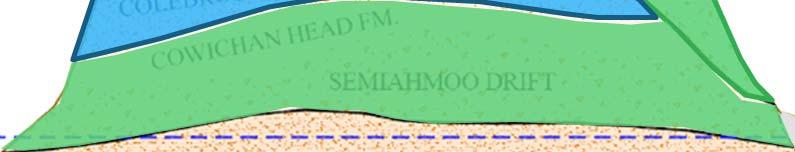
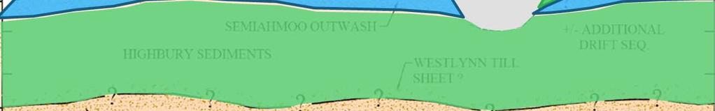
16 Lower Mainland Surficial Geology Pre Vashon Deposits Glacial, non glacial and glaciomarine sediments: Quadra glaciofluvial and fluvial channel sand and gravel; Coquitlam till, glaciomarine and glaciolacustrine deposits; Cowichan Head fluvial, organic colluvial and swamp sediments; Pre Vashon Deposits Semiahmoo till, glaciofluvial, glaciomarine and glaciolacustrine deposits; Highbury fluvial and swamp deposits; Westlyn glaciofluvial sandy gravel. Lithostratigraphic Units (Armstrong, 1984)


17 Lower Mainland Surficial Geology North Richmond Burnaby Delta Coquitlam Surrey Pitt Meadows Mission Chilliwack Mount Seymour, BC Langley Abbotsford Bedrock Sandstone, siltstone and shale at low elevations (near sea level); granites and other volcanic rocks form the uplands and the North Shore Mountains.

18 Why Is It Important? Planning for field investigation CSR Protocol 21 Drinking Water Applicability In the field Report writing Other considerations
19 Know What to Expect Before You Go Check surficial geology maps AND cross sections. You will encounter units that are not at the surface. What is the elevation? Lowland or Upland? What is the target depth? Fluvial or glacial deposits? How close is the Fraser River? Till or outwash deposits? Is bedrock expected?


20 Lowlands or Uplands? North Burnaby Coquitlam Pitt Meadows Richmond Surrey Mission Chilliwack Delta Langley Abbotsford Distribution of the three majors landscapes in the Lower Mainland
21 Know What to Expect Before You Go Check surficial geology maps AND cross sections. You will encounter units that are not at the surface. What is the elevation? Lowland or Upland? What is the target depth? Fluvial or glacial deposits? How close is the Fraser River? Till or outwash deposits? Is bedrock expected?
 Mitchell")
22 Lowlands Stratigraphy Upland Lowland Richmond SEA LEVEL Bedrock Pre Vashon Sediments Vashon Drift Capilano Sediments Fraser River Sediments Salish Sediments Diagrammatic North South Cross Section of the Fraser River Delta at (GSC Map 1486A, Surficial Geology, 1980) Mitchell Island


23 Uplands Stratigraphy Quadra Sands Outcrop UBC Schematic East West Stratigraphic Cross Section through Surrey (Gartner Lee Limited, 2004)


24 Know What to Expect Before You Go Check surficial geology maps AND cross sections. You will encounter units that are not at the surface. What is the elevation? Lowland or Upland? What is the target depth? Fluvial or glacial deposits? How close is the Fraser River? Till or outwash deposits? Is bedrock expected?
25 CSR Protocol 21 Drinking Water Applicability Is there an aquifer present? Drinking Water Aquifer: Saturated unconsolidated geological units with yields greater or equal to 1.3L/min or hydraulic conductivity greater or equal to 1 x 10 6 m/s. Is the aquifer protected? Natural confining barrier: Type A: Geological unit with hydraulic conductivity less than 1 x 10 7 m/s and minimum thickness of 5 m. Type B: Geological unit with hydraulic conductivity between 1 x 10 7 m/s and 1 x 10 6 m/s and ratio thickness/hydraulic conductivity greater than 5 x 10 7 s.


26 Lowlands Aquifers and Aquitards Upland Aquifer Aquitard Lowland Richmond SEA LEVEL Bedrock Pre Vashon Sediments Vashon Drift Capilano Sediments Fraser River Sediments Salish Sediments Diagrammatic Cross Section of the Fraser River Delta at Mitchell Island (GSC Map 1486A, Surficial Geology, 1980)


27 Uplands Aquifers and Aquitards Aquifer Aquitard Water Table Schematic east west stratigraphic cross section through Surrey (Gartner Lee Limited, 2004)

28 In the Field Is what you see what you expected? Is it consistent with regional surficial geology? Does what you see make sense? There is very little clay in till; if you think it s clay, it s probably silt! Capilano Sediments or Vashon Drift? Capilano Sediments and Fort Langley Formation were former marine deposits; look for gypsum and shells!
29 Report Writing Link field observation with regionally mapped stratigraphic units. Is site geology consistent with regionally mapped aquifers? Check on imap BC or Water Resources Atlas. Unit Core Sample Field Description Logged Geologic Unit 1 Dark grey silt, minor sand and gravel, trace roots Regional Geological Interpretation Hydrostratigraphic Unit FILL Fill Fill Aquitard 2 Organic peat, reddish brown, fibrous, stiff, wet PEAT Salish bog sediments Peat Aquitard 3 Organic silt, dark brown, trace wood debris, stiff, wet SILT Fraser River overbank sediments Silt Aquitard 4 Fine to medium grained sand grey, well sorted, loose, wet SAND Fraser River channel sediments Sand Aquifer 5 Grey fine sand, some silt, minor gravel, very dense, wet TILL Vashon Drift Till Aquitard


30 Other Considerations Natural background concentrations: Geological units can provide some information on groundwater geochemistry. Groundwater flow and contaminant Fraser River migration. Salish Sediments Sediments Drilling methods can vary depending on geological units. Clay Peat Sand & Fill Remediation remediation techniques. Silt Dissolved Arsenic Concentrations (µg/l) in Groundwater by Screened Soil Type (Goddard, 2017)

31 Key Conclusions Complex depositional processes. Lower Mainland surficial geology comprised of glacial, fluvial and marine deposits. Check surficial geology maps AND cross sections. You will encounter units that are not at the surface. Saturated outwash deposits represent good aquifers. Link field observations with regional geology. Fraser River Delta
32 References Armstrong, J.E, Environmental and Engineering Applications of the Surficial Geology of the Fraser Lowland, British Columbia. Geological Survey of Canada, Paper Clague, J. and Turner, B., 2003., city on the edge: living with a dynamic geological landscape. Gartner Lee Limited, Surrey Groundwater Strategy Phase II Part 1 Groundwater Exploration Plan. GLL Prepared for City of Surrey. Geological Survey of Canada Surficial Geology. MAP 1484A, 1485A, 1486A and 1487A. Compiled by Armstrong J.E. & Hicock S.R. Department of Energy, Mines, and Resources. Girard, F., Ghienne, J. F., and Rubino, J. L., Channelized sandstone bodies ( cordons ) in the Tassili N Ajjer (Algeria & Libya): snapshot of a Late Ordovician proglacial outwash plain. Geological Society, London, Special Publication, 368, Goddard, M.L., The baseline arsenic concentration in the groundwater of the Fraser River Delta, British Columbia, Canada. Master thesis.
33 Thank You! Questions? Presenters Contact Information: Kalina Malowany, MSc/GIT Hydrogeologist Core6 Environmental Ltd., Virginie Brunetaud, MSc/AAg Hydrogeologist Core6 Environmental Ltd.,
Geology and New England Landscapes
 Geology and New England Landscapes Jim Turenne, CPSS USDA-NRCS Warwick, RI. http://nesoil.com Why Geology? Provides the big picture of site conditions. Major part of soil formation (parent material and
The Geology of Sebago Lake State Park
 Maine Geologic Facts and Localities September, 2002 43 55 17.46 N, 70 34 13.07 W Text by Robert Johnston, Department of Agriculture, Conservation & Forestry 1 Map by Robert Johnston Introduction Sebago
Lab 7: Sedimentary Structures
 Name: Lab 7: Sedimentary Structures Sedimentary rocks account for a negligibly small fraction of Earth s mass, yet they are commonly encountered because the processes that form them are ubiquitous in the
Name: Which rock layers appear to be most resistant to weathering? A) A, C, and E B) B and D
 A, C, and E B) B and D") Name: 1) The formation of soil is primarily the result of A) stream deposition and runoff B) precipitation and wind erosion C) stream erosion and mass movement D) weathering and biological activity 2)
Name: 1) The formation of soil is primarily the result of A) stream deposition and runoff B) precipitation and wind erosion C) stream erosion and mass movement D) weathering and biological activity 2)
Lowland Glaciation North Wales
 Lowland Glaciation North Wales Background Although there have been many glaciations and advances in ice, the most significant for this are was the Dimlington Stadial which was a period of glacial advance
Subsurface Geology of the Kennebec River
 Maine Geologic Facts and Localities July, 1998 Subsurface Geology of the Kennebec River 43 54 40.75 N, 69 48 29.01 W Text by Daniel B. Locke, Department of Agriculture, Conservation & Forestry 1 Map by
Name. 4. The diagram below shows a soil profile formed in an area of granite bedrock. Four different soil horizons, A, B, C, and D, are shown.
 Name 1. In the cross section of the hill shown below, which rock units are probably most resistant to weathering? 4. The diagram below shows a soil profile formed in an area of granite bedrock. Four different
,Baynes Lake. TO...?&.?...A 2...KO.?'!!&... Sr. *logical Engineer
 > i evernment OF BRITISH COLUMBIA a TO...?&.?...A 2....KO.?'!!&... Sr. *logical Engineer... Grou,,water. Section Hydrology Division Wat.er... In~.~s.tiga.ti.On.s..Branck.... 5 u BJECT...C;.roun.dw.ater...Snve
4. The map below shows a meandering stream. Points A, B, C, and D represent locations along the stream bottom.
 1. Sediment is deposited as a river enters a lake because the A) velocity of the river decreases B) force of gravity decreases C) volume of water increases D) slope of the river increases 2. Which diagram
Our File: 92 F/1, 92 F/8. Numerous licenced springs occur north of the B.C. Hydro right-of-way on. Water Management Branch
 J.C. Foweraker, Head Groundwater Section Water Management Branch Date: May 23, 1986 Our File: 92 F/1, 92 F/8 Re: Groundwater - D.L. 117. Nanoose District As requested by Mr. B. Hollingshead, Regional Water
to represent sediments deposited through a series of marine transgressive
 i Hydrogeol ogy of Sal tsprinq s1 and Two main assemblages of rocks directly underly Saltspring sland. The Napajmo Group of Upper Cretaceous aqe comprising sedimentary rocks lies in th, brthern half and
Figure 1 The map shows the top view of a meandering stream as it enters a lake. At which points along the stream are erosion and deposition dominant?
 1. In which type of climate does chemical weathering usually occur most rapidly? 1. hot and dry 3. cold and dry 2. hot and wet 4. cold and wet 2. Figure 1 The map shows the top view of a meandering stream
Appendix F4.11 Geologic Unit Summaries, Hazard Areas, and Boring Locations
 Appendix F4.11 Geologic Unit Summaries, Hazard Areas, and Boring Locations Appendix F4.11 Geologic Unit Summaries and Hazard Areas TABLE F4.11-1 Summary of Geologic Units and their Engineering Properties
1. The map below shows a meandering river. A A' is the location of a cross section. The arrows show the direction of the river flow.
 1. The map below shows a meandering river. A A' is the location of a cross section. The arrows show the direction of the river flow. Which cross section best represents the shape of the river bottom at
Your web browser (Safari 7) is out of date. For more security, comfort and the best experience on this site: Update your browser Ignore
 is out of date. For more security, comfort and the best experience on this site: Update your browser Ignore") Your web browser (Safari 7) is out of date. For more security, comfort and the best experience on this site: Update your browser Ignore BEDRO CK For the complete encyclopedic entry with media resources,
Your web browser (Safari 7) is out of date. For more security, comfort and the best experience on this site: Update your browser Ignore BEDRO CK For the complete encyclopedic entry with media resources,
 Page 1 of 9 Name: Base your answer to the question on the diagram below. The arrows show the direction in which sediment is being transported along the shoreline. A barrier beach has formed, creating a
Geology of Havering-atte-Bower
 Geology of Havering-atte-Bower The geology of Havering village consists of deposits of clays, gravels and sands variously classed as bedrock and superficial deposits. Clays and sands seem rather dull but
11/22/2010. Groundwater in Unconsolidated Deposits. Alluvial (fluvial) deposits. - consist of gravel, sand, silt and clay
 deposits. - consist of gravel, sand, silt and clay") Groundwater in Unconsolidated Deposits Alluvial (fluvial) deposits - consist of gravel, sand, silt and clay - laid down by physical processes in rivers and flood plains - major sources for water supplies
Groundwater in Unconsolidated Deposits Alluvial (fluvial) deposits - consist of gravel, sand, silt and clay - laid down by physical processes in rivers and flood plains - major sources for water supplies
What are the different ways rocks can be weathered?
 Romano - 223 What are the different ways rocks can be weathered? Weathering - the breakdown of rocks and minerals at the Earth s surface 1. 2. PHYSICAL WEATHERING Rock is broken into smaller pieces with
Integrating 3-D Facies Analysis of Glacial Aquifer Systems with Groundwater Flow Models: Examples from New England and the Great Lakes Region, USA
 Integrating 3-D Facies Analysis of Glacial Aquifer Systems with Groundwater Flow Models: Examples from New England and the Great Lakes Region, USA Stone, B.D., J.R. Stone, J.P. Masterson, and D.W. O'Leary
Page 1. Name:
 Name: 1) Which property would best distinguish sediment deposited by a river from sediment deposited by a glacier? thickness of sediment layers age of fossils found in the sediment mineral composition
Geology of the Black River and Paw Paw River Watersheds. Dr. Tara Kneeshaw Grand Valley State University Department of Geology
 Geology of the Black River and Paw Paw River Watersheds Dr. Tara Kneeshaw Grand Valley State University Department of Geology Two Rivers Coalition September 11, 2013 There s nothing boring about Michigan
Glacial Geology of Moose Point State Park, ME
 Geologic Site of the Month May, 2013 Glacial Geology of Moose Point State Park, Maine 44 o 25 59.18"N, 68 o 56 37.11"W Text and photos by Woodrow B. Thompson, Department of Agriculture, Conservation &
2 Geology of groundwater
 2 Geology of groundwater As we ve already discussed, aquifers can be divided into two main types depending on their host materials. Unconsolidated sediments overly bedrock in many areas, and can be very
Investigating Background Groundwater Quality at Contaminated Sites A Hydrogeochemical Approach
 Investigating Background Groundwater Quality at Contaminated Sites A Hydrogeochemical Approach Remediation Technologies Symposium 2011, Banff, Alberta (October 2011) Presented by: Stephen Munzar 1 Presentation
THE LATE QUATERNARY SURFICIAL GEOLOGY AND GEOMORPHOLOGY OF THE LOWER SEYMOUR VALLEY, NORTH VANCOUVER, BRITISH COLUMBIA
 THE LATE QUATERNARY SURFICIAL GEOLOGY AND GEOMORPHOLOGY OF THE LOWER SEYMOUR VALLEY, NORTH VANCOUVER, BRITISH COLUMBIA Olav Benneth Lian B.Sc. (physics), Simon Fraser University, 1988 THESIS SUBMITTED
Jim Turenne. Soils on Social Media
 Jim Turenne USDA-NRCS 60 Quaker Lane, Suite 46 Warwick, RI. 02886 401-822-8832 Jim.turenne@ri.usda.gov Soils on Social Media www.twitter.com/soilsne www.fb.com/soilsne www.nesoil.com U.S. Department of
Sediment and sedimentary rocks Sediment
 Sediment and sedimentary rocks Sediment From sediments to sedimentary rocks (transportation, deposition, preservation and lithification) Types of sedimentary rocks (clastic, chemical and organic) Sedimentary
The boulder was most likely moved to this location by A) glacial ice B) prevailing wind C) streamfiow D) volcanic action
 glacial ice B) prevailing wind C) streamfiow D) volcanic action") 1. Which rock material was most likely transported to its present location by a glacier? A) rounded sand grains found in a river delta B) rounded grains found in a sand dune C) residual soil found on a
1. Which rock material was most likely transported to its present location by a glacier? A) rounded sand grains found in a river delta B) rounded grains found in a sand dune C) residual soil found on a
Fraser Valley Geotour:
 : Bedrock, Glacial Deposits, Recent Sediments, Geological Hazards and Applied Geology: Sumas Mountain and Abbotsford Area A collaboration in support of teachers in and around Abbotsford, B.C. in celebration
RIVERS, GROUNDWATER, AND GLACIERS
 RIVERS, GROUNDWATER, AND GLACIERS Delta A fan-shaped deposit that forms when a river flows into a quiet or large body of water, such as a lake, an ocean, or an inland sea. Alluvial Fan A sloping triangle
Mass Movements, Wind, and Glaciers
 Mass Movements,, and Glaciers SECTION 8.1 Mass Movement at Earth s Surface In your textbook, read about mass movement. Use each of the terms below just once to complete the passage. avalanche creep landslide
Guided Notes Surface Processes. Erosion & Deposition By: Glaciers
 Guided Notes Surface Processes Erosion & Deposition By: Glaciers K. Coder 2015 26) How does moving ice erode and deposit sediments? Glaciers (Movement of Ice): a naturally formed mass of ice and snow that
Topic 6: Weathering, Erosion and Erosional-Deposition Systems (workbook p ) Workbook Chapter 4, 5 WEATHERING
 Workbook Chapter 4, 5 WEATHERING") Topic 6: Weathering, Erosion and Erosional-Deposition Systems (workbook p. 95-125) Workbook Chapter 4, 5 THE BIG PICTURE: Weathering, erosion and deposition are processes that cause changes to rock material
Topic 6: Weathering, Erosion and Erosional-Deposition Systems (workbook p. 95-125) Workbook Chapter 4, 5 THE BIG PICTURE: Weathering, erosion and deposition are processes that cause changes to rock material
Depositional Environment
 Depositional Environment Sedimentary depositional environment describes the combination of physical, chemical and biological processes associated with the deposition of a particular type of sediment. Types
Essential Questions. What is erosion? What is mass wasting?
 Erosion Essential Questions What is erosion? What is mass wasting? What is Erosion? Erosion The transportation of sediment from one area to another Caused mainly by running water but also caused by glaciers,
SD-100 SD-200 SITE AND EXPLORATION PLAN SODO SEGMENT. FIG. 3 Sheet 4 of 9. Seattle Monorail Project Seattle, Washington Scale in Feet
 Central Parking Lot potential downhole arrary location (site visit //) PREFERRED New Parking Area File: I: \Drafting \\- \plans \-- Plans.dwg Date: -- Author: LR Current downhole array location LEGEND
1. The diagram below shows the stump of a tree whose root grew into a small crack in bedrock and split the rock apart.
 1. The diagram below shows the stump of a tree whose root grew into a small crack in bedrock and split the rock apart. 4. Which process involves either a physical or chemical breakdown of earth materials?
1. Any process that causes rock to crack or break into pieces is called physical weathering. Initial product = final product
 Weathering 1. Any process that causes rock to crack or break into pieces is called physical weathering. Initial product = final product End Result of physical weathering is increased surface area. 2. Physical
Which landscape best represents the shape of the valleys occupied by glaciers? A) B) C) D)
 B) C) D)") 1. Glaciers often form parallel scratches and grooves in bedrock because glaciers A) deposit sediment in unsorted piles B) deposit rounded sand in V-shaped valleys C) continually melt and refreeze D) drag
1. Glaciers often form parallel scratches and grooves in bedrock because glaciers A) deposit sediment in unsorted piles B) deposit rounded sand in V-shaped valleys C) continually melt and refreeze D) drag
How & Where does infiltration work? Summary of Geologic History Constraints/benefits for different geologic units
 June 26, 2007: Low Impact Development 1 Associated Earth Sciences, Inc. Associated Earth Sciences, Inc. Presented by: Matthew A. Miller, PE April 24, 2012 How & Where does infiltration work? Summary of
Moosehead Lake and the Tale of Two Rivers
 Maine Geologic Facts and Localities June, 2005 45 o 53 5.09 N, 69 o 42 14.54 W Text by Kelley, A.R.; Kelley, J.T.; Belknap, D.F.; and Gontz, A.M. Department of Earth Sciences, University of Maine, Orono,
Characterisation of Quaternary deposits in West Cumbria using the concept of domains: A case study
 Characterisation of Quaternary deposits in West using the concept of domains: a case study Characterisation of Quaternary deposits in West using the concept of domains: A case study Jon Merritt Quaternary
The Palmer Hill Glacial-Marine Delta, Whitefield, Maine
 Maine Geologic Facts and Localities December, 2010, Maine 44 o 10 12.16 N, 69 o 37 18.93 W Text by Woodrow Thompson, Department of Agriculture, Conservation & Forestry 1 Introduction The most recent continental
Pratice Surface Processes Test
 1. The cross section below shows the movement of wind-driven sand particles that strike a partly exposed basalt cobble located at the surface of a windy desert. Which cross section best represents the
Lecture Outline Lecture Outline Monday April 9-16, 2018 Questions? Announcements:
 Lecture Outline Lecture Outline Monday April 9-16, 2018 Questions? Announcements: Geology 101 Night Video: The Day After Tomorrow Hollywood disaster movie about the onset of a glacial period When: Monday
Michigan s Geology and Groundwater
 Michigan s Geology and Groundwater Ralph J. Haefner Deputy Director U.S. Geological Survey Michigan-Ohio Water Science Center Lansing, Michigan Outline About the USGS Geology 101 Michigan s geology Bedrock
Unit 3 Review - Surface Processes
 Unit 3 Review - Surface Processes 1. Why is the surface of Mercury covered with meteor impact craters, while Earth s surface has relatively few craters? A) Mercury is larger than Earth, so it gets hit
Page 1. Name:
 Name: 1) Which event is the best example of erosion? dissolving of rock particles on a limestone gravestone by acid rain breaking apart of shale as a result of water freezing in a crack rolling of a pebble
Name: Mid-Year Review #2 SAR
 Name: Mid-Year Review #2 SAR Base your answers to questions 1 through 3 on on the diagram below, which shows laboratory materials used for an investigation of the effects of sediment size on permeability,
Betsy Stevenson and Allison Mohrs (Skagit County Planning and Development Services) Jenny Baker, The Nature Conservancy
 Jenny Baker, The Nature Conservancy") TC Fisher Slough Final Design and Permitting Subject: Well Review Memorandum To: From: Betsy Stevenson and Allison Mohrs (Skagit County Planning and Development Services) Jenny Baker, The ature Conservancy
TC Fisher Slough Final Design and Permitting Subject: Well Review Memorandum To: From: Betsy Stevenson and Allison Mohrs (Skagit County Planning and Development Services) Jenny Baker, The ature Conservancy
EXTERNAL LAND FORMING PROCESSES
 NAME SCHOOL INDEX NUMBER DATE EXTERNAL LAND FORMING PROCESSES WEATHERING 1 1998 Q 7 (a) (i) What is the difference between weathering and mass wasting (ii) List five processes involved in chemical weathering
How to Identify and Properly Classify Drill Cuttings
 How to Identify and Properly Classify Drill Cuttings (Creating Useful Borehole Logs) Dave Larson Hydrogeology and Geophysics Section Accurate information about the borehole location and a careful description
Module 10: Resources and Virginia Geology Topic 4 Content: Virginia Geology Notes
 Virginia is composed of a very diverse landscape that extends from the beaches and barrier islands all of the way to the highly elevated Appalachian Plateau. Geologists have discovered ancient shallow
GEOL.3250 Geology for Engineers Glacial Geology
 GEOL.3250 Geology for Engineers Glacial Geology NAME Part I: Continental Glaciation Continental glaciers are large ice sheets that cover substantial portions of the land area. In the region of accumulation
Northwest Geological Society Society Field Trips in Pacific Northwest Geology
 Northwest Geological Society Society Field Trips in Pacific Northwest Geology Field Trip Guidebook # 10 Quaternary Geology of the Tacoma Area June 26-27 1999 Kathy G. Troost Derek B. Booth Patrick Pringle
Chapter 6 Sedimentary and Metamorphic Rock
 Chapter 6 Sedimentary and Metamorphic Rock Weathering and Erosion Wherever rock is exposed at Earth s surface, it is continuously being broken down by weathering a set of physical and chemical processes
SASKATCHEWAN STRATIGRAPHY GLACIAL EXAMPLE BOULDERS IN GLACIAL DEPOSITS
 SASKATCHEWAN STRATIGRAPHY GLACIAL EXAMPLE BOULDERS IN GLACIAL DEPOSITS 51 SASKATCHEWAN STRATIGRAPHY GLACIAL SURFICIAL STRATIFIED DEPOSITS 52 SASKATCHEWAN STRATIGRAPHY GLACIAL EXAMPLE OF SEDIMENT DEPOSITION
Sunshine Coast Aggregate Potential Mapping Project
 Sunshine Coast Aggregate Potential Mapping Project By Ahren J. Bichler, Elizabeth D. Brooks and Peter T. Bobrowsky KEYWORDS: Aggregate, aggregate potential mapping, sand and gravel, Sechelt, Powell River,
THE ACTION OF GLACIERS
 Surface processes THE ACTION OF GLACIERS Glaciers are enormous masses of ice which are formed due to accumulation, compaction and re-crystallisation of the snow deposited in very cold regions (the majority
Maggie Payne Jim Turenne
 Maggie Payne Jim Turenne USDA-NRCS 60 Quaker Lane, Suite 46 Warwick, RI. 02886 401-822-8832 maggie.payne@ri.usda.gov U.S. Department of Agriculture 1935: Soil Conservation Service (SCS) Natural Resources
Mammoth Cave National Park, Kentucky
 Mammoth Cave National Park, Kentucky Objectives of Today s Lecture Refresher on Sedimentary Depositional Systems and Rock Classifications Transgressive and Regressive Marine Environments Carbonate Depositional
Landscape. Review Note Cards
 Landscape Review Note Cards Last Ice Age Pleistocene Epoch that occurred about 22,000 Years ago Glacier A large, long lasting mass of ice which forms on land and moves downhill because of gravity. Continental
MASS MOVEMENTS, WIND, AND GLACIERS
 Date Period Name MASS MOVEMENTS, WIND, AND GLACIERS SECTION.1 Mass Movements In your textbook, read about mass movements. Use each of the terms below just once to complete the passage. avalanche creep
Unit 4: Landscapes Practice Problems
 Name: Date: 1. Soil with the greatest porosity has particles that are A. poorly sorted and densely packed B. poorly sorted and loosely packed C. well sorted and densely packed D. well sorted and loosely
Glacial Modification of Terrain
 Glacial Modification Part I Stupendous glaciers and crystal snowflakes -- every form of animate or inanimate existence leaves its impress upon the soul of man. 1 -Orison Swett Marden Glacial Modification
- Cased-hole geophysical well logs - Airborne geophysics - Seismic data - LiDAR. GeoConvention 2015: New Horizons 1
 Thermal Effects and Quaternary Hydrogeology: Making Good Decisions in a Complex Geologic Setting Timothy Johnsen, Phd, Quaternary Specialist (tjohnsen@matrix-solutions.com) Alex Haluszka, MSc, P.Geol.,
Connecticut's Aquifers
 Page 1 of 5 DEP Search: Connecticut's Aquifers The technical definition of the word "aquifer" is: any geologic formation capable of yielding significant quantities of water to wells. By that definition,
MEMORANDUM. wa.tsr..-z.n~.e.s-t.i~at.i.o.ns... Branch... Mr. Webster contends that prior to excavation of the gravel
 TO... J. C. Foweraker 2... Head Gr o w a t er S e c t i on... Hyar....og~~~.~.~vis.ion... wa.tsr..-z.n~.e.s-t.i~at.i.o.ns... Branch... eernment OF BRITISH COLUMBIA MEMORANDUM II 0 PROM A. P. Kohut, Geological
Name Roy G Biv Page 1
 Name Roy G Biv Base your answers to questions 1 through 3 on the diagram below. The arrows show the direction in which sediment is being transported along the shoreline. A barrier beach has formed, creating
April
 April 2016 5 993-1410-007.006 2.0 PHYSICAL SETTING AND HYDROGEOLOGY This section provides background information on the physical setting and hydrogeology of the Tumwater area based on previous investigations
Section 11.1 pp Where Mountains Form
 Section 11.1 pp. 236 237 Where Mountains Form Chapter 11 Set a Purpose: TE, p. 236 Reading Study Guide, p. 36 Discussion: TE, p. 236 Differentiating ion Reading Support: TE, p. 236 Visual Teaching Interpret
1. Which type of climate has the greatest amount of rock weathering caused by frost action? A) a wet climate in which temperatures remain below
 a wet climate in which temperatures remain below") 1. Which type of climate has the greatest amount of rock weathering caused by frost action? A) a wet climate in which temperatures remain below freezing B) a wet climate in which temperatures alternate
1. Which type of climate has the greatest amount of rock weathering caused by frost action? A) a wet climate in which temperatures remain below freezing B) a wet climate in which temperatures alternate
Weathering of Rocks. Weathering - Breakdown of rocks into pieces (sediment) 2 main types of weathering to rocks
 2 main types of weathering to rocks") Weathering of Rocks Weathering - Breakdown of rocks into pieces (sediment) 2 main types of weathering to rocks Mechanical weathering requires physical forces to break rocks into smaller pieces. Chemical
Weathering of Rocks Weathering - Breakdown of rocks into pieces (sediment) 2 main types of weathering to rocks Mechanical weathering requires physical forces to break rocks into smaller pieces. Chemical
Soils, Hydrogeology, and Aquifer Properties. Philip B. Bedient 2006 Rice University
 Soils, Hydrogeology, and Aquifer Properties Philip B. Bedient 2006 Rice University Charbeneau, 2000. Basin Hydrologic Cycle Global Water Supply Distribution 3% of earth s water is fresh - 97% oceans 1%
THE OHIO JOURNAL OF SCIENCE
 THE OHIO JOURNAL OF SCIENCE VOL. LIII MARCH, 1953 No. 2 SUBSURFACE STUDY OF GLACIAL DEPOSITS AT CLEVELAND, OHIO C. T. BAGLEY Sverdrup & Parcel, Inc., Consulting Engineers, St. Lotus, Mo. The soil 1 strata
PROMISED LAND STATE PARK PIKE COUNTY ANCIENT RIVERS AND AGES OF ICE
 PENNSYLVANIA TRAIL OF GEOLOGY PARK GUIDE 18 PROMISED LAND STATE PARK PIKE COUNTY ANCIENT RIVERS AND AGES OF ICE Promised Land State Park is located on a broad upland surface known as the Pocono Plateau.
10/27/2014. Surface Processes. Surface Processes. Surface Processes. Surface Processes. Surface Processes
 Hewitt/Lyons/Suchocki/Yeh Conceptual Integrated Science Chapter 25 Surface or surficial processes originate at Earth's surface and reshape its contours. Surface processes include: Weathering Erosion Deposition
The Lee River Landslide
 The Lee River Landslide Meghan O'Donnell Jon Bevan Geomorphology December 5, 2003 Abstract: Steep hillslopes that lie adjacent to active stream channels are prone to landsliding. Glaciolacustrine material
Groundwater Investigation SOUTHGATE GRAVEL PIT Part of Lot 15, Concession 15 (formerly Township of Proton), Township of Southgate.
, Township of Southgate.") Groundwater Investigation SOUTHGATE GRAVEL PIT Part of Lot 15, Concession 15 (formerly Township of Proton), Township of Southgate County of Grey October, 2014 Prepared for: Drysdale Aggregate Consulting
Groundwater Investigation SOUTHGATE GRAVEL PIT Part of Lot 15, Concession 15 (formerly Township of Proton), Township of Southgate County of Grey October, 2014 Prepared for: Drysdale Aggregate Consulting
Paleo Lab #4 - Sedimentary Environments
 Paleo Lab #4 - Sedimentary Environments page - 1. CHARACTERISTICS OF SEDIMENT Grain size and grain shape: The sizes and shapes of sedimentary particles (grains) are modified considerably during their transportation
Weathering, Erosion and Deposition
 Weathering, Erosion and Deposition Shaping the Earth s Surface Weathering the process of breaking down rocks into smaller fragments Erosion the transport of rock fragments from one location to another
Sedimentary Rocks, our most Valuable Rocks. Or, what you will probably find when you are outdoors exploring.
 Sedimentary Rocks, our most Valuable Rocks Or, what you will probably find when you are outdoors exploring. Sedimentary rocks give us evidence to earth s earlier history. We look at processes happening
Pre-Lab Reading Questions ES202
 ES202 The are designed to encourage students to read lab material prior to attending class during any given week. Reading the weekly lab prior to attending class will result in better grade performance
Objectives. Introduction to Soils. Terms to know: What is soil? Study of Soils. The Soil Body 11/9/2012
 Objectives Explain what soil is and where it comes from Define a soil body List examples of the five soil-forming factors Explain how soils develop Introduction to Soils Terms to know: What is soil? Alluvial
How do glaciers form?
 Glaciers What is a Glacier? A large mass of moving ice that exists year round is called a glacier. Glaciers are formed when snowfall exceeds snow melt year after year Snow and ice remain on the ground
Resume components. Assignments due Monday. Shape of Puget Sound. Formation and bathymetry
 Assignments due Monday Resume Top four choices of projects, in order of preference One paragraph proposal about topic of choice Weekly schedule Topics you d like to cover in class Math: Complete the calculus
UNIT 4: Earth Science Chapter 21: Earth s Changing Surface (pages )
") CORNELL NOTES Directions: You must create a minimum of 5 questions in this column per page (average). Use these to study your notes and prepare for tests and quizzes. Notes will be turned in to your teacher
CORNELL NOTES Directions: You must create a minimum of 5 questions in this column per page (average). Use these to study your notes and prepare for tests and quizzes. Notes will be turned in to your teacher
SEISMIC VELOCITIES OF UNCONSOLIDATED SEDIMENTS IN THE VANCOUVER AREA OF BRITISH COLUMBIA
 GEOGRAPHICA 41 1 REFERE.NCES ABOAV. D.A. (1970). The arrangement of grains in a polycrystal, Metallography, 3: 383-90. BOOTS, B.M. (1975). Some observations on the structure of socioeconomic cellular networks,
Geology 12 FINAL EXAM PREP. Possible Written Response Exam Questions
 Geology 12 FINAL EXAM PREP Possible Written Response Exam Questions Use this study guide to prepare for the written response portion of the final exam. Name FINAL EXAM - POSSIBLE WRITTEN RESPONSE QUESTIONS
unit 6 Review sheet 4. The photograph below shows a sandstone butte in an arid region. A. U-shaped valley B. V-shaped valley C. cliff D.
 Name: ate: 1. The large waterfall at Niagara Falls, New York, was originally located at the Niagara Escarpment. Which term best describes an escarpment? 4. The photograph below shows a sandstone butte
.+. Mapping the shallowest surface of more compact sediments predating Fraser River deltaic deposits GEOLOGICAL SURVEY OF CANADA OPEN FILE 3563
 GEOLOGICAL SURVEY OF CANADA OPEN FILE 3563 Mapping the shallowest surface of more compact sediments predating Fraser River deltaic deposits T.M. McGee, J.A. Hunter, R.A. Spence and J.L. Luternauer 1998.+.
The Building of the NYC Region
 The Building of the NYC Region Definitions Fall Line marks the area where an upland region (continental bedrock) and a coastal plain meet Piedmont the plateau region of the eastern United States which
The Agents of Erosion
 The Agents of Erosion 1. Erosion & Deposition 2. Water 3. Wind 4. Ice California Science Project 1 1. Erosion and Deposition Erosion is the physical removal and transport of material by mobile agents such
Surficial Geology of Antioch Quadrangle
 Illinois Preliminary Geologic Map IPGM Antioch-SG Surficial Geology of Antioch Quadrangle Lake County, Illinois and Kenosha County, Wisconsin Andrew J. Stumpf and Michael L. Barnhardt 2005 Department of
Chapter 2. Denudation: Rivers and Ice
 Chapter 2. Denudation: Rivers and Ice DENUDATION: process that lowers level of land - caused by rivers, glaciers, waves & wind - involves processes of WEATHERING & EROSION Weathering Def: breakdown of
Chapter 5. The Sedimentary Archives
 Chapter 5 The Sedimentary Archives Factors affecting Sedimentary Characteristics 1. Tectonic setting 2. Physical, chemical, and biological processes in the depositional environment 3. Method of sediment
HW #2 Landscape Travel from A to B 12,
 HW #2 Landscape 2016 Section: Name: ate: 1. ase your answer(s) to the following question(s) on the map below, which represents two bridges that cross the Green River. Letters,, and represent locations
THE JUAN DE FUCA LOBE OF THE CORDILLERAN ICE SHEET
 THE JUAN DE FUCA LOBE OF THE CORDILLERAN ICE SHEET There were two large glaciers in western Washington during the latest, or Vashon, glaciation of that region. Each was essentially an elongated lobe of
What is a Glacier? Types of Glaciers
 Alpine & Continental Glaciers Glacial Mass Balance Glacial Ice Formation Glacial Movement & Erosion Erosional and Depositional Landforms The Pleistocene Epoch Geomorphology of SW Manitoba Chapter 17 1