Boundaries and Borders
|
|
|
- Merry Holmes
- 5 years ago
- Views:
Transcription
1 Political Geography
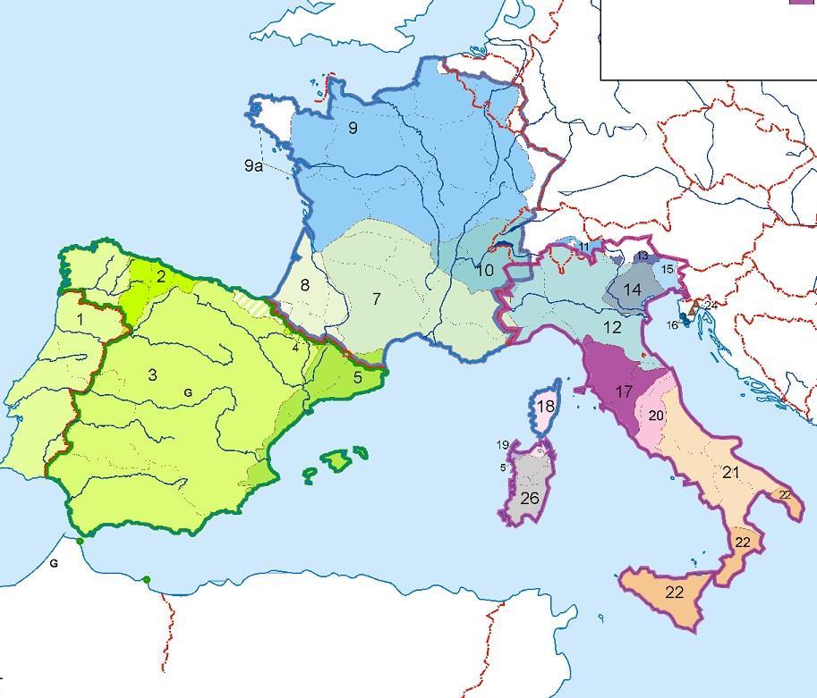
2 Origins: Antecedent Boundaries and Borders Existed in prehistoric times Usually align with physical boundaries Pyrenees between France/Spain Cultural linguistic borders between Germanic and Romance Europe along Rhine River and Alps South Asia/East Asia = Himalayas
3
4 Origins: Antecedent Boundaries and Borders Exist from prehistoric times Subsequent Resulting from changes brought on by conflict/culture Peace of Westphalia Post WWI and Post-WWII Europe


5
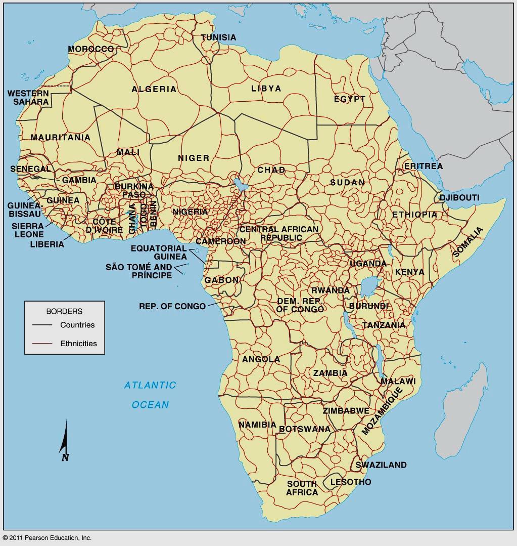
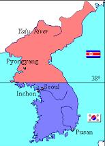
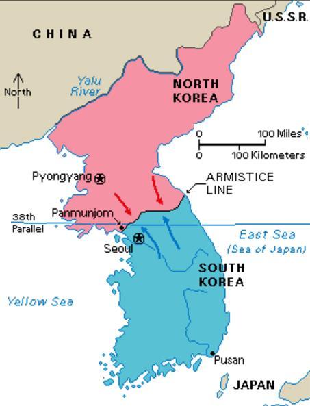
6 Origins: Antecedent Boundaries and Borders Exist from prehistoric times Subsequent Resulting from changes brought on by conflict/culture Superimposed Lines laid down for political reasons disregarding cultural boundaries the Scramble for Africa Korea
7
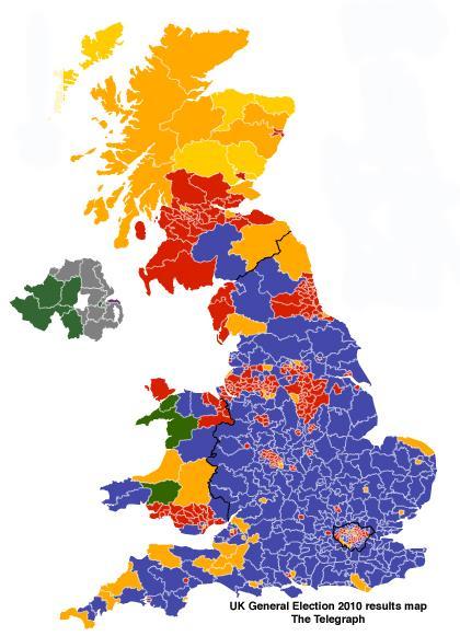
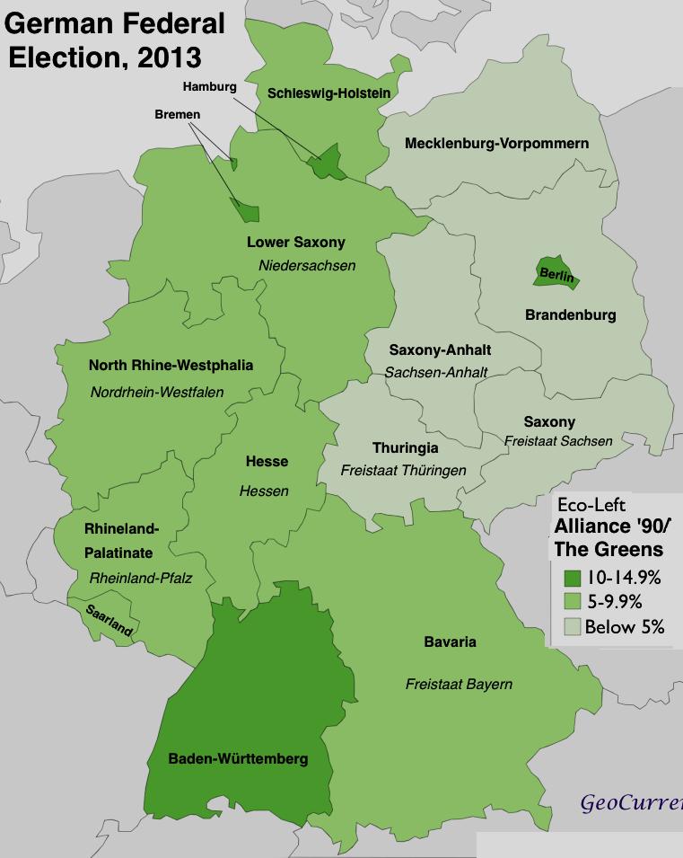
8 Origins: Antecedent Boundaries and Borders Exist from prehistoric times Subsequent Resulting from changes brought on by conflict/culture Superimposed Lines laid down for political reasons disregarding cultural boundaries Relic Former boundary that still has meaning Scotland and England after UK North and South Vietnam East and West Germany
9


10
11 Origins: Antecedent Boundaries and Borders Exist from prehistoric times Subsequent Resulting from changes brought on by conflict/culture Superimposed Lines laid down for political reasons over cultural boundaries Relic Former boundary that still has meaning Process: (not mutually exclusive) Definition Claimed, negotiated or captured Delimitation drawn on a map Demarcation Markers placed on ground to show
12 Boundaries and Borders Types: Physical Natural geography like rivers, lakes, oceans, mountains or deserts Cultural Human features (language, religions, other) isogloss Geometric Survey lines usually along lines of latitude and longitude

13 Borders extend in a plane above and below the Earth
14 Boundaries and Borders Types: Physical Natural geography like rivers, lakes, oceans, mountains or deserts Cultural Human features (language, religions, other) isogloss Geometric Survey lines usually along lines of latitude and longitude Disputes: Definitional Treaties are interpreted two different ways. Legal dispute. Locational When the border moves (ie: a river changes course) overlaps with definitional Operational Border is recognized, but passage becomes problematic Immigration/trade Allocational When a resource lies on two sides of border
15 Water Boundaries at Sea Est. by the UN Conference on the Law of the Seas (ratified 1994) Territorial Sovereignty extends 12 nautical miles from shore All national laws apply Beyond 12 mi. = high seas, admiralty law applies Exclusive Economic Zone (EEZ) Exclusive economic rights extend 200 nautical miles from shore Natural resources, fishing, etc. Usually beyond continental shelf Often overlap, generally split halfway, but many areas are under dispute

16
17 Transition Zones Until recently many boundaries were not sharp, clearly defined lines, but were zones called marchlands Frontiers - area between two states or between inhabited and uninhabited areas Now rare since most modern govts. have technology and want to exploit all territory to the fullest Buffer state independent but weak country lying between two powerful countries Mongolia lies between Russia and China Afghanistan- lied between Russian Empire and British India Satellite state -- a buffer state that falls under the domination of one of its powerful neighbors and loses much of its independence (aka: puppet state) Eastern European countries under Soviet domination during the Cold War

18
Nation: geographic area that is dominated by a large population that shares a common history and culture, ie. Kurds and Palestinians.
 Nation: geographic area that is dominated by a large population that shares a common history and culture, ie. Kurds and Palestinians. State: sovereign (implies a state's lawful control over it's territory
UNIT 4: POLITICAL ORGANIZATION OF SPACE
 UNIT 4: POLITICAL ORGANIZATION OF SPACE Advanced Placement Human Geography Session 1 ADVANCED PLACEMENT HUMAN GEOGRAPHY REVIEW SESSIONS: UNIT FOUR By Geri Flanary To accompany AP Human Geography: A Study
Name three countries in Europe.
 Name three countries in Europe. I will be able to identify the 5 themes of geography for Europe and locate the countries and capitals of Europe and the major physical features. People: Past: Through the
Geographical Characteristics of the State. The Cultural Mosaic Fellman, and Notes from D.J. Zeigler of Old Dominion
 Geographical Characteristics of the State The Cultural Mosaic Fellman, and Notes from D.J. Zeigler of Old Dominion Vocab Review State Sovereignty Nation Nation-state Binational or Multinational Stateless
Some Very Helpful Boundary and Border Definitions
 Some Very Helpful Boundary and Border Definitions Key Terms and Definitions: Boundary - something that indicates bounds or limits. Boundary Delimitation - political boundaries on Earth's surface are determined
National Council for Geographic Education Curriculum & Instruction Committee Geography Club Submitted by: Steve Pierce
 National Council for Geographic Education Curriculum & Instruction Committee Geography Club Submitted by: Steve Pierce stevepierce@charter.net Ninth Month Activities Geography for Life: National Geography
Chapter 8. Political Geography
 Chapter 8 Political Geography Nations of the World Today human geographers emphasize a thematic approach, concerned with the location of activities in the world, the reasons for particular spatial distributions,
Map Skills Test. 1. What do we call a person who makes maps? a. mapographer b. cartographer c. geologist d. archaeologist
 Map Skills Test 1. What do we call a person who makes maps? a. mapographer b. cartographer c. geologist d. archaeologist 2. What is the name of the 0 latitude line? a. Equator b. Arctic Circle c. First
Key Issue #1. Where are states located?
 Political Geography Key Issue #1 Where are states located? Current World States State and Nation Terminology A nation is a group of people with a common ancestral heritage based on belief systems, customs,
September 14, 2013 Objective: How does geography impact history? What important features exist that have shaped societies?
 Lowenhaupt 1 September 14, 2013 Objective: How does geography impact history? What important features exist that have shaped societies? Warm-Up: In your binder, answer the following question: Imagine you
Explain the impact of location, climate, natural resources, and population distribution on Europe. a. Compare how the location, climate, and natural
 SS6G10 Explain the impact of location, climate, natural resources, and population distribution on Europe. a. Compare how the location, climate, and natural resources of Germany, the United Kingdom and
The Arctic Cold War The battle to control resources while the future of the earth hangs in the balance.
 The Arctic Cold War The battle to control resources while the future of the earth hangs in the balance. 1 The Arctic Cold War The battle to control resources while the future of the earth hangs in the
Chapter 1: Europe Part 1: Teacher Notes
 Chapter 1: Europe Part 1: Teacher Notes Introduction: Over the past 5 centuries Europe has influenced and changed the world more than any other realm Helped create new societies o Through imperialism &
Sam Bateman and. State Practice Regarding Straight Baselines In East Asia Legal, Technical and Political Issues in a
 State Practice Regarding Straight Baselines In East Asia Legal, Technical and Political Issues in a Changing Environment Sam Bateman and Clive Schofield The Australian National Centre for Ocean Resources
Central Valley School District Social Studies Curriculum Map Grade 7. August - September
 August - September Geographical/Historical Skills Identify and analyze timelines. Construct and use cause and effect charts. Differentiate between fact and opinion. Use of word webs, flip charts, outlines
Blooms: Knowledge Learning Objective: Understand how states and nations are organized.
 Human Geography, 11 th edition Practice Questions Chapter 08 1. Geographers define as the study of the political organization of the world. A. the United Nations B. political science C. political economy
Chapter 1. Social Studies History and Geography
 Chapter 1 Social Studies History and Geography Unit 01 Geography Skills 1 Reading Maps Key Words border landform rely on display focus on route locater 1 There are many different kinds of maps. A political
LEARNING OUTCOMES SST (G1-G12)
") LEARNING OUTCOMES SST (G1-G12) Grade 1 Learning Outcomes Students will be expected to: - demonstrate an understanding of the importance of interactions between people - demonstrate an understanding of
LEARNING OUTCOMES SST (G1-G12) Grade 1 Learning Outcomes Students will be expected to: - demonstrate an understanding of the importance of interactions between people - demonstrate an understanding of
By Geri Flanary To accompany AP Human Geography: A Study Guide 3 rd edition By Ethel Wood
 Session 1 By Geri Flanary To accompany AP Human Geography: A Study Guide 3 rd edition By Ethel Wood WHAT IS DEMOGRAPHY? It is the scientific or statistical study of population. It comes from the Greek
About places and/or important events Landmarks Maps How the land is, hills or flat or mountain range Connected to maps World Different countries
 What do you think you know about geography? About places and/or important events Landmarks Maps How the land is, hills or flat or mountain range Connected to maps World Different countries What do you
Chapter 12: Pacific Realm and Polar Futures
 Geography: Realms, Regions and Concepts 15 th Edition By de Blij and Muller Chapter 12: Pacific Realm and Polar Futures Defining the Realm Sea Hemisphere: seas covering nearly an entire hemisphere Fragmented,
Grade 6 Social Studies
 Unit Title: Africa : Movement Location Place Human Region : Subject/Course: 6 th Grade Social Studies Essential Questions: peoples, cultures and ideas of the world? How is a location identified using map
... Asia. Based on Bloom s Taxonomy. Human & Movement. Location Place. Regions. Environment. Interactions
 ... Asia Location Place Human & Environment Interactions Movement Regions LEVEL 1 Knowledge Match Show or Label List Information Recall Details (5Ws + H) Find Information LEVEL 2 Comprehension LEVEL 3
Slide 1 Geography: Realms, Regions, and Concepts 15 th Edition. Slide 2. Slide 3 Defining the Realm. Chapter 12: Pacific Realm and Polar Futures
 Slide 1 Geography: Realms, Regions, and Concepts 15 th Edition Chapter 12: Pacific Realm and Polar Futures Slide 2 Slide 3 Defining the Realm Sea Hemisphere: seas cover nearly an entire hemisphere: Fragmented,
Iceland and the Arctic: The Politics of Territoriality. Valur Ingimundaron Professor of Contemporary History, University of Iceland
 Iceland and the Arctic: The Politics of Territoriality Valur Ingimundaron Professor of Contemporary History, University of Iceland Drivers of Icelandic Arctic Policies Geostrategic Position Economic Interests
CURRICULUM COURSE OUTLINE
 CURRICULUM COURSE OUTLINE Course Name(s): World Area Studies Grade(s): 9-11 Department: Social Studies Course Length: 1 Semester Pre-requisite: None Textbook/Key Resource: No Primary Textbook Course Description:
The Geopolitics of Culture 2
 Exercise 3 Complexity of Cultural Areas (cultural interaction) Select two time periods from the list and discuss the cultural interaction that took place during each period. GRADE DISTRIBUTION 9 = A 3
Chapter 8. Political Geography
 Chapter 8 Political Geography Nations of the World Today human geographers emphasize a thematic approach, concerned with the location of activities in the world, the reasons for particular spatial distributions,
Sixth Grade Social Studies. QPA Schedule
 2017 2018 Sixth Grade Social Studies Unit 1: Concepts Used in Global Studies 5 Weeks Unit 2: History & Geography of Europe 5 Weeks Unit 3: Europe Today 6 Weeks Unit 4: History & Geography of Latin America
ART 2000 The Art Experience Global Studies G ART 2800 Art History I Global Studies G ART 2810 Art History II Global Studies G ART 3440 Design History
 ART 2000 The Art Experience Global Studies G ART 2800 Art History I Global Studies G ART 2810 Art History II Global Studies G ART 3440 Design History and Philosophy Global Studies G ART 4620 Early Christian
Sharing the Resources of the South China Sea
 Sharing the Resources of the South China Sea MARK J. VALENCIA Senior Fellow, East-West Center, Honolulu, Hawaii, U.SA. JON M. VAN DYKE Professor oflaw, Wm. S. Richardson School oflaw, University of Hawaii,
The Agreement Concerning the Boundary Line Dividing Parts of the Continental Shelf Between Iran and the United Arab Emirates states that:
 2 The Imperial Government of Iran and the Government of the State of the United Arab Emirates (Dubai) signed an agreement on August 31, 1974, regarding the delimitation of their continental shelf boundary.
CHAPTER 1. Geo Challenges 1A to 1D. & World Map Activity
 CHAPTER 1 Geo Challenges 1A to 1D & World Map Activity SELECT YOUR CHALLENGE World Map Activity Challenge 1A Challenge 1B Challenge 1C Challenge 1D Challenge 1A WS PG. 2 STEP #1 Label the largest continent
Legal Implications for Delimitation of Airspace and Outer Space
 Legal Implications for Delimitation of Airspace and Outer Space Prof. Joanne Irene Gabrynowicz IISL/ECSL Symposium at the Legal Subcommittee of the Committee on the Peaceful Uses of Outer Space 28 March
21st Century Global Learning
 21st Century Global Learning A focus for 7th grade is on the ever-increasing global interactions in society. This focus includes a study of various societies and regions from every continent. We have already
TEKS: 1A, 2A, 6B, 9A, 13A, 18A
 SOCIAL STUDIES World Geography Curriculum Based Assessment (CBA) #5 TEKS: 1A, 2A, 6B, 9A, 13A, 18A World Geography, CBA 5, 5th Six Weeks WG 1.A Analyze the effects of physical and human geographic patterns
Proposed AKS for 6 th Grade Social Studies
 Proposed AKS for 6 th Grade Social Studies A. Map and Globe Skills 1. use cardinal directions 2. use intermediate directions 3. use a letter/number grid system to determine location 4. compare and contrast
Some Thoughts on Maritime Delimitation among the Northeast Asian States
 Some Thoughts on Maritime Delimitation among the Northeast Asian States Seokwoo LEE Assistant Professor College of Law INHA University Korea leeseokwoo@inha.ac.kr 1 I. Common geographical features II.
Static GK. World Geography. innovation. Assignment 01
 Static GK World Geography innovation Assignment 01 World Geography Practice Assignment 01 Direction for question 1-35: Mark the best option. 1. Which strait separates Europe from Africa? A) Mallaica B)
... Europe. Based on Bloom s Taxonomy. Environment Interactions Movement. Human & Location. Regions. Place
 ... Europe Location Place Human & Environment Interactions Movement Regions LEVEL 1 Knowledge Match Show or Label List Information Recall Details (5Ws + H) Find Information LEVEL 2 Comprehension Describe
Chapter 1: This is Geography. Unit 1
 Chapter 1: This is Geography Unit 1 Why Is Geography a Science? Defining geography: Word coined by Eratosthenes Geo = Earth Graphia = writing Geography thus means earth writing Why Is Geography a Science?
Maritime Boundary Issues Singapore Workshop: Session 4
 Maritime Boundary Issues Singapore Workshop: Session 4 How States deal with factors that can affect boundary negotiations Dr. Robert W. Smith Independent Geographic Consultant U.S. Department of State
E/CONF.105/115/CRP.115***
 E/CONF.105/115/CRP.115*** 30 June 2017 Original: English 11 th United Nations Conference on the Standardization of Geographical Names New York, 8-17 August 2017 Item 9a) of the provisional agenda* National
Peoples, Places and Cultures in Africa, Asia and the Southwest Pacific
 GRADE 7 Peoples, Places and Cultures in Africa, Asia and the Southwest Pacific Course 0470-07 Students in seventh grade explore the history, geography, government, economic systems, current issues, and
Norwich City Schools Social Studies 6
 Social Studies 6 Topic: Maps and Globes and Graphs and Time Transferable Concepts: change 3: Geography Geography Geographers use maps, globes, and graphs to study the Earth and everything on it. Types
AP Human Geography Summer Homework 2016 JW Mitchell High School Mrs. Daniel
 AP Human Geography Summer Homework 2016 JW Mitchell High School Mrs. Daniel hdaniel@pasco.k12.fl.us Welcome to A.P. Human Geography. I am excited that you decided to take this journey to learn more about
Unit 1: Basics of Geography Test Review
 Name Date Period Unit 1: Basics of Geography Test Review Directions: Reading the following sections and complete the questions, charts, and diagrams. Types of Maps Maps that have a particular theme are
World Industrial Regions
 World Industrial Regions North America Industrialized areas in North America Changing distribution of U.S. manufacturing Europe Western Europe Eastern Europe East Asia Manufacturing Regions Fig. 11-3:
Physical Geography. Ariel view of the Amazon Rainforest. A Look at the Seven Continents
 Physical Geography In this unit you will learn about general physical geography. The study of the Earth s surface features provides the setting for the human-environmental interactions and for the human
Social Studies Curriculum Guide. GSE Sixth Grade
 Social Studies Curriculum Guide GSE Sixth Grade *BOLD text indicates Prioritized Standard March 2017 GSE Grade/Course: Sixth Grade World Studies Standards: 6G8-6G11 3 Weeks Standards: 6G7, 6G8, 6G9, 6G10
4th Grade US Regional Geography First Nine Weeks
 4th Grade US Regional Geography First Nine Weeks 2014-2015 Identify the choice that best completes the statement or answers the question. 1 The line identified as 0 runs west and east on the globe and
Preliminary Information Indicative of the Outer Limits of the Continental Shelf Beyond 200 Nautical Miles of the People s Republic of China
 (Translation) Preliminary Information Indicative of the Outer Limits of the Continental Shelf Beyond 200 Nautical Miles of the People s Republic of China 1. The People s Republic of China ratified the
World Studies
 World Studies 200 2013 2014 Instructor: Rick Rogers Prep Hour: 4th e mail:rogerric@crandon.k12.wi.us Phone: (715) 478 3339 Room: 65 Text/Materials: World History, by Jackson J. Spielvogel, Ph.D., McGraw
Map Of Eastern Hemisphere Labeled
 Map Of Eastern Hemisphere Labeled When somebody should go to the books stores, search instigation by shop, shelf by shelf, it is in reality problematic. This is why we give the book compilations in this
Globes, Maps, and Atlases. Plus, A Whole Bunch of Other Way Cool Geographic Information!!!
 Globes, Maps, and Atlases Plus, A Whole Bunch of Other Way Cool Geographic Information!!! Globes Are the Most Accurate Portrayal of the Earth The earth is about 24,900 miles in circumference, and about
NATIONAL RESEARCH UNIVERSITY HIGHER SCHOOL OF ECONOMICS POLITICAL GEOGRAPHY
 NATIONAL RESEARCH UNIVERSITY HIGHER SCHOOL OF ECONOMICS POLITICAL GEOGRAPHY Course syllabus HSE and UoL Parallel-degree Programme International Relations Lecturer and Class Teacher: Dr. Andrei Skriba Course
23TGEO 220 COURSE OUTLINE. Prerequisites: None. Course Description:
 Lecture 23TGEO 220 23TWorld Regional Geography Revised: Fall 2015 COURSE OUTLINE Prerequisites: None Course Description: Studies physical and cultural characteristics of selected geographical regions of
Year 34 B2 Geography - Continents and Oceans 2018 Key Skills to be covered: Taken from Level 3 Taken from Level 4
 Key Skills to be covered: Taken from Level 3 Taken from Level 4 Geographical Enquiry: I ask, Which PHYSICAL features does this place have? I ask, Which HUMAN features does this place have? I give reasons
7.1.spi.2. locate cultural information definitions (i.e., language, on a thematic map (i.e., languages, religion, customs, political
 Standards Term 1 Term 2 Term 3 Term 4 Throughout Year 7.1.spi.1. recognize cultural 7.1.spi.2. locate cultural information definitions (i.e., language, on a thematic map (i.e., languages, religion, customs,
Academic Vocabulary CONTENT BUILDER FOR THE PLC WORLD GEOGRAPHY
 Academic Vocabulary CONTENT BUILDER FOR THE PLC WORLD GEOGRAPHY : academic vocabulary directly taken from the standard STANDARD WG.1A analyze the effects of physical and human geographic patterns and processes
Social Studies Framework K-12 ( ) 1
 1") RIVERVIEW SCHOOL DISTRICT NO. 407 STRAND CIVICS (GOVERNMENT) ECONOMICS HISTORY GEOGRAPHY Grade K Me & My Community Working together Purpose of rules Being a community contributor Compare/contrast needs
RIVERVIEW SCHOOL DISTRICT NO. 407 STRAND CIVICS (GOVERNMENT) ECONOMICS HISTORY GEOGRAPHY Grade K Me & My Community Working together Purpose of rules Being a community contributor Compare/contrast needs
Geography Route Planner
 Geography Route Planner Introduction to Route Planners Route Planners outline the Key Stages 1-3 curriculum to be taught within each campus of the Bury St Edmunds Trust. Each Route Planner has been designed
CX Debate Topic Analysis
 CX Debate Topic Analysis Larry McCarty lmac916@gmail.com or larry.mc@excite.com Resolved: The United States federal government should substantially increase its nonmilitary exploration and/or development
Social Studies Curriculum Sixth Grade
 Social Studies Curriculum Sixth Grade A. History Students will examine the key historic movements, events, and figures that contributed to the development of modern Europe and American nations from early
Prentice Hall. World Explorer: People, Places, Cultures Grade 7. Oklahoma Priority Academic Student Skills (PASS) for Grade 7 World Geography
 for Grade 7 World Geography") Prentice Hall World Explorer: People, Places, Cultures 2007 Grade 7 C O R R E L A T E D T O for Grade 7 1. Locate, gather, analyze, and apply information from primary and secondary sources. WORLD GEOGRAPHY
Prentice Hall World Explorer: People, Places, Cultures 2007 Grade 7 C O R R E L A T E D T O for Grade 7 1. Locate, gather, analyze, and apply information from primary and secondary sources. WORLD GEOGRAPHY
Social Studies Continuum
 Historical Skills chronological thinking understand that we can learn about the past from different sorts of evidence begin to use historical resources apply research skills by investigating a topic in
Geography. Programmes of study for Key Stages 1-3
 Geography Programmes of study for Key Stages 1-3 February 2013 Contents Purpose of study 3 Aims 3 Attainment targets 3 Subject content 4 Key Stage 1 4 Key Stage 2 5 Key Stage 3 6 2 Purpose of study A high-quality
Exploring Geography. Chapter 1
 Exploring Geography Chapter 1 The Study of Geography Geography is the study of where people, places, and things are located and how they relate to each other. Greek meaning writing about or describing
The Impact of Geography in South and East Asia
 The Impact of Geography in South and East Asia Gobi desert, Mongolia Essential Question: How does the geography of SE Asia impact trade and the distribution of population throughout the region? (AKS #52a)
Jackson County Schools Curriculum Pacing Guide Social Studies - Sixth Grade
 1st Semester Social Studies - Sixth Grade 2nd Semester Latin America / Caribbean Cananda Australia Europe Intro Unit 1 Unit 2 Unit 3 Unit 4 Unit 5 Unit 6 Unit 7 Unit 8 Unit 9 Unit 10 Unit 11 Connecting
HADDONFIELD PUBLIC SCHOOLS Curriculum Map for Social Studies 7 th Geography Study Skills, Geography & the Five Themes
 Curriculum Map for Social Studies 7 th Geography Study, Geography & the Five Themes NJCCCS 6.1 - Social Studies SEPTEMBER Essential Questions: What are the traits of a student? What study skills maximize
Item Specifications Summary 7 th grade World Geography Assessment
 Item Specifications Summary 7 th grade World Geography Assessment 2013-14 Structure: 65 multiple choice questions (15 field test items) Minimum of 6 questions per standard At least 75% of objectives have
YEAR 5 SUMMER EXAM REVISION QUESTIONS
 NAME: FORM: YEAR 5 SUMMER EXAM REVISION QUESTIONS 2017 YEAR 5 SUMMER EXAM REVISION QUESTIONS The exam will be forty minutes long. Answers will be short sentences or just oneword answers. The exam will
Nursery. Reception. Year 1
 Nursery Geography Overview Autumn Spring Summer Notices detailed features of objects in their environment. Comments and asks questions about aspects of their familiar world such as the place where they
TOPIC 8: POPULATION DISTRIBUTION AND URBANIZATION
 TOPIC 8: POPULATION DISTRIBUTION AND URBANIZATION Concept of population distribution Factors affecting population distribution and density Urbanization: Concept and issues associated Introduction WORLD
MAP SET. BrITAIN S & EXCERPTS. Norman B. Leventhal Map Center Digital Collections leventhalmap.org
 MAP SET BrITAIN S NORTH AMERICAN EMPIRE 1607 1764 Worksheets & EXCERPTS Norman B. Leventhal Map Center Digital Collections leventhalmap.org MAP 1 New england 1675 MAP Inquiry WORKSHEET Circle which of
Maritime delimitation and environmental protection of fragile seas
 Gemma Andreone Istituto di Studi Giuridici Internazionali - Consiglio Nazionale delle Ricerche Marsafenet Cost Action Chair - www.marsafenet.org Maritime delimitation and environmental protection of fragile
Geography Can Be Cool. Seriously
 Geography Can Be Cool Seriously Why does geography matter? Geography: the study of looking at every aspect of the Earth s systems, such as human economies, societies, cultures, plants, animals, & climate.
xxv PART I THE DIVIDED OCEANS: INTERNATIONAL LAW GOVERNING JURISDICTIONAL ZONES 1
 Contents Preface page xv List of Figures xvii List of Tables xviii List of Abbreviations xix Table of Cases xxi Table of Treaties and Instruments xxv PART I THE DIVIDED OCEANS: INTERNATIONAL LAW GOVERNING
6 th Grade: Regions and People of the World ESC Suggested Pacing Guide
 Norton City Schools Standards-Based Social Studies Course of Study 2005 6 th Grade: Regions and People of the World ESC Suggested Pacing Guide 2005-06 The sixth grade year focuses on the study of world
OUR COUNTRY INDIA LOCATIONAL SETTING
 7 India is a country of vast geographical expanse. In the north, it is bound by the lofty Himalayas. The Arabian Sea in the west, the Bay of Bengal in the east and the Indian Ocean in the south, wash the
THE FIVE THEMES OF GEOGRAPHY U N I T O N E
 THE FIVE THEMES OF GEOGRAPHY U N I T O N E FIVE THEMES OF GEOGRAPHY 1. Location 2. Place 3. Human-Environment Interaction 4. Movement 5. Region LOCATION LOCATION The position that something occupies Earth
Witchampton CofE First School Geography Curriculum Map
 2016-2017 Autumn People and : 30-50 Show interest in the lives of people who are familiar to them. Shows interest in different occupations. Remembers and talks significant events in their own experience.
THE ARCTIC COUNCIL 2019
 THE ARCTIC COUNCIL 2019 BACKGROUND GUIDE CHAIRS SINAN BRUCE TRISTAN OHLER LEXINGTON 1 LETTER FROM THE CHAIR: Hello delegates of the Arctic Council of LEXMUN, My name is Tristan Ohler and my co-chair is
INTERNATIONAL BOUNDARY FIXING AND THE ROLES OF INDONESIAN SURVEYORS
 INTERNATIONAL BOUNDARY FIXING AND THE ROLES OF INDONESIAN SURVEYORS by: Dr. Sobar Sutisna Sora Lokita Sydney, Australia, 11-16 April 2010 Badan Koordinasi Survei dan Pemetaan Nasional ( B A K O S U R T
South, Southeast, and East Asia. Physical Geography
 South, Southeast, and East Asia Physical Geography Mountains v Mountains are important in Asia because they influence: A. Population patterns B. Movement of people and goods C. Climate Mountains v The
ENVIRONMENTAL AND DEVELOPMENT ISSUES SAMPLE ASSESSMENT MATERIALS
 GCSE GEOGRAPHY Sample Assessment Materials 41 GCSE GEOGRAPHY UNIT 2 ENVIRONMENTAL AND DEVELOPMENT ISSUES SAMPLE ASSESSMENT MATERIALS 1 hour 30 minutes Section Question Mark SPaG A B 1 2 either 3 or 4 28
Groveport Madison Local School District Sixth Grade Social Studies Content Standards Planning Sheets
 Standard: Citizenship Rights and Responsibilities A. Show the relationship between civic participation and attainment of civic and public goals. 1. Explain how opportunities for citizens to participate
DELIMITATION OF THE MOZAMBIQUE MARITIME BOUNDARIES WITH NEIGHBORING STATES (INCLUDING THE EXTENDED CONTINENTAL SHELF) AND MANAGEMENT OF OCEAN ISSUES
 AND MANAGEMENT OF OCEAN ISSUES") DELIMITATION OF THE MOZAMBIQUE MARITIME BOUNDARIES WITH NEIGHBORING STATES (INCLUDING THE EXTENDED CONTINENTAL SHELF) AND MANAGEMENT OF OCEAN ISSUES Elisio B. Jamine United Nations The Nippon Fellowship
DELIMITATION OF THE MOZAMBIQUE MARITIME BOUNDARIES WITH NEIGHBORING STATES (INCLUDING THE EXTENDED CONTINENTAL SHELF) AND MANAGEMENT OF OCEAN ISSUES Elisio B. Jamine United Nations The Nippon Fellowship
Understanding Projections
 GEOGRAPHY SKILLS 1 Understanding Projections The earth is a sphere and is best shown as a globe. For books and posters, though, the earth has to be represented as a flat object. To do this, mapmakers create
MAJOR IN INTERNATIONAL STUDIES, ASIAN STUDIES CONCENTRATION
 Major in International Studies, Asian Studies Concentration 1 MAJOR IN INTERNATIONAL STUDIES, ASIAN STUDIES CONCENTRATION Requirements Effective Fall 2017 Freshman ANTH 200 Cultures and the Global System
Southwest and Central Asia
 Southwest and Central Asia Preview Making a Mental Map of the Region Look at the outline map of Central and Southwest Asia on the next page. Add a compass rose to the map, showing where north, south, east,
SOCIAL STUDIES Grade 6 Standard: History
 Standard: History Chronology A. Interpret relationships between events shown on multipletier 1. Construct a multiple-tier time line from a list of events time lines. and interpret the relationships between
2015 Curriculum Catalog
 2015 Curriculum Catalog History and Geography 2015 Glynlyon, Inc. Released 4/1/15 History and Geography 2015 Table of Contents COURSE OVERVIEW... 1 UNIT 1: WHAT IS HISTORY?... 1 UNIT 2: WHAT IS GEOGRAPHY?...
Curriculum Catalog
 2017-2018 Curriculum Catalog 2017 Glynlyon, Inc. Table of Contents HISTORY AND GEOGRAPHY 700 COURSE OVERVIEW... 1 UNIT 1: WHAT IS HISTORY?... 1 UNIT 2: WHAT IS GEOGRAPHY?... 2 UNIT 3: THE UNITED STATES...
*BOLD text indicates Prioritized Standard May GSE Seventh Grade Social Studies Curriculum
 *BOLD text indicates Prioritized Standard 1 GSE Seventh Grade Social Studies Curriculum Standards: SS7G5; G6; G7; G8 (G8c) 4 Weeks Standards: SS7H2 (H2c) 3 Weeks Standards: SS7CG3 Standards: SS7E4; E5;
Geodetic Datum of Indonesian Maritime Boundaries: Status and Problems
 Geodetic Datum of Indonesian Maritime Boundaries: Status and Problems Hasanuddin Z. ABIDIN, Sobar SUTISNA, T. PADMASARI, J. KAHAR and Klaas J. VILLANUEVA, Indonesia Key words: Indonesia, Geodetic Datum,
Autumn Term Spring Term Summer Term Year Group
 History and Geography Long Term Plan 16/17 Autumn Term Spring Term Summer Term Year Group Fire Food and Farming Journeys Giraffes, 1 and 2 Great fire of London significant event. Hot weather/seasonal/equat
Students will able to: Define Geography Explain the 5 Themes Analyze the 5 Themes with an example
 What is Geography? Students will able to: Define Geography Explain the 5 Themes Analyze the 5 Themes with an example What is Geography Geography is about spatial thinking The questions we want to ask What
Teacher Guide. Our resource has been created for ease of use by both TEACHERS and STUDENTS alike. Sample file NAME: A on Mount Olympus, Greece
 Introduction his resource provides ready-to-use information and activities for remedial students in grades five to eight. Written to grade and using simplified language and vocabulary, geography concepts