The Agreement Concerning the Boundary Line Dividing Parts of the Continental Shelf Between Iran and the United Arab Emirates states that:
|
|
|
- Deborah Stone
- 5 years ago
- Views:
Transcription
1
2
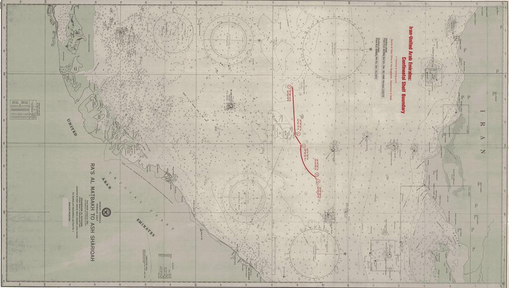
3 2 The Imperial Government of Iran and the Government of the State of the United Arab Emirates (Dubai) signed an agreement on August 31, 1974, regarding the delimitation of their continental shelf boundary. The agreement was ratified by Iran on March 15, 1975, but it has yet to be ratified by the U.A.E. Neither government is a party to the 1958 Geneva Convention on the Continental Shelf. The Agreement Concerning the Boundary Line Dividing Parts of the Continental Shelf Between Iran and the United Arab Emirates states that: The Government of the State of U.A.E. and the Imperial Government of Iran desirous of establishing in a just, equitable and precise manner the boundary line between the respective areas of continental shelf over which they have sovereign rights in accordance with international law. Have agreed as follows: Article 1 The boundary line dividing the continental shelf lying between the territory of U.A.E. on one side and that of Iran on the other side, except in the vicinity of Sirri Island, shall consist of geodetic lines between the following points: Point 1: 54º05'16" long. East 25º38'13" lat. North to Point 2: 54º26'18" long. East 25º39'55" lat. North to Point 3: 54º30'25" long. East 25º41'35" lat. North From this point the boundary line coincides with the southern 12-mile limit of the territorial waters of the Sirri Island: to Point 4: 54º44'50" long. East 25º47'20" lat. North to Point 5: 54º45'07" long. East 25º47'30" lat. North Article 2 If any single geological Petroleum structure or Petroleum field, or any single geological structure or field of any other mineral deposit extends across the boundary line set out in Article (1) of this Agreement and the part of such structure of field which is situated on one side of that Boundary line could be exploited wholly or in part by directional drilling from the other side of the Boundary line then: (a) No well shall be drilled on either side of the Boundary line as set out in Article (1) so that any producing section thereof is less than 125 meters from the said Boundary line, except by mutual agreement between the two Governments. (b) Both Governments shall endeavour to reach agreement as to the manner in which the operations on both sides of the Boundary line could be coordinated or unitized. The Geographer Office of the Geographer Bureau of Intelligence and Research
4 3 Article 3 The Boundary line referred to in Article (1) herein has been illustrated on the British Admiralty Chart No: 2837 which is annexed to this Agreement. Article 4 Nothing in this Agreement shall affect the status of the superajacent [sic] waters or airspace above any party of the Continental Shelf. Article 5 (a) This Agreement shall be ratified and the instruments of ratification shall be exchanged at.as soon as possible. (b) This Agreement shall enter into force on the date of the exchange of instruments of ratification. In witness thereof the undersigned being duly authorized by their respective Governments, have signed the present Agreement. Done in duplicate at Tehran the 24 Rajah 1394 corresponding to the 13 August 1974 in the Arabic, Persian, and English languages, all texts being equally authoritative. For the State of U.A.E. For the Imperial Government of Iran ANALYSIS The continental shelf boundary between Iran and the U.A.E. was plotted on U.S. Naval Oceanographic Charts and 62400, The boundary extends for a distance of nautical miles and it has five turning or terminal points. The distances between points 1-2, 2-3, 3-4, and 4-5 are n. miles, 4.60 n. miles, n. miles, and 1.18 n. miles respectively. The depth of the water in this area of the Persian Gulf is approximately 30 fathoms (54.9 meters). The boundary is not based on the equidistance principle; from four of the five turning or terminal points the boundary is nearer to the Irani Island of Sirri than to any U.A.E. territory. From point 3-4 the shelf boundary coincides with Sirri's 12-nautical-mile territorial sea (the.22 n. mile discrepancy found when measuring the territorial sea--refer to the table--may be a result of the particular chart or projection used).
5 4 Even though the Dubai Government was the principal emirate involved in this treaty, most of the boundary is closer to the coasts of other emirates. The U.A.E. territory closest to points 1 and 2 is the island of Sir Abu Nu ' ayr which belongs to Sharjah. The island of Abu Musa, closest to points 3, 4, and 5 is currently in dispute between Iran and Sharjah. Disregarding Abu Musa, points 3 and 5 are closest to Sharjah (30.79 and n. miles respectively) while point 4 is closest to Dubai (42.48 n. miles). The continental shelf boundary does not coincide with the lateral limits of Dubai's legal continental shelf. The eastward limit of Dubai's legal shelf extends at a 310.5º azimuth from the Abu Hayl Peninsula to approximately the location of point 4 on the Iran-U.A.E. shelf boundary. The westward limit of Dubai's legal shelf extends at a 314.5º azimuth from the coast near Ra 's Hasan to a point approximately 1.9 nautical miles east from point 1 on the Iran-U.A.E. boundary.
6 5 PHYSICAL CHARACTERISTICS OF THE IRAN-U.A.E. CONTINENTAL SHELF BOUNDARY Terminal Distance Iran Territory Distance, Land to U.A.E. Territory or Between Boundary Point Turning Points (n.m.) points (n.m.) 1 Sirri Sir Abu Nu'ayr (Sharjah) Sirri Sir Abu Nu'ayr (Sharjah) Sirri Sir Abu Nu'ayr (Sharjah) Abu Musa (Disputed) 4 Sirri Mainland (Dubai) Abu Musa (Disputed) 5 Sirri Mainland (Sharjah) Abu Musa (Disputed)
7
International Boundary Study
 International Boundary Study Series A Limits in the Seas No. 1 January 21, 1970 Indonesia Malaysia Continental Shelf Boundary (Country Codes: ID-MY) The Geographer Office of the Geographer Bureau of Intelligence
Limits in the Seas. No. 96 June 6, Greece Italy. Continental Shelf Boundary. (Country Codes: GR-IT)
") Limits in the Seas No. 96 June 6, 1982 Greece Italy Continental Shelf Boundary (Country Codes: GR-IT) The Geographer Office of the Geographer Bureau of Intelligence and Research INTERNATIONAL BOUNDARY
Limits in the Seas No. 96 June 6, 1982 Greece Italy Continental Shelf Boundary (Country Codes: GR-IT) The Geographer Office of the Geographer Bureau of Intelligence and Research INTERNATIONAL BOUNDARY
This Book Belonged to
 THE AMERICAN UNIVERSITY Washington College of Law Library This Book Belonged to The Private Collection of Judge Richard R, Baxter I THE AMERICAN UNIVERSITY Washington College of Law Law Library W-, D.C.
Mindful of the interests which the Parties share as immediate neighbours, and in a spirit of cooperation, friendship and goodwill; and
 page 1 Delimitation Treaties Infobase accessed on 13/03/2002 Treaty between the Government of Australia and the Government of the Republic of Indonesia establishing an exclusive economic zone boundary
EXECUTIVE SUMMARY A SUBMISSION OF DATA AND INFORMATION ON THE OUTER LIMITS OF THE CONTINENTAL SHELF OF THE REPUBLIC OF NIGERIA PURSUANT TO
 EXECUTIVE SUMMARY A SUBMISSION OF DATA AND INFORMATION ON THE OUTER LIMITS OF THE CONTINENTAL SHELF OF THE REPUBLIC OF NIGERIA PURSUANT TO PART VI OF AND ANNEX II TO THE UNITED NATIONS CONVENTION ON THE
United States Department of State Bureau of Intelligence and Research. 'Limits in the Seas. No. 94 CONTINENTAL SHELF BOUNDARIES: THE PERSIAN GULF
 United States Department of State Bureau of Intelligence and Research 'Limits in the Seas d No. 94 CONTINENTAL SHELF BOUNDARIES: THE PERSIAN GULF This paper is one of a serres issued by The Geographer,
OUTER CONTINENTAL SHELF CLAIMS IN THE ARCTIC. Presentation given by Dr. Kamrul Hossain ASA University Bangladesh 15 March 2010
 OUTER CONTINENTAL SHELF CLAIMS IN THE ARCTIC Presentation given by Dr. Kamrul Hossain ASA University Bangladesh 15 March 2010 Contents Historical background of the continental shelf Concept of continental
CONFERENCE OF PARLIAMENTARIANS OF THE ARCTIC REGION. UN LOS Convention and the extended continental shelf in the Arctic
 CONFERENCE OF PARLIAMENTARIANS OF THE ARCTIC REGION UN LOS Convention and the extended continental shelf in the Arctic Presentation given by Dr. Kamrul Hossain Finnish Parliament 18 November 2009 Contents
No. 2009/9 3 February Maritime Delimitation in the Black Sea (Romania v. Ukraine)
") INTERNATIONAL COURT OF JUSTICE Peace Palace, Carnegieplein 2, 2517 KJ The Hague, Netherlands Tel.: +31 (0)70 302 2323 Fax: +31 (0)70 364 9928 Website: www.icj-cij.org Press Release Unofficial No. 2009/9
INTERNATIONAL COURT OF JUSTICE Peace Palace, Carnegieplein 2, 2517 KJ The Hague, Netherlands Tel.: +31 (0)70 302 2323 Fax: +31 (0)70 364 9928 Website: www.icj-cij.org Press Release Unofficial No. 2009/9
No Authentic texts: English and French. Registered by the United Kingdom of Great Britain and Northern Ireland on 31 May 1983.
 No. 21923 UNITED KINGDOM OF GREAT BRITAIN AND NORTHERN IRELAND and FRANCE Agreement relating to the delimitation of the continental shelf in the area east of 30 minutes west of the Greenwich Meridian (with
INTERNATIONAL BOUNDARY STUDY. Series A LIMITS IN THE SEAS. No. 15 MALAGASY REPUBLIC'STRAZGHT BASELINES. The Geographer
 x, :hi,l54 tr45 no 15 This paper is one of a series issued by The Geographer, Bureau of Intelligence and Research of the Department of State. The aim is to set forth the basis for national arrangements
EXECUTIVE SUMMARY A PARTIAL SUBMISSION OF DATA AND INFORMATION ON THE OUTER LIMITS OF THE CONTINENTAL SHELF OF THE KINGDOM OF TONGA PURSUANT TO
 EXECUTIVE SUMMARY A PARTIAL SUBMISSION OF DATA AND INFORMATION ON THE OUTER LIMITS OF THE CONTINENTAL SHELF OF THE KINGDOM OF TONGA PURSUANT TO PART VI OF AND ANNEX II TO THE UNITED NATIONS CONVENTION
Law of the Sea Symposium, February, 2016, TOKYO International Law for the Resources of the Sea
 Law of the Sea Symposium, 16-17 February, 2016, TOKYO International Law for the Resources of the Sea Segment 2 Governance of Resources of the Continental Shelf (including extended continental shelf) Introduction
CONTINENTAL SHELF SUBMISSION OF ANGOLA - EXECUTIVE SUMMARY -
 CONTINENTAL SHELF SUBMISSION OF ANGOLA - EXECUTIVE SUMMARY - INDEX List of Figures 2 List of Tables 3 1 Introduction 5 2 Provisions of Article 76 7 3 Angolan Institutions responsible for the Submission
Tore Henriksen a & Geir Ulfstein b a Faculty of Law, University of Tromsø, Tromsø, Norway. Available online: 18 Feb 2011
 This article was downloaded by: [Bibliotheek van het Vredespaleis] On: 03 May 2012, At: 03:44 Publisher: Taylor & Francis Informa Ltd Registered in England and Wales Registered Number: 1072954 Registered
Delimitation of the continental shelf beyond 200 M in the light of recent case law
 Delimitation of the continental shelf beyond 200 M in the light of recent case law K.G. Jebsen Centre for the Law of the Sea Centre Days Workshop 23 September 2014 Session 2 Alex G. Oude Elferink K.G.
Boundaries and Borders
 Political Geography Origins: Antecedent Boundaries and Borders Existed in prehistoric times Usually align with physical boundaries Pyrenees between France/Spain Cultural linguistic borders between Germanic
International Boundary Study. Libya Niger Boundary
 International Boundary Study No. 2 May 4, 1961 Libya Niger Boundary (Country Codes: LY-NG) The Geographer Office of the Geographer Bureau of Intelligence and Research INTERNATIONAL BOUNDARY STUDY No. 2
MAPS AND COORDINATES...
 Table of Contents 1 INTRODUCTION... 2 2 MAPS AND COORDINATES... 3 3 ADVISORY ASSISTANCE FROM COMMISSION MEMBERS... 3 4 PROVISIONS OF ARTICLE 76 INVOKED... 3 5 OUTSTANDING MARITIME DELIMITATIONS... 4 6
When the Earth Was Flat. Measurements were made using a plumb bob, a spirit level, and a stick. Also, the Stars.
 ABSTRACT Defining the shape of the Earth geoid. Mathematical models spheroid or ellipsoid Mathematical projection of geodetic systems GIS/GPS technology The need for a unified projection systems World
2. Law No. 6 of 1996 on Indonesian Waters (State Gazette of 1996 No. 73, Additional State Gazette of the Republic of Indonesia No.
 Government Reiplatlon No. 61 of 1998 on the list of ~eomaphical - - coordinates of the base DO& of the archi~la~ic baselines of Indonesia in the The President of the Republic of Indonesia Considering:
Sam Bateman and. State Practice Regarding Straight Baselines In East Asia Legal, Technical and Political Issues in a
 State Practice Regarding Straight Baselines In East Asia Legal, Technical and Political Issues in a Changing Environment Sam Bateman and Clive Schofield The Australian National Centre for Ocean Resources
ITLOS s approach to the delimitation of the continental shelf beyond 200 M in Bangladesh/Myanmar: Theoretical and practical difficulties
 ITLOS s approach to the delimitation of the continental shelf beyond 200 M in Bangladesh/Myanmar: Theoretical and practical difficulties London International Boundary Conference 18-19 April 2013 Panel
REPUBLIC OF THE MARSHALL ISLANDS MARITIME ZONES DECLARATION ACT 2016.
 Republic of the Marshall Islands Maritime Zones Declaration Act 2016. 33MIRCCh.1Index TITLE 33 - MARINE ZONES AND PROTECTION OF MAMMALS CHAPTER 1 - MARITIME ZONE DECLARATION s Republic of the Marshall
Legal Interpretation of Submarine Ridges & Submarine Elevations
 Legal Interpretation of Ridges & Article 76, paragraph 6 New Knowledge and Changing Circumstances in the Law of the Sea Reykjavik, Iceland June 28, 2018 Kevin Baumert U.S. Department of State U.S. ECS
Article 76, variations in annotation and implementation seen in submission documents for the claim of Extended Continental Shelf
 Article 76, variations in annotation and implementation seen in submission documents for the claim of Extended Continental Shelf Mr. Shin Tani Chairman, IHO/IAG Advisory Board on the Law of the Sea (ABLOS)
1982 United Nations Convention on the Law of the Sea
 1982 United Nations Convention on the Law of the Sea Article 16, 47, 75, 76 and 84 Article 16, 47, 75, 76 and 84 require Coastal States to deposit geographic information pertaining to their maritime limits
Preliminary Information Indicative of the Outer Limits of the Continental Shelf Beyond 200 Nautical Miles of the People s Republic of China
 (Translation) Preliminary Information Indicative of the Outer Limits of the Continental Shelf Beyond 200 Nautical Miles of the People s Republic of China 1. The People s Republic of China ratified the
SIXTH REGULAR SESSION, 2017 C.B. NO A BILL FOR AN ACT
 NINETEENTH CONGRESS OF THE FEDERATED STATES OF MICRONESIA SIXTH REGULAR SESSION, 0 C.B. NO. - A BILL FOR AN ACT To amend title of the code of the Federated States of Micronesia by amending existing sections
How to Deal with Maritime Boundary Uncertainty in Oil and Gas Exploration and Production Areas*
 The University of Texas School of Law Presented: International Upstream Energy Transactions January 17-18, 2013 Houston, TX How to Deal with Maritime Boundary Uncertainty in Oil and Gas Exploration and
JOINT SUBMISSION TO THE COMMISSION ON THE LIMITS OF THE CONTINENTAL SHELF BY TUVALU, THE REPUBLIC OF FRANCE AND NEW ZEALAND (TOKELAU)
") JOINT SUBMISSION TO THE COMMISSION ON THE LIMITS OF THE CONTINENTAL SHELF BY TUVALU, THE REPUBLIC OF FRANCE AND NEW ZEALAND (TOKELAU) TABLE OF CONTENTS i. PREFACE... iii ii. LIST OF FIGURES... iv iii.
JOINT SUBMISSION TO THE COMMISSION ON THE LIMITS OF THE CONTINENTAL SHELF BY TUVALU, THE REPUBLIC OF FRANCE AND NEW ZEALAND (TOKELAU) TABLE OF CONTENTS i. PREFACE... iii ii. LIST OF FIGURES... iv iii.
xxv PART I THE DIVIDED OCEANS: INTERNATIONAL LAW GOVERNING JURISDICTIONAL ZONES 1
 Contents Preface page xv List of Figures xvii List of Tables xviii List of Abbreviations xix Table of Cases xxi Table of Treaties and Instruments xxv PART I THE DIVIDED OCEANS: INTERNATIONAL LAW GOVERNING
Indonesia s Internal Maritime Boundaries
 University of Wollongong-Lecture in Boundaries, November 2005 Indonesia s Internal Maritime Boundaries 1 Lecture Outline Indonesia's internal maritime boundaries Law no. 22/1999 --> Law no. 32/2004 Technical
J~ crntiolia/ h'i ary Studg
 J~ crntiolia/ h'i ary Studg SERIES A A VY, El.ECTE 'l BUREAU OF INTELLIGENCE AND RESEARCH 174 ~MARCH 14, 1-9Yt 09 ISSUED BY THE GEOGRAPHER This paper is one of a series issued by The Geographer, Bureau
Law No. 41 of 1 June 1979 concerning the Territorial Sea, the Economic Zone and the Continental Shelf. I The territorial sea
 Page 1 Law No. 41 of 1 June 1979 concerning the Territorial Sea, the Economic Zone and the Continental Shelf I The territorial sea Article 1. The territorial sea of Iceland shall be delimited by a line
MARINE GEODESY. by James C. T i s o n, J r. Director, U.S. Coast and Geodetic Survey
 MARINE GEODESY by James C. T i s o n, J r. Director, U.S. Coast and Geodetic Survey Reprinted, by kind permission, from Bulletin Géodésique, being the Journal of The International Association of Geodesy,
GeomaticsWorld. Issue No 3 : Volume 21. Helping to unravel Easter Island s mysterious statues. DGI 2013: maritime security highlighted
 GeomaticsWorld MARCH APRIL 2013 Issue No 3 : Volume 21 BIM: repeat the message even if you lose the will to live Helping to unravel Easter Island s mysterious statues DGI 2013: maritime security highlighted
Regional Aspects of Maritime Boundary Delimitation in the Gulf of Guinea: current situation, challenges and possible solutions
 Regional Aspects of Maritime Boundary Delimitation in the Gulf of Guinea: current situation, challenges and possible solutions BY JUSTIN TANGA BIANG UNNIPPON ALUMNAE 20092010 INTRODUCTION (1) For the purpose
State Practice on the Establishment of Multiple Maritime Boundaries: Assessing the Challenges of Separating Seabed and Water Column Boundaries
 State Practice on the Establishment of Multiple Maritime Boundaries: Assessing the Challenges of Separating Seabed and Water Column Boundaries Professor Clive Schofield The Australian National Centre for
DELIMITATION OF THE MOZAMBIQUE MARITIME BOUNDARIES WITH NEIGHBORING STATES (INCLUDING THE EXTENDED CONTINENTAL SHELF) AND MANAGEMENT OF OCEAN ISSUES
 AND MANAGEMENT OF OCEAN ISSUES") DELIMITATION OF THE MOZAMBIQUE MARITIME BOUNDARIES WITH NEIGHBORING STATES (INCLUDING THE EXTENDED CONTINENTAL SHELF) AND MANAGEMENT OF OCEAN ISSUES Elisio B. Jamine United Nations The Nippon Fellowship
DELIMITATION OF THE MOZAMBIQUE MARITIME BOUNDARIES WITH NEIGHBORING STATES (INCLUDING THE EXTENDED CONTINENTAL SHELF) AND MANAGEMENT OF OCEAN ISSUES Elisio B. Jamine United Nations The Nippon Fellowship
HYDROGRAPHIC SECTION QATAR NATIONAL REPORT TO THE 6 TH ROPME SEA AREA HYDROGRAPHIC COMMISSION MEETING
 HYDROGRAPHIC SECTION QATAR NATIONAL REPORT TO THE 6 TH ROPME SEA AREA HYDROGRAPHIC COMMISSION MEETING ABU DHABI, UNITED ARAB EMIRATES 9 11 FEBRUARY 2015 Page left intentionally blank 1. Hydrographic Section
THE GEOGRAPHY OF A MARITIME BOUNDARY DELIMITATION. By Adam J.Kerr
 THE GEOGRAPHY OF A MARITIME BOUNDARY DELIMITATION By Adam J.Kerr Abstract. A Judgement of the International Court of Justice, dated 8 October 2007, resolved the Case Concerning Territorial and Maritime
SOLVING THE RIDGES ENIGMA OF ARTICLE 76 OF THE UNITED NATIONS CONVENTION ON THE LAW OF THE SEA. Written by: George Taft Presented by: George Taft
 SOLVING THE RIDGES ENIGMA OF ARTICLE 76 OF THE UNITED NATIONS CONVENTION ON THE LAW OF THE SEA Written by: George Taft Presented by: George Taft (The views contained herein are those of the author and
The Three Equidistance Lines in Maritime Delimitation: What and Why? By: Dany Channraksmeychhoukroth* (Aug 2015)
") The Three Equidistance Lines in Maritime Delimitation: What and Why? By: Dany Channraksmeychhoukroth* (Aug 2015) Equidistance is a common term in math defined as the equal distance from every point. Similarly,
The Three Equidistance Lines in Maritime Delimitation: What and Why? By: Dany Channraksmeychhoukroth* (Aug 2015) Equidistance is a common term in math defined as the equal distance from every point. Similarly,
Draft Presentation Carleton Conference on the Arctic Is There a Need for New Legal Regime in the Arctic?
 Draft Presentation Carleton Conference on the Arctic Is There a Need for New Legal Regime in the Arctic? Donald McRae, University of Ottawa The climatic changes affecting the Arctic have lead to visions
file:///c:/documents and Settings/kapilan/My Documents/WEB Domest...
 1 of 5 3/17/2011 1:15 PM Print Close Maritime Zones Law A LAW TO PROVIDE FOR THE DECLARATION OF THE TERRITORIAL SEA AND OTHER MARITIME ZONES OF SRI LANKA, AND ALL OTHER MATTERS CONNECTED THEREWITH OR INCIDENTAL
Maritime delimitation and environmental protection of fragile seas
 Gemma Andreone Istituto di Studi Giuridici Internazionali - Consiglio Nazionale delle Ricerche Marsafenet Cost Action Chair - www.marsafenet.org Maritime delimitation and environmental protection of fragile
UNCLOS Delimitations
 A Member of the ACRI Group UNCLOS Delimitations IAGCIOGP-Joint-HSSE-Security-Forum 29th of September 2016 1/51 Foreword ARGANS Ltd. is a British SME specialised in Earth Observation by Remote Sensing.
Ocean Governance and the Japanese Basic Act on Ocean Policy
 Ocean Governance and the Japanese Basic Act on Ocean Policy Hiroshi Terashima Executive Director Ocean Policy Research Foundation 14 April 2009 The United Nations Nippon Foundation Fellowship Programme
Maritime Boundary Negotiations National Considerations Dr. Robert W. Smith
 Maritime Boundary Negotiations National Considerations Dr. Robert W. Smith ABLOS: ADDRESSING DIFFICULT ISSUES IN UNCLOS 28 OCTOBER 2003 Practical Steps in the Negotiating Process 1. The Delimitation Process
Outer Continental Shelf
 The Delimitation of the Outer Continental Shelf Presentation by Stephen Fietta Monaco, 17 October 2008 Latham & Watkins is the business name of Latham & Watkins (London) LLP, a registered limited liability
Preliminary Information Indicative of the outer limits of the continental shelf And Description of the status of preparation of making a submission
 Preliminary Information Indicative of the outer limits of the continental shelf And Description of the status of preparation of making a submission To the Commission on the Limits of the Continental Shelf
Pacific Islands Regional Maritime Boundaries Project
 Pacific Islands Regional Maritime Boundaries Project 31 st Star Conference, Nadi, FIJI 6-8 June 2016 Jens Kruger Head of Ocean & Coastal Geoscience Sector Andrick Lal Project Officer (Surveying) Emily
Some Thoughts on Maritime Delimitation among the Northeast Asian States
 Some Thoughts on Maritime Delimitation among the Northeast Asian States Seokwoo LEE Assistant Professor College of Law INHA University Korea leeseokwoo@inha.ac.kr 1 I. Common geographical features II.
The Outer Space Treaty of 1967 Preamble
 0 0 The Outer Space Treaty of Preamble Treaty on principles governing the activities of states in the exploration and use of outer space, including the moon and other celestial bodies. Opened for signature
Background Information
 Oceanography LAB #1: Marine Charts and Navigation Background Information Latitude and Longitude A coordinate is an address a means of designating location. Most coordinate systems involve a network of
The Continental Shelf North of the Faroe Islands
 Partial Submission of the Government of the Kingdom of Denmark together with the Government of the Faroes to the Commission on the Limits of the Continental Shelf The Continental Shelf North of the Faroe
Briefing document of the status of maritime boundaries in Pacific island countries
 Secretariat of the Pacific Community Seventh Heads of Fisheries Meeting (28 Feb. 4 March 2011, Noumea, New Caledonia) Working Paper 5 Original: English Briefing document of the status of maritime boundaries
Maritime Boundary Issues Singapore Workshop: Session 4
 Maritime Boundary Issues Singapore Workshop: Session 4 How States deal with factors that can affect boundary negotiations Dr. Robert W. Smith Independent Geographic Consultant U.S. Department of State
Geodetic Datum of Indonesian Maritime Boundaries: Status and Problems
 Geodetic Datum of Indonesian Maritime Boundaries: Status and Problems Hasanuddin Z. ABIDIN, Sobar SUTISNA, T. PADMASARI, J. KAHAR and Klaas J. VILLANUEVA, Indonesia Key words: Indonesia, Geodetic Datum,
Clive Schofield * and David Freestone **
 Holding Back the Waves: Options to Secure Maritime Jurisdictional Claims in the Face of Sea Level Rise Clive Schofield * and David Freestone ** *Australian National Centre for Ocean Resources and Security
THE INTERNATIONAL HYDROGRAPHIC ORGANIZATION AND ITS INVOLVEMENT WITH GEOGRAPHICAL PLACE NAMES
 International Hydrographie Review, Monaco, LXXV(1), March 1998 THE INTERNATIONAL HYDROGRAPHIC ORGANIZATION AND ITS INVOLVEMENT WITH GEOGRAPHICAL PLACE NAMES by Adam J. KERR' INTRODUCTION It may be useful
The Relevance of Hydrography to UNCLOS; an Indonesian Perspective By: Prof. Dr. Hasjim Djalal, MA*
 The Relevance of Hydrography to UNCLOS; an Indonesian Perspective By: Prof. Dr. Hasjim Djalal, MA* As I understand it, the theme of this 6 th ABLOS Conference 2010 is Contentious Issues in UNCLOS- surely
The map document opens, and you see a physical map of the world with the Saudi Arabian Peninsula outlined in red.
 Module 5, Lesson 2 A line in the sand The ever-changing map of the world reflects the forces of conflict and cooperation among nations and peoples of the world. In this activity, you will explore one of
DRAFT TREATY GOVERNING THE ACTIVITIES OF STATES ON THE CELESTIAL BODIES OF THE SOLAR SYSTEM OPSA Proposed by Thomas Gangale, OPS-Alaska 2014
 DRAFT TREATY GOVERNING THE ACTIVITIES OF STATES ON THE CELESTIAL BODIES OF THE SOLAR SYSTEM OPSA-2014-02 Proposed by Thomas Gangale, OPS-Alaska 2014 The States Parties to this Treaty, Noting the achievements
Integrated Hydrodynamic Modeling System
 Integrated Hydrodynamic Modeling System Applied Science Associates, Inc. 70 Dean Knauss Drive Narragansett, RI USA 02882 www.asascience.com support@asascience.com 1 Introduction HYDROMAP is a globally
INTERNATIONAL CONVENTION FOR THE CONTROL AND MANAGEMENT OF SHIPS' BALLAST WATER AND SEDIMENTS, 2004
 E 4 ALBERT EMBANKMENT LONDON SE1 7SR Telephone: +44 (0)20 7735 7611 Fax: +44 (0)20 7587 3210 BWM.2/Circ.56 13 July 2015 INTERNATIONAL CONVENTION FOR THE CONTROL AND MANAGEMENT OF SHIPS' BALLAST WATER AND
Chapter 12: Pacific Realm and Polar Futures
 Geography: Realms, Regions and Concepts 15 th Edition By de Blij and Muller Chapter 12: Pacific Realm and Polar Futures Defining the Realm Sea Hemisphere: seas covering nearly an entire hemisphere Fragmented,
Sharing the Resources of the South China Sea
 Sharing the Resources of the South China Sea MARK J. VALENCIA Senior Fellow, East-West Center, Honolulu, Hawaii, U.SA. JON M. VAN DYKE Professor oflaw, Wm. S. Richardson School oflaw, University of Hawaii,
A Boundary Delineation System for the Bureau of Ocean Energy Management
 A Boundary Delineation System for the Bureau of Ocean Energy Management Doug Vandegraft Chief, Mapping and Boundary Branch BOEM Coastal Geotools - 2015 Outline Introduction BOEM Marine Cadastre Background
The Southern Continental Shelf of Greenland
 Partial Submission of the Government of the Kingdom of Denmark together with the Government of Greenland to the Commission on the Limits of the Continental Shelf The Southern Continental Shelf of Greenland
Barry Lawrence Ruderman Antique Maps Inc.
 Map Maker: Melish Date: 1818 Place: Philadelphia Color: Hand Colored Condition: VG Size: 57 x 36 inches Price: $65,000.00 Description: The Adams Onis Treaty Edition of The Most Important Map of the United
Slide 1 Geography: Realms, Regions, and Concepts 15 th Edition. Slide 2. Slide 3 Defining the Realm. Chapter 12: Pacific Realm and Polar Futures
 Slide 1 Geography: Realms, Regions, and Concepts 15 th Edition Chapter 12: Pacific Realm and Polar Futures Slide 2 Slide 3 Defining the Realm Sea Hemisphere: seas cover nearly an entire hemisphere: Fragmented,
Captain J. Ashley Roach, JAGC, USN (retired) Office of the Legal Adviser U.S. Department of State (retired) Visiting Senior Principal Research Fellow
 Office of the Legal Adviser U.S. Department of State (retired) Visiting Senior Principal Research Fellow") Captain J. Ashley Roach, JAGC, USN (retired) Office of the Legal Adviser U.S. Department of State (retired) Visiting Senior Principal Research Fellow Centre for International Law NUS Singapore SCS Award
Captain J. Ashley Roach, JAGC, USN (retired) Office of the Legal Adviser U.S. Department of State (retired) Visiting Senior Principal Research Fellow Centre for International Law NUS Singapore SCS Award
Maritime Boundary Delimitation: Recent ICJ Jurisprudence Nicaragua v Colombia; Peru v Chile
 Maritime Boundary Delimitation: Recent ICJ Jurisprudence Nicaragua v Colombia; Peru v Chile May 28, 2014 Prof. Seokwoo LEE Inha University Law School leeseokwoo@inha.ac.kr 1 Recent Developments The Black
The Place of Joint Development in the Sustainable Arctic Governance
 The Place of Joint Development in the Sustainable Arctic Governance ShipArc2015: Joint WMU - IMO - Arctic Council International Conference on Safe and Sustainable Shipping in a Changing Arctic Environment
Legal Implications for Delimitation of Airspace and Outer Space
 Legal Implications for Delimitation of Airspace and Outer Space Prof. Joanne Irene Gabrynowicz IISL/ECSL Symposium at the Legal Subcommittee of the Committee on the Peaceful Uses of Outer Space 28 March
Laurier Centre for Military Strategic and Disarmament Studies
 Laurier Centre for Military Strategic and Disarmament Studies Finding Aid - (MG-0036) Generated by Access to Memory (AtoM) 2.3.1 Printed: August 24, 2017 Language of description: English Laurier Centre
Outline 16: The Mesozoic World: Formation of Oil Deposits (with a side trip to the Devonian Marcellus Shale)
") Outline 16: The Mesozoic World: Formation of Oil Deposits (with a side trip to the Devonian Marcellus Shale) The first commercial oil well was drilled by Colonel Edwin Drake in Titusville, Pennsylvania,
Outline 16: The Mesozoic World: Formation of Oil Deposits (with a side trip to the Devonian Marcellus Shale) The first commercial oil well was drilled by Colonel Edwin Drake in Titusville, Pennsylvania,
Polar complications in the law of the sea: A case study of the regime for research and survey activities in the Arctic Ocean
 2010 ABLOS Conference: Contentious Issues in UNCLOS Surely Not? International Hydrographic Bureau, 25-27 October 2010 Polar complications in the law of the sea: A case study of the regime for research
INTERNATIONAL HYDROGRAPHIC ORGANIZATION
 INRNATIONAL HYDROGRAPHIC ORGANIZATION Maritime Limits and Boundaries Product Specification IHO S-121 Version 1.0 April 2014 Maritime Limits and Boundaries Product Specification Published by the International
IRELAND. PART I Executive Summary
 IRELAND Submission to the Commission on the Limits of the Continental Shelf pursuant to Article 76, paragraph 8 of the United Nations Convention on the Law of the Sea 1982 in respect of the area abutting
UNDERSEA FEATURE NAME PROPOSAL (See IHO-IOC Publication B-6 and NOTE overleaf)
") INTERNATIONAL HYDROGRAPHIC ORGANIZATION INTERGOVERNMENTAL OCEANOGRAPHIC COMMISSION (of UNESCO) Note: The boxes will expand as you fill the form. UNDERSEA FEATURE NAME PROPOSAL (See IHO-IOC Publication
INTERNATIONAL HYDROGRAPHIC ORGANIZATION INTERGOVERNMENTAL OCEANOGRAPHIC COMMISSION (of UNESCO) Note: The boxes will expand as you fill the form. UNDERSEA FEATURE NAME PROPOSAL (See IHO-IOC Publication
The application of international law principle in practice of the delimitation on continental shelf
 World Maritime University The Maritime Commons: Digital Repository of the World Maritime University World Maritime University Dissertations Dissertations 2013 The application of international law principle
Produced by Canadian Ice Service of. 2 December Seasonal Outlook Gulf of St Lawrence and East Newfoundland Waters Winter
 Environment Canada Environnement Canada Produced by Canadian Ice Service of Environment Canada 2 December 2010 Seasonal Outlook Gulf of St Lawrence and East Newfoundland Waters Winter 2010-2011 2010 Canadian
Economic and Social Council
 United Nations Economic and Social Council Distr.: General 25 May 2012 Original: English E/CONF.101/113 Tenth United Nations Conference on the Standardization of Geographical Names New York, 31 July 9
2013 No MARINE MANAGEMENT. The Exclusive Economic Zone Order 2013
 S T A T U T O R Y I N S T R U M E N T S 2013 No. 3161 MARINE MANAGEMENT The Exclusive Economic Zone Order 2013 Made - - - - 11th December 2013 Laid before Parliament 18th December 2013 Coming into force
E/CONF.105/115/CRP.115***
 E/CONF.105/115/CRP.115*** 30 June 2017 Original: English 11 th United Nations Conference on the Standardization of Geographical Names New York, 8-17 August 2017 Item 9a) of the provisional agenda* National
API 4F, 4th Edition, Purchasing Guideline
 The following information should be provided by the purchaser when making an inquiry or placing an order: a) Reference to this standard; b) Reference to any requirement for third party certification, name
UNCLOS Article 76- Formulae and constraint lines
 UNCLOS Article 76- Formulae and constraint lines Dr Lindsay Parson (UNCLOS Group, National Oceanography Centre, UK) ABLOS TUTORIAL SESSION - Article 76 of UNCLOS 10th October 2005 IHO/IAG/IOC Advisory
Center of valley versus Thalweg: Revisiting the Israel Jordan Aravah Boundary Dispute
 Center of valley versus Thalweg: Revisiting the Israel Jordan Aravah Boundary Dispute Maxim SHOSHANY and Haim SREBRO, Israel Key words: Israel Jordan Boundary Dispute, Aravah Valley, Boundary Definition,
The Indian Ocean. Copyright 2010 LessonSnips
 The Indian Ocean One of the five major geographic divisions of the world s ocean, the Indian Ocean is located in the Eastern Hemisphere. The Indian Ocean is bounded by three continents: Africa to the west,
Underwater Parks: Three Case Studies, and a Primer on Marine Boundary Issues. Robert E. Johnson Leland F. Thormahlen
 Robert E. Johnson Leland F. Thormahlen Underwater Parks: Three Case Studies, and a Primer on Marine Boundary Issues Unlike boundaries on land, most marine boundaries are not marked with monuments or fences.
The Geography of a Maritime Boundary Delimitation
 The Geography of a Maritime Boundary Delimitation By Adam J. Kerr (UK) A b s tra c ts A Judgment of the International Court of Justice, dated 8 October 2007, resolved the Case Concerning Territorial and
Timor Sea Maritime Boundaries: a presentation for the ICJA/ILA Colloquium at University of New South Wales 16 August 2014
 Timor Sea Maritime Boundaries: a presentation for the ICJA/ILA Colloquium at University of New South Wales 16 August 2014 Contents: 1. History of Treaties 2. Assessing selected boundary proposals 3. Commentary
North Sea Ballast Water Exchange Area
 HELSINKI and OSPAR COMMISSIONS HELCOM/OSPAR TG BALLAST 8-2017 Joint HELCOM/OSPAR Task Group on Ballast Water Management Convention Exemptions Eighth Meeting Helsinki, Finland, 16-17 November 2017 Document
Linking Global and Regional Levels in the Management of Marine Areas Beyond National Jurisdiction
 Linking Global and Regional Levels in the Management of Marine Areas Beyond National Jurisdiction South Atlantic Region Session 4: «Experiences, Priorities and Opportunities in the South Atlantic and Indian
ANNEX 23 RESOLUTION MSC.231(82) ADOPTION OF AMENDMENTS TO THE EXISTING MANDATORY SHIP REPORTING SYSTEM IN THE GULF OF FINLAND
 ADOPTION OF AMENDMENTS TO THE EXISTING MANDATORY SHIP REPORTING SYSTEM IN THE GULF OF FINLAND") RESOLUTION MSC.231(82) (adopted on 5 December 2006) ADOPTION OF AMENDMENTS TO THE EXISTING MANDATORY SHIP REPORTING SYSTEM IN THE GULF OF FINLAND THE MARITIME SAFETY COMMITTEE, RECALLING Article 28(b)
RESOLUTION MSC.231(82) (adopted on 5 December 2006) ADOPTION OF AMENDMENTS TO THE EXISTING MANDATORY SHIP REPORTING SYSTEM IN THE GULF OF FINLAND THE MARITIME SAFETY COMMITTEE, RECALLING Article 28(b)
Regulations concerning protection of Bjørnøya Nature Reserve in Svalbard
 Regulations concerning protection of Bjørnøya Nature Reserve in Svalbard Laid down by the Royal Decree of 16 August 2002 pursuant to sections 12 and 17 of the Act of 15 June 2001 No. 79 relating to the
ARTICLE I NATIONAL TERRITORY
 ARTICLE I NATIONAL TERRITORY The national territory comprises the Philippine archipelago, with all the islands and waters embraced therein, and all other territories over which the Philippines has sovereignty