Sam Bateman and. State Practice Regarding Straight Baselines In East Asia Legal, Technical and Political Issues in a
|
|
|
- Christopher Stone
- 5 years ago
- Views:
Transcription
1 State Practice Regarding Straight Baselines In East Asia Legal, Technical and Political Issues in a Changing Environment Sam Bateman and Clive Schofield The Australian National Centre for Ocean Resources & Security (ANCORS) University of Wollongong, Australia Prepared for the Advisory Board on the Law of the Sea (ABLOS) on Difficulties In Implementing the Provisions of UNCLOS International Hydrographic Bureau Monaco, October 2008
2 Importance of Baselines Fundamental to maritime claims Define outer limits of internal waters Starting ti point for claiming i maritime zones Provide basepoints for generation of limits of national maritime claims
3 Importance of Baselines Fundamental to maritime boundary delimitation Determine basepoints for construction ti of median line Median line often starting point for delimitation Presumption in favour of equidistance line in territorial sea delimitation (Article 15) Majority of maritime boundary agreements wholly or partially based on equidistance
4 Normal Baselines Geneva Convention on the Territorial Sea and the Contiguous Zone, Article 3 LOSC, Article 5 Article 5 of the LOSC states: Except where otherwise provided in this Convention, the normal baseline for measuring the breadth of the territorial sea is the low-water line along the coast as marked on large-scale charts officially recognised by the coastal State.
5 Straight Baselines: The United Kingdom vs. Norway ICJ Case Norway claimed straight baselines along its northern coast from 1935 Four nautical mile fishery zone claimed from straight baselines UK fishing vessels arrested in extra fishery zone claimed UK brought case before ICJ against Norway in 1949 Judgment in 1951
6
7 The ICJ s 1951 Judgment The ICJ found in favour of Norway, stating that: Where a coast is deeply indented and cut into or where it is bordered by an archipelago such as the skjaergaard along the western sector of the coast Such a coast, viewed as a whole, calls for the application of a different method; that is, the method of base-lines which within reasonable limits, may depart from the physical line of the coast. Judgment therefore fundamental to the introduction of the straight baselines concept Led directly to the drafting of Article 4 of Geneva Convention and hence Article 7 of the UN Convention
8 Intentions of Article 7 Cater for unusual coastal geography Avoid situations where normal/bay closing lines result in enclaves of non-territorial i sea Avoid complex mosaic of territorial i sea and non-territorial sea areas Simplify marine management
9 0 nm 24 0 nm 24 New territorial sea limit Source: United Nations, 1989
10 Straight Baselines Geneva Convention on the Territorial Sea and the Contiguous Zone, Article 4 LOSC, Article 7 1. In localities where the coastline is deeply indented and cut into, or if there is a fringe of islands along the coast in its immediate vicinity, the method of straight baselines joining appropriate points may be employed in drawing the baseline from which the breadth of the territorial sea is measured. 2. Where because of the presence of a delta and other natural conditions the coastline is highly unstable, the appropriate points may be selected along the furthest seaward extent of the low water line and notwithstanding subsequent regression of the low-water line, the straight baselines shall remain effective until changed by the coastal State in accordance with this Convention. 3. The drawing of straight baselines must not depart to any appreciable extent from the general direction of the coast, and the sea areas lying within the lines must be sufficiently closely linked to the land to be subject to the regime of internal waters. 4. Straight baselines shall not be drawn to and from low-tide elevations, unless lighthouses or similar installations which are permanently above sea level have been built on them or except in instances where the drawing of baselines to and from such elevations has received general international recognition. 5. Where the method of straight baselines is applicable under paragraph 1, account may be taken, in determining particular baselines, of economic interests peculiar to the region concerned, the reality and importance of which are clearly evidenced by long usage. 6. The system of straight baselines may not be applied by a State in such a manner as to cut off the territorial sea of another State from the high seas or an exclusive economic zone.
11 Deeply indented or Fringe of Islands 1. In localities where the coastline is deeply indented and cut into, or if there is a fringe of islands along the coast in its immediate vicinity, the method of straight baselines joining appropriate points may be employed in drawing the baseline from which the breadth of the territorial sea is measured.
12 Deeply indented or Fringe of Islands 1. In localities where the coastline is deeply indented and cut into, or if there is a fringe of islands along the coast in its immediate vicinity, the method of straight baselines joining appropriate points may be employed in drawing the baseline from which the breadth of the territorial sea is measured. What constitutes a deeply indented and cut into coastline? py How is a fringe of islands defined and at what distance offshore is such a fringe of islands in the coastline s immediate vicinity? No objective tests provided US Guidelines detailed
13 General Direction of the Coast 3. The drawing of straight baselines must not depart to any appreciable extent from the general direction of the coast, and the sea areas lying within the lines must be sufficiently closely linked to the land to be subject to the regime of internal waters.
14 In sum: the imprecise language age [of Article 7] would allow any coastal country, anywhere in the world, to draw straight baselines along its coast. Prescott, 1985
15 Burma s Claimed Straight Baselines
16 The Andaman Sea Source: IBRU / Jane s Exclusive Economic Zones
17 Cambodia s Claimed Straight Baselines
18 China s Straight Baselines May 15, 1996 Declaration Paracel Islands
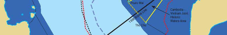
19 Segment of China s Straight Baseline System segment 8-9= 122 miles pt 9 is submerged pt. 10: LTE greater than 12 miles from mainland. China segment 10-11= 100 miles
20 China s Straight Baseline claim around the Paracel Islands Encloses 17,400km 2 Vietnam also claims sovereignty over the Paracel Islands
21 Japan s Straight Baseline Claim
22 South Korea s Straight Baselines
23 Malaysia s Inferred Straight Baselines
24 The Philippines Luzon Strait S o u t h C h i n a S e a Luzon Philippine Sea Manila P H I L I P P I N E S Palawan Sulu Sea Mindanao Davao Sabah MALAYSIA Celebes Sea INDONESIA
25 Vietnam s Claimed Straight Baselines


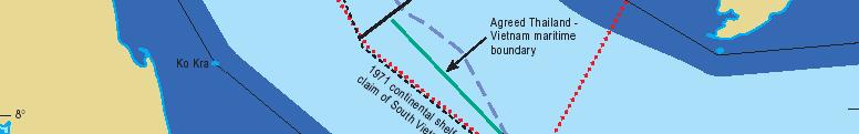

26 Gulf of Thailand Excessive baselines need not prevent the delimitation of maritime boundaries
27 Archipelagic States According to Article 46 of the LOSC an archipelagic state is one constituted wholly by one or more archipelagos but may also include other islands. Archipelagos themselves are defined in Article 46 as: a group of islands, including parts of islands, interconnecting waters and other natural features which are so closely interrelated that such islands, waters and other natural features form an intrinsic geographical, economic and political entity, or which historically have been regarded as such.
28 Global state-of-play 92 of 151 coastal States have claimed straight or archipelagic baselines along all or part of their coasts Or 61% Excessive claims?
29 Implications of Straight Baselines Claims in a Changing Environment Maritime Jurisdictional Claims International Legal Implications Maritime Boundaries Political Issues Operational Implications Oceans Management


30 Impacts on Maritime Jurisdictional Claims May increase coastal State jurisdiction Internal waters Offshore jurisdiction But situation should not be overstated Geographical realities Geographical realities of East Asia
31 Possible Advantage of Straight Baselines
32 International Legal Implications Does East Asian liberal use of straight baselines influence customary norms of international law? Arguments against: UNCLOS Article 7 very clear ICJ cases including 2001 Qatar v. Bahrain decision But some division of scholarly opinion Regional v. Global views
33 Maritime Boundary Issues Maritime boundaries very problematic in East Asia Relatively few have been agreed Straight baselines may deflect lines of equidistance Influence in some regional boundary delimitations e.g. Malaysia-Indonesia continental t shelf boundary negotiations
34 Political Issues Creeping jurisdiction by coastal State Straight baselines detract from international community s use of ocean space Balance of maritime power shifting towards East Asia Future influence of East Asia on State practice with the Law of the Sea?
35 Operational Implications Straight baselines restrict freedoms of navigation i and overflight They can complicate maritime law enforcement Place additional demands on operators Do East Asian countries strictly enforce their straight baseline claims? US Freedom of Navigation (FON) program
36 Conclusions Virtually all claimed straight baseline systems in East Asia are excessive But East Asian countries unlikely to step back from their baseline claims What can be done to resolve current situation? Scope for further research Implications for regional stability - situation might be addressed at a regional level
37 Throughout the region under review (i.e. East Asia), many more boundaries remain to be settled than have already been resolved. Further settlements are rightly regarded as no easy task. On the other hand, this cannot be indefinitely avoided by continuing the policies of some of the states in the region. (Choon-Ho Park, Central Pacific and East Asian Maritime Boundaries, p.302)
Clive Schofield * and David Freestone **
 Holding Back the Waves: Options to Secure Maritime Jurisdictional Claims in the Face of Sea Level Rise Clive Schofield * and David Freestone ** *Australian National Centre for Ocean Resources and Security
Some Thoughts on Maritime Delimitation among the Northeast Asian States
 Some Thoughts on Maritime Delimitation among the Northeast Asian States Seokwoo LEE Assistant Professor College of Law INHA University Korea leeseokwoo@inha.ac.kr 1 I. Common geographical features II.
The Relevance of Hydrography to UNCLOS; an Indonesian Perspective By: Prof. Dr. Hasjim Djalal, MA*
 The Relevance of Hydrography to UNCLOS; an Indonesian Perspective By: Prof. Dr. Hasjim Djalal, MA* As I understand it, the theme of this 6 th ABLOS Conference 2010 is Contentious Issues in UNCLOS- surely
State Practice on the Establishment of Multiple Maritime Boundaries: Assessing the Challenges of Separating Seabed and Water Column Boundaries
 State Practice on the Establishment of Multiple Maritime Boundaries: Assessing the Challenges of Separating Seabed and Water Column Boundaries Professor Clive Schofield The Australian National Centre for
REPUBLIC OF THE MARSHALL ISLANDS MARITIME ZONES DECLARATION ACT 2016.
 Republic of the Marshall Islands Maritime Zones Declaration Act 2016. 33MIRCCh.1Index TITLE 33 - MARINE ZONES AND PROTECTION OF MAMMALS CHAPTER 1 - MARITIME ZONE DECLARATION s Republic of the Marshall
xxv PART I THE DIVIDED OCEANS: INTERNATIONAL LAW GOVERNING JURISDICTIONAL ZONES 1
 Contents Preface page xv List of Figures xvii List of Tables xviii List of Abbreviations xix Table of Cases xxi Table of Treaties and Instruments xxv PART I THE DIVIDED OCEANS: INTERNATIONAL LAW GOVERNING
The Three Equidistance Lines in Maritime Delimitation: What and Why? By: Dany Channraksmeychhoukroth* (Aug 2015)
") The Three Equidistance Lines in Maritime Delimitation: What and Why? By: Dany Channraksmeychhoukroth* (Aug 2015) Equidistance is a common term in math defined as the equal distance from every point. Similarly,
The Three Equidistance Lines in Maritime Delimitation: What and Why? By: Dany Channraksmeychhoukroth* (Aug 2015) Equidistance is a common term in math defined as the equal distance from every point. Similarly,
GeomaticsWorld. Issue No 3 : Volume 21. Helping to unravel Easter Island s mysterious statues. DGI 2013: maritime security highlighted
 GeomaticsWorld MARCH APRIL 2013 Issue No 3 : Volume 21 BIM: repeat the message even if you lose the will to live Helping to unravel Easter Island s mysterious statues DGI 2013: maritime security highlighted
Maritime Boundary Negotiations National Considerations Dr. Robert W. Smith
 Maritime Boundary Negotiations National Considerations Dr. Robert W. Smith ABLOS: ADDRESSING DIFFICULT ISSUES IN UNCLOS 28 OCTOBER 2003 Practical Steps in the Negotiating Process 1. The Delimitation Process
Polar complications in the law of the sea: A case study of the regime for research and survey activities in the Arctic Ocean
 2010 ABLOS Conference: Contentious Issues in UNCLOS Surely Not? International Hydrographic Bureau, 25-27 October 2010 Polar complications in the law of the sea: A case study of the regime for research
Captain J. Ashley Roach, JAGC, USN (retired) Office of the Legal Adviser U.S. Department of State (retired) Visiting Senior Principal Research Fellow
 Office of the Legal Adviser U.S. Department of State (retired) Visiting Senior Principal Research Fellow") Captain J. Ashley Roach, JAGC, USN (retired) Office of the Legal Adviser U.S. Department of State (retired) Visiting Senior Principal Research Fellow Centre for International Law NUS Singapore SCS Award
Captain J. Ashley Roach, JAGC, USN (retired) Office of the Legal Adviser U.S. Department of State (retired) Visiting Senior Principal Research Fellow Centre for International Law NUS Singapore SCS Award
SIXTH REGULAR SESSION, 2017 C.B. NO A BILL FOR AN ACT
 NINETEENTH CONGRESS OF THE FEDERATED STATES OF MICRONESIA SIXTH REGULAR SESSION, 0 C.B. NO. - A BILL FOR AN ACT To amend title of the code of the Federated States of Micronesia by amending existing sections
Indonesia s Internal Maritime Boundaries
 University of Wollongong-Lecture in Boundaries, November 2005 Indonesia s Internal Maritime Boundaries 1 Lecture Outline Indonesia's internal maritime boundaries Law no. 22/1999 --> Law no. 32/2004 Technical
Against a rising tide: ambulatory baselines and shifting maritime limits in the face of sea level rise
 University of Wollongong Research Online Faculty of Law, Humanities and the Arts - Papers Faculty of Law, Humanities and the Arts 2009 Against a rising tide: ambulatory baselines and shifting maritime
Pacific Islands Regional Maritime Boundaries Project
 Pacific Islands Regional Maritime Boundaries Project 31 st Star Conference, Nadi, FIJI 6-8 June 2016 Jens Kruger Head of Ocean & Coastal Geoscience Sector Andrick Lal Project Officer (Surveying) Emily
Maritime Boundary Issues Singapore Workshop: Session 4
 Maritime Boundary Issues Singapore Workshop: Session 4 How States deal with factors that can affect boundary negotiations Dr. Robert W. Smith Independent Geographic Consultant U.S. Department of State
World Oceans Day 2010 Our oceans: opportunities and challenges
 World Oceans Day 2010 Our oceans: opportunities and challenges Roundtable discussion on the United Nations Convention on the Law of the Sea fifteen years after its entry into force HOW EFFECTIVELY IS UNCLOS
This Book Belonged to
 THE AMERICAN UNIVERSITY Washington College of Law Library This Book Belonged to The Private Collection of Judge Richard R, Baxter I THE AMERICAN UNIVERSITY Washington College of Law Law Library W-, D.C.
Sharing the Resources of the South China Sea
 Sharing the Resources of the South China Sea MARK J. VALENCIA Senior Fellow, East-West Center, Honolulu, Hawaii, U.SA. JON M. VAN DYKE Professor oflaw, Wm. S. Richardson School oflaw, University of Hawaii,
Chapter 12: Pacific Realm and Polar Futures
 Geography: Realms, Regions and Concepts 15 th Edition By de Blij and Muller Chapter 12: Pacific Realm and Polar Futures Defining the Realm Sea Hemisphere: seas covering nearly an entire hemisphere Fragmented,
DELIMITATION OF THE MOZAMBIQUE MARITIME BOUNDARIES WITH NEIGHBORING STATES (INCLUDING THE EXTENDED CONTINENTAL SHELF) AND MANAGEMENT OF OCEAN ISSUES
 AND MANAGEMENT OF OCEAN ISSUES") DELIMITATION OF THE MOZAMBIQUE MARITIME BOUNDARIES WITH NEIGHBORING STATES (INCLUDING THE EXTENDED CONTINENTAL SHELF) AND MANAGEMENT OF OCEAN ISSUES Elisio B. Jamine United Nations The Nippon Fellowship
DELIMITATION OF THE MOZAMBIQUE MARITIME BOUNDARIES WITH NEIGHBORING STATES (INCLUDING THE EXTENDED CONTINENTAL SHELF) AND MANAGEMENT OF OCEAN ISSUES Elisio B. Jamine United Nations The Nippon Fellowship
Delimitation of the continental shelf beyond 200 M in the light of recent case law
 Delimitation of the continental shelf beyond 200 M in the light of recent case law K.G. Jebsen Centre for the Law of the Sea Centre Days Workshop 23 September 2014 Session 2 Alex G. Oude Elferink K.G.
Maritime delimitation and environmental protection of fragile seas
 Gemma Andreone Istituto di Studi Giuridici Internazionali - Consiglio Nazionale delle Ricerche Marsafenet Cost Action Chair - www.marsafenet.org Maritime delimitation and environmental protection of fragile
CONTENTS. PREFACE AND ACKNOWLEDGEMENTS...xi ABBREVIATIONS... xiii FIGURES...xvii INTRODUCTION...1
 CONTENTS PREFACE AND ACKNOWLEDGEMENTS...xi ABBREVIATIONS... xiii FIGURES...xvii INTRODUCTION...1 CHAPTER 1 MAPS OF THE MARITIME WORLD AND LEGAL DEFINITIONS...21 1.1 Maps of the Maritime World...21 1.1.1
A National Geocentric Datum and the Administration of Marine Spaces in Malaysia 2
 A National Geocentric Datum and the Administration of Marine Spaces in Malaysia 2 CheeHai TEO 3 and Ahmad FAUZI 4 Abstract Malaysia is a country with two primary land masses, Peninsular Malaysia and East
UNCLOS Article 76- Formulae and constraint lines
 UNCLOS Article 76- Formulae and constraint lines Dr Lindsay Parson (UNCLOS Group, National Oceanography Centre, UK) ABLOS TUTORIAL SESSION - Article 76 of UNCLOS 10th October 2005 IHO/IAG/IOC Advisory
ITLOS s approach to the delimitation of the continental shelf beyond 200 M in Bangladesh/Myanmar: Theoretical and practical difficulties
 ITLOS s approach to the delimitation of the continental shelf beyond 200 M in Bangladesh/Myanmar: Theoretical and practical difficulties London International Boundary Conference 18-19 April 2013 Panel
INTERNATIONAL BOUNDARY STUDY. Series A LIMITS IN THE SEAS. No. 15 MALAGASY REPUBLIC'STRAZGHT BASELINES. The Geographer
 x, :hi,l54 tr45 no 15 This paper is one of a series issued by The Geographer, Bureau of Intelligence and Research of the Department of State. The aim is to set forth the basis for national arrangements
THE GEOGRAPHY OF A MARITIME BOUNDARY DELIMITATION. By Adam J.Kerr
 THE GEOGRAPHY OF A MARITIME BOUNDARY DELIMITATION By Adam J.Kerr Abstract. A Judgement of the International Court of Justice, dated 8 October 2007, resolved the Case Concerning Territorial and Maritime
EXECUTIVE SUMMARY A PARTIAL SUBMISSION OF DATA AND INFORMATION ON THE OUTER LIMITS OF THE CONTINENTAL SHELF OF THE KINGDOM OF TONGA PURSUANT TO
 EXECUTIVE SUMMARY A PARTIAL SUBMISSION OF DATA AND INFORMATION ON THE OUTER LIMITS OF THE CONTINENTAL SHELF OF THE KINGDOM OF TONGA PURSUANT TO PART VI OF AND ANNEX II TO THE UNITED NATIONS CONVENTION
2. Law No. 6 of 1996 on Indonesian Waters (State Gazette of 1996 No. 73, Additional State Gazette of the Republic of Indonesia No.
 Government Reiplatlon No. 61 of 1998 on the list of ~eomaphical - - coordinates of the base DO& of the archi~la~ic baselines of Indonesia in the The President of the Republic of Indonesia Considering:
Disputes Concerning the Delimitation of the Continental Shelf beyond 200 M
 Disputes Concerning the Delimitation of the Continental Shelf beyond 200 M Professor Clive Schofield Head of Research, WMU/Sasakawa Global Ocean Institute World Maritime University Sweden and Leonardo
GIS, Charts and UNCLOS Can they live together?
 GIS, Charts and UNCLOS Can they live together? Bill Hirst 1 and David Robertson 2 Address 1 Geoscience Australia GPO Box 378 Canberra, ACT 2601 Phone: 02 6249 9741 Fax: 02 6249 9939 Email: Bill.Hirst@ga.gov.au
1982 United Nations Convention on the Law of the Sea
 1982 United Nations Convention on the Law of the Sea Article 16, 47, 75, 76 and 84 Article 16, 47, 75, 76 and 84 require Coastal States to deposit geographic information pertaining to their maritime limits
Ocean Governance and the Japanese Basic Act on Ocean Policy
 Ocean Governance and the Japanese Basic Act on Ocean Policy Hiroshi Terashima Executive Director Ocean Policy Research Foundation 14 April 2009 The United Nations Nippon Foundation Fellowship Programme
Slide 1 Geography: Realms, Regions, and Concepts 15 th Edition. Slide 2. Slide 3 Defining the Realm. Chapter 12: Pacific Realm and Polar Futures
 Slide 1 Geography: Realms, Regions, and Concepts 15 th Edition Chapter 12: Pacific Realm and Polar Futures Slide 2 Slide 3 Defining the Realm Sea Hemisphere: seas cover nearly an entire hemisphere: Fragmented,
International Boundary Study
 International Boundary Study Series A Limits in the Seas No. 1 January 21, 1970 Indonesia Malaysia Continental Shelf Boundary (Country Codes: ID-MY) The Geographer Office of the Geographer Bureau of Intelligence
Briefing document of the status of maritime boundaries in Pacific island countries
 Secretariat of the Pacific Community Seventh Heads of Fisheries Meeting (28 Feb. 4 March 2011, Noumea, New Caledonia) Working Paper 5 Original: English Briefing document of the status of maritime boundaries
Underwater Parks: Three Case Studies, and a Primer on Marine Boundary Issues. Robert E. Johnson Leland F. Thormahlen
 Robert E. Johnson Leland F. Thormahlen Underwater Parks: Three Case Studies, and a Primer on Marine Boundary Issues Unlike boundaries on land, most marine boundaries are not marked with monuments or fences.
Geographical analysis in maritime boundary delimitation
 Geographical analysis in maritime boundary delimitation Martin Pratt International Boundaries Research Unit Durham University, UK 1 Abstract Nearly one third of the earth s ocean area is now under coastal
Law of the Sea Symposium, February, 2016, TOKYO International Law for the Resources of the Sea
 Law of the Sea Symposium, 16-17 February, 2016, TOKYO International Law for the Resources of the Sea Segment 2 Governance of Resources of the Continental Shelf (including extended continental shelf) Introduction
Maritime Boundary Delimitation: Recent ICJ Jurisprudence Nicaragua v Colombia; Peru v Chile
 Maritime Boundary Delimitation: Recent ICJ Jurisprudence Nicaragua v Colombia; Peru v Chile May 28, 2014 Prof. Seokwoo LEE Inha University Law School leeseokwoo@inha.ac.kr 1 Recent Developments The Black
Adapting to Sea Level Rise: A Law of the Sea Perspective
 Adapting to Sea Level Rise: A Law of the Sea Perspective Sarra Sefrioui 1 Introduction A fresh look at the latest satellite data from 2002 and 2014 shows that seas are rising by around 1.4 mm a year due
file:///c:/documents and Settings/kapilan/My Documents/WEB Domest...
 1 of 5 3/17/2011 1:15 PM Print Close Maritime Zones Law A LAW TO PROVIDE FOR THE DECLARATION OF THE TERRITORIAL SEA AND OTHER MARITIME ZONES OF SRI LANKA, AND ALL OTHER MATTERS CONNECTED THEREWITH OR INCIDENTAL
ARTICLE I NATIONAL TERRITORY
 ARTICLE I NATIONAL TERRITORY The national territory comprises the Philippine archipelago, with all the islands and waters embraced therein, and all other territories over which the Philippines has sovereignty
NOAA Nautical Charts and Coastal and Marine Spatial Planning. Meredith Westington Chief Geographer NOAA/NOS/Office of Coast Survey
 NOAA Nautical Charts and Coastal and Marine Spatial Planning Meredith Westington Chief Geographer NOAA/NOS/Office of Coast Survey Ocean Policy Task Force What is CMSP? A comprehensive, adaptive, integrated,
THE ROLE OF THE ARCHIPELAGIC BASELINES IN MARITIME BOUNDARY DELIMITATION
 THE ROLE OF THE ARCHIPELAGIC BASELINES IN MARITIME BOUNDARY DELIMITATION Sora Lokita The United Nations-Nippon Foundation Fellowship Programme 2009-2010 DIVISION FOR OCEAN AFFAIRS AND THE LAW OF THE SEA
The Contribution of Hydrographic Charting to the Resolution and Portrayal of Offshore Property and Jurisdictional Boundaries.
 The Contribution of Hydrographic Charting to the Resolution and Portrayal of Offshore Property and Jurisdictional Boundaries. Susan Nichols, Geodesy and Geomatics Engineering, University of New Brunswick
Panel III: Islands and Rocks:
 KMI, COLP, and NILOS Conference on Globalization and the Law of the Sea Panel III: Islands and Rocks: How Much Can a Rock Get? A Reflection from the Okinotorishima Rocks 1-3 December 2010 Marriot Metro
CONFERENCE OF PARLIAMENTARIANS OF THE ARCTIC REGION. UN LOS Convention and the extended continental shelf in the Arctic
 CONFERENCE OF PARLIAMENTARIANS OF THE ARCTIC REGION UN LOS Convention and the extended continental shelf in the Arctic Presentation given by Dr. Kamrul Hossain Finnish Parliament 18 November 2009 Contents
Mindful of the interests which the Parties share as immediate neighbours, and in a spirit of cooperation, friendship and goodwill; and
 page 1 Delimitation Treaties Infobase accessed on 13/03/2002 Treaty between the Government of Australia and the Government of the Republic of Indonesia establishing an exclusive economic zone boundary
EXECUTIVE SUMMARY A SUBMISSION OF DATA AND INFORMATION ON THE OUTER LIMITS OF THE CONTINENTAL SHELF OF THE REPUBLIC OF NIGERIA PURSUANT TO
 EXECUTIVE SUMMARY A SUBMISSION OF DATA AND INFORMATION ON THE OUTER LIMITS OF THE CONTINENTAL SHELF OF THE REPUBLIC OF NIGERIA PURSUANT TO PART VI OF AND ANNEX II TO THE UNITED NATIONS CONVENTION ON THE
Article 76, variations in annotation and implementation seen in submission documents for the claim of Extended Continental Shelf
 Article 76, variations in annotation and implementation seen in submission documents for the claim of Extended Continental Shelf Mr. Shin Tani Chairman, IHO/IAG Advisory Board on the Law of the Sea (ABLOS)
E/CONF.105/115/CRP.115***
 E/CONF.105/115/CRP.115*** 30 June 2017 Original: English 11 th United Nations Conference on the Standardization of Geographical Names New York, 8-17 August 2017 Item 9a) of the provisional agenda* National
MAPS AND COORDINATES...
 Table of Contents 1 INTRODUCTION... 2 2 MAPS AND COORDINATES... 3 3 ADVISORY ASSISTANCE FROM COMMISSION MEMBERS... 3 4 PROVISIONS OF ARTICLE 76 INVOKED... 3 5 OUTSTANDING MARITIME DELIMITATIONS... 4 6
Draft Presentation Carleton Conference on the Arctic Is There a Need for New Legal Regime in the Arctic?
 Draft Presentation Carleton Conference on the Arctic Is There a Need for New Legal Regime in the Arctic? Donald McRae, University of Ottawa The climatic changes affecting the Arctic have lead to visions
How to Deal with Maritime Boundary Uncertainty in Oil and Gas Exploration and Production Areas*
 The University of Texas School of Law Presented: International Upstream Energy Transactions January 17-18, 2013 Houston, TX How to Deal with Maritime Boundary Uncertainty in Oil and Gas Exploration and
Tore Henriksen a & Geir Ulfstein b a Faculty of Law, University of Tromsø, Tromsø, Norway. Available online: 18 Feb 2011
 This article was downloaded by: [Bibliotheek van het Vredespaleis] On: 03 May 2012, At: 03:44 Publisher: Taylor & Francis Informa Ltd Registered in England and Wales Registered Number: 1072954 Registered
Boundaries and Borders
 Political Geography Origins: Antecedent Boundaries and Borders Existed in prehistoric times Usually align with physical boundaries Pyrenees between France/Spain Cultural linguistic borders between Germanic
J~ crntiolia/ h'i ary Studg
 J~ crntiolia/ h'i ary Studg SERIES A A VY, El.ECTE 'l BUREAU OF INTELLIGENCE AND RESEARCH 174 ~MARCH 14, 1-9Yt 09 ISSUED BY THE GEOGRAPHER This paper is one of a series issued by The Geographer, Bureau
Coastal State Sovereignty in the Arctic Offshore: Is it Compatible with the Concept of a Borderless North?
 Coastal State Sovereignty in the Arctic Offshore: Is it Compatible with the Concept of a Borderless North? A position paper presented for the 4 th NRF Open Meeting in Oulu, Finland and Luleå, Sweden, October
SOLVING THE RIDGES ENIGMA OF ARTICLE 76 OF THE UNITED NATIONS CONVENTION ON THE LAW OF THE SEA. Written by: George Taft Presented by: George Taft
 SOLVING THE RIDGES ENIGMA OF ARTICLE 76 OF THE UNITED NATIONS CONVENTION ON THE LAW OF THE SEA Written by: George Taft Presented by: George Taft (The views contained herein are those of the author and
OUTER CONTINENTAL SHELF CLAIMS IN THE ARCTIC. Presentation given by Dr. Kamrul Hossain ASA University Bangladesh 15 March 2010
 OUTER CONTINENTAL SHELF CLAIMS IN THE ARCTIC Presentation given by Dr. Kamrul Hossain ASA University Bangladesh 15 March 2010 Contents Historical background of the continental shelf Concept of continental
The Place of Joint Development in the Sustainable Arctic Governance
 The Place of Joint Development in the Sustainable Arctic Governance ShipArc2015: Joint WMU - IMO - Arctic Council International Conference on Safe and Sustainable Shipping in a Changing Arctic Environment
Coastal State Sovereignity in the Arctic Offshore: Is it Compatible with the Concept of a Borderless North?
 77 Coastal State Sovereignity in the Arctic Offshore: Is it Compatible with the Concept of a Borderless North? Ron Macnab Geological Survey of Canada (Retired) Introduction The notion of a Borderless North
MARITIME BRIEFING. International Boundaries Research Unit. Volume 3 Number 1. Undelimited Maritime Boundaries of the Asian Rim in the Pacific Ocean
 International Boundaries Research Unit MARITIME BRIEFING Volume 3 Number 1 Undelimited Maritime Boundaries of the Asian Rim in the Pacific Ocean Victor Prescott and Clive Schofield Maritime Briefing Volume
ECONOMIC AND SOCIAL COUNCIL 10 July 2007
 UNITED NATIONS E/CONF.98/CRP.22 ECONOMIC AND SOCIAL COUNCIL 10 July 2007 Ninth United Nations Conference on the Standardization of Geographical Names New York, 21-30 August 2007 Item 9(a) of the provisional
COMPLICATIONS IN DELIMITING THE OUTER CONTINENTAL SHELF. Ron Macnab Geological Survey of Canada (Retired)
") COMPLICATIONS IN DELIMITING THE OUTER CONTINENTAL SHELF Ron Macnab Geological Survey of Canada (Retired) DISCLAIMER The contents of this presentation are the author s personal views only, and do not represent
COMPLICATIONS IN DELIMITING THE OUTER CONTINENTAL SHELF Ron Macnab Geological Survey of Canada (Retired) DISCLAIMER The contents of this presentation are the author s personal views only, and do not represent
Identification of Islands and Standardization of Their Names
 Identification of Islands and Standardization of Their Names Submitted by INDONESIA UNITED NATIONS GROUP OF EXPERTS ON GEOGRAPHICAL NAMES Eleventh United Nations Conference on the Standardization of Geographical
CX Debate Topic Analysis
 CX Debate Topic Analysis Larry McCarty lmac916@gmail.com or larry.mc@excite.com Resolved: The United States federal government should substantially increase its nonmilitary exploration and/or development
The application of international law principle in practice of the delimitation on continental shelf
 World Maritime University The Maritime Commons: Digital Repository of the World Maritime University World Maritime University Dissertations Dissertations 2013 The application of international law principle
Pacific Islands Regional Maritime Boundaries Project the latest Update. Malakai Vakautawale (Mr) Maritime Boundaries Adviser
 Maritime Boundaries Adviser") Pacific Islands Regional Maritime Boundaries Project the latest Update Malakai Vakautawale (Mr) Maritime Boundaries Adviser Consortium Partners 2 What we do? Provide technical advice and support on MB
Pacific Islands Regional Maritime Boundaries Project the latest Update Malakai Vakautawale (Mr) Maritime Boundaries Adviser Consortium Partners 2 What we do? Provide technical advice and support on MB
Iceland and the Arctic: The Politics of Territoriality. Valur Ingimundaron Professor of Contemporary History, University of Iceland
 Iceland and the Arctic: The Politics of Territoriality Valur Ingimundaron Professor of Contemporary History, University of Iceland Drivers of Icelandic Arctic Policies Geostrategic Position Economic Interests
Country Fiche Latvia Updated October 2016
 Country Fiche Latvia Updated October 2016 1. General information Marine area under Latvian jurisdiction includes inland sea waters, Territorial sea (12 nautical miles from the baseline) and exclusive economic
Legal Interpretation of Submarine Ridges & Submarine Elevations
 Legal Interpretation of Ridges & Article 76, paragraph 6 New Knowledge and Changing Circumstances in the Law of the Sea Reykjavik, Iceland June 28, 2018 Kevin Baumert U.S. Department of State U.S. ECS
International Law in the South China Sea
 International Law in the South China Sea The Philippines-China Dispute Luz Danielle O. Bolong Harvard Law School April 2, 2014 Award on Jurisdiction, Figure 1 (citing RP Memorial, Figure 2.1; amti.csis.org
No. 2009/9 3 February Maritime Delimitation in the Black Sea (Romania v. Ukraine)
") INTERNATIONAL COURT OF JUSTICE Peace Palace, Carnegieplein 2, 2517 KJ The Hague, Netherlands Tel.: +31 (0)70 302 2323 Fax: +31 (0)70 364 9928 Website: www.icj-cij.org Press Release Unofficial No. 2009/9
INTERNATIONAL COURT OF JUSTICE Peace Palace, Carnegieplein 2, 2517 KJ The Hague, Netherlands Tel.: +31 (0)70 302 2323 Fax: +31 (0)70 364 9928 Website: www.icj-cij.org Press Release Unofficial No. 2009/9
STRAIGHT BASELINES OF VIETNAM
 Dissertations & Theses No. 12/2000 STRAIGHT BASELINES OF VIETNAM Johan Henrik Nossum Department of Public and International Law University of Oslo Dissertations & Theses No. 12/2000 Straight Baselines
Towards the Conceptualisation of Maritime Delimitation
 Towards the Conceptualisation of Maritime Delimitation Legal and Technical Aspects of a Political Process NUNO MARQUES ANTUNES MARTINUS NIJHOFF PUBLISHERS Ll-LIDEN BOSTON CONTENTS General Introduction
Chapter 24 Test on Southeast Asia
 Name Score Chapter 24 Test on Southeast Asia Part 1 - Multiple Choice (24 pts.) Read the following statements carefully. Select and circle the most correct choice from among the choices provided. 1. Which
Preliminary Information Indicative of the Outer Limits of the Continental Shelf Beyond 200 Nautical Miles of the People s Republic of China
 (Translation) Preliminary Information Indicative of the Outer Limits of the Continental Shelf Beyond 200 Nautical Miles of the People s Republic of China 1. The People s Republic of China ratified the
Maritime Delimitation in the Jurisprudence of the International Court of Justice*
 # The Author 2010. Published by Oxford University Press. All rights reserved. doi: 10.1093/chinesejil/jmq018... The Wang Tieya Lecture in Public International Law Maritime Delimitation in the Jurisprudence
Maritime zones delimitation Problems and solutions
 Maritime zones delimitation Problems and solutions Christos Kastrisios, a Lysandros Tsoulos a a National Technical University of Athens, Cartography Laboratory, Zographou, Attica, Greece; christoskas@hotmail.com,
Pacific Islands Regional Maritime Boundaries Project
 Pacific Islands Regional Maritime Boundaries Project Presented By Filimoni Yaya (Andrick Lal, Sachindra Singh, Emily Artack) Geoscience Division Pacific Community (SPC Geoscience Division, GSD STAR Sessions,
UNIT 4: POLITICAL ORGANIZATION OF SPACE
 UNIT 4: POLITICAL ORGANIZATION OF SPACE Advanced Placement Human Geography Session 1 ADVANCED PLACEMENT HUMAN GEOGRAPHY REVIEW SESSIONS: UNIT FOUR By Geri Flanary To accompany AP Human Geography: A Study
Geodetic Datum of Indonesian Maritime Boundaries: Status and Problems
 Geodetic Datum of Indonesian Maritime Boundaries: Status and Problems Hasanuddin Z. ABIDIN, Sobar SUTISNA, T. PADMASARI, J. KAHAR and Klaas J. VILLANUEVA, Indonesia Key words: Indonesia, Geodetic Datum,
The Agreement Concerning the Boundary Line Dividing Parts of the Continental Shelf Between Iran and the United Arab Emirates states that:
 2 The Imperial Government of Iran and the Government of the State of the United Arab Emirates (Dubai) signed an agreement on August 31, 1974, regarding the delimitation of their continental shelf boundary.
Limits in the Seas. No. 96 June 6, Greece Italy. Continental Shelf Boundary. (Country Codes: GR-IT)
") Limits in the Seas No. 96 June 6, 1982 Greece Italy Continental Shelf Boundary (Country Codes: GR-IT) The Geographer Office of the Geographer Bureau of Intelligence and Research INTERNATIONAL BOUNDARY
Limits in the Seas No. 96 June 6, 1982 Greece Italy Continental Shelf Boundary (Country Codes: GR-IT) The Geographer Office of the Geographer Bureau of Intelligence and Research INTERNATIONAL BOUNDARY
By Geri Flanary To accompany AP Human Geography: A Study Guide 3 rd edition By Ethel Wood
 Session 1 By Geri Flanary To accompany AP Human Geography: A Study Guide 3 rd edition By Ethel Wood WHAT IS DEMOGRAPHY? It is the scientific or statistical study of population. It comes from the Greek
IHO Input to the Report of the UN Secretary General on Oceans and Law of the Sea Executive Summary General
 IHO Input to the Report of the UN Secretary General on Oceans and Law of the Sea The following notes provide information on activities of the International Hydrographic Organization that are relevant to
Australia Government Geospatial Capacity Building Efforts in Asia and the Pacific. Dr John Dawson
 Australia Government Geospatial Capacity Building Efforts in Asia and the Pacific Dr John Dawson Presentation Overview About Geoscience Australia Examples of Geospatial Capacity Building Activity Geodesy
What's at stake in the South China Sea? Geographical and geopolitical considerations
 University of Wollongong Research Online Faculty of Law, Humanities and the Arts - Papers Faculty of Law, Humanities and the Arts 2013 What's at stake in the South China Sea? Geographical and geopolitical
Nation: geographic area that is dominated by a large population that shares a common history and culture, ie. Kurds and Palestinians.
 Nation: geographic area that is dominated by a large population that shares a common history and culture, ie. Kurds and Palestinians. State: sovereign (implies a state's lawful control over it's territory
Geopolitics of the South China Sea
 Geopolitics of the South China Sea Ben Cahill Manager, Research and Advisory Group February 21, 2012 Powerful Thinking for the global energy industry Is the South China Sea The Future of Conflict? Just
JOINT SUBMISSION TO THE COMMISSION ON THE LIMITS OF THE CONTINENTAL SHELF BY TUVALU, THE REPUBLIC OF FRANCE AND NEW ZEALAND (TOKELAU)
") JOINT SUBMISSION TO THE COMMISSION ON THE LIMITS OF THE CONTINENTAL SHELF BY TUVALU, THE REPUBLIC OF FRANCE AND NEW ZEALAND (TOKELAU) TABLE OF CONTENTS i. PREFACE... iii ii. LIST OF FIGURES... iv iii.
JOINT SUBMISSION TO THE COMMISSION ON THE LIMITS OF THE CONTINENTAL SHELF BY TUVALU, THE REPUBLIC OF FRANCE AND NEW ZEALAND (TOKELAU) TABLE OF CONTENTS i. PREFACE... iii ii. LIST OF FIGURES... iv iii.
Outer Continental Shelf
 The Delimitation of the Outer Continental Shelf Presentation by Stephen Fietta Monaco, 17 October 2008 Latham & Watkins is the business name of Latham & Watkins (London) LLP, a registered limited liability
Marine Spatial Planning in Hellas; Recent Facts and Perspectives
 XXV FIG CONGRESS Engaging the Challenges, Enhancing the Relevance Kuala Lumpur, Malaysia 16 21 June 2014 Marine Spatial Planning in Hellas; Recent Facts and Perspectives Mrs. Chaiditsa BOLANOU Surveying
Global City Definition
 Regional Training Workshop on Human Settlement Indicators Global City Definition Dennis Mwaniki Global Urban Observatory, Research and Capacity Development Branch, UN-Habitat Bangkok, Thailand Outline
MODELS AND TOOLS FOR GOVERNANCE OF
 Working Papers Collection No. 1/2015 MODELS AND TOOLS FOR GOVERNANCE OF THE ADRIATIC AND IONIAN SEAS www.unimc.it/maremap NATIONAL POLITICS AND EU POLITICS: THE MARITIME SPATIAL PLANNING AND INTEGRATED
UNCLOS Delimitations
 A Member of the ACRI Group UNCLOS Delimitations IAGCIOGP-Joint-HSSE-Security-Forum 29th of September 2016 1/51 Foreword ARGANS Ltd. is a British SME specialised in Earth Observation by Remote Sensing.