Maritime Boundary Negotiations National Considerations Dr. Robert W. Smith
|
|
|
- Vernon Strickland
- 6 years ago
- Views:
Transcription
1 Maritime Boundary Negotiations National Considerations Dr. Robert W. Smith ABLOS: ADDRESSING DIFFICULT ISSUES IN UNCLOS 28 OCTOBER 2003
2 Practical Steps in the Negotiating Process 1. The Delimitation Process 2. Building and Preparing a Team 3. The Negotiations 4. Domestic Political Considerations 5. Elements of a Good Boundary Agreement
3 Practical Steps in the Negotiating Process 1. The Delimitation Process 2. Building and Preparing a Team 3. The Negotiations 4. Domestic Political Considerations 5. Elements of a Good Boundary Agreement
4 Boundary delimitation process Boundaries should be established by agreement Boundary treaty : permanent
5 Stumbling Blocks to Maritime Boundary Delimitation 44 Political Will (Relations) 48 Sovereignty Disputes Treaty interpretation Perceived geographic imbalance
6 Island Disputes 1. Dispute over the sovereignty of the island itself. 2. Dispute over the effect the island(s) may have on the delimitation of the adjacent maritime space.
 LIANCOURT ROCKS (JAPAN- S.")
7 JAPAN S ISLAND DISPUTES KURILE ISLANDS Northern Territories (JAPAN-RUSSIA) LIANCOURT ROCKS (JAPAN- S. KOREA) SENKAKU ISLANDS (JAPAN-CHINA)

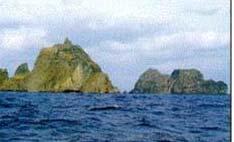
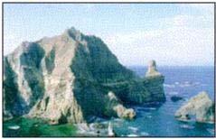
8 LIANCOURT ROCKS LIANCOURT ROCKS (TAKESHIMA OR TOK DO)


9 SPRATLY ISLANDS CLAIMS/ OCCUPATION Mischief Reef

10 Spratly Island (occupied by Vietnam)

11 Thitu Island (occupied by The Philippines)


12 Machias Seal Island (United States)
13 Stumbling Blocks to Maritime Boundary Delimitation Sovereignty Disputes 44 Treaty interpretation Perceived geographic imbalance

14 United States- Canada Maritime Boundaries Beaufort Sea Dixon Entrance Juan de Fuca Gulf of Maine
15 Beaufort Sea U.S. - Canada
 A-B LINE EQUIDISTANT LINE")
16 DIXON ENTRANCE Alaska (U.S.) A-B LINE EQUIDISTANT LINE Can.
17
18 Stumbling Blocks to Maritime Boundary Delimitation Sovereignty Disputes Treaty interpretation 44 Perceived geographic imbalance
19 United States (American Samoa)- Niue Equidistant line
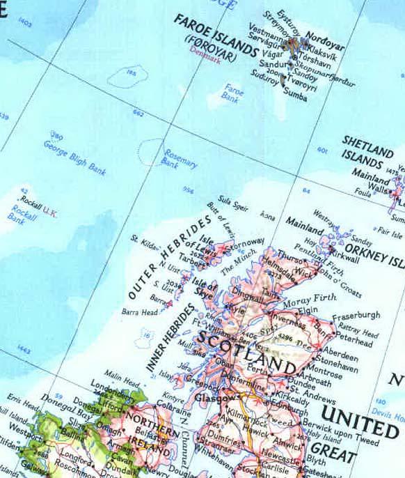
20 Rockall Rockall
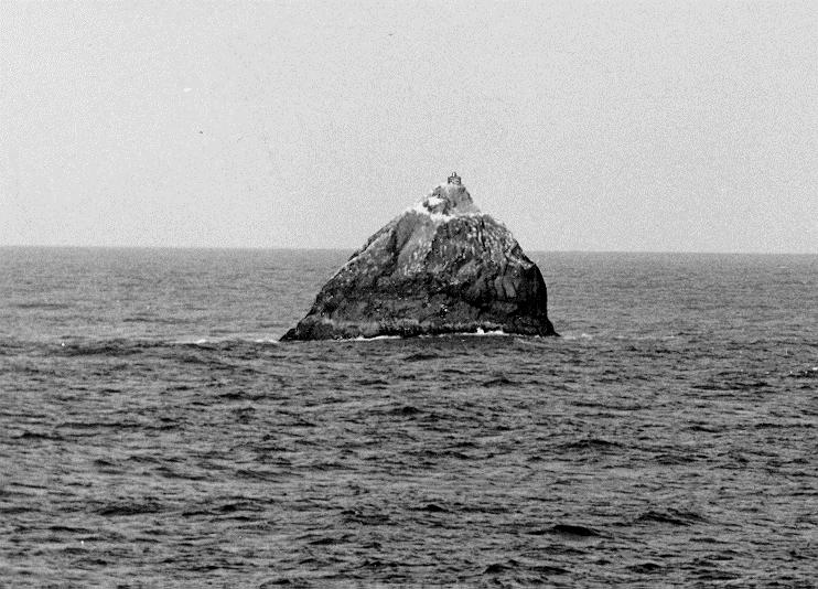
21 Rockall
22 Boundary delimitation process 4 Stages Make boundary claim Active negotiations Interim arrangements Implementation
23 United States Extended Maritime Jurisdiction
24 Practical Steps in the Negotiating Process 1. The Delimitation Process 2. Building and Preparing a Team 3. The Negotiations 4. Domestic Political Considerations 5. Elements of a Good Boundary Agreement
25 Developing the Negotiating Position(s) Establish overall strategy (National Ocean Policy) Boundary positions should be consistent Should consider boundaries within overall foreign policy context Should reflect identified national interests
26 Who identifies national interests? Cabinet level Inter-agency group, headed by high level officials Experts at working level Agencies: Foreign Ministry, Defense, Transportation, Fisheries, Oil & Gas, Coast Guard, Customs, Enforcement
27 Identifying national interests 1. International relations with neighbors 2. Economic/commercial interests Fisheries Oil & Gas Hard minerals/other Transportation: surface, pipelines Tourism 3. Military & strategic
28 The Negotiating Team Head of Negotiating Team: 1. Picked by President/ PM/ Secretary of State 2. Legal Adviser of Foreign Ministry 3. Head of Country Bureau 4. Minister of one of the Agencies (Fish, Oil and Gas, MFA)
29 The Negotiating Team Members of the Team Lawyers Technical experts Substantive experts (fisheries, oil & gas, enforcement)
30 Bases for Negotiations International Law Law of the Sea Convention State Practice International Judgments (ICJ- Arbitrations) Bilateral History
31 Practical Steps in the Negotiating Process 1. The Delimitation Process 2. Building and Preparing a Team 3. The Negotiations 4. Domestic Political Considerations 5. Elements of a Good Boundary Agreement
32 Develop Working Relations With Neighbor Put actual negotiations on hold Work on joint fishery plan Jointly survey key coastal areas Conduct oil & gas study

33 United States - Mexico Western Gap Coastal GPS Survey Project SUMMER 1998


")
34 Joint Survey Work Isles Derniere (Raccoon Island) Louisiana W E


35 Raccoon Island Taking positions with the PLGRs
36 Isle Dernieres (Raccoon Island) Comparing Surveyed Points to Chart


37 Arrecife Alacran The search for Mexican basepoints Submerged features Rock (above water)
38 No boundary solution in sight: What then? Interim measures Other solutions: Joint Zones Partial delimitation
39 Interim (Provisional) Measures Law of the Sea Conventionarticles 74 and 83 make every effort to enter into provisional arrangements of a practical nature and, during this transitional period, not to jeopardize or hamper the reaching of the final agreement.
40 Beaufort Sea: U.S. Oil Lease Sales Escrow Accounts in Disputed Area
41 Fisheries Enforcement: Dixon Entrance Interim Measures >Enforce against nationals > No third-party fishing
42 Other Possibilities Joint zones Partial delimitation ( gap ) Limit jurisdiction for islands Put sovereignty disputes on hold
43 Practical Steps in the Negotiating Process 1. The Delimitation Process 2. Building and Preparing a Team 3. The Negotiations 4. Domestic Political Considerations 5. Elements of a Good Boundary Agreement
44 Consultations?? Questions to ask when developing the National boundary positions: Does the Constitution require that the treaty be ratified? If yes, by whom: a Senate or other ruling body? If yes, then politically, it would be wise to keep this body informed of negotiating process, and to seek advice. Advice from affected industries should be obtained.
45 Practical Steps in the Negotiating Process 1. The Delimitation Process 2. Building and Preparing a Team 3. The Negotiations 4. Domestic Political Considerations 5. Elements of a Good Boundary Agreement
46 Elements of a Good Boundary May be years later before a valid assessment can be made Broad assessment: National perspective: reflects the national interests that have been identified; can be ratified Bilateral perspective: States remain amicable and on friendly terms as a result of negotiations
47 Elements of a Good Boundary Treaty Language All users can apply treaty provisions in a consistent and identical manner Legal terminology is comprehensive and understandable Technical information is sufficient and applicable
48 The American Society of International Law International Maritime Boundaries Martinus Nijhoff Publishers Vols. I-III Edited by Jonathan Charney and Lewis Alexander Vol. IV Edited by Jonathan Charney and Robert Smith Vol. V Smith-Colson : 2004 (?)
Maritime Boundary Issues Singapore Workshop: Session 4
 Maritime Boundary Issues Singapore Workshop: Session 4 How States deal with factors that can affect boundary negotiations Dr. Robert W. Smith Independent Geographic Consultant U.S. Department of State
Sam Bateman and. State Practice Regarding Straight Baselines In East Asia Legal, Technical and Political Issues in a
 State Practice Regarding Straight Baselines In East Asia Legal, Technical and Political Issues in a Changing Environment Sam Bateman and Clive Schofield The Australian National Centre for Ocean Resources
Maritime delimitation and environmental protection of fragile seas
 Gemma Andreone Istituto di Studi Giuridici Internazionali - Consiglio Nazionale delle Ricerche Marsafenet Cost Action Chair - www.marsafenet.org Maritime delimitation and environmental protection of fragile
Some Thoughts on Maritime Delimitation among the Northeast Asian States
 Some Thoughts on Maritime Delimitation among the Northeast Asian States Seokwoo LEE Assistant Professor College of Law INHA University Korea leeseokwoo@inha.ac.kr 1 I. Common geographical features II.
Pacific Islands Regional Maritime Boundaries Project the latest Update. Malakai Vakautawale (Mr) Maritime Boundaries Adviser
 Maritime Boundaries Adviser") Pacific Islands Regional Maritime Boundaries Project the latest Update Malakai Vakautawale (Mr) Maritime Boundaries Adviser Consortium Partners 2 What we do? Provide technical advice and support on MB
Pacific Islands Regional Maritime Boundaries Project the latest Update Malakai Vakautawale (Mr) Maritime Boundaries Adviser Consortium Partners 2 What we do? Provide technical advice and support on MB
Sharing the Resources of the South China Sea
 Sharing the Resources of the South China Sea MARK J. VALENCIA Senior Fellow, East-West Center, Honolulu, Hawaii, U.SA. JON M. VAN DYKE Professor oflaw, Wm. S. Richardson School oflaw, University of Hawaii,
Iceland and the Arctic: The Politics of Territoriality. Valur Ingimundaron Professor of Contemporary History, University of Iceland
 Iceland and the Arctic: The Politics of Territoriality Valur Ingimundaron Professor of Contemporary History, University of Iceland Drivers of Icelandic Arctic Policies Geostrategic Position Economic Interests
Regional Aspects of Maritime Boundary Delimitation in the Gulf of Guinea: current situation, challenges and possible solutions
 Regional Aspects of Maritime Boundary Delimitation in the Gulf of Guinea: current situation, challenges and possible solutions BY JUSTIN TANGA BIANG UNNIPPON ALUMNAE 20092010 INTRODUCTION (1) For the purpose
DELIMITATION OF THE MOZAMBIQUE MARITIME BOUNDARIES WITH NEIGHBORING STATES (INCLUDING THE EXTENDED CONTINENTAL SHELF) AND MANAGEMENT OF OCEAN ISSUES
 AND MANAGEMENT OF OCEAN ISSUES") DELIMITATION OF THE MOZAMBIQUE MARITIME BOUNDARIES WITH NEIGHBORING STATES (INCLUDING THE EXTENDED CONTINENTAL SHELF) AND MANAGEMENT OF OCEAN ISSUES Elisio B. Jamine United Nations The Nippon Fellowship
DELIMITATION OF THE MOZAMBIQUE MARITIME BOUNDARIES WITH NEIGHBORING STATES (INCLUDING THE EXTENDED CONTINENTAL SHELF) AND MANAGEMENT OF OCEAN ISSUES Elisio B. Jamine United Nations The Nippon Fellowship
GeomaticsWorld. Issue No 3 : Volume 21. Helping to unravel Easter Island s mysterious statues. DGI 2013: maritime security highlighted
 GeomaticsWorld MARCH APRIL 2013 Issue No 3 : Volume 21 BIM: repeat the message even if you lose the will to live Helping to unravel Easter Island s mysterious statues DGI 2013: maritime security highlighted
Pacific Islands Regional Maritime Boundaries Project
 Pacific Islands Regional Maritime Boundaries Project 31 st Star Conference, Nadi, FIJI 6-8 June 2016 Jens Kruger Head of Ocean & Coastal Geoscience Sector Andrick Lal Project Officer (Surveying) Emily
EXECUTIVE SUMMARY A PARTIAL SUBMISSION OF DATA AND INFORMATION ON THE OUTER LIMITS OF THE CONTINENTAL SHELF OF THE KINGDOM OF TONGA PURSUANT TO
 EXECUTIVE SUMMARY A PARTIAL SUBMISSION OF DATA AND INFORMATION ON THE OUTER LIMITS OF THE CONTINENTAL SHELF OF THE KINGDOM OF TONGA PURSUANT TO PART VI OF AND ANNEX II TO THE UNITED NATIONS CONVENTION
The Relevance of Hydrography to UNCLOS; an Indonesian Perspective By: Prof. Dr. Hasjim Djalal, MA*
 The Relevance of Hydrography to UNCLOS; an Indonesian Perspective By: Prof. Dr. Hasjim Djalal, MA* As I understand it, the theme of this 6 th ABLOS Conference 2010 is Contentious Issues in UNCLOS- surely
Ocean Governance and the Japanese Basic Act on Ocean Policy
 Ocean Governance and the Japanese Basic Act on Ocean Policy Hiroshi Terashima Executive Director Ocean Policy Research Foundation 14 April 2009 The United Nations Nippon Foundation Fellowship Programme
World Oceans Day 2010 Our oceans: opportunities and challenges
 World Oceans Day 2010 Our oceans: opportunities and challenges Roundtable discussion on the United Nations Convention on the Law of the Sea fifteen years after its entry into force HOW EFFECTIVELY IS UNCLOS
CONTENTS. PREFACE AND ACKNOWLEDGEMENTS...xi ABBREVIATIONS... xiii FIGURES...xvii INTRODUCTION...1
 CONTENTS PREFACE AND ACKNOWLEDGEMENTS...xi ABBREVIATIONS... xiii FIGURES...xvii INTRODUCTION...1 CHAPTER 1 MAPS OF THE MARITIME WORLD AND LEGAL DEFINITIONS...21 1.1 Maps of the Maritime World...21 1.1.1
Captain J. Ashley Roach, JAGC, USN (retired) Office of the Legal Adviser U.S. Department of State (retired) Visiting Senior Principal Research Fellow
 Office of the Legal Adviser U.S. Department of State (retired) Visiting Senior Principal Research Fellow") Captain J. Ashley Roach, JAGC, USN (retired) Office of the Legal Adviser U.S. Department of State (retired) Visiting Senior Principal Research Fellow Centre for International Law NUS Singapore SCS Award
Captain J. Ashley Roach, JAGC, USN (retired) Office of the Legal Adviser U.S. Department of State (retired) Visiting Senior Principal Research Fellow Centre for International Law NUS Singapore SCS Award
EXECUTIVE SUMMARY A SUBMISSION OF DATA AND INFORMATION ON THE OUTER LIMITS OF THE CONTINENTAL SHELF OF THE REPUBLIC OF NIGERIA PURSUANT TO
 EXECUTIVE SUMMARY A SUBMISSION OF DATA AND INFORMATION ON THE OUTER LIMITS OF THE CONTINENTAL SHELF OF THE REPUBLIC OF NIGERIA PURSUANT TO PART VI OF AND ANNEX II TO THE UNITED NATIONS CONVENTION ON THE
Geographical analysis in maritime boundary delimitation
 Geographical analysis in maritime boundary delimitation Martin Pratt International Boundaries Research Unit Durham University, UK 1 Abstract Nearly one third of the earth s ocean area is now under coastal
CX Debate Topic Analysis
 CX Debate Topic Analysis Larry McCarty lmac916@gmail.com or larry.mc@excite.com Resolved: The United States federal government should substantially increase its nonmilitary exploration and/or development
REPUBLIC OF THE MARSHALL ISLANDS MARITIME ZONES DECLARATION ACT 2016.
 Republic of the Marshall Islands Maritime Zones Declaration Act 2016. 33MIRCCh.1Index TITLE 33 - MARINE ZONES AND PROTECTION OF MAMMALS CHAPTER 1 - MARITIME ZONE DECLARATION s Republic of the Marshall
A Parliamentary Resolution on Iceland's Arctic Policy
 A Parliamentary Resolution on Iceland's Arctic Policy (Approved by Althingi at the 139th legislative session March 28 2011) Althingi resolves to entrust the Government, after consultations with Althingi,
Chapter 12: Pacific Realm and Polar Futures
 Geography: Realms, Regions and Concepts 15 th Edition By de Blij and Muller Chapter 12: Pacific Realm and Polar Futures Defining the Realm Sea Hemisphere: seas covering nearly an entire hemisphere Fragmented,
Pacific Islands Regional Maritime Boundaries Project
 Pacific Islands Regional Maritime Boundaries Project Presented By Filimoni Yaya (Andrick Lal, Sachindra Singh, Emily Artack) Geoscience Division Pacific Community (SPC Geoscience Division, GSD STAR Sessions,
Polar complications in the law of the sea: A case study of the regime for research and survey activities in the Arctic Ocean
 2010 ABLOS Conference: Contentious Issues in UNCLOS Surely Not? International Hydrographic Bureau, 25-27 October 2010 Polar complications in the law of the sea: A case study of the regime for research
Slide 1 Geography: Realms, Regions, and Concepts 15 th Edition. Slide 2. Slide 3 Defining the Realm. Chapter 12: Pacific Realm and Polar Futures
 Slide 1 Geography: Realms, Regions, and Concepts 15 th Edition Chapter 12: Pacific Realm and Polar Futures Slide 2 Slide 3 Defining the Realm Sea Hemisphere: seas cover nearly an entire hemisphere: Fragmented,
CONFERENCE OF PARLIAMENTARIANS OF THE ARCTIC REGION. UN LOS Convention and the extended continental shelf in the Arctic
 CONFERENCE OF PARLIAMENTARIANS OF THE ARCTIC REGION UN LOS Convention and the extended continental shelf in the Arctic Presentation given by Dr. Kamrul Hossain Finnish Parliament 18 November 2009 Contents
E/CONF.105/115/CRP.115***
 E/CONF.105/115/CRP.115*** 30 June 2017 Original: English 11 th United Nations Conference on the Standardization of Geographical Names New York, 8-17 August 2017 Item 9a) of the provisional agenda* National
Underwater Parks: Three Case Studies, and a Primer on Marine Boundary Issues. Robert E. Johnson Leland F. Thormahlen
 Robert E. Johnson Leland F. Thormahlen Underwater Parks: Three Case Studies, and a Primer on Marine Boundary Issues Unlike boundaries on land, most marine boundaries are not marked with monuments or fences.
OUTER CONTINENTAL SHELF CLAIMS IN THE ARCTIC. Presentation given by Dr. Kamrul Hossain ASA University Bangladesh 15 March 2010
 OUTER CONTINENTAL SHELF CLAIMS IN THE ARCTIC Presentation given by Dr. Kamrul Hossain ASA University Bangladesh 15 March 2010 Contents Historical background of the continental shelf Concept of continental
Indonesia s Internal Maritime Boundaries
 University of Wollongong-Lecture in Boundaries, November 2005 Indonesia s Internal Maritime Boundaries 1 Lecture Outline Indonesia's internal maritime boundaries Law no. 22/1999 --> Law no. 32/2004 Technical
MODELS AND TOOLS FOR GOVERNANCE OF
 Working Papers Collection No. 1/2015 MODELS AND TOOLS FOR GOVERNANCE OF THE ADRIATIC AND IONIAN SEAS www.unimc.it/maremap NATIONAL POLITICS AND EU POLITICS: THE MARITIME SPATIAL PLANNING AND INTEGRATED
Niue Maritime Boundaries Delimitation Project. Christchurch FIGMM
 Niue Maritime Boundaries Delimitation Project Christchurch FIGMM 30 th April 6 th May 2016 Hubert Mana Kalauni Secretary for Justice Department of Justice, Lands and Survey Ministry of Social Services
Tore Henriksen a & Geir Ulfstein b a Faculty of Law, University of Tromsø, Tromsø, Norway. Available online: 18 Feb 2011
 This article was downloaded by: [Bibliotheek van het Vredespaleis] On: 03 May 2012, At: 03:44 Publisher: Taylor & Francis Informa Ltd Registered in England and Wales Registered Number: 1072954 Registered
Indian Council of World Affairs Sapru House, Barakhambha Road New Delhi. Policy Brief. The Arctic Council: Is There a Case for India
 Indian Council of World Affairs Sapru House, Barakhambha Road New Delhi Policy Brief The Arctic Council: Is There a Case for India Dr Vijay Sakhuja* It is an acknowledged fact that the melting of the Arctic
State Practice on the Establishment of Multiple Maritime Boundaries: Assessing the Challenges of Separating Seabed and Water Column Boundaries
 State Practice on the Establishment of Multiple Maritime Boundaries: Assessing the Challenges of Separating Seabed and Water Column Boundaries Professor Clive Schofield The Australian National Centre for
Briefing document of the status of maritime boundaries in Pacific island countries
 Secretariat of the Pacific Community Seventh Heads of Fisheries Meeting (28 Feb. 4 March 2011, Noumea, New Caledonia) Working Paper 5 Original: English Briefing document of the status of maritime boundaries
How to Deal with Maritime Boundary Uncertainty in Oil and Gas Exploration and Production Areas*
 The University of Texas School of Law Presented: International Upstream Energy Transactions January 17-18, 2013 Houston, TX How to Deal with Maritime Boundary Uncertainty in Oil and Gas Exploration and
Geopolitics of the South China Sea
 Geopolitics of the South China Sea Ben Cahill Manager, Research and Advisory Group February 21, 2012 Powerful Thinking for the global energy industry Is the South China Sea The Future of Conflict? Just
The Place of Joint Development in the Sustainable Arctic Governance
 The Place of Joint Development in the Sustainable Arctic Governance ShipArc2015: Joint WMU - IMO - Arctic Council International Conference on Safe and Sustainable Shipping in a Changing Arctic Environment
Panel III: Islands and Rocks:
 KMI, COLP, and NILOS Conference on Globalization and the Law of the Sea Panel III: Islands and Rocks: How Much Can a Rock Get? A Reflection from the Okinotorishima Rocks 1-3 December 2010 Marriot Metro
Geopolitical Considerations of the Senkaku Islands
 Geopolitical Considerations of the Senkaku Islands Akiyama Masahiro 1. Introduction 2. Geographic Conditions 3. Legal Effects of Islands as Territory 4. Maritime Interests and Security Matters 5. Geopolitical
MARINE SPATIAL PLANNING & MARINE CADASTRE: CHALLENGES AND ISSUES
 MARINE SPATIAL PLANNING & MARINE CADASTRE: CHALLENGES AND ISSUES Roger Longhorn Secretary General, GSDI Association rlonghorn@gsdi.org Member, IHO Marine SDI Working Group ral@alum.mit.edu Member, UNESCO
Stewardship of the Central Arctic Ocean: The Arctic 5 versus the international community
 Stewardship of the Central Arctic Ocean: The Arctic 5 versus the international community The Central Arctic Ocean Ilulissat Declaration 2008 By virtue of their sovereignty, sovereign rights and jurisdiction
Chapter 8. Political Geography
 Chapter 8 Political Geography Nations of the World Today human geographers emphasize a thematic approach, concerned with the location of activities in the world, the reasons for particular spatial distributions,
This Book Belonged to
 THE AMERICAN UNIVERSITY Washington College of Law Library This Book Belonged to The Private Collection of Judge Richard R, Baxter I THE AMERICAN UNIVERSITY Washington College of Law Law Library W-, D.C.
MARITIME BRIEFING. International Boundaries Research Unit. Volume 3 Number 1. Undelimited Maritime Boundaries of the Asian Rim in the Pacific Ocean
 International Boundaries Research Unit MARITIME BRIEFING Volume 3 Number 1 Undelimited Maritime Boundaries of the Asian Rim in the Pacific Ocean Victor Prescott and Clive Schofield Maritime Briefing Volume
Policy framework The Netherlands and the Polar Regions, Summary and priorities
 Policy framework The Netherlands and the Polar Regions, 2011-2015 Summary and priorities The policy outlined in this Policy Framework for the Polar Regions (2011-2015) is part of the government s orientation
Boundaries and Borders
 Political Geography Origins: Antecedent Boundaries and Borders Existed in prehistoric times Usually align with physical boundaries Pyrenees between France/Spain Cultural linguistic borders between Germanic
Draft Presentation Carleton Conference on the Arctic Is There a Need for New Legal Regime in the Arctic?
 Draft Presentation Carleton Conference on the Arctic Is There a Need for New Legal Regime in the Arctic? Donald McRae, University of Ottawa The climatic changes affecting the Arctic have lead to visions
The Changing Arctic: Strategic Opportunities and Challenges
 The Changing Arctic: Strategic Opportunities and Challenges Sherri Goodman Senior Vice President & General Counsel Executive Director, CNA Military Advisory Board 1 New Access to Resources Oil and Gas
Drawing the Borderline- The Equidistant Principle or Equitable Solutions in the Delimitation of Maritime Boundaries
 Drawing the Borderline- The Equidistant Principle or Equitable Solutions in the Delimitation of Maritime Boundaries Abstract The high seas are posing new challenges for mankind. This is hinged on the availability
International Law in the South China Sea
 International Law in the South China Sea The Philippines-China Dispute Luz Danielle O. Bolong Harvard Law School April 2, 2014 Award on Jurisdiction, Figure 1 (citing RP Memorial, Figure 2.1; amti.csis.org
Law of the Sea Symposium, February, 2016, TOKYO International Law for the Resources of the Sea
 Law of the Sea Symposium, 16-17 February, 2016, TOKYO International Law for the Resources of the Sea Segment 2 Governance of Resources of the Continental Shelf (including extended continental shelf) Introduction
Turkey National Report
 UNITED NATIONS Working Paper GROUP OF EXPERTS ON No. 26 GEOGRAPHICAL NAMES Twenty-third Session Vienna, 28 March 4 April 2006 Item 5 of the Provisional Agenda: Reports of the division Turkey National Report
ITLOS s approach to the delimitation of the continental shelf beyond 200 M in Bangladesh/Myanmar: Theoretical and practical difficulties
 ITLOS s approach to the delimitation of the continental shelf beyond 200 M in Bangladesh/Myanmar: Theoretical and practical difficulties London International Boundary Conference 18-19 April 2013 Panel
ROCKS V. ISLANDS: NATURAL TENSIONS OVER ARTIFICIAL FEATURES IN THE SOUTH CHINA SEA. F. Shannon Sweeney*
 ROCKS V. ISLANDS: NATURAL TENSIONS OVER ARTIFICIAL FEATURES IN THE SOUTH CHINA SEA F. Shannon Sweeney* ABSTRACT This Note examines the international arbitration proceeding commenced on January 22, 2013
The Contribution of Hydrographic Charting to the Resolution and Portrayal of Offshore Property and Jurisdictional Boundaries.
 The Contribution of Hydrographic Charting to the Resolution and Portrayal of Offshore Property and Jurisdictional Boundaries. Susan Nichols, Geodesy and Geomatics Engineering, University of New Brunswick
No. 2009/9 3 February Maritime Delimitation in the Black Sea (Romania v. Ukraine)
") INTERNATIONAL COURT OF JUSTICE Peace Palace, Carnegieplein 2, 2517 KJ The Hague, Netherlands Tel.: +31 (0)70 302 2323 Fax: +31 (0)70 364 9928 Website: www.icj-cij.org Press Release Unofficial No. 2009/9
INTERNATIONAL COURT OF JUSTICE Peace Palace, Carnegieplein 2, 2517 KJ The Hague, Netherlands Tel.: +31 (0)70 302 2323 Fax: +31 (0)70 364 9928 Website: www.icj-cij.org Press Release Unofficial No. 2009/9
Dr. Biliana Cicin-Sain 8 April th Meeting of the UN Open-ended Informal Consultative Process on Oceans and the Law of the Sea
 Enabling Factors in Achieving Sustainable Development of Oceans: Experiences with National and Regional Ocean Policies and Implications for the Implementation of Goal 14 on Oceans and Seas Dr. Biliana
xxv PART I THE DIVIDED OCEANS: INTERNATIONAL LAW GOVERNING JURISDICTIONAL ZONES 1
 Contents Preface page xv List of Figures xvii List of Tables xviii List of Abbreviations xix Table of Cases xxi Table of Treaties and Instruments xxv PART I THE DIVIDED OCEANS: INTERNATIONAL LAW GOVERNING
The Three Equidistance Lines in Maritime Delimitation: What and Why? By: Dany Channraksmeychhoukroth* (Aug 2015)
") The Three Equidistance Lines in Maritime Delimitation: What and Why? By: Dany Channraksmeychhoukroth* (Aug 2015) Equidistance is a common term in math defined as the equal distance from every point. Similarly,
The Three Equidistance Lines in Maritime Delimitation: What and Why? By: Dany Channraksmeychhoukroth* (Aug 2015) Equidistance is a common term in math defined as the equal distance from every point. Similarly,
COMPLICATIONS IN DELIMITING THE OUTER CONTINENTAL SHELF. Ron Macnab Geological Survey of Canada (Retired)
") COMPLICATIONS IN DELIMITING THE OUTER CONTINENTAL SHELF Ron Macnab Geological Survey of Canada (Retired) DISCLAIMER The contents of this presentation are the author s personal views only, and do not represent
COMPLICATIONS IN DELIMITING THE OUTER CONTINENTAL SHELF Ron Macnab Geological Survey of Canada (Retired) DISCLAIMER The contents of this presentation are the author s personal views only, and do not represent
Disputes Concerning the Delimitation of the Continental Shelf beyond 200 M
 Disputes Concerning the Delimitation of the Continental Shelf beyond 200 M Professor Clive Schofield Head of Research, WMU/Sasakawa Global Ocean Institute World Maritime University Sweden and Leonardo
Mindful of the interests which the Parties share as immediate neighbours, and in a spirit of cooperation, friendship and goodwill; and
 page 1 Delimitation Treaties Infobase accessed on 13/03/2002 Treaty between the Government of Australia and the Government of the Republic of Indonesia establishing an exclusive economic zone boundary
Delimitation of the continental shelf beyond 200 M in the light of recent case law
 Delimitation of the continental shelf beyond 200 M in the light of recent case law K.G. Jebsen Centre for the Law of the Sea Centre Days Workshop 23 September 2014 Session 2 Alex G. Oude Elferink K.G.
International Boundary Study
 International Boundary Study Series A Limits in the Seas No. 1 January 21, 1970 Indonesia Malaysia Continental Shelf Boundary (Country Codes: ID-MY) The Geographer Office of the Geographer Bureau of Intelligence
MARITIME PLANNING IN PORTUGAL
 MARITIME PLANNING IN PORTUGAL Marta Chantal Ribeiro 2 May 2007 In Portugal there is currently no strategic planning system in force for the maritime area as a whole The maritime area under Portuguese jurisdiction
ARTICLE I NATIONAL TERRITORY
 ARTICLE I NATIONAL TERRITORY The national territory comprises the Philippine archipelago, with all the islands and waters embraced therein, and all other territories over which the Philippines has sovereignty
Nation: geographic area that is dominated by a large population that shares a common history and culture, ie. Kurds and Palestinians.
 Nation: geographic area that is dominated by a large population that shares a common history and culture, ie. Kurds and Palestinians. State: sovereign (implies a state's lawful control over it's territory
National Security Presidential Directive and Homeland Security Presidential Directive
 For Immediate Release Office of the Press Secretary January 12, 2009 National Security Presidential Directive and Homeland Security Presidential Directive January 9, 2009 NATIONAL SECURITY PRESIDENTIAL
Outer Continental Shelf
 The Delimitation of the Outer Continental Shelf Presentation by Stephen Fietta Monaco, 17 October 2008 Latham & Watkins is the business name of Latham & Watkins (London) LLP, a registered limited liability
GIS, Charts and UNCLOS Can they live together?
 GIS, Charts and UNCLOS Can they live together? Bill Hirst 1 and David Robertson 2 Address 1 Geoscience Australia GPO Box 378 Canberra, ACT 2601 Phone: 02 6249 9741 Fax: 02 6249 9939 Email: Bill.Hirst@ga.gov.au
Norway s Integrated Ocean Management (IOM) Policies and Plans - A Brief Presentation
 Policies and Plans - A Brief Presentation") OGS/- 20.08.2014. Paper based on an up-dated version of the author's presentation at the seminar "Økosystembasert tilnærming i Norge" ("Ecosystems-based Approach in Norway"), organized by the Tromsø University,
OGS/- 20.08.2014. Paper based on an up-dated version of the author's presentation at the seminar "Økosystembasert tilnærming i Norge" ("Ecosystems-based Approach in Norway"), organized by the Tromsø University,
NAVIGATION AND VESSEL INSPECTION CIRCULAR NO
 COMDTPUB P16700.4 NVIC 13-92 15 Dec 1992 NAVIGATION AND VESSEL INSPECTION CIRCULAR NO. 13-92 Electronic Version for Distribution Via the World Wide Web Subj: Captain of the Port Zone Boundaries 1. PURPOSE.
Implementing Rio+20: Integrated Planning For Sustainable Coastal Area Management In the Caribbean Region
 Expert Group Meeting Implementing Rio+20: Integrated Planning For Sustainable Coastal Area Management In the Caribbean Region Address by Ronny Jumeau Seychelles Ambassador for Climate change And SIDS Issues
Marine Spatial Planning in Hellas; Recent Facts and Perspectives
 XXV FIG CONGRESS Engaging the Challenges, Enhancing the Relevance Kuala Lumpur, Malaysia 16 21 June 2014 Marine Spatial Planning in Hellas; Recent Facts and Perspectives Mrs. Chaiditsa BOLANOU Surveying
BASICS OF THE STATE POLICY OF THE RUSSIAN FEDERATION IN THE ARCTIC FOR THE PERIOD TILL 2020 AND FOR A FURTHER PERSPECTIVE. I. General provisions
 Adopted by the President of the Russian Federation D. Medvedev September 18, 2008 Translated from Russian Promulgated: March 30, 2009, publication of the official governmental newspaper Rossiyskaya Gazeta
SIXTH REGULAR SESSION, 2017 C.B. NO A BILL FOR AN ACT
 NINETEENTH CONGRESS OF THE FEDERATED STATES OF MICRONESIA SIXTH REGULAR SESSION, 0 C.B. NO. - A BILL FOR AN ACT To amend title of the code of the Federated States of Micronesia by amending existing sections
Offshore Energy and Maritime Spatial Planning in the German EEZ
 Offshore Energy and Maritime Spatial Planning in the German EEZ Bettina Käppeler, BSH Federal Maritime and Hydrographic Agency On Duty for Shipping and Seas German Exclusive Economic Zone EEZ not part
The application of international law principle in practice of the delimitation on continental shelf
 World Maritime University The Maritime Commons: Digital Repository of the World Maritime University World Maritime University Dissertations Dissertations 2013 The application of international law principle
Coastal Erosion and Its Impact on Some Aspects of Maritime Boundaries
 March 2016 Abstract While coastal erosion is fundamentally an environmental issue, coastal erosion can impact basic issues in maritime boundaries like baselines and the question of maritime zones. Such
Limits in the Seas. No. 96 June 6, Greece Italy. Continental Shelf Boundary. (Country Codes: GR-IT)
") Limits in the Seas No. 96 June 6, 1982 Greece Italy Continental Shelf Boundary (Country Codes: GR-IT) The Geographer Office of the Geographer Bureau of Intelligence and Research INTERNATIONAL BOUNDARY
Limits in the Seas No. 96 June 6, 1982 Greece Italy Continental Shelf Boundary (Country Codes: GR-IT) The Geographer Office of the Geographer Bureau of Intelligence and Research INTERNATIONAL BOUNDARY
Exclusive Economic Zone Claims By R. Smith
 Exclusive Economic Zone Claims By R. Smith If you are looking for the book by R. Smith Exclusive Economic Zone Claims in pdf format, then you have come on to the loyal site. We furnish full option of this
The Agreement Concerning the Boundary Line Dividing Parts of the Continental Shelf Between Iran and the United Arab Emirates states that:
 2 The Imperial Government of Iran and the Government of the State of the United Arab Emirates (Dubai) signed an agreement on August 31, 1974, regarding the delimitation of their continental shelf boundary.
Issue of the Name of the Sea of Japan. Overview of study of maps possessed by the Bibliotheque Nationale de France
 Issue of the Name of the Sea of Japan Overview of study of maps possessed by the Bibliotheque Nationale de France (March 2004) From October 2003 to January 2004, the Ministry of Foreign Affairs of Japan
Identification of Islands and Standardization of Their Names
 Identification of Islands and Standardization of Their Names Submitted by INDONESIA UNITED NATIONS GROUP OF EXPERTS ON GEOGRAPHICAL NAMES Eleventh United Nations Conference on the Standardization of Geographical
Maritime Boundary Delimitation: Recent ICJ Jurisprudence Nicaragua v Colombia; Peru v Chile
 Maritime Boundary Delimitation: Recent ICJ Jurisprudence Nicaragua v Colombia; Peru v Chile May 28, 2014 Prof. Seokwoo LEE Inha University Law School leeseokwoo@inha.ac.kr 1 Recent Developments The Black
What's at stake in the South China Sea? Geographical and geopolitical considerations
 University of Wollongong Research Online Faculty of Law, Humanities and the Arts - Papers Faculty of Law, Humanities and the Arts 2013 What's at stake in the South China Sea? Geographical and geopolitical
file:///c:/documents and Settings/kapilan/My Documents/WEB Domest...
 1 of 5 3/17/2011 1:15 PM Print Close Maritime Zones Law A LAW TO PROVIDE FOR THE DECLARATION OF THE TERRITORIAL SEA AND OTHER MARITIME ZONES OF SRI LANKA, AND ALL OTHER MATTERS CONNECTED THEREWITH OR INCIDENTAL
Council conclusions on Arctic issues. 2985th FOREIGN AFFAIRS Council meeting Brussels, 8 December 2009
 COU CIL OF THE EUROPEA U IO EN Council conclusions on Arctic issues 2985th FOREIGN AFFAIRS Council meeting Brussels, 8 December 2009 The Council adopted the following conclusions: The Council recalls its
1982 United Nations Convention on the Law of the Sea
 1982 United Nations Convention on the Law of the Sea Article 16, 47, 75, 76 and 84 Article 16, 47, 75, 76 and 84 require Coastal States to deposit geographic information pertaining to their maritime limits
A National Ocean Policy for Malaysia: Rationale and Proposed Components. Mohd Nizam Basiron and Cheryl Rita Kaur Maritime Institute of Malaysia
 A National Ocean Policy for Malaysia: Rationale and Proposed Components Mohd Nizam Basiron and Cheryl Rita Kaur Maritime Institute of Malaysia Outline of Presentation Objectives of Presentation Introduction
MALDIVES. Regional Expert Workshop On Land Accounting For SDG Monitoring & Reporting (25-27 th Sept 2017) - Fathimath Shanna, Aishath Aniya -
 - Fathimath Shanna, Aishath Aniya -") MALDIVES Regional Expert Workshop On Land Accounting For SDG Monitoring & Reporting (25-27 th Sept 2017) - Fathimath Shanna, Aishath Aniya - ABOUT MALDIVES Approximately 860 km long and 120 km wide Consists
MALDIVES Regional Expert Workshop On Land Accounting For SDG Monitoring & Reporting (25-27 th Sept 2017) - Fathimath Shanna, Aishath Aniya - ABOUT MALDIVES Approximately 860 km long and 120 km wide Consists
MARITIME ZONES FROM ISLANDS AND ROCKS. Paper by Professor Clive R. Symmons for the CIL Roundtable Singapore June 2013
 MARITIME ZONES FROM ISLANDS AND ROCKS Paper by Professor Clive R. Symmons for the CIL Roundtable Singapore June 2013 Basic Definition and Zone-Creating Capacity of an Island in IL . See Art 121(2) UNCLOS:
Towards the Conceptualisation of Maritime Delimitation
 Towards the Conceptualisation of Maritime Delimitation Legal and Technical Aspects of a Political Process NUNO MARQUES ANTUNES MARTINUS NIJHOFF PUBLISHERS Ll-LIDEN BOSTON CONTENTS General Introduction
Introduction. Security Council. Militarization of the Arctic. Student Officer: Chloe Aung
 Forum: Issue: Security Council Militarization of the Arctic Student Officer: Chloe Aung Position: Chair Introduction The Arctic Region consists of the Arctic Region, with parts of Canada, Russian Federation,
Bathymetry. EMODnet Stakeholder Conference & Sea-basin Workshops February Bathymetry
 EMODnet Stakeholder Conference & Sea-basin Workshops 14-15 February 2017 Arctic checkpoint Belinda Kater On behalf of all Checkpoints http://www.emodnet.eu 1 ? is the study of the "beds" or "floors" of
Country Fiche Latvia Updated October 2016
 Country Fiche Latvia Updated October 2016 1. General information Marine area under Latvian jurisdiction includes inland sea waters, Territorial sea (12 nautical miles from the baseline) and exclusive economic
CANADIAN HYDROGRAPHIC SERVICE & OCEANOGRAPHIC SERVICES
 CANADIAN HYDROGRAPHIC SERVICE & OCEANOGRAPHIC SERVICES Presentation to Warming of the North Conference Ottawa, March 2 nd, 2015 Denis Hains, Director General & Hydrographer General of Canada TIP OF THE