Some Very Helpful Boundary and Border Definitions
|
|
|
- Irma Hopkins
- 6 years ago
- Views:
Transcription
1 Some Very Helpful Boundary and Border Definitions Key Terms and Definitions: Boundary - something that indicates bounds or limits. Boundary Delimitation - political boundaries on Earth's surface are determined by the use of man-made structures such as fences and walls, i.e., United States/Mexico. Boundary Demarcation - there are no physical signs on Earth's surface to show that a boundary exists, i.e., Saudi Arabia/Omen. Boundary Dispute - when two or more states disagree about the demarcation of a political boundary. Compact State - the distance from the geographic center of the area to any point on the boundary does not vary greatly, i.e., Hungary. Elongated State - state that is geographically long and narrow, i.e., Chile. Enclave - portion of a state that is totally surrounded by another state, i.e., Armenian Nagorno-Karabagh Exclave -small portion of land that is separated from the main state, i.e., Kaliningrad/Russia. Fragmented State - state split into many pieces, i.e., Philippines and Indonesia. Landlocked State - state not having direct access to an ocean, i.e., Bolivia. Perforated State - state that totally surrounds another state, i.e., Lesotho/South Africa. Prorupt State - state having a portion of territory that is elongated, i.e., Thailand. Microstate - state that is extremely small, i.e., San Marine. Nation-State - political unit comprising a clearly delineated territory where the population shares a common history and culture, i.e., Japan. Subsoil - below the surface of Earth. Boundaries are vertical planes, not merely lines on a map. Frontier - zone where no state exercises political control, i.e., Antarctica and portions of Saudi Arabia. Physical Boundary - major physical features such as deserts, mountain ranges, and/or water bodies that serve as a means of separation, i.e., Great Lakes, Pureness Mountains, and Sahara Desert. Geometric Boundary - straight lines that serve as political boundaries that are unrelated to physical and /or cultural differences, i.e., United States/Canadian border. Cultural Political Boundary - political boundary that separates different cultures, i.e., former Yugoslavia. Religious Boundary - boundary that separates different religions, i.e., Northern Ireland/Ireland. Language Boundary - boundary that separates different language speakers, i.e., traditionally many countries in Europe such as England, France, Spain, and Portugal. Genetic Boundary - how boundaries evolve over time. Antecedent Boundary - boundary that was created before the present day cultural landscape developed, i.e., Malaysia/Indonesia on the island of Borneo. Subsequent Boundary - boundaries that are created as a result of long-term processes, i.e., Vietnam/China. Super Imposed Boundary - boundary that has been forced upon the inhabitants of an area to solve a problem and/or conflict, i.e., Indonesia/Papua New Guinea. Relict Boundary - boundary that ceases to exist, however the imprint of the boundary still remains on the cultural landscape, i.e., North/South Vietnam. Fortified Boundary - when a state constructs physical barriers along a boundary to either keep people in or out of its territory, i.e., Great Wall of China, Berlin Wall, earth berms along the Morocco/Spanish Sahara border. Nation - geographic area that is dominated by a large population that shares a common history and culture, i.e., Kurds and Palestinians. State - political entity that maintains status as an independent country. Boundaries result in a combination of natural physical features and cultural features. Natural physical features: Cultural features: - rivers - language - deserts - religion - mountains A frontier provides an area of separation, often kilometers in width, but a boundary brings two neighboring states into direct contact. Frontiers aren't used anymore, the only places that have them are Antarctica and the Arabian Peninsula.


2 Physical boundaries: - coincide with significant features of the Natural landscape. * Mountain boundaries: - difficult to cross - limited contact with other countries and nationalities. - permanent - sparsely inhabited Ex. Argentina and Chile, are separated at the crest of the Andes Mountains. *Desert boundaries: - Difficult to cross - Sparsely inhabited - Common in Africa and Asia Ex. Sahara separates Algeria, Libya, and Egypt from Mauritania, Mali, Niger, Chad, and South Sudan. *Water boundaries: - rivers, lakes, and oceans - visible on a map - relatively unchanging - common in East Africa - usually in middle of water - good protection Ex. The boundary between Congo Democratic Republic and Uganda runs through Lake Albert. Ex2. The boundary separating Kenya, Tanzania, and Uganda runs through Lake Victoria.


3 *Cultural boundaries: - The boundaries between some states coincide with differences in: - Ethnicity - Language - Religion - Geometry *Religious boundaries: - often coincide with boundaries between states. Rarely used to select boundary lines. Ex. South Asia. British partitioned India into two states on the basis of religion. The Muslims were moved to Pakistan and the Hindus became independent India. *Language boundaries - states that unify the speakers of a particular language: - France - England - Spain - Portugal - Germany - After WWI boundaries were redrawn due to language.. " *Geometric boundaries: Ex. The U.S and Canada. Border was established in 1846 by a treaty between the United States and Great Britain (who owned Canada.) U.S wanted the boundary to go from the 49 degrees north latitude to the 54 degrees 40 north latitude. "Fifty- four forty or fight *Cyprus's "Green Line" boundary: (Ethnicity) - Cyprus contains two nationalities: - Greek (78%) - Turkish (18%) Greek Cypriot military officers who favored unification of Cyprus with Greece seized control. - Turkey then invaded to protect the Turkish minority.


4 - Greek coup leaders were gone within a few months and the elected government came back. - Two nationalities became isolated, the Turks were in the Northeastern part and the Greeks were in the Southern part The Turks declared themselves the independent Turkish Republic of Northern Cyprus. Shapes of States *Compact shapes: -Ideal shape would be a circle. -Beneficial because it has better and easier communication. Ex. In Africa: -Burundi -Kenya -Rwanda -Uganda *Prorupted States: -Provides state with water resource. -Can also separate two states. Ex. Zaire (Congo) River. Elongated state: -isolated from the other end of the state. Ex. Chile


5 *Fragmented State: -Two different kinds: -Separated by water -Separated by land Ex. Indonesia * Perforated states Ex. South Africa completely surrounds Lesotho.

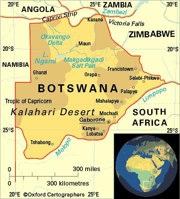
6 * Landlocked state: -Lesotho is also landlocked -A state completely surrounded by other states -No water access. Ex. Botswana, Lesotho, and Swaziland.
7
Nation: geographic area that is dominated by a large population that shares a common history and culture, ie. Kurds and Palestinians.
 Nation: geographic area that is dominated by a large population that shares a common history and culture, ie. Kurds and Palestinians. State: sovereign (implies a state's lawful control over it's territory
UNIT 4: POLITICAL ORGANIZATION OF SPACE
 UNIT 4: POLITICAL ORGANIZATION OF SPACE Advanced Placement Human Geography Session 1 ADVANCED PLACEMENT HUMAN GEOGRAPHY REVIEW SESSIONS: UNIT FOUR By Geri Flanary To accompany AP Human Geography: A Study
Geographical Characteristics of the State. The Cultural Mosaic Fellman, and Notes from D.J. Zeigler of Old Dominion
 Geographical Characteristics of the State The Cultural Mosaic Fellman, and Notes from D.J. Zeigler of Old Dominion Vocab Review State Sovereignty Nation Nation-state Binational or Multinational Stateless
Chapter 8. Political Geography
 Chapter 8 Political Geography Nations of the World Today human geographers emphasize a thematic approach, concerned with the location of activities in the world, the reasons for particular spatial distributions,
Chapter 8. Political Geography
 Chapter 8 Political Geography Nations of the World Today human geographers emphasize a thematic approach, concerned with the location of activities in the world, the reasons for particular spatial distributions,
Discovering the World of Geography
 Discovering the World of Geography Grades 7 8 By MYRL SHIREMAN COPYRIGHT 2003 Mark Twain Media, Inc. ISBN 10-digit: 1-58037-230-9 13-digit: 978-1-58037-230-5 Printing No. CD-1576 Mark Twain Media, Inc.,
Boundaries and Borders
 Political Geography Origins: Antecedent Boundaries and Borders Existed in prehistoric times Usually align with physical boundaries Pyrenees between France/Spain Cultural linguistic borders between Germanic
Supplementary Appendix for. Version: February 3, 2014
 Supplementary Appendix for When Do Governments Resort to Election Violence? Version: February 3, 2014 This appendix provides supplementary information not included in the published draft. Supplementary
National Council for Geographic Education Curriculum & Instruction Committee Geography Club Submitted by: Steve Pierce
 National Council for Geographic Education Curriculum & Instruction Committee Geography Club Submitted by: Steve Pierce stevepierce@charter.net Ninth Month Activities Geography for Life: National Geography
ia PU BLi s g C o M Pa K T Wa i n CD-1576
 M h M y CD-1576 o M Pa g C n ar ia PU BLi s in K T Wa i n ed National Geography Standards National Geography Standards Teachers leading discussions while completing units and activities is a prerequisite
a division of Teacher Created Materials
 Sample Pages from a division of Teacher Created Materials Thanks for checking us out. Please call us at 877-777-3450 with questions or feedback, or to order this product. You can also order this product
By Geri Flanary To accompany AP Human Geography: A Study Guide 3 rd edition By Ethel Wood
 Session 1 By Geri Flanary To accompany AP Human Geography: A Study Guide 3 rd edition By Ethel Wood WHAT IS DEMOGRAPHY? It is the scientific or statistical study of population. It comes from the Greek
September 14, 2013 Objective: How does geography impact history? What important features exist that have shaped societies?
 Lowenhaupt 1 September 14, 2013 Objective: How does geography impact history? What important features exist that have shaped societies? Warm-Up: In your binder, answer the following question: Imagine you
Key Issue #1. Where are states located?
 Political Geography Key Issue #1 Where are states located? Current World States State and Nation Terminology A nation is a group of people with a common ancestral heritage based on belief systems, customs,
Globes, Maps, and Atlases. Plus, A Whole Bunch of Other Way Cool Geographic Information!!!
 Globes, Maps, and Atlases Plus, A Whole Bunch of Other Way Cool Geographic Information!!! Globes Are the Most Accurate Portrayal of the Earth The earth is about 24,900 miles in circumference, and about
21st Century Global Learning
 21st Century Global Learning A focus for 7th grade is on the ever-increasing global interactions in society. This focus includes a study of various societies and regions from every continent. We have already
Country of Citizenship, College-Wide - All Students, Fall 2014
 Country of Citizenship, College-Wide - All Students, Fall 2014-49,552 (72%) students were U.S. Citizens in Fall 2014. - MDC's non-citizen students come from at least 167 countries and speak approximately
Central Valley School District Social Studies Curriculum Map Grade 7. August - September
 August - September Geographical/Historical Skills Identify and analyze timelines. Construct and use cause and effect charts. Differentiate between fact and opinion. Use of word webs, flip charts, outlines
Mexico, Central America and the Caribbean South America
 Objective: This assignment is a way to prepare you for many different aspects of AP Human Geography. You will be held accountable for this assignment; it will be the first grade of the quarter. Failure
About the Authors Geography and Tourism: The Attraction of Place p. 1 The Elements of Geography p. 2 Themes of Geography p. 4 Location: The Where of
 Preface p. ix About the Authors p. xi Geography and Tourism: The Attraction of Place p. 1 The Elements of Geography p. 2 Themes of Geography p. 4 Location: The Where of Geography p. 4 Place and Space:
The study of Geography and the use of geographic tools help us view the world in new ways.
 S How does Geography help us understand our world? What factors shape the Earth s different environments? 7.1.9 7.2.9 BIG IDEAS COMPETENCIES Text pages or The study of Geography and the use of geographic
Making a Mental Map of the Region
 Africa Preview Making a Mental Map of the Region Draw an outline map of Africa on the next page or on a separate sheet of paper. Add a compass rose to your map, showing where north, south, east, and west
Solow model: Convergence
 Solow model: Convergence Per capita income k(0)>k* Assume same s, δ, & n, but no technical progress y* k(0)=k* k(0) k Assume same s, δ, &
This image cannot currently be displayed. Course Catalog. History and Geography Glynlyon, Inc.
 This image cannot currently be displayed. Course Catalog History and Geography 2016 Glynlyon, Inc. History and Geography Table of Contents COURSE OVERVIEW... 1 UNIT 1: OUR EARTH... 1 UNIT 2: SEAPORT CITIES...
EXTRA CREDIT III IS DUE ON: Tuesday, May 15, 2018.
 Hunter College-CUNY GEOG 101 Intro to Geography Instructions for Extra Credit exercise for Exam 3 The extra credit exercises associated with each third of the course are worth a maximum of 9 points added
Nigerian Capital Importation QUARTER THREE 2016
 Nigerian Capital Importation QUARTER THREE 2016 _ November 2016 Capital Importation Data The data on Capital Importation used in this report was obtained from the Central Bank of Nigeria (CBN). The data
Map Skills Test. 1. What do we call a person who makes maps? a. mapographer b. cartographer c. geologist d. archaeologist
 Map Skills Test 1. What do we call a person who makes maps? a. mapographer b. cartographer c. geologist d. archaeologist 2. What is the name of the 0 latitude line? a. Equator b. Arctic Circle c. First
GINA Children. II Global Index for humanitarian Needs Assessment (GINA 2004) Sheet N V V VI VIII IX X XI XII XII HDR2003 HDR 2003 UNDP
 Sheet N V V VI VIII IX X XI XII XII HDR2003 HDR 2003 UNDP") Human UNICEF Index Index Natural 2003 GDP per Total as % of Total Rate HDI HPI Disasters Conflicts capita Population population 5 1 Congo, Democratic Republic of the 2,80000 3 3 1 3 3 3 3 3 3 3 2 Burundi
Human UNICEF Index Index Natural 2003 GDP per Total as % of Total Rate HDI HPI Disasters Conflicts capita Population population 5 1 Congo, Democratic Republic of the 2,80000 3 3 1 3 3 3 3 3 3 3 2 Burundi
International Student Enrollment Fall 2018 By CIP Code, Country of Citizenship, and Education Level Harpur College of Arts and Sciences
 International Student Enrollment Fall 2018 By CIP Code, Country of Citizenship, and Education Level Harpur College of Arts and Sciences CIP Code Description Citizenship Graduate Undergrad Total 00.0000
World Geography to ALL Students book (teacher book).
.") Sample Pages are from the What I Need to Know to Successfully Teach World Geography to ALL Students book (teacher book). This book contains the content in the student book, the reformatted Standards for
Sample Pages are from the What I Need to Know to Successfully Teach World Geography to ALL Students book (teacher book). This book contains the content in the student book, the reformatted Standards for
7th Grade Social Studies Teaching and Learning Framework*
 7th Grade Social Studies Teaching and Learning Framework* Unit 1/Intro Unit 2 Unit 3 Unit 4 Unit 5 Connecting Themes & Enduring Understanding 10 Days What themes and big ideas do we see in 7 th grade SS?
Chapter 14. Representative Table and Composite Regions. Betina V. Dimaranan Representative Table
 Chapter 14 Representative Table and Composite Regions Betina V. Dimaranan This chapter describes the representative input-output table and the construction of input-output tables for the composite regions
Natural Resource Management Indicators for the Least Developed Countries
 Natural Resource Management Indicators for the Least Developed Countries Alex de Sherbinin CIESIN, Columbia University 24 June 2005 Millennium Challenge Corporation workshop Brookings Institution Washington,
Canadian Imports of Honey
 of 0409000029 - Honey, natural, in containers of a weight > 5 kg, nes (Kilogram) Argentina 236,716 663,087 2,160,216 761,990 35.27% 202.09% /0 76,819 212,038 717,834 257,569 35.88% 205.69% /0 United States
2017 Source of Foreign Income Earned By Fund
 2017 Source of Foreign Income Earned By Fund Putnam Emerging Markets Equity Fund EIN: 26-2670607 FYE: 08/31/2017 Statement Pursuant to 1.853-4: The fund is hereby electing to apply code section 853 for
The Geopolitics of Culture 2
 Exercise 3 Complexity of Cultural Areas (cultural interaction) Select two time periods from the list and discuss the cultural interaction that took place during each period. GRADE DISTRIBUTION 9 = A 3
Does socio-economic indicator influent ICT variable? II. Method of data collection, Objective and data gathered
 Does socio-economic indicator influent ICT variable? I. Introduction This paper obtains a model of relationship between ICT indicator and macroeconomic indicator in a country. Modern economy paradigm assumes
Scaling Seed Kits Through Household Gardens
 Scaling Seed Kits Through Household Gardens SENEGAL WESTERN SAHARA LIBERIA PORTUGAL REPULIC OF IRELAND COTE D IVOIRE UNITED KINGDOM GHANA NETHERLANDS BELGIUM DENMARK SWITZ. TUNISIA CAMEROON CZECH REPUBLIC
Cities, Countries, and Population
 Cities, Countries, and Population After the world industrialized, better food, improved sanitation, and new medicines caused the world population to soar. To understand how heavily populated an area is,
The Indian Ocean. Copyright 2010 LessonSnips
 The Indian Ocean One of the five major geographic divisions of the world s ocean, the Indian Ocean is located in the Eastern Hemisphere. The Indian Ocean is bounded by three continents: Africa to the west,
AP Human Geography Summer Assignment
 P Human Geography Summer ssignment P Human Geography is not a traditional geography class. Instead of learning about the locations of physical and political features, this course focuses on the interactions
Situation on the death penalty in the world. UNGA Vote 2012 Resolutio n 67/176. UNGA Vote 2010 Resolutio n 65/206. UNGA Vote 2008 Resolutio n 63/168
 Situation on the death penalty in the world Prepared by the International Commission against the Death Penalty (ICDP), as of 8 June 2014. Based on Amnesty International and Death Penalty Worldwide. Country
Appendices. Please note that Internet resources are of a time-sensitive nature and URL addresses may often change or be deleted.
 Appendices Appendix A Table of Treaties Appendix B State Trademark Registration Provisions Appendix C Resources Appendix D Forms Appendix Appendix E Selected Statutes Please note that Internet resources
1. Match the words in the first column to the meaning in the second column. [5]
![1. Match the words in the first column to the meaning in the second column. [5]](/thumbs/96/126839765.jpg "1. Match the words in the first column to the meaning in the second column. [5]") Exercise 1: [40 POINTS] 1. Match the words in the first column to the meaning in the second column. [5] Equator Around earth between the Equator and the Poles. Greenwich meridian Half of earth. Longitude
Exercise 1: [40 POINTS] 1. Match the words in the first column to the meaning in the second column. [5] Equator Around earth between the Equator and the Poles. Greenwich meridian Half of earth. Longitude
2001 Environmental Sustainability Index
 2001 Environmental Sustainability Index Annex 6: Variable Descriptions and Data An Initiative of the Global Leaders of Tomorrow Environment Task Force, World Economic Forum Annual Meeting 2001 Davos, Switzerland
PROPOSED BUDGET FOR THE PROGRAMME OF WORK OF THE CONVENTION ON BIOLOGICAL DIVERSITY FOR THE BIENNIUM Corrigendum
 CBD Distr. GENERAL UNEP/CBD/COP/11/10/Corr.1 6 October ORIGINAL: ENGLISH CONFERENCE OF THE PARTIES TO THE CONVENTION ON BIOLOGICAL DIVERSITY Eleventh meeting Hyderabad, India, 8-19 October Item 14.2 of
Export Destinations and Input Prices. Appendix A
 Export Destinations and Input Prices Paulo Bastos Joana Silva Eric Verhoogen July 2017 Appendix A For Online Publication Figure A1. Real exchange rate, selected richer destinations relative price level
Chapter 9: Looking Beyond Poverty: The Development Continuum
 Chapter 9: Looking Beyond Poverty: The Development Continuum Using measures such as Gross Domestic Product (GDP), Gross National Income (GNI), and more recently the Human Development Index (HDI), various
TEKS: 1A, 2A, 6B, 9A, 13A, 18A
 SOCIAL STUDIES World Geography Curriculum Based Assessment (CBA) #5 TEKS: 1A, 2A, 6B, 9A, 13A, 18A World Geography, CBA 5, 5th Six Weeks WG 1.A Analyze the effects of physical and human geographic patterns
Where is Iraq located and what is the name of its capital? to the east. to the west. to the south. to the north. Which two rivers flow through Iraq?
 1 A N S W E R T H E Q U E S T I O N S I N Y O U R O W N W O R D S! Where is Iraq located and what is the name of its capital? Name Iraq s neighbours to the east to the west to the south to the north Which
Understanding riverine wetland-catchment processes using remote sensing data and modelling
 Understanding riverine wetland-catchment processes using remote sensing data and modelling Yunqing Xuan (UNESCO-IHE, NL) Didier Haguma (KIST, Rwanda) William Niyonzima (UNESCO-IHE, NL) Ann van Griensven
Chapter 8 - Appendixes
 Chapter 8 - Appendixes Appendix 8.. Individual Preferences for Growth, Environment, and Income Distribution Funds to be invested in projects that Funds to be invested in projects to Funds to be invested
North-South Gap Mapping Assignment Country Classification / Statistical Analysis
 North-South Gap Mapping Assignment Country Classification / Statistical Analysis Due Date: (Total Value: 55 points) Name: Date: Learning Outcomes: By successfully completing this assignment, you will be
Alleghany County Schools Curriculum Guide GRADE/COURSE: World Geography
 GRADE/COURSE: World 2013-14 GRADING PERIOD: 1 st Six Weeks Time Frame Unit/SOLs SOL # Strand Resource Assessment 8 days* The student will use maps, globes, satellite images, photographs, or diagrams to
Chapter 21 Southwest Asia: Harsh & Arid Lands
 Name Hour Chapter 21 Southwest Asia: Harsh & Arid Lands Essential Question: How has the physical geography of Asia influenced the development of these regions (i.e. history, population distribution, &
Governments that have requested pre-export notifications pursuant to article 12, paragraph 10 (a), of the 1988 Convention
, of the 1988 Convention") Annex X Governments that have requested pre-export notifications pursuant to article 12, paragraph 10 (a), of the 1988 Convention 1. Governments of all exporting countries and territories are reminded
Annex X Governments that have requested pre-export notifications pursuant to article 12, paragraph 10 (a), of the 1988 Convention 1. Governments of all exporting countries and territories are reminded
1. CLIMATIC AND ENVIRONMENTAL CONDITIONS OVER AFRICA. 1.1 Inter-Tropical Discontinuity (ITD)
") African Centre of Meteorological Application for Development Centre Africain pour les Applications de la Météorologie au Développement OCTOBER 2011 HIGHLIGHT: Cholera, Acute Water Diarrhoea, Yellow fever,
African Centre of Meteorological Application for Development Centre Africain pour les Applications de la Météorologie au Développement OCTOBER 2011 HIGHLIGHT: Cholera, Acute Water Diarrhoea, Yellow fever,
On Earth, the land is broken into large pieces. These pieces are separated by large bodies of water called oceans. We call some of these pieces of
 The 7 Continents On Earth, the land is broken into large pieces. These pieces are separated by large bodies of water called oceans. We call some of these pieces of land continents. A continent is an area
Unit 2 Study Guide: The World in Spatial Terms
 Name Date Hour Unit 2 Study Guide: The World in Spatial Terms TEST is WEDNESDAY, DECEMBER 19 TH This study guide contains all the concepts that will be on your test. Vocabulary words and concepts will
Why Geography Matters
 Why Geography Matters Vocabulary words geography relative location absolute location physical feature human feature region modify adapt cause effect geography: The study of the Earth s physical and human
Latitude & Longitude Study Guide
 Latitude & Longitude Study Guide Name: Date: Section: Label the important Latitude lines on the diagram below. Include the degree measurements The equator is located at zero degrees latitude. The equator
READY TO SCRAP: HOW MANY VESSELS AT DEMOLITION VALUE?
 READY TO SCRAP: HOW MANY VESSELS AT DEMOLITION VALUE? August 206 VesselsValue Global number of vessels at demolition value At scrap value 7,27 6 Above scrap value,8 84 Number of vessels at demolition value
University of Oklahoma, Norman Campus International Student Report Fall 2014
 International Student Report Fall 2014 Prepared by Institutional Research & Reporting June 2015 http://www.ou.edu/content/irr/data-center/annual-reports.html International Student Report Notes and Definitions
YEAR 5 SUMMER EXAM REVISION QUESTIONS
 NAME: FORM: YEAR 5 SUMMER EXAM REVISION QUESTIONS 2017 YEAR 5 SUMMER EXAM REVISION QUESTIONS The exam will be forty minutes long. Answers will be short sentences or just oneword answers. The exam will
Brief Table of Contents
 Brief Table of Contents Introduction World Regional Geography 1 Chapter 1 Europe 42 Chapter 2 Russia 102 Chapter 3 North America 142 Chapter 4 Middle America 194 Chapter 5 South America 230 Chapter 6 Subsaharan
AP Human Geography Summer Homework 2016 JW Mitchell High School Mrs. Daniel
 AP Human Geography Summer Homework 2016 JW Mitchell High School Mrs. Daniel hdaniel@pasco.k12.fl.us Welcome to A.P. Human Geography. I am excited that you decided to take this journey to learn more about
Critical Thinking. about GEOGRAPHY. The Middle East. Jayne Freeman
 Critical Thinking about GEOGRAPHY The Middle East Jayne Freeman WALCH EDUCATION The classroom teacher may reproduce materials in this book for classroom use only. The reproduction of any part for an entire
Big Data at BBVA Research using BigQuery
 Big Data at BBVA Research using BigQuery Tomasa Rodrigo June 2017 Google Cloud Next Click here to modify the style of the master title Summary 01 What is GDELT and how BigQuery helps us to exploit it 02
Chapter 12: Pacific Realm and Polar Futures
 Geography: Realms, Regions and Concepts 15 th Edition By de Blij and Muller Chapter 12: Pacific Realm and Polar Futures Defining the Realm Sea Hemisphere: seas covering nearly an entire hemisphere Fragmented,
AS (GEOGRAPHY 1.4)
") AS 91010 (GEOGRAPHY 1.4) Apply concepts and basic geographic skills to demonstrate understanding of a given environment Externally assessed 4 credits Copy correctly Up to 3% of a workbook Copying or scanning
AS 91010 (GEOGRAPHY 1.4) Apply concepts and basic geographic skills to demonstrate understanding of a given environment Externally assessed 4 credits Copy correctly Up to 3% of a workbook Copying or scanning
Population And Settlement Part I
 Population And Settlement Part I 0011 0010 1010 1101 0001 0100 1011 4 12 Think of the earth as a living organism that is being attacked by billions of bacteria whose numbers double every forty years. Either
Most Recent Periodic Report Initial State Report. Next Periodic Accession/Ratification. Report Publication Publication. Report Due
 Country Signature Most Recent Periodic Report Initial State Report Next Periodic Accession/Ratification Report Publication Publication Report Due Number Date Afghanistan 4 Feb 1985 1 Apr 1987 25 Jun 1992
Proposed AKS for 6 th Grade Social Studies
 Proposed AKS for 6 th Grade Social Studies A. Map and Globe Skills 1. use cardinal directions 2. use intermediate directions 3. use a letter/number grid system to determine location 4. compare and contrast
High School World History Cycle 2 Week 2 Lifework
 Name: Advisory: Period: High School World History Cycle 2 Week 2 Lifework This packet is due Monday, November 7 Complete and turn in on Friday for 10 points of EXTRA CREDIT! Lifework Assignment Complete
European Union Can you label the twenty-seven countries of the EU on the map attached? (Do not revise the capitals.)
") NAME: FORM: YEAR 5 SUMMER EXAM REVISION QUESTIONS 2016 The exam will be forty minutes long. Answers will be short sentences or just one-word answers. The exam will be based upon the work that you have
NAME: FORM: YEAR 5 SUMMER EXAM REVISION QUESTIONS 2016 The exam will be forty minutes long. Answers will be short sentences or just one-word answers. The exam will be based upon the work that you have
23TGEO 220 COURSE OUTLINE. Prerequisites: None. Course Description:
 Lecture 23TGEO 220 23TWorld Regional Geography Revised: Fall 2015 COURSE OUTLINE Prerequisites: None Course Description: Studies physical and cultural characteristics of selected geographical regions of
BALKAN INTERNATIONAL GEOGRAPHY OLYMPIAD June 24 - June 29, 2018 IAȘI, ROMANIA WRITTEN TEST (J)
") BALKAN INTERNATIONAL GEOGRAPHY OLYMPIAD June 24 - June 29, 2018 IAȘI, ROMANIA WRITTEN TEST (J) INSTRUCTIONS FOR THE STUDENTS: 1. This written test includes the source materials, the questions and the space
BALKAN INTERNATIONAL GEOGRAPHY OLYMPIAD June 24 - June 29, 2018 IAȘI, ROMANIA WRITTEN TEST (J) INSTRUCTIONS FOR THE STUDENTS: 1. This written test includes the source materials, the questions and the space
International and regional network status
 WORLD METEOROLOGICAL ORGANIZATION JOINT MEETING OF CBS EXPERT TEAM ON SURFACE-BASED REMOTELY- SENSED OBSERVATIONS (Second Session) AND CIMO EXPERT TEAM ON OPERATIONAL REMOTE SENSING (First Session) CBS/ET-SBRSO-2
Physical Geography. Ariel view of the Amazon Rainforest. A Look at the Seven Continents
 Physical Geography In this unit you will learn about general physical geography. The study of the Earth s surface features provides the setting for the human-environmental interactions and for the human
AP Human Geography Summer Assignment (2014)
") Name: Period AP Human Geography Summer Assignment (2014) Students enrolled in AP Human Geography are required to complete an assignment during the summer prior to the start of school. The assignment is
Name: Period AP Human Geography Summer Assignment (2014) Students enrolled in AP Human Geography are required to complete an assignment during the summer prior to the start of school. The assignment is
Janet L. Klein Dickinson High School AP Human Geography Dear Advanced Placement Human Geography Student,
 Dear Advanced Placement Human Geography Student, Welcome to APHG. Congratulations on taking an advanced academic subject! This class is relevant as it gives a great foundation for many of the classes you
Unit 1: Basics of Geography Test Review
 Name Date Period Unit 1: Basics of Geography Test Review Directions: Reading the following sections and complete the questions, charts, and diagrams. Types of Maps Maps that have a particular theme are
The Legendary Atlantis - What is it?
 The Legendary Atlantis - What is it? Platon was the first and maybe the only writer who in his narrative "Critias and Timaios" describes Atlantis. The story was written 2500 years ago, and many have tried
Appendix - Legal Origins and Female HIV
 Appendix - Legal Origins and Female HIV Siwan Anderson Vancouver School of Economics and CIFAR December 2017 A1. Figures Figure A1 Population Density (people/square km) by Ethnic Group 1 A2. Data Sources
EXTRA CREDIT III IS DUE ON: Tuesday, Dec. 11, 2018 by the end of class.
 Hunter College-CUNY GEOG 101 Intro to Geography Instructions for Extra Credit exercise for Exam 3 The extra credit exercises associated with each third of the course are worth a maximum of 8 points added
Developing a global, peoplebased definition of cities and settlements
 Developing a global, peoplebased definition of cities and settlements By Lewis Dijkstra, Lewis.Dijkstra@ec.europa.eu Head of the Economic Analysis Sector DG for Regional and Urban Policy, Regional & Urban
The map document opens, and you see a physical map of the world with the Saudi Arabian Peninsula outlined in red.
 Module 5, Lesson 2 A line in the sand The ever-changing map of the world reflects the forces of conflict and cooperation among nations and peoples of the world. In this activity, you will explore one of
A COMPREHENSIVE WORLDWIDE WEB-BASED WEATHER RADAR DATABASE
 A COMPREHENSIVE WORLDWIDE WEB-BASED WEATHER RADAR DATABASE Oguzhan SİRECİ 1, Paul JOE 2, Serkan EMINOGLU 3, Kamuran AKYILDIZ 4 1 Turkish State Meteorological Service(TSMS), Kecioren, Ankara Turkey,osireci@gmail.com
2008 SIVECO Romania. All Rights Reserved. Geography. AeL econtent Catalogue
 2008 SIVECO Romania. All Rights Reserved. Geography AeL econtent Catalogue The Earth's Movements Recommended for two hours of teaching. AeL Code: 352. 2. The Earth Rotation Movement in 24 hours 3. The
Slide 1 Geography: Realms, Regions, and Concepts 15 th Edition. Slide 2. Slide 3 Defining the Realm. Chapter 12: Pacific Realm and Polar Futures
 Slide 1 Geography: Realms, Regions, and Concepts 15 th Edition Chapter 12: Pacific Realm and Polar Futures Slide 2 Slide 3 Defining the Realm Sea Hemisphere: seas cover nearly an entire hemisphere: Fragmented,
04 June Dim A W V Total. Total Laser Met
 4 June 218 Member State State as on 4 June 218 Acronyms are listed in the last page of this document. AUV Mass and Related Quantities Length PR T TF EM Mass Dens Pres F Torq Visc H Grav FF Dim A W V Total
The Outer Space Legal Regime and UN Register of Space Objects
 The Outer Space Legal Regime and UN Register of Space Objects ITU-R Symposium and Workshop on the Small Satellite Regulation and Communication Systems Prague, Czech Republic, 2-4 March 2015 Niklas Hedman
Patent Cooperation Treaty (PCT) Working Group
 Working Group") E PCT/WG/7/26 ORIGINAL: ENGLISH DATE: MAY 21, 2014 Patent Cooperation Treaty (PCT) Working Group Seventh Session Geneva, June 10 to 13, 2014 FEE REDUCTIONS FOR CERTAIN APPLICANTS FROM CERTAIN COUNTRIES,
E PCT/WG/7/26 ORIGINAL: ENGLISH DATE: MAY 21, 2014 Patent Cooperation Treaty (PCT) Working Group Seventh Session Geneva, June 10 to 13, 2014 FEE REDUCTIONS FOR CERTAIN APPLICANTS FROM CERTAIN COUNTRIES,
Map Of Eastern Hemisphere Labeled
 Map Of Eastern Hemisphere Labeled When somebody should go to the books stores, search instigation by shop, shelf by shelf, it is in reality problematic. This is why we give the book compilations in this
Ta b l e o f C o n t e n t s
 Ta b l e o f C o n t e n t s Introduction..................................................................3 How to Use This Book.........................................................4 Standards Information.........................................................6
WELCOME TO APHG !
 ASSIGNMENT OUTLINE: Your summer assignment consists of 5 parts: 1.) A reading guide corresponding to Chapter 1 in your book (Rubenstein, 10th edition). MUST BE PRINTED, THEN HANDWRITTEN ANSWERS. 2.) Your
History and Social Science: Advanced Placement Human Geography
 History and Social Science: Advanced Placement Human Geography A.P. Human Geography Curriculum for Loudoun County Public Schools Ashburn, Virginia 2016 This curriculum document for Advanced Placement Human
FAO DESERT LOCUST BULLETIN No. 139 GENERAL SITUATION DURING MARCH 1990 FORECAST UNTIL MID MAY 1990
 1 FAO DESERT LOCUST BULLETIN No. 139 GENERAL SITUATION DURING MARCH 1990 FORECAST UNTIL MID MAY 1990 The current recession continues with very few reports of Desert Locusts received during March and no
KIPP: Inspire Academy Social Studies Benchmark 1 PART I. Use the map of Missouri to answer questions 7-9.
 PART I 1) A physical map key shows: A. Climate B. Cities and borders C. Elevation and water depth D. Geographic features Use the map of Missouri to answer questions 7-9. 2) Lines of latitude: A. Are parallel
PROJECT LIST BY COUNTRY
 PROJECT LIST BY COUNTRY COUNTRY PROJECT NO. TITLE DATE BANGLADESH 16 HYDROGEOLOGY Well Design 36 GEOPHYSICAL STUDIES Digitisation and interpretation of BGS overseas gravity and aeromagnetic data 04/1982