AMV height retrievals from stereo and IR techniques
|
|
|
- Laura Richards
- 5 years ago
- Views:
Transcription
1 AMV height retrievals from stereo and IR techniques Dong L. Wu 1, Kevin J. Mueller 2, David Liu 3, and Jie Gong 4 1. NASA/Goddard Space Flight Center (GSFC) 2. Jet Propulsion Lab (JPL), California Institute of Technology 3. Science Systems and Applications, Inc. (SSAI) and GSFC 4. Universities Space Research Association (USRA) and GSFC
2 Outline MISR Cloud Motion Vector (CMV) Comparisons: Himawari-8 AMV MISR CMV comparison GOES AMV MISR CMV comparison Height differences: Are these the apple-apple comparisons? Stereo height retrieval from simulated IR cloud images Future work
3 MISR Himawari-8

4 MISR, Himawari-8, and MERRA-2 Data Himawari-8 AMV Winds from 10-min images IR channel for height registration 0.5 h within MISR time MERRA-2 gridbox size MISR Hima U Wind Diff for MISR CMV Winds from 9 images in 7 min Stereo method for height MERRA-2 gridbox size MERRA x 0.625, L72 U, V, P, Z, T profiles 3 hourly Interpolated to 10:30 LT 4
 Number density in log scale color MISR CMV Height (km) 45 N 55 N")
5 MISR and Himawari Height Comparisons for :1 T(z) 55 S 45 S Himawari Height (km) Number density in log scale color MISR CMV Height (km) 45 N 55 N

6 MISR and Himawari-8 Height Differences 6
 Zonal Wind 2015-08 Meri Wind Both MISR and Himawari winds suggest a faster summer-hemispheric polar jet (in cloudy-sky) than MERRA-2, consistent with previous MISR-ERA comparisons.")
7 Reanalysis Winds are Too Zonal in the Extratropics! Zonal Winds (U) Zonal Wind Meri Wind Both MISR and Himawari winds suggest a faster summer-hemispheric polar jet (in cloudy-sky) than MERRA-2, consistent with previous MISR-ERA comparisons. Meridional Winds (V) Stronger (cloudy-sky) poleward MISR and Himawari winds in the upper troposphere. Large MISR bias near the tropical tropopause. Large Himawari bias near the SH tropopause.

8 Importance of poleward moving systems Stratosphere-troposphere exchange Water vapor, trace gas and aerosol transport Arctic warming Heat transport Energetics of extrotropical cyclones and extreme weather Cloud and precip processes Formation of strong low-level jet
9 MISR - GOES
 WIN WINV BASE HIST")
10 GOES AMV Retrievals by Different Height Assignment Methods ( ) WIN WINV BASE HIST H2O CO2
11 CIMSS Height Assignment Methods (IWW 2006) ARA1/2/3 HARA1 HARA2 IR IR WV H2O,WIN,CO2,BASE WV IR WV H2O, HIST VIS IR (at same sp.res.) n/a WIN,CO2,BASE Nieman et al.,jam, H2O Intercept Method (H2O) 2. Infrared Window (IRW) Channel Method (WIN) 3. CO2 Slicing (or CO2 IRW) Method (CO2) 4. Water Vapor Histogram Method (HIST) 5. Cloud Base Method (BASE)

 45 N")
12 MISR and GOES WIN Height Comparisons for S 45 S 35 S GOES Height from WIN Method (km) 25 S 15 S 5 N Number density in log scale color MISR CMV Height (km) 45 N 55 N


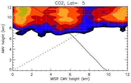
13 WIN WINV BASE HIST H2O CO2
14 Comparisons of Stereo and IR Heights Stereo Height IR Height Comments VIS image IR image Not same clouds => Poorer MISR-GOES htcomparison VIS image VIS + IR images VIS-IR pixel link => Better MISR-GOES htcomparison VIS image VIS image N/A IR image IR image
15 What s the height of a cloud pattern?
 Black (1982) Fujita and Dodge (1982)")
16 2-GOES Concept Shenk (1971) Apollo-6 Hasler (1981) Black (1982) Fujita and Dodge (1982) 60
 Stereo ht ~2 km higher Vertical growth: 4-8 m/s 30")
17 Stereo vs. IR Height from 2-GOES Retrievals Mack et al. (1983) Stereo ht ~2 km higher Vertical growth: 4-8 m/s 30 min.
18 Questions What is the equivalent height of an IR pattern (EHIR), or AMV from IR channels? Does the EHIR depend on the fraction of cold pixels in a pattern? Probably yes, based on pixel cluster studies. Is the stereo height of an IR pattern (SHIR) equal to EHIR? Probably yes, if no strong pattern deformation (i.e., growth/decay, vertical motion). If SHIR = EHIR: What cloud properties determine SHIR? What are the skills of using cloud properties for SHIR/EHIR assignment?
19 A Stereo Height Study with Simulated IR Cloud Images Domain: 512 x 512 km Grid size: 1 km Nadir and 45 views No background winds Pattern matching size: 20 km CRTM calculations: 11 μm T(z), H2O(z) Ice, Water, Rain, Graupel, Snow profiles Penetration depth 45

20

21

22 20x20 km
23 Top (Top + Base)/2 Mean TB Weighted Height 1 Weighted Height 2 Comparisons of Stereo Height with Model Cloud Heights Stereo Height (km)
24 Weighted Height 1 mass(z) = {Ice, Water, Rain, Graupel, Snow} Weighted Height 2 dtb/dm (z) = dtb/d{ice, Water, Rain, Graupel, Snow}
25 Summary MISR CMV and AMV often feature different heights because of better IR sensitivity to cirrus clouds. For the CMV and AMV with height differences < 3km (the majority of samples), these winds agree well with each other, both suggesting MERRA-2 reanalysis winds are too zonal in the cloudy region. Stereo heights from simulated IR cloud images are better represented by the height weighted by mass profiles.
26 Future Work Sentinel-3 SLSTR (Sea and Land Surface Temperature Radiometer), to pair with MODIS/VIIRS images for AMV and height MODIS/VIIRS 55 SLSTR Compare stereo height retrievals with those from various AMV height assignment methods
27 Differences Between VIS and IR Stereo in Cloud Pattern Matching VIS IR Pixel Resolution High Low Contrast of cloud pattern Dynamic range of intensity Penetration depth High Large Shallow Low N/A Deep Coverage Day Day + Night
How to display RGB imagery by SATAID
 How to display RGB imagery by SATAID Akihiro SHIMIZU Meteorological Satellite Center (MSC), Japan Meteorological Agency (JMA) Ver. 2015110500 RGB imagery on SATAID SATAID software has a function of overlapping
Assimilation of Himawari-8 Atmospheric Motion Vectors into the Numerical Weather Prediction Systems of Japan Meteorological Agency
 Assimilation of Himawari-8 Atmospheric Motion Vectors into the Numerical Weather Prediction Systems of Japan Meteorological Agency Koji Yamashita Japan Meteorological Agency kobo.yamashita@met.kishou.go.jp,
JMA s atmospheric motion vectors
 Prepared by JMA Agenda Item: WG II/6 Discussed in WG II JMA s atmospheric motion vectors This paper reports on the recent status of JMA's Atmospheric Motion Vectors (AMVs) from MTSAT-2 and MTSAT-1R, and
Day Microphysics RGB Nephanalysis in daytime. Meteorological Satellite Center, JMA
 Day Microphysics RGB Nephanalysis in daytime Meteorological Satellite Center, JMA What s Day Microphysics RGB? R : B04 (N1 0.86) Range : 0~100 [%] Gamma : 1.0 G : B07(I4 3.9) (Solar component) Range :
NUMERICAL EXPERIMENTS USING CLOUD MOTION WINDS AT ECMWF GRAEME KELLY. ECMWF, Shinfield Park, Reading ABSTRACT
 NUMERICAL EXPERIMENTS USING CLOUD MOTION WINDS AT ECMWF GRAEME KELLY ECMWF, Shinfield Park, Reading ABSTRACT Recent monitoring of cloud motion winds (SATOBs) at ECMWF has shown an improvement in quality.
MISR 17.6 km Gridded Cloud Motion Vectors: Overview and Assessment
 MISR 17.6 km Gridded Cloud Motion Vectors: Overview and Assessment Kevin Mueller, Michael Garay, Catherine Moroney, Veljko Jovanovic Jet Propulsion Laboratory Feb. 22, 2012 Height (m) Mean MISR July 2007
Lecture 19: Operational Remote Sensing in Visible, IR, and Microwave Channels
 MET 4994 Remote Sensing: Radar and Satellite Meteorology MET 5994 Remote Sensing in Meteorology Lecture 19: Operational Remote Sensing in Visible, IR, and Microwave Channels Before you use data from any
COMPARISON OF SIMULATED RADIANCE FIELDS USING RTTOV AND CRTM AT MICROWAVE FREQUENCIES IN KOPS FRAMEWORK
 COMPARISON OF SIMULATED RADIANCE FIELDS USING RTTOV AND CRTM AT MICROWAVE FREQUENCIES IN KOPS FRAMEWORK Ju-Hye Kim 1, Jeon-Ho Kang 1, Hyoung-Wook Chun 1, and Sihye Lee 1 (1) Korea Institute of Atmospheric
VALIDATION OF DUAL-MODE METOP AMVS
 VALIDATION OF DUAL-MODE METOP AMVS Ákos Horváth 1, Régis Borde 2, and Hartwig Deneke 1 1 Leibniz Institute for Tropospheric Research, Permoserstrasse 15, Leipzig, Germany 2 EUMETSAT, Eumetsat Allee 1,
Applications of the SEVIRI window channels in the infrared.
 Applications of the SEVIRI window channels in the infrared jose.prieto@eumetsat.int SEVIRI CHANNELS Properties Channel Cloud Gases Application HRV 0.7 Absorption Scattering
Current status and plans of JMA operational wind product
 Current status and plans of JMA operational wind product Kazuki Shimoji Japan Meteorological Agency / Meteorological Satellite Center 3-235, Nakakiyoto, Kiyose, Tokyo, Japan Abstract The Meteorological
RECENT UPGRADES OF AND ACTIVITIES FOR ATMOSPHERIC MOTION VECTORS AT JMA/MSC
 1 th International Winds Workshop, Tokyo, Japan, - ruary 1 RECENT UPGRADES OF AND ACTIVITIES FOR ATMOSPHERIC MOTION VECTORS AT JMA/MSC Ryo OYAMA Meteorological Satellite Center of Japan Meteorological
JMA s ATMOSPHERIC MOTION VECTORS In response to Action 40.22
 5 July 2013 Prepared by JMA Agenda Item: II/6 Discussed in WG II JMA s ATMOSPHERIC MOTION VECTORS In response to Action 40.22 This paper reports on the recent status of JMA's AMVs from MTSAT-2 and MTSAT-1R,
NWP SAF AMV monitoring: the 7th Analysis Report (AR7)
") Document NWPSAF-MO-TR-032 Version 1.0 24/05/16 NWP SAF AMV monitoring: the 7th Analysis Report (AR7) Francis Warrick Met Office, UK NWP SAF AMV monitoring: the 7th Analysis Report (AR7) Francis Warrick
Document NWPSAF-MO-TR-032 Version 1.0 24/05/16 NWP SAF AMV monitoring: the 7th Analysis Report (AR7) Francis Warrick Met Office, UK NWP SAF AMV monitoring: the 7th Analysis Report (AR7) Francis Warrick
NEW APPROACH FOR HEIGHT ASSIGNMENT AND STRINGENT QUALITY CONTROL TESTS FOR INSAT DERIVED CLOUD MOTION VECTORS. P. N. Khanna, S.
 NEW APPROACH FOR HEIGHT ASSIGNMENT AND STRINGENT QUALITY CONTROL TESTS FOR INSAT DERIVED CLOUD MOTION VECTORS P. N. Khanna, S. Prasad India Meteorological Department, Lodhi Road, New Delhi 110003. ABSTRACT
Application of Himawari-8 AHI Data to the GOES-R Rainfall Rate Algorithm
 Application of Himawari-8 AHI Data to the GOES-R Rainfall Rate Algorithm Yaping Li 1, Robert Kuligowski 2 and Yan Hao 1 1. IMSG at NOAA/NESDIS/STAR 2. NOAA/NESDIS/STAR, College Park, MD 1 GOES-R Baseline
GEOMETRIC CLOUD HEIGHTS FROM METEOSAT AND AVHRR. G. Garrett Campbell 1 and Kenneth Holmlund 2
 GEOMETRIC CLOUD HEIGHTS FROM METEOSAT AND AVHRR G. Garrett Campbell 1 and Kenneth Holmlund 2 1 Cooperative Institute for Research in the Atmosphere Colorado State University 2 EUMETSAT ABSTRACT Geometric
ASSESSING THE QUALITY OF HISTORICAL AVHRR POLAR WIND HEIGHT ASSIGNMENT
 ASSESSING THE QUALITY OF HISTORICAL AVHRR POLAR WIND HEIGHT ASSIGNMENT Richard Dworak + and Jeff Key* + Cooperative Institute for Meteorological Satellite Studies (CIMSS), University of Wisconsin Madison,
MSG system over view
 MSG system over view 1 Introduction METEOSAT SECOND GENERATION Overview 2 MSG Missions and Services 3 The SEVIRI Instrument 4 The MSG Ground Segment 5 SAF Network 6 Conclusions METEOSAT SECOND GENERATION
Meteorological Satellite Image Interpretations, Part III. Acknowledgement: Dr. S. Kidder at Colorado State Univ.
 Meteorological Satellite Image Interpretations, Part III Acknowledgement: Dr. S. Kidder at Colorado State Univ. Dates EAS417 Topics Jan 30 Introduction & Matlab tutorial Feb 1 Satellite orbits & navigation
DERIVING ATMOSPHERIC MOTION VECTORS FROM AIRS MOISTURE RETRIEVAL DATA
 DERIVING ATMOSPHERIC MOTION VECTORS FROM AIRS MOISTURE RETRIEVAL DATA David Santek 1, Sharon Nebuda 1, Christopher Velden 1, Jeff Key 2, Dave Stettner 1 1 Cooperative Institute for Meteorological Satellite
OPERATIONAL RETRIEVAL OF MSG AMVS USING THE NEW CCC METHOD FOR HEIGHT ASSIGNMENT.
 OPERATIONAL RETRIEVAL OF MSG AMVS USING THE NEW CCC METHOD FOR HEIGHT ASSIGNMENT. M. Doutriaux-Boucher, M. Carranza, A. de Smet, G. Dew, and R. Borde Eumetsat, Darmstadt, Germany. Present AMV retrieval
Feature-tracked 3D Winds from Satellite Sounders: Derivation and Impact in Global Models
 Feature-tracked 3D Winds from Satellite Sounders: Derivation and Impact in Global Models David Santek, Anne-Sophie Daloz 1, Samantha Tushaus 1, Marek Rogal 1, Will McCarty 2 1 Space Science and Engineering
NESDIS Polar (Region) Products and Plans. Jeff Key NOAA/NESDIS Madison, Wisconsin USA
 Products and Plans. Jeff Key NOAA/NESDIS Madison, Wisconsin USA") NESDIS Polar (Region) Products and Plans Jeff Key NOAA/NESDIS Madison, Wisconsin USA WMO Polar Space Task Group, 2 nd meeting, Geneva, 12 14 June 2012 Relevant Missions and Products GOES R ABI Fractional
NESDIS Polar (Region) Products and Plans Jeff Key NOAA/NESDIS Madison, Wisconsin USA WMO Polar Space Task Group, 2 nd meeting, Geneva, 12 14 June 2012 Relevant Missions and Products GOES R ABI Fractional
Diagnosis of Relative Humidity Changes in a Warmer Climate Using Tracers of Last Saturation
 Diagnosis of Relative Humidity Changes in a Warmer Climate Using Tracers of Last Saturation 8 March, 2011 Jonathon Wright Department of Applied Mathematics & Theoretical Physics University of Cambridge
The role of GPS-RO at ECMWF" ! COSMIC Data Users Workshop!! 30 September 2014! !!! ECMWF
 The role of GPS-RO at ECMWF"!!!! COSMIC Data Users Workshop!! 30 September 2014! ECMWF WE ARE Intergovernmental organisation! 34 Member and Cooperating European states! 270 staff at ECMWF, in Reading,
Steve Ackerman, R. Holz, R Frey, S. Platnick, A. Heidinger, and a bunch of others.
 Steve Ackerman, R. Holz, R Frey, S. Platnick, A. Heidinger, and a bunch of others. Outline Using CALIOP to Validate MODIS Cloud Detection, Cloud Height Assignment, Optical Properties Clouds and Surface
CHAPTER 9 TECHNIQUES FOR DETERMINING ATMOSPHERIC MOTIONS
 CHAPTER 9 TECHNIQUES FOR DETERMINING ATMOSPHERIC MOTIONS 9.1 Atmospheric Motion There are a variety of forces influencing the motion of an air parcel in the atmosphere. Considering that the earth is a
Relationships between the North Atlantic Oscillation and isentropic water vapor transport into the lower stratosphere
 1/18 Relationships between the North Atlantic Oscillation and isentropic water vapor transport into the lower stratosphere Jonathon Wright and Seok-Woo Son Department of Applied Physics & Applied Mathematics
Microwave Limb Sounder Observations of Polar Middle Atmosphere: Decadal and Inter-annual Variability
 Microwave Limb Sounder Observations of Polar Middle Atmosphere: Decadal and Inter-annual Variability Jae N. Lee 1, Dong L. Wu 2, Alexander ozone Ruzmaikin 1, Gloria J. Manney 1, and Sultan Hameed 4 1.
ASSESSMENT AND APPLICATIONS OF MISR WINDS
 ASSESSMENT AND APPLICATIONS OF MISR WINDS Yanqiu Zhu Science Applications International Corporation 4600 Powder Mill Road, Beltsville, Maryland 20705 Lars Peter Riishojgaard Global Modeling and Assimilation
Remote Sensing of Precipitation
 Lecture Notes Prepared by Prof. J. Francis Spring 2003 Remote Sensing of Precipitation Primary reference: Chapter 9 of KVH I. Motivation -- why do we need to measure precipitation with remote sensing instruments?
TOWARDS IMPROVED HEIGHT ASSIGNMENT AND QUALITY CONTROL OF AMVS IN MET OFFICE NWP
 Proceedings for the 13 th International Winds Workshop 27 June - 1 July 2016, Monterey, California, USA TOWARDS IMPROVED HEIGHT ASSIGNMENT AND QUALITY CONTROL OF AMVS IN MET OFFICE NWP James Cotton, Mary
IMPACT STUDIES OF HIGHER RESOLUTION COMS AMV IN THE KMA NWP SYSTEM
 Proceedings for the 13 th International Winds Workshop 27 June - 1 July 2016, Monterey, California, USA IMPACT STUDIES OF HIGHER RESOLUTION COMS AMV IN THE KMA NWP SYSTEM Jung-Rim Lee, Hyun-Cheol Shin,
MSG Indian Ocean Data Coverage (IODC) Jochen Grandell & Sauli Joro
 Jochen Grandell & Sauli Joro") MSG Indian Ocean Data Coverage (IODC) Jochen Grandell & Sauli Joro 1 EUM/STG-SWG/42/17/VWG/03 v1, 7 8 Mach 2017 Topics Introduction MSG-IODC Overall Project Schedule Status Product validation Products
MSG Indian Ocean Data Coverage (IODC) Jochen Grandell & Sauli Joro 1 EUM/STG-SWG/42/17/VWG/03 v1, 7 8 Mach 2017 Topics Introduction MSG-IODC Overall Project Schedule Status Product validation Products
Masahiro Kazumori, Takashi Kadowaki Numerical Prediction Division Japan Meteorological Agency
 Development of an all-sky assimilation of microwave imager and sounder radiances for the Japan Meteorological Agency global numerical weather prediction system Masahiro Kazumori, Takashi Kadowaki Numerical
TC intensity estimation using Satellite data at JMA
 SECOND INTERNATIONAL WORKSHOP ON SATELLITE ANALYSIS OF TROPICAL CYCLONES (IWSATC-II) TC intensity estimation using Satellite data at JMA Topics: 1) Estimation of TC central pressure using Microwave Sounder
Impact of the 2002 stratospheric warming in the southern hemisphere on the tropical cirrus clouds and convective activity
 The Third International SOWER meeting,, Lake Shikotsu,, July 18-20, 2006 1 Impact of the 2002 stratospheric warming in the southern hemisphere on the tropical cirrus clouds and convective activity Eguchi,
Global Energy Balance: Greenhouse Effect
 Global Energy Balance: Greenhouse Effect Atmospheric Composition & Structure Physical Causes of Greenhouse Effects Chapter 3: 44 48. Atmospheric Composition Why does water vapor vary so much? Saturation
CLIMATE AND CLIMATE CHANGE MIDTERM EXAM ATM S 211 FEB 9TH 2012 V1
 CLIMATE AND CLIMATE CHANGE MIDTERM EXAM ATM S 211 FEB 9TH 2012 V1 Name: Student ID: Please answer the following questions on your Scantron Multiple Choice [1 point each] (1) The gases that contribute to
STATUS OF JAPANESE METEOROLOGICAL SATELLITES AND RECENT ACTIVITIES OF MSC
 STATUS OF JAPANESE METEOROLOGICAL SATELLITES AND RECENT ACTIVITIES OF MSC Daisaku Uesawa Meteorological Satellite Center, Japan Meteorological Agency Abstract MTSAT-1R is the current operational Japanese
WRF Model Simulated Proxy Datasets Used for GOES-R Research Activities
 WRF Model Simulated Proxy Datasets Used for GOES-R Research Activities Jason Otkin Cooperative Institute for Meteorological Satellite Studies Space Science and Engineering Center University of Wisconsin
STATISTICAL ANALYSIS ON SEVERE CONVECTIVE WEATHER COMBINING SATELLITE, CONVENTIONAL OBSERVATION AND NCEP DATA
 12.12 STATISTICAL ANALYSIS ON SEVERE CONVECTIVE WEATHER COMBINING SATELLITE, CONVENTIONAL OBSERVATION AND NCEP DATA Zhu Yaping, Cheng Zhoujie, Liu Jianwen, Li Yaodong Institute of Aviation Meteorology
CURRENT STATUS OF OPERATIONAL WIND PRODUCT IN JMA/MSC
 Proceedings for the 13 th International Winds Workshop 27 June - 1 July 2016, Monterey, California, USA CURRENT STATUS OF OPERATIONAL WIND PRODUCT IN JMA/MSC Kazuki Shimoji and Kenichi Nonaka JMA/MSC,
Sensitivity Study of the MODIS Cloud Top Property
 Sensitivity Study of the MODIS Cloud Top Property Algorithm to CO 2 Spectral Response Functions Hong Zhang a*, Richard Frey a and Paul Menzel b a Cooperative Institute for Meteorological Satellite Studies,
CTTH Cloud Top Temperature and Height
 CTTH Cloud Top Temperature and Height 15 th June 2004 Madrid Hervé Le Gléau and Marcel Derrien Météo-France / CMS lannion 1 Plan of CTTH presentation Algorithms short description Some examples Planned
Multi-Satellite 3D Winds Land/Atmosphere Requirements
 Multi-Satellite 3D Winds Land/Atmosphere Requirements James L Carr* Carr Astronautics 6404 Ivy Lane, #333 Greenbelt, MD 20770 August 22-23, 2017 NOAA Workshop *jcarr@carrastro.com Multi-Satellite 3D Winds
Recent developments in the CMVs derived from KALPANA-1 AND INSAT-3A Satellites and their impacts on NWP Model.
 Recent developments in the CMVs derived from KALPANA-1 AND INSAT-3A Satellites and their impacts on NWP Model. By Devendra Singh, R.K.Giri and R.C.Bhatia India Meteorological Department New Delhi-110 003,
11 days (00, 12 UTC) 132 hours (06, 18 UTC) One unperturbed control forecast and 26 perturbed ensemble members. --
 132 hours (06, 18 UTC) One unperturbed control forecast and 26 perturbed ensemble members. --") APPENDIX 2.2.6. CHARACTERISTICS OF GLOBAL EPS 1. Ensemble system Ensemble (version) Global EPS (GEPS1701) Date of implementation 19 January 2017 2. EPS configuration Model (version) Global Spectral Model
APPENDIX 2.2.6. CHARACTERISTICS OF GLOBAL EPS 1. Ensemble system Ensemble (version) Global EPS (GEPS1701) Date of implementation 19 January 2017 2. EPS configuration Model (version) Global Spectral Model
THE POLAR WIND PRODUCT SUITE
 THE POLAR WIND PRODUCT SUITE Jeffrey Key 1, David Santek 2, Christopher Velden 2, Jaime Daniels 1, Richard Dworak 2 1 Center for Satellite Applications and Research, NOAA/NESDIS 2 Cooperative Institute
The MODIS Cloud Data Record
 The MODIS Cloud Data Record Brent C. Maddux 1,2 Steve Platnick 3, Steven A. Ackerman 1 Paul Menzel 1, Kathy Strabala 1, Richard Frey 1, 1 Cooperative Institute for Meteorological Satellite Studies, 2 Department
Atmospheric Motion Vectors from Kalpana-1: An ISRO status
 Atmospheric Motion Vectors from Kalpana-1: An ISRO status Sanjib Kr. Deb, Inderpreet Kaur, C. M. Kishtawal and P. K. Pal Atmospheric and Oceanic Sciences Group Space Applications Centre Indian Space Research
Diurnal cycles of precipitation, clouds, and lightning in the tropics from 9 years of TRMM observations
 GEOPHYSICAL RESEARCH LETTERS, VOL. 35, L04819, doi:10.1029/2007gl032437, 2008 Diurnal cycles of precipitation, clouds, and lightning in the tropics from 9 years of TRMM observations Chuntao Liu 1 and Edward
Introducing Atmospheric Motion Vectors Derived from the GOES-16 Advanced Baseline Imager (ABI)
") Introducing Atmospheric Motion Vectors Derived from the GOES-16 Advanced Baseline Imager (ABI) Jaime Daniels NOAA/NESDIS, Center for Satellite Applications and Research Wayne Bresky, Andrew Bailey, Americo
Introducing Atmospheric Motion Vectors Derived from the GOES-16 Advanced Baseline Imager (ABI) Jaime Daniels NOAA/NESDIS, Center for Satellite Applications and Research Wayne Bresky, Andrew Bailey, Americo
1. The frequency of an electromagnetic wave is proportional to its wavelength. a. directly *b. inversely
 CHAPTER 3 SOLAR AND TERRESTRIAL RADIATION MULTIPLE CHOICE QUESTIONS 1. The frequency of an electromagnetic wave is proportional to its wavelength. a. directly *b. inversely 2. is the distance between successive
Current Status of COMS AMV in NMSC/KMA
 Current Status of COMS AMV in NMSC/KMA Eunha Sohn, Sung-Rae Chung, Jong-Seo Park Satellite Analysis Division, NMSC/KMA soneh0431@korea.kr COMS AMV of KMA/NMSC has been produced hourly since April 1, 2011.
Extratropical and Polar Cloud Systems
 Extratropical and Polar Cloud Systems Gunilla Svensson Department of Meteorology & Bolin Centre for Climate Research George Tselioudis Extratropical and Polar Cloud Systems Lecture 1 Extratropical cyclones
Advanced Satellite Remote Sensing: Microwave Remote Sensing. August 11, 2011
 Advanced Satellite Remote Sensing: Microwave Remote Sensing FIU HRSSERP Internship August 11, 2011 What can Microwave Satellites Measure? Ocean Surface Wind Speed SeaIce Concentration, Edge, and age Precipitation
OSI SAF SST Products and Services
 OSI SAF SST Products and Services Pierre Le Borgne Météo-France/DP/CMS (With G. Legendre, A. Marsouin, S. Péré, S. Philippe, H. Roquet) 2 Outline Satellite IR radiometric measurements From Brightness Temperatures
The water vapour channels of SEVIRI (Meteosat). An introduction
. An introduction") The water vapour channels of SEVIRI (Meteosat). An introduction jose.prieto@eumetsat.int Cachoeira P. July 2006 Formats 1.5 1 Objectives 2 Describe the characteristics of WV channels on board of SEVIRI
The water vapour channels of SEVIRI (Meteosat). An introduction jose.prieto@eumetsat.int Cachoeira P. July 2006 Formats 1.5 1 Objectives 2 Describe the characteristics of WV channels on board of SEVIRI
Assimilation of Himawari-8 data into JMA s NWP systems
 Assimilation of Himawari-8 data into JMA s NWP systems Masahiro Kazumori, Koji Yamashita and Yuki Honda Numerical Prediction Division, Japan Meteorological Agency 1. Introduction The new-generation Himawari-8
A Novel Cirrus Cloud Retrieval Method For GCM High Cloud Validations
 A Novel Cirrus Cloud Retrieval Method For GCM High Cloud Validations David Mitchell Anne Garnier Melody Avery Desert Research Institute Science Systems & Applications, Inc. NASA Langley Reno, Nevada Hampton,
The Role of Post Cold Frontal Cumulus Clouds in an Extratropical Cyclone Case Study
 The Role of Post Cold Frontal Cumulus Clouds in an Extratropical Cyclone Case Study Amanda M. Sheffield and Susan C. van den Heever Colorado State University Dynamics and Predictability of Middle Latitude
OCND Convective Cloud Heights
 OCND Convective Cloud Heights NRL Satellite Meteorological Applications Monterey, CA Outline: I. Background II. Outline of Method a. North/South Domains b. Strengths/Weaknesses III. Protocols of the Aviation
Fluid Circulation Review. Vocabulary. - Dark colored surfaces absorb more energy.
 Fluid Circulation Review Vocabulary Absorption - taking in energy as in radiation. For example, the ground will absorb the sun s radiation faster than the ocean water. Air pressure Albedo - Dark colored
Feature-tracked 3D Winds from Satellite Sounders: Derivation and Impact in Global Models
 Feature-tracked 3D Winds from Satellite Sounders: Derivation and Impact in Global Models David Santek 1, A.-S. Daloz 1, S. Tushaus 1, M. Rogal 1, W. McCarty 2 1 Space Science and Engineering Center/University
Clouds on Mars Cloud Classification
 Lecture Ch. 8 Cloud Classification Descriptive approach to clouds Drop Growth and Precipitation Processes Microphysical characterization of clouds Complex (i.e. Real) Clouds Examples Curry and Webster,
Introduction to Atmospheric Circulation
 Introduction to Atmospheric Circulation Start rotating table Cloud Fraction Dice Results from http://eos.atmos.washington.edu/erbe/ from http://eos.atmos.washington.edu/erbe/ from http://eos.atmos.washington.edu/erbe/
The exceptional Arctic winter 2005/06
 SPARC data assimilation workshop, 2-4 October 2006 The exceptional Arctic winter 2005/06 An example to investigate polar processes using different assimilations systems 1, Gloria Manney 2,3, Steven Pawson
Reprocessed Satellite Data Products for Assimilation and Validation
 Reprocessed Satellite Data Products for Assimilation and Validation Leo van de Berg, Bertrand Theodore EUMETSAT Page 1 Historical Presentation Contents Results of Eumetsat ERA-40 Activities Lessons Learned
Wind tracing from SEVIRI clear and overcast radiance assimilation
 Wind tracing from SEVIRI clear and overcast radiance assimilation Cristina Lupu and Tony McNally ECMWF, Reading, UK Slide 1 Outline Motivation & Objective Analysis impact of SEVIRI radiances and cloudy
NOAA CONSIDERATION OF PRODUCING AMV WIND PRODUCTS OVER THE POLES In response to CGMS Action 34.21
 Prepared by Jeff Key Agenda Item: II/5 Discussed in WG II NOAA CONSIDERATION OF PRODUCING AMV WIND PRODUCTS OVER THE POLES In response to CGMS Action 34.21 This paper summarizes current wind products from
u g z = g T y (1) f T Margules Equation for Frontal Slope
 f T Margules Equation for Frontal Slope") Margules Equation for Frontal Slope u g z = g f T T y (1) Equation (1) is the thermal wind relation for the west wind geostrophic component of the flow. For the purposes of this derivation, we assume that
Margules Equation for Frontal Slope u g z = g f T T y (1) Equation (1) is the thermal wind relation for the west wind geostrophic component of the flow. For the purposes of this derivation, we assume that
Day Snow-Fog RGB Detection of low-level clouds and snow/ice covered area
 JMA Day Snow-Fog RGB Detection of low-level clouds and snow/ice covered area Meteorological Satellite Center, JMA What s Day Snow-Fog RGB? R : B04 (N1 0.86) Range : 0~100 [%] Gamma : 1.7 G : B05 (N2 1.6)
Satellite Constraints on Arctic-region Airborne Particles Ralph Kahn NASA Goddard Space Flight Center
 Satellite Constraints on Arctic-region Airborne Particles Ralph Kahn NASA Goddard Space Flight Center Sea of Okhotsk, MODIS image Feb. 6, 2007, NASA Earth Observatory Arctic Aerosol Remote Sensing Overview
San Jose State University. From the SelectedWorks of Minghui Diao
 San Jose State University From the SelectedWorks of Minghui Diao November 14, 2012 Water Vapor and Temperature Comparisons Between AIRS/AMSU-A and In Situ Aircraft Observations From 87 N to 67 S and Sensitivities
Cloud masking as cross-cutting issue
 Cloud masking as cross-cutting issue Presentation to CEOS/WGCV activity project planning meeting Rainer Hollmann, Cornelia Schlundt, Satellite based Climate Monitoring Deutscher Wetterdienst Outline Need
Air Masses, Fronts, Storm Systems, and the Jet Stream
 Air Masses, Fronts, Storm Systems, and the Jet Stream Air Masses When a large bubble of air remains over a specific area of Earth long enough to take on the temperature and humidity characteristics of
Assimilation of Geostationary WV Radiances within the 4DVAR at ECMWF
 Assimilation of Geostationary WV Radiances within the 4DVAR at ECMWF Christina Köpken Graeme Kelly, Jean-Noël Thépaut ECMWF EUMETSAT Fellowship ITSC-XII Lorne, Australia, 27 February - 5 March 2002 Assimilation
Using VIIRS Land Surface Temperature to Evaluate NCEP North American Mesoscale Model (NAM) Forecast
 Forecast") Using VIIRS Land Surface Temperature to Evaluate NCEP North American Mesoscale Model (NAM) Forecast Zhuo Wang (University of Maryland) Yunyue Yu (NOAA/NESDIS/STAR) Peng Yu (University of Maryland) Yuling
Using VIIRS Land Surface Temperature to Evaluate NCEP North American Mesoscale Model (NAM) Forecast Zhuo Wang (University of Maryland) Yunyue Yu (NOAA/NESDIS/STAR) Peng Yu (University of Maryland) Yuling
Journal of the Meteorological Society of Japan, Vol. 75, No. 1, pp , Day-to-Night Cloudiness Change of Cloud Types Inferred from
 Journal of the Meteorological Society of Japan, Vol. 75, No. 1, pp. 59-66, 1997 59 Day-to-Night Cloudiness Change of Cloud Types Inferred from Split Window Measurements aboard NOAA Polar-Orbiting Satellites
Polar winds from highly elliptical orbiting satellites: a new perspective
 Polar winds from highly elliptical orbiting satellites: a new perspective 10 th International Winds Workshop Tokyo, Japan, Feb -6, 010 L. Garand 1, N. Wagneur 1, R. Sarrazin 1, D. Santek, J. Key 1 Environment
Signatures of Monsoon Overshooting Convection in MLS Water Vapor
 Jet Propulsion Laboratory California Institute of Technology Signatures of Monsoon Overshooting Convection in MLS Water Vapor Michael J. Schwartz, Nathaniel J. Livesey, Michelle L. Santee, Tao Wang Workshop
Go With the Flow From High to Low Investigating Isobars
 Go With the Flow From High to Low Investigating Isobars Science 10 Mrs. Purba Air Masses The air over a warm surface can be heated, causing it to rise above more dense air. The result is the formation
A New Numerical Weather Prediction Approach to the NDFD's Sky Cover Grid
 A New Numerical Weather Prediction Approach to the NDFD's Sky Cover Grid Jordan Gerth Graduate Research Assistant Cooperative Institute for Meteorological Satellite Studies (CIMSS) and Department of Atmospheric
Evaluation of Satellite and Reanalysis Products of Downward Surface Solar Radiation over East Asia
 International Workshop on Land Use/Cover Changes and Air Pollution in Asia August 4-7th, 2015, Bogor, Indonesia Evaluation of Satellite and Reanalysis Products of Downward Surface Solar Radiation over
Lecture 7: The Monash Simple Climate
 Climate of the Ocean Lecture 7: The Monash Simple Climate Model Dr. Claudia Frauen Leibniz Institute for Baltic Sea Research Warnemünde (IOW) claudia.frauen@io-warnemuende.de Outline: Motivation The GREB
AMVs in the ECMWF system:
 AMVs in the ECMWF system: Highlights of the operational and research activities Kirsti Salonen and Niels Bormann Slide 1 Number of used AMVs Look back: how the use of AMVs has evolved NOAA-15,-16,-18,-19
Which AMVs for which model? Chairs: Mary Forsythe, Roger Randriamampianina IWW14, 24 April 2018
 Which AMVs for which model? Chairs: Mary Forsythe, Roger Randriamampianina IWW14, 24 April 2018 Thanks to Regis Borde, EUMETSAT James Cotton, Met Office Javier Garcia-Pereda, NWC SAF Graeme Kelly, Met
CCI achievements atmosphere / surface
 CCI achievements atmosphere / surface aerosol CCI SST CCI cloud CCI ozone CCI + a bonus discussion : can these CCI provide insights / explanations to the surface T hiatus? aerosol CCI at the start there
International TOVS Study Conference-XIV Proceedings. Liu zhe
 Analysis of typhoon rananim using ATOVS retrieval products Liu zhe Institute of Meteorology, PLA University of Science and Technology, Nanjing, China Han zhigang Zhao zengliang Beijing Institute of Applied
Introduction. Recent changes in the use of AMV observations. AMVs over land. AMV impact study. Use of Scatterometer data (Ascat, Oceansat-2)
") Recent progress in using satellite winds at the German Weather Service Alexander Cress, Heinz Werner Bitzer German Weather Service, Offenbach am Main, Germany, email: Alexander.Cress@dwd.de Introduction
Recent progress in using satellite winds at the German Weather Service Alexander Cress, Heinz Werner Bitzer German Weather Service, Offenbach am Main, Germany, email: Alexander.Cress@dwd.de Introduction
THE FEASIBILITY OF EXTRACTING LOWLEVEL WIND BY TRACING LOW LEVEL MOISTURE OBSERVED IN IR IMAGERY OVER CLOUD FREE OCEAN AREA IN THE TROPICS
 THE FEASIBILITY OF EXTRACTING LOWLEVEL WIND BY TRACING LOW LEVEL MOISTURE OBSERVED IN IR IMAGERY OVER CLOUD FREE OCEAN AREA IN THE TROPICS Toshiro Ihoue and Tetsuo Nakazawa Meteorological Research Institute
Comparison of NASA AIRS and MODIS Land Surface Temperature and Infrared Emissivity Measurements from the EOS AQUA platform
 Comparison of NASA AIRS and MODIS Land Surface Temperature and Infrared Emissivity Measurements from the EOS AQUA platform Robert Knuteson, Steve Ackerman, Hank Revercomb, Dave Tobin University of Wisconsin-Madison
2. Fargo, North Dakota receives more snow than Charleston, South Carolina.
 2015 National Tournament Division B Meteorology Section 1: Weather versus Climate Chose the answer that best answers the question 1. The sky is partly cloudy this morning in Lincoln, Nebraska. 2. Fargo,
The Earth s Atmosphere-II. GEOL 1350: Introduction To Meteorology
 The Earth s Atmosphere-II GEOL 1350: Introduction To Meteorology 1 Vertical Structure of Atmosphere Vertical profile of the atmosphere reveals that it can be divided into a series of layers. Each layer
CONSTRUCTION OF CLOUD TRAJECTORIES AND MOTION OF CIRRUS CLOUDS AND WATER VAPOUR STRUCTURES
 CONSTRUCTION OF CLOUD TRAJECTORIES AND MOTION OF CIRRUS CLOUDS AND WATER VAPOUR STRUCTURES André SZANTAI +, Michel DESBOIS +, Laurence PICON +, Henri LAURENT *, Françoise DESALMAND + + Laboratoire de Météorologie
The ECMWF coupled data assimilation system
 The ECMWF coupled data assimilation system Patrick Laloyaux Acknowledgments: Magdalena Balmaseda, Kristian Mogensen, Peter Janssen, Dick Dee August 21, 214 Patrick Laloyaux (ECMWF) CERA August 21, 214
Recent Changes in the Derivation of Geostationary AMVs at EUMETSAT. Manuel Carranza Régis Borde Marie Doutriaux-Boucher
 Recent Changes in the Derivation of Geostationary AMVs at EUMETSAT Manuel Carranza Régis Borde Marie Doutriaux-Boucher Summary Introduction to EUMETSAT s geostationary AMVs Recent changes: Cross-Correlation
Inter-tropical Convergence Zone (ITCZ) analysis using AIRWAVE retrievals of TCWV from (A)ATSR series and potential extension of AIRWAVE to SLSTR
 analysis using AIRWAVE retrievals of TCWV from (A)ATSR series and potential extension of AIRWAVE to SLSTR") Inter-tropical Convergence Zone (ITCZ) analysis using AIRWAVE retrievals of TCWV from (A)ATSR series and potential extension of AIRWAVE to SLSTR Enzo Papandrea (SERCO, CNR-ISAC, Enzo.Papandrea@serco.com)
Inter-tropical Convergence Zone (ITCZ) analysis using AIRWAVE retrievals of TCWV from (A)ATSR series and potential extension of AIRWAVE to SLSTR Enzo Papandrea (SERCO, CNR-ISAC, Enzo.Papandrea@serco.com)