Use of GIS in Plotting Early 19 th Century Hurricane Information (Part 2)
|
|
|
- Clarence Rogers
- 5 years ago
- Views:
Transcription
1 Use of GIS in Plotting Early 19 th Century Hurricane Information (Part 2) Brian H. Bossak* and James B. Elsner Department of Geography Florida State University *Current Address: U.S. Geological Survey Center for Coastal and Watershed Studies St. Petersburg, FL Telephone: (727) ex. 3046
2 INTRODUCTION. Hurricanes are among the most dangerous and damaging storms on Earth (Malilay 1997). They have the potential to cause as much damage and loss of life as earthquakes (Diaz and Pulwarty 1997). Estimates put the average annual cost of hurricane damage in the United States at $4.8 billion dollars (Pielke and Landsea 1998). Encompassing a diameter of between 200 and 1300 kilometers and possessing wind speeds exceeding 33 ms 1 ( 74 mph), hurricanes are capable of inflicting widespread destruction. As a consequence, it is important to understand how often hurricanes occur and at what intensity. Exposure to hurricane damage is a function of the population at risk, property at risk, and the level of preparedness (Pielke and Pielke 1997). There are more than 45 million people living along the coast from Brownsville, Texas to Eastport, Maine (Elsner and Kara 1999). As coastal population increases, the economic damage potential increases as well. For example, $3.1 trillion worth of coastal property was insured in 1993, compared to $1.9 trillion in 1988 (Pielke and Pielke 1997). Thus hurricanes pose a serious threat to the United States in both economic and human terms and better long term risk assessments are needed. However, hurricane climate research is based largely on records spanning only the last 100 years or so (Elsner et al. 2000; Landsea et al. 1996). Accounts of hurricanes exist in a variety of documents that include compendiums sorted by region and date, documents with records for individual states, and personal research. Sources for these works include direct observations, ship records, newspaper accounts, personal letters and governmental archive reports. This note reflects on efforts to collate available documental evidence of past hurricanes over the period This period represents the years prior to the NOAA best track dataset (Jarvinen et al. 1984), which begins with the year The purpose is to bring together historical archives into a single electronic reference, and to add value to the archives by plotting the information on maps. The result is a historical hurricane impact tool (HHIT) that can be used for scientific investigations of hurricane climate variability and change and that can serve as the basis for a reanalysis of early American hurricanes. EARLY AMERICAN HURRICANES. David Ludlum s 1963 monograph entitled Early American Hurricanes: is a compilation of high quality textual summaries of tropical cyclone activity over the western North Atlantic and Gulf of Mexico (Sharkov 2000). Major sources include Garriott (1900), Fassig (1913), Tannehill (1956) and Dunn and Miller (1960), which are based on the work of Poey (1855) and others. The monograph contains local newspaper accounts of damage reports from ships that were published in newspapers, personal letters and diaries, as well as records in archives that provide descriptions and dates for the storms. Some of the reports include meteorological observations. For example, below is an excerpt from the post surgeon at Ft. Brooke (near present day Tampa, FL) during the September 25, 1848 hurricane: 2
3 The tide rose 15 feet above low water the water commenced rising very fast at 10 A.M. and continued to rise until 2 P.M. The surgeon also noted t he fall of the barometer from a prestorm reading of at 0900/24 th and at 2100 to a low of sometime prior to 1500/25 th, indicative of a storm of the severest type. By 1500 the glass had recovered to an d the wind was coming out of the south. (Ludlum, 1963, p.154) Ludlum (1963) is the primary source document for the HHIT. However, we also include data from more recent historical chronologies compiled by Ho (1989), Barnes (1998, 2001), Sandrik (1999), Cotterly (1999), Forty Sixth Weather Squadron (1999), Roth (1998, 2000), Roth and Cobb (2001), and Prokop (2001). These works contain additional information about some of the storms listed in Ludlum (1963) as well as notes on storms not mentioned. A GIS TOOL. Overview. Information from Ludlum (1963) and others is used to construct a series of mapped accounts of tropical cyclones from the period , inclusive, using a Geographic Information System (GIS). The HHIT is organized chronologically by year. Upon opening the GIS product and selecting the HHIT directory, a listing of years between 1800 and 1850 appears, appended with a suffix (apr) identifying the file as a GIS project. For each year, the tropical cyclones are organized chronologically by landfall date. Thirty seven of the 51 years had evidence of at least one tropical cyclone. The HHIT includes evidence from 90 tropical cyclones during the 51 year period. Table 1 provides hurricane count statistics in 50 year periods. Seasonal distributions of tropical storm counts appear similar among the periods. The most active year prior to 1851 was 1837 with 10 tropical cyclones, 6 of which likely made direct landfall along the U.S. coast. The second most active year was 1844, with 8 tropical cyclones and 4 landfalls. Callouts. Descriptive information regarding hurricanes and tropical storms is input as callout boxes over base maps of the United States. The majority of callouts contain information verbatim from the source documents, with some minor paraphrasing to make the descriptions more compact. The boxes are positioned on the map near the geographic location described within and include a pointer to the location, if known. Instances in which the location is unknown utilize a text box rather than a callout box. Text and callout boxes are scale dependent: changing the map scale changes the text scale in reciprocity. The layout (the view of each storm prepared for hard copy) includes a storm summary taken directly from the source documents. Statements not garnered from the original source documents are included in separate text boxes. User s Manual. The HHIT uses Environmental Systems Research Institute s (ESRI) ArcView GIS software (version 3.1). Therefore, any user of the original project must have ArcView 3.1 or later installed on a PC in order to access the original HHIT. The project shapefiles (the files used by the GIS to display the hurricane information) must be installed to the user s hard disk. Once a project is selected, the project opens and displays the various menu icons available to the user. The two most commonly used menu icons are the Vi ews and the Layouts. The Views ar e the core of each project, and contain the 3
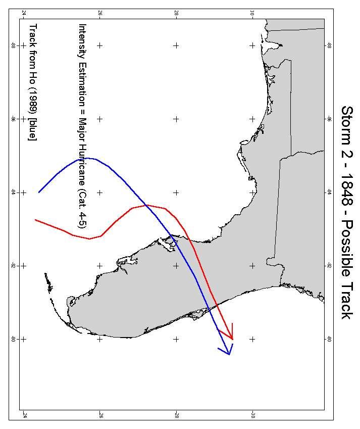
4 descriptive information relating to the storm. The V iews also contain the estimated track of the storm. They are chronologically organized by date of influence to the United States. The L ayouts ar e designed as hardcopy layout tools. This is where a user will find finished descriptive maps, track maps, intensity estimations, and further storm descriptions. Within the Vi ews a re callout descriptions for each storm. Upon opening a Vi ew, the user sees a map display containing descriptive information for each storm and a selection of T hemes from which to choose. Source documents are treated as separate T hemes f or each storm (Figure 1). The Views involving tracks have one Theme titled Track. Toggling the checkbox for this Theme will alternately display and hide from view the track of the storm. Where no track is specified, Track Unspecified will appear in the Vi ew. Estimated storm intensities at landfall are also included, but are present only in the Layout fo r each storm. The digital nature of the HHIT allows for editing and modification. For example, new documentary accounts of a particular storm can be added in the tool by adding a new T heme. Entir ely new storms can be added by creating a new View. Addition al years can be added by creating new projects with separate views for each storm. Map Interpretation. Extreme caution must be exercised when interpreting information from these maps. Although we include storm track and intensity estimates for some storms, the potential for larger errors in track location and storm intensity is high. A preponderance of evidence can lead to a more definitive estimation of track and/or intensity for some well documented cases. For most storms, however, track and intensity estimates can be considered baseline approximations. While these are not depicted for the tracks themselves, the intensity estimations provided in the current version of HHIT should be considered only within ±2 Saffir Simpson categories. They provide a starting point for further track estimation and intensity studies. Three types of tracks are given in the HHIT. Those that are taken directly from Ho (1989) are colored blue, those taken directly from Tannehill (1956) are colored green, and those that are based on our analysis are colored red. Where estimates are possible, tracks are modified from solid to dotted lines to indicate weakening to tropical storm strength. Figure 2 is a map showing tracks depicted for the 1848 Tampa Bay hurricane. SUMMARY. Hurricane climate research is based on records from the past 100 years or so. The official U.S. hurricane record currently extends back to To better understand these rare, but potentially catastrophic events it is important to have the longest possible records. Combining information available from historical documents, tropical cyclone impacts in the United States are mapped for the years using a GIS. The historical hurricane information tool (HHIT) is based on ESRI s ArcView GIS. Storm impacts in the United States and to vessels in adjacent coastal waters are manually input on a geographic map using callouts. Descriptive information such as damage reports, meteorological observations, and ship reports are included. Individual historical sources are treated as separate themes for each storm. Storms are listed chronologically by year. The collation of existing historical information about early 19 th 4
5 century hurricanes into a single electronic source provides accessibility to the use of such information by scientists trying to understand hurricane climate variability and change. The digital nature of the HHIT makes it well suited for modification. For example, the inclusion of information about storms in the HHIT available from near coastal ships (see EC Framework V Project, 2003) would be a valuable addition. The data contained within the HHIT needs to be treated with caution, but it is not necessary to completely ignore it. In fact, Elsner and Bossak (2001) and Elsner and Jagger (2004) demonstrate how to combine earlier records of lesser accuracy with later records of greater accuracy in making hurricane climate forecasts, which is of importance for insurance and reinsurance contracts (Michaels et al. 1997). The HHIT GIS tool is available through the Hurricane Climate Institute at Florida State University in a CD ROM version and a viewable only web version ( ACKNOWLEDGMENTS. The research is supported by NSF BCS The views expressed in this paper are those of the authors and do not necessarily reflect the official policy of the NSF. References Barnes, J., 1998: Florida s Hurricane History. University of North Carolina Press, 330 pp. Barnes, J., 2001: North Carolina s Hurricane History. The University of North Carolina Press, 319 pp. Cotterly, W., 1999: Maine hurricane history. [ Available online at pages.prodigy.com/poland_ema/history.htm]. Diaz, H.E., and R.S. Pulwarty, Eds., 1997: Hurricanes: Climate and Socioeconomic Impacts. Springer, 304 pp. Dunn, G.E., and B.I. Miller, 1960: Atlantic Hurricanes. Louisiana State University Press, 326 pp. EC Framework V Project, 2003: Climatological Database for the World s Oceans: , EVK1 CT Elsner, J.B., and A.B. Kara, 1999: Hurricanes of the North Atlantic: Climate and Society. Oxford, 488pp. Elsner, J.B., Jagger, T., and X. Niu, 2000: Changes in the rates of North Atlantic major 5
6 hurricane activity during the 20 th century. Geophys. Res. Lett., 27, Elsner, J.B., and B.H. Bossak, 2001: Bayesian analysis of U.S. hurricane climate. J. Climate, 14, Elsner, J.B., and T.H. Jagger, 2004: A hierarchical Bayesian approach to seasonal hurricane modeling, in review. Fassig, O.L., 1913: Hurricanes of the West Indies. Bulletin X. Wash. Weather Bureau. 28 pp. Forty Sixth Weather Squadron, Eglin Air Force Base, Florida, 1999: Western Florida panhandle hurricanes. [Available online at Garriott, E.B., 1900: West Indian Hurricanes. Bulletin H, Wash. Weather Bureau, U.S. Dept. of Agriculture; 69 pp. Ho, F.P., 1989: Extreme Hurricanes in the Nineteenth Century. NOAA Technical Memorandum, NWS HYDRO 43, Office of Hydrology, Silver Springs, Maryland, 134 pp. Jarvinen, B. R., C. J. Neumann, and M. A. S. Davis, 1984: A tropical cyclone data tape for the North Atlantic Basin, : Contents, limitations, and uses. NOAA Tech. Memo. NWS NHC 22, Coral Gables, FL, 21 pp. Landsea, C.W., Nicholls, N., Gray, W.M., and L.A. Avila, 1996: Downward trends in the frequency of intense Atlantic hurricanes during the past five decades. Geophys. Res. Lett., 23, Ludlum, D.M., 1963: Early American Hurricanes: American Meteorological Society, 198 pp. Malilay, J., 1997: Tropical Cyclones. The Public Health Consequences of Disasters. E. Noji, Ed., Oxford University Press, Michaels, A., Malmquist, D., Knap, A., and A. Close, 1997: Climate science and insurance risk. Nature, 389, Pielke, Jr., R.A., and C. W. Landsea, 1998: Normalized hurricane damages in the United States: Wea. Forecasting, 13, Pielke, Jr., R.A., and Pielke, Sr., R.A., 1997: Hurricanes: Their Nature and Impacts on 6
7 Society. John Wiley and Sons, 279 pp. Poey, A., 1855: A chronological table comprising 400 cyclone hurricanes which have occurred in the West Indies and in the North Atlantic within 362 years, from The Journal of the Royal Geographical Society, 25, Prokop, P., 2001: Savannah hurricane history. [Available online at files.raycommedia.com/wtoc/tropical/history.htm]. Roth, D., 1998: Louisiana tropical cyclones. [Available online at Roth, D., 2000: Texas tropical cyclones. [Available online at Roth, D., and H. Cobb, 2001: Virginia tropical cyclones. [Available online at Sandrik, A., 1999: Chronological Listing of Tropical Cyclones affecting North Florida and Coastal Georgia In review, 55 pp. Sharkov, E. A., 2000: Global Tropical Cyclogenesis. Spring Publishing, London, 370 pp. Tannehill, I.R., 1956: Hurricanes, their nature and history. Princeton University Press, 308 pp. Figure Captions Figure 1: Portion of a layout view for the September 1848 Tampa Bay hurricane. Once a Vi ew for a particular storm is opened, a list of Themes is av ailable in the left margin. Each theme can be toggled on and off via a checkbox in the upper left hand corner. Each theme represents descriptive information about a tropical cyclone from a particular historical source document. Figure 2: Sample track and intensity estimation for the September 1848 Tampa Bay hurricane. The track in red is based on our analysis. Intensity and track estimations should be interpreted with extreme caution. 7
8 TABLE 1. Summary statistics of seasonal U.S. hurricane activity. Counts from the period are from the NOAA best track dataset. Period No. Years No. Hurricanes Mean Date Median Date Coefficient of Skewness Mode Interval Sept. 6 Sept Sept Sept. 5 Sept Sept

9 Sept. 1 Sept Sept Sept. 2 Sept Sept. 1 7, Sept Figure 1. 9
10 Figure 2. 10
11 11
Plotting Early Nineteenth-Century Hurricane Information
 Vol. 85, No. 20, 18 May 2004 Plotting Early Nineteenth-Century Hurricane Information Brian H. Bossak, U.S. Geological Survey Center for Coastal and Watershed Studies, St. Petersburg, Fla.; and James B.
United States Hurricane Counts:
 United States Hurricane Counts: 1801-2000 Short Title: U.S. Hurricanes: 1801-2000 Brian H. Bossak 1 and James B. Elsner 2 Department of Geography Florida State University 1 Current Address: U.S. Geological
A GIS TOOL AND CLIMATE ANALYSIS BRIAN H. BOSSAK
 THE FLORIDA STATE UNIVERSITY COLLEGE OF SOCIAL SCIENCES EARLY 19 th CENTURY U.S. HURRICANES: A GIS TOOL AND CLIMATE ANALYSIS By BRIAN H. BOSSAK A Dissertation submitted to the Department of Geography in
1.1 THE CLIMATOLOGY OF INLAND WINDS FROM TROPICAL CYCLONES IN THE EASTERN UNITED STATES. Michael C. Kruk* STG Inc., Asheville, North Carolina
 1.1 THE CLIMATOLOGY OF INLAND WINDS FROM TROPICAL CYCLONES IN THE EASTERN UNITED STATES Michael C. Kruk* STG Inc., Asheville, North Carolina Ethan J. Gibney IMSG Inc., Asheville, North Carolina David H.
RMS Medium Term Perspective on Hurricane Activity
 RMS Medium Term Perspective on Hurricane Activity Dr. Manuel Lonfat Florida Commission on Hurricane Loss Projection Methodology Workshop Tallahassee, July 27 2006 Agenda Multiyear autocorrelation of Atlantic,
GC Briefing. Weather Sentinel Tropical Storm Michael. Status at 8 AM EDT (12 UTC) Today (NHC) Discussion. October 11, 2018
 Today (NHC) Discussion. October 11, 2018") GC Briefing Weather Sentinel Tropical Storm Michael October 11, 2018 After making landfall as a high-end category-4 hurricane on the Florida Panhandle, Michael weakened to tropical storm status early this
GC Briefing Weather Sentinel Tropical Storm Michael October 11, 2018 After making landfall as a high-end category-4 hurricane on the Florida Panhandle, Michael weakened to tropical storm status early this
U.S. Tropical Cyclone Landfall Variability:
 APRIL NOTES AND CORRESPONDENCE U.S. Tropical Cyclone Landfall Variability: STEVEN W. LYONS The Weather Channel, Atlanta, Georgia April and July ABSTRACT Interannual variations in U.S. tropical storm and
2013 ATLANTIC HURRICANE SEASON OUTLOOK. June RMS Cat Response
 2013 ATLANTIC HURRICANE SEASON OUTLOOK June 2013 - RMS Cat Response Season Outlook At the start of the 2013 Atlantic hurricane season, which officially runs from June 1 to November 30, seasonal forecasts
2006 & 2007 Pre-Hurricane Scenario Analyses
 2006 & 2007 Pre-Hurricane Scenario Analyses Executive Summary May 2007 Page 1 OF X FOR OFFICIAL USE ONLY 4 Public Availability to be Determined Under 5 U.S.C. 552 NOTE: Limited Distribution. Release of
Hurricane Katrina Tracking Lab
 Hurricane Katrina Tracking Lab Introduction: The 2005 hurricane season was the most active season on record resulting in 28 named storms. Hurricane Katrina was the eleventh named storm and would end up
arxiv:physics/ v1 [physics.ao-ph] 7 Nov 2006
![arxiv:physics/ v1 [physics.ao-ph] 7 Nov 2006](/thumbs/95/126246002.jpg "arxiv:physics/ v1 [physics.ao-ph] 7 Nov 2006") An objective change-point analysis of historical Atlantic s arxiv:physics/0611071v1 [physics.ao-ph] 7 Nov 2006 Stephen Jewson (RMS) Jeremy Penzer (LSE) January 16, 2018 Abstract We perform an objective
An objective change-point analysis of historical Atlantic s arxiv:physics/0611071v1 [physics.ao-ph] 7 Nov 2006 Stephen Jewson (RMS) Jeremy Penzer (LSE) January 16, 2018 Abstract We perform an objective
PRMS WHITE PAPER 2014 NORTH ATLANTIC HURRICANE SEASON OUTLOOK. June RMS Event Response
 PRMS WHITE PAPER 2014 NORTH ATLANTIC HURRICANE SEASON OUTLOOK June 2014 - RMS Event Response 2014 SEASON OUTLOOK The 2013 North Atlantic hurricane season saw the fewest hurricanes in the Atlantic Basin
Careful, Cyclones Can Blow You Away!
 Title: Careful, Cyclones Can Blow You Away! (Meteorology) Grade(s): 6-8 Introduction: Most people associate twisters with tornadoes, but in fact tropical twisters come from hurricanes. Hurricanes are what
By: Jill F. Hasling, Certified Consulting. Houston, Texas. November 2016
 Thirty-three Years of Annual Atlantic Hurricane Season Outlooks Comparison of Weather Research Center Cyclone Strike Index with Colorado State s Hurricane Outlook By: Jill F. Hasling, Certified Consulting
Tropical Update. 11 AM EDT Wednesday, October 10, 2018 Hurricane Michael, Hurricane Leslie & Tropical Storm Nadine, Caribbean Low (40%)
") Tropical Update 11 AM EDT Wednesday, October 10, 2018 Hurricane Michael, Hurricane Leslie & Tropical Storm Nadine, Caribbean Low (40%) This update is intended for government and emergency response officials,
Tropical Update 11 AM EDT Wednesday, October 10, 2018 Hurricane Michael, Hurricane Leslie & Tropical Storm Nadine, Caribbean Low (40%) This update is intended for government and emergency response officials,
DYNAMIC POSITIONING CONFERENCE October 7-8, Operations. Using GIS to Understand Hurricane Windfields in the Gulf of Mexico
 Return to Session Directory DYNAMIC POSITIONING CONFERENCE October 7-8, 2008 Operations Using GIS to Understand Hurricane Windfields in the Gulf of Mexico Jill F. Hasling and Maureen T. Maiuri Weather
A Climatology of Landfalling Hurricane Central Pressures Along the Gulf of Mexico Coast
 A Climatology of Landfalling Hurricane Central Pressures Along the Gulf of Mexico Coast David H. Levinson NOAA National Climatic Data Center Asheville, NC Peter J. Vickery Applied Research Associates,
The Worst Places for Hurricanes
 The Worst Places for Hurricanes Hurricane Hotspots By now, everyone knows that the last two hurricane seasons have been particularly severe. Severe yes, but compared to what? Hurricane experts are saying
On Estimating Hurricane Return Periods
 VOLUME 49 J O U R N A L O F A P P L I E D M E T E O R O L O G Y A N D C L I M A T O L O G Y MAY 2010 On Estimating Hurricane Return Periods KERRY EMANUEL Program in Atmospheres, Oceans, and Climate, Massachusetts
Tropical Update. 11 AM EDT Tuesday, October 9, 2018 Hurricane Michael, Tropical Storm Leslie, Tropical Storm Nadine
 Tropical Update 11 AM EDT Tuesday, October 9, 2018 Hurricane Michael, Tropical Storm Leslie, Tropical Storm Nadine This update is intended for government and emergency response officials, and is provided
The 2014 Atlantic Hurricane Season. What is New and What to Expect. Mark Chambers President & CEO ImpactWeather, Inc.
 The 2014 Atlantic Hurricane Season What is New and What to Expect Mark Chambers President & CEO ImpactWeather, Inc. Hurricane Climatology for the Gulf of Mexico A Look back at 2013 The outlook for this
Frank Revitte National Weather Service. Weather Forecast Office New Orleans/Baton Rouge
 Frank Revitte National Weather Service Weather Forecast Office New Orleans/Baton Rouge Above normal activity 17 Total Named Storms 7 Tropical Storms 4 Hurricanes 6 Major Hurricanes Not the most active,
Hazus: Estimated Damage and Economic Losses. North Carolina and South Carolina United States
 Hurricane Florence Advisory 53, 12 September 2018 1100 EST (1500Z) Hazus: Estimated Damage and Economic Losses North Carolina and South Carolina United States Caution: Due to the level of uncertainty associated
August Forecast Update for Atlantic Hurricane Activity in 2012
 August Forecast Update for Atlantic Hurricane Activity in 2012 Issued: 6 th August 2012 by Professor Mark Saunders and Dr Adam Lea Dept. of Space and Climate Physics, UCL (University College London), UK
At the Midpoint of the 2008
 At the Midpoint of the 2008 Atlantic Hurricane Season Editor s note: It has been an anxious couple of weeks for those with financial interests in either on- or offshore assets in the Gulf of Mexico and
NWS HURRICANES June 3, 2015
 NWS HURRICANES June 3, 2015 Hurricane Season June 1 November 30 2 What s the concern? All tropical systems passing within 125nm of central Maryland since 1950 Mid-Atlantic Hurricanes Greatest Risk: August
Twenty-five years of Atlantic basin seasonal hurricane forecasts ( )
") Click Here for Full Article GEOPHYSICAL RESEARCH LETTERS, VOL. 36, L09711, doi:10.1029/2009gl037580, 2009 Twenty-five years of Atlantic basin seasonal hurricane forecasts (1984 2008) Philip J. Klotzbach
Click Here for Full Article GEOPHYSICAL RESEARCH LETTERS, VOL. 36, L09711, doi:10.1029/2009gl037580, 2009 Twenty-five years of Atlantic basin seasonal hurricane forecasts (1984 2008) Philip J. Klotzbach
Preliminary Assessment of 2017 Atlantic Hurricane Season. Phil Klotzbach. Department of Atmospheric Science. Phil Klotzbach
 Atlantic Basin Basin Tropical Seasonal Cyclone Hurricane Climatology Prediction and Preliminary Assessment of 2017 Atlantic Hurricane Season Phil Klotzbach Department of Atmospheric Science Colorado Phil
Tropical Update. 5 AM EDT Tuesday, September 12, 2017 Post-Tropical Cyclone Irma, Hurricane Jose, & Tropical Wave (10%)
") Tropical Update 5 AM EDT Tuesday, September 12, 2017 Post-Tropical Cyclone Irma, Hurricane Jose, & Tropical Wave (10%) This update is intended for government and emergency response officials, and is provided
Tropical Update 5 AM EDT Tuesday, September 12, 2017 Post-Tropical Cyclone Irma, Hurricane Jose, & Tropical Wave (10%) This update is intended for government and emergency response officials, and is provided
A GEOGRAPHIC ASSESSMENT OF MAJOR DISASTER DECLARATIONS ACROSS THE LOWER 48 STATES
 A GEOGRAPHIC ASSESSMENT OF MAJOR DISASTER DECLARATIONS ACROSS THE LOWER 48 STATES A summary report produced by the Southern Climate Impacts Planning Program (SCIPP) Author: James Hocker Southern Climate
The revised Atlantic hurricane database (HURDAT2) - Chris Landsea, James Franklin, and Jack Beven May 2015
 - Chris Landsea, James Franklin, and Jack Beven May 2015") The revised Atlantic hurricane database (HURDAT2) - Chris Landsea, James Franklin, and Jack Beven May 2015 The National Hurricane Center (NHC) conducts a post-storm analysis of each tropical cyclone in
The revised Atlantic hurricane database (HURDAT2) - Chris Landsea, James Franklin, and Jack Beven May 2015 The National Hurricane Center (NHC) conducts a post-storm analysis of each tropical cyclone in
Outlook 2008 Atlantic Hurricane Season. Kevin Lipton, Ingrid Amberger National Weather Service Albany, New York
 Outlook 2008 Atlantic Hurricane Season Kevin Lipton, Ingrid Amberger National Weather Service Albany, New York Summary 2007 Hurricane Season Two hurricanes made landfall in the Atlantic Basin at category-5
HISTORICAL TRENDS OF ATLANTIC BASIN TROPICAL CYCLONES
 HISTORICAL TRENDS OF ATLANTIC BASIN TROPICAL CYCLONES SPPI & CO2SCIENCE ORIGINAL PAPER January 30, 2013 HISTORICAL TRENDS OF ATLANTIC BASIN TROPICAL CYCLONES Citation: Center for the Study of Carbon Dioxide
Tropical Update. 5 PM EDT Sunday, September 10, 2017 Hurricane Irma, Hurricane Jose, Tropical Wave (60%)
") Tropical Update 5 PM EDT Sunday, September 10, 2017 Hurricane Irma, Hurricane Jose, Tropical Wave (60%) This update is intended for government and emergency response officials, and is provided for informational
Tropical Update 5 PM EDT Sunday, September 10, 2017 Hurricane Irma, Hurricane Jose, Tropical Wave (60%) This update is intended for government and emergency response officials, and is provided for informational
TROPICAL CYCLONE TORNADOES,
 11C.5 COMPOSITE DISTRIBUTIONS AND ANALYSIS OF TROPICAL CYCLONE TORNADOES, 1950-2005 Lori A.Schultz and Dr. Daniel J. Cecil 1 University of Alabama at Huntsville, Huntsville, Alabama 1 INTRODUCTION Although
Forecast Predictions of Winds, Waves and Storm Surge during Hurricane Arthur (2014)
") Forecast Predictions of Winds, Waves and Storm Surge during Hurricane Arthur (2014) R Cyriac 1, JC Dietrich 1, JG Fleming 2, BO Blanton 3, RA Luettich Jr 4, C Kaiser 5 1 Dept. of Civil, Construction, and
Forecast Predictions of Winds, Waves and Storm Surge during Hurricane Arthur (2014) R Cyriac 1, JC Dietrich 1, JG Fleming 2, BO Blanton 3, RA Luettich Jr 4, C Kaiser 5 1 Dept. of Civil, Construction, and
SEASONAL ENVIRONMENTAL CONDITIONS RELATED TO HURRICANE ACTIVITY IN THE NORTHEAST PACIFIC BASIN
 SEASONAL ENVIRONMENTAL CONDITIONS RELATED TO HURRICANE ACTIVITY IN THE NORTHEAST PACIFIC BASIN Jennifer M. Collins Department of Geography and Geosciences Bloomsburg University Bloomsburg, PA 17815 jcollins@bloomu.edu
AN ANALYSIS OF HURRICANE SEASONS IN THE PRE-HURDAT ERA ( ) A THESIS SUBMITTED TO THE GRADUATE SCHOOL
 A THESIS SUBMITTED TO THE GRADUATE SCHOOL") AN ANALYSIS OF HURRICANE SEASONS IN THE PRE-HURDAT ERA (1751-1850) A THESIS SUBMITTED TO THE GRADUATE SCHOOL IN PARTIAL FULFILLMENT OF THE REQUIREMENTS FOR THE DEGREE MASTER OF SCIENCE BY STEVEN A. LAVOIE
AN ANALYSIS OF HURRICANE SEASONS IN THE PRE-HURDAT ERA (1751-1850) A THESIS SUBMITTED TO THE GRADUATE SCHOOL IN PARTIAL FULFILLMENT OF THE REQUIREMENTS FOR THE DEGREE MASTER OF SCIENCE BY STEVEN A. LAVOIE
COLORADO STATE UNIVERSITY FORECAST OF ATLANTIC HURRICANE ACTIVITY FROM AUGUST 4-17, 2015
 COLORADO STATE UNIVERSITY FORECAST OF ATLANTIC HURRICANE ACTIVITY FROM AUGUST 4-17, 2015 We expect that the next two weeks will be characterized by below-average amounts (
30 If Vmax > 150, HSI intensity pts = 25
 Hurricane Severity Index: A New Way of Estimating a Tropical Cyclone s Destructive Potential 1. Introduction Christopher G. Hebert*, Robert A. Weinzapfel*, Mark A. Chambers* Impactweather, Inc., Houston,
The Effect of the North Atlantic Oscillation On Atlantic Hurricanes Michael Barak-NYAS-Mentors: Dr. Yochanan Kushnir, Jennifer Miller
 The Effect of the North Atlantic Oscillation On Atlantic Hurricanes Michael Barak-NYAS-Mentors: Dr. Yochanan Kushnir, Jennifer Miller Abstract Tropical cyclone behavior in the Gulf of Mexico (GM) and East
What s s New for 2009
 What s s New for 2009 Graphical Tropical Weather Outlook becomes operational Special Tropical Disturbance Statement replaced with Special Tropical Weather Outlook Tropical Cyclone Wind Field Graphic becomes
GC Briefing. Weather Sentinel Hurricane Florence. Status at 5 PM EDT (21 UTC) Today (NHC) Discussion. September 13, 2018
 Today (NHC) Discussion. September 13, 2018") GC Briefing September 13, 2018 Weather Sentinel Hurricane Florence Tropical storm conditions have been reported for areas of North Carolina and will continue to spread inland to the west and south. Hurricane
GC Briefing September 13, 2018 Weather Sentinel Hurricane Florence Tropical storm conditions have been reported for areas of North Carolina and will continue to spread inland to the west and south. Hurricane
Agricultural Outlook Forum Presented: February 17, 2006 THE SCIENCE BEHIND THE ATLANTIC HURRICANES AND SEASONAL PREDICTIONS
 Agricultural Outlook Forum Presented: February 17, 2006 THE SCIENCE BEHIND THE ATLANTIC HURRICANES AND SEASONAL PREDICTIONS Gerald Bell Meteorologist, National Centers for Environmental Prediction NOAA,
29th Conference on Hurricanes and Tropical Meteorology, May 2010, Tucson, Arizona
 P2.96 A SIMPLE COASTLINE STORM SURGE MODEL BASED ON PRE-RUN SLOSH OUTPUTS 1. INTRODUCTION Liming Xu* FM Global Research, 1151 Boston Providence Turnpike, Norwood, MA 02062 Storm surge is an abnormal rise
FORECAST OF ATLANTIC SEASONAL HURRICANE ACTIVITY AND LANDFALL STRIKE PROBABILITY FOR 2015
 FORECAST OF ATLANTIC SEASONAL HURRICANE ACTIVITY AND LANDFALL STRIKE PROBABILITY FOR 2015 We continue to foresee a below-average 2015 Atlantic hurricane season. A moderate to strong El Niño is underway,
July Forecast Update for Atlantic Hurricane Activity in 2017
 July Forecast Update for Atlantic Hurricane Activity in 2017 Issued: 4 th July 2017 by Professor Mark Saunders and Dr Adam Lea Dept. of Space and Climate Physics, UCL (University College London), UK Forecast
[CLUB NAME] HURRICANE ACTIVATION PLAN [EXCERPT VERSION]
![[CLUB NAME] HURRICANE ACTIVATION PLAN [EXCERPT VERSION]](/thumbs/78/78180924.jpg "[CLUB NAME] HURRICANE ACTIVATION PLAN [EXCERPT VERSION]") [CLUB NAME] HURRICANE ACTIVATION PLAN [EXCERPT VERSION] Club Main Phone: [number] Club Email Address: [email] Date of last update: [date] Updated by: [Name] Template Developed By: The Burgee Program and
[CLUB NAME] HURRICANE ACTIVATION PLAN [EXCERPT VERSION] Club Main Phone: [number] Club Email Address: [email] Date of last update: [date] Updated by: [Name] Template Developed By: The Burgee Program and
COLORADO STATE UNIVERSITY FORECAST OF ATLANTIC HURRICANE ACTIVITY FROM AUGUST 16 AUGUST 29, 2013
 COLORADO STATE UNIVERSITY FORECAST OF ATLANTIC HURRICANE ACTIVITY FROM AUGUST 16 AUGUST 29, 2013 We expect that the next two weeks will be characterized by above-average amounts (greater than 130 percent)
CS-11 Tornado/Hail: To Model or Not To Model
 CS-11 Tornado/Hail: To Model or Not To Model CAS Seminar on Reinsurance- June 5, 2012 George Davis 2012 AIR WORLDWIDE CAS Seminar on Reinsurance 1 Antitrust Notice The Casualty Actuarial Society is committed
FORECAST OF ATLANTIC SEASONAL HURRICANE ACTIVITY AND LANDFALL STRIKE PROBABILITY FOR 2018
 FORECAST OF ATLANTIC SEASONAL HURRICANE ACTIVITY AND LANDFALL STRIKE PROBABILITY FOR 2018 We have decreased our forecast and now believe that 2018 will have below-average activity. The tropical and subtropical
Are You Ready For Hurricane Season? 2018 Hurricane Talk B Y : S T O R M T E A M 8 M E T E O R O L O G I S T J U L I E P H I L L I P S
 Are You Ready For Hurricane Season? 2018 Hurricane Talk B Y : S T O R M T E A M 8 M E T E O R O L O G I S T J U L I E P H I L L I P S About Me I am Currently a Weekday Meteorologist at WFLA Channel 8.
Imperfect Data in an Uncertain World
 Imperfect Data in an Uncertain World James B. Elsner Department of Geography, Florida State University Tallahassee, Florida Corresponding author address: Dept. of Geography, Florida State University Tallahassee,
Canadian Hurricane Center: How NHC Products are used to issue Warnings and Communicate Hazards
 Canadian Hurricane Center: How NHC Products are used to issue Warnings and Communicate Hazards Bob Robichaud Warning Preparedness Meteorologist Canadian Hurricane Centre Contents Brief background on the
April Forecast Update for North Atlantic Hurricane Activity in 2019
 April Forecast Update for North Atlantic Hurricane Activity in 2019 Issued: 5 th April 2019 by Professor Mark Saunders and Dr Adam Lea Dept. of Space and Climate Physics, UCL (University College London),
2014 Emergency Preparedness Conference. Tuesday, June 3, 2014 The Wildwoods Convention Center 4501 Boardwalk Wildwood, New Jersey 08260
 2014 Emergency Preparedness Conference Tuesday, June 3, 2014 The Wildwoods Convention Center 4501 Boardwalk Wildwood, New Jersey 08260 A Look back at Winter 2013-2014 A Look ahead to the 2014 Hurricane
SIXTH INTERNATIONAL WORKSHOP on TROPICAL CYCLONES
 WMO/CAS/WWW SIXTH INTERNATIONAL WORKSHOP on TROPICAL CYCLONES Topic 4a : Updated Statement on the Possible Effects of Climate Change on Tropical Cyclone Activity/Intensity Rapporteur: E-mail: John McBride
Comments by William M. Gray (Colorado State University) on the recently published paper in Science by Webster, et al
 on the recently published paper in Science by Webster, et al") Comments by William M. Gray (Colorado State University) on the recently published paper in Science by Webster, et al., titled Changes in tropical cyclone number, duration, and intensity in a warming environment
Comments by William M. Gray (Colorado State University) on the recently published paper in Science by Webster, et al., titled Changes in tropical cyclone number, duration, and intensity in a warming environment
Exploring possibly increasing trend of hurricane activity by a SiZer approach
 Exploring possibly increasing trend of hurricane activity by a SiZer approach Jesper Rydén U.U.D.M. Report 2006:32 ISSN 1101 3591 Department of Mathematics Uppsala University Exploring possibly increasing
7B.1 An Overview of the International Best Track Archive for Climate Stewardship (IBTrACS) Michael C. Kruk* STG Inc., Asheville, North Carolina
 Michael C. Kruk* STG Inc., Asheville, North Carolina") 7B.1 An Overview of the International Best Track Archive for Climate Stewardship (IBTrACS) Michael C. Kruk* STG Inc., Asheville, North Carolina Kenneth R. Knapp, David H. Levinson, Howard J. Diamond NOAA
7B.1 An Overview of the International Best Track Archive for Climate Stewardship (IBTrACS) Michael C. Kruk* STG Inc., Asheville, North Carolina Kenneth R. Knapp, David H. Levinson, Howard J. Diamond NOAA
Tropical Update. 12 PM EDT Friday, October 7, 2016 Hurricane Matthew & Tropical Storm Nicole
 Tropical Update 12 PM EDT Friday, October 7, 2016 Hurricane Matthew & Tropical Storm Nicole This update is intended for government and emergency response officials, and is provided for informational and
Evaluation of Storm Tide Measurements at Panama City Beach, FL
 Evaluation of Storm Tide Measurements at Panama City Beach, FL 1993-2007 Prepared by Mark E. Leadon Beaches and Shores Resource Center Florida State University May 2009 Prepared for Florida Department
Current Details from the National Hurricane Center (NHC)
") Current Watches and Warnings A Warning is in effect from Anclote River to the Okaloosa/Walton County Line; north of the Volusia/Brevard County line to the South Santee River A Surge Warning is in effect
Current Watches and Warnings A Warning is in effect from Anclote River to the Okaloosa/Walton County Line; north of the Volusia/Brevard County line to the South Santee River A Surge Warning is in effect
A Hurricane Outlook for the 21st Century.
 A Hurricane Outlook for the 21st Century. Hugh Willoughby Florida International University Cat Winds Effects One 74-95 mph No real damage to building structures. Two Three Four Five 96-110 mph 111-130
Coastal Emergency Risks Assessment - CERA Real-Time Storm Surge and Wave Visualization Tool
 Coastal Emergency Risks Assessment - CERA Real-Time Storm Surge and Wave Visualization Tool Introduction This document provides guidance for using the Coastal Emergency Risks Assessment (CERA) visualization
Wind Speed Probability Products. Daniel Brown and Michael Brennan National Hurricane Center
 Wind Speed Probability Products Daniel Brown and Michael Brennan National Hurricane Center 2017 WMO Course 7 March 2017 Wind Speed Probabilities A Tool to Deal with Uncertainty Hurricane Irene Advisory
HURRICANE IVAN CHARACTERISTICS and STORM TIDE EVALUATION
 HURRICANE IVAN CHARACTERISTICS and STORM TIDE EVALUATION By Robert Wang and Michael Manausa Sponsored by Florida Department of Environmental Protection, Bureau of Beaches and Coastal Systems Submitted
Tropical Update. 5 AM EDT Thursday, September 7, 2017 Hurricane Irma, Hurricane Jose, and Hurricane Katia
 Tropical Update 5 AM EDT Thursday, September 7, 2017 Hurricane Irma, Hurricane Jose, and Hurricane Katia This update is intended for government and emergency response officials, and is provided for informational
Hurricane Wilma Post Storm Data Acquisition Estimated Peak Wind Analysis and Storm Tide Data. December 27, 2005
 Hurricane Wilma Post Storm Data Acquisition Estimated Peak Wind Analysis and Storm Tide Data December 27, 2005 Hurricane Wilma was the sixth major hurricane of the record-breaking 2005 Atlantic hurricane
Tropical Update. 5 PM EDT Thursday, September 7, 2017 Hurricane Irma, Hurricane Jose, and Hurricane Katia
 Tropical Update 5 PM EDT Thursday, September 7, 2017 Hurricane Irma, Hurricane Jose, and Hurricane Katia This update is intended for government and emergency response officials, and is provided for informational
Florida Tropical Cyclone Rainfall Totals as Related to Storm Location and Intensity
 Florida Tropical Cyclone Rainfall Totals Matyas Florida Tropical Cyclone Rainfall Totals as Related to Storm Location and Intensity Corene Matyas Assistant Professor Department of Geography University
Amajor concern about global warming is the
 High-Frequency Variability in Hurricane Power Dissipation and Its Relationship to Global Temperature BY JAMES B. ELSNER, ANASTASIOS A. TSONIS, AND THOMAS H. JAGGER Results from a statistical analysis are
An Objective Algorithm for the Identification of Convective Tropical Cloud Clusters in Geostationary Infrared Imagery. Why?
 An Objective Algorithm for the Identification of Convective Tropical Cloud Clusters in Geostationary Infrared Imagery By Chip Helms Faculty Advisor: Dr. Chris Hennon Why? Create a database for the tropical
On the Impact Angle of Hurricane Sandy s New Jersey Landfall
 On the Impact Angle of Hurricane Sandy s New Jersey Landfall Timothy M. Hall NASA Goddard Institute for Space Studies New York, NY Adam H. Sobel Department of Applied Physics and Applied Mathematics, Columbia
Homework Assignment IV. Weather Exercises
 Page 1 of 5 EENS 3050/6050 Tulane University Natural Disasters Prof. Stephen A. Nelson Homework Assignment IV. Weather Exercises This document last updated on 16-Nov-2016 1. Go to the following link to
August Forecast Update for Atlantic Hurricane Activity in 2015
 August Forecast Update for Atlantic Hurricane Activity in 2015 Issued: 5 th August 2015 by Professor Mark Saunders and Dr Adam Lea Dept. of Space and Climate Physics, UCL (University College London), UK
Ahead of the Wave: The Change Coming to the Saffir-Simpson
 Ahead of the Wave: The Change Coming to the Saffir-Simpson Classification System Editor s note: In 2009, the National Hurricane Center announced that it was updating the Saffir-Simpson Hurricane Scale
Business Preparedness and Hurricane Risk
 Business Preparedness and Hurricane Risk Hurricanes are one of the more predictable natural disasters compared to events such as earthquakes, wildfires and tornadoes. Meteorologists gather data to predict
HAZUS-MH: A Predictable Hurricane Risk Assessment Tool for the City of Houston and Harris County
 HAZUS-MH: A Predictable Hurricane Risk Assessment Tool for the City of Houston and Harris County Presented by Melvin G. Spinks, P.E., President Annie Ding, PhD, GISP October 29, 2008 Rice University Contents
The Wind Hazard: Messaging the Wind Threat & Corresponding Potential Impacts
 The Wind Hazard: Messaging the Wind Threat & Corresponding Potential Impacts Scott Spratt Warning Coordination Meteorologist NWS Melbourne, FL David Sharp Science & Operations Officer NWS Melbourne, FL
Hurricane Season 2010 & NOAA s Deepwater Response
 Hurricane Season 2010 & NOAA s Deepwater Response What s Happened? What Will 2010 Bring? Possible Shoreline Effects Darin Figurskey Meteorologist-in-Charge NOAA s NWS Raleigh, NC NOAA s National Weather
The Saffir-Simpson Hurricane Wind Scale
 The Saffir-Simpson Hurricane Wind Scale The Saffir-Simpson Hurricane Wind Scale is a one to five categorization based on the hurricane's intensity at the indicated time. The scale provides examples of
Homework 9: Hurricane Forecasts (adapted from Pipkin et al.)
") November 2010 MAR 110 HW9 Hurricane Forecasts 1 Homework 9: Hurricane Forecasts (adapted from Pipkin et al.) Movement of Hurricanes The advance of a tropical storm or hurricane is controlled by the prevailing
November 2010 MAR 110 HW9 Hurricane Forecasts 1 Homework 9: Hurricane Forecasts (adapted from Pipkin et al.) Movement of Hurricanes The advance of a tropical storm or hurricane is controlled by the prevailing
KCC White Paper: The 100 Year Hurricane. Could it happen this year? Are insurers prepared? KAREN CLARK & COMPANY. June 2014
 KAREN CLARK & COMPANY KCC White Paper: The 100 Year Hurricane Could it happen this year? Are insurers prepared? June 2014 Copyright 2014 Karen Clark & Company The 100 Year Hurricane Page 1 2 COPLEY PLACE
Severe Weather: Tornadoes and Hurricanes
 Severe Weather: Tornadoes and Hurricanes Tornadoes Grab Toto!! TORNADOES Are a low pressure storm that usually forms over land in an average year, 800 tornadoes are reported in the U.S. a tornado is defined
PERSPECTIVES ON FOCUSED WORKSHOP QUESTIONS
 PERSPECTIVES ON FOCUSED WORKSHOP QUESTIONS REGARDING PAST ECONOMIC IMPACTS OF STORMS OR FLOODS Tom Knutson Geophysical Fluid Dynamics Laboratory National Oceanic and Atmospheric Administration 1. According
COLORADO STATE UNIVERSITY FORECAST OF ATLANTIC HURRICANE ACTIVITY FROM AUGUST 17 AUGUST 30, 2012
 COLORADO STATE UNIVERSITY FORECAST OF ATLANTIC HURRICANE ACTIVITY FROM AUGUST 17 AUGUST 30, 2012 We expect that the next two weeks will be characterized by above-average amounts (greater than 130 percent)
Toward Increased Utilization of Historical Hurricane Chronologies
 Longwood University Digital Commons @ Longwood University Biology and Environmental Sciences Faculty Publications Biology and Environmental Sciences 2-2010 Toward Increased Utilization of Historical Hurricane
LECTURE #18: Hurricane Damage, Monitoring & Case Study
 GEOL 0820 Ramsey Natural Disasters Spring, 2018 LECTURE #18: Hurricane Damage, Monitoring & Case Study Date: 27 March 2018 I. Exam II grades now posted online o high: 98, low: 46, average: 80 (~3 points
August Forecast Update for Atlantic Hurricane Activity in 2016
 August Forecast Update for Atlantic Hurricane Activity in 2016 Issued: 5 th August 2016 by Professor Mark Saunders and Dr Adam Lea Dept. of Space and Climate Physics, UCL (University College London), UK
Ocean in Motion 7: El Nino and Hurricanes!
 Ocean in Motion 7: El Nino and Hurricanes! A. Overview 1. Ocean in Motion -- El Nino and hurricanes We will look at the ocean-atmosphere interactions that cause El Nino and hurricanes. Using vocabulary
COLORADO STATE UNIVERSITY FORECAST OF ATLANTIC HURRICANE ACTIVITY FROM SEPTEMBER 15 SEPTEMBER 28, 2015
 COLORADO STATE UNIVERSITY FORECAST OF ATLANTIC HURRICANE ACTIVITY FROM SEPTEMBER 15 SEPTEMBER 28, 2015 We expect that the next two weeks will be characterized by below-average amounts (
Current Details from the National Hurricane Center (NHC)
") Current Watches/Warnings A Hurricane Warning is in effect from Surf City, North Carolina to the North Carolina/Virginia border; Pamlico Sound; Eastern Albemarle Sound A Hurricane Watch is in effect from
Current Watches/Warnings A Hurricane Warning is in effect from Surf City, North Carolina to the North Carolina/Virginia border; Pamlico Sound; Eastern Albemarle Sound A Hurricane Watch is in effect from
The AIR Tropical Cyclone Model for Mexico
 The AIR Tropical Cyclone Model for Mexico In September 214, Hurricane Odile made landfall near Cabo San Lucas, Mexico, as a Category 3 hurricane, then moved up the center of Baja California, bringing strong
HURRICANE FRANCES CHARACTERISTICS and STORM TIDE EVALUATION
 HURRICANE FRANCES CHARACTERISTICS and STORM TIDE EVALUATION ((DRAFT)) By Robert Wang and Michael Manausa Sponsored by Florida Department of Environmental Protection, Bureau of Beaches and Coastal Systems
A spatial climatology of North Atlantic hurricane intensity change
 INTERNATIONAL JOURNAL OF CLIMATOLOGY Int. J. Climatol. 34: 2918 2924 (2014) Published online 16 December 2013 in Wiley Online Library (wileyonlinelibrary.com) DOI: 10.1002/joc.3884 A spatial climatology
For your information, these are the extreme data values that appear in the file:
 EEN118 LAB NINE This lab involves some scientific data processing. You will download a Geographical Database File which contains the coordinates of the boundaries of the 48 connected states and the five
April Forecast Update for Atlantic Hurricane Activity in 2018
 April Forecast Update for Atlantic Hurricane Activity in 2018 Issued: 5 th April 2018 by Professor Mark Saunders and Dr Adam Lea Dept. of Space and Climate Physics, UCL (University College London), UK
COLORADO STATE UNIVERSITY FORECAST OF ATLANTIC HURRICANE ACTIVITY FROM AUGUST 14 AUGUST 27, 2014
 COLORADO STATE UNIVERSITY FORECAST OF ATLANTIC HURRICANE ACTIVITY FROM AUGUST 14 AUGUST 27, 2014 We expect that the next two weeks will be characterized by below-average amounts (less than 70 percent)
Hurricane Tracking Lab
 Hurricane Tracking Lab Background: Hurricanes are one of nature s most powerful disasters. To equal the power of a hurricane, one would have to set off about a thousand nuclear devices per second for as