Agua Fria Ranch +/- 23,482 Acres South of Alpine, Texas Adjacent to Big Bend Ranch State Park
|
|
|
- Gabriel Jackson
- 5 years ago
- Views:
Transcription


1 Agua Fria Ranch +/- 23,482 Acres South of Alpine, Texas Adjacent to Big Bend Ranch State Park James King, Agent Office Cell King Land & Water LLC P.O. Box 109, 600 State Street, Fort Davis, TX Office Fax
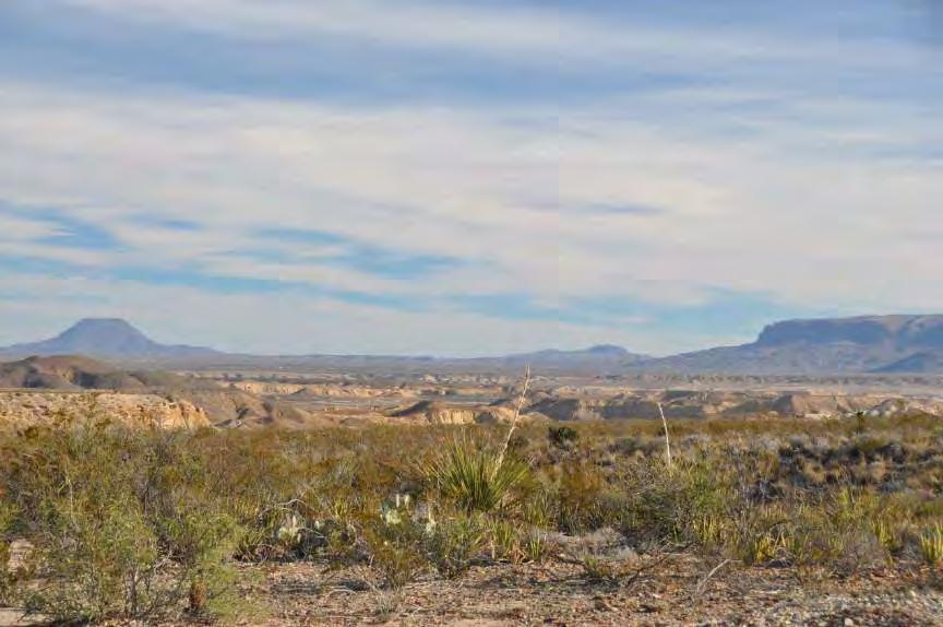
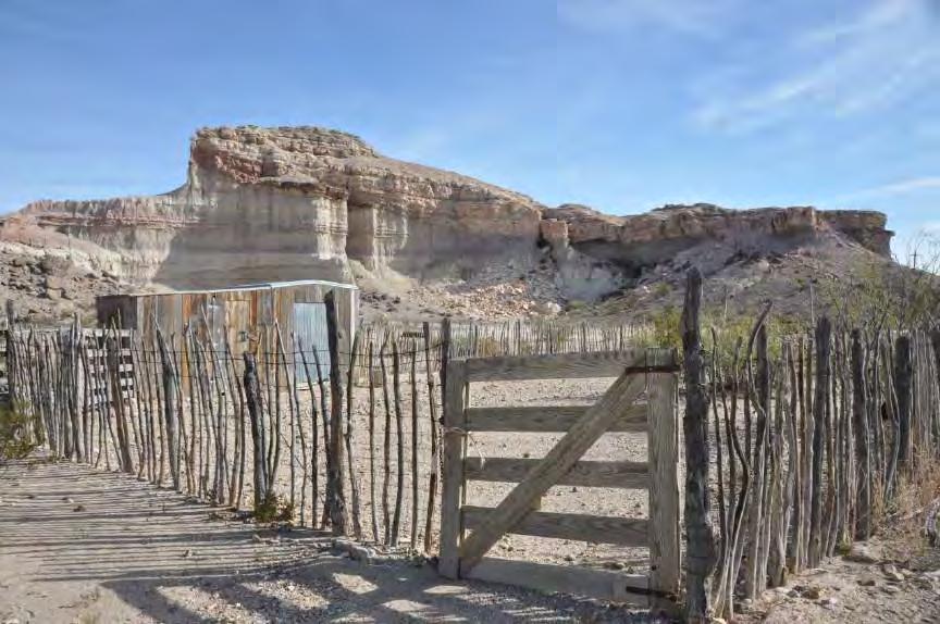
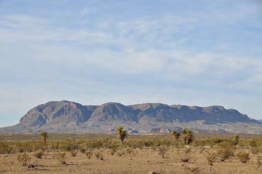
2 Agua Fria Ranch +/- 23,482 Acres Brewster County, Texas Next to Big Bend Ranch State Park James King, Agent Office Location Agua Fria Ranch is located 60 minutes south of Alpine, Texas, west of Highway 118 at the end of well-maintained gravel Agua Fria Road. As the Raven flies it's only 12 miles north of Study Butte and Terlingua at the gateway of Big Bend National Park and only 15 miles from Lajitas and its world class golf course and amazing resort amenities, including the drop off into the canyons of the Rio Grande River. This ranch is located adjacent to the 311,000 acre Big Bend Ranch, a nationally recognized wilderness park full of outdoor adventure. The "Lefthand Shutup," a canyon draining the Solitario in Big Bend Ranch, is adjacent to Agua Fria Ranch. Acreage +/- 23,482 acres in Brewster County. Description There are few places in Texas where the legends of the old west and the landscapes that crafted them still combine to create a backdrop so stunning, so authentic, and so historic that yesterday becomes today and the Wild West still calls. Names like Whistler Mesa, Agua Fria Spring, Panther Draw, Horse Tank Draw, Black Ridge, Alamo Cesario Creek, Blackrock Draw, and Soda Spring Draw are names that still describe this historic ranch. It s also all about the water and the huge natural spring at the base of Agua Fria Mountain. Once the life blood of ancient cultures, today the crystal clear cool waters are distributed into a modern water system providing yearround water throughout the ranch. Located in the Chihuahuan Desert of Texas deep in the Big Bend Region, the ranch is comprised of almost the entire Agua Fria Mountain range with adjoining mid-lower elevation grasslands and scrubland of basin range topography between the Davis Mountains to the north, the Chisos Mountains to the south east, the Bofecillos Mountains and Solitarios to the West and Rio Grande River to the south. Agua Fria Ranch is a working cattle and hunting ranch, with the historic Whistler Headquarters located adjacent to an amazing rock formation where one would expect Rooster Cogburn to come riding up out of the past to water his horse! The ranch
3 and its network of roads and 21 water troughs is impressive and provide spectacular views of area mountains, canyons, and desert floors to combine into a mix of habitats. There is a working Bentonite Mining Lease on a 320 acre parcel of fee mineral land. This ranch has been owned and operated by the same family since 1960 and this mineral operation provides good annual income. This surface mining operation is restricted into a specific area so you get ranch income with only a specific area of the ranch being impacted. Also the mine keeps the main road into the ranch off paved highway 118 in excellent working order year-round. Details on income and production can be provided to qualified buyers. Ranch will be subject to a one year lease with current mining operation so that any extension terms can be negotiated with the new owners. Habitat The landscape is diverse with high mountains to wide-open rolling desert and draws surrounded by rugged mountain ranges which can be seen from most places on the property. Classic Big Bend County of the Old West, Agua Fria Ranch has maintained much of the environment and appearance of times past. This vast area lies in wide elevation range between 3,100 and 4,441 feet allowing for mix of vegetation from the mid to lower Chihuahuan Desert such as Spanish dagger, yucca, creosote, ocotillo, and cholla with a mix of chino grama, black grama, bear grass, and sideoats grama with scattered brush. In springtime this landscape is in bloom with a wide variety of cactus, yucca, and native plants including the Big Bend Bluebonnets. Draws and Creeks on the ranch have heavier brush like mesquite, desert willow, cottonwood, white brush, and catclaw. Wildlife This property is home to many species of birds, raptors, songbirds, and game birds such as Blue (Scaled) Quail, Morning dove and White-Winged dove as well as larger mammals of the desert such as Desert Mule deer, Javelina, Aoudad, and mountain lion. The brush, forbs, and grasses provide excellent habitat for these game and nongame animals. This is Chihuahuan Desert hunting land at its best and a nature lover s dream. Water Agua Fria Spring is a prolific natural water feature located at the base of Agua Fria Mountain that is captured and distributed throughout the ranch. Water is gathered by a series of recently improved water tanks and pumps to high elevation storage and gravity piped and distributed into 21 water troughs and to the ranch improvements. This elaborate and modern water system allows for the wildlife to flourish and the cattle to distribute widely on the ranch. There are several dirt water tanks to hold summer rains.
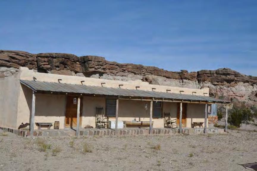
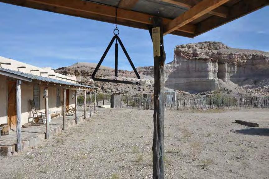
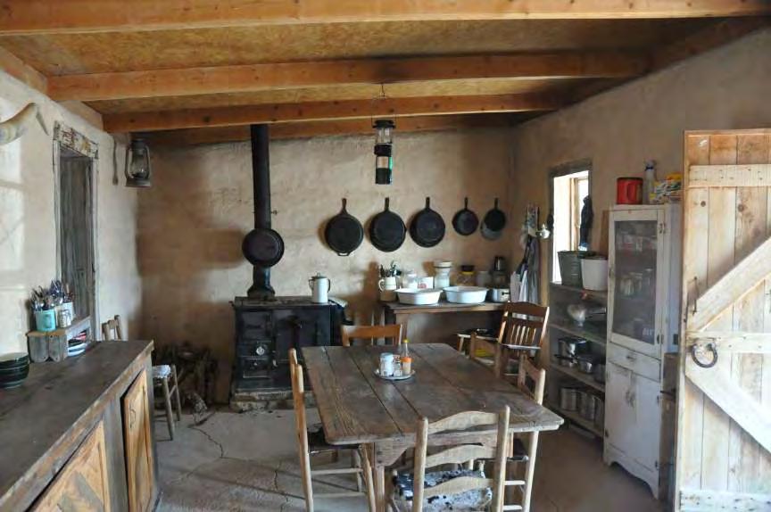
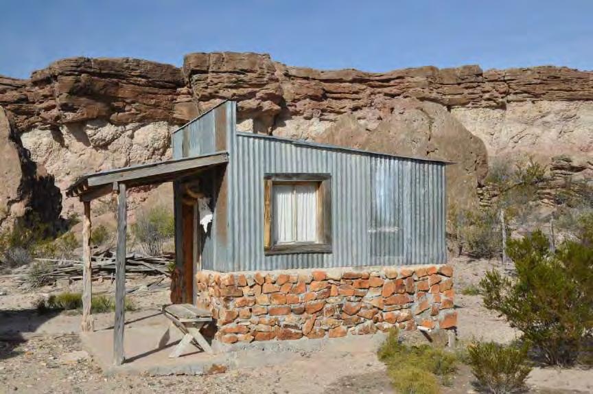
4 Improvements There are three separate areas of improvements on the ranch and one mine operation. Old Agua Fria HQ- base of Agua Fria Mountain -Site of the old Ranch Headquarter. -Spring Box and Water Storage. -Old House used as storage. -Small Shed that has the only hardline telephone on ranch. -Unfinished Adobe main house with excellent view of Spring and Mountain. White House-central part of Ranch -Adobe One Bedroom/One Bath Camp House. -Large Screen sleeping and work porch. -Kitchen with wood stove. -Propane heat. -Central Corrals and Pens Whistler Headquarters-north end of Ranch -Authentic Adobe Kitchen/Living/Dining with one Bedroom -Front Porch -Wood Stove and Propane Fridge and Heat -Separate Sleeping Bunkhouse with 2Bedrooms/2Bathrooms and Long Porch -Stand Alone Bathhouse with shower, sink, and dressing area. -Outbuildings and set of pens. -Elevated water storage. -Outdoor Fire pit with picnic tables. Price $650 per acre Minerals Seller will retain 25% Minerals owned. Contact James King, Agent King Land & Water, LLC Office Cell Disclaimer This Ranch offering is subject to prior sale, change in price, or removal from the market without notice. While the information above was provided by sources deemed reliable, it is in no way guaranteed by the broker or agent.


5 BREWSTER COUNTY, TX - AGUA FRIA RANCH 23,482 AC +/- James King PO Box State Street Fort Davis, TX Tel: (432) E l P a s o El Paso Socorro San Elizario ST 54 H u d s p e t h 20 Van Horn C u l b e r s o n 285 R e e v e s L o v i n g Pecos W i n k l e r ST W a r d ST 302 ST 18 West Odessa 20 C r a n e ST 329 E c t o r Odessa 385 KING LAND & WATER M i d l a n d ST 17 ST ST 349 U p t o n ST Lobo ST 118 Belding Fort Stockton 10 AGU A RD RD FRIA FRIA Big Bend Ranch State Park Miles ST 118 Candelaria J e f f D a v i s 90 ST 166 Quebec Ryan Ruidosa P r e s i d i o Indio Ochoa 67 Shafter Presidio Plata ST 17 Redford ST 17 Fort Davis ST 118 Marfa Nopal Casa Piedra!^ Alpine ST 118 Chancellor Marathon B r e w s t e r 385 P e c o s 285 T e r r e l l LongfellowSanderson ST 34 Dryden 90 Terlingua Lajitas Study Butte-Terlingua Date: Data Source: ESRI I Legend!^ Location Legend Boundary Big Bend National Park Miles The information contained herein was obtained from sources deemed to be reliable. Frontier GIS makes no warranties or guarantees as to the completeness or accuracy thereof
 BUNKHOUSE BATH HOUSE SHED/PENS KITCHEN & GUEST HOUSE +U AGU A FR IA RD!= +U UT UT!")
 Old Agua Fria HQ [½ Trough UT!")


6 AGUA FRIA RANCH BREWSTER COUNTY, TX - 23,482 AC +/- KING LAND & WATER A L A M O D E C E S A R I O C R E E K!) BUNKHOUSE BATH HOUSE SHED/PENS KITCHEN & GUEST HOUSE +U AGU A FR IA RD!= +U UT UT!) [½ UNFINISHED ADOBE HOUSE SHED OLD HOUSE [½ Date: Aerial Flown: 2012 Data Source: TNRIS, NHD Ê +U Main Entrance!) Old Agua Fria HQ [½ Trough UT!) Whistler HQ!= White House Spring/Seep Water Storage Tanks Agua Fria Rd Road/Trail Creek Pond/Tank Miles James King 600 North State Street PO Box 109 Fort Davis, TX Tel: (432) Property Boundary The information contained herein was obtained from sources deemed to be reliable. Frontier GIS makes no warranties or guarantees as to the completeness or accuracy thereof
 Old Agua Fria HQ [½ Trough UT!) Whistler HQ!")
7 AGUA FRIA RANCH BREWSTER COUNTY, TX - 23,482 AC +/- KING LAND & WATER O M A L A C D E A E S R C I I O R E E K!) +U AGU A FR IA RD!= +U UT UT!) [½ Date: Data Source: TNRIS, NHD +U Main Entrance!) Old Agua Fria HQ [½ Trough UT!) Whistler HQ!= White House Spring/Seep Ê Water Storage Tanks [½ Agua Fria Rd Road/Trail Creek Pond/Tank Miles James King 600 North State Street PO Box 109 Fort Davis, TX Tel: (432) Property Boundary The information contained herein was obtained from sources deemed to be reliable. Frontier GIS makes no warranties or guarantees as to the completeness or accuracy thereof

8


9

10
11
12


13

14


15
Alamito Waters Ranch 80 acres, Presidio County, Texas James King, Agent Office Cell
 Alamito Waters Ranch 80 acres, Presidio County, Texas James King, Agent Office 432-426-2024 Cell 432-386-2821 James@KingLandWater.com King Land & Water LLC P.O. Box 109, 600 State Street, Fort Davis, TX
Quebec Ranch 12,500Acres Presidio County, Texas
 Quebec Ranch 12,500Acres Presidio County, Texas James King, Agent Office 432.426.2024 Cell 432.386.2821 James@KingLandWater.com Quebec Ranch 12,500 Acres Marfa, Presidio County, Texas James King, Agent
Kennedy Ranch 3,187 Acres, near Marfa, Presidio County Texas
 Kennedy Ranch 3,187 Acres, near Marfa, Presidio Texas James King, Agent Office 432-426-2024 Cell 432-386-2821 James@KingLandWater.com King Land & Water LLC P.O. Box 109, 600 State Street, Fort Davis, TX
Quebec Ranch 12,500 acres, Presidio County
 Quebec Ranch 12,500 acres, Presidio County Quebec Ranch 12,500 Acres Marfa, Presidio County, exas James King, Agent Office 432.426.2024 James@KingLandWater.com Location he Quebec Ranch is located 25 miles
Kennedy Ranch /- acres, Presidio County, Texas
 Kennedy Ranch 3187 +/- acres, Presidio County, Texas Kennedy Ranch 3,187 Acres Casa Piedra Road Marfa, Presidio County, Texas James King, Agent Office 432 426.2024 James@KingLandWater.com Location The
South Alamito Creek Ranch
 South Alamito Creek Ranch 1500 acres, Presidio County, Texas James King, Agent Office 432-426-2024 Cell 432-386-2821 James@KingLandWater.com King Land & Water LLC P.O. Box 109, 600 State Street, Fort Davis,
Aplomado Flats Ranch acres, Brewster County, Texas
 Aplomado Flats Ranch 2701.7 acres, Brewster County, Texas James King, Agent Office 432-426-2024 Cell 432-386-2821 James@KingLandWater.com King Land & Water LLC P.O. Box 109, 600 State Street, Fort Davis,
Alamito Creek Preserve Ranches for Sale Marfa, Presidio County, Texas
 Alamito Creek Preserve Ranches for Sale Marfa, Presidio County, Texas James King, Agent Office 432 426.2024 Cell 432 386.2821 James@KingLandWater.com Alamito Creek Preserve Various size Ranch Properties,
Comanche Trail Ranch 48,404 Acres, Pecos County, Texas James King, Agent Office Cell
 Comanche rail Ranch 48,404 Acres, Pecos County, exas James King, Agent Office 432-426-2024 Cell 432-386-2821 James@KingLandWater.com King Land & Water LLC P.O. Box 109, 600 State Street, Fort Davis, X
Randolph Ranch 12,164 Acres Brewster and Pecos Counties, Texas
 Randolph Ranch 12,164 Acres Brewster and Pecos Counties, Texas James King, Agent Office 432.426.2024 Cell 432.386.2821 James@KingLandWater.com Randolph Ranch 12,164 Acres Brewster and Pecos Counties, Texas
carpenter real estate presents:
 carpenter real estate presents: this is one of the best trophy class desert mule deer, aoudad sheep and bird hunting ranches in west texas. Elevations range from 4,400 feet to 5,180 feet. Ideal habitat
Marfa House and Ranch Property 2,400 acres with premier residence, Marfa, Presidio County, Texas
 Marfa House and Ranch Property 2,400 acres with premier residence, Marfa, Presidio County, Texas James King, Agent Office 432 426.2024 Cell 432 386.2821 James@KingLandWater.com Marfa House and Ranch Property
Blue Mountain Retreat Acres, Jeff Davis County, Texas
 Blue Mountain Retreat 29.33 Acres, Jeff Davis County, Texas Blue Mountain Retreat 29.33 acres Fort Davis, Jeff Davis County, Texas James King, Agent Office 432 426.2024 James@KingLandWater.com Location
The Swan House and Adobe Construction Lab Sales Presentation Presidio, Texas Big Bend Country, reachable by scenic route only.
 The Swan House and Adobe Construction Lab Sales Presentation Presidio, Texas Big Bend Country, reachable by scenic route only. 500 Acres 2,000 sq. ft. house 360º views Adjacent to Big Bend State Park Solar
David Gold Hiking Tours
 David Gold Hiking Tours Join us for a West Texas Active Adventure Tour February 14 21, 2017 Led by David Gold and Ulrike Porat The Big Bend area of West Texas is one of the most remote, and least visited
Coyote Creek Apache County, Arizona
 Coyote Creek Apache County, Arizona Listed for sale exclusively by: Traegen Knight Headquarters West Ltd. PO BOX 1980 St. Johns, AZ 85936 Phone: (928) 524-3740, Fax: (928) 563-7004, Cell: (602) 228-3494
Cherry County, Nebraska
 Cherry County, Nebraska Co-Listed with Maddux Landbanc Realty, LLC Offered Exclusively By: NORTH PLATTE OFFICE P.O. Box 1166 I-80 & US Hwy 83 North Platte, NE 69103 www.agriaffiliates.com (308) 534-9240
Old Thomasson Range, Chico, CA
 AG-LAND INVESTMENT BROKERS 275 Sale Lane, Suite 2 / P. O. Box 896 Red Bluff, CA 96080 530.529.4400 office / 530.527.5042 fax Old Thomasson Range, Chico, CA Property: Approximately 5,270 acres bordered
Objectives. Understand the different physical & human characteristics of each region
 TEXAS REGIONS Objectives Know the 4 regions of Texas Understand the different physical & human characteristics of each region Understand how physical differences affect human characteristics (way of life)
A little helpful hint.. PLEASE TAKE CORNELL NOTES AND THEN REWRITE YOUR NOTES AT HOME. YOU WILL NEED TO ORGANIZE YOUR NOTES USING EITHER MAIN IDEAS
 JOANNE HOWARD A little helpful hint.. PLEASE TAKE CORNELL NOTES AND THEN REWRITE YOUR NOTES AT HOME. YOU WILL NEED TO ORGANIZE YOUR NOTES USING EITHER MAIN IDEAS OR QUESTIONS Can you name the Regions of
Producing Chandler Walnut Orchard
 AG-LAND Investment Brokers 275 Sale Lane Red Bluff, CA 96080 530-529-4400 Fax 530-527-5042 Producing Chandler Walnut Orchard West Sacramento Avenue - Chico, CA AG-LAND INVESTMENT BROKERS 275 Sale Lane
Natural Texas. Regions and Climates
 Natural Texas Regions and Climates Two Kinds: Physical geography Climate, vegetation, rivers, lakes, oceans, plateaus, plains, and mountain ranges Human geography Economic activities How we earn a living
V E R M E J O P A R K R A N C H
 V E R M E J O P A R K R A N C H ABOUT TED TURNER EXPEDITIONS Ted Turner Expeditions is rooted in two million acres of wild, private North American landscape acquired by Ted Turner as a pioneering investment
Name period date assigned date due date returned. Texas Ecoregions
 Name period date assigned date due date returned Directions: Go to the following website: https://www-k6.thinkcentral.com/epc/start.do Use the log in that is taped to the top of your laptop. If you are
1.0 PURPOSE AND FORMAT OF THE FINAL EIR
 1.0 PURPOSE AND FORMAT OF THE FINAL EIR 1.1 PROJECT OVERVIEW CEMEX (RMC Pacific Materials, dba CEMEX) operates the Bonny Doon Shale and Limestone Quarries in Santa Cruz County for the production of Portland
Big Bend National Park Visitor Study
 Big Bend National Park Visitor Study The Visitor Services Project 2 OMB Approval 1024-0099 Expiration Date: 08-15-92 3 DIRECTIONS One adult in your group should complete the questionnaire. It should only
Chapter 6. Field Trip to Sandia Mountains.
 University of New Mexico Biology 310L Principles of Ecology Lab Manual Page -40 Chapter 6. Field Trip to Sandia Mountains. Outline of activities: 1. Travel to Sandia Mountains 2. Collect forest community
Changes in Texas Ecoregions
 Comment On Lesson Changes in Texas Ecoregions The state of Texas can be divided into 10 distinct areas based on unique combinations of vegetation, topography, landforms, wildlife, soil, rock, climate,
Upper Owyhee Watershed Assessment
 * Owyhee Watershed Council and Scientific Ecological Services The upper Owyhee subbasin is located in parts of three states: the southeastern corner of Oregon, the southwestern corner of Idaho, and north
Name period date assigned date due date returned. Texas Ecoregions
 Name period date assigned date due date returned Directions: Go to the following website: https://www-k6.thinkcentral.com/epc/start.do Use the log in that is taped to the top of your laptop. If you are
For Creative Minds. Desert Habitat Fun Facts
 For Creative Minds The For Creative Minds educational section may be photocopied or printed from our website by the owner of this book for educational, non-commercial uses. Cross-curricular teaching activities,
Fall River Valley Irrigated Farmland
 AG-LAND Investment Brokers 275 Sale Lane Red Bluff, CA 96080 530-529-4400 Fax 530-527-5042 Fall River Valley Irrigated Farmland Tehama McArthur, County, California 2015 well, 16 inch casing, 150 HP, 2,000
POPULATION TRENDS FOR TULARE PSEUDOBAHIA AND STRIPED ADOBE LILY
 POPULATION TRENDS FOR TULARE PSEUDOBAHIA AND STRIPED ADOBE LILY Kern County has more endangered, threatened and rare plant species than most states. The geography and environmental conditions in the county
CALIFORNIA AGRICULTURAL PR OPERTIES, IN C. GALE RANCH
 CALIFORNIA AGRICULTURAL PR OPERTIES, IN C. GALE RANCH LOCATION: The Ranch is located 6 Yi miles west of the City of Davis on the northwest corner of County Roads 29A and 92E in Yolo County. SIZE: 368.64
STAAR Science Tutorial 40 TEK 8.9C: Topographic Maps & Erosional Landforms
 Name: Teacher: Pd. Date: STAAR Science Tutorial 40 TEK 8.9C: Topographic Maps & Erosional Landforms TEK 8.9C: Interpret topographic maps and satellite views to identify land and erosional features and
Arizona Recreation Map By Benchmark Maps READ ONLINE
 Arizona Recreation Map By Benchmark Maps READ ONLINE Families can come and see what the Sierra Montana Recreation Center has to offer. The center has a game room with Xbox 360s on high definition TV's,
Cripps Ranch 76+/- Acres Orchard Development Opportunity Dixon, CA. Presented By:
 Cripps Ranch 76+/- Acres Orchard Development Opportunity Dixon, CA Presented By: Cripps Ranch 76+/- Acres Orchard Development Opportunity Dixon, CA Location: This property is located at 5663 Dally Road
LANDSCAPE CHANGE IN THE SOUTHWEST: Historical changes in selected ecosystems of the southwestern United States
 LANDSCAPE CHANGE IN THE SOUTHWEST: Historical changes in selected ecosystems of the southwestern United States Robert H. Webb U.S. Geological Survey 520 N. Park Avenue Tucson, AZ 85719 rhwebb@usgs.gov
TEXAS Regions Coastal Plains North Central Plains Great Plains Mountains & Basins
 TEXAS Regions Coastal Plains North Central Plains Great Plains Mountains & Basins To help protect your privacy, PowerPoint has blocked automatic download of this picture. Coastal Plains Most populated
City of Six Project. Gold Mining Property in Downieville, CA. 60 Acres of Claims. Estimated Resource of over 8,800 ounces of Gold
 City of Six Project Gold Mining Property in Downieville, CA 60 Acres of Claims Estimated Resource of over 8,800 ounces of Gold Adjoining the famous Ruby Mine Property Located on a Rich Tertiary Channel
Sacramento River Farmland Anderson, California
 AG-LAND INVESTMENT BROKERS 275 Sale Lane / P. O. Box 896 Red Bluff, CA 96080 530.529.4400 office / 530.527.5042 fax Sacramento River Farmland Anderson, California Property: 45 +/- acres of farmland with
B. T. Brady, M. S. Bedinger, John Mikels, William H. Langer, and Deborah A. Mulvihill
 DEPARTMENT OF THE INTERIOR UNITED STATES GEOLOGICAL SURVEY TO ACCOMPANY WRI REPORT 83-4121-B MAP SHOWING GROUND-WATER LEVELS, SPRINGS. AND DEPTH TO GROUND WATER, BASIN AND RANGE PROVINCE, TEXAS by B. T.
More Sites for the LWA: South Circle
 More Sites for the LWA: South Circle John Dickel (UNM), Pat Crane (NRL), and Aaron Cohen (NRL) August 24, 2007 ABSTRACT In this memo we describe a visit to more potential sites for the LWA. We employ the
FOR SALE +/- 419 ACRES ¼ Mile South of Alliance Airport
 FOR SALE +/- 419 ACRES ¼ Mile South of Alliance Airport Alliance Airport Subject property +/- 419 AC Pat McDowell +1 817 334 8106 pat.mcdowell@am.jll.com JLL 201 Main Street, Suite 1440 Fort Worth, TX
Bluff: 7:29 am Belen: 12:25 pm Airtime: 4.9 hrs Total PIC Time: Total Logged Time:
 Sunday, October 8, 2017 Cobra flight #605, PIC #618, 4 landings San Juan Goosenecks, Monument Valley, Tall Rocks, Royal Arch, Shiprock, Chaco, Blue Hole, Mt Taylor Plateau Bluff: 7:29 am Belen: 12:25 pm
[LLAZC X.L EA0000; AZ SRP ] Notice of Temporary Closures: Selected Public Lands in La Paz County, AZ
![[LLAZC X.L EA0000; AZ SRP ] Notice of Temporary Closures: Selected Public Lands in La Paz County, AZ](/thumbs/89/100188672.jpg "[LLAZC X.L EA0000; AZ SRP ] Notice of Temporary Closures: Selected Public Lands in La Paz County, AZ") This document is scheduled to be published in the Federal Register on 12/29/2017 and available online at https://federalregister.gov/d/2017-28217, and on FDsys.gov 4310-32 DEPARTMENT OF THE INTERIOR Bureau
This document is scheduled to be published in the Federal Register on 12/29/2017 and available online at https://federalregister.gov/d/2017-28217, and on FDsys.gov 4310-32 DEPARTMENT OF THE INTERIOR Bureau
FOR LEASE ±1,800 SF OUTPARCEL NEW CONSTRUCTION, SINGLE TENANT
 FOR LEASE ±1,800 SF OUTPARCEL NEW CONSTRUCTION, SINGLE TENANT DEERFIELD BEACH FL 33441 ROXANNE REGISTER Vice President of Leasing & Sales RoxanneRegister@dkatz.com (561) 869-4346 HIGHLIGHTS Retail only
Urbanczyk CV, page 1
 Kevin Urbanczyk Professor, Department of Biology, Geology, and Physical Sciences Director, Rio Grande Research Center Sul Ross State University 400 N. Harrison, Alpine, TX 79832 432-837-8110 kevinu@sulross.edu
!! The Rio Grande River starts at the Rocky Mountains in Colorado. This River is 1,885 miles long!
 The Southwest Region By Taylor Noble and Kaiya Leismer Land and water The southwest region covers a lot of land but the Southwest region has lowest amount of states in any other region. In the Southwest
Hydrologic Briefing Tropical Storm Harvey
 Hydrologic Briefing Tropical Storm Harvey 10:30 AM CDT Sunday, August 27, 2017 Prepared by: John Metz NWSCorpus www.weather.gov/corpuschristi Situation Overview Tropical Storm Harvey Harvey to remain a
Information Paper. Kansas City District. Missouri River Fish and Wildlife Mitigation Project Jim and Olivia Hare Wildlife Area, MO
 City District Information Paper River Fish and Wildlife Mitigation Project Jim and Olivia Hare Wildlife Area, MO Riverine habitat created in 2004/2005 by modifying existing river structures along the banks,
For Sale on Bids. Open House By Appointment
 For Sale on Bids Written Bid Deadline: Friday, September 7, by 12:00 P.M. Noon 52+/- Acres & Storage Facility Grand Forks, ND Property Location: Conveniently located off Interstate 29 and North Washington
Chittenden Road Prune Orchard Corning, California
 AG-LAND INVESTMENT BROKERS 275 Sale Lane / P. O. Box 896 Red Bluff, CA 96080 530.529.4400 office / 530.527.5042 fax Chittenden Road Prune Orchard Corning, California Property: 40.00 acres planted to producing
Kiwanis International
 Page 1 of 7 Southwest 02 Division 2 K0003A Albuquerque NM 86 87 1.16 +1 K04781 Aztec NM 4 4 0.00 K14177 Bloomfield NM 4 4 0.00 K08906 Coronado, Albuquerque NM 11 11 0.00 K17384 Corrales NM 39 40 2.56 +1
TRACT 7: ±252 Acres Irrigated Farmland Grassland
 TRACT 7: ±252 Acres Irrigated Farmland Grassland 1880 FM 2013, Friona, Texas 79035 ±252 acres of irrigated farmland and grassland. This farmland is currently being leased and farmed. The lease agreement
Historic Cultural Properties Inventory (HCPI) Base Form (FORM 1)
 Base Form (FORM 1)") Historic Cultural Properties Inventory (HCPI) Base Form (FORM 1) Historic Preservation Division, New Mexico Office of Cultural Affairs For HPD Office use only: HCPI No. District No. NRHP: SRCP: Criteria:
Historic Cultural Properties Inventory (HCPI) Base Form (FORM 1) Historic Preservation Division, New Mexico Office of Cultural Affairs For HPD Office use only: HCPI No. District No. NRHP: SRCP: Criteria:
Colorado Front Range Wildfires Situation Report #7 Monday, July 02, :15 AM (MDT)
") Colorado Front Range Wildfires Situation Report #7 Monday, July 02, 2012 10:15 AM (MDT) Mandatory evacuations for the Waldo Canyon fire have been reduced from 35,000 to 3,000. Remaining evacuations are
Colorado Front Range Wildfires Situation Report #7 Monday, July 02, 2012 10:15 AM (MDT) Mandatory evacuations for the Waldo Canyon fire have been reduced from 35,000 to 3,000. Remaining evacuations are
CALIFORNIA AGRICULTURAL PR OPERTIES, IN C. BOWLSBEY 320 LIBERTY ISLAND ROAD BUYER: RASSMUSSEN TRUST
 CALIFORNIA AGRICULTURAL PR OPERTIES, IN C. BOWLSBEY 320 LIBERTY ISLAND ROAD SELLER: BOWLSBEY TRUST BUYER: RASSMUSSEN TRUST LOCATION: The Bowlsbey 320 is located ten (10) miles southeast of the City of
For personal use only
 Quarterly Activities Report Quarter Ending 30 September 2018 (ASX Code: HE8) (Helios or Company) is pleased to report its activities for the quarter ended 30 September 2018. Oil Discovery in the Ojinaga
CANYON THE. The Grand Canyon A Reading A Z Level K Leveled Book Word Count: 394 H K N. LEVELED BOOK K Grand
 The Grand Canyon A Reading A Z Level K Leveled Book Word Count: 394 Connections Writing and Art What would you like to do at the Grand Canyon? Why? Draw a picture and write five or more sentences about
Belen: 7:56 am Mid-Valley: 10:09 am Mid-Valley: 10:14 am Belen: 11:34 am Airtime: 3.5 hrs Total PIC Time: Total Logged Time: 1565.
 Tuesday, May 2, 2017 Cobra flight #582, PIC #595, 3 landings Amber Hills, Caldron of Hell, Valley of the Horses, Caldron, Puerco Elk, Belen, Rio Grande, Mid-Valley, Manzano Mountain Ridge Run Belen: 7:56
±2.14 AC Broad River Road Irmo, South Carolina. Site. Property Features. Lee Bussell, Jr
 Ballentine Family YMCA Pizza Hut For Sale ±2.14 AC School District 5 Office Brakes-4-Less 10737 Broad River Road Irmo, South Carolina Lee Bussell, Jr. +1 803 744 9865 lbussell@naiavant.com Property Features
A Correlation of. Pearson Interactive Science Content Leveled Readers Grade 4
 A Correlation of Pearson Content Leveled Readers To Scott Foresman Reading Street Texas, 2011 to Scott Foresman Reading Street Texas,, 2011 This document was created as a service to Texas teachers to show
MAPS AND THEIR CLASSIFICATION
 MAPPING MAPS AND THEIR CLASSIFICATION WHAT IS A MAP? A map is representation of the Earth's surface, showing how things are related to each other by distance, direction, and size. Maps are a way of showing
[LLAZC03000.L EA0000 LVRCA13SA A, AZ SRP Notice of Temporary Closures of Public Lands in La Paz County, AZ
 This document is scheduled to be published in the Federal Register on 01/15/2013 and available online at http://federalregister.gov/a/2013-00542, and on FDsys.gov 4310-32-P DEPARTMENT OF THE INTERIOR Bureau
BENBROOK ECONOMIC DEVELOPMENT CORPORATION COME GROW WITH US.
 BENBROOK ECONOMIC DEVELOPMENT CORPORATION COME GROW WITH US www.benbrook-tx.gov Introduction: Who Are We Video included 04 Benbrook Demographics Click for larger image of aerial 05 Retail Opportunites
Written by Vowery Dodd Carlile and Traci Burnett Illustrated by Karen Birchak
 Written by Vowery Dodd Carlile and Traci Burnett Illustrated by Karen Birchak Table of Contents INTRODUCTION...5 TO THE TEACHER...6 STORIES ABOUT TEXAS: Background, Vocabulary Activities, Discussion Questions,
SHADE/SHADOW REPORT. For the Proposed 8777 Washington Project. Culver City, CA. Prepared for:
 SHADE/SHADOW REPORT For the Proposed 8777 Washington Project Culver City, CA Prepared for: VITRUVIAN CULVER CITY LLC (THE APPLICANT) 5822 WEST WASHINGTON BOULEVARD CULVER CITY, CALIFORNIA 90232 Prepared
Tertiary System. Eocene Series BUCK HILL GROUP. Pruett Formation
 42 Tertiary System Eocene Series BUCK HILL GROUP Pruett Formation Name and type section--goldich and Elms (949) named the Pruett from exposures near the Pruett Ranch in the north-central part of the Buck
"WHERE RIVERS MEET: The Yukon-Charley Rivers National Preserve"
 'RQQD0DWUD]]R 7KH:ULWLQJ:RUNV 1:6DXYLH,VODQG5G 3RUWODQG25 PDWUD]]R#PVQFRP North Shore Productions The National Park Service "WHERE RIVERS MEET: The Yukon-Charley Rivers National Preserve" Final Script
BUILDING AN ASSET MANAGEMENT GEODATABASE FOR RANCHING. Matt Crawford, GISP
 BUILDING AN ASSET MANAGEMENT GEODATABASE FOR RANCHING Matt Crawford, GISP Introduction East Foundation Formed in 2007 Mission Research Education Outreach Properties Six ranches ~ 215,000 acres San Antonio
[ 1.2 ] Texas Geography
![[ 1.2 ] Texas Geography](/thumbs/78/78091378.jpg "[ 1.2 ] Texas Geography") [ 1.2 ] Texas Geography [ 1.2 ] Texas Geography Learning Objectives Identify how geography helps people understand and organize information about a place. Compare the physical and human characteristics
[ 1.2 ] Texas Geography [ 1.2 ] Texas Geography Learning Objectives Identify how geography helps people understand and organize information about a place. Compare the physical and human characteristics
If searching for a ebook The Roads of Texas in pdf form, in that case you come on to right site. We present full option of this ebook in PDF, DjVu,
 The Roads Of Texas If searching for a ebook The Roads of Texas in pdf form, in that case you come on to right site. We present full option of this ebook in PDF, DjVu, epub, txt, doc forms. You may reading
UNDERSTANDING GEOLOGIC M APS
 Name: Lab Section: work in groups, but each person turns in his/her own GEOSCIENCE 001 L AB UNDERSTANDING GEOLOGIC M APS Geologic maps are colorful and even beautiful, but they also contain an amazing
Weathering and Soil Formation. Chapter 10
 Weathering and Soil Formation Chapter 10 Old and New Mountains The Appalachian Mountains appear very different from the Sierra Mountains. The Appalachians are smaller, rounded, gently sloping, and covered
Module 10: Resources and Virginia Geology Topic 4 Content: Virginia Geology Notes
 Virginia is composed of a very diverse landscape that extends from the beaches and barrier islands all of the way to the highly elevated Appalachian Plateau. Geologists have discovered ancient shallow
Laboratory Exercise #3 The Hydrologic Cycle and Running Water Processes
 Laboratory Exercise #3 The Hydrologic Cycle and Running Water Processes page - 1 Section A - The Hydrologic Cycle Figure 1 illustrates the hydrologic cycle which quantifies how water is cycled throughout
CRABWOOD FARMHOUSE NR WINCHESTER SO22
 CRABWOOD FARMHOUSE NR WINCHESTER SO22 CRABWOOD FARMHOUSE OFF SARUM RD WINCHESTER Grade II listed farmhouse close to Winchester with glorious views Sitting room Dining room Study Kitchen/breakfast room
Deschutes County Property Information
 Deschutes County Property Information Report Date: 1/25/2015 3:11:23 PM Disclaimer The information and maps presented in this report are provided for your convenience. Every reasonable effort has been
Weathering/ Erosion/ Deposition in the Texas Ecoregions
 Practice Test Study these answers Weathering/ Erosion/ Deposition in the Texas Ecoregions 1. In the Texas Panhandle, physical weathering by abrasion is usually caused by wind, water and gravity 2. Two
Big Chino Valley Pumped Storage Project (FERC No ) Vegetation Mapping and Habitat Assessment Study Plan
 Vegetation Mapping and Habitat Assessment Study Plan") March 21, 2018 1.0 Introduction Big Chino Valley Pumped Storage LLC (BCV), a subsidiary of ITC Holdings Corp. (ITC), submitted a preliminary permit application to the Federal Energy Regulatory Commission
March 21, 2018 1.0 Introduction Big Chino Valley Pumped Storage LLC (BCV), a subsidiary of ITC Holdings Corp. (ITC), submitted a preliminary permit application to the Federal Energy Regulatory Commission
1300 FRANK SINATRA DRIVE
 HUDSON COUNTY HOBOKEN NJ 1300 FRANK SINATRA DRIVE SPACE DETAILS LOCATION Northwest between 13th and 14th Streets GROUND FLOOR SPACE Ground Floor 7,096 SF FRONTAGE 66 FT on Frank Sinatra Drive CEILING HEIGHT
In this lab, we will study and analyze geologic maps from a few regions, including the Grand Canyon, western Wyoming, and coastal California.
 Name: Lab Section: work in groups, but each person turns in his/her own GEOSCIENCE 001 LAB UNDERSTANDING GEOLOGIC MAPS Geologic maps are colorful and even beautiful, but they also contain an amazing amount
MONITORING THE EFFECTS OF CLIMATE CHANGE ON SPRINGS, SEEPS AND OTHER WATER NATIONAL PRESERVE
 MONITORING THE EFFECTS OF CLIMATE CHANGE ON SPRINGS, SEEPS AND OTHER WATER RESOURCES IN THE MOJAVE NATIONAL PRESERVE Boris Poff and Debra Hughson Mojave National Preserve, California CLIMATE CHANGE Predictions
Storm Report: January 27, 2008 Maricopa County, AZ
 Storm Report: January 27, 2008 Maricopa County, AZ Engineering Division, Flood Warning Branch TABLE OF CONTENTS Meteorology...2 Precipitation...4 Runoff...9 ALERT System Alarms...12 TABLES Table 1 Summary
Table of Contents. Introduction...3 How to Use This Book...4 Standards Information...6 The World in Spatial Terms
 Table of Contents Introduction...................................................................3 How to Use This Book..........................................................4 Standards Information...........................................................6
Advanced Geologic Exploration, Inc.
 Advanced Geologic Exploration, Inc. Scientists of the Earth PO Box 1956, Chester, CA 96020 Voice: (530) 258-4228 Fax (530) 258-4339 www.advancedgeologic.com January 23, 2009 Job No. G-081201 Terri Barber,
Following the Civil War, many Americans and Europeans continued to move into the WEST
 1860-1900 Following the Civil War, many Americans and Europeans continued to move into the WEST as far as the eye can see millions of acres of treeless grassland. Between the Mississippi River and the
Lab Topographic Maps. Name: Partner: Purpose. Background Information
 Lab Topographic Maps Name: Partner: Purpose The purpose of this lab is to familiarize you with graphic representations of the Earth s surface primarily maps. Simple line maps show the spatial relationship
Changes in Texas Ecoregions Copy the questions and answers
 Changes in Texas Ecoregions Copy the questions and answers 1. What are some kinds of damage that hurricanes cause? Roads and bridges might be washed away. Trees and power lines can be knocked down. Area
Wessinger Road, Hilton Area Chapin, South Carolina
 779' For Sale 191' 182' 171'! A! B 858' 4.84 ± Acres 788' 4.25 ± Acres 60' 241' 321' Wessinger Road, Hilton Area Chapin, South Carolina 357' 115' 51' 294'! C! D 6.51 ± Acres 902' 8.35 ± Acres 246' 60'
Review of Riparian Function Riparian Management Riparian Monitoring
 Review of Riparian Function Riparian Management Riparian Monitoring Water Shed Water Catchment Water catching creek Water shedding creek Properly functioning riparian area Properly Functioning Riparian
conceptdesigns C0NCEPTDESIGNSARCHITETURE.CO.NZ architecture S t a g e Gisborne Beach House
 C0NCEPTDESIGNSARCHITETURE.CO.NZ conceptdesigns architecture S t a g e 2 A Gisborne Beach House GISBORNE BEACH BRIEF HOUSE conceptdesigns architecture Beth and Chris want to design and build their forever
APPENDIX 1 LITTLE EGYPT FROM THE AIR
 APPENDIX 1 LITTLE EGYPT FROM THE AIR FIGURE 1. In this 1930 City of Dallas aerial photo, the land surrounding Little Egypt is seen as cultivated fields and agricultural structures. The Hill property is
Passwords. Social Studies Vocabulary. Texas: Grade 7
 Passwords Social Studies Vocabulary Texas: Grade 7 To the Student What is federalism? How are independence and interdependence different? What does an anthropologist do? Passwords: Social Studies Vocabulary
3.3 CLIMATE, GEOLOGY, TOPOGRAPHY, AND SOILS CLIMATE GEOLOGY TOPOGRAPHY
 3.3 CLIMATE, GEOLOGY, TOPOGRAPHY, AND SOILS This section describes the climate, geology, topography, and soil resource characteristics of the Yolo Bypass Wildlife Area (Wildlife Area). Agricultural soil
Dawn, Menagerie Springs, Big Bend National Park.
 Dawn, Menagerie Springs, Big Bend National Park. I first visited Big Bend NP for a couple of days in 1998. I returned 15 years later in May 2013 to catch bats with a team from Angelo State University.
2013 Esri International User Conference July 8 12, 2013 San Diego, California. Unleashing the POWER of GIS at Questa Mine
 2013 Esri International User Conference July 8 12, 2013 San Diego, California Unleashing the POWER of GIS at Questa Mine July 11th, 2013 Jeff Schoenbacher, Senior Environmental Engineer Chevron Mining,
ENGINEERING EVALUATION OF THE STANLEY MINE ADVENTURE PARK AREA CLEAR CREEK COUNTY, COLORADO. Prepared for:
 braun Braun Consulting Engineers ENGINEERING EVALUATION OF THE STANLEY MINE ADVENTURE PARK AREA CLEAR CREEK COUNTY, COLORADO Prepared for: STANLEY MINES ADENTURE PARK 3375 W. POWERS CIRCLE LITTLETON, COLORADO
Arizona Game and Fish Department s Wildlife Water Catchments Project on the Tonto National Forest
 Arizona Game and Fish Department s Wildlife Water s Project on the Tonto National Forest This project is a cooperative effort between the Tonto National Forest and Arizona Game and Fish Department. The