LANDSCAPE CHANGE IN THE SOUTHWEST: Historical changes in selected ecosystems of the southwestern United States
|
|
|
- Frank Underwood
- 6 years ago
- Views:
Transcription
1 LANDSCAPE CHANGE IN THE SOUTHWEST: Historical changes in selected ecosystems of the southwestern United States Robert H. Webb U.S. Geological Survey 520 N. Park Avenue Tucson, AZ Raymond M. Turner Retired, U.S. Geological Survey
 2,096 on major rivers 910 in Utah 544 in California and Nevada Desert")
2 Mojave Desert Scrub Saguaros Riparian Vegetation THE DESERT LABORATORY REPEAT PHOTO COLLECTION Four collections, a total of 5,925 matches 3,058 in Arizona (1,524 in Grand Canyon) 2,096 on major rivers 910 in Utah 544 in California and Nevada Desert Grassland
3 WHY HAVE SOUTHWESTERN LANDSCAPES CHANGED HISTORICALLY? Climate variability, particularly persistent dry and wet periods, have recurred historically (and prehistorically). Land-use practices, particularly livestock grazing, have had considerable landscape effects. The interaction of plant life-history strategies and these effects drives biological (and some geomorphic) changes. Some geomorphic changes drive biological changes.


4 SOUTHERN ARIZONA HISTORIC CLIMATIC VARIABILITY EARLY 20 TH CENTURY DROUGHT EARLY 20 TH CENTURY WET PERIOD MID-CENTURY DROUGHT LATE 20 TH CENTURY WET PERIOD EARLY 21 ST CENTURY DROUGHT
5 INFORMATION ON HISTORICAL CHANGE IN RIPARIAN VEGETATION Observations of riparian vegetation begins with the Spanish explorations of Historical observations become more numerous with the scientific explorations beginning in the 1840s. Photography of begins in Mapped vegetation begins around Aerial photography begins in Satellite-platform remote sensing begins in 1974.


6 STUDY University of Arizona Press, 2007 AREA
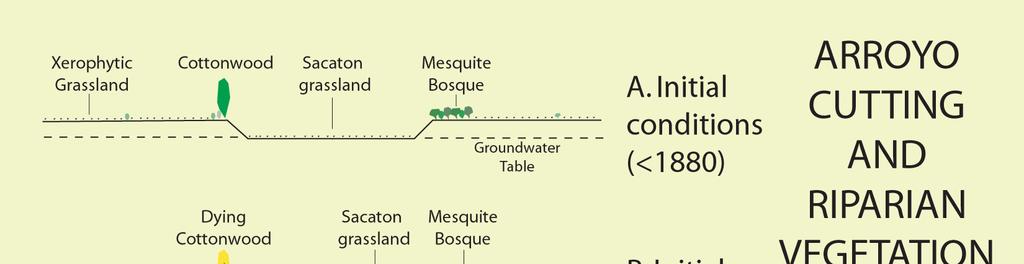
7 REACHES THAT LOST RIPARIAN VEGETATION This area was extensively grazed historically. Santa Cruz River at Martinez Hill (1912)

8 Santa Cruz River at Martinez Hill (1981)

9 Santa Cruz River at Martinez Hill (2002)


10 SANTA CRUZ RIVER AT TUCSON
11 REACHES THAT GAINED RIPARIAN VEGETATION San Pedro River, 1890 Livestock grazing was heavy at this time, but note abundant perennial grasses

12 San Pedro River, 1962 Livestock grazing was heavy at this time before establishment of the San Pedro Riparian National Conservation Area

13 San Pedro River, 1994 Livestock have been removed from this reach


14 SAN PEDRO RIVER AT PALOMINAS

15 LANDSAT CHANGE DETECTION: San Pedro River (Kepner et al., 1999)

16 GILA RIVER AT CALVA (1935). The channel is wide from repeated floods in the 1930s. Open cottonwood galleries appear at left and center; willow is in right foreground.
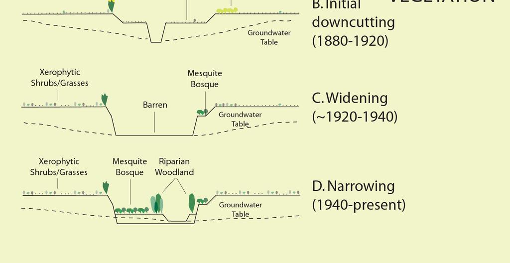
17 GILA RIVER AT CALVA (1964). At the start of the Gila Phreatophyte Project, the reach was clogged with tamarisk, a non-native species.

18 GILA RIVER AT CALVA (1973). An herbicide was applied and mechanical treatments used to kill and remove tamarisk. Meanwhile, the channel is narrowing.

19 GILA RIVER AT CALVA (1984). By the 1980s, despite repeated flooding, tamarisk had begun to regrow in quantities in this reach.
20 GILA RIVER AT CALVA (2000). Tamarisk has regained at least its 1964 quantities in front of this camera station. No native species are visible, although mesquite is to the right.

21 Tamarisk Mesquite Cottonwoods
22 CHANGE IN RIPARIAN VEGETATION Large Reservoirs losses
23 WHY HAVE DECREASES OCCURRED? (How to Kill Riparian Trees Without Chainsaws) Excessively pump ground water: if ground-water use lowers water tables 10 m depth or more, most native riparian vegetation dies. Drop ground-water levels too quickly for roots to follow. Divert most or all surface water and pump ground water excessively. Provide no flood control, install bank protection, and and pump ground water excessively. Build a dam and impound a reservoir.
24 WHY HAVE INCREASES OCCURRED? Two wet episodes characterize 20 th century climate: the early 20 th century wet period (~ ) and the late 20 th century wet period ( ). Both periods had increased winter rainfall and floods beneficial to woody riparian vegetation. Temperatures (particularly winter and nighttime) have increased in the region since the 1960s, leading to a longer growth period, particularly for riparian vegetation.
25 ARROYOS AND FLOODS Modern arroyos downcut between about 1880 and 1909 in most of the Southwest at a time of high livestock grazing. Other Holocene arroyos formed about AD and before AD when no livestock were on the landscape. Most geomorphologists attribute arroyo downcutting to the occurrence of large floods associated with increases in regional climatic variability, not livestock presence Livestock and other land use (e.g., roads) undoubtedly increased erosion locally during historical downcutting


26 NET EFFECT OF ARROYOS Kanab Creek (1871) Kanab Creek (2000)


27 Escalante River near Escalante, Utah 1932 This area was 1985 extensively grazed historically This area was heavily grazed at the time of this photograph.
28

29 CHANGES IN THE SONORAN DESERT Repeat photography documents large increases in mesquite and other woody C3 vegetation in what formerly was C4 grasslands. The changes represent an increase of as much as 5 to 10 times the above-ground biomass on upland sites. University of Arizona Press, 2003


30 Woody Plants in Desert Grassland 1901 Fire frequency ~ 5-10 years, grazing moderate-heavy 1995 Fires suppressed, grazing levels unchanged?


31 1887 Earthquake Fault, Sonora, Mexico 2000
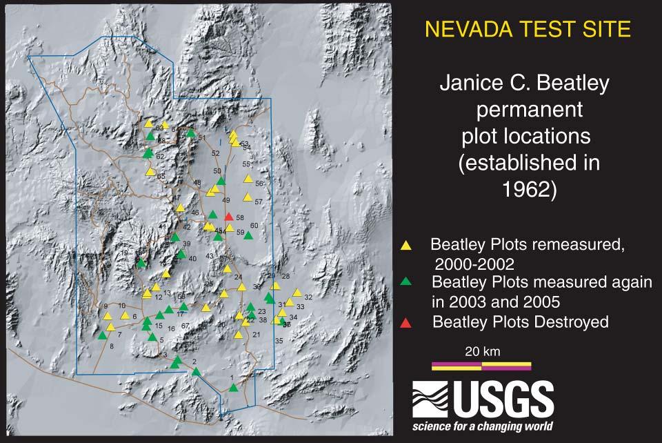
.")
. Mexico")
32 Mesquite Increase in Desert Grassland (1890). Santa Cruz River just north of Mexico (1996). Santa Cruz River just north of Mexico

33 (1903). Coyote Mountain

34 (1999). Coyote Mountain


35 Grazing was heavy until 1958, when it was 1935 eliminated 1960 CHANGES IN THE SONORAN DESERT

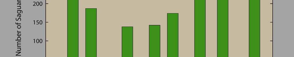
36 But Drought is Killing Paloverdes (saguaro nurse plants), In permanent plots in Arizona and Sonora, saguaros are increasing in some and decreasing in others There is no clear relation between livestock grazing and saguaro demography Saguaro establishment requires nurse plants and favorable climatic conditions; grazing, drought, and severe freezes can reduce populations directly or influence nurse plants


37 MacDougal Pass, Sonora 1907 Grazing increased, eliminates big galleta grass, saguaros increase (n=255)
38 Saguaro Demographics In 9 permanent plots in Arizona and Sonora, saguaros are increasing in some and decreasing in others There is no clear relation between livestock grazing and saguaro demography Saguaro establishment requires nurse plants and favorable climatic conditions; grazing, drought, and severe freezes can reduce populations directly or influence nurse plants
39 Biomass Change SPECIES 1ST PHOTO MEDIAN 2ND PHOTO MEDIAN 3RD PHOTO MEDIAN % CHANGE 1ST- 2ND Bursage Chihuahuan whitethorn Cardón Creosotebush Foothill paloverde Jumping cholla Mesquite Oaks Ocotillo ND- 3RD One-seed juniper Pricklypear Saguaro

40 VEGETATION CHANGES IN THE MOJAVE DESERT Dr. Janice C. Beatley established 68 permanent vegetation plots on the Nevada Test Site in 1962 Perennial vegetation was measured in 1963, 1975, and (all), 2003, 2005 (partial) USGS, 2003
41


42 PLOT 3, ROCK VALLEY, MOJAVE DESERT
. From 2000-2005, Ambrosia decreased in cover by -35% (2000-2004 drought).")
43 42 YEARS OF CHANGE IN PLOT 3 From , the total number of shrubs on Plot 3 increased by 24%. Larrea increased in height and cover by 43% and 168%. Ambrosia increased in in height and cover by 17% and 166%. Grayia decreased in cover by -80% ( drought). From , Ambrosia decreased in cover by -35% ( drought). Larrea remained about the same. Total cover changed +38% and -23% from and , respectively.
44 42 YEARS OF CHANGE IN COVER (ALL UNDISTURBED PLOTS) Creosote Sagebrush, pinyonjuniper Chenopods
.")
45 Plot 50 (1964) This area may never have been grazed (no nearby water sources). This assemblages is a chenopod shrubland.

46 Plot 50 (2001) This assemblages is now dominated by perennial grasses.
47 PERENNIAL GRASSES ON THE NEVADA TEST SITE Perennial species (Achnatherum speciosum and A. hymenoides) had massive pulse establishment in the early 1980s (start of late 20 th century wet period). The drought of caused widespread mortality of perennial grasses established less than 10 years earlier. Wet periods ( , ) caused significant reestablishment. The early 21 st century drought caused mortality again. No grazing occurs here these dynamics in perennial grass populations is climatically driven.
48 SUMMARY Landscapes (and ecosystems) should be expected to change. Sometimes landscapes (and ecosystems) change for reasons other than land use. Heavy livestock grazing causes significant ecosystem damages. However, the mere presence of livestock does not drive change on most landscapes. Climate never has been constant. Climate variability should be expected.
49 WHY ARE CERTAIN SPECIES OF WOODY PLANTS INCREASING IN BIOMASS? Increased growing season (increased winter temperatures), combined with increased winter precipitation, is the most plausible reason. Increased carbon dioxide could be a factor favoring C3 versus C4 plants. However, photosynthetic pathway does not fully explain the response of many species. For riparian vegetation, flow regulation gives and takes away hydrologic stability versus recruitment potential. Sustained drought could reverse these gains; drought combined with ground-water pumping could increase amount of riparian mortality.
It is relatively simple to comprehend the characteristics and effects of an individual id fire. However, it is much more difficult to do the same for
 Interactive Effects of Plant Invasions and Fire in the Hot Deserts of North America Matt Brooks U.S. Geological Survey Western Ecological Research Center Yosemite Field Station, El Portal CA Presentation
Desert Biomes of North America and Beyond
 Desert Biomes of North America and Beyond Optional reading: McAuliffe 1994, Landscape Evolution, Soil Formation, and Ecological Patterns and Processes in Sonoran Desert Bajadas (review figures) 10/21/09
Big Chino Valley Pumped Storage Project (FERC No ) Vegetation Mapping and Habitat Assessment Study Plan
 Vegetation Mapping and Habitat Assessment Study Plan") March 21, 2018 1.0 Introduction Big Chino Valley Pumped Storage LLC (BCV), a subsidiary of ITC Holdings Corp. (ITC), submitted a preliminary permit application to the Federal Energy Regulatory Commission
March 21, 2018 1.0 Introduction Big Chino Valley Pumped Storage LLC (BCV), a subsidiary of ITC Holdings Corp. (ITC), submitted a preliminary permit application to the Federal Energy Regulatory Commission
REMOTE SENSING ACTIVITIES. Caiti Steele
 REMOTE SENSING ACTIVITIES Caiti Steele REMOTE SENSING ACTIVITIES Remote sensing of biomass: Field Validation of Biomass Retrieved from Landsat for Rangeland Assessment and Monitoring (Browning et al.,
Climate: long term average weather. Use climograph to display climate data. Climograph
 March 27, 2014: Introduction to climate. If you have not yet taken Exam 1 or Exam 2, please email me to set up a time to take a makeup. All makeup exams should be completed before taking Exam 3. Climate:
MONITORING THE EFFECTS OF CLIMATE CHANGE ON SPRINGS, SEEPS AND OTHER WATER NATIONAL PRESERVE
 MONITORING THE EFFECTS OF CLIMATE CHANGE ON SPRINGS, SEEPS AND OTHER WATER RESOURCES IN THE MOJAVE NATIONAL PRESERVE Boris Poff and Debra Hughson Mojave National Preserve, California CLIMATE CHANGE Predictions
2011 National Seasonal Assessment Workshop for the Eastern, Southern, & Southwest Geographic Areas
 2011 National Seasonal Assessment Workshop for the Eastern, Southern, & Southwest Geographic Areas On January 11-13, 2011, wildland fire, weather, and climate met virtually for the ninth annual National
Seasonal and interannual relations between precipitation, soil moisture and vegetation in the North American monsoon region
 Seasonal and interannual relations between precipitation, soil moisture and vegetation in the North American monsoon region Luis A. Mendez-Barroso 1, Enrique R. Vivoni 1, Christopher J. Watts 2 and Julio
Coyote Creek Apache County, Arizona
 Coyote Creek Apache County, Arizona Listed for sale exclusively by: Traegen Knight Headquarters West Ltd. PO BOX 1980 St. Johns, AZ 85936 Phone: (928) 524-3740, Fax: (928) 563-7004, Cell: (602) 228-3494
SAGUARO AND AGAVE SURVEY: PROPOSED SANTA RITA ROAD WATERLINE FOR THE ROSEMONT PROJECT TABLE OF CONTENTS LIST OF FIGURES
 SAGUARO AND AGAVE SURVEY: PROPOSED SANTA RITA ROAD WATERLINE FOR THE ROSEMONT PROJECT PREPARED FOR: PREPARED BY: Rosemont Copper Company WestLand Resources, Inc. DATE: February 3, 2010 PROJECT NO. 1049.14
Case Study: Ecological Integrity of Grasslands in the Apache Highlands Ecoregion
 Standard 9: Screen all target/biodiversity element occurrences for viability or ecological integrity. Case Study: Ecological Integrity of Grasslands in the Apache Highlands Ecoregion Summarized from: Marshall,
Upper Owyhee Watershed Assessment
 * Owyhee Watershed Council and Scientific Ecological Services The upper Owyhee subbasin is located in parts of three states: the southeastern corner of Oregon, the southwestern corner of Idaho, and north
Lecture 24 Plant Ecology
 Lecture 24 Plant Ecology Understanding the spatial pattern of plant diversity Ecology: interaction of organisms with their physical environment and with one another 1 Such interactions occur on multiple
Improvement of the National Hydrography Dataset for Parts of the Lower Colorado Region and Additional Areas of Importance to the DLCC
 Improvement of the National Hydrography Dataset for Parts of the Lower Colorado Region and Additional Areas of Importance to the DLCC Carlos Reyes-Andrade California State University, Northridge September
3.3 CLIMATE, GEOLOGY, TOPOGRAPHY, AND SOILS CLIMATE GEOLOGY TOPOGRAPHY
 3.3 CLIMATE, GEOLOGY, TOPOGRAPHY, AND SOILS This section describes the climate, geology, topography, and soil resource characteristics of the Yolo Bypass Wildlife Area (Wildlife Area). Agricultural soil
DISCUSSION PURPOSES ONLY C A L I F O R N I A S T A T E L A N D S C O M M I S S I O N
 C A L I F O R N I A S T A T E L A N D S C O M M I S S I O N SAN JOAQUIN RIVER REACH 2B OVERVIEW OF THE CALIFORNIA STATE LANDS COMMISSION ADMINISTRATIVE MAPS PRESENTATION Water Boundary Principles Best
Crystal Moncada. California State University San Bernardino. January- July Brett R. Goforth- Department of Geography and Environmental Studies
 A Geographical Information System (GIS) Based Evaluation of Landslide Susceptibility Mapped on the Harrison Mountain Quadrangle of the Santa Ana River Watershed Crystal Moncada California State University
VEGETATION EVA BOEHRINGER
 VEGETATION EVA BOEHRINGER April 2, 2014 WUP CONSULTATIVE COMMITTEE WUP Consultative Committee (WUP CC) recognized that riparian and wetland vegetation in the reservoir drawdown zone is valuable for fish,
Alamito Creek Preserve Ranches for Sale Marfa, Presidio County, Texas
 Alamito Creek Preserve Ranches for Sale Marfa, Presidio County, Texas James King, Agent Office 432 426.2024 Cell 432 386.2821 James@KingLandWater.com Alamito Creek Preserve Various size Ranch Properties,
Earth s Major Terrerstrial Biomes. *Wetlands (found all over Earth)
") Biomes Biome: the major types of terrestrial ecosystems determined primarily by climate 2 main factors: Depends on ; proximity to ocean; and air and ocean circulation patterns Similar traits of plants
Biomes Biome: the major types of terrestrial ecosystems determined primarily by climate 2 main factors: Depends on ; proximity to ocean; and air and ocean circulation patterns Similar traits of plants
Outline. Precipitation. How would you describe precipitation patterns in your area? Bottom line: one-page summary
 Outline Precipitation June 13, 2013 Phoenix, AZ Measuring rainfall Patterns of precipitation in time and space Predicting precipitation Patterns related to extreme events (floods & drought) Paleo-climate
Biomes There are 2 types: Terrestrial Biomes (on land) Aquatic Biomes (in the water)
 Aquatic Biomes (in the water)") Biomes There are 2 types: Terrestrial Biomes (on land) Aquatic Biomes (in the water) Terrestrial Biomes Grassland, Desert, and Tundra Biomes: Savanna Temperate grassland Chaparral Desert Tundra Chapter
Biomes There are 2 types: Terrestrial Biomes (on land) Aquatic Biomes (in the water) Terrestrial Biomes Grassland, Desert, and Tundra Biomes: Savanna Temperate grassland Chaparral Desert Tundra Chapter
Carmel River Bank Stabilization at Rancho San Carlos Road Project Description and Work Plan March 2018
 Carmel River Bank Stabilization at Rancho San Carlos Road Project Description and Work Plan March 2018 EXISTING CONDITION The proposed Carmel River Bank Stabilization at Rancho San Carlos Road Project
Changes in Texas Ecoregions Copy the questions and answers
 Changes in Texas Ecoregions Copy the questions and answers 1. What are some kinds of damage that hurricanes cause? Roads and bridges might be washed away. Trees and power lines can be knocked down. Area
Historical channel change on the Upper Gila River, Arizona and New Mexico in response to anthropogenic modifications and extreme floods
 Historical channel change on the Upper Gila River, Arizona and New Mexico in response to anthropogenic modifications and extreme floods www.archives.gov www.paztcn.wr.usgs.gov wrh.noaa.gov Upper Gila River
Ecological Succession
 Ecological Succession 1 Ecological Succession is The observed process of change in the species structure of an ecological community over time. The community begins with relatively few pioneering plants
Which map shows the stream drainage pattern that most likely formed on the surface of this volcano? A) B)
 B)") 1. When snow cover on the land melts, the water will most likely become surface runoff if the land surface is A) frozen B) porous C) grass covered D) unconsolidated gravel Base your answers to questions
1. When snow cover on the land melts, the water will most likely become surface runoff if the land surface is A) frozen B) porous C) grass covered D) unconsolidated gravel Base your answers to questions
Pages 63 Monday May 01, 2017
 Pages 6 Notebook check: Biome basics and A Modern Desert Biome Warm up: Copy the graph below, title it Defining factor a biome: temperature and precipitation Pages 6 an based on regarding Learning scale:
Southwest Drought Webinar. Becky Bolinger, Assistant State Climatologist Colorado Climate Center June 25, 2018
 Southwest Drought Webinar Becky Bolinger, Assistant State Climatologist Colorado Climate Center June 25, 2018 COLORADO CLIMATE CENTER Current Drought U.S. Drought Monitor Drought evolution COLORADO CLIMATE
The Protection of Ecosystem Services in the US- Mexico Border
 The Protection of Ecosystem Services in the US- Mexico Border Lina Ojeda-Revah El Colegio de la Frontera Norte Christopher Brown New Mexico State University ACES 2010 Annual Meeting Gila River Indian Community
Chapter 6. Field Trip to Sandia Mountains.
 University of New Mexico Biology 310L Principles of Ecology Lab Manual Page -40 Chapter 6. Field Trip to Sandia Mountains. Outline of activities: 1. Travel to Sandia Mountains 2. Collect forest community
Chapter 2 Planet Earth
 Chapter 2 Planet Earth Section Notes Earth and the Sun s Energy Water on Earth The Land Close-up The Water Cycle World Almanac Major Eruptions in the Ring of Fire Quick Facts Chapter 2 Visual Summary Video
TEXAS WILDLAND FIRE POTENTIAL WINTER/SPRING 2018/2019
 TEXAS WILDLAND FIRE POTENTIAL WINTER/SPRING 2018/2019 Texas A&M Forest Service Predictive Services Prepared December 12 th 2018 Brad Smith Luke Kanclerz Scott Breit Tom Spencer Mike Dunivan 2 Fire Potential
Developing Monitoring Protocols for Vegetation Response to Watershed Restoration
 Developing Monitoring Protocols for Vegetation Response to Watershed Restoration Natalie R. Wilson* 1, Laura M. Norman 1, Miguel Villarreal 1, Steve Buckley 2, Joel Sankey 3, David Dean 3, Steve Delong
Local Climate Change Impacts for Central Illinois
 Local Climate Change Impacts for Central Illinois Molly Woloszyn Extension Climatologist Midwestern Regional Climate Center & Illinois-Indiana Sea Grant Urbana Sustainability Advisory Commission February
Lesson 9: California Ecosystem and Geography
 California Education Standards: Kindergarten, Earth Sciences 3. Earth is composed of land air, and water. As a basis for understanding this concept: b. Students know changes in weather occur from day to
The ecology of sahuaro: Linking population ecology to conservation and management
 The ecology of sahuaro: Linking population ecology to conservation and management Alberto Búrquez and Enriquena Bustamante Departamento de Ecología de la Biodiversidad Instituto de Ecología Universidad
South Alamito Creek Ranch
 South Alamito Creek Ranch 1500 acres, Presidio County, Texas James King, Agent Office 432-426-2024 Cell 432-386-2821 James@KingLandWater.com King Land & Water LLC P.O. Box 109, 600 State Street, Fort Davis,
Extreme Weather. Extreme weather has always been a part of Utah
 Climate Notes Extreme Weather Extreme weather has always been a part of Utah Floods Severe storms Wind 1920 Lehi hail storm killed birds and chickens 1971 Farmington wind storm Climate vs. Weather Climate:
National Wildland Significant Fire Potential Outlook
 National Wildland Significant Fire Potential Outlook National Interagency Fire Center Predictive Services Issued: September, 2007 Wildland Fire Outlook September through December 2007 Significant fire
CESPL-RG-A March 12, 2008 REGULATORY DIVISION MEMORANDUM. SUBJECT: Traditional Navigable Waters, Navigable In-Fact Determination for the Gila River
 CESPL-RG-A March 12, 2008 REGULATORY DIVISION MEMORANDUM SUBJECT: Traditional Navigable Waters, Navigable In-Fact Determination for the Gila River 1. To provide documentation to determine the status of
Preliminaries to Erosion: Weathering and Mass Wasting
 Preliminaries to Erosion: Weathering & Mass Wasting All things deteriorate in time. Virgil 1 Preliminaries to Erosion: Weathering and Mass Wasting Denudation The Impact of Weathering and Mass Wasting on
The Long-Term History of Oak Woodlands in California Scott Mensing University of Nevada, Reno
 The Long-Term History of Oak Woodlands in California Scott Mensing University of Nevada, Reno Miocene ~20 5 MYA Ancestors of modern oaks present in western U.S. Pliocene ~5 2 MYA By end, oaks restricted
National Wildland Significant Fire Potential Outlook
 National Wildland Significant Fire Potential Outlook National Interagency Fire Center Predictive Services Issued: April 1, 2008 Next Issue: May 1, 2008 Wildland Fire Outlook April 2008 through July 2008
Presentation Overview. Southwestern Climate: Past, present and future. Global Energy Balance. What is climate?
 Southwestern Climate: Past, present and future Mike Crimmins Climate Science Extension Specialist Dept. of Soil, Water, & Env. Science & Arizona Cooperative Extension The University of Arizona Presentation
Arizona Climate Summary May 2018 Summary of conditions for April 2018
 April 2018 Temperature and Precipitation Summary Arizona Climate Summary May 2018 Summary of conditions for April 2018 April 1 st 16 th : April was a very dry month across Arizona. Several low pressure
Debris flow: categories, characteristics, hazard assessment, mitigation measures. Hariklia D. SKILODIMOU, George D. BATHRELLOS
 Debris flow: categories, characteristics, hazard assessment, mitigation measures Hariklia D. SKILODIMOU, George D. BATHRELLOS Natural hazards: physical phenomena, active in geological time capable of producing
Soft stems. Wind pollinated
 Plant Adaptations The temperature in grassland or the prairies are windy, have hot summers and cold winters. Rainfall is uncertain and in the range of about 25-27 cm per year, and drought is common. The
Changes in Texas Ecoregions
 Comment On Lesson Changes in Texas Ecoregions The state of Texas can be divided into 10 distinct areas based on unique combinations of vegetation, topography, landforms, wildlife, soil, rock, climate,
Arizona Climate Summary February 2012
 Arizona Climate Summary February 2012 Summary of conditions for January 2012 January 2012 Temperature and Precipitation Summary January 1 st 20 th : The New Year has started on a very dry note. The La
Appendix J Vegetation Change Analysis Methodology
 Appendix J Vegetation Change Analysis Methodology Regional Groundwater Storage and Recovery Project Draft EIR Appendix-J April 2013 APPENDIX J- LAKE MERCED VEGETATION CHANGE ANALYSIS METHODOLOGY Building
Science EOG Review: Landforms
 Mathematician Science EOG Review: Landforms Vocabulary Definition Term canyon deep, large, V- shaped valley formed by a river over millions of years of erosion; sometimes called gorges (example: Linville
Biome- complex of terrestrial communities that cover a large area; characterized by soil, climate, plants, and animals Plants and animals vary by
 Major Land Biomes Biome- complex of terrestrial communities that cover a large area; characterized by soil, climate, plants, and animals Plants and animals vary by tolerance to temperature and precipitation
Tracking Phenology in Tucson as an Indicator of a Changing Climate. LoriAnne Barnett Education Coordinator, USA-NPN
 Tracking Phenology in Tucson as an Indicator of a Changing Climate LoriAnne Barnett Education Coordinator, USA-NPN Tracking Phenology Overview Phenology and Climate Nature s Notebook and the USA National
2. PHYSICAL SETTING FINAL GROUNDWATER MANAGEMENT PLAN. 2.1 Topography. 2.2 Climate
 FINAL GROUNDWATER MANAGEMENT PLAN 2. PHYSICAL SETTING Lassen County is a topographically diverse area at the confluence of the Cascade Range, Modoc Plateau, Sierra Nevada and Basin and Range geologic provinces.
Flooding. April 21, Notes 4/20 CONGRATULATIONS!!!!! Activity 2: AZ State Museum due TODAY. Extra Credit 2: Returned at end of class
 April 21, 2011 Flooding 1927 Mississippi Flood Notes 4/20 Activity 2: AZ State Museum due TODAY Extra Credit 2: Returned at end of class CONGRATULATIONS!!!!! Andrew Richard Undergraduate Research Grant
Ecosystems Chapter 4. What is an Ecosystem? Section 4-1
 Ecosystems Chapter 4 What is an Ecosystem? Section 4-1 Ecosystems Key Idea: An ecosystem includes a community of organisms and their physical environment. A community is a group of various species that
BEC Correlation BGxh2 01, 02, 05, 06. Site Characteristics
 Description This type is dominated by bluebunch wheatgrass, Sandberg s bluegrass, and sagebrush with low cover of mixed forbs and moderate cover of biological crusts. Production and total plant cover is
Chapter 52 An Introduction to Ecology and the Biosphere
 Chapter 52 An Introduction to Ecology and the Biosphere Ecology The study of the interactions between organisms and their environment. Ecology Integrates all areas of biological research and informs environmental
COLUSA BASIN WATERSHED ASSESSMENT. Final. Prepared by: H. T. Harvey & Associates. In Collaboration With:
 COLUSA BASIN WATERSHED ASSESSMENT Prepared by: In Collaboration With: G. Mathias Kondolf Geomorph Blankinship & Associates Prepared for: Colusa County Resource Conservation District 100 Sunrise Boulevard,
Chapter 7 Part III: Biomes
 Chapter 7 Part III: Biomes Biomes Biome: the major types of terrestrial ecosystems determined primarily by climate 2 main factors: Temperature and precipitation Depends on latitude or altitude; proximity
Physical Geography: Patterns, Processes, and Interactions, Grade 11, University/College Expectations
 Geographic Foundations: Space and Systems SSV.01 explain major theories of the origin and internal structure of the earth; Page 1 SSV.02 demonstrate an understanding of the principal features of the earth
Climate Change Scenario Planning: A Tool for Managing Resources in an Era of Uncertainty
 Climate Change Scenario Planning: A Tool for Managing Resources in an Era of Uncertainty Leigh Welling Climate Change Coordinator National Park Service Natural Resource Stewardship & Science Mount Rainier
Hillslope Erosion Rates in the Oak Savannas of the Southwestern Borderlands Region
 Hillslope Erosion Rates in the Oak Savannas of the Southwestern Borderlands Region Item type Authors Publisher Journal Rights text; Proceedings Kauffman, Arron T.; Stropki, Cody L.; Ffolliott, Peter F.;
The Effect of Weather, Erosion, and Deposition in Texas Ecoregions
 The Effect of Weather, Erosion, and Deposition in Texas Ecoregions 7.8B: I can analyze the effects of weathering, erosion, and deposition on the environment in ecoregions of Texas Weathering The breakdown
Review of Riparian Function Riparian Management Riparian Monitoring
 Review of Riparian Function Riparian Management Riparian Monitoring Water Shed Water Catchment Water catching creek Water shedding creek Properly functioning riparian area Properly Functioning Riparian
Elevation (ft) Slope ( ) County CONDITION CATEGORY. Parameter Natural Condition Slightly impacted Moderately Impacted Heavily Impacted
 Slope ( ) County CONDITION CATEGORY. Parameter Natural Condition Slightly impacted Moderately Impacted Heavily Impacted") Version: 8/25/14 Meadow Name Date : / / MM DD YYYY GPS Location:. N. W GPS Datum (e.g., WGS 84, NAD 27) Elevation (ft) Slope ( ) County Watershed (HUC8) Landowner USGS Quad Name Observers: 7.5 or 15 (circle
Version: 8/25/14 Meadow Name Date : / / MM DD YYYY GPS Location:. N. W GPS Datum (e.g., WGS 84, NAD 27) Elevation (ft) Slope ( ) County Watershed (HUC8) Landowner USGS Quad Name Observers: 7.5 or 15 (circle
3/3/2013. The hydro cycle water returns from the sea. All "toilet to tap." Introduction to Environmental Geology, 5e
 Introduction to Environmental Geology, 5e Running Water: summary in haiku form Edward A. Keller Chapter 9 Rivers and Flooding Lecture Presentation prepared by X. Mara Chen, Salisbury University The hydro
BIOMES AND ECOSYSTEMS
 BIOMES AND ECOSYSTEMS What is a biome? A biome is a group of land ecosystems with similar climates and organisms There are 6 major land biomes and 2 major water ecosystems? LAND (6): RAINFORESTS, DESERTS,
Desert Plant Adaptations
 Desert Plant Adaptations California Deserts Limiting Factors Water Cold Winter Temperatures Cold Winter Temperatures Are Common In The Mojave Desert The Joshua Tree is the indicator species of the Mojave
DEVELOPMENT OF A LARGE-SCALE HYDROLOGIC PREDICTION SYSTEM
 JP3.18 DEVELOPMENT OF A LARGE-SCALE HYDROLOGIC PREDICTION SYSTEM Ji Chen and John Roads University of California, San Diego, California ABSTRACT The Scripps ECPC (Experimental Climate Prediction Center)
Drought and Future Water for Southern New Mexico
 Drought and Future Water for Southern New Mexico David S. Gutzler University of New Mexico gutzler@unm.edu * The big drought of 2018 * Longer term challenges for water supply * Forecasting streamflow Elephant
Upper Colorado River Basin Flows and Paleohydrology Jenny Ta
 Upper Colorado River Basin Flows and Paleohydrology Jenny Ta Introduction The Colorado River flows from its headwaters in the Rocky Mountains, through seven U.S. and two Mexican states into the Colorado
Ganbat.B, Agro meteorology Section
 NATIONAL AGENCY FOR METEOROLOGY, HYDROLOGY AND ENVIRONMENT MONITORING OF MONGOLIA Ganbat.B, Agro meteorology Section OF INSTITUTE OF METEOROLOGY AND HYDROLOGY 2009 YEAR Location Climate Northern Asia,
Topography of the conterminous United States
 Topography of the conterminous United States Potential Natural Vegetation Geology Coastal Ranges physiographic province Cascade-Sierra Mountains Cascades Mount Hood California central valley Sierra-Nevada
The 21 st Century Colorado River Hot Drought and Implications for the Future
 Coauthor: Jonathan Overpeck The 21 st Century Colorado River Hot Drought and Implications for the Future CRWCD State of the River May 4, 2017 Brad Udall Colorado State University Bradley.udall@colostate.edu
Purple Loosestrife Project Biocontrol Sites:
 Purple Loosestrife Project Biocontrol Sites: Interim results of a cooperative project between Michigan State University and Michigan Sea Grant Extension Photos, Maps and Layout by Jason K. Potter 2002
Each basin is surrounded & defined by a drainage divide (high point from which water flows away) Channel initiation
 Channel initiation") DRAINAGE BASINS A drainage basin or watershed is defined from a downstream point, working upstream, to include all of the hillslope & channel areas which drain to that point Each basin is surrounded &
DRAINAGE BASINS A drainage basin or watershed is defined from a downstream point, working upstream, to include all of the hillslope & channel areas which drain to that point Each basin is surrounded &
Sand Transport Paths in the Mojave Desert
 Sand Transport Paths in the Mojave Desert Lack of Monitoring Stations, Soil Analyses, and the Outdated Rule 403.2 Put Communities and the Environment at Risk Lucerne Valley MAC July 20, 2017 Pat Flanagan
Desert INTRODUCTION. Very few of the world's deserts are barren, windswept sand dunes. Only 30% of the Sahara is sand dunes like the ones shown here.
 Desert INTRODUCTION Scientists define a desert as a region that receives less than 25 centimeters (10 inches) of rain per year. About onethird of Earth s land surface is desert. Deserts may be hot or cold,
Description DESCRIPTION
 DESCRIPTION The location of the Upper James Watershed is located in northeastern South Dakota as well as southeastern North Dakota. It includes the following counties located in North Dakota Barnes, Dickey,
TUNDRA. Column 1 biome name Column 2 biome description Column 3 examples of plant adaptations
 Biome Cards (pp. 1 of 7) Cut out each biome card and divide each card into three sections. Place all sections in a plastic storage bag. Have one bag for every two students. Column 1 biome name Column 2
Activity 2.2: Recognizing Change (Observation vs. Inference)
") Activity 2.2: Recognizing Change (Observation vs. Inference) Teacher Notes: Evidence for Climate Change PowerPoint Slide 1 Slide 2 Introduction Image 1 (Namib Desert, Namibia) The sun is on the horizon
Activity 2.2: Recognizing Change (Observation vs. Inference) Teacher Notes: Evidence for Climate Change PowerPoint Slide 1 Slide 2 Introduction Image 1 (Namib Desert, Namibia) The sun is on the horizon
Eagle Creek Post Fire Erosion Hazard Analysis Using the WEPP Model. John Rogers & Lauren McKinney
 Eagle Creek Post Fire Erosion Hazard Analysis Using the WEPP Model John Rogers & Lauren McKinney Columbia River Gorge at Risk: Using LiDAR and GIS-based predictive modeling for regional-scale erosion susceptibility
Texas Wildland Fire Season Outlook. for. Winter 2009
 Texas Wildland Fire Season Outlook for Winter 2009 December 5, 2008 Contents Section Page Executive Summary 1 Introduction 2 Underlying Fuels Condition 4 Weather Outlook 8 Findings 10 Credits 11 Attachments
Global Patterns Gaston, K.J Nature 405. Benefit Diversity. Threats to Biodiversity
 Biodiversity Definitions the variability among living organisms from all sources, including, 'inter alia', terrestrial, marine, and other aquatic ecosystems, and the ecological complexes of which they
Arizona Climate Summary October 2018 Summary of conditions for September 2018
 Arizona Climate Summary October 2018 Summary of conditions for September 2018 September 2018 Temperature and Precipitation Summary September 1 st 17 th : The wet pattern from August continued into September
BIOMES. Definition of a Biome. Terrestrial referring to land. Climatically controlled sets of ecosystems. Characterized by distinct vegetation
 BIOMES An Introduction to the Biomes of the World Definition of a Biome Terrestrial referring to land Climatically controlled sets of ecosystems Characterized by distinct vegetation 1 In a Biome There
Chapter 8. Biogeographic Processes. Upon completion of this chapter the student will be able to:
 Chapter 8 Biogeographic Processes Chapter Objectives Upon completion of this chapter the student will be able to: 1. Define the terms ecosystem, habitat, ecological niche, and community. 2. Outline how
NIDIS Drought and Water Assessment
 NIDIS Drought and Water Assessment PRECIPITATION The images above use daily precipitation statistics from NWS COOP, CoCoRaHS, and CoAgMet stations. From top to bottom, and left to right: most recent 7-days
Severe Weather Watches, Advisories & Warnings
 Severe Weather Watches, Advisories & Warnings Tornado Watch Issued by the Storm Prediction Center when conditions are favorable for the development of severe thunderstorms and tornadoes over a larger-scale
How Do Human Impacts and Geomorphological Responses Vary with Spatial Scale in the Streams and Rivers of the Illinois Basin?
 How Do Human Impacts and Geomorphological Responses Vary with Spatial Scale in the Streams and Rivers of the Illinois Basin? Bruce Rhoads Department of Geography University of Illinois at Urbana-Champaign
How does the physical environment influence communities and ecosystems? Hoodoos in Cappadocia, Turkey
 Biomes of the World How does the physical environment influence communities and ecosystems? Hoodoos in Cappadocia, Turkey ecosystems are shaped by: abiotic factors climate/weather space Rainfall Soil air
Chapter 3. Description of the Study Area. Karl Taboga, James Stafford and Paul Taucher 3-19
 Chapter 3 Description of the Study Area Karl Taboga, James Stafford and Paul Taucher 3-19 T his study examines groundwater resources that underlie the Bear River drainage basin in Wyoming as well as areas
Beyond the Book. FOCUS Book
 FOCUS Book Suppose your city wants to build a new housing development on a steep slope outside town. Design a model to test whether the land is safe from the types of landslides you read about in this
Arizona Climate Summary February 2018 Summary of conditions for January 2018
 Arizona Climate Summary February 2018 Summary of conditions for January 2018 January 2018 Temperature and Precipitation Summary January 1 st 19 th : The new year began with a ridge of high pressure over
Review. Community and Ecosystem Ecology 4/20/11. by Dr. W.
 Review Community and Ecosystem Ecology by Dr. W. A population is the set of all members of one species in a defined area. A community is the set of all populations in a defined area. An ecosystem includes
Fluvial Driven Alluvial Fans
 Fluvial Driven Alluvial Fans Restoration Project Evaluations - Examples from the Russian and Napa River Watersheds Mia Docto Masters Thesis UC Berkeley 1. Basic Fan Description 2. Fluvial Driven Fan Characteristics
NIDIS Weekly Climate, Water and Drought Assessment Summary. Upper Colorado River Basin July 31, 2012
 NIDIS Weekly Climate, Water and Drought Assessment Summary Upper Colorado River Basin July 31, 2012 Fig. 1: July month-to-date precipitation in inches. Fig. 2: SNOTEL WYTD precipitation percentiles (50%
Climate Change in Colorado: Recent Trends, Future Projections and Impacts An Update to the Executive Summary of the 2014 Report
 Climate Change in Colorado: Recent Trends, Future Projections and Impacts An Update to the Executive Summary of the 2014 Report Jeff Lukas, Western Water Assessment, University of Colorado Boulder - Lukas@colorado.edu