Tertiary System. Eocene Series BUCK HILL GROUP. Pruett Formation
|
|
|
- Elvin McCoy
- 6 years ago
- Views:
Transcription
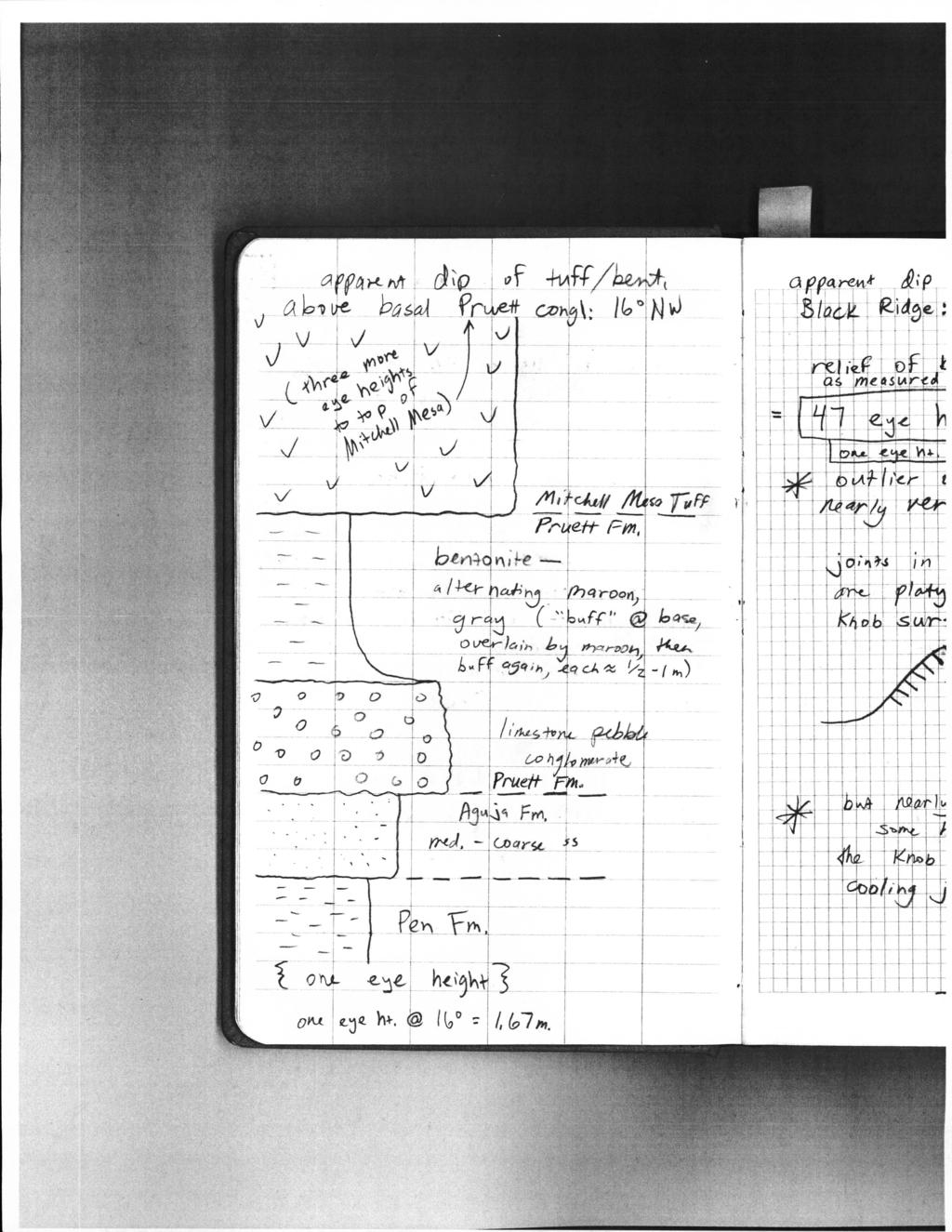
1 42 Tertiary System Eocene Series BUCK HILL GROUP Pruett Formation Name and type section--goldich and Elms (949) named the Pruett from exposures near the Pruett Ranch in the north-central part of the Buck Hill Quadrangle. There the Pruett consists,mostly of tuff, but "includes conglomerate, tuffaceous sandstone and breccia, and tuffaceous freshwater limestone," and intercalated trachyte, basalt and andesite flows. In the Buck Hill Quadrangle, the Pruett unconformably overlies the Boquillas and in some places the Pen, and is m ( ft) thick. Distribution, thickness, and lithology--the Pruett is exposed only in the extreme northern part of the quadrangle, as small outliers on downthrown sides of faults. It lies unconformably on the Pen Formation, and with the Pen forms a slope beneath the Mitchell Mesa Tuff and/or diabase sills. In the Yellow Hill Quadrangle, the Pruett consists of a basal limestone-pebble and cobble conglomerate, overlain by calclithite sandstone with minor amounts of interbedded gray and maroon tuff and bentonite. One maroon bentonite bed in the Pruett north of Hill 3964 (NC) contains white chalky limestone nodules. The thickness of the Pruett was not measured because the section is incomplete, and outcrops are small and isolated. Many outcrops consist only of basal conglomerate and the sandstone immediately above, but some include sandstone, tuff, and bentonite up to the overlying Mesa Tuff. Less than one kilometer north of the quadrangle, km east of Mesquite Tank in the Agua Fria Quadrangle, a thin secof Pruett capped by Mitchell Mesa is exposed in a cliff above the Pen Formation. The estimated thickness of the Pruett there is 9 m.- and ~ includes about 3 m of basal conglomerate. The estimated thickness of ~. the Pruett in the Yellow Hill Quadrangle is 0 to 40 m; this variation in thickness may have been produced by recent -g o-ftt V\ v..l4'\ ~ av--e- --foa $ Vt-tt..l / by ~ set.+r't>vi Ol- i. 5' M~~ N ~I aj;td Jrl 6 t fa Gfv tr of rv Z. ~ J'4!4_ >u. rel ~ 7 iu o~ fruet.f- In c/4dt'ry {,, 7 m c;f bt.5c/f G-OYl_j/omerate., /O~f#t (No-+e. l>o S- m of' Ajc.<jt4 ft't:)
2
3 ERRATA: Geology of Yellow Hill Quadrangle, Brewster County, Texas (McCulloh, 977) TEXT [not a comprehensive list of text issues, rather mostly those I saw fit to mark on my hard copy]: page correction Xl insert "ILLUSTRATIONS" above "Frontispiece" insert a second sentence in the first paragraph under Climate and Vegetation: "Most of the following section was written based on a close following of ( ) the Vegetation section of Maxwell (968), and (2) the guide to wildflowers written by Warnock (970), during the course of the field work." change "limonite strain" to read "limonite stain" [5th line from bottom] change "about 3-5 m" to read "about 305 m" [line ] change "subaerial" to read "subaqueous" [line 3] change numerous instances in the STRUCTURAL GEOLOGY chapter of trend(s)/trending to the appropriate and correct term strike(s)lstriking, e.g., on p. 09 change "trends N 20 W" to read "strikes N 20 W" [line 3 under "Clas tic Dike"] change "Structural History" to read "Cenozoic Structural History" [section heading] insert bibliographic entry for Maxwell ( 968) insert bibliographic entry for Warnock ( 970) PLATE I MAP [locations formatted by 2.5' quadrangle subdivisions; additional comments and queries marked on the file YellowHillGeol_AddCorrectComment.tif]: NW: The bend from overall N-S to E-W strike shown by the Ksp outcrop near the quadrangle boundary south of Hill 440 appears extreme, and probably does not "V" as dramatically as the "kink" shown on the map (which in fact is not fitted to the Lefthand Shutup thalweg); and the area where Tch is mapped southwest of Hill 403 and southeast of Hill 4242 has more knobs than shown, plus a small isolated Kho slump feature or remnant directly north of the largest knob depicted. NE: The Qal contacts with Tid and Kho on the east side/bank of Terlingua Creek, along its southernmost reach in the quadrangle near the eastern quadrangle boundary, lie farther east than shown. C: The fault depicted in Qal south of Hill 3473 (and south of the western end of "Airstrip") should be dotted. EC: Two apparent Tid plugs north of Saltgrass Draw and southeast of Hill 3252 (mapped from air photos after the completion of field work?) are probably just diabase gravel in surface terrace material. SW: A small Khu outlier at the southeastern corner of a fault block west-southwest of Hill 387 was not mapped; the Kdr distributions mapped may include some alluvial/terrace material; and the axis of the Terlingua-Solitario anticline depicted in the southwestern corner should be dashed, as its location and orientation were not known to me with certainty. SC: The plunging syncline that includes Hill 3735 is mapped as Khu, but some Kho also is present near its southern end; the Kdr distributions mapped may include some
4 alluvial/terrace material; and the northern of two closely spaced NE-striking faults near the southwestern end of the A-A' line of section is not valid. SE: A small Tid polygon southeast of Hill 3590 was not mapped; and the label is missing from a small fault-bounded Kp polygon northwest of Hill PLATE I CROSS SECTIONS [additional comments and queries marked on the file Yell ow HillGeol_Add CorrectComment.tif]: A-A': The base of Kgr is missing at the southwestern end of one fault block. The third and fourth faults on the line also should be remapped; the third fault (see SC, above), which the section shows as the main fault of the two, is not valid, and the fourth fault shown should be the main and only fault. B-B': The Kp label for the surface unit in the fault block directly southwest of the trap-door dome near the eastern quadrangle boundary is missing a lead line. C-C': The southwestern portion depicts hypothetical subsurface faults possibly formed in association with the uplift of the Solitario dome. The southwesternmost of these faults is shown as displacing the rim sill, which may conflict with the ages given in the text (p. 98): the dome uplift is inferred to have been Middle Eocene, whereas the rim sill age is given as 36.6 ±.6 Ma (Middle to Late Eocene). [This may reflect an episode of trance state during drafting.] References: Maxwell, R. A., 968, The Big Bend of the Rio Grande: A guide to the rocks, landscape, geologic history, and settlers of the area of Big Bend National Park: Guidebook 7, University of Texas Bureau of Economic Geology, 38 p. Warnock, B. H., 970, Wildflowers of the Big Bend country, Texas: Sul Ross State University, Alpine, Texas, 57 p. 2
5 ERRATA: Geology of Yellow Hill Quadrangle, Brewster County, Texas (McCulloh, 977) TEXT [not a comprehensive list of text issues, rather mostly those I saw fit to mark on my hard copy]: page correction Xl insert "ILLUSTRATIONS" above "Frontispiece" insert a second sentence in the first paragraph under Climate and Vegetation: "Most of the following section was written based on a close following of ( ) the Vegetation section of Maxwell ( 968), and (2) the guide to wildflowers written by Warnock (970), during the course of the field work." change "limonite strain" to read "limonite stain" [5th line from bottom] change "about 3-5 m" to read "about 305 m" [line ] change "subaerial" to read "subaqueous" [line 3] change numerous instances in the STRUCTURAL GEOLOGY chapter of trend( s )/trending to the appropriate and correct term strike( s )/striking, e.g., on p. 09 change "trends N 20 W" to read "strikes N 20 W" [line 3 under "Clas tic Dike"] change "Structural History" to read "Cenozoic Structural History" [section heading] insert bibliographic entry for Maxwell ( 968) insert bibliographic entry for Warnock ( 970) PLATE I MAP [locations formatted by 2.5' quadrangle subdivisions; additional comments and queries marked on the file YellowHillGeol_AddCorrectComment.tif]: NW: The bend from overall N-S to E-W strike shown by the Ksp outcrop near the quadrangle boundary south of Hill 440 appears extreme, and probably does not "V" as dramatically as the "kink" shown on the map (which in fact is not fitted to the Lefthand Shutup thalweg); and the area where Tcb is mapped southwest of Hill 403 and southeast of Hill 4242 has more knobs than shown, plus a small isolated Kho slump feature or remnant directly north of the largest knob depicted. NE: The Qal contacts with Tid and Kho on the east side/bank of Terlingua Creek, along its southernmost reach in the quadrangle near the eastern quadrangle boundary, lie farther east than shown. C: The fault depicted in Qal south of Hill 3473 (and south of the western end of "Airstrip") should be dotted. EC: Two apparent Tid plugs north of Saltgrass Draw and southeast of Hill 3252 (mapped from air photos after the completion of field work?) are probably just diabase gravel in surface terrace material. SW: A small Khu outlier at the southeastern corner of a fault block west-southwest of Hill 387 was not mapped; the Kdr distributions mapped may include some alluvial/terrace material; and the axis of the Terlingua-Solitario anticline depicted in the southwestern corner should be dashed, as its location and orientation were not known to me with certainty. SC: The plunging syncline that includes Hill 3735 is mapped as Khu, but some Kho also is present near its southern end; the Kdr distributions mapped may include some
6 alluvial/terrace material; and the northern of two closely spaced NE-striking faults near the southwestern end of the A-A' line of section is not valid. SE: A small Tid polygon southeast of Hill 3590 was not mapped; and the label is missing from a small fault-bounded Kp polygon northwest of Hill PLATE I CROSS SECTIONS [additional comments and queries marked on the file YellowHillGeol_AddCorrectComment.tif]: A-A': The base of Kgr is missing at the southwestern end of one fault block. The third and fourth faults on the line also should be remapped; the third fault (see SC, above), which the section shows as the main fault of the two, is not valid, and the fourth fault shown should be the main and only fault. B-B': The Kp label for the surface unit in the fault block directly southwest of the trap-door dome near the eastern quadrangle boundary is missing a lead line. C-C': The southwestern portion depicts hypothetical subsurface faults possibly formed in association with the uplift of the Solitario dome. The southwesternmost of these faults is shown as displacing the rim sill, which may conflict with the ages given in the text (p. 98): the dome uplift is inferred to have been Middle Eocene, whereas the rim sill age is given as 36.6 ±.6 Ma (Middle to Late Eocene). [This may reflect an episode of trance state during drafting.] References: Maxwell, R. A., 968, The Big Bend of the Rio Grande: A guide to the rocks, landscape, geologic history, and settlers of the area of Big Bend National Park: Guidebook 7, University of Texas Bureau of Economic Geology, 38 p. Warnock, B. H., 970, Wildflowers of the Big Bend country, Texas: Sul Ross State University, Alpine, Texas, 57 p. 2
N30 E-45 SE S25 E-10 SW N85 W-80 NE
 Geologic aps and tructures Name Geology 100 Harbor section Read h. 7 before you begin. The objectives of this lab are for you to learn the basic geologic structures in 3- and to develop some facility in
Maine Geologic Facts and Localities October, Lobster Lake, Maine. Text by Robert G. Marvinney. Maine Geological Survey
 Maine Geologic Facts and Localities October, 1998 Lobster Lake, Maine 45 o 51 7.91 N, 69 o 30 53.88 W Text by Robert G. Marvinney, Department of Agriculture, Conservation & Forestry 1 Map by Introduction
Cenozoic Extensional Basin Development and Sedimentation in SW Montana
 Cenozoic Extensional Basin Development and Sedimentation in SW Montana Robert C. Thomas Department of Environmental Sciences, The University of Montana Western, Dillon, MT 59725, (406) 683-7615, r_thomas@umwestern.edu
New Mexico Geological Society
 New Mexico Geological Society Downloaded from: http://nmgs.nmt.edu/publications/guidebooks/26 Tectonic significance of the Pony Hills, Luna County, New Mexico LeRoy L. Corbitt and Fred L. Nials, 1975,
In this lab, we will study and analyze geologic maps from a few regions, including the Grand Canyon, western Wyoming, and coastal California.
 Name: Lab Section: work in groups, but each person turns in his/her own GEOSCIENCE 001 LAB UNDERSTANDING GEOLOGIC MAPS Geologic maps are colorful and even beautiful, but they also contain an amazing amount
UNDERSTANDING GEOLOGIC M APS
 Name: Lab Section: work in groups, but each person turns in his/her own GEOSCIENCE 001 L AB UNDERSTANDING GEOLOGIC M APS Geologic maps are colorful and even beautiful, but they also contain an amazing
Geologic Map of the Hatch Quadrangle, Doña County, New Mexico
 Geologic Map of the Hatch Quadrangle, Doña County, New Mexico By William R. Seager May 1995 New Mexico Bureau of Geology and Mineral Resources Open-file Digital Geologic Map OF-GM 213 Scale 1:24,000 This
Structural Geology Lab. The Objectives are to gain experience
 Geology 2 Structural Geology Lab The Objectives are to gain experience 1. Drawing cross sections from information given on geologic maps. 2. Recognizing folds and naming their parts on stereoscopic air
Name. GEOL.5220 Structural Geology Faults, Folds, Outcrop Patterns and Geologic Maps. I. Properties of Earth Materials
 I. Properties of Earth Materials GEOL.5220 Structural Geology Faults, Folds, Outcrop Patterns and Geologic Maps Name When rocks are subjected to differential stress the resulting build-up in strain can
Answers: Internal Processes and Structures (Isostasy)
") Answers: Internal Processes and Structures (Isostasy) 1. Analyse the adjustment of the crust to changes in loads associated with volcanism, mountain building, erosion, and glaciation by using the concept
Answers: Internal Processes and Structures (Isostasy) 1. Analyse the adjustment of the crust to changes in loads associated with volcanism, mountain building, erosion, and glaciation by using the concept
Dip-Sequence Analysis
 Chapter 9 Dip-Sequence Analysis 9.1 Introduction The three-dimensional geometry of a structure can be determined from the bedding attitudes measured in a single well bore or on a traverse through a structure.
SECTION 4 TABLES. 1 Summary of Hydrogeologic Parameters for Various Stratigraphic Units FIGURES
 SECTION 4 4.0 OVERVIEW OF GEOLOGY AND HYDROGEOLOGY... 13 4.1 Comparison of East and West Sides of Study Area... 15 4.2 Bedrock Sequence... 17 4.3 Mancos Shale (Upper Cretaceous)... 18 4.4 Mesaverde Formation
MIOCENE STRATIGRAPHY OF THE HOKIANGA - WAIMAMAKU COASTLINE, NORTH OF KAWERUA, NORTH AUCKLAND. by B.W. Hayward* SUMMARY
 119 MIOCENE STRATIGRAPHY OF THE HOKIANGA - WAIMAMAKU COASTLINE, NORTH OF KAWERUA, NORTH AUCKLAND by B.W. Hayward* SUMMARY The lower Miocene geology of the 8 km coastal strip from Hokianga South Head to
Preliminary Geologic Map of the Cornucopia Canyon Quadrangle, Chaves and Otero Counties, New Mexico
 Preliminary Geologic Map of the Cornucopia Canyon Quadrangle, Chaves and Otero Counties, New Mexico By Kate E. Zeigler May, 2009 New Mexico Bureau of Geology and Mineral Resources Open-file Digital Geologic
depression above scarp scarp
 1 LAB 1: FIELD TRIP TO McKINLEYVILLE AND MOUTH OF THE MAD RIVER OBJECTIVES: a. to look at geomorphic and geologic evidence for large scale thrust-faulting of young sediments in the Humboldt Bay region
GEOLOGIC MAPS PART II
 EARTH AND ENVIRONMENT THROUGH TIME LABORATORY - EES 1005 LABORATORY FIVE GEOLOGIC MAPS PART II Introduction Geologic maps of orogenic belts are much more complex than maps of the stable interior. Just
ENGLE COAL FIELD. David E. Tabet
 OPEN FILE REPORT 115 SUMMARY OF THE GEOLOGY OF THE ENGLE COAL FIELD by David E. Tabet THE ENGLE COAL FIELD Introduction The Engle coal field (Lee, 1905), named for the small town of Engle along the Santa
Hiking the Bold Coast, Cutler, Maine
 Maine Geologic Facts and Localities June, 2010 Hiking the Bold Coast, Cutler, Maine 44 o 39 36.34 N, 67 o 12 46.99 W Text by Robert A. Johnston, Department of Agriculture, Conservation & Forestry 1 Map
LITHOLOGIC FACIES OF A PORTION OF THE STILLWATER FORMATION DON B. GOULD
 118 PROCEEDINGS OF THE OKLAHOMA a LITHOLOGIC FACIES OF A PORTION OF THE STILLWATER FORMATION DON B. GOULD University of Iowa, Iowa City, Iowa The Permian rocks of the world are noted for their unusual
Questions for the Edwards formation
 Name: Professor name: Class Time: The Virtual Field trip is to be completed by your self. You should not work with a partner. This is not group work. Nor should you search for answers on the internet.
Part I. PRELAB SECTION To be completed before labs starts:
 Student Name: Physical Geology 101 Laboratory #13 Structural Geology II Drawing and Analyzing Folds and Faults Grade: Introduction & Purpose: Structural geology is the study of how geologic rock units
Part 1: Observations for the Edwards Formation
 Name: Spring 2018 Professor name: Class Time: The Virtual Field trip is to be completed by your self. You should not work with a partner. This is not group work. Nor should you search for answers on the
New Mexico Geological Society
 New Mexico Geological Society Downloaded from: http://nmgs.nmt.edu/publications/guidebooks/25 Structure of the Guadalupe Box area, Sandoval County, New Mexico Harvey R. DuChene, 1974, pp. 131-135 in: Ghost
PRINCETON BASIN (92H/7E, 8W. 9W, 10E)
") PRINCETON BASIN (92H/7E, 8W. 9W, 10E) By R. D. McMechan INTRODUCTION Remapping of the Princeton basin, south-central British Columbia, was undertaken during the summer of 1975 in order to: (1) produce
PRINCETON BASIN (92H/7E, 8W. 9W, 10E) By R. D. McMechan INTRODUCTION Remapping of the Princeton basin, south-central British Columbia, was undertaken during the summer of 1975 in order to: (1) produce
Laboratory Exercise #4 Geologic Surface Processes in Dry Lands
 Page - 1 Laboratory Exercise #4 Geologic Surface Processes in Dry Lands Section A Overview of Lands with Dry Climates The definition of a dry climate is tied to an understanding of the hydrologic cycle
LAB 1: ORIENTATION OF LINES AND PLANES
 LAB 1: ORIENTATION OF LINES AND PLANES Read the introductory section, chapter 1, pages 1-3, of the manual by Rowland et al (2007) and make sure you understand the concepts of bearing, strike, dip, trend,
Lab 4: Structures and Geologic Maps
 Key Questions: GEOL 1311 Earth Science Lab 4 Structures and Geologic Maps What shapes do rock bodies take in the Earth? How do two-dimensional visualizations of the Earth, such as maps and cross-sections
Magmatism in Western Cascades Arc. Early Tertiary Magmatism Part II. Washington Magmatism. Western Oregon. Southern Oregon
 Early Tertiary Magmatism Part II Reference: DNAG v. 3, Ch. 7, pp 294-314 Magmatism in Western Cascades Arc Active from 38 to 17 Ma New volcanic activity west of Clarno Fm and south into Oregon Western
Chapter 3. Geology & Tectonics
 Chapter 3 Geology & Tectonics 3.1 Geology The general geological features of Indonesia are shown in Figure 3.1. The basement formation is metamorphic and it is intruded with plutonic formations. They are
New Mexico Geological Society
 New Mexico Geological Society Downloaded from: http://nmgs.nmt.edu/publications/guidebooks/27 Structural framework of the southern Raton Basin, New Mexico Lee A. Woodward and D. O. Snyder, 1976, pp. 125-127
GEOL 02: Historical Geology Lab 14: Topographic Maps. Name: Date:
 GEOL 02: Historical Geology Lab 14: Topographic Maps Name: Date: A topographic map is a two dimensional (flat) representation (model) of a three dimensional land surface (landscape). It shows landforms
Geology of Quesnel and Stikine terranes and associated porphyry deposits. Jim Logan Paul Schiarizza
 Geology of Quesnel and Stikine terranes and associated porphyry deposits Jim Logan Paul Schiarizza Quesnel and Stikine terranes Major cordilleran terranes characterized by similar Late Triassic Early Jurassic
'Published by permission of the director of the U. S. Geological Survey. 330
 SKETCH OF THE GEOLOGY OF THE SALINAS VAL- LEY, CALIFORNIA' IN June and July 19oo, under the direction of Dr. J. C. Branner, Mr. L. D. Mills and the writer undertook to trace out and map the formations
Overview of Selected Shale Plays in New Mexico*
 Overview of Selected Shale Plays in New Mexico* Ron Broadhead 1 Search and Discovery Article #10627 (2014)** Posted August 18, 2014 *Adapted from presentation at RMAG luncheon meeting, Denver, Colorado,
Outcrops from Every Continent and 20 Countries in 140 Contributions. Tor H. Nilsen, Roger D. Shew, Gary S. Steffens, and Joseph R.J. Studlick.
 Paper VIII Tor H. Nilsen, Roger D. Shew, Gary S. Steffens, and Joseph R.J. Studlick Editors Outcrops from Every Continent and 20 Countries in 140 Contributions http://bookstore.aapg.org Length ~ 23 m (75.5
GEOLOGIC MAP OF THE. CHESTER 30 x 60 QUADRANGLE NORTH-CENTRAL MONTANA
 GEOLOGIC MAP OF THE CHESTER 30 x 60 QUADRANGLE NORTH-CENTRAL MONTANA by David A. Lopez Montana Bureau of Mines and Geology Open File Report MBMG 445 2002 This map has had preliminary reviews for conformity
Starting at Rock Bottom
 Starting at Rock Bottom At rock bottom of the Brushy Creek site s geological column lies the first clue to human habitation: A smelting and heattreating furnace, and mold, carved into Bed Ked: Figure 15
New Mexico Geological Society
 New Mexico Geological Society Downloaded from: http://nmgs.nmt.edu/publications/guidebooks/29 Laramide thrust faulting, Klondike Hills, southwestern New Mexico LeRoy L. Corbitt, F. L. Nials, and R. J.
Geology 101 Lab Worksheet: Topographic Maps
 Geology 101 Lab Worksheet: Topographic Maps Name: Refer to the Topographic Maps Lab for the information you need to complete this worksheet (http://commons.wvc.edu/rdawes/g101ocl/labs/topomapslab.html).
Blocks Module Content Guide
 Blocks Module Content Guide This guide covers the basics of the content within the Interactive 3D Geologic Blocks Module. The content guide is intended to assist you, the teacher, in creating effective
VICKSBURG- JACKSON SHALE. by James A. McCarthy Houston, Texas INTRODUCTION
 6 NOTES E 0 s VICKSBURG- JACKSON SHALE by James A. McCarthy Houston, Texas RIDGE INTRODUCTION Calhoun County, which is within the limits of the Frio formation trend, is located in the central portion of
MEMO. TO: Dennis Lapoint CC: FROM: Eriaan Wirosono DATE: April, 20 th 2014 SUBJECT: Exploration activity report March-April 2014_EW
 TO: Dennis Lapoint CC: FROM: Eriaan Wirosono DATE: April, 20 th 2014 SUBJECT: Exploration activity report March-April 2014_EW MEMO 1. Highlights and Productivity Overview pan sampling on target Areas 1
Structural Geology Lab. The Objectives are to gain experience
 Geology 2 Structural Geology Lab The Objectives are to gain experience 1. Drawing cross sections from information given on geologic maps. 2. Recognizing folds and naming their parts on stereoscopic air
Finding Fault Geologic History from a Road Cut
 Finding Fault Geologic History from a Road Cut Elisabeth M. Price, DD LaPointe, and Jonathan G. Price 4 July 2005 Introduction Earth science is an important science to present to students because it directly
Geology 200 North Cascades National Park
 Geology 200 North Cascades National Park In our study of the geology of the national parks, as we move into the second unit we will progress from the predominately sedimentary rock sequences of the southwestern
Study the architecture and processes responsible for deformation of Earth s crust. Folding and Faulting
 Crustal Deformation AKA Structural geology (adapted from Brunkel, 2012) Study the architecture and processes responsible for deformation of Earth s crust. Folding and Faulting How Rocks Deform: 4 Controls
Page 1. Name:
 Name: Questions 1 through 3 refer to the following: The diagrams below represent two rock outcrops found several miles apart in New York State. Individual rock layers are lettered, and fossils and rock
Earth History Exam. The remains of an early dinosaur could be found at reference point A. A B. B C. C D. D. page 1
 Name: Date: 1. Base your answer(s) to the following question(s) on the Earth Science Reference Tables and your knowledge of Earth science. The accompanying cross section shows undisturbed sedimentary bedrock.
General Geology Lab #7: Geologic Time & Relative Dating
 General Geology 89.101 Name: General Geology Lab #7: Geologic Time & Relative Dating Purpose: To use relative dating techniques to interpret geological cross sections. Procedure: Today we will be interpreting
=%REPORT RECONNAISSANCE OF CHISHOLM LAKE PROSPECT. October 25, 1977
 =%REPORT ON FIELD RECONNAISSANCE OF CHISHOLM LAKE PROSPECT October 25, 1977 Bruce D. Vincent Imperial Oil Limited, Minerals - Coal, CALGARY, ALBERTA CHISHOLM LAKE PROSPECT Introduction The Chisholm Lake
Glassy Rock Perlite Mine, Bristol Mountains, San Bernardino County, California
 Glassy Rock Perlite Mine, Bristol Mountains, San Bernardino County, California Gregg Wilkerson 2017 Acknowledgement and Disclaimer The information in this paper is taken largely from published sources.
Cretaceous, Dakota Formation, Terra Cotta Member South Side of I-70, Salina County, Kansas
 Cretaceous, Dakota Formation, Terra Cotta Member South Side of I-70, Salina County, Kansas Written By: Steven D.J. Baumann G-102010-1A Outcrop looking southeast Photo taken by: Steven Baumann on 10-20-2010
EPS 50 Lab 6: Maps Topography, geologic structures and relative age determinations
 Name: EPS 50 Lab 6: Maps Topography, geologic structures and relative age determinations Introduction: Maps are some of the most interesting and informative printed documents available. We are familiar
NOA ASSESSMENT HARRIS QUARRY MENDOCINO COUNTY, CALIFORNIA TABLE OF CONTENTS
 NOA ASSESSMENT HARRIS QUARRY MENDOCINO COUNTY, CALIFORNIA TABLE OF CONTENTS Introduction... 1 Scope of Services... 1 Project Location and Description... 1 Geologic Setting... 1 Regional Geology... 1 Site
Gravel Transport Can Determine Late Flood Tectonics
 Chapter 23 Gravel Transport Can Determine Late Flood Tectonics The locations of all the quartzite gravel in the northwest states and adjacent Canada provide more information about the Flood than just reinforcing
New York University Excavations at Amheida 2010 Geological Investigations LOCAL GEOLOGY
 New York University Excavations at Amheida 2010 Geological Investigations LOCAL GEOLOGY The geology of the Amheida area has been outlined previously by the site topographers; the general geomorphology
Geomorphology Final Exam Study Guide
 Geomorphology Final Exam Study Guide Geologic Structures STRUCTURAL GEOLOGY concerned with shapes, arrangement, interrelationships of bedrock units & endogenic (within) forces that cause them. Tectonic
American Institute of Professional Geologists South Dakota Section
 American Institute of Professional Geologists South Dakota Section 2015 Field Trip Guide Deadwood Formation in the Black Hills of South Dakota and Frac Sand Potential Saturday, September 12, 2015 1 Field
2. What type of rocks would you expect in this area, based on the topography? What is your reasoning?
 Geology 101 Bonus Lab Name Topographic maps are useful in helping us interpret the history of the landscape of an area. The questions below are designed to help you learn to interpret topographic maps.
The Geology of Two Lights State Park. Cape Elizabeth, Maine
 Maine Geologic Facts and Localities June, 2002 Cape Elizabeth, Maine 43 33 33.48 N, 70 12 13.32 W Text by Henry N. Berry IV and Robert G. Marvinney, Department of Agriculture, Conservation & Forestry 1
Interpretation of Subsurface Geological Structure of Massepe Geothermal Area Using Resistivity Data
 Proceedings World Geothermal Congress 2010 Bali, Indonesia, 25-29 April 2010 Interpretation of Subsurface Geological Structure of Massepe Geothermal Area Using Resistivity Data Ahmad Zarkasyi and Yuanno
OCCURRENCE OF OIL IN METAMORPHIC ROCKS OF SAN- GABRIEL MOUNTAINS, LOS ANGELES COUNTY, CALIFORNIA 1
 BULUET1N OF THE AMERICAN ASSOCIATION OF PETROLEUM GEOLOGISTS VOL. 16. NO. 8 (AUGUST. 1932), PP. 777-785, 3 FIGS. OCCURRENCE OF OIL IN METAMORPHIC ROCKS OF SAN- GABRIEL MOUNTAINS, LOS ANGELES COUNTY, CALIFORNIA
SSSS Unome Geologic Mapping Answer Key p1
 Scioly Summer Study Session 2018-2019 Geologic Mapping Answer Key Written by Unome Instructions Because this test is written for SSSS, the answer key includes explanations for most questions. It is also
), and age probability distribution (Deino and Potts, 1990). Open symbols denote analyses not used in weighted mean age calculations.
, and age probability distribution (Deino and Potts, 1990). Open symbols denote analyses not used in weighted mean age calculations.") Ferguson et al. Relative Probability % 4 Ar* Relative Probability % 4 Ar* CAF-2-21546, 58755 1 1 8 1 8 18.8 ±.7 Ma MSWD = 1.11 n = 13 18. 18.5 19. CAF-2-29111, 59576 18.78±.5 Ma MSWD = 2.14 n = 15 1.5
Ferguson et al. Relative Probability % 4 Ar* Relative Probability % 4 Ar* CAF-2-21546, 58755 1 1 8 1 8 18.8 ±.7 Ma MSWD = 1.11 n = 13 18. 18.5 19. CAF-2-29111, 59576 18.78±.5 Ma MSWD = 2.14 n = 15 1.5
This file was created by scanning the printed publication. Errors identified by the software have been corrected; however, some errors may remain.
 This file was created by scanning the printed publication. Errors identified by the software have been corrected; however, some errors may remain. GEOLOGY OF TENDERFOOT CREEK EXPERIMENTAL FOREST LITTLE
Starting at Rock Bottom: A Peculiar Central Texas PreClovis Culture
 Starting at Rock Bottom: A Peculiar Central Texas PreClovis Culture Background Brushy Creek grades, overall, west-northwest (WNW) to east-southeast (ESE) through the easternmost portions of the central
RELINQUISHMENT REPORT. License P1546 Block April 2009
 RELINQUISHMENT REPORT License P1546 Block 110-01 14 April 2009 Sherritt International Oil and Gas Limited 2000, 425-1 st street S.W., Calgary, Alberta Canada T2P 3L8 Telephone (403) 260-2900 Fax (403)
Geologic Mapping Regional Tournament Trial Event
 Geologic Mapping Regional Tournament Trial Event A TEAM OF UP TO: 2 Team Name AVAILABLE TIME: 50 min Required Materials: Each team MUST have a protractor, ruler, non-programmable calculator, colored pencils,
LINGUAU DEPOSITION IN THE WOODBINE SANDS ALONG COPPERAS BRANCH, DENTON COUNTY. TEXAS: A STUDY IN MARINE SEDIMENTATION
 LINGUAU DEPOSITION IN THE WOODBINE SANDS ALONG COPPERAS BRANCH, DENTON COUNTY. TEXAS: A STUDY IN MARINE SEDIMENTATION Ellis W. Shuler and Olin M. Millican The lack of outcrops in three dimensions often
The Bedrock Geology of Mount Battie, Camden, Maine
 Maine Geologic Facts and Localities July, 2001, Maine 44 13 15.40 N, 69 4 5.10 W Text by Henry N. Berry IV, Department of Agriculture, Conservation & Forestry 1 Photo by Henry N. Berry IV Introduction
Lunar Exploration Initiative
 Briefing Topic: Expanding BPLF Activity to the West David A. Kring November 2008 Contents: Regional Geologic Context 2 Location of Desert RATS 2008-2009 Activities 10 Potential Expansion of Test Area to
Continental Landscapes
 Continental Landscapes Landscape influenced by tectonics, climate & differential weathering Most landforms developed within the last 2 million years System moves toward an equilibrium Continental Landscapes
Neotectonic Implications between Kaotai and Peinanshan
 Neotectonic Implications between Kaotai and Peinanshan Abstract Longitudinal Valley was the suture zone between the Philippine Sea plate and the Eurasia plate. Peinanshan was the southest segment of the
GEOPHYSICS GRAVITY DATA COVERAGE
 GEOPHYSICS DATA COVERAGE The Mudgee-Gulgong district lies within the Dubbo 1:250,000 sheet area. This area is now covered by high res_olution gravity, magnetic and radiometric data. The aeromagnetic and
GEOLOGY 470 FIELD EXERCISE 3, SPRING SKETCHING, DESCRIBING, AND MAPPING EXPOSURES
 GEOLOGY 470 FIELD EXERCISE 3, SPRING 2009 -- SKETCHING, DESCRIBING, AND MAPPING EXPOSURES 1 OBJECTIVES: To develop and refine your field skills in: 1. observation and rock and sediment description 2. sketching
BUREAU OF MINERAL RESOURCES GEOLOGY AND GEOPHYSICS.
 Copy for Chief Geophysioira COMMONWEALTH OF AUSTRALIA. DEPARTMENT OF NATIONAL DEVELOPMENT. BUREAU OF MINERAL RESOURCES GEOLOGY AND GEOPHYSICS. RECORDS. 196 2/25 REPORT ON KUMBRUF GOLD PROSPECT MADANGDISTRICT,
SL GEOLOGY AND MINING. Coal bearing strata in the project area are referable primarily to the Allegheny Group of
 SL-145-1 GEOLOGY AND MINING Coal bearing strata in the project area are referable primarily to the Allegheny Group of Pennsylvania age. These rocks occur as dissected remnants overlying the ridge-forming
Relative Dating Exercises
 Laboratory 1 Relative Dating Exercises Pamela J. W. Gore Department of Geology, Georgia Perimeter College Clarkston, GA 30021 Copyright 1998-2005 Pamela J. W. Gore Examine the geologic cross sections which
Map directions are broken down into 2 main types; Cardinal Directions and Intermediate Directions SW S
 ELEMENTS OF MAPS COMPASS ROSE AND DIRECTIONS When reading a map it s always important to know your directions. The Compass Rose is the tool to help you do that. Map directions are broken down into 2 main
Black Point & Bihler Point
 Black Point & Bihler Point Conglomerate Photo: looking north toward end of Black Point (south of post 1) All of the rocks in this photo are conglomerate. Both Black Point and Bihler Point are formed from
New Mexico Geological Society
 New Mexico Geological Society Downloaded from: http://nmgs.nmt.edu/publications/guidebooks/35 Development and deformation of Quaternary surfaces on the northeastern flank of the Jemez Mountains Charles
/ h / -) S D /O I. <$il - imptecjiyid-rej) hs>c/c. J. Wallace Gwynn Assisted By -Bilt-Oalness. MINERS unuivrin TTTinnnnur n nir innr OCCURRENCES
 S D /O I. <$il - imptecjiyid-rej) hs>c/c. J. Wallace Gwynn Assisted By -Bilt-Oalness. MINERS unuivrin TTTinnnnur n nir innr OCCURRENCES") / h / -) S D /O I f CAPITOL REEF c/c MINERS unuivrin TTTinnnnur n nir innr OCCURRENCES By J. Wallace Gwynn Assisted By -Bilt-Oalness 1967 CAPITOL REEF-MINERS MOUNTAIN BITUMINOUS
/ h / -) S D /O I f CAPITOL REEF c/c MINERS unuivrin TTTinnnnur n nir innr OCCURRENCES By J. Wallace Gwynn Assisted By -Bilt-Oalness 1967 CAPITOL REEF-MINERS MOUNTAIN BITUMINOUS
GCE AS/A level 1211/01 GEOLOGY GL1 Foundation Unit
 Surname Centre Number Candidate Number Other Names 2 GCE AS/A level 1211/01 GEOLOGY GL1 Foundation Unit S15-1211-01 A.M. MONDAY, 11 May 2015 1 hour For s use Question Maximum Mark 1. 15 2. 14 Mark Awarded
GEOLOGIC MAPS AND GEOLOGIC STRUCTURES A TEXAS EXAMPLE
 GEOLOGIC MAPS AND GEOLOGIC STRUCTURES A TEXAS EXAMPLE Roger Steinberg Assistant Professor of Geology Del Mar College 101 Baldwin Corpus Christi, TX 78404 361-698-1665 rsteinb@delmar.edu For the maps accompanying
New Mexico Geological Society
 New Mexico Geological Society Downloaded from: http://nmgs.nmt.edu/publications/guidebooks/35 Structural anomalies in the Espanola Basin Bruce A. Black, 1984, pp. 59-62 in: Rio Grande Rift (Northern New
Field Trip to Tempe Butte
 Synopsis Field Trip to Tempe Butte So far you have been identifying rocks and mapping their locations without actually going there. Now it is your chance to put it all together and see real rocks out in
THE STRUCTURE AND THICKNESS OF THE CLINTON AND BEREA FORMATIONS IN THE VICINITY OF WOOSTER, OHIO
 THE STRUCTURE AND THICKNESS OF THE CLINTON AND BEREA FORMATIONS IN THE VICINITY OF WOOSTER, OHIO KARL VER STEEG College of Wooster INTRODUCTION AND ACKNOWLEDGMENTS The data used in the construction of
SOUTHWEST & NORTHWEST EXPLORATION PROJECTS BINGHAM CANYON MINING DISTRICT
 SOUTHWEST & NORTHWEST EXPLORATION PROJECTS BINGHAM CANYON MINING DISTRICT SALT LAKE AND TOOELE COUNTIES, UTAH SUMMARY FRIDAY, MARCH 20, 2009 1 Tooele County Salt Lake County GOOGLE EARTH September, 2006
Stress and Strain. Stress is a force per unit area. Strain is a change in size or shape in response to stress
 Geologic Structures Geologic structures are dynamically-produced patterns or arrangements of rock or sediment that result from, and give information about, forces within the Earth Produced as rocks change
TI POINT BASALT INTRUSIVE OR EXTRUSIVE? Bruce W. Hayward
 TI POINT BASALT INTRUSIVE OR EXTRUSIVE? Bruce W. Hayward Auckland Geology Club has had two field trips to Ti Pt (in 2004 and 2012) to look at the Miocene basalt exposures and seek to determine whether
GEOLOGY 435 FIELD EXERCISE 2, SPRING SKETCHING, DESCRIBING, AND MAPPING EXPOSURES OBJECTIVES:
 OBJECTIVES: GEOLOGY 435 FIELD EXERCISE 2, SPRING 2016 -- SKETCHING, DESCRIBING, AND MAPPING EXPOSURES To develop and refine your field skills in: 1. observation and rock and sediment description 2. sketching
New Mexico Geological Society
 New Mexico Geological Society Downloaded from: http://nmgs.nmt.edu/publications/guidebooks/31 Superposed deformation in the Santiago and northern Del Carmen Mountains, Trans-Pecos Texas Robert C. Cobb
The tectonic evolution history of Borneo is complicated and had been hotly debated
 Chapter 2: General Geology & Structure 2.1 REGIONAL GEOLOGY The tectonic evolution history of Borneo is complicated and had been hotly debated by different geologists such as C.S. Hutchison (2005), and
Team Name. Name(s) SSSS Unome Geologic Mapping Test Packet p1
 SSSS Unome Geologic Mapping Test Packet p1") Scioly Summer Study Session 2018-2019 Geologic Mapping Test Packet Written by Unome Instructions 1) This test is based on the 2016 rules for Geologic Mapping. 2) This test is out of 115 points. Questions
Scioly Summer Study Session 2018-2019 Geologic Mapping Test Packet Written by Unome Instructions 1) This test is based on the 2016 rules for Geologic Mapping. 2) This test is out of 115 points. Questions
Stratigraphy and structure of the Ganson Hill area: northern Taconic Allochthon
 University at Albany, State University of New York Scholars Archive Geology Theses and Dissertations Atmospheric and Environmental Sciences 1985 Stratigraphy and structure of the Ganson Hill area: northern
You must take the exam in the lecture section for which you are registered. Any exceptions must be cleared with the instructor in advance.
 Geo 101, Fall 2000 Review Questions for Final Exam GEOLOGIC TIME AND FOLDING AND FAULTING THE FINAL EXAM FOR MWF CLASS WILL BE TUESDAY 1400 THE FINAL EXAM FOR TR CLASS WILL BE FRIDAY 930 These questions
Decoding Topographic Maps
 Name: Date: 1. Base your answer(s) to the following question(s) on the topographic map below and on your knowledge of Earth science. Letters A through F represent locations on the map. What is the contour
THE BLACK HAND FORMATION IN NORTH CENTRAL OHIO
 THE BLACK HAND FORMATION IN NORTH CENTRAL OHIO RICHARD C. LORD, Gambier, Ohio The Mississippian series in central Ohio consists of a series of alternating sandstones and shales, the thin vein of the Maxville
GIFFORD PINCHOT STATE PARK DIABASE (MOLTEN LIQUID ROCK)
") PENNSYLVANIA TRAIL OF GEOLOGY PARK GUIDE 10 GIFFORD PINCHOT STATE PARK DIABASE (MOLTEN LIQUID ROCK) Gifford Pinchot State Park contains examples of the three major rock classes: igneous, metamorphic, and
PENNSYLVANIA TRAIL OF GEOLOGY PARK GUIDE 10 GIFFORD PINCHOT STATE PARK DIABASE (MOLTEN LIQUID ROCK) Gifford Pinchot State Park contains examples of the three major rock classes: igneous, metamorphic, and
 27 Figure 7 Poorly cleaved, massive, light-weathering Bomoseen graywacke outcrop located on Brandon Mountain Road. Figure 8 Photomicrograph of Bomoseen graywacke. Subangular, poorly sorted quartz grains