Earth Observation System and its application to disaster management and emergency response in China
|
|
|
- Debra Meryl Lamb
- 5 years ago
- Views:
Transcription
1 Earth Observation System and its application to disaster management and emergency response in China Prof. Meng Qingyan Institute of Remote Sensing Applications Chinese Academy of Sciences November 22,

2 After many years of hard-work, Chinese Earth Observation System (EOS) has been developed rapidly Digital provinces and digital industries are booming High resolution EOS is being constructed 11 fields are involved in earth observation technology EOS in China is being highly regarded, and is being operational and Industrialization. Global issues need the development of EOS 863 plan increases the fund in EOS Meteo-, resource, oceanic environmental series have been launched successively
3 Contents Chinese Earth Observation Satellites Applications for Disaster Prevention and Mitigation Future Tendency 3
4 Earth Observation System in China FY -1/2/3 FY-4 HJ (4+4) Already launched X HY- 1A/1B/2A Z Y HJ-1A/1B Will be launched HY 2B/3A High-resolution Earth Observation System In Researching CEBERS- 01/02/02B, BJ-1 CBERS 02C/03/04, ZY-03 Seismo-Electromagnetic Satellite Gravitational Satellite
5 Forming Five Major Abilities Strong design ability Advanced manufacturing ability Complete test ability Reliable launch ability Now China s space industry has formed a complete system Effective TT&C management ability 5


6 Meteorological Satellites FengYun(FY )meteorological satellites already launched: FY-1 sun-synchronous orbit meteorological satellite series FY-1A/B/C/D: weather forecasting; climate research; environmental monitoring. FY-2 geostationary orbit meteorological satellite series FY-2A/B/C/D/E: spatial environmental monitoring;cloudy 3D monitoring. FY-3 sun-synchronous orbit meteorological satellite series FY-3A/B:global climate and environment monitoring; fine monitoring; all spectrum monitoring. will be launched: FY-4 second generation geostationary meteorological satellite It s scheduled to be launched in Small-scale weather systems monitoring, lightning monitoring, extreme ultraviolet and X-ray solar observation, space weather monitoring and atmospheric vertical detection and microwave detection solving high track 3-D remote sensing. FY-2

 CBERS-02 (launched in 2003.10.")
 will be launched: CBERS- 02C/03/04 satellites high-resolution")
7 Resources Satellites Earth resources satellites To Monitor flood, earthquake, coast, debris flow, Typhoon, forest fire, water pollution et al. already launched: First generation: CBERS-01/02 CBERS-01 (launched in ) CBERS-02 (launched in ) Second generation: CBERS-02B (launched in ) will be launched: CBERS- 02C/03/04 satellites high-resolution three-dimensional mapping satellite(zy-3) CBERS Image of Yellow River Delta taken by CBERS
 HJ-1A (launched in 2008.09.")
8 Environment and Disaster Reduction Satellites Chinese Environment and Disaster Monitoring and Forecasting Small Satellites Constellation TASK: Disaster monitor and forecast; Environment monitor and forecast already launched :2 optical satellites( HJ-1A, HJ-1B) HJ-1A (launched in ) HJ-1B (launched in ) under development: HJ 4+4 satellites Basing on HJ-1A and 1B, 2 optical satellites and 4 SAR satellites will be launched. 8
 HY-1A s subsequent.")

9 Ocean satellites Ocean satellites HaiYang(HY) already launched: HY-1A (launched in ) for the purpose of oceanic color detection. HY-1B (launched in ) HY-1A s subsequent. mainly used to detect chlorophyll, suspended sediment, organic matter, sea surface temperature, dynamic changes of the coastal zone. HY-2A ocean satellite (launched in ) mainly used to detect Sea wind field, Wave field and height, Ocean gravity field, Ocean circulation, Sea surface temperature field. will be launched: HY-2B/3A First track image from HY-1A CCD camera. First track image from HY-1B in
 Beijing-1 the fifth satellite of International Disaster Monitoring")


 lifetime (year) Altitude (Km) Inclination 160 5 686 97.")
10 Beijing-1 Small Satellite Beijing-1 (launched in ) Beijing-1 the fifth satellite of International Disaster Monitoring Constellation (DMC). jointly developed by China and the UK Surrey Satellite Technology Co. Ltd.. multispectral camera with a high resolution panchromatic imager. provide information on agriculture, water resources, environment and disaster monitoring throughout China. Mass (Kg) lifetime (year) Altitude (Km) Inclination camera band payload Swath Width resolution CCD1 Panchromatic 1 24km 4m CCD2 Multispectral 3 600km 32 m 10


11 High-resolution Earth Observation System of Systems China will develop high-resolution earth observation system based on the platform of satellites, aircraft and stratospheric airship in the next 10 years. It is planned to build a stable earth observation system and form a complete industry chain of earth observation applications in
12 Contents Applications for Disaster Prevention and Mitigation 12


13 Beichua n Collapsed houses after the earthquake Over the past decade natural disaster has created direct economic in total loss surpassed 50.8billion US dollars in China. Yushu Mud-rock flows in Zouqu Floods in Chendu


14 Natural Disaster Warning and Monitoring Space technology Disaster management Predisaster Disaster period Risk assessment Early warning Monitoring Support prevention preparation Emergency response Postdisaster Damage assessment Reconstruction 14


15 Natural Disaster Warning and Monitoring Technical Demand Disaster Information Integration Service Time
16 Natural Disaster Warning and Monitoring Requirement analysis 16 Before disaster Background investigation, acquisition of precursory anomaly, continuous monitoring, predicting alarm Remote sensing geophysical geometric information Environment elements background Gas abnormal of earthquake fault spatial information technology in each stage of disasters During disaster Emergency response, monitoring and warning, rapid report of disaster situation Monitoring of water variation characteristics Monitoring of forestry damage characteristics Detection of secondary disaster change Rescue path... After disaster Reconstruction after disaster Assistant analysis and evaluation of geological environment Assistant analysis and evaluation of ecological environment impact Assistant analysis and evaluation of water environment impact


17 Natural Disaster Warning and Monitoring Earthquark,landslide,mud-rock flows occurr often together and Land slide Rainfall Ecological environment destroy form disaster chain, it is necessary to integrate use of Earth Quark Rainfall Mudrock flows Barrier Lake information for disaster emergency and rescue. Rainfall Debris slide Public Health Disaster Disaster chain Integration of comprehensive information Disaster emergency and rescue


18 Pre-disaster period Simulation of Satellite orbit support for the design of disaster satellite Orbit simulation of five satellites 18


19 Simulation of Images Object Geometry Thermodynamic Optical Properties Sensor Model Atmospheric Database Weather Database Target and background databases with spatial and spectral variability (clutter) Radiometry Model simulation Thermal Model Fully-spectral radiation propagation Broadband, multi-,, hyper- or ultra-spectral imagery Simulated Data Products Range Gated LADAR Hyperspectral Imagery and Target Maps Thermal IR and Low-Light Light Imagery Max Intensity First/Second Peak Simulated Data Exploitation Products Obscured Target Detection Sub-Pixel Detection Performance (ROC curves) Image Fusion Demonstrations

20 Simulation of Images Using MODIS image simulate HJ-1A data 20


21 Simulation of Images target scene simulation HJ-1 1 Image and Simulation Application 21

22 Risk Assessment comprehensive risk distribution map of national natural disaster

23 Risk assessment Epidemic risk assessment after Wenchuan earthquake Epidemic risk analysis after Wenchuan earthquake with remote sensing


24 Early warning Earthquake Infrared Prediction 24
25 The research of five major earthquakes Earthquake Name Time Latitude Longitude Depth Magnitude Wenchuan Yushu We nan Pu er yutian
 OLR( Static -orbiting) SLHF NCEP")


26 Multi-parameters Analysis of Wenchuan Earthquake TBB OLR( Polar-orbiting) OLR( Static -orbiting) SLHF NCEP Latent Heat at 10-May Daily Air temperature at 05-May Latent Heat at 11-May Latent Heat at 12-May Daily Air temperature at 06-May Daily 95 Air temperature 100 at 07-May
 OLR( Static -orbiting) SLHF")


27 Multi-parameters Analysis of YUshu Earthquake 3.3 TBB OLR( Polar-orbiting) OLR( Static -orbiting) SLHF NCEP Latent Heat at 06-Apr-2010 Daily Air temperature at 11-Apr Latent Heat at 08-Apr Daily Air temperature at 12-Apr Latent Heat at 14-Apr Daily Air temperature at 13-Apr


")


28 Multi-parameters Analysis of Wen an Earthquake TBB OLR( Polar-orbiting) OLR( Static -orbiting) SLHF NCEP Latent Heat at 26-Jun Latent Heat at 02-Jul Latent Heat at 04-Jul


")


29 Multi-parameters Analysis of Pu er Earthquake TBB OLR( Polar-orbiting) OLR( Static -orbiting) SLHF NCEP Latent Heat at 26-May Latent Heat at 30-May Latent Heat at 03-Jun

 OLR(")


30 Multi-parameters Analysis of Yutian Earthquake TBB OLR( Polar-orbiting) OLR( Static -orbiting) SLHF NCEP 44 Latent Heat at 18-Mar Latent Heat at 19-Mar Latent Heat at 21-Mar
31 The results of the research Parameter Quantity The probability of abnormal Method Time characteristics Spatial Characteristics OLR % Background vorticity field Generally 15D Before Earthquake Spatial distribution of the isolated TBB 23 65% Brightness temperature offset value index Several days before Earthquake Abnormalities seen in the fracture zone around the epicenter SLHF 95 77% Eliminate the background field Two weeks before Earthquake Earthquake abnormal moves from migration to Epicenter NCEP 94 62% Temperature increment field Generally 15D Before Earthquake Earthquake Happens at the peak or near The earthquake abnormal always appears before two weeks 31


32 Early warning Typhoon affected area
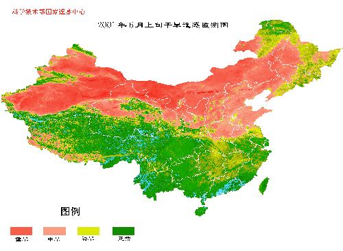
33 Meteorological Disasters Monitoring Meteorological satellites data have been widely used in meteorological research, weather analysis and forecasting. Chinese large-scale drought, frequent floods, typhoons, as well as huge sandstorms, snowstorms and forest fires and so on are in observation and surveillance of China s meteorological satellites. 33

 Observed at 05:58 in 2008.")
34 Meteorological Disasters Monitoring The process of Typhoon Saomai cross China observed by FY-1D satellite. (a) Observed at 05:58 in (b) Observed at 07:29 in


35 Sandstorm monitoring Sandstorm climate distribution map using FY satellites in


36 Geological Disasters Monitoring Wenchuan earthquake Aircraft Remote Sensing image Tangjiashan Barrier Lake 5 月 16 日 19 日 23 日 24 日 25 日 26 日 27 日 Water level monitoring


37 Snowstorm Monitoring Snowstorm Monitoring using CBERS data 2008 January 31, HY-1B coastal zone image Result: large-scale snow cover in Anhui & Jiangsu provinces January 31, HY-1B water color image Result: large-scale snow cover in southern provinces


38 Drought Monitoring The following figures show the TBB (Black body temperature) sequence charts observed by FY-2C from to Sequence charts in
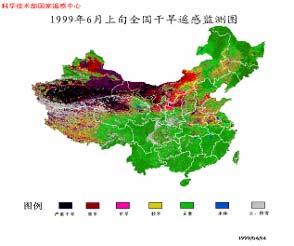
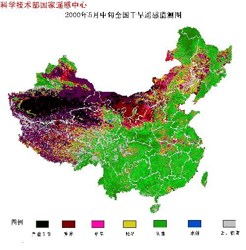
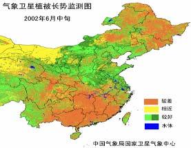
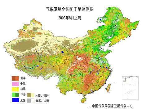
39 Drought Monitoring


40 Marine monitoring 2002 June15 Red tide zone observed by HY-1A CCD camera in Liaodong Bay, China September, red tide in Donghai


41 Marine monitoring Actual Measurement Thickness concentration edge Forecasting Derived the results with high accuracy and timeliness through Improving forecasting initial field

 4.")


42 Ecological Environment Monitoring 吸收 / 散射系数 (m -1 ) λ 1 λ 2 λ 3 a_w ater a_c hla a_trip to n a_c D O M bb Cyanobacteria monitoring using CBERS and MODIS in Taihu lake area in 波长 (nm ) 42
43 Post-disaster (reconstruction) Damage assessment forest fire assessment; house collapse assessment ; snow disaster assessment; stricken population assessment; Reconstruction planning after the disaster


44 Damage Assessment Houses damage assessment map of Wenchuan earthquake Houses damage assessment map of Haiti earthquake


45 Damage Assessment Damage assessment of southern snow disaster


46 reconstruction Reconstruction planning of Wenchuan earthquake Secondary disaster risk evaluation of mountain areas Suitability evaluation of reconstruction
47 Contents Future Tendency 47
48 Tendency High spatial resolution and wide coverage Improvement on precision, sub-meter -> Centimeter (margin) Improvement on efficiency, wide coverage Multi-Spectral, total band, entire angular range detecting and quantitative application of remote sensing spectral resolution to nm level Fully-polarized SAR, InSAR new spectrums Combination of small satellites and regular satellites platform->payload agile satellite with high-performance multi-pattern imagery rapid reaction and flexible operation on attitude control synchronous detecting of multi-payload 48


49 The end The bridge which connect data acquisition, information integration and decision-making support. Breakthrough of key technology Establishment of disaster information product system Data acquisition Data integration Information mining information integration Scientific analysis Information sharing Information Application Construction of Disaster space information infrastructure and its application
50 The end China is greatly developing earth observation system, the high-resolution earth observation system is being constructed and spatial information infrastructure of national natural disasters is being demonstrated. The space-aviation-ground integrated earth observation system is playing more and more important role in the disaster mitigation. China is prepared for promoting the sharing of data and information technology to cope with natural disaster with other countries together.

51 THANK YOU! 51
National Remote Sensing Center of China. Space Technology for Sustainable Development in China Status, Achievements and Futures.
 National Remote Sensing Center of China Space Technology for Sustainable Development in China Status, Achievements and Futures Jing Li National Remote Sensing Center of China Ministry of Science and Technology,
Status and Data Applications of China Highresolution Earth Observation System. Earth Observation System and Data Center, CNSA Sep, 2016
 Status and Data Applications of China Highresolution Earth Observation System Earth Observation System and Data Center, CNSA Sep, 2016 Outlines Introduction Development of the Space-based System CHEOS
Emerging Needs, Challenges and Response Strategy
 Emerging Needs, Challenges and Response Strategy Development of Integrated Observing Systems in China JIAO Meiyan Deputy Administrator China Meteorological Administration September 2011 Geneva Outline
Progress of Space Technology Application for Disaster Management in China
 Progress of Space Technology Application for Disaster Management in China LI Qun Department of Disaster Relief Ministry of Civil Affairs of P.R.China Background drought 1 2 flood earthquake typhoon Progress
HY-2A Satellite User s Guide
 National Satellite Ocean Application Service 2013-5-16 Document Change Record Revision Date Changed Pages/Paragraphs Edit Description i Contents 1 Introduction to HY-2 Satellite... 1 2 HY-2 satellite data
Possible Abnormal Phenomenon of the Atmospheric Water Vapor before Hengchun Earthquake
 PIERS ONLINE, VOL. 6, NO. 1, 2010 21 Possible Abnormal Phenomenon of the Atmospheric Water Vapor before Hengchun Earthquake Yuntao Ma 1, 3, Yiyang Zhao 1, Shanjun Liu 1, and Lixin Wu 1, 2 1 Institute for
Recent development of the National Hydro-Meteorological Service (NHMS) of Viet Nam for disaster risk reduction
 of Viet Nam for disaster risk reduction") Ministry of Natural Resources and Environment National Hydro-Meteorological Service Recent development of the National Hydro-Meteorological Service (NHMS) of Viet Nam for disaster risk reduction Tran Van
Ministry of Natural Resources and Environment National Hydro-Meteorological Service Recent development of the National Hydro-Meteorological Service (NHMS) of Viet Nam for disaster risk reduction Tran Van
CGMS Baseline. Sustained contributions to the Global Observing System. Endorsed by CGMS-46 in Bengaluru, June 2018
 CGMS Baseline Sustained contributions to the Global Observing System Best Practices for Achieving User Readiness for New Meteorological Satellites Endorsed by CGMS-46 in Bengaluru, June 2018 CGMS/DOC/18/1028862,
Interannual variation of MODIS NDVI in Lake Taihu and its relation to climate in submerged macrophyte region
 Yale-NUIST Center on Atmospheric Environment Interannual variation of MODIS NDVI in Lake Taihu and its relation to climate in submerged macrophyte region ZhangZhen 2015.07.10 1 Outline Introduction Data
FUNDAMENTALS OF REMOTE SENSING FOR RISKS ASSESSMENT. 1. Introduction
 FUNDAMENTALS OF REMOTE SENSING FOR RISKS ASSESSMENT FRANÇOIS BECKER International Space University and University Louis Pasteur, Strasbourg, France; E-mail: becker@isu.isunet.edu Abstract. Remote sensing
European Space Agency
 Guidelines - Guidelines how/when to interact during the WebEx session: - Due to the number of attendees, please keep always your webcam and microphone switched-off - You can use anytime the chat to all
METEOSAT THIRD GENERATION
 METEOSAT THIRD GENERATION FACTS AND FIGURES MONITORING WEATHER AND CLIMATE FROM SPACE A HIGHLY INNOVATIVE GEOSTATIONARY SATELLITE SYSTEM FOR EUROPE AND AFRICA The Meteosat Third Generation (MTG) system
CALIBRATION INFRASTRUCTURE AND TYPICAL APPLICATIONS OF CHINA LAND OBSERVATION SATELLITES. Li Liu. Executive summary (corresponding to ca ½ a page)
") Prepared by CNSA Agenda Item: WG.3 CALIBRATION INFRASTRUCTURE AND TYPICAL APPLICATIONS OF CHINA LAND OBSERVATION SATELLITES Li Liu Executive summary (corresponding to ca ½ a page) This report introduces
Prepared by CNSA Agenda Item: WG.3 CALIBRATION INFRASTRUCTURE AND TYPICAL APPLICATIONS OF CHINA LAND OBSERVATION SATELLITES Li Liu Executive summary (corresponding to ca ½ a page) This report introduces
Annex VI-1. Draft National Report on Ocean Remote Sensing in China. (Reviewed by the Second Meeting of NOWPAP WG4)
") UNEP/NOWPAP/CEARAC/WG4 2/9 Page1 Draft National Report on Ocean Remote Sensing in China (Reviewed by the Second Meeting of NOWPAP WG4) UNEP/NOWPAP/CEARAC/WG4 2/9 Page1 1. Status of RS utilization in marine
UNEP/NOWPAP/CEARAC/WG4 2/9 Page1 Draft National Report on Ocean Remote Sensing in China (Reviewed by the Second Meeting of NOWPAP WG4) UNEP/NOWPAP/CEARAC/WG4 2/9 Page1 1. Status of RS utilization in marine
The Delaware Environmental Monitoring & Analysis Center
 The Delaware Environmental Monitoring & Analysis Center Tina Callahan Delaware Estuary Science & Environmental Summit 2013 January 27-30, 2013 What is DEMAC? Delaware Environmental Monitoring & Analysis
International Cooperation in Operational Environmental Satellites: The U.S. Experience
 Committee on the Peaceful Uses of Outer Space Science and Technology Sub committee Forty seventh session February 17, 2010 Vienna, Austria International Cooperation in Operational Environmental Satellites:
APPENDIX 2 OVERVIEW OF THE GLOBAL PRECIPITATION MEASUREMENT (GPM) AND THE TROPICAL RAINFALL MEASURING MISSION (TRMM) 2-1
 AND THE TROPICAL RAINFALL MEASURING MISSION (TRMM) 2-1") APPENDIX 2 OVERVIEW OF THE GLOBAL PRECIPITATION MEASUREMENT (GPM) AND THE TROPICAL RAINFALL MEASURING MISSION (TRMM) 2-1 1. Introduction Precipitation is one of most important environmental parameters.
APPENDIX 2 OVERVIEW OF THE GLOBAL PRECIPITATION MEASUREMENT (GPM) AND THE TROPICAL RAINFALL MEASURING MISSION (TRMM) 2-1 1. Introduction Precipitation is one of most important environmental parameters.
The Spatial Information Corridor Contributes to UNISPACE+50. JIANG HUI Director of Internation Cooperation Department
 The Spatial Information Corridor Contributes to UNISPACE+50 JIANG HUI Director of Internation Cooperation Department 01 02 03 What is Belt & Road Spatial Information Corridor? China put forward the "Belt
sentinel-2 COLOUR VISION FOR COPERNICUS
 sentinel-2 COLOUR VISION FOR COPERNICUS SATELLITES TO SERVE By providing a set of key information services for a wide range of practical applications, Europe s Copernicus programme is providing a step
- satellite orbits. Further Reading: Chapter 04 of the text book. Outline. - satellite sensor measurements
 (1 of 12) Further Reading: Chapter 04 of the text book Outline - satellite orbits - satellite sensor measurements - remote sensing of land, atmosphere and oceans (2 of 12) Introduction Remote Sensing:
Ocean Observation from Haiyang Satellites:
 SPACE SCIENCE ACTIVITIES IN CHINA Ocean Observation from Haiyang Satellites: 2012 2014 AUTHORS JIANG Xingwei LIN Mingsen National Satellite Ocean Application Service, Beijing 100081 ABSTRACT During 2012
GEOG Lecture 8. Orbits, scale and trade-offs
 Environmental Remote Sensing GEOG 2021 Lecture 8 Orbits, scale and trade-offs Orbits revisit Orbits geostationary (36 000 km altitude) polar orbiting (200-1000 km altitude) Orbits revisit Orbits geostationary
Towards eenvironment Prague, March GMES Space Component. Josef Aschbacher Head, ESA GMES Space Office
 Towards eenvironment Prague, 25-27 March 2009 GMES Space Component Josef Aschbacher Head, ESA GMES Space Office Prague from Space Segment 2 05 Nov 2003 CNES 2003 GISAT 2007 ESA GSELAND GMES is an EU led
Activities and Outlook related to Disaster Reduction in CMA
 Activities and Outlook related to Disaster Reduction in CMA WANG Bangzhong China Meteorological Administration March 15-17 2006 ADENDA Situation about MD and related disasters in CHINA Guidance for MD/RD
Brief introduction to. National Satellite Meteorological Center, CMA. Jinsong Wang Deputy Director-General NSMC/CMA
 Brief introduction to National Satellite Meteorological Center, CMA Jinsong Wang Deputy Director-General NSMC/CMA Rio de Janerio, Oct. 12-15, 10 Beijing Guangzhou Urumuqi Jiamusi 2 NSMC DPC@NSMC KIRUNA
Infrastructure monitoring using SAR interferometry
 Infrastructure monitoring using SAR interferometry Hossein Nahavandchi Roghayeh Shamshiri Norwegian University of Science and Technology (NTNU), Department of Civil and Environmental Engineering Geodesy
The Status Report of FY-2F
 Seventh Session of the Expert Team on Satellite Utilization and Products The Status Report of FY-2F Presented by Xiang Fang National Satellite Meteorological Center (NSMC) China Meteorological Administration
Principles of Satellite Remote Sensing
 Chapter 5 Principles of Satellite Remote Sensing Goal: Give a overview on the characteristics of satellite remote sensing. Satellites have several unique characteristics which make them particularly useful
Fundamentals of Remote Sensing
 Division of Spatial Information Science Graduate School Life and Environment Sciences University of Tsukuba Fundamentals of Remote Sensing Prof. Dr. Yuji Murayama Surantha Dassanayake 10/6/2010 1 Fundamentals
Remote Sensing I: Basics
 Remote Sensing I: Basics Kelly M. Brunt Earth System Science Interdisciplinary Center, University of Maryland Cryospheric Science Laboratory, Goddard Space Flight Center kelly.m.brunt@nasa.gov (Based on
Grade 8 Learning Objectives MS-PS2-4.
 MS-PS2-4. Construct and present arguments using evidence to support the claim that gravitational interactions are attractive and depend on the masses of interacting objects. [Clarification Statement: Examples
Surface Connects Author Index
 Surface Connects Author Index Shixin WANG, Yi ZHOU, Gewei LI, Weiqi ZHOU, Yalan LIU & Shirong CHEN NETWORK PLATFORM OF REMOTE SENSING FOR NATURAL DISASTER MONITORING & INFORMATION SERVING AND ITS APPLICATIONS
Challenges for the operational assimilation of satellite image data in agrometeorological models
 Challenges for the operational assimilation of satellite image data in agrometeorological models Mark Danson Centre for Environmental Systems Research, University of Salford, UK 0 Objectives The main objective
Mapping Coastal Change Using LiDAR and Multispectral Imagery
 Mapping Coastal Change Using LiDAR and Multispectral Imagery Contributor: Patrick Collins, Technical Solutions Engineer Presented by TABLE OF CONTENTS Introduction... 1 Coastal Change... 1 Mapping Coastal
Improving global coastal inundation forecasting WMO Panel, UR2014, London, 2 July 2014
 Improving global coastal inundation forecasting WMO Panel, UR2014, London, 2 July 2014 Cyclone Sidr, November 2007 Hurricane Katrina, 2005 Prof. Kevin Horsburgh Head of marine physics, UK National Oceanography
Fifty Years of Operational Environmental Satellites: The U.S. Experience
 United Nations Committee on the Peaceful Uses of Outer Space Vienna, Austria June 15, 2010 Fifty Years of Operational Environmental Satellites: The U.S. Experience Mr. Charles Baker Deputy Assistant Administrator
The known requirements for Arctic climate services
 The known requirements for Arctic climate services based on findings described in STT White paper 8/2015 Johanna Ekman / EC PHORS STT Regional drivers The Arctic region is home to almost four million people
Application Status and Prospect of Microwave Remote Sensing
 2017 International Conference on Computing, Communications and Automation(I3CA 2017) Application Status and Prospect of Microwave Remote Sensing Cheng Lele, Yan Xinsui, Zhou Mengqiu, Zhou Yongqin, Wang
Intelligent City Management
 Intelligent City Management Based on Land Cover Feature Changes Detected by Satellite Imagery Twenty First Century Aerospace Technology (21AT) www.21at.com.cn Geospatial World Forum 2016 Outline 01 Introduction
A Regional Microsatellite Constellation with Electric Propulsion In Support of Tuscan Agriculture
 Berlin, 20 th - 24 th 2015 University of Pisa 10 th IAA Symposium on Small Satellites for Earth Observation Student Conference A Regional Microsatellite Constellation with Electric Propulsion In Support
Preliminary assessment of socio-economic benefits from CMA Meteorological Satellite Programmes. Dr. ZHENG Guoguang / YANG Jun
 Preliminary assessment of socio-economic benefits from CMA Meteorological Satellite Programmes Dr. ZHENG Guoguang / YANG Jun China Meteorological Administration CMA report to CM-12 WMO HQ, June 21, 2014
SAWS: Met-Ocean Data & Infrastructure in Support of Industry, Research & Public Good. South Africa-Norway Science Week, 2016
 SAWS: Met-Ocean Data & Infrastructure in Support of Industry, Research & Public Good South Africa-Norway Science Week, 2016 Marc de Vos, November 2016 South Africa: Context http://learn.mindset.co.za/sites/default/files/resourcelib/e
Japanese Programs on Space and Water Applications
 Japanese Programs on Space and Water Applications Tamotsu IGARASHI Remote Sensing Technology Center of Japan June 2006 COPUOS 2006 Vienna International Centre Water-related hazards/disasters may occur
Radio Frequency Earth Science
 Radio Frequency Earth Science Overview for Committee On Radio Frequency (CORF) National Academy of Science National Research Council April 27, 2005 Bill.Watson@NASA.Gov Program Executive for Ground Networks
Effective Utilization of Synthetic Aperture Radar (SAR) Imagery in Rapid Damage Assessment
 Imagery in Rapid Damage Assessment") Effective Utilization of Synthetic Aperture Radar (SAR) Imagery in Rapid Damage Assessment Case Study Pakistan Floods SUPARCO M. Maisam Raza, Ahmad H. Rabbani SEQUENCE Flood Monitoring using Satellite
Effective Utilization of Synthetic Aperture Radar (SAR) Imagery in Rapid Damage Assessment Case Study Pakistan Floods SUPARCO M. Maisam Raza, Ahmad H. Rabbani SEQUENCE Flood Monitoring using Satellite
Report on Disaster statistics of Nepal
 Report on Disaster statistics of Nepal Submitted by Altaf Rehman Submitted to Dr. Naveed Ahmed University of engineering and technology Peshawar Assignment 1 Section A Registration id 14PWCIV456 Page 1
VISION FOR THE GOS IN 2025 ( Approved by CBS-XIV and Adopted by EC LXI in June 2009)
") WORLD METEOROLOGICAL ORGANIZATION Weather Climate Water VISION FOR THE GOS IN 2025 ( Approved by CBS-XIV and Adopted by EC LXI in June 2009) PREAMBLE This Vision provides high-level goals to guide the
WORLD METEOROLOGICAL ORGANIZATION Weather Climate Water VISION FOR THE GOS IN 2025 ( Approved by CBS-XIV and Adopted by EC LXI in June 2009) PREAMBLE This Vision provides high-level goals to guide the
Development of Tropical cyclone objective analysis technique based on FY serial satellite data
 2 nd International Workshop On Satellite Analysis of Tropical Cyclones (IWSATC-2) Update on Objective Satellite-Based TC Analysis Methods 18 February 2016 Honolulu, Hawaii, USA Development of Tropical
CGMS Baseline In response to CGMS action/recommendation A45.01 HLPP reference: 1.1.8
 Prepared by WGIII Agenda Item: 7.1 Discussed in WGIII CGMS Baseline In response to CGMS action/recommendation A45.01 HLPP reference: 1.1.8 In CGMS-45, Working Group III agreed to hold a review of the CGMS
The ESA Earth observation programmes overview and outlook
 The ESA Earth observation programmes overview and outlook Dr. Volker Liebig Director, ESA EO Programmes ILA 2008, Berlin ENVISAT mission: 6 years! Bam earthquake Tectonic uplift (Andaman) Arctic 2007 First
Comprehensive Earth Science
 Comprehensive Earth Science COURSE DESCRIPTION: This course provides students with a comprehensive earth science curriculum, focusing on geology, oceanography, astronomy, weather, and climate. The program
Ganbat.B, Agro meteorology Section
 NATIONAL AGENCY FOR METEOROLOGY, HYDROLOGY AND ENVIRONMENT MONITORING OF MONGOLIA Ganbat.B, Agro meteorology Section OF INSTITUTE OF METEOROLOGY AND HYDROLOGY 2009 YEAR Location Climate Northern Asia,
Introduction of the Asia-Oceania Global Earth Observation System of Systems (AOGEOSS) GEO Initiative(GI-22 )
 GEO Initiative(GI-22 )") Introduction of the Asia-Oceania Global Earth Observation System of Systems (AOGEOSS) GEO Initiative(GI-22 ) Prof. Xiang ZHOU Institute of Remote Sensing and Digital Earth, CAS 11 May 2017 Kunming, China
Introduction of the Asia-Oceania Global Earth Observation System of Systems (AOGEOSS) GEO Initiative(GI-22 ) Prof. Xiang ZHOU Institute of Remote Sensing and Digital Earth, CAS 11 May 2017 Kunming, China
VNREDSat-1. Vietnam Natural Resources, Environment and Disaster monitoring Satellite. Lai Anh Khoi SPACE TECHNOLOGY INSTITUTE
 VNREDSat-1 Vietnam Natural Resources, Environment and Disaster monitoring Satellite Lai Anh Khoi SPACE TECHNOLOGY INSTITUTE JPTM2014 Yangon, Nov. 19-21, 2014 General information (1) Project Owner: Vietnam
Copernicus Today and Tomorrow GEO Week Group on Earth Observation Geneva, 16 January 2014 The Copernicus Space Infrastructure
 Copernicus Today and Tomorrow GEO Week Group on Earth Observation Geneva, 16 January 2014 The Copernicus Space Infrastructure Thomas Beer, Policy Coordinator, Copernicus Space Office, ESA-ESRIN, Frascati
GOES-R Instrument Status and Accommodations. Barbara Pfarr GOES-R Program Systems Engineering January 2010 AMS Conference
 GOES-R Instrument Status and Accommodations Barbara Pfarr GOES-R Program Systems Engineering January 2010 AMS Conference Agenda Instrument Developmental Status Significant Changes in the Last Year Introducing
Atmospheric correction of HJ1-A/B images and the effects on remote sensing monitoring of cyanobacteria bloom
 Remote Sensing and GIS for Hydrology and Water Resources (IAHS Publ. 368, 2015) (Proceedings RSHS14 and ICGRHWE14, Guangzhou, China, August 2014). 69 Atmospheric correction of HJ1-A/B images and the effects
Add NOAA nowcoast Layers to Maps
 WebEOC Maps Add-on Quick Reference Guide Add NOAA nowcoast Layers to Maps Overview With Maps Add-on, you can configure an unlimited number of map layers. These layers allow you to control the data you
CEOS Landslide Pilot Chinese Region:
 CEOS Working Group on Disasters Meeting #9 CEOS Landslide Pilot Chinese Region: a recent progress Ziyang Li zyli@aoe.ac.cn Key Laboratory of Quantitative Remote Sensing Information Technology, Academy
Surface Anomalies Prior to Earthquakes
 Surface Anomalies Prior to Earthquakes Habibeh Valizadeh, Shattri B. Mansor Husaini Omar and Farid Azad Department of Civil Engineering Universiti Putra Malaysia Serdang, Selangor Malaysia shattri@eng.upm.edu.my
JAXA s satellites for Disaster Risk Reduction
 JAXA s satellites for Disaster Risk Reduction October 9, 2017 Masanobu TSUJI Japan Aerospace Exploration Agency (JAXA) Panel on Space Technology and Applications in Support of theregional Roadmap for Implementing
sentinel-3 A BIGGER PICTURE FOR COPERNICUS
 sentinel-3 A BIGGER PICTURE FOR COPERNICUS SATELLITES TO SERVE By providing a set of key information services for a wide range of practical applications, Europe s Copernicus programme has been put in place
Current Status of the ALOS-2 Operation and PALSAR-2 Calibration Activities
 Current Status of the ALOS-2 Operation and PALSAR-2 Calibration Activities Takeshi Motohka, Ryo Natsuaki, Yukihiro Kankaku, Shinichi Suzuki, Masanobu Shimada (JAXA) Osamu Isoguchi (RESTEC) CEOS SAR CALVAL
FLORA: FLood estimation and forecast in complex Orographic areas for Risk mitigation in the Alpine space
 Natural Risk Management in a changing climate: Experiences in Adaptation Strategies from some European Projekts Milano - December 14 th, 2011 FLORA: FLood estimation and forecast in complex Orographic
Assessing Hazards and Risk
 Page 1 of 6 EENS 204 Tulane University Natural Disasters Prof. Stephen A. Nelson Assessing Hazards and Risk This page last updated on 07-Jan-2004 As discussed before, natural disasters are produced by
GEO New Mission and Synergy Joo-Hyung Ryu
 GEO New Mission and Synergy Joo-Hyung Ryu Korea Ocean Satellite Center Korea Institute Ocean Sciences & Technology GEMS GOCI-II GOCI Development : KARI & KIOST Cooperation Development Payload system -
EUMETSAT STATUS AND PLANS
 1 EUM/TSS/VWG/15/826793 07/10/2015 EUMETSAT STATUS AND PLANS François Montagner, Marine Applications Manager, EUMETSAT WMO Polar Space Task Group 5 5-7 October 2015, DLR, Oberpfaffenhofen PSTG Strategic
Status report on current and future satellite systems by EUMETSAT Presented to CGMS-44, Plenary session, agenda item D.1
 Status report on current and future satellite systems by EUMETSAT Presented to CGMS-44, Plenary session, agenda item D.1 CGMS-44-EUMETSAT-WP-19.ppt, version 1 (# 859110), 8 June 2016 MISSION PLANNING YEAR...
Research on the Chinese Space Station. April 20,2012 SPACE RESEARCH INFORMATION DAY
 Research on the Chinese Space Station April 20,2012 SPACE RESEARCH INFORMATION DAY Content 1. Brief of the China s Manned Space Engineering Program 2. Introduction of GESSA (CSU), CAS 3. Utilization on
Emergency Management Service (EMS) mapping
 mapping") GMES Emergency Management Service (EMS) mapping Frédéric BASTIDE GMES unit, European Commission UN-SPIDER Expert Meeting: "Crowdsource Mapping for Disaster Risk Management and Emergency Response" 3-5 December,
GMES Emergency Management Service (EMS) mapping Frédéric BASTIDE GMES unit, European Commission UN-SPIDER Expert Meeting: "Crowdsource Mapping for Disaster Risk Management and Emergency Response" 3-5 December,
UK-DMC 2 and Deimos-1, New DMC Sensors for Agricultural Monitoring. Owen Hawkins DMC International Imaging Ltd
 UK-DMC 2 and Deimos-1, New DMC Sensors for Agricultural Monitoring Owen Hawkins DMC International Imaging Ltd Full Spectrum Satellite Solutions Design Manufacture Assembly, Integration & Test Launch Services
RUSSIAN EARTH OBSERVATION MISSIONS: satellites, ground segment and data access evolution
 RUSSIAN EARTH OBSERVATION MISSIONS: satellites, ground segment and data access evolution Tamara Ganina Deputy Chief of Prospective Development Dep. WGISS-40 UKSA, Harwell, UK September 28 October 2, 2015
Physical Geography: Patterns, Processes, and Interactions, Grade 11, University/College Expectations
 Geographic Foundations: Space and Systems SSV.01 explain major theories of the origin and internal structure of the earth; Page 1 SSV.02 demonstrate an understanding of the principal features of the earth
DISTRIBUTION AND DIURNAL VARIATION OF WARM-SEASON SHORT-DURATION HEAVY RAINFALL IN RELATION TO THE MCSS IN CHINA
 3 DISTRIBUTION AND DIURNAL VARIATION OF WARM-SEASON SHORT-DURATION HEAVY RAINFALL IN RELATION TO THE MCSS IN CHINA Jiong Chen 1, Yongguang Zheng 1*, Xiaoling Zhang 1, Peijun Zhu 2 1 National Meteorological
Remote Sensing in Meteorology: Satellites and Radar. AT 351 Lab 10 April 2, Remote Sensing
 Remote Sensing in Meteorology: Satellites and Radar AT 351 Lab 10 April 2, 2008 Remote Sensing Remote sensing is gathering information about something without being in physical contact with it typically
SPACE TECHNOLOGY INSTITUTE, VNREDSat-1 and DATA PROVIDER NODE (DPN) REPORT
 REPORT") 4th Joint Project Team Meeting for Sentinel Asia STEP3 (JPTM2017) 8-9 March 2017 SPACE TECHNOLOGY INSTITUTE, VNREDSat-1 and DATA PROVIDER NODE (DPN) REPORT www.sti.vast.ac.vn CONTENT 1. Overview of Space
4th Joint Project Team Meeting for Sentinel Asia STEP3 (JPTM2017) 8-9 March 2017 SPACE TECHNOLOGY INSTITUTE, VNREDSat-1 and DATA PROVIDER NODE (DPN) REPORT www.sti.vast.ac.vn CONTENT 1. Overview of Space
Geospatial application in Kiribati
 Geospatial application in Kiribati ICC-21 ST RESAP (9 TH TO 13 TH OCTOBER, 2017) BANGKOK, THAILAND Outline Kiribati Profile Natural disasters in Kiribati Achievements Challenges/Issues Ways forward 1 Kiribati
Teruyuki Nakajima Director, Earth Observation Research Center (EORC) Japan Aerospace Exploration Agency (JAXA)
 Japan Aerospace Exploration Agency (JAXA)") Tokyo Inter. Conference on the Forest Governance Initiative - Improving Forest Governance using Forest Early Warning Systems and Satellite Technologies - October 24-26, 2017 Teruyuki Nakajima Director,
Tokyo Inter. Conference on the Forest Governance Initiative - Improving Forest Governance using Forest Early Warning Systems and Satellite Technologies - October 24-26, 2017 Teruyuki Nakajima Director,
JCOMM-CHy Coastal Inundation Forecasting Demonstration Project (CIFDP)
") WMO World Meteorological Organization Working together in weather, climate and water JCOMM-CHy Coastal Inundation Forecasting Demonstration Project (CIFDP) Coastal Flooding & Vulnerable Populations Coastal
WMO World Meteorological Organization Working together in weather, climate and water JCOMM-CHy Coastal Inundation Forecasting Demonstration Project (CIFDP) Coastal Flooding & Vulnerable Populations Coastal
Report from CNSA 16th GSICS Executive Panel, Boulder, May 2015
 Report from CNSA 16th GSICS Executive Panel, Boulder, 15-16 May 2015 Peng Zhang, Jun Gao Satellite Introdution GF-1 satellite mission GF-1 satellite is the first CHEOS constellation satellite launched
Performance and Application of CSPP/IMAPP in East China
 Performance and Application of CSPP/IMAPP in East China Yan-An Liu 1, Wei Gao 1, Runhe Shi 1, Allen Huang 2, Kathy Strabala 2, Liam Gumley 2 1. East China Normal University 2. University of Wisconsin-Madison
Understanding Weather and Climate Risk. Matthew Perry Sharing an Uncertain World Conference The Geological Society, 13 July 2017
 Understanding Weather and Climate Risk Matthew Perry Sharing an Uncertain World Conference The Geological Society, 13 July 2017 What is risk in a weather and climate context? Hazard: something with the
Earth Observation in coastal zone MetOcean design criteria
 ESA Oil & Gas Workshop 2010 Earth Observation in coastal zone MetOcean design criteria Cees de Valk BMT ARGOSS Wind, wave and current design criteria geophysical process uncertainty modelling assumptions
The current status of FY-3D. (Submitted by Xiang Fang, CMA) Summary and Purpose of Document
 Summary and Purpose of Document") WORLD METEOROLOGICAL ORGANIZATION COMMISSION FOR BASIC SYSTEMS OPEN PROGRAMME AREA GROUP ON INTEGRATED OBSERVING SYSTEMS INTER-PROGRAMME EXPERT TEAM ON SATELLITE UTILIZATION AND PRODUCTS FOURTH SESSION
WORLD METEOROLOGICAL ORGANIZATION COMMISSION FOR BASIC SYSTEMS OPEN PROGRAMME AREA GROUP ON INTEGRATED OBSERVING SYSTEMS INTER-PROGRAMME EXPERT TEAM ON SATELLITE UTILIZATION AND PRODUCTS FOURTH SESSION
Introdution. Geography. Country overview
 The 5th Meeting of the Coordinating Group of the RA II WIGOS Satellite Project 21 October, Vladivostok city, Russky Island, Russia Far Eastern Federal University Tajikistan report Agency for Hydrometeorology
OVERVIEW OF IMPROVED USE OF RS INDICATORS AT INAM. Domingos Mosquito Patricio
 OVERVIEW OF IMPROVED USE OF RS INDICATORS AT INAM Domingos Mosquito Patricio domingos.mosquito@gmail.com Introduction to Mozambique /INAM Introduction to AGRICAB/SPIRITS Objectives Material & Methods Results
Themes for Geomatics Conference. Geodesy Themes
 Themes for Geomatics Conference Geodesy Themes Geodynamics o Modeling the Deformation of the Earth s Crust o Recent Advances in Geometric Approaches to Deformation Analysis o Monitoring Systems (Sensors
Workshop on Drought and Extreme Temperatures: Preparedness and Management for Sustainable Agriculture, Forestry and Fishery
 Workshop on Drought and Extreme Temperatures: Preparedness and Management for Sustainable Agriculture, Forestry and Fishery 16-17 Feb.2009, Beijing, China Modeling Apple Tree Bud burst time and frost risk
Bistandsprosjekter i Sørøst-Asia
 Bistandsprosjekter i Sørøst-Asia -Sikre liv og verdier Lars R. Hole, Hanneke Luijting, Tor Ivar Mathisen og Kristine Gjesdal September 2017 Norwegian Meteorological Institute Background Ministry of Foreign
CONTENTS CHAPTER 1: PROLOGUE The Local Environment... 1 Observation, Inference, Classification Properties of the Environment...
 CONTENTS CHAPTER 1: PROLOGUE The Local Environment... 1 Observation, Inference, Classification Properties of the Environment... 3 Measurement, Percent Deviation From Accepted Value Density... 6 Density
Copernicus Overview. Major Emergency Management Conference Athlone 2017
 Copernicus Overview Major Emergency Management Conference Athlone 2017 Copernicus is a European programme implemented by the European Commission. The services address six thematic areas: land, marine,
A MODEL FOR RISES AND DOWNS OF THE GREATEST LAKE ON EARTH
 A MODEL FOR RISES AND DOWNS OF THE GREATEST LAKE ON EARTH Parviz Tarikhi Iranian Remote Sensing Center, Iran May 2005 1 Figure 1: West of Novshahr in the Iranian coast of Caspian; the dam constructed to
New Concept of Regional Cooperation in Asia for Water Disaster Management Applying Satellite Precipitation Measurement
 New Concept of Regional Cooperation in Asia for Water Disaster Management Applying Satellite Precipitation Measurement Yusuke Muraki Japan Aerospace Exploration Agency (JAXA) Mission Planning Department
Imaging the whole Earth every day. Josh Alban VP, Business Development
 Imaging the whole Earth every day Josh Alban VP, Business Development josh@planet.com Planet Labs helps you detect and act on change by imaging the whole Earth everyday. Challenges Limited Coverage Low
Satellite Remote Sensing for Ocean
 Satellite Remote Sensing for Ocean August 17, 2017 Masatoshi Kamei RESTEC All rights reserved RESTEC 2015 Contents 1. About RESTEC and Remote Sensing 2. Example of Remote Sensing Technology 3. Remote Sensing
Mandatory Assignment 2013 INF-GEO4310
 Mandatory Assignment 2013 INF-GEO4310 Deadline for submission: 12-Nov-2013 e-mail the answers in one pdf file to vikashp@ifi.uio.no Part I: Multiple choice questions Multiple choice geometrical optics
NEW CGMS BASELINE FOR THE SPACE-BASED GOS. (Submitted by the WMO Secretariat) Summary and Purpose of Document
 Summary and Purpose of Document") WORLD METEOROLOGICAL ORGANIZATION COMMISSION FOR BASIC SYSTEMS OPEN PROGRAMME AREA GROUP ON INTEGRATED OBSERVING SYSTEMS EXPERT TEAM ON SATELLITE SYSTEMS ET-SAT-7/Inf. 2 (12.III.2012) ITEM: 8.1 SEVENTH
WORLD METEOROLOGICAL ORGANIZATION COMMISSION FOR BASIC SYSTEMS OPEN PROGRAMME AREA GROUP ON INTEGRATED OBSERVING SYSTEMS EXPERT TEAM ON SATELLITE SYSTEMS ET-SAT-7/Inf. 2 (12.III.2012) ITEM: 8.1 SEVENTH
WEATHER AND CLIMATE EXTREMES MONITORING BASED ON SATELLITE OBSERVATION : INDONESIA PERSPECTIVE RIRIS ADRIYANTO
 WEATHER AND CLIMATE EXTREMES MONITORING BASED ON SATELLITE OBSERVATION : INDONESIA PERSPECTIVE RIRIS ADRIYANTO INDONESIA AGENCY FOR METEOROLOGY, CLIMATOLOGY AND GEOPHYSICS (BM KG) 1. INTRODUCTION - BMKG
A two-season impact study of the Navy s WindSat surface wind retrievals in the NCEP global data assimilation system
 A two-season impact study of the Navy s WindSat surface wind retrievals in the NCEP global data assimilation system Li Bi James Jung John Le Marshall 16 April 2008 Outline WindSat overview and working
Great Lakes Information Network GIS (Queryable by topic, geography, organization, and upload date 73 layers as of October, 2009)
") Google Earth Files for the Great Lakes and Beyond GLOS Mapping Workshop Alpena, Michigan November 9, 2009 David Hart GIS Specialist University of Wisconsin Sea Grant Institute GREAT LAKES Great Lakes Information
Google Earth Files for the Great Lakes and Beyond GLOS Mapping Workshop Alpena, Michigan November 9, 2009 David Hart GIS Specialist University of Wisconsin Sea Grant Institute GREAT LAKES Great Lakes Information