Eastern United States Synoptic Rain Event May 2014-Draft
|
|
|
- Jonas Byrd
- 5 years ago
- Views:
Transcription
1 1. Overview Eastern United States Synoptic Rain Event May 2014-Draft heavy rain and flooding event By Richard H. Grumm National Weather Service State College, PA A deep 500 hpa trough with -4σ height anomalies over the central United States (Fig. 1) combined with a strong ridge with +2σ height anomalies over eastern Canada, produced strong southerly flow. The deep southerly flow brought a plume of high precipitable water (PW: Fig. 2) air into the region along with strong 850 hpa southerly flow (Fig. 3) resulting in heavy rainfall (Fig. 4) and isolated severe weather (Fig. 5). The heavy rainfall produced flooding in the Mid- Atlantic region from Virginia northward into New York State. The pattern was well predicted by the NCEP models and ensemble forecasts systems. The NCEP SREF will be used to illustrate the successful prediction of the larger scale pattern. The precipitation forecasts showed some uncertainty as to the amounts and locations of the heavy rainfall though all forecasts systems correctly predicted the potential for heavy rainfall in the general region where the rainfall was observed. The paper will provide an overview of the pattern, the resulting weather, and forecasts of the rainfall. The brief, local severe weather which affected central Pennsylvania is also examined including a mini-supercell which did not produce severe weather. The most significant impact on the region was heavy rainfall with areas where 50 to 150 mm (2-6 inches: Table 1) of rain was observed and the resulting flooding along streams and creeks. 2. Data and Methods The large scale pattern was reconstructed using the 00-hour forecast of the NCEP Global Forecast System as first guess at the verifying pattern. The standardized anomalies were computed in Hart and Grumm (2001). All data were displayed using GrADS (Doty and Kinter 1995). The focus on the larger scale pattern was to show the standardized anomalies and how they helped identify this event and the potential they have in anticipating similar high impact weather events (HIWE). The NCEP GFS, GEFS, and SREF were used to examine the forecasts of this event. As the pattern was generally well predicted the focus is on the quantitative precipitation forecast (QPF) produced by these systems. The stage-iv data were used to get a first guess at where, when, and how much precipitation was observed. These data were analyzed in planview with GrADS and in Python to make point
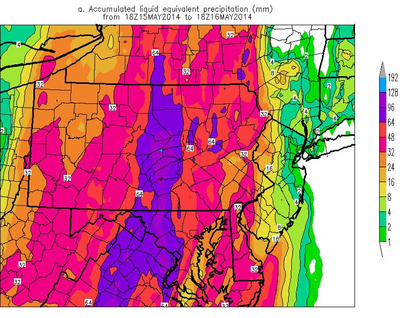
2 diagrams showing the timing of the rainfall. Python was used to plot all-time series and plume diagrams. Radar imagery was obtained from the local AWIPS in State College and QPE data was examine using the Stage-IV data. 3. Pattern and Weather i. pattern The large scale pattern (Figs. 1-3) showed a deep trough to the west and a strong ridge to the east. The resulting deep southerly flow allowed a surge of deep moisture and strong southerly flow into the eastern United States. A nearly textbook Maddox Synoptic rainfall (Maddox et al. 1979) event type. There was some shallow cold air damming and easterly flow which likely enhanced the lift over the frontal boundary in the Mid-Atlantic region contributing to the rainfall amounts in some areas in excess of 5 inches. The surface pattern, Figure 6 shows the surface pattern, which indicated a strong surface anticyclone off the East Coast and a large anticyclone over the central United States. Several relatively weak cyclones developed in the trough between the two anticyclones. Though not clearly indicated, the strong easterly flow at low-levels pushed a marine layer into central Pennsylvania on 14 May creating an enhanced frontal boundary over which the deep southerly flow (Fig. 3) moved over. It is beyond the scope of this study to show these mesoscale details. ii. rainfall The evolution of the precipitation shield as it moved over the eastern United States (Fig. 4).) shows the areas of 25 mm or more QPF. The first 3-panels show the 12-hour windows of the rapidly moving shield of heavy rain from 0000 UTC 15 May through 1200 UTC 16 May Figure 4d shows the 24-hour total, the window when most of the rain fell over Pennsylvania and the Mid-Atlantic region. The rain shield had an abrupt western edge and an embedded northsouth band of 50 mm with a 100 mm area within it over east-central Pennsylvania. It should be noted that two private rain gauges in Spring Mills, PA recorded around 150 mm ( 6inches) of rain just a few 10s of kilometers west of the 100 mm (4 inch) area outlined in the Stage-IV data. These data show the oft observed character of synoptic rainfall events including the sharp northsouth axes of heavy rainfall and the sharp edges of the heavier rainfall. iii. Pennsylvania severe weather The focus here is on three storms, two of storms which produced severe weather in central Pennsylvania and a mini-supercell. The mini-supercell, which developed near Lewistown, PA, and moved to the north-northeast shown near its peak (Fig. 7) was not associated with any known damage. The first severe storm was a bow-echo structure which produced damage north of Harrisburg, PA. The second severe storm was along a line of storms and heavy rain which
3 developed a break in the line and a strong rear flank downdraft near Lock Haven around 2300 UTC. This storm produced some wind damage and a short-lived tornado. The mini-supercell storm which produced wind damage over southern Clinton County and east of Lock Haven, PA is shows (Fig. 8) shows a hook in the reflectivity and a ZDR arc around mesocyclone (see black arc outlining the feature). The base winds (V) show the circulation associated with the low-level mesocyclone. This well-structured mini-supercell has not been associated with any wind damage, though it contained many features found in stronger and more meteorologically significant supercells. The bow echo developed over Cumberland County (Fig. 9) south of Newville and had over 40kts of wind associated with at 2212 UTC. The bow feature in the reflectivity became more pronounced as the feature moved eastward. The final image, at 2249 UTC shows the distinct bow feature well southwest of Amity Hall, which is just north of Duncannon where wind damage was reported. The second known severe storm developed in a line of showers and thunderstorms. It affected an area just west of the area affected by the mini-supercell about an hour later. At 2300 UTC (Fig. 10) the storm showed a classic broken-s pattern, a region where a mesocyclone often develops along a line of thunderstorms (orange arrow) and contains strong outbound velocities (white arrow) peaking over 50 kts. Not the low values of ZDR in the region of the strong velocities in the upper right panel. Higher values of ZDR were present to the east, near Loganton. Figure 11 shows the line as the mesocyclone at was still growing and the break in the line was not complete. The low ZDR region was present near the emergent mesocyclone, the outbound winds were weaker at this time and the break in the line, the broken-s was evident a few kilometers northwest of Mackeyville, PA. This storm produced wind damage and a brief tornado on the east side of Lock Haven, PA around 2300 UTC 15 May Forecasts Forecasts of the larger scale pattern were generally good with about 3-5 days lead-time (not shown). This is revealed by the GEFS QPF (Fig. 12 ) which show the north-south oriented band of rainfall to exceed 50 mm. Forecasts issued prior to 0000 UTC 11 May had some issues with the location of the pattern and rainfall. Due to divergent solutions on the exact location and timing of the rainfall, forecasts issued on and after 1200 UTC 13 May showed the higher probability of 50 mm or more QPF. These data show the 24-hour window in which the heavy rainfall was observed. Higher QPF values were indicated when these GEFS forecasts we re viewed in 30 to 36 hour windows. The NCEP SREF (Fig. 13) showed a similar north-south axis of heavy rainfall from the central Appalachians into southern New York. The axis of the SREF heavy rainfall was west of that
4 produced in the GEFS and similar to the GEFS, showed the heavier rainfall with higher probabilities as the forecast horizon decreased. A comparison of select 0000 UTC GFS, and GEFS with 0300 UTC SREF data are shown in Figure. 14 and 1200 UTC GFS, GEFS with 0900 UTC SREF are shown in Figure 15. These data show similar forecasts by each system with regards to a north-south axis of heavy rainfall and the general area to be impacted by the rainfall. The GFS had higher QPF amounts than the SREF and GEFS though most of this could be attributed to averaging 21 members in the two EFSs. All of these data suggest a well predicted pattern, a synoptic pattern, though the details as to where the higher QPF would fall to have been more of a forecast issue. 5. Summary A strong frontal system ahead of a deep late season trough to the west and a strong ridge to the east brought a surge of deep moisture into the eastern United States resulting in heavy rain in the Mid-Atlantic region. Due to a lack of deep instability, severe weather was generally a low-level issue with this Synoptic-type heavy rainfall event. The heaviest rains fell in a 24 hour period between about 1800 UTC May 2014 (Figs. 4 & 16) from Virginia into central Pennsylvania (Table 1). The heavy rainfall produced flooding along rivers and streams in the Mid-Atlantic region with approximately 34 points reaching or exceeding flood stage (Table 2). Similar to many synoptic events, the heavier rainfall fell in a general north-south oriented band in deeps southerly flow in a plume of air with above normal precipitable water. This is another case which demonstrates the value of anomaly based analysis and forecasting in identifying high impact weather events. This and other cases show the value of anomaly based forecasting in near, short, and medium range forecasting. In this event, the relatively accurate prediction of the anomalous plume of deep moisture and strong low-level southerly flow resulted in relatively useful and accurate QPF forecasts in the NCEP deterministic models and ensemble forecast systems. This relationship between the strong signal in the anomalies and the high QPFs should provide some modicum of confidence information to forecasters predicting heavy rainfall and potential flooding events. The NCEP guidance shown here implied a relatively impressive lead-time on the order of 3-6 days. The heavy rain produced rapid rises on several creeks and streams in central Pennsylvania such as Shermans and Penns Creek (Fig. 17). The black curves show the rapid rises on both creeks. Forecasts of the flooding were relatively slow in showing the flood potential. Similar to many previous events, when widespread rainfall over a basin exceeds 75 mm ( 3 inches), flooding along smaller streams and creeks often occurs. 6. Acknowledgements
5 The Pennsylvania State University for data access and providing students for research and case study projects. Ron Holmes for processing river stages and forecasts. Charles Ross for consultation and editing Elyse Colbert for summarizing observations and rainfall observations. Charlie Chillag for data on river flooding and stages. 7. References Bodner, M. J., N. W. Junker, R. H. Grumm, and R. S. Schumacher, 2011: Comparison of atmospheric circulation patterns during the 2008 and 1993 historic Midwest floods. Natl. Wea. Dig., 35, Doswell,C.A.,III, H.E Brooks and R.A. Maddox, 1996: Flash flood forecasting: ingredients based approach. Wea. Forecasting, 11, Doty, B.E. and J.L. Kinter III, 1995: Geophysical Data Analysis and Visualization using GrADS. Visualization Techniques in Space and Atmospheric Sciences, eds. E.P. Szuszczewicz and J.H. Bredekamp, NASA, Washington, D.C., Durkee, JD., L Campbell, K Berry, D Jordan, G Goodrich, R Mahmood, S Foster, 2012: A Synoptic Perspective of the Record 1-2 May 2010 Mid-South Heavy Precipitation Event. Bull. Amer. Meteor. Soc., 93, doi: Junker, N. W., R. S. Schneider and S. L. Fauver, 1999: Study of heavy rainfall events during the Great Midwest Flood of Wea. Forecasting, 14, Maddox,R.A., C.F Chappell, and L.R. Hoxit. 1979: Synoptic and meso-alpha aspects of flood events. Bull. Amer. Meteor. Soc., 60, flash Stuart, N., Grumm, R. (2009) The Use of Ensemble and Anomaly Data to Anticipate Extreme Flood Events in the Northeastern United States. Nat. Wea. Digest 33:
 and 500 hpa height anomalies (standard deviations) in 12")
6 Figure 1. GFS 00-hour forecasts of 500 hpa heights (m) and 500 hpa height anomalies (standard deviations) in 12 hour increments from a) 0000 UTC 14 May 2014 through f) 1200 UTC 16 May Return to text.
7 Figure 2. As in Figure 1 except for precipitable water (mm) and precipitable water anomalies in 6-hour increments from 0600 UTC 15 May through 1200 UTC 16 May Return to text.

8 Figure 3. As in Figure 2 except for 850 hpa winds and wind anomalies. Return to text.
 1200 UTC 15 May, b) 0000 UTC 16 May, and c) 1200 UTC 16 May 2014 and d) the")
9 Figure 4. Estimated rainfall for amounts of 25mm or greater from the stage-iv rainfall data for the 3 12-hour periods ending at a) 1200 UTC 15 May, b) 0000 UTC 16 May, and c) 1200 UTC 16 May 2014 and d) the 24-hour accumulated rainfall over the period ending at 1800 UTC 16 May The 24 hour period covers the heavy rainfall over Pennsylvania and the Mid-Atlantic region.. Return to text. Return to rainfall portion.

10 Figure 5. Storm reports from Storm Prediction Center. Colored by type. Return to text.

11 Figure 6. As in Figure 3 except for MSLP. Return to text. NWS State College Case Examples
 and base velocity (V)")
")

12 Figure 7. Base reflectivity (Z) and base velocity (V) focused over Centre and southern Clinton counties showing the evolving storm at (top) 2018 UTC, 2123 UTC and 2137 UTC. The hook echo is clear in the latter two images and at least weak rotation is evident in each image. Return to text.
 base reflectivity (Z), differential reflectivity (ZDR), correlation coefficient (CC),")
13 Figure 8. KCCX 4 panel valid at 2137 UTC 15 May 2014 showing (clockwise from upper left) base reflectivity (Z), differential reflectivity (ZDR), correlation coefficient (CC), specific differential phase (KDP). Note ZDR arc in the upper right panel. The ZDR arch is drawn to the left of the feature to highlight it. Return to text.


14 Figure 9. As in Figure. except for 2212, 2239, and 2249 UTC. Return to text.

15 Figure 10. KCCX radar showing 0.5 dgree base reflectivity, ZDR, CC, and winds at 2303 UTC 15 May THe orange arrow show the break or broken- S in the reflectivity data, the pink arrow shows the ZDR minimum in the region of strong velocities deonted by the white arrow in the lower left panel. Return to text.

16 Figure 11. As in Figure 10 except valid at 2253 UTC and the CC is replaced by the storm relative velocity. Return to text.
 00000 UTC 10 May, b) 0000 UTC 11 May, c) 1200 UTC 11")
17 Figure 12. GEFS forecasts showing the probability of 50 mm or more QPF in the 24-hour window ending at 1800 UTC 16 May from GEFS initialized at a) UTC 10 May, b) 0000 UTC 11 May, c) 1200 UTC 11 May, d) 1200 UTC 12 May 2014, e) 1200 UTC 13 May, and f) 1200 UTC 14 May Data include the probability of exceeding 50 mm and contours in 25 mm increments. Return to text.
18 Figure 13. As in Figure 11 except for SREF QPF probabilities initialized at a) 0300 UTC 13 May, b) 2100 UTC 13 May, c) 0300 UTC 14 May 2014, d) 0900 UTC 14 May, e) 1500 UTC 14 May, and f) 0300 UTC 15 May 20l14. Return to text.
 and probabilities of 50 mm or more QPF in the GEFS and SREF from a) GFS initialized at 0000 UTC 14 May, b) SREF initialized at 0300 UTC 14")
19 Figure 14. As in Figure 12 except showing 24 hour accumulations (GFS) and probabilities of 50 mm or more QPF in the GEFS and SREF from a) GFS initialized at 0000 UTC 14 May, b) SREF initialized at 0300 UTC 14 May, c) GEFS initialized at 0000 UTC 14 May, and c) GFS initialized at 0000 UTC 15 May, b) SREF initialized at 0300 UTC 15 May, c) GEFS initialized at 0000 UTC 15 May. Contours are every 25 mm. Return to text.
20 Figure 15. As in Figure 14 except for 1200 UTC GFS and GEFS and 1500 UTC SREF on 14 and 15 May Return to text.
21 LOCATION COUNTY STATE AMOUN T Spring Mills Centre PA WSW DEER RUN PENDLETON WEST VIRGINIA SSE CHARLOTTESVILL CITY OF CHARLOTTESVILLE VIRGINIA 5.22 WINTERGREEN NELSON VIRGINIA 5.19 NEWPORT PERRY PENNSYLVANIA E MYERSVILLE FREDERICK MARYLAND NW STERLING PARK LOUDOUN VIRGINIA 4.50 CASHTOWN 1S ADAMS PENNSYLVANIA WSW POTOMAC MONTGOMERY MARYLAND 4.40 SOUTH MOUNTAIN FRANKLIN PENNSYLVANIA W CHARLOTTESVILLE ALBEMARLE VIRGINIA 4.28 PURCELLVILLE LOUDOUN VIRGINIA NNE WASHINGTON GRO MONTGOMERY MARYLAND SSE WEST MCLEAN FARIFAX VIRGINIA WSW CAVETOWN WASHINGTON MARYLAND 4.22 WILLIAMSPORT LYCOMING PENNSYLVANIA 4.20 WEST SPRINGFIELD FARIFAX VIRGINIA 4.20 CASHTOWN ADAMS PENNSYLVANIA N DARNESTOWN MONTGOMERY MARYLAND 4.18 E OAKTON FAIRFAX VIRGINIA W CHARLOTTESVILLE ALBEMARLE VIRGINIA NNE SMITHSBURG WASHINGTON MARYLAND 4.12 SUMMERDALE CUMBERLAND PENNSYLVANIA 4.10 COUNTRYSIDE LOUDOUN VIRGINIA 4.10 BURKE FARIFAX VIRGINIA N WOLFSVILLE FREDERICK MARYLAND SW FAIRPLAY WASHINGTON MARYLAND WNW STANARDSVILLE GREENE VIRGINIA SE LYDIA GREENE VIRGINIA SSW ORANGE ORANGE VIRGINIA 4.02 FRONT ROYAL WARREN VIRGINIA NNW MADISON MADISON VIRGINIA 4.00 Table 1. List of locations, counties, and States where point data equal to or exceeding 4.00 inches (100 mm) of total rainfall. There were too many reports, over 120, with 3.00 to 3.99 inches (75mm) to record easily. The Spring Mills reports came from an individual and a Newspaper report. Return to text.
22 Figure 16. Stage-IV data for a point near Spring Mills, PA and a point to the east from the Stage-IV data. The heaviest rainfall in the data was just east of this point. Return to text.
23 Crest Statistics Flooding and Crests - 05/16/ /20/2014 First flood of 1 - May, 2014 and Seventh flood in 2014 Number of MARFC Forecast Points Flooding point flooding more than once - 34 Number of Floods Cresting in Minor Range - 21 Number of Floods Cresting in Moderate Range - 12 Number of Floods Cresting in Major Range - 1 Number of Floods Cresting in Missing Range - 0 MARFC Power Ranking - 91 (Minor = 1 - Moderate = 5 - Major = 10 - Missing =1) E = Estimated Table 2. Summary of Flooding in the Mid-Atlantic Region. Data provided by the Mid-Atlantic River Forecast Center (MARFC). Return to text.
 and forecasts for a")

24 Figure 17. River Stages (black) and forecasts for a point on Sherman s Creek near Sharman s Dale and Penns Creek, at Penns Creek. Forecasts are in colored lines. Return to text.
25
Eastern United States Wild Weather April 2014-Draft
 1. Overview Eastern United States Wild Weather 27-30 April 2014-Draft Significant quantitative precipitation bust By Richard H. Grumm National Weather Service State College, PA and Joel Maruschak Over
Southern United States Heavy rain and flood event 6-8 April 2014
 Southern United States Heavy rain and flood event 6-8 April 2014 By Richard H. Grumm National Weather Service State College, PA 1. Overview Heavy rainfall (Fig. 1) affected the southern United States from
2 July 2013 Flash Flood Event
 2 July 2013 Flash Flood Event By Richard H. Grumm and Charles Ross National Weather Service State College, PA 1. Overview A retrograding 500 hpa cyclone and anticyclone (Fig. 1) set up deep southerly flow
Heavy Rainfall Event of June 2013
 Heavy Rainfall Event of 10-11 June 2013 By Richard H. Grumm National Weather Service State College, PA 1. Overview A 500 hpa short-wave moved over the eastern United States (Fig. 1) brought a surge of
Mid-West Heavy rains 18 April 2013
 Abstract: Mid-West Heavy rains 18 April 2013 By Richard H. Grumm and Charles Ross National Weather Service State College, PA The relatively wet conditions during the first 16 days of April 2013 set the
Pre-Christmas Warm-up December 2013-Draft
 Pre-Christmas Warm-up 21-23 December 2013-Draft By Richard H. Grumm National Weather Service State College, PA 1. Overview A large ridge over the west-central Atlantic (Fig.1) and trough moving into eastern
Southern Heavy rain and floods of 8-10 March 2016 by Richard H. Grumm National Weather Service State College, PA 16803
 Southern Heavy rain and floods of 8-10 March 2016 by Richard H. Grumm National Weather Service State College, PA 16803 1. Introduction Heavy rains (Fig. 1) produced record flooding in northeastern Texas
National Weather Service-Pennsylvania State University Weather Events
 National Weather Service-Pennsylvania State University Weather Events Heavy rainfall of 23 November 2011 by Richard H. Grumm National Weather Service State College PA 16803 Abstract:. A fast moving mid-tropospheric
Impacts of the April 2013 Mean trough over central North America
 Impacts of the April 2013 Mean trough over central North America By Richard H. Grumm National Weather Service State College, PA Abstract: The mean 500 hpa flow over North America featured a trough over
Southern Plains Heavy rain and Flooding
 Abstract: Southern Plains Heavy rain and Flooding By Richard H. Grumm National Weather Service State College, PA A severe weather event affected the southern Plains on 31 May 2013. The severe weather event
Early May Cut-off low and Mid-Atlantic rains
 Abstract: Early May Cut-off low and Mid-Atlantic rains By Richard H. Grumm National Weather Service State College, PA A deep 500 hpa cutoff developed in the southern Plains on 3 May 2013. It produced a
National Weather Service-Pennsylvania State University Weather Events
 National Weather Service-Pennsylvania State University Weather Events Abstract: Tropical Storm Debbie, standardized anomalies and heavy rainfall by Richard H. Grumm National Weather Service State College
Convective Heavy rainfall event of 23 July 2013
 Convective Heavy rainfall event of 23 July 2013 By Richard H. Grumm and Charles Ross National Weather Service State College, PA Abstract: A record rain event affected southern Lebanon County on 23 July
Flooding and Severe weather of 27 June 2013
 Flooding and Severe weather of 27 June 2013 By Richard H. Grumm National Weather Service State College, PA 1. Overview Flooding and severe weather affected Pennsylvania on 27 June 2013 (Fig 1). The severe
Cold frontal Rainband and Mid-Atlantic Severe Weather Event 28 September 2006 by Richard H. Grumm And Ron Holmes
 Cold frontal Rainband and Mid-Atlantic Severe Weather Event 28 September 2006 by Richard H. Grumm And Ron Holmes 1. INTRODUCTION A strong cold front moved across central Pennsylvania and the Mid-Atlantic
New Zealand Heavy Rainfall and Floods
 New Zealand Heavy Rainfall and Floods 1. Introduction Three days of heavy rainfall associated with a deep upper-level low (Fig. 1) brought flooding to portions of New Zealand (Fig. 2). The flooding was
Mid Atlantic Severe Event of 1 May 2017 Central Pennsylvania QLCS event By Richard H. Grumm National Weather Service, State College, PA 16803
 1. Overview Mid Atlantic Severe Event of 1 May 2017 Central Pennsylvania QLCS event By Richard H. Grumm National Weather Service, State College, PA 16803 A strong upper-level wave (Fig.1) moving into a
Snow, freezing rain, and shallow arctic Air 8-10 February 2015: NCEP HRRR success story
 Snow, freezing rain, and shallow arctic Air 8-10 February 2015: NCEP HRRR success story By Richard H. Grumm National Weather Service State College, PA 1. Overview A short-wave (Fig. 1) moved over the strong
Tropical Storm Hermine: Heavy rainfall in western Gulf By Richard H. Grumm National Weather Service Office State College, PA 16803
 Tropical Storm Hermine: Heavy rainfall in western Gulf By Richard H. Grumm National Weather Service Office State College, PA 16803 1. INTRODUCTION Tropical storm Hermine, the eighth named tropical system
Winter Storm of 15 December 2005 By Richard H. Grumm National Weather Service Office State College, PA 16803
 Winter Storm of 15 December 2005 By Richard H. Grumm National Weather Service Office State College, PA 16803 1. INTRODUCTION A complex winter storm brought snow, sleet, and freezing rain to central Pennsylvania.
Orographically enhanced heavy rainfall of 23 May 2010 By Richard H. Grumm National Weather Service Office State College, PA 16803
 Orographically enhanced heavy rainfall of 23 May 2010 By Richard H. Grumm National Weather Service Office State College, PA 16803 1. INTRODUCTION During the overnight hours and into the early morning of
Memorial Day Weekend 2013: Snow and Cold
 Abstract: Memorial Day Weekend 2013: Snow and Cold By Richard H. Grumm National Weather Service State College, PA A slow moving 500 hpa low and associated unseasonably cold air in the lower troposphere
Northeastern United States Snowstorm of 9 February 2017
 Northeastern United States Snowstorm of 9 February 2017 By Richard H. Grumm and Charles Ross National Weather Service State College, PA 1. Overview A strong shortwave produced a stripe of precipitation
Multi-day severe event of May 2013
 Abstract: Multi-day severe event of 18-22 May 2013 By Richard H. Grumm and Charles Ross National Weather Service State College, PA A relatively slow moving Trough over the western United States and a ridge
NCEP Short-Range Ensemble forecasts of an historic rainfall event: The June 2006 East Coast Floods 1. INTRODUCTION
 NCEP Short-Range Ensemble forecasts of an historic rainfall event: The 23-27 June 2006 East Coast Floods By Richard H. Grumm National Weather Service Office, State College PA 16803 And Norman W. Junker
Mid-Atlantic Ice Storm 4 March 2015
 1. Overview Mid-Atlantic Ice Storm 4 March 2015 By Richard H. Grumm National Weather Service State College, PA A large 500 hpa ridge over the southern United States (Fig. 1a-e)) built into the Mid-Atlantic
Indiana County Flash Flood of 22 June 2017
 Indiana County Flash Flood of 22 June 2017 By Richard H. Grumm National Weather Service State College, PA 1. Overview Slow moving thunderstorms brought 3 to 4 inches of rainfall to Indiana County, PA during
Mid-Atlantic Severe Weather Event of 23 June 2015
 Mid-Atlantic Severe Weather Event of 23 June 2015 By Richard H. Grumm National Weather Service State College, PA 1. Overview A widespread severe weather event occurred in the eastern United States on 23
This paper will document the pattern which produced the record rainfall of 30 September The goal is to show the pattern the
 The Historic Synoptic-Hybrid rainfall event 30 September 2010 By Richard Grumm And Michael Kozar National Weather Service State College, PA 16803 1. INTRODUCTION A slow moving north-south oriented frontal
Heavy rains and precipitable water anomalies August 2010 By Richard H. Grumm And Jason Krekeler National Weather Service State College, PA 16803
 Heavy rains and precipitable water anomalies 17-19 August 2010 By Richard H. Grumm And Jason Krekeler National Weather Service State College, PA 16803 1. INTRODUCTION Heavy rain fell over the Gulf States,
The Big Chill of November 2013
 The Big Chill of November 2013 Value of anomalies for situational awareness By Richard H. Grumm National Weather Service State College, PA Trevor Alcott National Weather Service, Salt Lake City UT 1. Overview
1. INTRODUCTION. For brevity times are referred to in the format of 20/1800 for 20 August UTC. 3. RESULTS
 Heavy rains and precipitable water anomalies 20-23 August 2010-Draft By Jason Krekeler And Richard Grumm National Weather Service State College, PA 16803 1. INTRODUCTION Heavy rain fell across the central
Severe Weather Event of 13 July 2014
 Severe Weather Event of 13 July 2014 By Richard H. Grumm and Elyse M. Colbert National Weather Service State College, PA 1. Overview Severe weather affected the eastern United States (Fig. 1) from northwestern
National Weather Service-Pennsylvania State University Weather Events
 National Weather Service-Pennsylvania State University Weather Events Heavy Rain 7-8 December 2011 by Richard H. Grumm National Weather Service State College PA 16803 Abstract:. A mid-level short-wave
Heat wave ending severe events of July 2010 By Richard H. Grumm National Weather Service Office State College, PA 16803
 Heat wave ending severe events of 23-25 July 2010 By Richard H. Grumm National Weather Service Office State College, PA 16803 1. INTRODUCTION A strong subtropical ridge (Fig. 1a) dominated the eastern
Heavy Rainfall and Flooding of 23 July 2009 By Richard H. Grumm And Ron Holmes National Weather Service Office State College, PA 16803
 Heavy Rainfall and Flooding of 23 July 2009 By Richard H. Grumm And Ron Holmes National Weather Service Office State College, PA 16803 1. INTRODUCTION Heavy rains fall over Pennsylvania and eastern New
Patterns of Heavy rainfall in the Mid-Atlantic Region 1. INTRODUCTION
 5A.2 Patterns of Heavy rainfall in the Mid-Atlantic Region by Richard H. Grumm * And Ron Holmes National Weather Service Office State College, PA 16802 1. INTRODUCTION The patterns associated with heavy
HRRR and the Mid-Mississippi Valley Severe and Heavy rainfall event of October 2014
 HRRR and the Mid-Mississippi Valley Severe and Heavy rainfall event of 13-14 October 2014 By Richard H. Grumm National Weather Service State College, PA contributions by Charles Ross 1. Overview A deep
Winter Storm of February 2008 By Richard H. Grumm National Weather Service Office State College PA 16803
 1. INTRODUCTION Winter Storm of 11-13 February 2008 By Richard H. Grumm National Weather Service Office State College PA 16803 A potent winter storm brought snow, sleet, freezing rain, and rain to the
Minor Winter Flooding Event in northwestern Pennsylvania January 2017
 1. Overview Minor Winter Flooding Event in northwestern Pennsylvania 12-13 January 2017 By Richard H. Grumm National Weather Service State College, PA A combination of snow melt, frozen ground, and areas
Historic Eastern United States Winter Storm of January 2016: Record snow along the megalopolitan corridor 1. Introduction
 Historic Eastern United States Winter Storm of 22-24 January 2016: Record snow along the megalopolitan corridor by Richard H. Grumm National Weather Service State College, PA 16803 1. Introduction An historic
1. INTRODUCTION. March. Local time used in text to define dates. 1 Due to UTC time the went passed 0000 UTC 31
 New England Record Maker Rain Event of 29-30 March 2010 By Richard H. Grumm National Weather Service Contributions by Frank Nocera National Weather Service Office Taunton, MA 1. INTRODUCTION The second
Deep Cyclone and rapid moving severe weather event of 5-6 June 2010 By Richard H. Grumm National Weather Service Office State College, PA 16803
 Deep Cyclone and rapid moving severe weather event of 5-6 June 2010 By Richard H. Grumm National Weather Service Office State College, PA 16803 1. INTRODUCTION A rapidly deepening surface cyclone raced
Thanksgiving Eve snow of November 2014
 1. Overview Thanksgiving Eve snow of 26-27 November 2014 By Richard H. Grumm National Weather Service State College, PA An early season east coast winter storm (ECWS: DeGaetano et al. 2002) brought snow
The enduring Louisiana rain and flooding of August 2016 by Richard H. Grumm National Weather Service State College, PA 16803
 1. Introduction The enduring Louisiana rain and flooding of August 2016 by Richard H. Grumm National Weather Service State College, PA 16803 Historic flooding impacted Louisiana on 12-15 August 2016 (TWC
Eastern United States Winter Storm of 1-2 February 2015-DRAFT Northeast Ground Hog Storm
 Eastern United States Winter Storm of 1-2 February 2015-DRAFT Northeast Ground Hog Storm By Richard H. Grumm National Weather Service State College, PA 1. Overview A major Winter Storm brought precipitation
Severe Weather with a strong cold front: 2-3 April 2006 By Richard H. Grumm National Weather Service Office State College, PA 16803
 Severe Weather with a strong cold front: 2-3 April 2006 By Richard H. Grumm National Weather Service Office State College, PA 16803 1. INTRODUCTION A strong cold front brought severe weather to much of
The Long-lived eastern US tornadic supercell of 20 July 2017
 1. Overview The Long-lived eastern US tornadic supercell of 20 July 2017 By Richard H. Grumm and Elissa A Smith National Weather Service State College, PA A long lived supercell developed near the eastern
National Weather Service-Pennsylvania State University Weather Events
 National Weather Service-Pennsylvania State University Weather Events Historic Ohio Valley January Severe weather and Tornado Event by Richard H. Grumm National Weather Service State College PA 16803 and
National Weather Service-Pennsylvania State University Weather Events
 National Weather Service-Pennsylvania State University Weather Events Abstract: West Coast Heavy Precipitation Event of January 2012 by Richard H. Grumm National Weather Service State College PA 16803
Low-end derecho of 19 August 2017
 Low-end derecho of 19 August 2017 By Richard H. Grumm and Charles Ross National Weather Service State College, PA 1. Overview A cluster of thunderstorms developed in eastern Ohio around 1800 UTC on 19
Thanksgiving Snow and Arctic Front 25 November 2005 By Richard H. Grumm National Weather Service State College, PA 16801
 Thanksgiving Snow and Arctic Front 25 November 2005 By Richard H. Grumm National Weather Service State College, PA 16801 1. INTRODUCTION An approaching arctic front brought light snow to most of western
Hurricane Harvey the Name says it all. by Richard H. Grumm and Charles Ross National Weather Service office State College, PA
 Hurricane Harvey the Name says it all by Richard H. Grumm and Charles Ross National Weather Service office State College, PA 16803. 1. Overview Hurricane Harvey crossed the Texas coast (Fig. 1) as a category
Southeastern Texas historic rain of 18 April 2016 by Richard H. Grumm and Charles Ross National Weather Service State College, PA 16803
 Southeastern Texas historic rain of 18 April 2016 by Richard H. Grumm and Charles Ross National Weather Service State College, PA 16803 1. Introduction Extremely heavy rainfall across southeastern Texas
Eastern United States Anafrontal Snow 4-5 March 2015-Draft
 Eastern United States Anafrontal Snow 4-5 March 2015-Draft By Richard H. Grumm National Weather Service State College, PA 1. Overview A 500 hpa ridge over the western Atlantic (Fig. 1) and an approaching
Southern United States Winter Storm of 28 January 2014-v1. High Impact Snow on Edge of Forecast Precipitation Shield
 Southern United States Winter Storm of 28 January 2014-v1 High Impact Snow on Edge of Forecast Precipitation Shield by Richard H. Grumm National Weather Service State College, PA 16803 and 1. Introduction
End of heat-event severe event of 7 July 2012
 End of heat-event severe event of 7 July 2012 Richard H. Grumm And Elyse Colbert National Weather Service Office State College, PA 16803 1. Overview A widespread severe weather event affected Pennsylvania
Mid Atlantic Heavy rainfall event 1. Overview 2. Methods and Data 3. Pattern
 1. Overview Mid Atlantic Heavy rainfall event With an inertial gravity wave? By Richard H. Grumm National Weather Service, State College, PA 16803 Contributions from the Albany MAP An unseasonably strong
Alaskan heat episode of June 2013-Draft
 Alaskan heat episode of 16-19 June 2013-Draft Abstract: By Trevor Alcott National Weather Service Western Region, Salt Lake City UT And Richard H. Grumm National Weather Service State College, PA A strong
NWS-PSU Case Study Site 2010 Severe Weather Case
 NWS-PSU Case Study Site 2010 Severe Weather Case New Years Eve Severe Weather Event of 31 December 2010 by Richard H. Grumm National Weather Service State College PA 16083 Abstract: A surge of warm humid
The Spring Storm of April 2007 By Richard H. Grumm National Weather Service Office State College PA 16803
 The Spring Storm of 13-16 April 2007 By Richard H. Grumm National Weather Service Office State College PA 16803 1. INTRODUCTION A major spring storm struck the eastern United States from 13 through 16
The Devastating Mid-Mississippi Valley Floods of 1-2 May 2010 By Richard H. Grumm National Weather Service
 The Devastating Mid-Mississippi Valley Floods of 1-2 May 2010 By Richard H. Grumm National Weather Service 1. INTRODUCTION A devastating heavy rainfall event affected the Mid-Mississippi Valley (MMV) from
1. INTRODUCTION * Figure 1. National Weather Service Storm Prediction Center (SPC) storm reports for December 1, 2006.
 storm reports for December 1, 2006.") P1.14 FORECAST ISSUES RELATED TO THE UNPRECEDENTED SEVERE AND HIGH WIND EVENT OF DECEMBER 2006 by Greg A. DeVoir* and Richard H. Grumm National Weather Service Office State College, PA 16803 1. INTRODUCTION
P1.14 FORECAST ISSUES RELATED TO THE UNPRECEDENTED SEVERE AND HIGH WIND EVENT OF DECEMBER 2006 by Greg A. DeVoir* and Richard H. Grumm National Weather Service Office State College, PA 16803 1. INTRODUCTION
The southern express: Winter storm of January 2010 By Richard H. Grumm National Weather Service
 The southern express: Winter storm of 28-30 January 2010 By Richard H. Grumm National Weather Service 1. INTRODUCTION A storm system of Pacific origin tracked across the southern United States from 27-31
East Coast Heavy Rainfall of January 2010 By Richard H. Grumm National Weather Service
 1. INTRODUCTION A strong storm moved across the United States from 21 January through 25 January 2010 (Fig. 1). This storm produced record rainfall and snowfall in the western United States from 20-22
1. INTRODUCTION. In addition to the severe weather, the
 Anomalous Low and its weather impacts 10-12 May 2008 By Richard Grumm National Weather Service Office State College, PA And Al Cope National Weather Service Office Mount Holly, NJ 1. INTRODUCTION An unusually
Mid-Atlantic Derecho event of 29 June 2012
 Mid-Atlantic Derecho event of 29 June 2012 Richard H. Grumm Charles H. Ross And Elyse Colbert National Weather Service Office State College, PA 16803 1. Overview An area of convection developed over eastern
New England Record Maker Rain Event of March 2010
 National Weather Association, Electronic Journal of Operational Meteorology, 2011-EJ4 New England Record Maker Rain Event of 29-30 March 2010 RICHARD H. GRUMM National Weather Service, State College, PA
National Weather Service-Pennsylvania State University Weather Events
 National Weather Service-Pennsylvania State University Weather Events Eastern United States Winter Storm and Severe Event of 28-29 February 2012 by Richard H. Grumm National Weather Service State College
Ensemble Forecasts of the Blizzard of January 2005 By Richard H. Grumm National Weather Service State College Pennsylvania
 Ensemble Forecasts of the Blizzard of 22-23 January 2005 By Richard H. Grumm National Weather Service State College Pennsylvania 1. Introduction A fast moving upper-level disturbance produced a wide area
National Weather Service-Pennsylvania State University Weather Events
 National Weather Service-Pennsylvania State University Weather Events New Zealand heavy rain and flood event-draft by Richard H. Grumm National Weather Service State College PA 16803 Abstract:. A record
Isolated severe weather and cold air damming 9 November 2005 By Richard H. Grumm National Weather Service Office State College, PA 16801
 Isolated severe weather and cold air damming 9 November 2005 By Richard H. Grumm National Weather Service Office State College, PA 16801 1. INTRODUCTION Two lines of convection moved over the State of
2. Methods and data. 1 NWS Reno, NV report circulated in the LA Times story maximum wind was observed at 0900 AM 8 January 2017.
 The California Extreme Precipitation Event of 8-10 January 2017 By Richard H. Grumm and Charles Ross National Weather Service State College, PA 16803 1. Introduction A strong Pacific jet and a surge of
Eastern Derecho June 2013-Draft
 Abstract: Eastern Derecho 12-13 June 2013-Draft Richard H. Grumm National Weather Service Office State College, PA 16803 A strong mid-tropospheric short-wave coming over a sharp 500 hpa ridge produced
Mid-Atlantic Severe Event of 1 June 2012
 Mid-Atlantic Severe Event of 1 June 2012 1. Introduction An unseasonably deep midtropospheric ridge (Fig. 1) brought a strong cold front into the Mid-Atlantic region on 1 June 2012. A surge of warm moist
Eastern United States Ice Storm of December 2008 By Richard H. Grumm National Weather Service State College, PA 16803
 Eastern United States Ice Storm of 11-12 December 2008 By Richard H. Grumm National Weather Service State College, PA 16803 1. INTRODUCTION A significant ice storm affected the eastern United States on
Historic Ellicott City Flood of 30 July Introduction
 Historic Ellicott City Flood of 30 July 2016 by Richard H. Grumm and Norman W. Junker Satellite Contributions by Sheldon Kusselson National Weather Service State College, PA 16803 1. Introduction Intense
Anticipating record events using patterns and pattern forecast: Mid-Mississippi Valley floods of April 2011
 Anticipating record events using patterns and pattern forecast: Mid-Mississippi Valley floods of April 2011 Richard H. Grumm National Weather Service State College, PA Abstract: A persistent pattern produced
Devastating Tornadoes of 22 May 2011-Draft by Richard H. Grumm National Weather Service State College, PA
 Abstract: Devastating Tornadoes of 22 May 2011-Draft by Richard H. Grumm National Weather Service State College, PA A series of tornadoes struck the central United States on Sunday 22 May 2011. Tornadoes
Arkansas Flash Floods and heavy rainfall-draft By Richard H. Grumm National Weather Service State College PA 16803
 Arkansas Flash Floods and heavy rainfall-draft By Richard H. Grumm National Weather Service State College PA 16803 1. INTRODUCTION Training convection associated with deep moisture and a strongly southerly
Pennsylvania Severe Weather of September 2016
 Pennsylvania Severe Weather of September 2016 By Richard H. Grumm National Weather Service State College, PA 1. Overview September 2016 was a relatively quiet month for severe weather across most of the
09 December 2005 snow event by Richard H. Grumm National Weather Service Office State College, PA 16803
 09 December 2005 snow event by Richard H. Grumm National Weather Service Office State College, PA 16803 1. INTRODUCTION A winter storm produced heavy snow over a large portion of Pennsylvania on 8-9 December
5A.3 THE USE OF ENSEMBLE AND ANOMALY DATA TO ANTICIPATE EXTREME FLOOD EVENTS IN THE NORTHEASTERN U.S.
 5A.3 THE USE OF ENSEMBLE AND ANOMALY DATA TO ANTICIPATE EXTREME FLOOD EVENTS IN THE NORTHEASTERN U.S. Neil A. Stuart(1), Richard H. Grumm(2), John Cannon(3), and Walt Drag(4) (1)NOAA/National Weather Service,
The Devastating Western European Winter Storm February 2010 By Richard H. Grumm National Weather Service
 The Devastating Western European Winter Storm 27-28 February 2010 By Richard H. Grumm National Weather Service 1. INTRODUCTION A strong late winter storm, called Xynthia 1, raced across Western Europe
Early Summer Heat Waves of 2013
 Early Summer Heat Waves of 2013 Abstract: By Richard H. Grumm National Weather Service State College, PA And Trevor Alcott National Weather Service, Salt Lake City Utah From late June into mid-july large
Eastern United States Winter Storm of February Dealing with Divergent Model and Ensemble Forecast Systems
 Eastern United States Winter Storm of 12-14 February 2014 Dealing with Divergent Model and Ensemble Forecast Systems By Richard H. Grumm National Weather Service State College, PA 16803 1. Introduction
The Severe Weather Event of 7 August 2013 By Richard H. Grumm and Bruce Budd National Weather Service State College, PA 1. INTRODUCTION and Overview
 The Severe Weather Event of 7 August 2013 By Richard H. Grumm and Bruce Budd National Weather Service State College, PA 1. INTRODUCTION and Overview A fast moving short-wave (Fig. 1) with -1σ 500 hpa height
The Deep South snowfall of February 2010 By Richard H. Grumm National Weather Service Office, State College, PA 16803
 The Deep South snowfall of 11-13 February 2010 By Richard H. Grumm National Weather Service Office, State College, PA 16803 1. INTRODUCTION A surface cyclone tracked across Mexico and the Gulf of Mexico
Historic Central Pennsylvania Flash Floods of 21 October 2016 by Richard H. Grumm National Weather Service State College, PA 16803
 1. Introduction Historic Central Pennsylvania Flash Floods of 21 October 2016 by Richard H. Grumm National Weather Service State College, PA 16803 A slow moving frontal system produced heavy rainfall in
A summary of the heat episodes of June 2017
 A summary of the heat episodes of June 2017 By Richard H. Grumm and Elissa A. Smith National Weather Service State College, PA 1. Overview Over 1800 record high temperatures were set or tied during the
The St Patrick s Snow Storm of March 2007 By Richard H. Grumm National Weather Service Office State College PA 16803
 The St Patrick s Snow Storm of 16-17 March 2007 By Richard H. Grumm National Weather Service Office State College PA 16803 1. INTRODUCTION A complex March snowstorm struck the eastern United States on
Krymsk Flood of 6-7 July 2012-Draft
 1. Overview Krymsk Flood of 6-7 July 2012-Draft A flood ripped through the Russian town of Krymsk overnight on 6-7 July 2012. The flood killed 172 people and 35000 people were injured or suffered losses
1. INTRODUCTION. The super storm of March 1993 produced severe weather and tornadoes as it s trailing cold front pushed through Florida (Kocin eta 1l
 1. INTRODUCTION Super Tuesday and awful Wednesday: the 5-6 February 2008 Severe Weather Outbreak By Richard H. Grumm National Weather Service State College, PA And Seth Binau National Weather Service,
National Weather Service-Pennsylvania State University Weather Events
 National Weather Service-Pennsylvania State University Weather Events The southern Express: High Impact Spring Storm of 14-17 April 2011 by Richard H. Grumm National Weather Service State College PA 16803
Hurricane Alex: Heavy rainfall and anomalous precipitable water By Richard H. Grumm National Weather Service Office State College, PA 16803
 Hurricane Alex: Heavy rainfall and anomalous precipitable water By Richard H. Grumm National Weather Service Office State College, PA 16803 1. INTRODUCTION Hurricane Alex ambled across the Gulf of Mexico
18 September Synoptic Heavy Rainfall Event-Draft
 1. Overview 18 September Synoptic Heavy Rainfall Event-Draft By Richard H. Grumm National Weather Service State College, PA 16803 Contributions by Craig Evanego A strong frontal system brought heavy rain
Multiscale Analyses of Inland Tropical Cyclone Midlatitude Jet Interactions: Camille (1969) and Danny (1997)
 and Danny (1997)") Multiscale Analyses of Inland Tropical Cyclone Midlatitude Jet Interactions: Camille (1969) and Danny (1997) Matthew Potter, Lance Bosart, and Daniel Keyser Department of Atmospheric and Environmental
Multiscale Analyses of Inland Tropical Cyclone Midlatitude Jet Interactions: Camille (1969) and Danny (1997) Matthew Potter, Lance Bosart, and Daniel Keyser Department of Atmospheric and Environmental
National Weather Service-Pennsylvania State University Weather Events
 National Weather Service-Pennsylvania State University Weather Events The February Thaw 17-19 February 2011 by Richard H. Grumm National Weather Service State College PA 16803 Abstract: After a cold January
Warm Episode of December 2015:
 Warm Episode of 11-16 December 2015: Record Warmth over Mid-Atlantic Region By Richard H. Grumm National Weather Service State College, PA 1. Overview A strong 500 hpa ridge over the eastern United States
West Coast Multi-Day heavy Precipitation Event 28 November-2 December 2012-Draft
 West Coast Multi-Day heavy Precipitation Event 28 November-2 December 2012-Draft By Richard H. Grumm and Charles Ross National Weather Service State College, PA 16803 Contributions by the Albany MAP and