NIDM. Punjab. National Disaster Risk Reduction Portal
|
|
|
- Marsha Henry
- 5 years ago
- Views:
Transcription
1 NIDM Punjab National Disaster Risk Reduction Portal

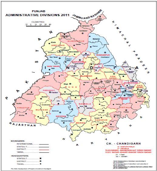
2 MAP OF PUNJAB1
3 1. STATE PROFILE General:- Punjab is situated in the northwest India. The Indian state borders the Pakistani province of Punjab to the west, Jammu and Kashmir to the north, Himachal Pradesh to the northeast, Chandigarh to the east, Haryana to the south and southeast and Rajasthan to the southwest. The total area of the state is 50,362 square kilometers. The population is 2,77,04,236 (Census, 2011). Punjab's capital is Chandigarh, which is administered separately as a Union Territory since it is also the capital of neighboring Haryana. Other major cities of Punjab include Mohali, Ludhiana, Amritsar, Patiala and Jalandhar. 1.2 Administrative Set-Up:- Punjab has twenty two districts each under the administrative control of a District Collector. The districts are subdivided into 79 Tehsils, which are under the administrative control of a Tehsildar. Each Tehsil consists of blocks which are total 143 in number. The blocks consist of revenue villages and the total number of revenue villages in the state is 12,278. Apart from these there are 22 Zila Parishads, 136 Municipal Committees and 22 Improvement Trusts looking after 143 towns and 14 cities of Punjab. Below Fig and Table gives the administrative subdivisions of Punjab. Geographical area, number of villages and blocks in different districts of Punjab
4
5 1.3 Geology:- The total geographical area of the state is 50,362 sq. kms. As per Census 2011, Punjab has a total population of 2,77,04,236 out of which 1,46,34,819 are males and 1,30,69,417 are females. It constitutes 2.29% of total population of India. Population density of Punjab is 550 persons per sq.km. Regions The area of Punjab can be divided into three regions which are the following: Malwa is a region of Punjab and parts of Haryana between the Sutlej and Yamuna rivers. People of Malwa are known for being great fighters, and warriors. The Malwa area makes up majority of the Punjab region consisting 11 districts. Cities such as Ludhiana, Patiala, Bhatinda and Mohali located in the Malwa region, Majha is a historical region of the Indian Punjab comprising the modern districts of Amritsar, Gurdaspur and Tarn Taran. It lies between two of the five great rivers of the Punjab: the Ravi and the Sutlej. Doaba is the region of Indian Punjab surrounded by the rivers Beas and Sutlej. The name "Doaba" literally translates to "land of two rivers" ("Do" two, "Ab" river; Punjabi). It is one of the most fertile regions of the world, and was the centre of the Green Revolution in India. To this day, it remains one of the largest per capita producers of wheat in the world. The biggest cities in Doaba are Jalandhar, Hoshiarpur, Adampur, Nawansher and Phagwara. 1.4 Socio Economic Profile 3 :- Punjab is unarguably one of the most wonderful states in India with regards to the climate. The state has fabulous weather throughout the year which is also conducive for the growth of a variety of crops. The state has seen a lot of ups and downs during the years of freedom struggle and has developed to be one of the strongest states in India with respect to the economical conditions. Some of the most influential and powerful leaders of the country have emerged from this state and the current Prime Minister of the country also hails from the state of Punjab. The state of Punjab is the highest producer of Wheat in the country and a huge percentage of the country's army is represented by the wonderful state of Punjab. The Population of Punjab according to the 2011 census stands at about 27 million, making it the 15th most populated state in India. The state is spread over an area of about sq. km. making it the 19th largest state in the country in terms of area. The density of population per sq. Km. is about 550 which is inevitable given the opportunities of growth and development in the state. The state has a growth rate of about 13% which is below the national average of 17%. The population of the state is rising considerably due to rapid efforts towards development and progress. The literacy rate in the state is about 73% a figure that has improved tremendously in the last few years due to the consistent efforts of the government. The sex ratio in Punjab leaves a lot to be desired as it lags behind the national average by a lot of points. The statistics in the Punjab Census 2011 reveal facts that can be instrumental in planning for a better development plan for the state.
6 Description 2011 Population 27,704,236 Population Growth Population Density/sq. km 550 Male 14,634,819 Female 13,069,417 Sex Ratio 893 Percentage of total Population 2.29% Literacy % Male Literacy 81.48% Female Literacy 71.34% Total Literate 18,988,611 Male Literate 10,626,788 Female Literate 8,361, Soils 4 :- There are many different classifications of soils of Punjab by different sources. The layman does not easily understand the soil taxonomy classification. What follows is the simple texture based soil classification on the basis of texture, climate, topography and denudation process. The soils of Punjab have been classified into the following major types: Flood Plain or Bet Soils Loamy Soils Sandy Soils Desert Soils Kandi Soils Sierozems Grey- Brown Podzolic & Forest Soils Sodic and Saline Soils 1.6 Physiography:- Physiography refers to the study of physical features of the area and their relationship with one another including the factors and processes responsible for the evolution of landforms. The state of Punjab forms a part of Indo-Gangetic alluvial plain and is composed of sediments of Shiwalik hills and Himalayas brought down and laid by the rivers of Indus system. The exact depth of the alluvium has not been ascertained, though it varies from a few metres to over 2000 metres. The state can be divided into the following major physiographic units:
7 a. Siwalik hills b. Piedmont plain c. Alluvial plain d. Sand dunes e. Flood plain f. Palaeochannels The Siwalik Hills in the north-east are steeply sloping. Numbers of choes originate in the Shiwalik zone and drain the excess storm water. The Shiwalik hills occupy nearly 2.6 per cent area of the state and cover sizeable area of Gurdaspur, Hoshiarpur, S.B.S. Nagar, Rupnagar and S.A.S Nagar districts of the state. The hills have dense to open scrub forest. The piedmont area forms a transitional zone between the Shiwalik hills and alluvial terraces. It is about 10 to 15 km wide and comprises of Gurdaspur, Hoshiarpur, S.B.S. Nagar, Rupnagar and S.A.S Nagar districts. The elevation of this zone varies from 300 to 375 m above MSL. The piedmont area is gently sloping to undulating and is dissected by number of seasonal rivulets (choes) which transport storm water with sediments from their catchment. The coarsest of these sediments are deposited in the form of alluvial fans at the foot hills and finer fractions are deposited aling the choes within the piedmont area. The sand dunes are low ridges along the present and old courses of rivers and choes. They are formed as a result of reworking of sand bar deposits of rivers. The deposits are sandy in texture and dominated by quartz and feldspar minerals. The sand dunes covered nearly 9.0 per cent area of the state during 1987, however, as a result of levelling and clearing by the farmers in the recent past, the area of sand dunes has been reduced to barely 0.56 per cent during The areas in and around the sand dunes are moderately sloping whereas interdunal areas are nearly level to gently sloping. The alluvial plain/terraces are the old flood plains of the rivers, the remnants of which lie above the level of the present river beds. They are separated from flood plains at their bases by broken chains of sand dunes and cliffs. The deposits of terraces vary with respect to texture, depth of carbonate leaching and translocation of other mobile soil constituents. Some parts of these terraces are affected by water logging and/or salinity and alkalinity. The unit occupies nearly 76.9 percent of the total geographical area of the state. Three major alluvial plains/ terraces are recognised in the state. They are popularity known as Uppar-Bari Doab covering most parts of Tarn Taran, Amritsar and Gurdaspur districts. Bist Doab covering area between Beas and Satluj rivers and Malwa plain, area south of river Satluj. The flood plains of Ravi, Beas, Satluj and Ghaggar rivers and many seasonal rivulets cover nearly 10.0 per cent area of the state. The flood plain soils are young and stratified without appreciable alteration of sediments. The continuous erosion cum deposition keeps the soils

8 young as time becomes a limiting factor for the consolidation of sediments into pedogenic horizons. The palaeochannels are believed to be the remanants of the old active channels. The origin of these channels may be due to the frequent changes in the courses of Ravi, Beas, Satluj and Ghaggar rivers and their tributaries, which became defunct and silted up. These areas occupy a low-lying topographic position on the landscape. 1.7 Land Utilization:- Land use/land cover information is essential input for rational land use planning and environmental conservation. The land use statistics in three major socio-cultural zones of Punjab is presented in the following Table:- Area (ha) under different land use/land covers categories in different socio-cultural zones of Punjab
9

10
11 1.8 Climate and Rainfall:- The climate of Punjab is mainly influenced by the Himalayas in the north and the Thar Desert in the south and south-west. The periodic circulation of the moist air masses from the south-east and north-western sectors decides the occurrence of two wet periods each followed by a dry period. The presence of Himalayas in the north greatly modifies the temperature. As the distance from the Himalayas increases the temperature also increases, whereas rainfall decreases. In general, summers are hot and winters are cool. The state experiences three distinct seasons, the hot season from April to June, the rainy season from July to September and the winter season extending from October to March. The highest temperature (between 44.2 and 44.7 C) in the state is recorded in the month of June and the lowest (between 0 and 2.2 C) in December. The mean annual rainfall is 705 mm, which varies from 1200 mm at Pathankot to less than 300 mm at Abohar, representing wettest and driest stations, respectively. The major part of the rainfall occurs between the months of July and September, and is essential for growing Kharif crops and subsequent sowing of rabi crops. Hence the climate of the state is dominantly semi-arid and monsoon type. The soil moisture regimes are udic, ustic and aridic and the soil temperature regime is mainly hyperthermic. Temperature: Day temperatures are more or less uniform over the plains except during winter and monsoon season. In general the night temperature is lower in higher altitudes except during the post monsoon when they are more or less uniform. June is the hottest month with mean maximum temperature of 410 C in plains and with 2 to 50 lower temperatures at elevated places. Highest temperature recorded in the plains is 450. January is the coldest month with mean minimum temperature for the state on a whole is 5.50C, varying from 40 to 50C in the west to 60 to 70 C in the east. Both maximum and minimum temperature rise from January till June. Rainfall: State receives about mm of average annual rainfall. 75% of which is received during monsoon months from July to Sept. July and August are rainiest months. Rainfall in the state varies from 26 cm in extreme southwest parts to 72 cm in extreme southern parts and varies from 42 cm in southern parts to 13.5 cm over northern parts. Districts north of Gurdaspur constitute the area of maximum rainfall and districts southwest of Ferozepur receive minimum amount of rainfall. These districts represent lowest and highest rainfall in the state.
12 2. DISASTER RISK PROFILE 5 The State of Punjab suffers mainly from two natural hazards, namely, flood and earthquakes, of which floods have quite a high frequency of occurrence, whereas earthquakes of M > 5.0 have a moderate frequency within and close to the boundary of the State. Theoretically risk is said to be the product of hazard and vulnerability of that region. In Disaster Management, risk is measured in terms of expected loss of human lives, loss of capital, property like agricultural land, roads, structures, livestock etc. Hazard is potentially a damaging physical event, phenomenon or human activity that may cause the loss of life or injury, property damage, social and economic disruption or environmental degradation. Hazards can include latent conditions that may represent future threats and can have different origins: natural (geological, hydro meteorological and biological) or induced by human processes (environmental degradation and technological hazards). Hazards can be single, sequential or combined in their origin and effects. Each hazard is characterized by its location, intensity, frequency and probability. Vulnerability is the internal weakness of a system from external threats and in disaster perspective it is the conditions determined by physical, social, economic, and environmental factors or processes, which increase the susceptibility of a community to the impact of hazards. It is the degree of loss (from 0 to 100 per cent) resulting from a potentially damaging phenomenon. It is the degree to which a person, system or unit is likely to experience harm due to exposure to perturbations or stresses. Risk is the probability of harmful consequences, or expected losses (deaths, injuries, property, livelihoods, economic activity disrupted or environment damaged) resulting from interactions between natural or human-induced hazards and vulnerable conditions. A hazard becomes a disaster only when it affects human settlements and causes loss of life and damage to property. In order to reduce the impact of such events through mitigation efforts, it is necessary to understand how such hazards become disasters. The extent of vulnerability of the area, people and property to a hazard or the probability of its occurrence defines the extent of risk. Vulnerability analysis and risk assessment therefore are essential forerunners for evolving appropriate preventive measures and mitigation strategies. The process of conducting a risk analysis is based on a review of both the technical features of hazards such as their location, intensity, frequency and probability; and also the analysis of the physical, social, economic and environmental dimensions of vulnerability and exposure. Punjab is vulnerable to 21 types of hazards out of 33 identified by the High Powered Committee (HPC) of Government of India into 5 sub-groups. In addition to hazards by HPC, state has high impact of Groundwater and Surface water Pollution, depletion of groundwater level and cancer epidemic which needs to be addressed as hazard.
13 DISASTERS IDENTIFIED BY THE HIGH POWERED COMMITTEE OF GOVERNMENT OF INDIA (1999) 2.1 Hydro-meteorological Disasters a. Flood:- A major part of geographical area of the state is prone to floods although substantial part has been protected through flood control measures. Nevertheless, the protected area also faces risk, although in reduced magnitude, because of possibility of flood in case of failure of protection works. The district wise damage risk tables show high to very high from flood to a large number of houses and medium risks to many houses in the protected area from the consideration of possibility of failure of flood control works in extreme floods. As per records, about 62,000
14 houses are damaged due to floods annually on an average. The maximum damage of houses was reported in floods of A gist of flood damage scenario in the state as per available record is shown in Table. Apart from the State Govt., Bhakra Beas Management Board is the focal organisation in-charge of management of flood related aspects in the state. Detailed study of flood problem of particular areas, drainage problem and systematic maintenance of embankments are some vital aspects for disaster mitigation in the state. Many flood control works including embankments have been constructed in the state. Possibility of failure of the works at vulnerable points is a major consideration for flood disaster mitigation. Also house constructions should follow the Guidelines and the settlement planning should be based on Land Use Zoning Guidelines. No. of villages/towns affected, human lives and Cattle lost due to Floods during the Rainy Season in Punjab
15 Source: Economic Advisor of Punjab Amongst all the natural disasters afflicting the State, floods are the most frequent and devastating. Almost 80% of the annual rainfall is concentrated over a short monsoon period of 3 months.

16 In Punjab, damages due to floods are caused mainly by the river Ravi, Sutlej and Ghaggar, which have a common delta where floodwaters intermingle, and, when in spate simultaneously, wreaks considerable havoc. The problem is further accentuated when flood synchronises with high tide. The silt deposited constantly by these rivers in the delta area raises the bed levels and the rivers often overflow their banks or break through new channels causing heavy damages. b. Water Logging:- The Water table is rising in South-western districts of the state due to limited or non-extraction of groundwater because of blackish/saline quality, which makes it unfit for domestic, irrigation and other purposes. This has caused water logging in some parts of this area. In the Nineteen Fifties, the sub-soil water level in the South Western districts, mainly in the Muktsar, Malout and Abohar tracts, was about 33 meters below ground level. After the construction of twin canals i.e.
17 Rajasthan Canal feeder and Sirhind Canal feeder, in addition to Abohar Branch and Bikaner Canal, the sub-soil water level started rising at the rate of 0.2 metre to 1.0 metre annually. The area has witnesses a rise in water level upto 22 meter in the last 25 years. The main reason of water logging is non-extraction of underground water, which is blackish/ saline. The topography of the entire area of Muktsar and Malout, which is saucer shape and impedes surface drainage system both natural and artificial, the constant seepage from the twin canals and return flow from canal irrigation, are some of the other contributory factors towards creating water logging problem. The Water table is rising in south-western Districts of the state due to limited or non-extraction of groundwater because of blackish/saline quality, which makes it unfit for domestic, irrigation and other purposes. This has caused waterlogging problem in Kahnuwan Bet Area in district Gurdaspur, Chamkaur Sahib and Sri Anandpur Sahib Block in district Ropar. c. Drought:- State of Punjab includes lack of potable water for residents and crop failure due to lack of water for irrigation. Secondary impacts include damage to the agriculture and tourism sectors of the economy. Punjab experienced drought due to inadequate rain in Monsoon. The State was experienced drought in 1978, 1979, 1985, 1987, 2002 and 2004, both in rural and urban areas. In 1987, a major drought was experienced in the State but in 2002, the intensity of the drought has made the situation much more acute and has broken the back of the farming community. The State Government declared all the 17 districts in the State as drought affected. The primary causes of drought include low rainfall or inadequate snow pack the preceding winter. However, other factors may also contribute to drought conditions including land degradation and an increase in water demand. An increase in water demand may be a result of increased population or industry, but can also result from water used for fire fighting. Technological failure of human-built water supply systems can also lead to drought like conditions, though this is often of a localized nature. The Intergovernmental Panel on Climate Change (IPCC, 2001) climate models incorporate scenarios of possible future states of the global climate. The most common scenarios are based on a range of socioeconomic assumptions (e.g. future global population and Gross Domestic Product). The models project global temperature increases ranging from 1.4 ºC to 5.8 ºC by 2100 (relative to 1990), accompanied by changes in precipitation and other aspects of the climate system. In British Columbia, the average annual temperature may increase by 1 ºC to 4 ºC, with
18 more dramatic effects in the northern portion of the province than in the southern. Even a seemingly minor increase in average annual temperature can have significant impacts on weather patterns, plant species distribution, and animal migrations, for example. These changes can impact tourism, agriculture, municipal and agricultural water supplies, forestry, and other industries. d. Desertification:- Desertification is a process whereby the productivity of the land declines because of deforestation, over-cultivation, drought, over-grazing, poor irrigation methods, salinization, soil erosion and changes in rainfall patterns. Desertification is a longterm process in terms of its development and impacts but its consequences are drought, famine and dying animals. A United Nations Development Programme (UNDP) report states that about 12% of Punjab state suffers from the threat of desertification. Today, India and Pakistan both face the threat of desertification in the semi-arid zone of Punjab. Land has been intensively cultivated under the Green Revolution at the expense of grazing and traditional fallow periods. The desertification of Punjab is proceeding (and will increase with climate change) due to the excessive use of fertilizers and improper irrigation techniques without proper long-term soil conservation strategy. e. Soil Erosion:- Soil erosion is the removal of the topsoil layer or soil particles by physical or human activities. This is a result of the absence of vegetative cover and moisture. Intensive cultivation, deforestation and destruction of the natural vegetation by grazing or other means will increase soil erosion. It is estimated that 3,000 hectares of cultivated land are lost to erosion in Punjab province annually. The Kandi tract in Rupnagar district of Punjab state has undulating topography, inadequate ground water, steep slopes, bare land surfaces and, thus, severe problems of soil erosion. Soil erosion can result in landslides, flash floods and the silting of water channels and dams downstream. Status of Soil Erosion: Punjab is facing very serious problem of soil erosion by water. It is serious menace in the Shivaliks and Kandi region, along the river courses, streams and choes and in the south western arid and hot region. It is more prevalent in Gurdaspur, Nawashehar, Hoshiarpur and Ropar districts of north-eastern of Punjab where water erosion by various choes and streams is much more and is aggravated by the loose structure and softness of rocks, steep slopes, deforestation overgrazing and various cultural and economic activities of man. In sub-mountain region of Punjab, runoff is one of the major modes of escape of rainwater received in the area.
19 Studies in the area have indicated that runoff during the monsoon period varies between 24 and 36 percent, whereas annual loss of rainwater varies between 26 and 42 per cent. As far as individual storms are concerned, the runoff varies from none to as high as 80 per cent. The peak runoff rates recorded in the area are sufficient to cause flash floods. The runoff carries along with it upper fertile soil rich in applied nutrients, thereby decreasing productivity of the soil. The whole Kandi region have been rendered infertile and dissected and are prone to flooding by hundreds of choes that transverse the districts of Hoshiarpur, Gurdaspur, Nawashehar and Ropar from Shiavilks to the flat alluvial plains. It covers nearly 11% area of the state. As per Central Water Commission (2003), 9140 sq km area in the state is prone to water erosion. 2.2 Geological Disasters a) Earthquake:- Based on tectonic features and records of past earthquakes, a seismic zoning map of India has been prepared by a committee of experts under the auspices of Bureau of Indian Standard (BIS Code: IS: 1893: Part I 2002). In this seismic zoning map, most of the area of Punjab State lies in Zone III and IV. However, northern boundary of Punjab State with Himachal Pradesh is in close proximity to Zone V. The Zone III and IV are broadly associated with a seismic intensity VII and VIII on MMI scale respectively. It may be mentioned that the seismic intensity VII on the MMI scale corresponds to horizontal ground acceleration range of cm / sec2 or an average acceleration of 67 cm / sec2 in any direction and the seismic intensity VIII on MMI scale corresponds to horizontal ground acceleration range of cm / sec2 or an average acceleration of 172 cm / sec2in any direction. The ground acceleration and hence seismic intensity of an earthquake at a place depends on the magnitude of an earthquake, distance from the focus, duration of earthquake, characteristics of underlying soil and its damping characteristics. Generally, the damage to the buildings founded on sandy soil will be higher than that in similar type of buildings having their foundation on hard bedrock. Also, the damage will be higher for higher magnitude and long duration earthquakes, less epicentral distance, soft soil conditions and areas with high liquefaction potential.

20 Source: BMPTC From the earthquake hazard map given in the above, it is seen that about 50 percent of the area of the state in the north, consisting of Amritsar, Gurdaspur, Hoshiarpur, Jalandhar, Kapurthala, Ludhiana, Patiala and Rup Nagar districts is liable to MSK Intensity VIII and about 45 percent could have Intensity VII. An earthquake of M 5.5 occurred in Kapurthala district in 1952 and much larger earthquakes of M 7.0 to 8.0 have occurred in Himachal Pradesh at about 50 to 60 km from the State boundary, which could cause moderate to heavy damage in the districts of Gurdaspur, Amritsar and Hoshiarpur. Earthquakes of M > 5.0 that are known to have occurred in and around the State are listed in the following table:-
21 Punjab is one of the richer states of the country. As such large majority of the housing is constructed under burnt bricks (placed in Category B) and only small percent are kucha with clay mud or unburnt brick walls (placed in Category A), as summarized below:- % Area of state in intensity VIII = 48.6 % Area of state in intensity VII = 45.6 Total housing units (2001 census) = 5,967,467 % of Category B units = 89.3 % of Category A units = 6.4 Now the Category A housing (built with clay walls or stone laid in mud mortar) are so weak that they would collapse completely in an Intensity VIII shock, and will be destroyed with partial collapse even in Intensity VII earthquake. On the other hand Category B (burnt brick) houses built using mud mortar will suffer severe damage with partial collapse under Intensity VIII, but only moderate damage if built in 1:6 cement-sand mortar. Under Intensity VII, Category B housing will suffer cracking, minor to wider, depending on the quality of mortar. Under collapsing condition of the houses, people and cattle can be buried and killed. For a feel of the Intensities it may be mentioned that Intensity VIII was reached in Latur earthquake of 1993 in which about 9000 human lives were lost due to the collapse of stone houses with heavy flat roofs; and Intensity VII occurred in the Jabalpur earthquake of History of Earthquakes in Punjab The state of Punjab hence falls in a region of moderate to high seismic hazard, as per the 2002 Bureau of Indian Standards (BIS) map. Historically, parts of this state have experienced seismic activity in the M range. Instrumentally recorded data on earthquakes shows that most of the area of Punjab State lies in a seismically active region which has been affected by moderate to great earthquakes in the past. The prominent amongst them are: (i) Kangra earthquake of 4th April 1905 (M: 8.0): At least 28,000 people were killed in the Kangra-Dharamsala region of Himachal Pradesh. Damage and casualties also occurred in adjoining parts of Punjab including in the cities of Amritsar, Lahore, Jalandhar, Ludhiana and Sialkot. (ii) Dharamshala earthquake of 26th April 1986: The epicenter was close to Kandi area of Punjab and due to this earthquake six people were reported killed, thirty injured and 85% of the houses were reported damaged in Dharmasala area. This earthquake was also followed by a number of aftershocks. (iii) Uttarkashi earthquake of 21st October 1991 (M: 6.8): Between 750 to 2000 people killed in the Gharwal region. It was also felt very strongly in Uttar Pradesh, Chandigarh, Delhi, Haryana and Punjab. Some minor damage was reported in Chandigarh and New Delhi.
22 (iv) Chamoli earthquake of 29th March 1999 (M: 6.5): The epicenter was Near Gopeshwar (Chamoli), Uttaranchal. 115 people killed in the Gharwal region. The quake was felt very strongly in Uttar Pradesh, Chandigarh, Delhi and Haryana. In Haryana, one person was killed in the city of Ambala and 2 at Nakodar in the neighbouring state of Punjab. Minor damage to buildings in New Delhi, most significantly in Patparganj. Minor damage also reported from Chandigarh. (v) Pakistan earthquake of 8th October 2005 (M: 7.6): A major earthquake struck the India- Pakistan border on the morning of 8 October It had a magnitude of Mw=7.6 and was felt strongly in much of Pakistan, northern India and eastern Afghanistan. The earthquake resulted in more than 80,000 deaths in northern Pakistan and adjoining parts of Jammu & Kashmir, India and is by far one of the deadliest in the sub-continent. At least 10 people also died in other parts of north India (including 2 in Punjab) and 4 in Afghanistan due to this earthquake. Tremors from the earthquake were felt more than a thousand kilometres away in the Indian states of Gujarat, Madhya Pradesh and Uttar Pradesh. (vi) Punjab earthquake of 14th March 2010 (M: 4.5): A light earthquake occurred in northern Punjab along the Punjab-Himachal Pradesh border on 14 March 2010 at 12:23 PM local time in India. It had a magnitude of Mb=4.5 and was felt over a wide area due to its depth. Besides the above noteworthy earthquakes, many other significant earthquakes from IMD catalogue occurred in the region bounded by latitude N and longitude E (covering Punjab and nearby areas) till date. Some of them could have been experienced in Punjab region. The occurrence of earthquakes in the region is attributed mainly to the chief tectonic features in Himalayas such as the Main Boundary Thrust (MBT), the Main Central Thrust (MCT) and Himalayan Frontal Thrust. These are locally termed as the Jwalamukhi Thrust, the Reasi Thrust, the Murree Thrust, the Panjal Thrust, the Zanskar Thrust etc. The other tectonic features of importance in the region are Kallar Kasar thrust, Salt Range thrust, Drang thrust, Ropar Fault and Sunder Nagar Fault. From the available geological and seismological evidence, it is seen that these faults have been active in the past. According to the theory of plate tectonics, the area lies near the boundary of Indian and Eurasian plates along which there is a wide zone of deformation due to cracking and splintering of the lithosphere and is characterized by single dominant direction of underthrusting. Geophysical data in and around Himalayas have shown that the Indian plate is moving North-North -Eastwards at a rate of about 5 cm. per year and colliding with Eurasian plate due to which stresses are accumulating in the region. The accumulated stress is occasionally released in the form of earthquakes along various segments of Himalayan arc.
23 Presently, there is no scientific technique available anywhere in the world to predict occurrence of earthquakes with reasonable degree of accuracy with regard to space, time and magnitude. It is, therefore suggested that appropriate steps may be taken to ensure that the dwellings and other structures in the region are designed and constructed as per guidelines laid down by Bureau of Indian Standards (BIS) to minimize the losses caused by earthquakes. The choice of seismic factor to be adopted for designing and engineering the structures depends on horizontal ground acceleration and various other factors including type of structures, the ground conditions and also importance of structures. For important and critical structures, site specific spectral studies have to be carried out before assessing the seismic design parameters. 2.3 Accidents a) Road Accidents:- The figures of road accidents indicate rising trend in Punjab. The figures are however not complete since each and every accident case is not reported at the police stations. Thus, the actual number or road accident cases may be still higher. Except for the observance of the Traffic Week in the first week of January every year in the State, there is very little regular and sustained campaigns to prevent and reduce the road accidents. Road Accidents in Punjab b) Rail Accident:- Source: Director General of Police Crime, Punjab Khanna Rail Disaster The Khanna rail disaster occurred on November 26, 1998 near Khanna on the Khanna-Ludhiana section of India's Northern Railway in Punjab, at 03:15 when the Calcutta-bound Jammu Tawi- Sealdah Express collided with six derailed coaches of the Amritsar-bound "Frontier Mail" which
24 were lying in its path. At least 212 were killed in total the trains were estimated to be carrying 2,500 passengers. The initial derailment was caused by a broken rail. Sarai Banjara Rail Disaster The Sarai Banjara rail disaster occurred on 2 December 2000, when a derailed freight train crossed onto the opposite track early in the morning in Punjab, India. A passenger train coming the other direction hit the freight train head on at speed, killing 46 people and injuring at least 150. Ladhowal rail disaster The Ladhowal rail disaster on 15 May 2003, was an flash fire which began at 4am on the Frontier Mail train service in India, and engulfed three carriages before it could be extinguished. 39 people lost their lives and another 15 were hospitalized with severe burns. The train service from Mumbai to Amritsar, had just passed the station at Ludhiana and was approaching Ladhowal, travelling at over 100km/h. Eyewitness A. D. Singh reported that he had seen the fire begin as a result of a dropped cigarette, whilst Safi Pitoliwali claims he saw electrical wiring in the toilet of the fourth carriage alight, but what ever the cause, the speed of the train combined with the open windows during the Indian summer to create an inferno, as air carried the fire back through three carriages in a massive burst of flame. When emergency services did arrive, there was no water available due to a local drought, so the wreckage had to be left to burn itself out. 2.4 Atmospheric:- There have been occasional incidents of thunderstorms, lightening, squall, gale and hailstorms resulting in damages of property, crops, livestock and human lives. Most important aspect for tacking this kind of disaster will be to ensure immediate first aid to the affected population and then to shift them to the nearest hospitals. In case of localized fire generally local people come to extend help to immediately control it. a) Hailstorm Hailstorms consist of precipitation in the form of balls or irregular lumps of ice formed when updrafts in thunderclouds carry raindrops into extremely cold areas of the atmosphere. Slight hailstorm is sparse usually small in size and often mixed with rain. Moderate hailstorm is abundant enough to whiten the ground. The heavy hailstorm includes at least a proportion of large stones. Punjab state often gets affected by moderate to heavy hailstorms. In the past such
25 hailstorms have often affected the standing crops, trees, vehicular traffic, telecommunication services etc. Hailstorms in Punjab Slight: Sparse, usually small in size and often mixed with rain. Moderate : Fall abundant enough to whiten the ground. Heavy: Includes at least a proportion of large stones. Hailstorms in Punjab b) Gale CRITERIA Strong: Wind Speed 75 Kmph. Source: - Indian Meterological Department, New Delhi. GALE in Punjab Source: - Indian Meterological Department, New Delhi.
26 c) Lightning Lightning in Punjab Source: - Indian Meterological Department, New Delhi. d) Squall CRITERIA Moderate: Surface Wind Speed (in gusts) upto 80 Kmph Severe : Surface Wind Speed (in gusts) more than 80 Kmph. SQUALL in Punjab Source: - Indian Meterological Department, New Delhi. e) Thunderstorm CRITERIA Moderate: Loud peals of thunder with frequent lightning flashes, moderate to heavy rains and maximum wind speed 29 to 74 Kmph. Severe: Continuous thunder and lightning, heavy rains and Maximum wind speed 75 Kmph.
27 Thunderstorm in Punjab Source: - Indian Meteorological Department, New Delhi. f) Heat Wave Climatic changes, decrease in tree cover, depletion of ground water resources and increase in day temperature especially in the months of May and June, have made majority of the districts of the state vulnerable to heat wave. As per the data available, temperature in this state during the month of May and June goes as high as about 45 degree centigrade. The heat wave condition in Punjab is becoming increasingly prominent and regular. However, the main risk due to heat wave is heat stroke. The main causal factor was identified as lack of awareness and not following certain does and don ts during heat wave conditions. Though
28 extensive awareness campaigns has reduced large number of fatalities, poor socio-economic conditions lack of enforcement and adoption of working conditions during the summer months and continuing weak facilities to treat heatstroke patients in most PHCs remain the main risks of heat wave. The State has had past histories of vulnerable to hail storms, thunder and lighting deaths or injury nearly every year. g) Cold wave When normal minimum temperature is less than 100 C, cold wave is said to be a condition when night temperature is 3-40C below normal. In such situation a severe cold wave is a condition in which night temperature is 50C or more below normal. When normal minimum temperature is more than 100 C, cold wave is said to be a condition when night temperature is 5-60C below normal. In such situation a severe cold wave is a condition in which night temperature is 70C or more below normal. Punjab has experienced cold waves and severe cold waves many times in the past. Cold wave on 02nd January 1990 is worth mention which took toll of 2 persons from Hosiarpur. Cold wave in Punjab Sl. No. Date/period Area Casualties 1 2 January 1990 Hoshiarpur 2 persons dead Source: - Indian Meteorological Department, New Delhi. h) Cyclones/Wind Storms So far as wind hazard is concerned, the design wind speed in almost the whole state is 47 m/s (169 km/h) which could only occasionally be reached in what is called Andhi. In such events, weakly built huts of thatch, sheets etc. and those with sloping roofs such as using thatch and tiles and A.C. sheet and corrugated Galvanized Iron (C.G.I.) sheet roofs which are not fully anchored and integrated will suffer damage. The damages occurring in Andhis is again of localised nature and does not result in a disaster to the State. But it will be useful to adopt the wind resistant construction guidelines and implement them for minimising wind damage. A moderate dust storm is called to a condition in which wind speed is between 39 to 74 kmph and horizontal visibility is up to 500 meters. A heavy dust storm is a condition when wind speed is 75 kmph and horizontal visibility is up to 50 meters. Punjab was badly hit by dust storms during the months from May to July of year Chandigarh was severely affected alongwith districts of Roopnagar, Ferozpur, Bathinda, Jalandhar, Muktasar, Patiala and Ludhiana. The dust storms occurred on 5 different dates and took a toll of 8 lives. Significant losses were caused to the houses, telecom services, trees, electric poles etc. apart from this Punjab experienced Gale
 Dust Storm Dust Storm in Punjab Source: - Indian Meterological Department, New Delhi.")
29 with wind speed 75 kmph on 12th May 1999 at Sangrur. In this gale 5 persons died and 7 others got injured. i) Dust Storm Dust Storm in Punjab Source: - Indian Meterological Department, New Delhi. PUNJAB Wind Hazard Map
30 2.5 Explosions and Leaks a) Chemical/Industrial disasters Over the years, there is substantial increase in industrial activities in the State. Many industries in the state store handle and process large volume of hazardous chemicals. This has caused potential threat to the employees, general public and environment in general. Industrial Disasters in Punjab Directorate of Factories, Punjab The industries, which are handling hazardous chemicals, are known as Major Accident Hazard (MAH) units. Many technological accidents have occurred in the state as well as in the country damaging lives and properties. Some areas in the state have been identified having cluster of industries handling hazardous chemicals and pose chemical and industrial disaster. 2.6 Fire a) Structure Fire A structure fire occurs in residential, commercial, or industrial buildings or structures. Fires can be ignited by a number of causes, such as faulty electrical wiring, cooking and heating equipment, and cigarettes. In some cases, fires may also be ignited intentionally. Structure fires are a reality within any Electoral Area in the State of Punjab and have the capacity to spread quickly to adjoining structures. b) Crop Fire Punjab occupies less than two percent of the area of the country, and yet it produces about twothirds of the food grains in India. Wheat and rice are the two most commonly grown food crops. Farmers use fire to clear fields and get them ready for new plantings. Crop residues become a soil-fertilizing ash, and burning destroys some crop pests. Although the fires are not necessarily immediately hazardous, such widespread burning can have a strong impact on weather, climate, human health, and natural resources. A plume of haze flows southeastward, along the path of the Ganges River, which is hidden from view. Although some of the haze is probably smoke from the fires, urban pollution is a major problem in this part of India. Several large cities are found here, including Delhi, India, where
31 soot from diesel cars is a major (and still increasing) source of air pollution. Other images of the haze can be found in a related Natural Hazards event, Haze along the Himalaya. 3. INSTITUTIONAL SETUP State Disaster Management Authority As per clause b of sub-section (2) of Section 14 of the Disaster Management Act. 2005, the Punjab Disaster Management Authority under the chairperson of the Honourable Chief minister was constituted on 22nd/24th February, 2006 with the following persons as member of the SDMA: State Disaster Management Authority The State Disaster Management Authority (SDMA) has the mandate to lay down the state policies and approval of State Disaster Management Plan, with the assistance of SEC. As stated in the Disaster Management Act 2005, the State DM Authority has the following roles and responsibilities: 1. Lay down the State disaster management policy 2. Approve the State Plan in accordance with the guidelines laid down by the National Authority. 3. Lay down guidelines to be followed by the departments of the State Government for the purpose of coordination and integration measures for prevention of disasters and mitigation in their development plans and projects and provide necessary technical assistance therefore; 4. Coordinate the implementation of State Plan at State and District level 5. Recommend provision of funds for mitigation and preparedness measures 6. Review the development plans of different departments of the State and ensure that prevention and mitigation measures like earthquake resistance structures are built at least for life line structures. 7. Review the measures being taken for mitigation, capacity building and preparedness by the departments of the State Government and issue such guidelines as may be necessary.

32 3.2 The State Executive Committee (SEC) As per sub-section (1) of section 20 of the Disaster Management Act, 2005, the State Executive Committee under the chairperson of Chief Secretary was constituted by the Government of Punjab on 22nd/24th February, 2006 with the following persons as member of the committee: State Executive Committee As per the Disaster Management Act 2005, the State Executive Committee may discharge following functions: 1. Coordinate and monitor the implementation of the National Policy, the National Plan and State plan. 2. Examine the vulnerability of different parts of the State to different forms of disasters and specify measures to be taken for their prevention or mitigation. 3. Preparation of State disaster management plans. 4. Monitor the implementation of State Disaster Management Plan (SDMP) and Crisis Management Plan (CMP) prepared by the line departments of the State Government and District Authorities. 5. Monitor the implementation of the guidelines laid down by the State Authority for integrating the measures for prevention of disasters and mitigation by the departments in their development plans and projects. 6. Evaluate preparedness at all government or non-governmental levels to responds to any threatening disaster situation or disaster and give directions, where necessary, for enhancing such preparedness. 7. Coordinate response in the event of any threatening disaster situation or disaster; 8. Give directions to line Departments of the government of the state or any other authority or body in the State regarding actions to be taken in response to any threatening disaster situation; 9. Promote general education, awareness and community training and to conduct regular Mock drills to test the plan in regard to the forms of disasters to which different parts of the State are vulnerable and the measures that may be taken by such community to prevent the disaster, mitigate and respond to such disaster; 10.Advise, assist and coordinate the activities of the Departments of the Government of the State, District Authorities statutory bodies and other governmental and non-governmental organizations engaged in disaster management.;

33 11. Provide necessary technical assistance or give advice to District Authorities an local authorities for carrying out their functions effectively; 12. Advise the State Government regarding all financial matters in relation to disaster management. 3.3 Technical Committee(s) Under sub-section (1) of Section 21 of the Disaster Management Act, 2005, the SEC will constitute the Technical Committee (s) for efficient discharge of its functions. The Technical Committee(s) will be appointed by the SEC. It will comprise disaster management experts, professionals and NGO field practitioners. They will be responsible for ensuring community participation in the disaster management activities. They will also advise the SEC on implementation of activities at State level. 3.4 State Crisis Management Group The State Crisis Management Group s function includes reviewing every year contingency plans formulated by various Ministries/Departments/ Organizations in their respective sectors. The other functions include: 1. To review measures required dealing with natural disaster. 2. Coordinate activities of state Governments and districts in relation to disaster preparedness and relief 3. To obtain information from the nodal officers on measures relating to the above.
34 3.5 State Working Groups A couple of working groups are constituted in state level in line with the national set up. These working groups are given with particular responsibilities and they are the core group of such functions. Besides, there is an Emergency operation Centre at the state level to coordinate and perform disaster management activities in a disaster situation as well as in the preparatory stage. 3.6 State Disaster Response Team It is proposed to raise a State disaster response team to be stationed at central location so that these team along with resources can reach the site of disaster in shortest possible time. This team will be under the administrative control of Director, DM and operational control of Department of Civil Defence and Home Guards. On the lines of NDRF, they will be imparted trainings in Medical First Responders, Flood Control, Search and Rescue etc. During peace times, they will assist in imparting trainings to general public. The manpower to be either recruited afresh or taken on deputation with the Department of Civil Defence from amongst the newly recruited constables of Punjab Police. PS Home has been requested to confirm if the second option is possible. Decision in this matter may kindly be taken. 3.7 Civil Defence The Civil Defence Policy of the GOI until 1962 was confined to making the states and UTs conscious of the need of civil protection measures and to keep in readiness civil protection plans for major cities and towns under the Emergency Relief Organization (ERO) scheme. The Civil Defence Organization is raised only in such areas and zones which are considered vulnerable to enemy attacks. During times of war and emergencies, the Civil Defence organisation has the vital role of guarding the hinterland, supporting the armed forces, mobilizing the citizens and helping civil administration for saving life and property, minimizing damage, maintaining continuity in production centres and raising public morale. The concept of Civil Defence over the years has shifted from management of damage against conventional weapons to also include threat perceptions against nuclear weapons, biological and chemical warfare and environmental disasters. 3.8 Fire Services Fire services are mandate of the Municiapal Bodies as estimated in item 7 of Schedule 12 under Article 243W of the constitution. The structure across is not uniform. Presently Fire prevention and Fire Fighting Services are organized by the concerned States and UTs. Ministry of Home Affairs, Govt. of India, renders technical advice to the States and UTs and Central Ministries on Fire Protection, Fire Prevention and Fire Legislation. Fire Services in Punjab is under the Municipal Corporations. 3.9 Home Guard

35 The role of Home Guard is to serve as an auxiliary to the police in the maintenance of law and order, internal security and help the community in any kind of emergency such as air-raids, fire, cyclone, earthquake, epidemic, etc. They are also expected to help the police in maintenance of communal harmony, assist the administration in protecting weaker sections, participate in socioeconomic and welfare activities and perform Civil Defence duties. Border Wing, Home Guard serves as an auxiliary to the Border Security Force. Punjab has 6 battalions of Border Wing Home Guards for preventing infiltration on the international border District Disaster Management Authority The District Disaster Management Authority (DDMA) will act as the district planning; coordinating and monitoring body in accordance with the guidelines laid down by the State Authority. As per Section 25 of the DM Act 05, A DDMA for every district in the State of Punjab has also been constituted, consisting of the following members:
 District level Disaster Management Advisory Committee(s) will be appointed by the District Disaster Management Authority to take advice on")
36 District Disaster Management Authority 3.11 District Disaster Management Advisory Committee (s) District level Disaster Management Advisory Committee(s) will be appointed by the District Disaster Management Authority to take advice on various subject specific fields within the overall context of disaster management. The committee will comprise disaster management experts, which may from government departments, research institutes or NGO s District Emergency Operation Centre The District Emergency Operation Centre (DEOC) will be hub of all the activities related with disaster response in the District. It will coordinate and communicate upward and down ward communication with regard to emergency response Tehsil/sub Tehsil/Block Disaster Management Committee Subject to the directions of the District Authority, the Tehsil/Sub Tehsil/block disaster management committee will be responsible for the development and implementation of block level disaster management plans Gram Panchayat/Village Disaster Management Committee Subject to the directions of the District Authority, the Gram Panchayat Disaster Management committees will be responsible for the development and implementation of GP level disaster management plans. The response plan has been subdivided into the following sections a) Response Management Arrangements b) State Disaster Response Plan c) Emergency Support Functions
A Presentation By: Dr. G. M. Dar Centre for Disaster Management & Env. Studies, J&K IMPA, Srinagar
 A Presentation By: Dr. G. M. Dar Centre for Disaster Management & Env. Studies, J&K IMPA, Srinagar Introduction Disaster: Sudden or great misfortune. A catastrophe, a calamitous event. Hazards are a natural
MINISTRY OF ROAD TRANSPORT AND HIGHWAYS Through Punjab PWD B&R PROJECT REPORT
 MINISTRY OF ROAD TRANSPORT AND HIGHWAYS Through Punjab PWD B&R CONSULTANCY SERVICES FOR PREPARATION OF FEASIBILITY SURVEY, DETAILED PROJECT REPORT OF EXISTING TWO LANE PLUS SHOULDER TO (4LANING OF TALWANDI
3. HYDROMETEROLOGY. 3.1 Introduction. 3.2 Hydro-meteorological Aspect. 3.3 Rain Gauge Stations
 3. HYDROMETEROLOGY 3.1 Introduction Hydrometeorology is a branch of meteorology and hydrology that studies the transfer of water and energy between the land surface and the lower atmosphere. Detailed hydrological
UNIT 11 SOUTH ASIA SG 1 - PHYSICAL GEOGRAPHY & THE ENVIRONMENT
 UNIT 11 SOUTH ASIA SG 1 - PHYSICAL GEOGRAPHY & THE ENVIRONMENT I. PHYSICAL GEOGRAPHY TAKE OUT YOUR PHYSICAL MAP OF SOUTH ASIA A. The Himalayan Mountains form the northern boundary of the region (color
Fukien Secondary School Monthly Vocabulary/Expression List for EMI Subjects Secondary Two. Subject: Geography
 Focus: General Specific : Section Two : Unit One 1 Landslide 2 Downslope movement 3 Rock 4 Soil 5 Gravity 6 Natural hazard 7 Rainwater 8 Friction 9 Hilly relief 10 Unstable 11 Season 12 Saturated 13 Construction
MODELLING FROST RISK IN APPLE TREE, IRAN. Mohammad Rahimi
 WMO Regional Seminar on strategic Capacity Development of National Meteorological and Hydrological Services in RA II (Opportunity and Challenges in 21th century) Tashkent, Uzbekistan, 3-4 December 2008
Report on Disaster statistics of Nepal
 Report on Disaster statistics of Nepal Submitted by Altaf Rehman Submitted to Dr. Naveed Ahmed University of engineering and technology Peshawar Assignment 1 Section A Registration id 14PWCIV456 Page 1
Flash flood disaster in Bayangol district, Ulaanbaatar
 Flash flood disaster in Bayangol district, Ulaanbaatar Advanced Training Workshop on Reservoir Sedimentation Management 10-16 October 2007. IRTCES, Beijing China Janchivdorj.L, Institute of Geoecology,MAS
SEISMIC RISK ASSESSMENT IN ARMENIA
 SEISMIC RISK ASSESSMENT IN ARMENIA Hovhannes Khangeldyan Head of National Crisis Management Center Rescue Service Ministry of Emergency Situations of the Republic of Armenia Tokyo, 2016 ARMENIA: GEOGRAPHICAL
Geography Class XI Fundamentals of Physical Geography Section A Total Periods : 140 Total Marks : 70. Periods Topic Subject Matter Geographical Skills
 Geography Class XI Fundamentals of Physical Geography Section A Total Periods : 140 Total Marks : 70 Sr. No. 01 Periods Topic Subject Matter Geographical Skills Nature and Scope Definition, nature, i)
Disaster RISK Management : Bhutanese Scenario
 Disaster RISK Management : Bhutanese Scenario Expert Group Meeting (EGM) on Geo-referenced Information Systems for Disaster Risk Management (Geo-DRM) and sustaining the Community of Practice (COP), Bangkok,
RISK OF PRINCIPAL DISASTERS IN INDIA AND IMPACTS OF DISASTERS ON ECONOMIC DEVELOPMENT
 RISK OF PRINCIPAL DISASTERS IN INDIA AND IMPACTS OF DISASTERS ON ECONOMIC DEVELOPMENT At the Himachal Pradesh Institute of Public Administration Shimla 05. 05.2012 Improve Disaster Management with the
Workshop on Drought and Extreme Temperatures: Preparedness and Management for Sustainable Agriculture, Forestry and Fishery
 Workshop on Drought and Extreme Temperatures: Preparedness and Management for Sustainable Agriculture, Forestry and Fishery 16-17 Feb.2009, Beijing, China Modeling Apple Tree Bud burst time and frost risk
Earthquakes. These icons indicate that teacher s notes or useful web addresses are available in the Notes Page.
 Earthquakes These icons indicate that teacher s notes or useful web addresses are available in the Notes Page. This icon indicates the slide contains activities created in Flash. These activities are not
Disaster Management and Spatial Data An Experience of Sri Lanka for Joint project team meeting 2012
 Disaster Management and Spatial Data An Experience of Sri Lanka for Joint project team meeting 2012 1 by Padma Kumara Withana Provincial Surveyor General Uva Province 2 Out line ü Introduction ü Natural
SIGNIFICANT EVENTS Severe Storms November 1994 January 1996 August 1998 and May 2000 March 2002 May 2002 Champaign County
 SIGNIFICANT EVENTS Severe Storms November 1994 On Nov. 1, 1994, high winds gusted over 60 mph at times across the northwest third of Ohio. The highest measured wind gust was 63 mph at Columbus Grove (Putnam).
3/3/2013. The hydro cycle water returns from the sea. All "toilet to tap." Introduction to Environmental Geology, 5e
 Introduction to Environmental Geology, 5e Running Water: summary in haiku form Edward A. Keller Chapter 9 Rivers and Flooding Lecture Presentation prepared by X. Mara Chen, Salisbury University The hydro
Flood hazard mapping in Urban Council limit, Vavuniya District, Sri Lanka- A GIS approach
 International Research Journal of Environment Sciences E-ISSN 2319 1414 Flood hazard mapping in Urban Council limit, Vavuniya District, Sri Lanka- A GIS approach Abstract M.S.R. Akther* and G. Tharani
HAZARD DESCRIPTION... 1 LOCATION... 1 EXTENT... 1 HISTORICAL OCCURRENCES...
 WINTER STORM HAZARD DESCRIPTION... 1 LOCATION... 1 EXTENT... 1 HISTORICAL OCCURRENCES... 3 SIGNIFICANT PAST EVENTS... 4 PROBABILITY OF FUTURE EVENTS... 5 VULNERABILITY AND IMPACT... 5 Hazard Description
LECTURE #14: Extreme Heat & Desertification
 GEOL 0820 Ramsey Natural Disasters Spring, 2018 LECTURE #14: Extreme Heat & Desertification Date: 27 February 2018 (lecturer: Dr. Shawn Wright) I. Start of Part 2 of the Course weather-related disasters
DROUGHT RISK EVALUATION USING REMOTE SENSING AND GIS : A CASE STUDY IN LOP BURI PROVINCE
 DROUGHT RISK EVALUATION USING REMOTE SENSING AND GIS : A CASE STUDY IN LOP BURI PROVINCE K. Prathumchai, Kiyoshi Honda, Kaew Nualchawee Asian Centre for Research on Remote Sensing STAR Program, Asian Institute
West Carroll Parish Hazard Mitigation Plan Update Public Meeting. August 25, 2015 Oak Grove, LA
 West Carroll Parish Hazard Mitigation Plan Update Public Meeting August 25, 2015 Oak Grove, LA Agenda Hazard Mitigation Planning Process SDMI Staff Risk Assessment SDMI Staff Update on Previous/Current
5.2. IDENTIFICATION OF NATURAL HAZARDS OF CONCERN
 5.2. IDENTIFICATION OF NATURAL HAZARDS OF CONCERN To provide a strong foundation for mitigation strategies considered in Sections 6 and 9, County considered a full range of natural hazards that could impact
Multi-Jurisdictional Hazard Mitigation Plan. Table C.10 The Richter Scale. Descriptor Richter Magnitude Earthquake Effects
 Geologic Hazards Earthquake Earthquakes are very rare in Pennsylvania and have caused little damage, with no reported injuries or causalities. Earthquakes that do occur in Pennsylvania happen deep within
GENERAL. CHAPTER 1 BACKGROUND AND PURPOSE OF THE GUIDELINES Background of the Guidelines Purpose of the Guidelines...
 GENERAL CHAPTER 1 BACKGROUND AND PURPOSE OF THE GUIDELINES... 1 1.1 Background of the Guidelines... 1 1.2 Purpose of the Guidelines... 3 CHAPTER 2 APPLICATION OF THE GUIDELINES... 3 2.1 Potential Users
Disaster Risk Assessment: Opportunities for GIS and data management with Open DRI
 Disaster Risk Assessment: Opportunities for GIS and data management with Open DRI Jacob Opadeyi Department of Geomatics Engineering and Land Management, The University of the West Indies, St. Augustine,
Kentucky Weather Hazards: What is Your Risk?
 Kentucky Weather Hazards: What is Your Risk? Stuart A. Foster State Climatologist for Kentucky 2010 Kentucky Weather Conference Bowling Green, Kentucky January 16, 2010 Perspectives on Kentucky s Climate
Chapter 2 Planet Earth
 Chapter 2 Planet Earth Section Notes Earth and the Sun s Energy Water on Earth The Land Close-up The Water Cycle World Almanac Major Eruptions in the Ring of Fire Quick Facts Chapter 2 Visual Summary Video
every continent has an extensive dry region! " deserts are as much as 1/3 of Earth s surface!
 deserts! deserts! every continent has an extensive dry region! " deserts are as much as 1/3 of Earth s surface! Hollywood portrayal of vast stretches of sand dune! " Sahara has only 10% covered by sand!
By Lillian Ntshwarisang Department of Meteorological Services Phone:
 By Lillian Ntshwarisang Department of Meteorological Services Phone: +267 3612200 Email: lntshwarisang@gov.bw/ lntshwarisang@gmail.com Introduction Mandate of DMS Function of the Department Services to
INDIANA ACADEMIC STANDARDS FOR SOCIAL STUDIES, WORLD GEOGRAPHY. PAGE(S) WHERE TAUGHT (If submission is not a book, cite appropriate location(s))
 WHERE TAUGHT (If submission is not a book, cite appropriate location(s))") Prentice Hall: The Cultural Landscape, An Introduction to Human Geography 2002 Indiana Academic Standards for Social Studies, World Geography (Grades 9-12) STANDARD 1: THE WORLD IN SPATIAL TERMS Students
Prentice Hall: The Cultural Landscape, An Introduction to Human Geography 2002 Indiana Academic Standards for Social Studies, World Geography (Grades 9-12) STANDARD 1: THE WORLD IN SPATIAL TERMS Students
Earthquake Disaster Management in India
 Earthquake Disaster Management in India Akshay B. Ahlawat JRF in Geography Abstract: The fact is that natural disasters are always unexpected events which affect human life as well as nature itself. Earthquakes
5.2 IDENTIFICATION OF HAZARDS OF CONCERN
 5.2 IDENTIFICATION OF HAZARDS OF CONCERN 2016 HMP Update Changes The 2011 HMP hazard identification was presented in Section 3. For the 2016 HMP update, the hazard identification is presented in subsection
Term Knowledge Using and applying Grade Criteria Autumn 1 Assessment window October Natural hazards pose major risks to people and property.
 Assessment Schedule Year 9 2015/6 Term Knowledge Using and applying Grade Criteria Autumn 1 Assessment window October 2015 3.1.1.2 Tectonic Natural hazards pose major risks to people and property. Definition
Report. Developing a course component on disaster management
 Report Developing a course component on disaster management By Chira Prangkio Tawee Chaipimonplin Department of Geography, Faculty of Social Sciences, Chiang Mai University Thailand Presented at Indian
Country Report Nepal Geospatial Data Sharing Initiatives of Survey Department Supporting Disaster Management
 Third JPTM Step 2 for Sentinel Asia 6-8 July, 2010 Manila, The Philippines Country Report Nepal Geospatial Data Sharing Initiatives of Survey Department Supporting Disaster Management Durgendra M Kayastha
ABSTRACT. 2. Location : 31 o 04'16'' to 32 o 31'27'' North Latitudes and 74 o 30'38'' to 76 o 08'45'' East Longitudes
 ABSTRACT 1. Surveyed Area : Prioritization of Microwatersheds of Beas Catchment (1B1) of Districts-Amritsar, Firozpur, Gurdaspur, Hoshiarpur, Jalandhar, Kapurthala, Tarntaran, Punjab State and Districts-
OUR COUNTRY INDIA LOCATIONAL SETTING
 7 India is a country of vast geographical expanse. In the north, it is bound by the lofty Himalayas. The Arabian Sea in the west, the Bay of Bengal in the east and the Indian Ocean in the south, wash the
Natural hazards in Glenorchy Summary Report May 2010
 Natural hazards in Glenorchy Summary Report May 2010 Contents Glenorchy s hazardscape Environment setting Flood hazard Earthquakes and seismic hazards Hazards Mass movement Summary Glossary Introduction
5.2 IDENTIFICATION OF HAZARDS OF CONCERN
 5.2 IDENTIFICATION OF HAZARDS OF CONCERN 2015 HMP Update Changes The 2010 HMP hazard identification was presented in Section 6. For the 2015 HMP update, the hazard identification is presented in subsection
Impact of Cyclone Nargis
 Lessons Learnt from Nargis Recovery for the Next Disaster International Recovery Forum (2011) 12, JAN 2011, Kobe, Japan Home for over 100 national races. Profile of Myanmar The 2 nd largest country in
DISASTERS IN MONGOLIA
 DISASTERS IN MONGOLIA ADRC Visiting Researcher Ms. Sh.Altanchimeg Kobe, 0Japan March, 2007 Mongolia is located in Asia, between China and Russia 1 1 Territory: 1,564,619 sq. km Population : 2,500,000.
Chapter 21 Southwest Asia: Harsh & Arid Lands
 Name Hour Chapter 21 Southwest Asia: Harsh & Arid Lands Essential Question: How has the physical geography of Asia influenced the development of these regions (i.e. history, population distribution, &
Assumption Parish Hazard Mitigation Plan Update Public Meeting. September 1, 2015 Napoleonville, LA
 Assumption Parish Hazard Mitigation Plan Update Public Meeting September 1, 2015 Napoleonville, LA Agenda Hazard Mitigation Planning Process SDMI Staff Risk Assessment SDMI Staff Update on Previous/Current
Use of Climate information in Disaster Risk Management in Zimbabwe
 Use of Climate information in Disaster Risk Management in Zimbabwe WMO Regional Technical Meeting & User/CONOPS Workshop, 28 th October 2015 Lameck Betera Department of Civil Protection Institutional Arrangements
They include earthquakes, volcanic eruptions, floods, landslides, and other processes and occurrences. They are included in the broader concept of.
 They include earthquakes, volcanic eruptions, floods, landslides, and other processes and occurrences. They are included in the broader concept of. In general, natural processes are labeled hazardous only
Disaster Risk Management in India. Kamal Kishore New Delhi, 27 October 2016
 Disaster Risk Management in India Kamal Kishore New Delhi, 27 October 2016 Hazard, Exposure and Vulnerability Disaster Prevention Mitigation Hurricane Matthew: Cuba & Haiti Emergency Response Coordination
TABLE OF CONTENTS LIST OF TABLES. Page
 TABLE OF CONTENTS Page 11.0 EFFECTS OF THE ENVIRONMENT ON THE PROJECT... 11-1 11.1 Weather Conditions... 11-1 11.2 Flooding... 11-2 11.3 Forest Fires... 11-2 11.4 Permafrost and Subsidence Risk... 11-3
Geologic Hazards. Montour County Multi-jurisdictional. General. Earthquake
 Geologic Hazards General s are very rare in Pennsylvania and have caused little damage with no reported injuries or causalities. s that do occur in Pennsylvania happen deep within the Earth s crust. This
International Journal of Modern Trends in Engineering and Research e-issn No.: , Date: April, 2016
 International Journal of Modern Trends in Engineering and Research www.ijmter.com e-issn No.:2349-9745, Date: 28-30 April, 2016 Landslide Hazard Management Maps for Settlements in Yelwandi River Basin,
Which map shows the stream drainage pattern that most likely formed on the surface of this volcano? A) B)
 B)") 1. When snow cover on the land melts, the water will most likely become surface runoff if the land surface is A) frozen B) porous C) grass covered D) unconsolidated gravel Base your answers to questions
1. When snow cover on the land melts, the water will most likely become surface runoff if the land surface is A) frozen B) porous C) grass covered D) unconsolidated gravel Base your answers to questions
STEUBEN COUNTY, NEW YORK. Hazard Analysis Report
 STEUBEN COUNTY, NEW YORK Hazard Analysis Report Prepared by: April 1, 2014 Background On April 1, 2014 the Steuben County Office of Emergency Management conducted a hazard analysis using the automated
Land subsidence due to groundwater withdrawal in Hanoi, Vietnam
 Land Subsidence (Proceedings of the Fifth International Symposium on Land Subsidence, The Hague, October 1995). 1AHS Publ. no. 234, 1995. 55 Land subsidence due to groundwater withdrawal in Hanoi, Vietnam
W I N T E R STORM HAZARD DESCRIPTION
 W I N T E R STORM HAZARD DESCRIPTION... 1 LOCATION... 2 EXTENT... 2 HISTORICAL OCCURRENCES... 4 SIGNIFICANT PAST EVENTS... 4 PROBABILITY OF FUTURE EVENTS... 5 VULNERABILITY AND IMPACT... 5 HAZARD DESCRIPTION
Your web browser (Safari 7) is out of date. For more security, comfort and the best experience on this site: Update your browser Ignore
 is out of date. For more security, comfort and the best experience on this site: Update your browser Ignore") Your web browser (Safari 7) is out of date. For more security, comfort and the best experience on this site: Update your browser Ignore ALLU VIAL FAN colluvial fan, debris cone For the complete encyclopedic
Your web browser (Safari 7) is out of date. For more security, comfort and the best experience on this site: Update your browser Ignore ALLU VIAL FAN colluvial fan, debris cone For the complete encyclopedic
Summary and Conclusions
 241 Chapter 10 Summary and Conclusions Kerala is situated in the southern tip of India between 8 15 N and 12 50 N latitude and 74 50 E and 77 30 E longitude. It is popularly known as Gods own country.
This table connects the content provided by Education Perfect to the NSW Syllabus.
 Education Perfect Geography provides teachers with a wide range of quality, engaging and innovative content to drive positive student learning outcomes. Designed by teachers and written by our in-house
WINTER STORM Annex II
 WINTER STORM Annex II I. PURPOSE A. This annex has been prepared to ensure a coordinated response by state agencies to requests from local jurisdictions to reduce potential loss of life and to ensure essential
5th social studies geography (5thsocstud_geography)
") Name: Date: 1. Many of the Native Americans who lived on the Great Plains were nomadic people. Why did they move from place to place? A. They were finding new areas to mine. B. They were looking for fertile
Name: Date: 1. Many of the Native Americans who lived on the Great Plains were nomadic people. Why did they move from place to place? A. They were finding new areas to mine. B. They were looking for fertile
Debris flow: categories, characteristics, hazard assessment, mitigation measures. Hariklia D. SKILODIMOU, George D. BATHRELLOS
 Debris flow: categories, characteristics, hazard assessment, mitigation measures Hariklia D. SKILODIMOU, George D. BATHRELLOS Natural hazards: physical phenomena, active in geological time capable of producing
Report for Area Drainage Studies for 1320 MW (2x660 MW) THERMAL POWER PROJECT AT MIRZAPUR, U.P.
 THERMAL POWER PROJECT AT MIRZAPUR, U.P.") Report for Area Drainage Studies for 1320 MW (2x660 MW) THERMAL POWER PROJECT AT MIRZAPUR, U.P. 1. Introduction M/s Welspun Energy Uttar Pradesh Ltd. (WEUPL) is putting up 1320 MW (2 x 660 MW) coal fired
Report for Area Drainage Studies for 1320 MW (2x660 MW) THERMAL POWER PROJECT AT MIRZAPUR, U.P. 1. Introduction M/s Welspun Energy Uttar Pradesh Ltd. (WEUPL) is putting up 1320 MW (2 x 660 MW) coal fired
Physical Geography: Patterns, Processes, and Interactions, Grade 11, University/College Expectations
 Geographic Foundations: Space and Systems SSV.01 explain major theories of the origin and internal structure of the earth; Page 1 SSV.02 demonstrate an understanding of the principal features of the earth
Managing Floods at Boscastle. Learning Objective: Examine the benefits of managing floods
 Managing Floods at Boscastle Learning Objective: Examine the benefits of managing floods Learning Outcomes: Describe how Boscastle has been affected by flooding Explain strategies to reduce the risk Evaluate
World Geography. WG.1.1 Explain Earth s grid system and be able to locate places using degrees of latitude and longitude.
 Standard 1: The World in Spatial Terms Students will use maps, globes, atlases, and grid-referenced technologies, such as remote sensing, Geographic Information Systems (GIS), and Global Positioning Systems
HAZUS-MH: Earthquake Event Report
 HAZUS-MH: Earthquake Event Report Region Name: El Paso County Earthquake Scenario: El Paso County Random EQ Print Date: February 08, 2006 Disclaimer: The estimates of social and economic impacts contained
Unit 2 Text Worksheet # 2
 Unit 2 Text Worksheet # 2 Read Pages 74-77 1. Using fig. 5.1 on page 75 identify: Climatic Region the most widespread climatic region in the low latitudes two climatic subregions with dry conditions for
Investigation of the Arizona Severe Weather Event of August 8 th, 1997
 Investigation of the Arizona Severe Weather Event of August 8 th, 1997 Tim Hollfelder May 10 th, 2006 Abstract Synoptic scale forcings were very weak for these thunderstorms on August 7-8, 1997 over the
DROUGHT ASSESSMENT USING SATELLITE DERIVED METEOROLOGICAL PARAMETERS AND NDVI IN POTOHAR REGION
 DROUGHT ASSESSMENT USING SATELLITE DERIVED METEOROLOGICAL PARAMETERS AND NDVI IN POTOHAR REGION Researcher: Saad-ul-Haque Supervisor: Dr. Badar Ghauri Department of RS & GISc Institute of Space Technology
Use of Geospatial data for disaster managements
 Use of Geospatial data for disaster managements Source: http://alertsystemsgroup.com Instructor : Professor Dr. Yuji Murayama Teaching Assistant : Manjula Ranagalage What is GIS? A powerful set of tools
UNIVERSITY OF CAMBRIDGE INTERNATIONAL EXAMINATIONS International General Certificate of Secondary Education
 www.xtremepapers.com UNIVERSITY OF CAMBRIDGE INTERNATIONAL EXAMINATIONS International General Certificate of Secondary Education *3624174963* ENVIRONMENTAL MANAGEMENT 0680/21 Paper 2 May/June 2013 1 hour
Lesson 8. Natural Disasters
 Lesson 8 Natural Disasters 1 Reading is NOT a spectator sport! 2 Reading requires active participation! 3 PREDICT Try to figure out what information will come next and how the selection might end. 4 Natural
Natural Disasters. in Florida. Severe Thunderstorms
 Natural Disasters in Florida SC.6.E.7.7 Investigate how natural disasters have affected human life in Florida. Severe Thunderstorms While the typical afternoon thunderstorm in Florida may not appear to
Prepared By: John Blair Sean Donahue Celeste Hoffman Kimberly Klinkers Megan Slater
 Prepared By: John Blair Sean Donahue Celeste Hoffman Kimberly Klinkers Megan Slater Green River Basin Location Green River Basin Stratigraphic Correlation Chart showing Study Map Units Sample of Existing
What Are Disasters? The Rescue Kids Trio!
 The Rescue Kids Trio! What Are Disasters? This manual was made possible through funding by the Council of Local Authorities for International Relations. Disasters and emergency preparedness Emergency preparedness
Earthquakes. & Expansive Soils
 Earthquakes & Expansive Soils January 22, 2009 Plan Update Flanagan & Associates, LLC Consultants Tulsa, OK www.rdflanagan.com rdflanagan@rdflanagan.com Plan can be reviewed at: www.rdflanagan.com/.html
Post Independence Trends of Urbanization and Role of Small and Medium Towns in Maharashtra- A Geographical Analysis
 Post Independence Trends of Urbanization and Role of Small and Medium Towns in Maharashtra- A Geographical Analysis A careful and systematic study of the process of urbanization and related factors is
Georeferencing and Satellite Image Support: Lessons learned, Challenges and Opportunities
 Georeferencing and Satellite Image Support: Lessons learned, Challenges and Opportunities Shirish Ravan shirish.ravan@unoosa.org UN-SPIDER United Nations Office for Outer Space Affairs (UNOOSA) UN-SPIDER
Chapter-3 GEOGRAPHICAL LOCATION, CLIMATE AND SOIL CHARACTERISTICS OF THE STUDY SITE
 Chapter-3 GEOGRAPHICAL LOCATION, CLIMATE AND SOIL CHARACTERISTICS OF THE STUDY SITE Chapter-3 GEOGRAPHICAL LOCATION, CLIMATE AND SOIL CHARACTERISTICS OF THE STUDY SITE Assam, the eastern most state of
Study of Hydrometeorology in a Hard Rock Terrain, Kadirischist Belt Area, Anantapur District, Andhra Pradesh
 Open Journal of Geology, 2012, 2, 294-300 http://dx.doi.org/10.4236/ojg.2012.24028 Published Online October 2012 (http://www.scirp.org/journal/ojg) Study of Hydrometeorology in a Hard Rock Terrain, Kadirischist
Assessing Hazards and Risk
 Page 1 of 6 EENS 204 Tulane University Natural Disasters Prof. Stephen A. Nelson Assessing Hazards and Risk This page last updated on 07-Jan-2004 As discussed before, natural disasters are produced by
(version 3) I. HumAN -Environment Interaction
 I. HumAN -Environment Interaction") (version 3) I. HumAN -Environment Interaction A. Landforms 1. Earth s topography is made up of many different types of landforms. 2. While the planet is covered primarily with water, the four major types
(version 3) I. HumAN -Environment Interaction A. Landforms 1. Earth s topography is made up of many different types of landforms. 2. While the planet is covered primarily with water, the four major types
M14/3/GEOGR/SP2/ENG/TZ0/XX/Q GEOGRAPHY STANDARD LEVEL PAPER 2. Monday 19 May 2014 (morning) 1 hour 20 minutes INSTRUCTIONS TO CANDIDATES
 1 hour 20 minutes INSTRUCTIONS TO CANDIDATES") M14/3/GEOGR/SP2/ENG/TZ0/XX/Q 22145203 GEOGRAPHY STANDARD LEVEL PAPER 2 Monday 19 May 2014 (morning) 1 hour 20 minutes INSTRUCTIONS TO CANDIDATES Do not open this examination paper until instructed to do
M14/3/GEOGR/SP2/ENG/TZ0/XX/Q 22145203 GEOGRAPHY STANDARD LEVEL PAPER 2 Monday 19 May 2014 (morning) 1 hour 20 minutes INSTRUCTIONS TO CANDIDATES Do not open this examination paper until instructed to do
Figure 2.1: Constituent Area
 2 The Region 2.1 CONSTITUENT AREA The National Capital Region includes NCT-Delhi, nine districts of Haryana, six districts of Uttar Pradesh and one district of Rajasthan. Total area of the region is 34,144
Ground motion intensity map of the Tainan earthquake (Central Weather Bureau).
.") Taiwan lies on the boundary between the Eurasian Plate and the Philippine Sea Plate, which are converging at 80 mm per year. The island is the result of uplift caused by the collision of the northern end
Taiwan lies on the boundary between the Eurasian Plate and the Philippine Sea Plate, which are converging at 80 mm per year. The island is the result of uplift caused by the collision of the northern end
Bossier Parish Hazard Mitigation Plan Update Public Meeting. August 10, 2016 Bossier City, LA
 Bossier Parish Hazard Mitigation Plan Update Public Meeting August 10, 2016 Bossier City, LA Agenda Hazard Mitigation Planning Process SDMI Staff Risk Assessment SDMI Staff Update on Previous/Current Mitigation
Ecoregions Glossary. 7.8B: Changes To Texas Land Earth and Space
 Ecoregions Glossary Ecoregions The term ecoregions was developed by combining the terms ecology and region. Ecology is the study of the interrelationship of organisms and their environments. The term,
Your Task: Read each slide then use the underlined red or underlined information to fill in your organizer.
 Severe Weather: Tornadoes and Hurricanes Thunderstorms and Lightning S6E4 d. Construct an explanation of the relationship between air pressure, weather fronts, and air masses and meteorological events
Hazard Vulnerability Analysis Union County
 Hazard Vulnerability Analysis Union County Union County Geographic Description Union County is located in northeastern Oregon and bordered by Baker and Grant County to the south, Wallowa County to the
LECTURE #15: Thunderstorms & Lightning Hazards
 GEOL 0820 Ramsey Natural Disasters Spring, 2018 LECTURE #15: Thunderstorms & Lightning Hazards Date: 1 March 2018 (lecturer: Dr. Shawn Wright) I. Severe Weather Hazards focus for next few weeks o somewhat
Word Cards. 2 map. 1 geographic representation. a description or portrayal of the Earth or parts of the Earth. a visual representation of an area
 Name: Date: Hour: Word Cards 1 geographic representation a description or portrayal of the Earth or parts of the Earth Example: A map is a representation of an actual location or place. 2 map a visual
The City School. Pakistan Studies 2059/02 Paper 2 The Environment of Pakistan Class 9
 The City School Prep + Senior -1Section Pakistan Studies 2059/02 Paper 2 The Environment of Pakistan Class 9 Name: Class: The City School /PAF Chapter / Prep + Senior I Section / Worksheet for Intervention
Changes to Land 5.7B. landforms: features on the surface of Earth such as mountains, hills, dunes, oceans and rivers
 All the landforms on Earth have changed over time and continue to change. Many of the changes were caused by wind, moving water, and moving ice. Mountains have grown and shrunk. Rivers have cut away land
- facilitate the preparation of landslide inventory and landslide hazard zonation maps for the city, - development of precipitation thresholds,
 Date of Submission 29.03.2012 IPL Project Proposal Form 2012 (MAXIMUM: 3 PAGES IN LENGTH) 1. Project Title: (2 lines maximum)-introducing Community-based Early Warning System for Landslide Hazard Management
ENVIRONMENTAL SCIENCE
 Advanced Placement ENVIRONMENTAL SCIENCE Geologic Processes & Soil Student 2014 Geologic Processes and Soil Geologic Processes The age of Earth is best measured by the geologic time scale. The idea that
Pacific Catastrophe Risk Assessment And Financing Initiative
 Pacific Catastrophe Risk Assessment And Financing Initiative VANUATU September 211 Country Risk Profile: VANUATU is expected to incur, on average, 48 million USD per year in losses due to earthquakes and
3l NATURAL HAZARDS AND UNSTABLE GROUND
 Page 1 of Section 3l 3l NATURAL HAZARDS AND UNSTABLE GROUND 3l.1 Introduction A natural hazard is the result of natural processes that form, shape and change the environment and interact or potentially
Science EOG Review: Landforms
 Mathematician Science EOG Review: Landforms Vocabulary Definition Term canyon deep, large, V- shaped valley formed by a river over millions of years of erosion; sometimes called gorges (example: Linville
Biosphere. All living things, plants, animals, (even you!) are part of the zone of the earth called the biosphere.
 are part of the zone of the earth called the biosphere.") Unit 1 Study Guide Earth s Spheres Biosphere All living things, plants, animals, (even you!) are part of the zone of the earth called the biosphere. Hydrosphere Water covers ¾ of the earth, made up mostly
Unit 1 Study Guide Earth s Spheres Biosphere All living things, plants, animals, (even you!) are part of the zone of the earth called the biosphere. Hydrosphere Water covers ¾ of the earth, made up mostly
IDENTIFICATION OF HAZARDS OF CONCERN
 IDENTIFICATION OF HAZARDS OF CONCERN To provide a strong foundation for mitigation strategies considered in Section 6, the Village considered a full range of hazards that could impact the area and then
Think about the landforms where you live. How do you think they have changed over time? How do you think they will change in the future?
 reflect All the landforms on Earth have changed over time and continue to change. Many of the changes were caused by wind, moving water, and moving ice. Mountains have grown and shrunk. Rivers have cut