Satellite Surface Data Products from NESDIS for Numerical Weather Prediction
|
|
|
- Bruno Hood
- 5 years ago
- Views:
Transcription
1 Satellite Surface Data Products from NESDIS for Numerical Weather Prediction Xiwu Zhan 1, Jicheng Liu 1,2, Jifu Yin 1,2, Li Fang 1,2, Min Huang 1,2, Chris Hain 3, Weizhong Zheng 4, Jiarui Dong 4, Michael Ek 4 1 NOAA NESDIS STAR, 2 UMD ERIC CICS, 3 NASA MSFC, 4 NOAA NWS NCEP 1
2 OUTLINE NCEP needs for land surface data products Satellite Surface Data Products from NOAA NESDIS SMOPS GET D Impact of Sat Surface Products on NWP Models NCEP GFS NASA NU WRF Possible Causes of the Insignificant Impacts Summary 2
3 Land Prediction in Weather & Climate Models: NOAA s Operational Numerical Guidance Suite 3D VAR DA Climate Forecast System (CFS) GFS, MOM4, GLDAS/LIS/Noah, Sea Ice 3D VAR DA Regional Hurricane GFDL, WRF NMM + Noah Waves WaveWatch III Ocean (RTOFS) HYCOM SURGE SLOSH P SURGE SLOSH Ecosystem EwE 3D En Var DA Global Forecast System (GFS) Global Spectral Noah LSM Global Ensemble Forecast System (GEFS) 21 GFS Members North American Ensemble Forecast System GEFS, Canadian Global Model 3D VAR DA Regional NAM NMMB Noah land model Short Range Ensemble Forecast 21members WRF (ARW + NMM) NMMB 7members each High Res Windows WRF ARW & NMMB ESTOFS ADCIRC 3D VAR DA Dispersion HYSPLIT Air Quality CMAQ Regional Bays Great Lakes (POM) N Gulf of Mexico (FVCOM) Columbia R. (SELFE) Chesapeake (ROMS) Tampa (ROMS) Delaware (ROMS) Rapid Refresh WRF ARW RUC LSM North American Land NEMS Aerosol Global Surface Data Assimilation Component (NGAC) System GFS & GOCART Noah Land Surface Model Space Weather ENLIL 3D VAR DA High Res RR (HRRR) WRF ARW From Michael Ek 3
4 NWP Needs for Land Surface Data Products Noah LSM requires initial values of static parameters and state variable initial values: Green vegetation fraction (GVF), surface type (ST), snow cover (SC), etc Land surface temperature (LST), soil moisture (SM), snow depth (SD), snow water equivalent (SWE), surface albedo (a), etc Satellite observational data are either directly assigned to parameters or assimilated into state variables via an assimilation algorithm (e.g. EnKF), or used to validate the LSM predictions 4
5 Current NRT Satellite Land Surface Data Products from NOAA-NESDIS Name Albedo Fire ST LST VI/GVF SM SC/SD SWE/SD Sfc Emissivity Satellite/Sensor/System VIIRS, ABI VIIRS, ABI VIIRS VIIRS, ABI VIIRS, ABI AMSR2, SMOPS, GET-D AMSR2, VIIRS, AutoSnow, MiRS AutoSnow, MiRS MiRS 5


6 Soil Moisture Operational Product System SMOPS 2.0/3.0 NASA GPM TB NASA SMAP NRT TB NRT SMOS AMSR2 SMOS ASCAT NOAA Ancillary Data GPM SM SMAP SM SMAP SM Blended NWP models NCEP GFS/NAM NLDAS/GLDAS AFWA, etc 6


7 SMAP L1B_TB: JPL NRT vs NSIDC More than 99% of footprint TBs have difference smaller than 0.2 degree. 7
8 SMAP L1B_TB: Latency Improvements April, 2017 Date Total_In Total_Orbits Percent_In Minimum Medium Average Maximum :34 4:23 4:00 5: :25 4:54 5:18 11: :37 3:49 3:49 6: :22 4:12 4:20 6: :12 5:08 5:46 10: :35 4:31 4:11 5: :26 4:05 3:56 5: :00 4:11 3:53 5: :09 4:48 4:22 5: :37 6:25 7:16 14: :49 2:42 2:49 4: :50 2:51 2:58 4: :45 2:59 3:09 5: :36 2:49 2:56 5: :37 2:34 2:47 4: :39 2:40 2:35 4:29 After transition (red), the percentage of number of orbits that can get in SMOPS operational run is significantly improved. 8
9 Soil Moisture Retrieval Algorithm Single Channel Algorithm (SCA) : (Jackson, 1993) T Bh = T s [1 (1 e r ) exp ( 2 /cos )] = b * VWC, VWC = f(ndvi) e h =f(e v, h, Q) e s = f(ε) Fresnel Equation ε = f(sm) Mixing model T s = T LSM s NDVI = VIIRS near real time T s LSM = GFS Tskin 9
10 Validation of SMAP SM from SMOPS Maqu ubrmse r Site NASA NOAA NFPR NASA NOAA NFPR CST_ NST_ NST_ NST_ NST_ NST_ NST_ Ave SMAP SM retrievals from gridded TBs in SMOPS is compatible with NASA baseline products SMAP SM retrievals from footprint TBs in SMOPS could be slightly better than those from gridded TBs 10

11 NOAA NESDIS Soil Moisture Product System (SMOPS) Developed by NOAA/NESDIS/STAR Operationally running at NOAA/NESDIS/OSPO Operational data access contact: Science and historical data contact:
12 GOES ET and Drought Product System (GET-D) 12

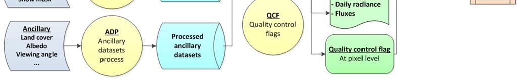
13 GET-D Data Flows 13


14 PRECIPITATION SURFACE TEMPERATURE From Martha Anderson transpiration & evaporation Veg stress parms T soil & T veg transpiration & evaporation T veg soil evaporation Bare soil evap parms Sfc moisture infiltration Soil hydraulic parms runoff T Soil soil evaporation Rootzone moisture drainage Soil moisture holding capacity Root uptake Root distribution parms Given known radiative energy inputs, how much water loss is required to keep the soil and vegetation at the observed temperatures? WATER BALANCE APPROACH ( forward modeling ) REMOTE SENSING APPROACH ( inverse modeling )
15 GET-D Input Data Name Category Source Description Brightness temperature Insolation Vegetation Index Snow mask Air temperature Specific humidity Geopotential height Wind speed Downwelling longwave radiation Land Cover Satellite observation Satellite observation Satellite observation Satellite observation Meteorological data Meteorological data Meteorological data Meteorological data Meteorological data Ancillary data GOES GSIP VIIRS NOAA IMS CFS CFS CFS CFS CFS University of Maryland GOES East/West Imagery; 11micron/3.9 micron brightness temperature GSIP real time insolation VIIRS EVI IMS Daily Northern Hemisphere Snow and Ice Analysis Surface and pressure level profiles Surface and pressure level profiles Surface and pressure level profiles Surface Surface Land cover classes in 1km resolution (static) Albedo Ancillary data MODIS Surface Albedo from MODIS (static) Clear day insolation Ancillary data GSIP Clear day insolation (static) 15
16 GET-D Output Products Variables ET product with QC ESI products with QC Flux products with QC Description Daily ET map 2,4,8, 12 week composite drought map Daily sensible heat, soil heat, downward short wave radiation, long wave down/up ward radiation and net radiation Coverage Spatial Resolution North America 8km 16


17 GET-D Websites NESDIS STAR: htmon/products_droughtmon.php NESDIS OSPO: 17
18 Impacts of Sat Surface Products on NWP models 18
19 Impact of NRT GVF & albedo on Noah SM Noah SM Simulations with Conventional inputs RMSE, Correlation Differences Noah SM Simulations with NRT inputs In situ SM observations RMSE, Correlation 1.Nor RMSE 2.Correlation 3.Anomaly Cor Positive (negative) values represent added (degraded) skill by assimilating NRT observations ID Parameters Description of parameters (resolution and data source) Simulation Temporal Spatial Data source period GVF Climatology 5-year average AVHRR S01 Albedo Climatology 5-year average AVHRR NARR Insolation Hourly NLDAS-2 NARR S02 NRT GVF 8-day composite 1 km MODIS S03 NRT Albedo 8-day composite 1 km MODIS * S01: Noah simulation with climatological parameters of GVF and albedo * S02 03: Noah simulations with single replacement of one of the NRT three parameters as model inputs 19
20 Impact of NRT GVF & albedo on Noah SM Variables Average Normalized RMSE improvement (%) Maximum impact period (MIP) DOY (beg. end.) Maximum Normalized RMSE improvement (%) Number (%) of improved sites Surface Rootzone Surface Rootzone Surface Rootzone Surface Rootzone GVF Albedo Insolation Combined
21 Assimilate SMAP SM with NCEP LIS GFS Use LIS EnKF to assimilate NASA SMAP L3 SM daily with GDAS forcing Initialize GFS T with LIS output of ST and SM (see next flow chart) DA experiments: OLP > LIS run without SM DA and NRT GVF for GFS IC SMAP > assimilate SMAP SM only NRT_GVF > replace multi year GVF with NRT GVF of VIIRS Dual > assimilate SMAP SM and use NRT GVF GFS > no LIS coupling for GFS initial conditions Evaluation: All GFS 3 hour rainfall forecasts are compared with the best available rainfall observations used to drive GLDAS 21

22 Assimilate SMAP SM with NCEP LIS GFS 22
 rainfall")

23 Assimilate SMAP SM with NCEP LIS GFS RMSEs of all GFS (3 hour interval for 7 days) rainfall forecasts from May 2 3, 2015 (112 samples) (yellow and red indicate degradation and blue means improvement) 23
24 Assimilate SMAP SM with NCEP LIS GFS NRT GVF appears to improve GFS rainfall forecasts more significant than satellite soil moisture 24
")
25 Impact of SM Bias Correction Method in DA on GFS Rainfall Forecasts RMSE (mm) Difference Maps: TM pixel monthly CDF GL global CDF TRF monthly av & sd matching SMAP original SMAP OLP no assimilation SMAP data: 4/2015 3/2017 (yellow and red indicate degradation and blue means improvement) 25
26 Impact of SM Bias Correction Method in DA on GFS Rainfall Forecasts SMDA with pixel wise monthly CDF matching for bias correction produced larger impacts on GFS rainfall forecasts depending on vegetation density 26
27 Assimilate SMAP SM with NASA NU WRF Use LIS WRF (NASA NU WRF) to assimilate NASA SMAP L3 SM daily SMDA is done with the EnKF in LIS using the standard set ups DA experiments: CLIM > LIS run with multiyear averages of AVHRR GVF LAI > LIS run with NRT GVF from MODIS LAI EVI > LIS run with NRT GVF from VIIRS EVI SMAPCLIM > SMAP SMDA using averaged AVHRR GVF SMAPLAI > SMAP SMDA using NRT GVF from MODIS LAI Evaluation: All LIS WRF Day 1 and Day 2 forecasts (6 hour interval) of T2m, RH and rainfall against ground observations of 1074 sites over CONUS Forecasts are carried out from April 16 to 22, 2015 using SMAP SM data from April 1 to the forecast time for the SMDA cases 27


28 Assimilate SMAP SM with NASA NU WRF Average Differences of T2m forecasts between with and without SMAP SM DA SMAP SM DA makes T2m forecasts cooler in the western CONUS, and warmer in the eastern CONUS under either averaged or NRT GVF conditions 28

29 Assimilate SMAP SM with NASA NU WRF Average Differences of RH forecasts between with and without SMAP SM DA SMAP SM DA makes RH forecasts wetter in the western CONUS, and slightly drier in the eastern CONUS under either averaged or NRT GVF conditions 29


30 Assimilate SMAP SM with NASA NU WRF Average Differences of total precip forecasts between with and without SMAP SM DA SMAP SM DA makes some differences in total precip in the eastern CONUS under either averaged or NRT GVF conditions 30


31 Assimilate SMAP SM with NASA NU WRF RMSE Differences of T2m forecasts between with and without SMAP SM DA against ground observations of 1074 sites SMAP SM DA may make T2m forecasts better for some and worse for the other locations under either climatological or NRT GVF conditions 31
32 Assimilate SMAP SM with NASA NU WRF Biases and RMSEs of LIS WRF T2m forecasts of Day1 and Day2 with different GVF and SM Setups Generally using NRT GVF may improve LIS WRF T2m forecasts more significant than SMAP SM DA 32
33 Assimilate SMAP SM with NASA NU WRF Biases and RMSEs of LIS WRF RH forecasts of Day1 and Day2 with different GVF and SM Setups Generally using NRT GVF may improve LIS WRF RH forecasts more significant than SMAP SM DA 33


34 Assimilate SMAP SM with NASA NU WRF Statistics of LIS WRF Precipitation Forecasts under various GVF and SMDA setups against Stage IV Data SMAP SM DA did not significantly improve LIS WRF precipitation forecasts as using NRT GVF 34
 Free run, 12km")


35 Assimilate SMAP SM with NASA NU WRF May 2 10, 2015 Gauge obs, ¼ degree (mm) Free run, 12km (mm) Assim Free (mm) After SMAP SM data assimilation, the 9 day daily averaged rainfall forecasts of NUWRF looked closer to the gauge observations than the free run without the DA Nov 2 10,
36 Causes of the Insignificant Impacts GVF: Inconsistent impact assessment might be caused by the GVF product algorithm itself (LAI based/lai?) Albedo: Insignificant inter annual variations so that seasonal average might have represented the reality well at least for the time period studied (dual pass DA?) Soil Moisture: CDF matching for bias correction (dual pass DA?) Observation error variance set up (pixel wise?) Observation accuracy itself (heterogeneity?) Model physics (SM fluxes weather coupling?) 36
37 SUMMARY Many surface data products have been generated from NOAA NESDIS operationally But almost none of them has been used in NOAA NWP operations because of inconsistent impact assessment results In addition to the product accuracy and consistency issues, data assimilation algorithm may have to be investigated further 37
Enhancing Weather Forecasts via Assimilating SMAP Soil Moisture and NRT GVF
 CICS Science Meeting, ESSIC, UMD, 2016 Enhancing Weather Forecasts via Assimilating SMAP Soil Moisture and NRT GVF Li Fang 1,2, Christopher Hain 1,2, Xiwu Zhan 2, Min Huang 1,2 Jifu Yin 1,2, Weizhong Zheng
NOAA Soil Moisture Operational Product System (SMOPS): Version 2
: Version 2") CICS-MD Science Meeting (November 12-13, 2014) NOAA Soil Moisture Operational Product System (SMOPS): Version 2 Jicheng Liu 1, 2, Xiwu Zhan 2, Limin Zhao 3, Christopher R. Hain 1, 2, Li Fang 1,2, Jifu
CICS-MD Science Meeting (November 12-13, 2014) NOAA Soil Moisture Operational Product System (SMOPS): Version 2 Jicheng Liu 1, 2, Xiwu Zhan 2, Limin Zhao 3, Christopher R. Hain 1, 2, Li Fang 1,2, Jifu
National Centers for Environmental Prediction: Building a Weather-Ready Nation
 National Centers for Environmental Prediction: Building a Weather-Ready Nation Dr. William M. Lapenta Director, National Centers for Environmental Prediction NOAA/National Weather Service COPC meeting
Unifying the NCEP Production Suite
 Unifying the NCEP Production Suite Integrated coupled modelling approach at NCEP Michael B. Ek Deputy Director, Environmental Modeling Center (EMC) National Centers for Environmental Prediction (NCEP)
Moving to a simpler NCEP production suite
 Moving to a simpler NCEP production suite Unified coupled global modeling Hendrik L. Tolman Director, Environmental Modeling Center NOAA / NWS / NCEP Hendrik.Tolman@NOAA.gov page 1 of 14 Content The suite
NOAA Update. SPARC DA and S-RIP Workshop October 17-21, 2016 Victoria, BC
 NOAA Update Craig S. Long Bill Lapenta, Hendrik Tolman, Wesley Ebisuzaki, Leigh Zhang, Hyun-Chul Lee, Jack Woolen, Jeff Whitaker NOAA/NWS/NCEP and NOAA/OAR/ESRL Topics Recent Upgrades NCEP Production Suite
NCEP Land-Surface Modeling
 NCEP Land-Surface Modeling Michael Ek and the EMC Land-Hydrology Team Environmental Modeling Center (EMC) National Centers for Environmental Prediction (NCEP) 5200 Auth Road, Room 207 Suitland, Maryland
Land Analysis in the NOAA CFS Reanalysis. Michael Ek, Ken Mitchell, Jesse Meng Helin Wei, Rongqian Yang, and George Gayno
 Land Analysis in the NOAA CFS Reanalysis Michael Ek, Ken Mitchell, Jesse Meng Helin Wei, Rongqian Yang, and George Gayno 1 Outline CFS Reanalysis execution Land surface model upgrade from OSU to Noah LIS/GLDAS
Frontiers of Numerical Weather Prediction
 Frontiers of Numerical Weather Prediction James G. (Jim) Yoe NOAA/National Weather Service National Centers for Environmental Prediction National Academy of Sciences Committee on Earth Sciences and Applications
Implementation of Land Information System in the NCEP Operational Climate Forecast System CFSv2. Jesse Meng, Michael Ek, Rongqian Yang, Helin Wei
 Implementation of Land Information System in the NCEP Operational Climate Forecast System CFSv2 Jesse Meng, Michael Ek, Rongqian Yang, Helin Wei 1 Outline NCEP CFSRR Land component CFSv1 vs CFSv2 Land
The NOAA Operational Numerical Guidance System: Recent Changes and Moving Forward. William. M. Lapenta Acting Director Environmental Modeling Center
 AMS Future of the Weather Enterprise 11/27/12 1 N C E P The NOAA Operational Numerical Guidance System: Recent Changes and Moving Forward William. M. Lapenta Acting Director Environmental Modeling Center
Land Data Assimilation at NCEP NLDAS Project Overview, ECMWF HEPEX 2004
 Dag.Lohmann@noaa.gov, Land Data Assimilation at NCEP NLDAS Project Overview, ECMWF HEPEX 2004 Land Data Assimilation at NCEP: Strategic Lessons Learned from the North American Land Data Assimilation System
Land data assimilation in the NASA GEOS-5 system: Status and challenges
 Blueprints for Next-Generation Data Assimilation Systems Boulder, CO, USA 8-10 March 2016 Land data assimilation in the NASA GEOS-5 system: Status and challenges Rolf Reichle Clara Draper, Ricardo Todling,
Multivariate assimilation of satellite-derived remote sensing datasets in the North American Land Data Assimilation System (NLDAS)
") Multivariate assimilation of satellite-derived remote sensing datasets in the North American Land Data Assimilation System (NLDAS) Sujay V. Kumar 1,2, Christa D. Peters-Lidard 1, David Mocko 1,2,3, Rolf
Multivariate assimilation of satellite-derived remote sensing datasets in the North American Land Data Assimilation System (NLDAS) Sujay V. Kumar 1,2, Christa D. Peters-Lidard 1, David Mocko 1,2,3, Rolf
Assimilation of satellite derived soil moisture for weather forecasting
 Assimilation of satellite derived soil moisture for weather forecasting www.cawcr.gov.au Imtiaz Dharssi and Peter Steinle February 2011 SMOS/SMAP workshop, Monash University Summary In preparation of the
Evaluation of remotely sensed and modelled soil moisture products using global ground-based in situ observations
 Evaluation of remotely sensed and modelled soil moisture products using global ground-based in situ observations C. Albergel (1), P. de Rosnay (1), G. Balsamo (1),J. Muñoz-Sabater(1 ), C. Gruhier (2),
Climate Models and Snow: Projections and Predictions, Decades to Days
 Climate Models and Snow: Projections and Predictions, Decades to Days Outline Three Snow Lectures: 1. Why you should care about snow 2. How we measure snow 3. Snow and climate modeling The observational
Assimilation of the AFWA Snow Depth Product into NCEP Operational CFS/GFS System
 Assimilation of the AFWA Snow Depth Product into NCEP Operational CFS/GFS System Jiarui Dong, Mie E NOAA/NCEP/EMC, College Par, Maryland, USA Sujay Kumar, Christa Peters-Lidard NASA/GSFC, Greenbelt, Maryland,
Efforts to Assimilate the AFWA Snow Depth Product into NCEP Operational CFS/GFS System
 Efforts to Assimilate the AFWA Snow Depth Product into NCEP Operational CFS/GFS System J. Dong, Mie E, W. Zheng, H. Wei, J. Meng NOAA/NCEP/EMC, College Par, Maryland, USA X. Zhan NOAA/NESDIS/STAR, College
Assimilation of ASCAT soil wetness
 EWGLAM, October 2010 Assimilation of ASCAT soil wetness Bruce Macpherson, on behalf of Imtiaz Dharssi, Keir Bovis and Clive Jones Contents This presentation covers the following areas ASCAT soil wetness
The Canadian Land Data Assimilation System (CaLDAS)
") The Canadian Land Data Assimilation System (CaLDAS) Marco L. Carrera, Stéphane Bélair, Bernard Bilodeau and Sheena Solomon Meteorological Research Division, Environment Canada Dorval, QC, Canada 2 nd Workshop
The Canadian Land Data Assimilation System (CaLDAS) Marco L. Carrera, Stéphane Bélair, Bernard Bilodeau and Sheena Solomon Meteorological Research Division, Environment Canada Dorval, QC, Canada 2 nd Workshop
Operational Ocean and Climate Modeling at NCEP
 Operational Ocean and Climate Modeling at NCEP 5 th Annual CoRP Science Symposium Corvallis, OR Aug. 12-13, 2008 Hua-Lu Pan and Hendrik Tolman Environmental Modeling Center NCEP 1.7B Obs/Day Satellites
Aquarius/SAC-D Soil Moisture Product using V3.0 Observations
 Aquarius/SAC-D Soil Moisture Product using V3. Observations R. Bindlish, T. Jackson, M. Cosh November 214 Overview Soil moisture algorithm Soil moisture product Validation Linkage between Soil Moisture
Interaction of North American Land Data Assimilation System and National Soil Moisture Network: Soil Products and Beyond
 Interaction of North American Land Data Assimilation System and National Soil Moisture Network: Soil Products and Beyond Youlong Xia 1,2, Michael B. Ek 1, Yihua Wu 1,2, Christa Peters-Lidard 3, David M.
ECMWF. ECMWF Land Surface modelling and land surface analysis. P. de Rosnay G. Balsamo S. Boussetta, J. Munoz Sabater D.
 Land Surface modelling and land surface analysis P. de Rosnay G. Balsamo S. Boussetta, J. Munoz Sabater D. Vasiljevic M. Drusch, K. Scipal SRNWP 12 June 2009 Slide 1 Surface modelling (G. Balsamo) HTESSEL,
Mapping Evapotranspiration and Drought at Local to Continental Scales Using Thermal Remote Sensing
 Mapping Evapotranspiration and Drought at Local to Continental Scales Using Thermal Remote Sensing M.C. Anderson, W.P. Kustas USDA-ARS, Hydrology and Remote Sensing Laboratory J.M Norman University of
GABLS4 Results from NCEP Single Column Model
 GABLS4 Results from NCEP Single Column Model Weizhong Zheng 1,2, Michael Ek 1,Ruiyu Sun 1,2 and Jongil Han 1,2 1 NOAA/NCEP/Environmental Modeling Center(EMC), USA 2 IMSG@NOAA/NCEP/EMC, USA Email: Weizhong.Zheng@noaa.gov
Evaporative Fraction and Bulk Transfer Coefficients Estimate through Radiometric Surface Temperature Assimilation
 Evaporative Fraction and Bulk Transfer Coefficients Estimate through Radiometric Surface Temperature Assimilation Francesca Sini, Giorgio Boni CIMA Centro di ricerca Interuniversitario in Monitoraggio
NDIA System Engineering Conference 26 October Benjie Spencer Chief Engineer, NOAA/National Weather Service
 NDIA System Engineering Conference 26 October 2015 Benjie Spencer Chief Engineer, NOAA/National Weather Service The National Weather Service of the Future: Building a Weather-Ready Nation Previous NWS
Recent Data Assimilation Activities at Environment Canada
 Recent Data Assimilation Activities at Environment Canada Major upgrade to global and regional deterministic prediction systems (now in parallel run) Sea ice data assimilation Mark Buehner Data Assimilation
The Canadian Precipitation Analysis (CaPA) and the Canadian Land Data Assimilation System (CaLDAS)
 and the Canadian Land Data Assimilation System (CaLDAS)") The Canadian Precipitation Analysis (CaPA) and the Canadian Land Data Assimilation System (CaLDAS) Vincent Fortin (and many collaborators) Division de la recherche en météorologie Environnement en Changement
The Canadian Precipitation Analysis (CaPA) and the Canadian Land Data Assimilation System (CaLDAS) Vincent Fortin (and many collaborators) Division de la recherche en météorologie Environnement en Changement
ECMWF. ECMWF Land Surface Analysis: Current status and developments. P. de Rosnay M. Drusch, K. Scipal, D. Vasiljevic G. Balsamo, J.
 Land Surface Analysis: Current status and developments P. de Rosnay M. Drusch, K. Scipal, D. Vasiljevic G. Balsamo, J. Muñoz Sabater 2 nd Workshop on Remote Sensing and Modeling of Surface Properties,
Validation of satellite derived snow cover data records with surface networks and m ulti-dataset inter-comparisons
 Validation of satellite derived snow cover data records with surface networks and m ulti-dataset inter-comparisons Chris Derksen Climate Research Division Environment Canada Thanks to our data providers:
Assimilation of Snow and Ice Data (Incomplete list)
") Assimilation of Snow and Ice Data (Incomplete list) Snow/ice Sea ice motion (sat): experimental, climate model Sea ice extent (sat): operational, U.S. Navy PIPs model; Canada; others? Sea ice concentration
Assimilation of Snow and Ice Data (Incomplete list) Snow/ice Sea ice motion (sat): experimental, climate model Sea ice extent (sat): operational, U.S. Navy PIPs model; Canada; others? Sea ice concentration
Some NOAA Products that Address PSTG Satellite Observing Requirements. Jeff Key NOAA/NESDIS Madison, Wisconsin USA
 Some NOAA Products that Address PSTG Satellite Observing Requirements Jeff Key NOAA/NESDIS Madison, Wisconsin USA WMO Polar Space Task Group, 4 th meeting, Greenbelt, 30 September 2014 Relevant Missions
ASSESSMENT OF NORTHERN HEMISPHERE SWE DATASETS IN THE ESA SNOWPEX INITIATIVE
 ASSESSMENT OF NORTHERN HEMISPHERE SWE DATASETS IN THE ESA SNOWPEX INITIATIVE Kari Luojus 1), Jouni Pulliainen 1), Matias Takala 1), Juha Lemmetyinen 1), Chris Derksen 2), Lawrence Mudryk 2), Michael Kern
Joint International Surface Working Group and Satellite Applications Facility on Land Surface Analysis Workshop, IPMA, Lisboa, June 2018
 Joint International Surface Working Group and Satellite Applications Facility on Land Surface Analysis Workshop, IPMA, Lisboa, 26-28 June 2018 Introduction Soil moisture Evapotranspiration Future plan
The National Weather Service of the Future: Building a Weather-Ready Nation
 The of the Future: Building a Weather-Ready Nation Dr. Louis W. Uccellini Director, NOAA Assistant Administrator for Weather Services NCEP Production Suite Review December 2, 2014 Outline Building a Weather-Ready
Global Satellite Products & Services for Agricultural and Vegetation Health
 Global Satellite Products & Services for Agricultural and Vegetation Health Presented at the WMO Expert Meeting on National Early Warning System for Agricultural Weather Management George Mason University
Arctic System Reanalysis Provides Highresolution Accuracy for Arctic Studies
 Arctic System Reanalysis Provides Highresolution Accuracy for Arctic Studies David H. Bromwich, Aaron Wilson, Lesheng Bai, Zhiquan Liu POLAR2018 Davos, Switzerland Arctic System Reanalysis Regional reanalysis
Weather Forecasting: Lecture 2
 Weather Forecasting: Lecture 2 Dr. Jeremy A. Gibbs Department of Atmospheric Sciences University of Utah Spring 2017 1 / 40 Overview 1 Forecasting Techniques 2 Forecast Tools 2 / 40 Forecasting Techniques
SMAP and SMOS Integrated Soil Moisture Validation. T. J. Jackson USDA ARS
 SMAP and SMOS Integrated Soil Moisture Validation T. J. Jackson USDA ARS Perspective Linkage of SMOS and SMAP soil moisture calibration and validation will have short and long term benefits for both missions.
A Facility for Producing Consistent Remotely Sensed Biophysical Data Products of Australia
 TERRESTRIAL ECOSYSTEM RESEARCH NETWORK - AusCover - A Facility for Producing Consistent Remotely Sensed Biophysical Data Products of Australia June, 2011 Mervyn Lynch Professor of Remote Sensing Curtin
Michael B. Ek 1, Youlong Xia 1,2, Jesse Meng 1,2, and Jiarui Dong 1,2
 Michael B. Ek 1, Youlong Xia 1,2, Jesse Meng 1,2, and Jiarui Dong 1,2 1 Land-Hydrology Team Environmental Modeling Center (EMC) National Centers for Environmental Prediction (NCEP) National Weather Service
Implementation of the NCEP operational GLDAS for the CFS land initialization
 Implementation of the NCEP operational GLDAS for the CFS land initialization Jesse Meng, Mickael Ek, Rongqian Yang NOAA/NCEP/EMC July 2012 1 Improving the Global Land Surface Climatology via improved Global
Long range dust transport and its impact on US air quality
 Long range dust transport and its impact on US air quality Sarah Lu 1, Youhua Tang 1, Ho Chun Huang 1, Jeff McQueen 1, Arlindo da Silva 2, Mian Chin 2, Marina Tsidulko 1, Jianping Huang 1 1 : NOAA NCEP
Estimation via Data Assimilation Using. Mississippi State University GeoResources Institute
 High Resolution Soil Moisture Estimation via Data Assimilation Using NASA Land Information System Mississippi State University GeoResources Institute LIS Evaluation Team & Collaborators RPC Team Valentine
Land Surface Processes and Their Impact in Weather Forecasting
 Land Surface Processes and Their Impact in Weather Forecasting Andrea Hahmann NCAR/RAL with thanks to P. Dirmeyer (COLA) and R. Koster (NASA/GSFC) Forecasters Conference Summer 2005 Andrea Hahmann ATEC
METRIC tm. Mapping Evapotranspiration at high Resolution with Internalized Calibration. Shifa Dinesh
 METRIC tm Mapping Evapotranspiration at high Resolution with Internalized Calibration Shifa Dinesh Outline Introduction Background of METRIC tm Surface Energy Balance Image Processing Estimation of Energy
AQRP Project Use of Satellite Data to Improve Specifications of Land Surface Parameters
 AQRP Project 14-022 Use of Satellite Data to Improve Specifications of Land Surface Parameters By Richard T. McNider, Kevin Doty and Yu Ling Wu, ESSC University of Alabama Huntsville And Pius Lee NOAA
Drought Monitoring with Hydrological Modelling
 st Joint EARS/JRC International Drought Workshop, Ljubljana,.-5. September 009 Drought Monitoring with Hydrological Modelling Stefan Niemeyer IES - Institute for Environment and Sustainability Ispra -
Current status of lake modelling and initialisation at ECMWF
 Current status of lake modelling and initialisation at ECMWF G Balsamo, A Manrique Suñen, E Dutra, D. Mironov, P. Miranda, V Stepanenko, P Viterbo, A Nordbo, R Salgado, I Mammarella, A Beljaars, H Hersbach
Land surface data assimilation for Numerical Weather Prediction
 Sixth WMO Symposium on Data Assimilation, University of Maryland, 7-11 October 2013 Land surface data assimilation for Numerical Weather Prediction P. de Rosnay, J. Muñoz Sabater, C. Albergel, G. Balsamo,
Development of the Canadian Precipitation Analysis (CaPA) and the Canadian Land Data Assimilation System (CaLDAS)
 and the Canadian Land Data Assimilation System (CaLDAS)") Development of the Canadian Precipitation Analysis (CaPA) and the Canadian Land Data Assimilation System (CaLDAS) Marco L. Carrera, Vincent Fortin and Stéphane Bélair Meteorological Research Division Environment
Development of the Canadian Precipitation Analysis (CaPA) and the Canadian Land Data Assimilation System (CaLDAS) Marco L. Carrera, Vincent Fortin and Stéphane Bélair Meteorological Research Division Environment
Improving Streamflow Prediction in Snow- fed River Basins via Satellite Snow Assimilation
 Improving Streamflow Prediction in Snow- fed River Basins via Satellite Snow Assimilation Yuqiong Liu NASA GSFC & University of Maryland, College Park Co- authors: Christa Peters- Lidard, Sujay Kumar,
May 3, :41 AOGS - AS 9in x 6in b951-v16-ch13 LAND SURFACE ENERGY BUDGET OVER THE TIBETAN PLATEAU BASED ON SATELLITE REMOTE SENSING DATA
 Advances in Geosciences Vol. 16: Atmospheric Science (2008) Eds. Jai Ho Oh et al. c World Scientific Publishing Company LAND SURFACE ENERGY BUDGET OVER THE TIBETAN PLATEAU BASED ON SATELLITE REMOTE SENSING
CLAVR-x is the Clouds from AVHRR Extended Processing System. Responsible for AVHRR cloud products and other products at various times.
 CLAVR-x in CSPP Andrew Heidinger, NOAA/NESDIS/STAR, Madison WI Nick Bearson, SSEC, Madison, WI Denis Botambekov, CIMSS, Madison, WI Andi Walther, CIMSS, Madison, WI William Straka III, CIMSS, Madison,
Using VIIRS Land Surface Temperature to Evaluate NCEP North American Mesoscale Model (NAM) Forecast
 Forecast") Using VIIRS Land Surface Temperature to Evaluate NCEP North American Mesoscale Model (NAM) Forecast Zhuo Wang (University of Maryland) Yunyue Yu (NOAA/NESDIS/STAR) Peng Yu (University of Maryland) Yuling
Using VIIRS Land Surface Temperature to Evaluate NCEP North American Mesoscale Model (NAM) Forecast Zhuo Wang (University of Maryland) Yunyue Yu (NOAA/NESDIS/STAR) Peng Yu (University of Maryland) Yuling
Unidata Policy Meeting Key Program Status
 Unidata Policy Meeting Key Program Status May 14, 2013 Where America s Climate, Weather, Ocean and Space Weather Services Begin Agenda Sandy Supplemental Integrated Dissemination Program AWIPS2 May, 2013
High resolution land reanalysis
 Regional Reanalysis Workshop 19-20 May 2016, Reading High resolution land reanalysis P. de Rosnay, G. Balsamo, J. Muñoz Sabater, E. Dutra, C. Albergel, N. Rodríguez-Fernández, H. Hersbach Introduction:
Arctic System Reanalysis *
 Arctic System Reanalysis * David H. Bromwich 1,2, Keith M. Hines 1 and Le-Sheng Bai 1 1 Polar Meteorology Group, Byrd Polar Research Center 2 Atmospheric Sciences Program, Dept. of Geography The Ohio State
Hyperlocal Marine Weather: What s Happening?
 Hyperlocal Marine Weather: What s Happening? André van der Westhuysen 1,2 and Jeff McQueen 1 1 NOAA / National Weather Service National Centers for Environmental Prediction 2 I.M Systems Group, Rockville
The EMC Mission.. In response to operational requirements:
 The EMC Mission.. In response to operational requirements: Maintain operational model suite The scientific correctness and integrity of operational forecast modeling systems Modify current operational
The role of soil moisture in influencing climate and terrestrial ecosystem processes
 1of 18 The role of soil moisture in influencing climate and terrestrial ecosystem processes Vivek Arora Canadian Centre for Climate Modelling and Analysis Meteorological Service of Canada Outline 2of 18
Modelling and Data Assimilation Needs for improving the representation of Cold Processes at ECMWF
 Modelling and Data Assimilation Needs for improving the representation of Cold Processes at ECMWF presented by Gianpaolo Balsamo with contributions from Patricia de Rosnay, Richard Forbes, Anton Beljaars,
CONDUIT Update Cooperative Opportunity for NCEP Data using IDD Technology Rebecca Cosgrove NCEP/NCO/Production Management Branch September 15, 2014
 CONDUIT Update Cooperative Opportunity for NCEP Data using IDD Technology Rebecca Cosgrove NCEP/NCO/Production Management Branch September 15, 2014 Agenda Technology Refresh Data available today NOAAPORT/SBN
N C E P. Ensemble Systems within the NOAA Operational Modeling Suite. William. M. Lapenta Acting Director Environmental Modeling Center NOAA/NWS/NCEP
 US THORPE 19 Sept 2012 1 N C E P Ensemble Systems within the NOAA Operational Modeling Suite William. M. Lapenta Acting Director Environmental Modeling Center NOAA/NWS/NCEP Data Assimilation, Modeling
Assimilation of land surface satellite data for Numerical Weather Prediction at ECMWF
 4 th workshop on Remote Sensing and Modelling of Surface properties Saint Martin d Hères, 14-16 March 2016 Assimilation of land surface satellite data for Numerical Weather Prediction at ECMWF P. de Rosnay,
Improvements to the NCEP Global and Regional Data Assimilation Systems
 Improvements to the NCEP Global and Regional Data Assimilation Systems Stephen J. Lord Director NCEP Environmental Modeling Center EMC Staff NCEP: where America s climate, weather, and ocean services begin
GLOBAL LAND DATA ASSIMILATION SYSTEM (GLDAS) PRODUCTS FROM NASA HYDROLOGY DATA AND INFORMATION SERVICES CENTER (HDISC) INTRODUCTION
 PRODUCTS FROM NASA HYDROLOGY DATA AND INFORMATION SERVICES CENTER (HDISC) INTRODUCTION") GLOBAL LAND DATA ASSIMILATION SYSTEM (GLDAS) PRODUCTS FROM NASA HYDROLOGY DATA AND INFORMATION SERVICES CENTER (HDISC) Hongliang Fang, Patricia L. Hrubiak, Hiroko Kato, Matthew Rodell, William L. Teng,
GLOBAL LAND DATA ASSIMILATION SYSTEM (GLDAS) PRODUCTS FROM NASA HYDROLOGY DATA AND INFORMATION SERVICES CENTER (HDISC) Hongliang Fang, Patricia L. Hrubiak, Hiroko Kato, Matthew Rodell, William L. Teng,
5. General Circulation Models
 5. General Circulation Models I. 3-D Climate Models (General Circulation Models) To include the full three-dimensional aspect of climate, including the calculation of the dynamical transports, requires
NCEP Aerosol Data Assimilation Update: Improving NCEP global aerosol forecasts using JPSS-NPP VIIRS aerosol products
 NCEP Aerosol Data Assimilation Update: Improving NCEP global aerosol forecasts using JPSS-NPP VIIRS aerosol products Sarah Lu, Shih-Wei Wei (SUNYA) Shobha Kondragunta, Qiang Zhao (NESDIS/STAR) Jeff McQueen,
HMON (HNMMB): Development of a new Hurricane model for NWS/NCEP operations
: Development of a new Hurricane model for NWS/NCEP operations") 1 HMON (HNMMB): Development of a new Hurricane model for NWS/NCEP operations Avichal Mehra, EMC Hurricane and Mesoscale Teams Environmental Modeling Center NOAA / NWS / NCEP HMON: A New Operational Hurricane
1 HMON (HNMMB): Development of a new Hurricane model for NWS/NCEP operations Avichal Mehra, EMC Hurricane and Mesoscale Teams Environmental Modeling Center NOAA / NWS / NCEP HMON: A New Operational Hurricane
Modeling the Arctic Climate System
 Modeling the Arctic Climate System General model types Single-column models: Processes in a single column Land Surface Models (LSMs): Interactions between the land surface, atmosphere and underlying surface
The Community Noah LSM with Multi-physics Options
 The Community Noah LSM with Multi-physics Options Guo-Yue Niu Collaborators: ZL Yang, KE Mitchell, F Chen, MB Ek, M. Barlage, L. Longuevergne, A Kumar, K Manning, D Niyogi, E Rosero, M Tewari, and Y. Xia
NESDIS Global Automated Satellite Snow Product: Current Status and Recent Results Peter Romanov
 NESDIS Global Automated Satellite Snow Product: Current Status and Recent Results Peter Romanov NOAA-CREST, City University of New York (CUNY) Center for Satellite Applications and Research (STAR), NOAA/NESDIS
The National Operational Hydrologic Remote Sensing Center Operational Snow Analysis
 The National Operational Hydrologic Remote Sensing Center Operational Snow Analysis World Meteorological Organization Global Cryosphere Watch Snow-Watch Workshop Session 3: Snow Analysis Products Andrew
The Developmental Testbed Center: Update on Data Assimilation System Testing and Community Support
 93rd AMS Annual Meeting/17th IOAS-AOLS/3rd Conference on Transition of Research to Operations, Austin, TX, Jan 6-10, 2013 The Developmental Testbed Center: Update on Data Assimilation System Testing and
A Description and Example Output of the WRF-NMM land surface and radiation packages used at NCEP
 A Description and Example Output of the WRF-NMM land surface and radiation packages used at NCEP Ken Mitchell and Michael Ek NCEP/EMC NOAA/NWS WRF-NMM Tutorial 8-11 August 2006 Boulder, CO Noah Land Surface
Soil Moisture Prediction and Assimilation
 Soil Moisture Prediction and Assimilation Analysis and Prediction in Agricultural Landscapes Saskatoon, June 19-20, 2007 STEPHANE BELAIR Meteorological Research Division Prediction and Assimilation Atmospheric
Assimilation of Satellite Sea-surface Salinity Fields: Validating Ocean Analyses and Identifying Errors in Surface Buoyancy Fluxes
 Assimilation of Satellite Sea-surface Salinity Fields: Validating Ocean Analyses and Identifying Errors in Surface Buoyancy Fluxes Eric Bayler Sudhir Nadiga Avichal Mehra David Behringer NOAA/NESDIS/STAR
Improved analyses and forecasts with AIRS retrievals using the Local Ensemble Transform Kalman Filter
 Improved analyses and forecasts with AIRS retrievals using the Local Ensemble Transform Kalman Filter Hong Li, Junjie Liu, and Elana Fertig E. Kalnay I. Szunyogh, E. J. Kostelich Weather and Chaos Group
Terrestrial Snow Cover: Properties, Trends, and Feedbacks. Chris Derksen Climate Research Division, ECCC
 Terrestrial Snow Cover: Properties, Trends, and Feedbacks Chris Derksen Climate Research Division, ECCC Outline Three Snow Lectures: 1. Why you should care about snow: Snow and the cryosphere Classes of
NESDIS Global Automated Satellite Snow Product: Current Status and Planned Upgrades Peter Romanov
 NESDIS Global Automated Satellite Snow Product: Current Status and Planned Upgrades Peter Romanov NOAA-CREST, City University of New York (CUNY) Center for Satellite Applications and Research (STAR), NOAA/NESDIS
Impact of assimilating the VIIRS-based CrIS cloudcleared radiances on hurricane forecasts
 Impact of assimilating the VIIRS-based CrIS cloudcleared radiances on hurricane forecasts Jun Li @, Pei Wang @, Jinlong Li @, Zhenglong Li @, Jung-Rim Lee &, Agnes Lim @, Timothy J. Schmit #, and Mitch
Outline. Part I (Monday) Part II (Tuesday) ECMWF. Introduction Snow analysis Screen level parameters analysis
 Part II (Tuesday) ECMWF. Introduction Snow analysis Screen level parameters analysis") Outline Part I (Monday) Introduction Snow analysis Screen level parameters analysis Part II (Tuesday) Soil moisture analysis OI and EKF analyses Use of satellite data: ASCAT and SMOS Summary and future
Outline Part I (Monday) Introduction Snow analysis Screen level parameters analysis Part II (Tuesday) Soil moisture analysis OI and EKF analyses Use of satellite data: ASCAT and SMOS Summary and future
OSE/OSSEs at NOAA. Eric Bayler NOAA/NESDIS/STAR
 OSE/OSSEs at NOAA Eric Bayler NOAA/NESDIS/STAR OSE/OSSEs at NOAA NOAA Leadership view: Relatively inexpensive way to: Assess the impact of potential new observations Refine and redirect current observing
Operational Uses of Bands on the GOES-R Advanced Baseline Imager (ABI) Presented by: Kaba Bah
 Presented by: Kaba Bah") Operational Uses of Bands on the GOES-R Advanced Baseline Imager (ABI) Presented by: Kaba Bah Topics: Introduction to GOES-R & ABI ABI individual bands Use of band differences ABI derived products Conclusions
Operational Uses of Bands on the GOES-R Advanced Baseline Imager (ABI) Presented by: Kaba Bah Topics: Introduction to GOES-R & ABI ABI individual bands Use of band differences ABI derived products Conclusions
Real-Time Meteorological Gridded Data: What s New With HEC-RAS
 Real-Time Meteorological Gridded Data: What s New With HEC-RAS Acquisition and Application of Gridded Meteorological Data in Support of the USACE s Real-Time Water Management Mission Fauwaz Hanbali, Tom
ASSIMILATION OF CLOUDY AMSU-A MICROWAVE RADIANCES IN 4D-VAR 1. Stephen English, Una O Keeffe and Martin Sharpe
 ASSIMILATION OF CLOUDY AMSU-A MICROWAVE RADIANCES IN 4D-VAR 1 Stephen English, Una O Keeffe and Martin Sharpe Met Office, FitzRoy Road, Exeter, EX1 3PB Abstract The assimilation of cloud-affected satellite
Land surface precipitation and hydrology in MERRA-2
 Land surface precipitation and hydrology in MERRA-2 R. Reichle, R. Koster, C. Draper, Q. Liu, M. Girotto, S. Mahanama, G. De Lannoy, G. Partyka, and many others 5th International Conference on Reanalysis
4DVAR Data Assimilation with Chesapeake Bay Operational Forecasting System
 4DVAR Data Assimilation with Chesapeake Bay Operational Forecasting System Bin Zhang1, Matt Hoffman2, Lyon Lanerolle3, Chris Brown1,4 1 Cooperative Institute of Climate & Satellites/Earth System Science
Land Data Assimilation for operational weather forecasting
 Land Data Assimilation for operational weather forecasting Brett Candy Richard Renshaw, JuHyoung Lee & Imtiaz Dharssi * *Centre Australian Weather and Climate Research Contents An overview of the Current
Soil frost from microwave data. Kimmo Rautiainen, Jouni Pulliainen, Juha Lemmetyinen, Jaakko Ikonen, Mika Aurela
 Soil frost from microwave data Kimmo Rautiainen, Jouni Pulliainen, Juha Lemmetyinen, Jaakko Ikonen, Mika Aurela Why landscape freeze/thaw? Latitudinal variation in mean correlations (r) between annual
Extending the use of surface-sensitive microwave channels in the ECMWF system
 Extending the use of surface-sensitive microwave channels in the ECMWF system Enza Di Tomaso and Niels Bormann European Centre for Medium-range Weather Forecasts Shinfield Park, Reading, RG2 9AX, United
Water Balance in the Murray-Darling Basin and the recent drought as modelled with WRF
 18 th World IMACS / MODSIM Congress, Cairns, Australia 13-17 July 2009 http://mssanz.org.au/modsim09 Water Balance in the Murray-Darling Basin and the recent drought as modelled with WRF Evans, J.P. Climate
1. Current atmospheric DA systems 2. Coupling surface/atmospheric DA 3. Trends & ideas
 1 Current issues in atmospheric data assimilation and its relationship with surfaces François Bouttier GAME/CNRM Météo-France 2nd workshop on remote sensing and modeling of surface properties, Toulouse,
Land Surface Temperature Measurements From the Split Window Channels of the NOAA 7 Advanced Very High Resolution Radiometer John C.
 Land Surface Temperature Measurements From the Split Window Channels of the NOAA 7 Advanced Very High Resolution Radiometer John C. Price Published in the Journal of Geophysical Research, 1984 Presented
Impact of vegetation cover estimates on regional climate forecasts
 Impact of vegetation cover estimates on regional climate forecasts Phillip Stauffer*, William Capehart*, Christopher Wright**, Geoffery Henebry** *Institute of Atmospheric Sciences, South Dakota School
Overview of sea ice data assimilation activities at Environment Canada
 Overview of sea ice data assimilation activities at Environment Canada Mark Buehner, Alain Caya and Michael Ross Meteorological Research Division Tom Carrieres, Lynn Pogson and Yi Luo Marine and Ice Services