South Carolina s Historic Rains and Flooding October 2015 // October Hope Mizzell, Ph.D. SC State Climatologist
|
|
|
- Nigel Waters
- 5 years ago
- Views:
Transcription


1 South Carolina s Historic Rains and Flooding October 2015 // October 2016 Hope Mizzell, Ph.D. SC State Climatologist


2 NOAA Forecasts October 2015 Issued Oct 1, 5:45 AM Issued Oct 2, 5:45 AM Issued Oct 3, 7:55 AM

3

4 Infrared satellite from the morning of Oct. 3 shows an intense area of rainfall being funneled into SC. Hurricane Joaquin peaked as a Category 4 hurricane with maximum sustained winds of 155 mph at that time. NASA

5 NOAA Water Vapor with Overlay of Parameters Contributing to the Heavy Rain

6
7
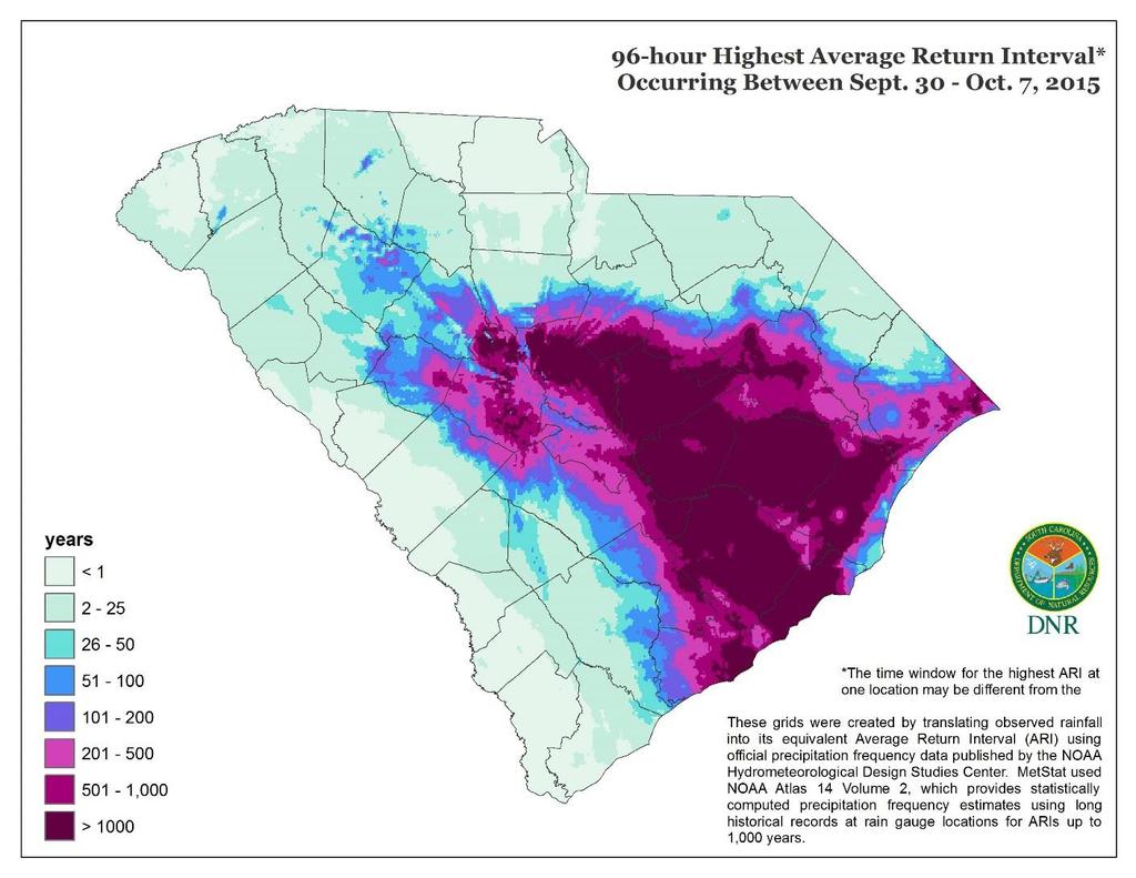
8 Precipitation (in) NOAA ATLAS 14 POINT PRECIPITATION FREQUENCY ESTIMATES Preliminary Analysis for Sumter, SC: Sep 28-Oct 6, Sumter, South Carolina: Sept Oct. 6 Average Return Interval 25 Years 50 Years Years 200 Years Years 1000 Years 5 Precip Total (in) 0 24-hour 2-day 3-day 4-day 7-day 10-day 30-day Based on Greatest 24-hr and Consecutive (2-day, 3-day, 4-day, 7-day) interval days Based on NOAA Atlas 14 Precipitation Frequency Estimates
9 Precipitation (inches) NOAA ATLAS 14 POINT PRECIPITATION FREQUENCY ESTIMATES Preliminary Analysis for Columbia, AP: Sep 28-Oct 6, Columbia Metro Airport: Sept Oct Average Return Interval 25 Years 50 Years 100 Years 200 Years 500 Years 1000 years 0 24-hr 2-day 3-day 43-day 7-day 10-day 30-day Greatest 24-hr and Consecutive (2-day, 3-day, 4-day) interval days Based on NOAA Atlas 14 Point Precipitation Frequency Estimates

10
11 Rainfall (inches) 25 Ft. Jackson Accumulated Hourly Rainfall Oct. 2 Oct. 3 Oct. 4 Oct. 5


12 Gills Creek Watershed, Richland County Gills Creek Watershed is among the largest impaired urban watersheds in SC, and contains over 70 miles of streams and lakes, and 47,000 acres of land. The watershed is included in the cities of Columbia, Cayce, Forest Acres, and Arcadia Lakes; Richland County, and the US Army's Fort Jackson. The population is 140,000.


13 Before Before After After

14 October 4, 2015 Skii Lane Cary Lake Dam Photo by Wes Tyler

15 October 4, 2015 Trenholm Road, North Forest Drive Photo by Wes Tyler October 4, 2015 Quail Lane Lake Katherine Photo by Wes Tyler


16 Before After

17 Selected USGS Stream Gages Enoree River at Whitmire 18,400 cfs peak on 10/5 50 year flow Lynches River at Effingham 17,000 cfs peak on 10/6 50 year flow Congaree River at Columbia 185,000 cfs peak on 10/4 10 year flow Black River at Kingstree 83,700 cfs peak on 10/ year flow Edisto near Ghivans 25,600 cfs peak on 10/9 50 year flow


18

19 Hartwell, Russell, and Thurmond No change Reservoirs Lake Wylie No change Lake Wateree 21,300 cfs Average is 3,000 cfs Lake Murray 56,000 cfs. Average is 2,000 cfs Lake Marion + Moultrie 100,000 cfs (estimate, some data missing) Average is 6,600 cfs

20


21 Interactive Journal of the Historic Rain and Flooding

22 Hurricane Matthew


23 NOAA Forecasts October 2016 Issued Oct 5, 8:00 AM Issued Oct 6, 4:33 AM Issued Issued Oct Oct 7, 4:33 7 4:33 AM AM


24

25 Hurricane Matthew First SC hurricane landfall since Hurricane Charley and Gaston came ashore in Made landfall on SC coast, near McClellanville, on Oct. 8th, 2016, 10:45 AM EDT, as a Category 1 hurricane with 75 mph winds.
26 Hurricane Matthew Developed into a rare 160 mph Category 5 hurricane in central Caribbean during first week of October. Decimated portions of Haiti and Bahamas with torrential rains and 145 mph winds. In the days just prior to landfall Matthew battered the east coast of Florida and Georgia

27 Impacts to South Carolina Matthew triggered the evacuation of the entire SC coast and the first successful complete lane reversal of Interstate 26 from Charleston to Columbia. 77 emergency shelters were opened Severe beach erosion and hurricane force gusts downed thousands of trees along coast and well inland. Produced inches of rain from Savannah through Florence and into a wide area of eastern NC. Heavy rain forced rivers in eastern SC and NC above major flood stage.

28 A federal major disaster declaration for 26 SC counties was issued Oct. 11 th in response to: 355,000 displaced citizens homes damaged or destroyed 25 breached dams 866,000 household power outages Pervasive flooding along the Great Pee Dee, Little Pee Dee, Waccamaw, Black and Lynches Rivers.


29 Wind Gusts Maximum sustained winds were 165 mph with gusts to 190 mph late on Sep. 30 th in central Caribbean. First Atlantic Category 5 hurricane since Hurricane Felix in Weakened significantly prior to landfall in SC. Hurricane force wind gusts were observed along SC coast with the highest gust, 103 mph, recorded by an elevated instrument tower in Winyah Bay.


30 Chronological Narrative of Hurricane Matthew Friday Oct 7 7:00 am: Outer-most rain bands approached Beaufort County 10:00 am: US Coast Guard Pilot closed Charleston Harbor to all traffic 8:50 pm: 63 mph winds in heavy rain over Hilton Head Island 11:00 pm: Center of circulation 40 miles SE of Hilton Head and moving N 12 mph Saturday Oct 8 4:00 am: Winds over Hilton Head increased to hurricane force (74 mph) with steep pressure falls Blowing heavy rain accumulated to 9.83 inches at Limehouse Onshore winds forced water in Charleston Harbor to a height of ft. (highest since Hurricane Hugo in 1989) 6:50 am: 88 mph winds roared at Hilton Head Island AP. Not since Hurr. Gracie in Sep 1959 had these conditions been witnessed by state s southern-most islands Wind-driven breakers dismantled lower floors of Edisto Island s low-elevation beachfront cottages and moved an estimated 4 ft. of beach sand on to Palmetto Boulevard and to the second row
 made landfall at Cape Romain Nat.")


31 Chronological Narrative of Hurricane Matthew Saturday Oct 8 6:46 am: Short path/narrow tornado (EF0) formed N Myrtle Beach tracked through Surf Golf Beach Club 10:06 am: 80 mph winds peaked at Ft. Sumter Range Light Large watercraft, torn from moorings, drifting in marsh at Isle of Palms 10:45 am: Hurr. Matthew (Cat 1) made landfall at Cape Romain Nat. Wildlife Refuge Torrential rains at Galivant s Ferry were up to inches. 12:00 pm: Giant waves began breaking apart Springmaid Pier at Myrtle Beach 67 mph High winds at Florence with downed trees reported as everywhere 4:24 pm: 103 mph wind gust Georgetown Winyah Bay Range Light. 5:00 pm: 87 mph wind gust Murrells Inlet Electrical fire in Cherry Grove, rapidly consumed vacation complex. Fanned by hurricane force winds, flames spread into at least four more beachfront properties 11:59 pm: Earthen dam failure at Wallace in Marlboro County blamed for a train engine and four-car derailment. Calendar-day rainfall at Florence of inches, its greatest 1-day rainfall in over 120 yrs of recordkeeping and bested record rains of 1916 Bulls Bay Hurricane and Hazel in 1954.


32 Chronological Narrative of Hurricane Matthew Sunday October 9 Mullins reported an event rainfall total of inches. Lumber, Little Pee Dee & Waccamaw rivers swelled to Major Flood and rising. Wednesday October 12 Little Pee Dee River at Galivant s Ferry rose to a record crest of ft. Town of Nichols submerged under adjacent Lumber River floodway Non-elevated property along Waccamaw River near and below Conway had to be abandoned. Tuesday, October 18 5:15 am: Waccamaw River near Conway reached ft November 2 After 25 days at or above flood stage (11 feet), Waccamaw River near Conway subsided to below flood stage.
33 Highest rainfall recorded at an SC station was inches at Dillon NWS site. Most wide-spread heavy rain fell in the Pee Dee Basin and on into NC, where major flooding occurred.

34
35 Highest Precipitation in a 24 hour period at each location. Maximum precipitation time window for one location may be different from the time window at another location. *Precipitation grids generated by MetStat, Inc for the SC State Climate Office

36
, which accumulated greater")

37 2015 event lasted much longer (4 to 7 consecutive days of rainfall), which accumulated greater totals of rainfall compared to rain associated with Matthew, which lasted only 24 to 36 hours in most places.

38 River and Stream Gages THREE gages set new record peaks and THREE others were within the top three peak annual flows. With widespread heavy rain in Pee Dee Basin of SC and NC, major rivers experienced major flooding, including the Pee Dee, Little Pee Dee, Waccamaw Rivers. The Lumber River flooded towns in both Carolinas, including the town of Nichols, SC. Data Source: Preliminary peak stage and streamflow data at selected streamgaging stations in North Carolina and South Carolina for flooding following Hurricane Matthew, October


39

40 Interactive Journal of Hurricane Matthew, October 8,
CoCoRaHS. Carolina PAGES Hurricane Matthew in South Carolina. CoCoRaHS Observers Activity During Hurricane Matthew.
 Carolina CoCoRaHS SUMMER 2017 Hurricane Matthew in South Carolina H urricane Matthew was the first South Carolina hurricane landfall since Hurricane Charley and Gaston came ashore in 2004. It made landfall
Hurricane Matthew Life Threatening Flash Flooding Likely
 Hurricane Matthew Life Threatening Flash Flooding Likely Threat Assessment for northeast South Carolina & southeast North Carolina National Weather Service Wilmington NC 12 AM EDT Saturday October 8, 2016
Hurricane Matthew. Life Threatening Flash Flooding Likely. National Weather Service Wilmington NC. Josh Weiss, Meteorologist
 Hurricane Matthew Life Threatening Flash Flooding Likely Threat Assessment for northeast South Carolina & southeast North Carolina National Weather Service Wilmington NC 630 PM EDT Friday October 7, 2016
Hurricane Matthew. National Weather Service Wilmington NC. Steven Pfaff, WCM.
 Hurricane Matthew Threat Assessment for northeast South Carolina & southeast North Carolina National Weather Service Wilmington NC 730 AM EDT Tuesday October 4, 2016 Steven Pfaff, WCM Steven.Pfaff@noaa.gov
NOAA s National Weather Service Philadelphia/Mt. Holly NJ
 Next Briefing Package: Friday, October 2, 2015 no later than 300 PM Hazards and Impacts: Overview: A dangerous weather pattern still threatens our region. Threats include very heavy rainfall, inland river
Hurricane Matthew Threats and Impacts Briefing for Eastern NC
 Hurricane Matthew Threats and Impacts Briefing for Eastern NC October 6 th, 2016 Date/Time Created: 10/6/2016, Noon EDT National Weather Service Newport/Morehead City, NC Hurricane Matthew Key Points Changes
GC Briefing. Weather Sentinel Tropical Storm Michael. Status at 8 AM EDT (12 UTC) Today (NHC) Discussion. October 11, 2018
 Today (NHC) Discussion. October 11, 2018") GC Briefing Weather Sentinel Tropical Storm Michael October 11, 2018 After making landfall as a high-end category-4 hurricane on the Florida Panhandle, Michael weakened to tropical storm status early this
GC Briefing Weather Sentinel Tropical Storm Michael October 11, 2018 After making landfall as a high-end category-4 hurricane on the Florida Panhandle, Michael weakened to tropical storm status early this
Welcome Jeff Orrock Warning Coordination Meteorologist National Weather Service Raleigh
 Welcome Jeff Orrock Warning Coordination Meteorologist National Weather Service Raleigh Jeff.orrock@noaa.gov Sources: Operational Significant Event Imagery and the Environmental Applications Team (EAT)
Subtropical Storm Ana
 Subtropical Storm Ana Threat Assessment for northeast South Carolina & southeast North Carolina Created 745 AM Fri May 8, 2015 Reid Hawkins, Science Officer National Weather Service Wilmington, NC 1 New
Major Hurricane Earl
 Major Hurricane Earl Advisory 33 North Carolina Threat Assessment Prepared at: 11 AM Thursday September 2, 2010 Hurricane and Tropical Storm Warnings in effect for the North Carolina Coast and Sounds NWS
Tropical Update. 12 PM EDT Friday, October 7, 2016 Hurricane Matthew & Tropical Storm Nicole
 Tropical Update 12 PM EDT Friday, October 7, 2016 Hurricane Matthew & Tropical Storm Nicole This update is intended for government and emergency response officials, and is provided for informational and
Tropical Activity. Atlantic Hurricane Florence (CAT 4)
") Tropical Activity Atlantic Hurricane Florence (CAT 4) Located 530 miles southeast of Cape Fear, NC Moving WNW at 17 mph; maximum sustained winds 130 mph Expected to slow down considerably by late Thursday
Tropical Activity Atlantic Hurricane Florence (CAT 4) Located 530 miles southeast of Cape Fear, NC Moving WNW at 17 mph; maximum sustained winds 130 mph Expected to slow down considerably by late Thursday
Advisory #35 Briefing 630 PM EDT Thursday October 06, 2016
 Advisory #35 Briefing 630 PM EDT Thursday October 06, 2016 Disclaimer: The information contained within this briefing is time-sensitive, do not use beyond 6 hours after the issuance Next Webinar Update:
NOAA s National Weather Service Philadelphia/Mt. Holly NJ
 Next Briefing Package: Thursday, October 1, 2015 no later than 300 PM Hazards and Impacts: Overview: A dangerous weather pattern is developing for our region. Threats include very heavy rainfall, inland
Major Hurricane Matthew Briefing Situation Overview
 Major Hurricane Matthew Briefing Situation Overview At 5 p.m. Tuesday, Category 4 Hurricane Matthew was about 860 miles South-Southeast of Mayport, Florida, moving north around 10 mph. Maximum sustained
Tropical Storm Ana. Created 615 AM Sat May 9, 2015 Reid Hawkins, Science Officer
 Tropical Storm Ana Threat Assessment for northeast South Carolina & southeast North Carolina Created 615 AM Sat May 9, 2015 Reid Hawkins, Science Officer National Weather Service Wilmington, NC 1 New Information
Significant Flooding Expected
 Significant Flooding Expected Decision Support Briefing #5 As of: 9:00 AM September 14, 2018 What Has Changed? Flash Flood Watch now in effect for part of area, will be expanded later today 9/14/2018 9:23
Tropical Update 6 AM EDT Friday, October 7, 2016 Hurricane Matthew & Hurricane Nicole
 Tropical Update 6 AM EDT Friday, October 7, 2016 Hurricane Matthew & Hurricane Nicole This update is intended for government and emergency response officials, and is provided for informational and situational
Major Hurricane Earl
 Major Hurricane Earl Advisory 32 North Carolina Threat Assessment Prepared at: 8 AM Thursday September 2, 2010 Hurricane and Tropical Storm Warnings in effect for the North Carolina Coast and Sounds. NWS
GC Briefing. Weather Sentinel Hurricane Florence. Status at 5 PM EDT (21 UTC) Today (NHC) Discussion. September 13, 2018
 Today (NHC) Discussion. September 13, 2018") GC Briefing September 13, 2018 Weather Sentinel Hurricane Florence Tropical storm conditions have been reported for areas of North Carolina and will continue to spread inland to the west and south. Hurricane
GC Briefing September 13, 2018 Weather Sentinel Hurricane Florence Tropical storm conditions have been reported for areas of North Carolina and will continue to spread inland to the west and south. Hurricane
An Analysis of Past River Flooding at Select National Weather Service River Forecast Locations in South Carolina
 An Analysis of Past River Flooding at Select National Weather Service River Forecast Locations in South Carolina Jeff C. Dobur AUTHOR: Sr. Hydrologist. National Oceanic and Atmospheric Administration,
Major Hurricane Matthew Briefing Situation Overview
 Major Hurricane Matthew Briefing Situation Overview THIS IS NOW A WORST CASE STORM SURGE SCENARIO Catastrophic Damage is Anticipated for Coastal Areas. Major Hurricane Matthew is still expected to move
Tropical Storm Ana. Created 6:00 AM Sun May 10, 2015 John Cole Warning Coordination Meteorologist
 Tropical Storm Ana Threat Assessment for Eastern North Carolina Created 6:00 AM Sun May 10, 2015 John Cole Warning Coordination Meteorologist John.cole@noaa.gov National Weather Service Newport/Morehead
Satellite and Radar. 5:55 am Infrared Satellite with Surface Wind Arrows. 6:15 am Ruskin Doppler Radar. Large southerly wind field
 Satellite and Radar 5:55 am Infrared Satellite with Surface Wind Arrows 6:15 am Ruskin Doppler Radar Large southerly wind field Developing showers rotating onshore NHC Forecast Hurricane Warning Big Bend
South Carolina s Climate Report Card: South Carolina State Climatology Office. Understanding South Carolina s Climate Trends and Variability
 The information provided here is for informational and educational purposes and current as of the date of publication. The information is not a substitute for legal advice and does not necessarily reflect
Hurricane Irma Page 1 HURRTRAK RM/Pro 2017 Summary Report for Tampa, FL 09/10/ EDT, Adv. # 46
 Hurricane Irma Page 1 Description of impact to Tampa, FL, Tampa, FL, is expected to receive a major impact from Hurricane Irma. The forecast maximum wind for this location has increased since the last
Hurricane Matthew. National Weather Service Wilmington NC. Steven Pfaff, WCM.
 Hurricane Matthew Threat Assessment for northeast South Carolina & southeast North Carolina National Weather Service Wilmington NC 515 PM EDT Monday October 3, 2016 Steven Pfaff, WCM Steven.Pfaff@noaa.gov
Tropical Update. 11 AM EDT Tuesday, October 9, 2018 Hurricane Michael, Tropical Storm Leslie, Tropical Storm Nadine
 Tropical Update 11 AM EDT Tuesday, October 9, 2018 Hurricane Michael, Tropical Storm Leslie, Tropical Storm Nadine This update is intended for government and emergency response officials, and is provided
River Flood Assessment for northeast SC and southeast NC Sunday October 8, :15 AM EDT
 River Flood Assessment for northeast SC and southeast NC Sunday October 8, 2016 11:15 AM EDT National Weather Service Wilmington NC http://weather.gov/ilm Prepared By: Rick Neuherz, Service Hydrologist
Heavy Rain and Potential for Dangerous Flooding for northeast SC and southeast NC
 US National Weather Service Wilmington NC @NWSWilmingtonNC http://weather.gov/ilm ***Life Threatening Flooding Possible*** Heavy Rain and Potential for Dangerous Flooding for northeast SC and southeast
Tropical Update. 11 AM EDT Wednesday, October 10, 2018 Hurricane Michael, Hurricane Leslie & Tropical Storm Nadine, Caribbean Low (40%)
") Tropical Update 11 AM EDT Wednesday, October 10, 2018 Hurricane Michael, Hurricane Leslie & Tropical Storm Nadine, Caribbean Low (40%) This update is intended for government and emergency response officials,
Tropical Update 11 AM EDT Wednesday, October 10, 2018 Hurricane Michael, Hurricane Leslie & Tropical Storm Nadine, Caribbean Low (40%) This update is intended for government and emergency response officials,
Hurricane Harvey: SE Texas Impacts. 10 AM CDT UPDATE Saturday, August 26, 2017 Prepared by: Dan Reilly, Brian Kyle
 Hurricane Harvey: SE Texas Impacts 10 AM CDT UPDATE Saturday, August 26, 2017 Prepared by: Dan Reilly, Brian Kyle Latest Observations and Radar Hurricane Harvey centered near Victoria and weakening Wind
Hurricane Tracking Lab
 Hurricane Tracking Lab Background: Hurricanes are one of nature s most powerful disasters. To equal the power of a hurricane, one would have to set off about a thousand nuclear devices per second for as
IWT Scenario 1 Integrated Warning Team Workshop National Weather Service Albany, NY October 31, 2014
 Integrated Warning Team Workshop National Weather Service Albany, NY October 31, 2014 23 24 25 26 27 Scenario 1 Timeline November 23-27 Sun Mon Tue Wed Thu Thanksgiving Day Sunday, Nov. 23 @ 430 pm NWS
Tropical Update. 5 PM EDT Sunday, September 10, 2017 Hurricane Irma, Hurricane Jose, Tropical Wave (60%)
") Tropical Update 5 PM EDT Sunday, September 10, 2017 Hurricane Irma, Hurricane Jose, Tropical Wave (60%) This update is intended for government and emergency response officials, and is provided for informational
Tropical Update 5 PM EDT Sunday, September 10, 2017 Hurricane Irma, Hurricane Jose, Tropical Wave (60%) This update is intended for government and emergency response officials, and is provided for informational
CW3E Atmosphere River Update - Summary
 CW3E Atmosphere River Update - Summary Two Atmospheric Rivers (ARs) made landfall over the Pacific Northwest over the previous four days These events combined to produce >400 mm of precipitation in southern
Hurricane Harvey: SE Texas Impacts. 10 PM CDT UPDATE Friday, August 25, 2017 Prepared by: Lance Wood
 Hurricane Harvey: SE Texas Impacts 10 PM CDT UPDATE Friday, August 25, 2017 Prepared by: Lance Wood Latest Observations Hurricane Harvey making landfall this evening near Rockport as a category 4 hurricane.
HURRICANE IRMA. 12 PM ET Saturday, September Prepared by: Kyle Thiem / Sid King.
 HURRICANE IRMA 12 PM ET Saturday, September 9 2017 Prepared by: Kyle Thiem / Sid King www.weather.gov/atlanta/briefings @NWSAtlanta www.weather.gov/atlanta Situation Overview 11:00 AM EDT Sat Sep 9 Location:
FLOOD/SCS EVENT, APRIL 28 MAY 4
 REPORT DATE: May 4, 2017 EVENT DATE: April 28-May 4, 2017 FLOOD/SCS EVENT, APRIL 28 MAY 4 Event Summary General Significant Flood Outlook. SOURCE: National Weather Service. A significant severe thunderstorm
Tropical Storm Colin Briefing Last Briefing on this System
 Tropical Storm Colin Briefing Last Briefing on this System NWS WFO Jacksonville, Florida Tuesday, June 07, 2016 6:00 a.m. EDT Tropical Storm Colin s Impacts SE Georgia & North Florida Local Watches & Warnings:
Are You Ready For Hurricane Season? 2018 Hurricane Talk B Y : S T O R M T E A M 8 M E T E O R O L O G I S T J U L I E P H I L L I P S
 Are You Ready For Hurricane Season? 2018 Hurricane Talk B Y : S T O R M T E A M 8 M E T E O R O L O G I S T J U L I E P H I L L I P S About Me I am Currently a Weekday Meteorologist at WFLA Channel 8.
HURRICANE IRENE. CONFERENCE CALL BRIEFING SLIDES Saturday August 27, :30 AM
 HURRICANE IRENE CONFERENCE CALL BRIEFING SLIDES Saturday August 27, 2011 8:30 AM NHC TRACK AND CONE HURRICANE IRENE WATCHES/WARNINGS Hurricane Warning along south coast including all of Cape Cod and Islands
Tropical Storm Harvey: SE Texas Impacts
 Tropical Storm Harvey: SE Texas Impacts 10 AM CDT UPDATE Thursday, August 24, 2017 Prepared by: Dan Reilly, Brian Kyle PLEASE MUTE YOUR LINES AND DON T PUT ON HOLD! Situation Overview Tropical Storm Harvey
Natural Disasters. in Florida. Severe Thunderstorms
 Natural Disasters in Florida SC.6.E.7.7 Investigate how natural disasters have affected human life in Florida. Severe Thunderstorms While the typical afternoon thunderstorm in Florida may not appear to
WEDNESDAY 30 TH AUGUST, :57 p.m. Tropical Storm Irma forms in the Atlantic. Don t let your guard down, always #Be Ready.
 Chapter 1 - The Set Up In the days leading up to Irma a series of composed and sobering text messages, presented in truncated form below, from Department of Disaster Management warned us of the pending
Tropical Activity. Atlantic Hurricane Florence (CAT 4)
") Tropical Activity Atlantic Hurricane Florence (CAT 4) As of 8 a.m. ET Tuesday, Florence's center had maximum sustained winds of 130 mph and was about 950 miles east-southeast of Cape Fear, North Carolina.
Tropical Activity Atlantic Hurricane Florence (CAT 4) As of 8 a.m. ET Tuesday, Florence's center had maximum sustained winds of 130 mph and was about 950 miles east-southeast of Cape Fear, North Carolina.
Coastal Storm this Weekend
 Weather Briefing Prepared 9 AM EST Feb 5, 2010 Joe Miketta Warning Coordination Meteorologist NOAA s National Weather Service Philadelphia/Mt. Holly NJ Forecast Office 609-261 261-6602 6602 x223 Joseph.Miketta@noaa.gov
Tropical Update. 5 PM EDT Thursday, August 27, 2015 Tropical Storm Erika
 Tropical Update 5 PM EDT Thursday, August 27, 2015 Tropical Storm Erika This update is intended for government and emergency response officials, and is provided for informational and situational awareness
Coastal Storm Potential
 Coastal Storm Potential Event Date/Time: 11/12/2009-11/14/2009 Today through Saturday National Weather Service Newport/Morehead City, NC Date: 11/12/2009 1000 am Coastal Storm Remnants of Ida, coupled
Hurricane Matthew Page 1 Location Forecast Analysis Summary Report - Advanced Wind Estimation On
 Page 1 Current NHC Forecast Predictions Maximum Sustained Winds / Storm Category: 138 MPH / Category 4 Forward motion: 9 mph towards the North Hurricane Force winds extend from the center: 46 miles Tropical
Monday, October 8, :30 a.m. EDT
 Monday, October 8, 2018 8:30 a.m. EDT Significant Activity Oct 7-8 Significant Events: Tropical Storm Michael Preparation Tropical Activity: Atlantic Tropical Storm Leslie; Tropical Storm Michael; Disturbance
WEATHER SYSTEMS IMPACTING THE CAYMAN ISLANDS Prepared by the staff of the Cayman Islands National Weather Service
 WEATHER SYSTEMS IMPACTING THE CAYMAN ISLANDS 2008 Prepared by the staff of the Cayman Islands National Weather Service TROPICAL STORM DOLLY Formed 194 miles west of Grand Cayman July 19 th. The tropical
Wednesday, July 11, :30 a.m. EDT
 Wednesday, July 11, 2018 8:30 a.m. EDT Significant Activity July 10-11 Significant Events: None Tropical Activity: Atlantic Disturbance 1: Medium (50%); Hurricane Chris (CAT 2) Eastern Pacific Disturbance
Flooding in Western North Carolina: Some Spatial, Hydrologic, and Seasonal Characteristics CAUTION!! Outline. Basic Flood Facts.
 Flooding in Western North Carolina: Some Spatial, Hydrologic, and Seasonal Characteristics J. Greg Dobson CAUTION!! National Environmental Modeling and Analysis Center RENCI at UNC-Asheville Engagement
Tropical Cyclone Isaac (AL092012)
") Tropical Cyclone Isaac (AL092012) Event Briefing, Central Caribbean Impacts Caribbean Risk Managers Ltd Facility Supervisor 27 August 2012 Facility Supervisor: Caribbean Risk Managers Ltd Email: ccrif@ccrif.org
Tropical Cyclone Isaac (AL092012) Event Briefing, Central Caribbean Impacts Caribbean Risk Managers Ltd Facility Supervisor 27 August 2012 Facility Supervisor: Caribbean Risk Managers Ltd Email: ccrif@ccrif.org
photo courtesy of
 BRITISH VIRGIN ISLANDS REPORT TROPICAL STORM JEANNE photo courtesy of www.bviplatinum.com PREPARED BY THE DEPARTMENT OF DISASTER MANAGEMENT 1 EVENT 13 th -16 th September, 2004 TROPICAL STORM JEANNE Sequence
Jason Bentley Ashe Prelim_Research_Notebook_Data MDS_I Fall_2007
 Jason Bentley Ashe Prelim_Research_Notebook_Data MDS_I Fall_2007 Theory Section: This section will be coming very soon, due to the change in my project. Quotes: Explanation: Application to your Thesis
Wind field has expanded and is very large. Hurricane Wind field = 100 miles wide, Tropical Storm Wind field = 360 miles wide
 HURRICANE IRMA 12 PM ET Sunday, September 10 2017 Prepared by: Keith Stellman / Kyle Thiem www.weather.gov/atlanta/briefings @NWSAtlanta www.weather.gov/atlanta Situation Overview 11:10 AM EDT Sun Sep
Erin Mack Ashley, PhD, LEED AP Diana Castro, PE
 Impact and mitigation options for residential fires following Hurricane Sandy Erin Mack Ashley, PhD, LEED AP Diana Castro, PE June 9-14, 2013 Hurricane Hazards Storm Surge Winds Heavy Rain Tornadoes FIRE?
Hurricane Florence Analysis
 09.14.18 Analysis Risk Services Division Legal Notice All consulting services performed by HUB are advisory in nature. All resultant reports are based upon conditions and practices observed by HUB and
Monday, September 24, :30 a.m. EDT
 Monday, September 24, 2018 8:30 a.m. EDT Significant Activity Sep 21-24 Significant Events: Hurricane Florence response Tropical Activity: Atlantic Subtropical Storm Leslie; Tropical Disturbance Kirk;
TROPICAL DEPRESSION HARVEY BRIEFING
 TROPICAL DEPRESSION HARVEY BRIEFING 10:15 PM CDT Wednesday, August 23, 2017 Prepared by: Lara Beal NWSCorpus www.weather.gov/corpuschristi Situation Overview No changes to Watches. Hurricane Watch remains
Very Dangerous Coastal Storm Sandy October 28 th 31 st 2012
 Very Dangerous Coastal Storm Sandy October 28 th 31 st 2012 Prepared 600 PM EDT Monday October 29, 2012 Gary Szatkowski NOAA s NJ Forecast Office Weather.gov/phi Purpose of Briefing Briefing #11 for event
Tuesday, September 4, :30 a.m. EDT
 Tuesday, September 4, 2018 8:30 a.m. EDT Significant Activity Aug 31- Sep 4 Significant Events: Tropical Storm Gordon Tropical Activity: Atlantic Tropical Storm Florence; Tropical Storm Gordon; Disturbance
Significant Coastal Storm Today through Thursday, 11/7-8. Weather Briefing
 Significant Coastal Storm Today through Thursday, 11/7-8 Weather Briefing Prepared 10:00 am EST Wednesday, November 7, 2012 Presented by Gary Conte, Warning Coordination Meteorologist NOAA s National Weather
Coastal Storms of the New Jersey Shore
 Coastal Storms of the New Jersey Shore Dr. Steven G. Decker Dept. of Environmental Sciences School of Environmental and Biological Sciences Rutgers University May 25, 2011 Overview Threats Historical Examples
Storm Summary for Hurricane Joaquin
 Storm Summary for Hurricane Joaquin Wednesday, September 30, 2015 at 5 PM EDT (Output from Hurrevac, based on National Hurricane Center Forecast Advisory #12) Joaquin is currently a Category 1 hurricane
Hurricane Sandy October 28 th 31 st 2012
 Hurricane Sandy October 28 th 31 st 2012 Prepared 530 PM EDT Saturday October 27, 2012 Gary Szatkowski NOAA s NJ Forecast Office Weather.gov/phi Purpose of Briefing Briefing #7 for event Promote situational
Daily Operations Briefing Friday, October 14, :30 a.m. EDT
 Daily Operations Briefing Friday, October 14, 2016 8:30 a.m. EDT Significant Activity Oct 12-13 Significant Events: None Tropical Activity: Atlantic Hurricane Nicole Eastern Pacific Disturbance 1 Medium
Tropical Activity. Atlantic Hurricane Florence (CAT 1) Atlantic Hurricane Isaac (CAT 1)
 Atlantic Hurricane Isaac (CAT 1)") Tropical Activity Atlantic Hurricane Florence (CAT 1) Located 625 miles SE of Bermuda Moving WNW at 9 mph Rapid strengthening is forecast; expected to become a major hurricane very soon Maximum sustained
Tropical Activity Atlantic Hurricane Florence (CAT 1) Located 625 miles SE of Bermuda Moving WNW at 9 mph Rapid strengthening is forecast; expected to become a major hurricane very soon Maximum sustained
Hurricane Florence: Rain this heavy comes along once every 1,000 years
 Hurricane Florence: Rain this heavy comes along once every 1,000 years By Associated Press, adapted by Newsela staff on 09.17.18 Word Count 786 Level 810L Image 1. This satellite image provided by the
Hurricanes and Storm Surge : Before coming to lab, visit the following web site:
 Geol 108 Lab #7 Week of October 15-19, 2012 Coastal Studies Hurricanes and Storm Surge : Before coming to lab, visit the following web site: http://www.usatoday.com/graphics/weather/gra/gsurge/flash.htm
Name Earth Science Pd. Hurricanes. Directions: Read the information, view diagrams and answer the questions in the worksheet.
 Hurricanes Directions: Read the information, view diagrams and answer the questions in the worksheet. Hurricane Basics The ingredients for a hurricane include a pre-existing weather disturbance, warm tropical
Tropical Update. 5 PM EDT Thursday, September 7, 2017 Hurricane Irma, Hurricane Jose, and Hurricane Katia
 Tropical Update 5 PM EDT Thursday, September 7, 2017 Hurricane Irma, Hurricane Jose, and Hurricane Katia This update is intended for government and emergency response officials, and is provided for informational
A Synopsis of the December 1-4, 2007 Storm Events
 A Synopsis of the December 1-4, 27 Storm Events An aerial view of the flooded I-5 overpass looking south Flooding in Chehalis. (Associated Press ) Maryanne Reiter, Hydrologist Weyerhaeuser Co. The Wind
A Prepared Marylander Creates a Resilient Maryland
 Maryland Emergency Management Agency Operations Directorate Hazardous Winter Weather Outlook Briefing March 5, 2013 0800 A Prepared Marylander Creates a Resilient Maryland A strong low pressure will track
Storm Summary for Hurricane Jose
 Storm Summary for Hurricane Jose Tuesday, September 19, 2017 at 11 AM EDT (Output from Hurrevac, based on National Hurricane Center Forecast Advisory #57) Jose is currently a Category 1 hurricane on the
Monday, May 28, :30 a.m. EDT
 Monday, May 28, 2018 8:30 a.m. EDT Significant Activity May 27-28 Significant Events: Subtropical Storm Alberto; Ellicott City, MD flooding Tropical Activity: Atlantic Subtropical Storm Alberto Significant
Communications and Lessons Learned from
 Weather Forecast Office Charleston, SC Communications and Lessons Learned from Southeast and Caribbean and Climate Community of Practice - April, 2017 Public Information and Communications During Extremes
Weather Briefing. Coastal Storm Monday-Wednesday Dec 8-10, National Weather Service. Prepared 12/8/14 6:30 AM
 Weather Briefing Coastal Storm Monday-Wednesday Dec 8-10, 2014 National Weather Service http://www.weather.gov/nyc Prepared 12/8/14 6:30 AM Overview of Potential Hazards A strong low pressure system will
Monthly Long Range Weather Commentary Issued: SEPTEMBER 19, 2016 Steven A. Root, CCM, Chief Analytics Officer, Sr. VP,
 Monthly Long Range Weather Commentary Issued: SEPTEMBER 19, 2016 Steven A. Root, CCM, Chief Analytics Officer, Sr. VP, sroot@weatherbank.com SEPTEMBER 2016 Climate Highlights The Month in Review The contiguous
Tropical Update. 5 AM EDT Monday, October 8, 2018 Tropical Storm Michael, Tropical Storm Leslie, Invest 92L (10%) & African Tropical Wave (50%)
 & African Tropical Wave (50%)") Tropical Update 5 AM EDT Monday, October 8, 2018 Tropical Storm Michael, Tropical Storm Leslie, Invest 92L (10%) & African Tropical Wave (50%) This update is intended for government and emergency response
Tropical Update 5 AM EDT Monday, October 8, 2018 Tropical Storm Michael, Tropical Storm Leslie, Invest 92L (10%) & African Tropical Wave (50%) This update is intended for government and emergency response
Tropical Weather Briefing
 Tropical Weather Briefing August 28, 2012 700 AM CDT National Weather Service Weather Forecast Office Slidell, LA Current Satellite Tropical Storm Isaac Watches/Warnings Tropical Storm Isaac Track Guidance
The Worst Places for Hurricanes
 The Worst Places for Hurricanes Hurricane Hotspots By now, everyone knows that the last two hurricane seasons have been particularly severe. Severe yes, but compared to what? Hurricane experts are saying
NWS HURRICANES June 3, 2015
 NWS HURRICANES June 3, 2015 Hurricane Season June 1 November 30 2 What s the concern? All tropical systems passing within 125nm of central Maryland since 1950 Mid-Atlantic Hurricanes Greatest Risk: August
Societal impacts of inland moving tropical cyclones across the southeastern U.S
 Societal impacts of inland moving tropical cyclones across the southeastern U.S Maggie M. Kovach, Gretchen Carlson, Charles E. Konrad II NOAA Southeast Regional Climate Center Department of Geography University
Weather Briefing Mixed Winter Storm Event February 26-27, 2013
 Weather Briefing Mixed Winter Storm Event February 26-27, 2013 Prepared 1200 PM EST Tuesday, February 26th, 2013 Joe Miketta NOAA s NJ Forecast Office http://www.erh.noaa.gov/phi/ Purpose of Briefing Briefing
Sunday, September 30, :30 a.m. EDT
 Sunday, September 30, 2018 8:30 a.m. EDT Significant Activity Sep 29-30 Significant Events: None Tropical Activity: Atlantic Tropical Storm Leslie Eastern Pacific Hurricane Rosa (CAT 1); Tropical Storm
Weather Middle School Teacher Instructions and Activity
 Weather Middle School Teacher Instructions and Activity Based on the guidelines of the Saffir-Simpson Scale for hurricane severity and the Fujita Scale for tornado damage, students will write a brief synopsis
California OES Weather Threat Briefing
 California OES Weather Threat Briefing Wednesday, January 16, 2019 9:00 AM PST Day 1: Strong winds, heavy mountain snow and heavy rain with isolated thunderstorms across much of the state through Thursday
Hurricane Wilma Post Storm Data Acquisition Estimated Peak Wind Analysis and Storm Tide Data. December 27, 2005
 Hurricane Wilma Post Storm Data Acquisition Estimated Peak Wind Analysis and Storm Tide Data December 27, 2005 Hurricane Wilma was the sixth major hurricane of the record-breaking 2005 Atlantic hurricane
Frank Revitte National Weather Service. Weather Forecast Office New Orleans/Baton Rouge
 Frank Revitte National Weather Service Weather Forecast Office New Orleans/Baton Rouge Above normal activity 17 Total Named Storms 7 Tropical Storms 4 Hurricanes 6 Major Hurricanes Not the most active,
2011 Year in Review TORNADOES
 2011 Year in Review The year 2011 had weather events that will be remembered for a long time. Two significant tornado outbreaks in April, widespread damage and power outages from Hurricane Irene in August
Champaign-Urbana 1998 Annual Weather Summary
 Champaign-Urbana 1998 Annual Weather Summary ILLINOIS STATE WATER SURVEY Audrey Bryan, Weather Observer 2204 Griffith Dr. Champaign, IL 61820 wxobsrvr@sparc.sws.uiuc.edu The development of the El Nìno
Daily Operations Briefing Friday, May 8, :30 a.m. EDT
 Daily Operations Briefing Friday, May 8, 2015 8:30 a.m. EDT Significant Activity: May 7-8 Significant Events: Severe weather Central/Southern Plains Tropical Activity: Atlantic: Subtropical Storm Ana Western
Hurricane Irma Page 1 HURRTRAK RM/Pro 2017 Summary Report for Tampa, FL 09/09/ EDT, Adv. # 43
 Hurricane Irma Page 1 Description of impact to Tampa, FL, Tampa, FL, is expected to receive a major impact from Hurricane Irma. The forecast maximum wind for this location has decreased since the last
Weather briefing Strong Coastal Nor easter November 7 th -8 th, 2012
 Weather briefing Strong Coastal Nor easter November 7 th -8 th, 2012 Prepared 1245 PM EDT Tuesday November 6, 2012 Gary Szatkowski NOAA s NJ Forecast Office Weather.gov/phi Purpose of Briefing Briefing
TROPICAL STORM NATE BRIEFING
 TROPICAL STORM NATE BRIEFING 5:00 AM CDT Friday, October 6, 2017 Prepared by: NWS NWSNewOrleans www.weather.gov/neworleans Situation Overview No significant changes to the track forecast this morning.
Unit 7 Section 3 Computer Lab. Part 1: OPEN OCEAN AND COASTAL IMPACTS OF TROPICAL CYCLONES
 Unit 7 Section 3 Computer Lab Part 1: OPEN OCEAN AND COASTAL IMPACTS OF TROPICAL CYCLONES Educational Outcomes: Tropical cyclones are significant phenomena in the Earth system. They are as much oceanic
Saturday, October 6, :30 a.m. EDT
 Saturday, October 6, 2018 8:30 a.m. EDT Significant Activity Oct 5-6 Significant Events: None Tropical Activity: Atlantic Tropical Storm Leslie; Disturbance 1 (High: 90%) Eastern Pacific Hurricane Sergio