Thermodynamics and Tornado Prediction. Tierney Dillon, Alex Lopez, Paddy Halloran. CAM Summer Research Summary Report August 31, 2015
|
|
|
- Elaine Dalton
- 6 years ago
- Views:
Transcription
1 Thermodynamics and Tornado Prediction Tierney Dillon, Alex Lopez, Paddy Halloran CAM Summer Research Summary Report August 31, 2015 Advisors: Misha Shvartsman and Pavel Bělík
2 1 Introduction and Problem Statement. Meteorologists use a number of of indicators (or indices, or parameters) to decide whether to issue a tornado warning. Among the most important ones are CAPE (Convective Available Potential Energy), SRH (Storm Relative Helicity), EHI (Energy Helicity Index), LI (Lifting Index), and STP (Significant Tornado Parameter). We will provide details on the first two parameters as we introduce them throughout our work. For modern view and details on all of them we refer to [1] and [3]. In our work we undertake a case study of the June 17, 2010 Midwest tornado outbreak (Minnesota, Iowa, and South Dakota) using the data from the Minneapolis weather station. We analyze specifically the role of 2 indices, CAPE and SRH, and their influence on the strength of the storm (in our study strength is associated with free energy density). Theoretical tools that we use for analysis are based on the non equilibrium thermodynamics methods, in particular, the Helmholtz free energy evolution approach developed in [2]. We apply these methods through the lens of an abstract air parcel subject to a rapid change in the violent thunderstorm environment where standard equilibrium thermodynamics tools are not applicable. Why this research is important. Tornados are a common occurrence in the Midwest region of the United States. The great tri state tornado of 1925 for example, was the most devastating in US history. This tornado, in particular, left a 235 mile path, killed 747 people and left more than 2,300 injured. One can see how important it is to accurately predict such a tornado in a timely fashion in order to give people the maximum amount of time to evacuate the area. Famous University of Chicago professor Ted Fujita developed a tornadic strength scale and classified the tri state tornado as an F5. His original strength scale for a tornado was based on the air speed via the formula: According to this formula, an F5 classification (F = 5), for instance, would correspond to the speeds up to 117 m/s. These speeds can cause major damage to people and structures. Thus again, importance of being able to predict tornadic behavior is indisputable. Later (in 2007) structural damage was modified into the
![2 new Extended Fujita ( EF ) scale based on 28 damage indicators [6].](/docs-images/78/77851694/images/3-0.jpg "The June 17 of 2010 outbreak had a total of 93 tornados with the following EF scale distribution: The distribution map of this outbreak including the EF classification is")
3 2 new Extended Fujita ( EF ) scale based on 28 damage indicators [6]. The June 17 of 2010 outbreak had a total of 93 tornados with the following EF scale distribution: The distribution map of this outbreak including the EF classification is given below: Since our study will monitor the energy of the thunderstorm as well, we should note that


4 3 Thus even for a modest CAPE (Convective Available Potential Energy) of 1.5 kj/kg the total energy of 1.5 TJ is comparable to a nuclear bomb explosion energy. Of course, if it is dissipated slowly over 100 square km, its effect is barely noticeable. However, if it is concentrated in a small area (tornado vortex) over short periods of time, it can have a devastating effect. Thermodynamics of an air parcel We regard an air parcel as a thermodynamic system that can be subject to energy exchange with its environment, for example, the picture below shows energy flowing in and out of the system: Equilibrium Thermodynamics. There are 4 basic laws of Equilibrium Thermodynamics:

 and differentials of extensive variables ( fluxes ) allows to account for all the sources of contributions to energy of the system.")
5 4 Here If we substitute the expression for work and heat into the first law of thermodynamics, we obtain the total differential for the internal energy U as a function of entropy S and volume V: The partial derivatives here do not depend on the size of the system and are called intensive variables. Thus temperature T and pressure P are intensive variables. The independent differentials here correspond to the extensive variables S and V that do depend on the size of the system. This pairing between intensive variables ( forces ) and differentials of extensive variables ( fluxes ) allows to account for all the sources of contributions to energy of the system. While the internal energy of the system is important to know, not all of it can be converted into kinetic energy of the flow. As a matter of fact, only a small portion of it can. For that reason, instead of U, one often uses the

6 5 that provides us with the information on available (free) energy that may be converted into kinetic energy of the flow. Using the product rule of differentiation we have so, according to our discussion the Helmholtz free energy is a function of T and V and Non Equilibrium Thermodynamics. The air parcel in the tornadic state is far from equilibrium and undergoes fast changes in the quantities that describe it. However, for a very short time and for a small volume we can assume the parcel to be in an equilibrium. For that reason, we use the In this case we have to talk about densities (per unit mass) instead of global values, so
7 6 Local evolution of the Helmholtz free energy density in time. The theoretical part of our work is analysis of the free energy density of an air parcel in a tornado like environment and evolution of this density in time. We adopt a horizontal layer assumption of [2] where all the significant fluxes act in horizontal layer (see [2]). While in the equilibrium case in the non equilibrium (local layer equilibrium) case we have: In this case all the variables can depend on time t. In particular, the non equilibrium temperature theta depends on the vector xi of parameters associated with thermodynamic fluxes. Then, using the chain rule of differentiation we have where we have corrected some terms on the right hand side given in [2]. If we multiply both sides by dt, we have where, again, the terms contributing to the Helmholtz free energy density change on the right have the same structure: Using our thermodynamic relations for F, we have
8 7 where sigma accounts for the explicit dependence of the free energy density on time, and where However, since we introduce new parameters and, therefore, new unknowns, we need some constitutive theory connecting forces and fluxes (like the Fourier law that connects heat flux and temperature gradient). In this context these additional equations are called Neglecting the terms related to the equilibrium theory and explicit dependence on time for our parameters we have In our work the thermodynamic fluxes are associated with CAPE and SRH. However, before we can approach CAPE notion we shall introduce the notion of virtual temperature :


9 8 From the Conservation of Mass Law for the given volume we have Now, by the Dalton s Law we have So
 want to get down and lighter (hotter particles) want to go up as the system tries to minimize its")
10 9 and Proof: Indeed, we notice that it is easier to transform the right hand side into the desired result on the left: CAPE (Convective Available Potential Energy) We define CAPE via the formula where The basic original reason for buoyancy in the atmosphere is that heavier (colder particles) want to get down and lighter (hotter particles) want to go up as the system tries to minimize its potential energy
 and EL")
 estimate CAPE")
11 10 Standard CAPE is usually calculated between 2 heights: LFC (level of free convection) and EL (equilibrium level). However, in our case we can (and will) estimate CAPE between any two given layers in our data (soundings)


12 11 If we integrate the last expression in the height z, we obtain the A nice geometric way to represent SRH is given by a hodograph

13 12 Results and Methodology: Our methods for this research started with importing soundings data from the National Oceanic and Atmospheric Administration (NOAA). The data that came from the soundings included wind speed, wind direction, temperature, dewpoint and a few others. We could use this data to approximate values of the terms provided in the free density rate equation in [2]. When doing this, we had a couple of mishaps in not realizing the time difference between UTC and CDT of the soundings and forgetting to convert Celsius into Kelvin. We first analyzed CAPE and SRH taking soundings from 4pm, 7pm and 10pm on June 17th 2010 and graphed the data in relation to height (see the attached appendix). We found that during the storm the higher SRH was compensating for the low levels of CAPE. Soundings. We obtained soundings from the NOAA (National Oceanic and Atmospheric Administration) website [4], where it provides 6 columns of data: Pressure, Height, Temperature, Dew Point, Wind Direction, Wind Speed. The example below is a partial snapshot of the soundings from 06/17/2010, Minneapolis Station, 7:00 PM
14 CAPE. Blue: 4PM, Red: 7PM, Green: 10PM 13
 [5] As we see the numbers for CAPE and SRH are in good agreement with ours. Helmholtz free energy density results.")
15 14 To confirm our calculation we provide the estimate of these quantities by CAPS (Center for Analysis and Prediction of Storms) [5] As we see the numbers for CAPE and SRH are in good agreement with ours. Helmholtz free energy density results.

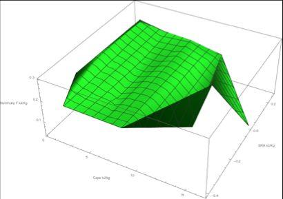
16 15

17 16 In all three graphs we observe sensitivity of the free energy density to the changes in values of CAPE and SRH. We also notice that for the heights when CAPE is small we have a stronger SRH taking over. Evolution of the Helmholtz free energy density in time results. We analyzed the information at 2 heights where CAPE was significant enough not to be sensitive to replacement of virtual temperature by actual temperature. h=1200m :
18 17 h=2500m : At h=1200m the slope is roughly.003 J/(Kg*s) which fits the lower end of the estimate for tornadic events by [2] quoted above. Future Plans: 1. To calculate the CAPE using precise virtual temperature to avoid distorted values at the low CAPE values 2. To refine the calculation for F(t) taking into consideration the updraft component of the flow 3. Evaluate additional parameters such as EHI, STP, LI and their ability to influence F(t) Bibliography: 1. C. A. Doswell, D. M. Schultz, On the Use of Indices and Parameters in Forecasting Severe Storms, E Journal of Severe Storms Meteorology, Vol. 3, No. 3, G. P. Bystrai, I. A. Lykov, S. A. Okhotnikov, Thermodynamics of nonequilibrium processes in a tornado: synergistic approach, 09/23/2011
19 Indices definitions from NOAA 4. Archived Meteorology from NOAA 5. Center for Analysis and Prediction of Storms 6. Extended Fujita Scale Appendix: Attached excel and mathematica files.
Using the Golden Ratio as a Model for Tornadogenesis. George McGivern Brad Walton Dr. Mikhail Shvartsman
 Using the Golden Ratio as a Model for Tornadogenesis George McGivern Brad Walton Dr. Mikhail Shvartsman 1. Introduction: Intro to tornadoes and tornado forecasting. Problem and Goals: The main problems
Tornadoes. tornado: a violently rotating column of air
 Tornadoes tornado: a violently rotating column of air Tornadoes What is the typical size of a tornado? What are typical wind speeds for a tornado? Five-stage life cycle of a tornado Dust Swirl Stage Tornado
MET Lecture 29 Tornadoes IV
 MET 4300 Lecture 29 Tornadoes IV Outline Definition, life cycle, & climatology of tornadoes Tornado formation within supercells Tornado formation within nonsupercell thunderstorms Fujita scale Tornado
Chapter 14 Thunderstorm Fundamentals
 Chapter overview: Thunderstorm appearance Thunderstorm cells and evolution Thunderstorm types and organization o Single cell thunderstorms o Multicell thunderstorms o Orographic thunderstorms o Severe
Tornadogenesis in Supercells: The Three Main Ingredients. Ted Funk
 Tornadogenesis in Supercells: The Three Main Ingredients Ted Funk NWS Louisville, KY Spring 2002 Environmental Parameters Supercells occur within environments exhibiting several wellknown characteristics
High-Resolution RUC CAPE Values and Their Relationship to Right Turning Supercells
 High-Resolution RUC CAPE Values and Their Relationship to Right Turning Supercells ANDREW H. MAIR Meteorology Program, Iowa State University, Ames, IA Mentor: Dr. William A. Gallus Jr. Department of Geological
Lab 21. Forecasting Extreme Weather: When and Under What Atmospheric Conditions Are Tornadoes Likely to Develop in the Oklahoma City Area?
 Forecasting Extreme Weather When and Under What Atmospheric Conditions Are Tornadoes Likely to Develop in the Oklahoma City Area? Lab Handout Lab 21. Forecasting Extreme Weather: When and Under What Atmospheric
III. Section 3.3 Vertical air motion can cause severe storms
 III. Section 3.3 Vertical air motion can cause severe storms http://www.youtube.com/watch?v=nxwbr60tflg&feature=relmfu A. Thunderstorms form from rising moist air Electrical charges build up near the tops
Hurricane and Tropical Cyclone Tornado Environments from RUC Proximity Soundings
 P8.1 Hurricane and Tropical Cyclone Tornado Environments from RUC Proximity Soundings Jonathan M. Davies* Private Meteorologist, Wichita, Kansas 1. Introduction Studies such as those by McCaul (1991, 1996)
Tornadoes forecasting, dynamics and genesis. Mteor 417 Iowa State University Week 12 Bill Gallus
 Tornadoes forecasting, dynamics and genesis Mteor 417 Iowa State University Week 12 Bill Gallus Tools to diagnose severe weather risks Definition of tornado: A vortex (rapidly rotating column of air) associated
Department of Earth & Climate Sciences Spring 2016 Meteorology 260
 Department of Earth & Climate Sciences Spring 2016 Meteorology 260 Name Laboratory #9 Key: Joplin Tornado Day Subsynoptic, Thermodynamic, and Wind Shear Setting Part A: 1600 UTC Surface Chart Subsynoptic
Department of Earth & Climate Sciences Spring 2016 Meteorology 260
 Department of Earth & Climate Sciences Spring 2016 Meteorology 260 Name Laboratory #9: Joplin Tornado Day Subsynoptic, Thermodynamic, and Wind Shear Setting Part A: 1600 UTC Surface Chart Subsynoptic Analyses
The Oakfield, Wisconsin, Tornado from July Brett Berenz Student at the University of Wisconsin
 The Oakfield, Wisconsin, Tornado from 18-19 July 1996 Brett Berenz Student at the University of Wisconsin Abstract On July 18 th, 1996 an F5 tornado affected the region of Oakfield, Wisconsin. Leading
Tornado Occurrences. Tornadoes. Tornado Life Cycle 4/12/17
 Chapter 19 Tornadoes Tornado Violently rotating column of air that extends from the base of a thunderstorm to the ground Tornado Statistics Over (100, 1000, 10000) tornadoes reported in the U.S. every
The Jarrell Tornado of May 27, 1997
 The Jarrell Tornado of May 27, 1997 ANDREW MANKOWSKI University of Wisconsin Madison Atmospheric and Oceanic Sciences ABSTRACT A tornado outbreak occurred over Central Texas on May 27, 1997. This outbreak
tornadoes in oklahoma Christi HAgen
 tornadoes in oklahoma Christi HAgen 17 Introduction Tornadoes are some of the world s most severe phenomena. They can be miles long, with wind speeds over two hundred miles per hour, and can develop in
Department of Geosciences San Francisco State University Spring Metr 201 Monteverdi Quiz #5 Key (100 points)
") Department of Geosciences Name San Francisco State University Spring 2012 Metr 201 Monteverdi Quiz #5 Key (100 points) 1. Fill in the Blank or short definition. (3 points each for a total of 15 points)
Department of Geosciences Name San Francisco State University Spring 2012 Metr 201 Monteverdi Quiz #5 Key (100 points) 1. Fill in the Blank or short definition. (3 points each for a total of 15 points)
WARM SECTOR TORNADOES WITHOUT DISCERNIBLE SURFACE BOUNDARIES AND WITH MINIMAL DEEP LAYER SHEA
 2.1 WARM SECTOR TORNADOES WITHOUT DISCERNIBLE SURFACE BOUNDARIES AND WITH MINIMAL DEEP LAYER SHEA * Joshua M. Boustead and Philip N. Schumacher National Weaer Service Sioux Falls, SD 1. INTRODUCTION On
Monteverdi Metr 201 Quiz #4 100 pts.
 DEPARTMENT OF GEOSCIENCES Name San Francisco State University April 27, 2012 Monteverdi Metr 201 Quiz #4 100 pts. A. Definitions. (5 points each for a total of 25 points in this section). (a) Convective
Comparison of Estimated and Observed Storm Motions to Environmental Parameters
 Comparison of Estimated and Observed Storm Motions to Environmental Parameters Eric Beamesderfer 1, 2, 3, 4, Kiel Ortega 3, 4, Travis Smith 3, 4, and John Cintineo 4, 5 1 National Weather Center Research
Weather Systems III: Thunderstorms and Twisters
 Weather Systems III: Thunderstorms and Twisters Review 1. Definition of airmasses? Bergeron classification of air masses 2. Surface weather analysis: Station model, wind speed code, present weather 3.
The perturbation pressure, p, can be represented as the sum of a hydrostatic pressure perturbation p h and a nonhydrostatic pressure perturbation p nh
 z = The perturbation pressure, p, can be represented as the sum of a hydrostatic pressure perturbation p h and a nonhydrostatic pressure perturbation p nh, that is, p = p h + p nh. (.1) The former arises
Chapter Introduction. Weather. Patterns. Forecasts Chapter Wrap-Up
 Chapter Introduction Lesson 1 Lesson 2 Lesson 3 Describing Weather Weather Patterns Weather Forecasts Chapter Wrap-Up How do scientists describe and predict weather? What do you think? Before you begin,
Advanced Spotter Training: Anticipating Severe Weather Threats. Professor Paul Sirvatka College of DuPage Meteorology
 Advanced Spotter Training: Anticipating Severe Weather Threats College of DuPage Meteorology Preparing for Severe Weather Preparedness involves understanding the probable and potential threats. Understanding
Oakfield, WI Tornado of July 18 th, 1996: "Everything in its Right Place"
 Oakfield, WI Tornado of July 18 th, 1996: "Everything in its Right Place" Arian Sarsalari Department of Atmospheric and Oceanic Sciences, University of Wisconsin Madison ABSTRACT This paper will serve
Jonathan M. Davies* Private Meteorologist, Wichita, Kansas
 4.3 RUC Soundings with Cool Season Tornadoes in Small CAPE Settings and the 6 November 2005 Evansville, Indiana Tornado Jonathan M. Davies* Private Meteorologist, Wichita, Kansas 1. Introduction Several
Charles A. Doswell III, Harold E. Brooks, and Robert A. Maddox
 Charles A. Doswell III, Harold E. Brooks, and Robert A. Maddox Flash floods account for the greatest number of fatalities among convective storm-related events but it still remains difficult to forecast
Determining Environmental Parameters Most Important for Significant Cool Season Tornadoes across the Gulf Coastal States
 Determining Environmental Parameters Most Important for Significant Cool Season Tornadoes across the Gulf Coastal States Kar retta Venable Jackson State University, Jackson, MS Mentors David Imy NOAA/NWS/NCEP/Storm
A Mesoscale Analysis of the March 29, 1998 Comfrey Tornado
 A Mesoscale Analysis of the March 29, 1998 Comfrey Tornado Joseph D. Hoechst Undergraduate Atmospheric and Oceanic Sciences University of Wisconsin Madison Email: hoechst@wisc.edu Department of Atmospheric
ASSESMENT OF THE SEVERE WEATHER ENVIROMENT IN NORTH AMERICA SIMULATED BY A GLOBAL CLIMATE MODEL
 JP2.9 ASSESMENT OF THE SEVERE WEATHER ENVIROMENT IN NORTH AMERICA SIMULATED BY A GLOBAL CLIMATE MODEL Patrick T. Marsh* and David J. Karoly School of Meteorology, University of Oklahoma, Norman OK and
Investigation of the Arizona Severe Weather Event of August 8 th, 1997
 Investigation of the Arizona Severe Weather Event of August 8 th, 1997 Tim Hollfelder May 10 th, 2006 Abstract Synoptic scale forcings were very weak for these thunderstorms on August 7-8, 1997 over the
Chapter 3 Convective Dynamics
 Chapter 3 Convective Dynamics Photographs Todd Lindley 3.2 Ordinary or "air-mass storm 3.2.1. Main Characteristics Consists of a single cell (updraft/downdraft pair) Forms in environment characterized
z g + F w (2.56) p(x, y, z, t) = p(z) + p (x, y, z, t) (2.120) ρ(x, y, z, t) = ρ(z) + ρ (x, y, z, t), (2.121)
 p(x, y, z, t) = p(z) + p (x, y, z, t) (2.120) ρ(x, y, z, t) = ρ(z) + ρ (x, y, z, t), (2.121)") = + dw dt = 1 ρ p z g + F w (.56) Let us describe the total pressure p and density ρ as the sum of a horizontally homogeneous base state pressure and density, and a deviation from this base state, that
= + dw dt = 1 ρ p z g + F w (.56) Let us describe the total pressure p and density ρ as the sum of a horizontally homogeneous base state pressure and density, and a deviation from this base state, that
Boundary-layer Decoupling Affects on Tornadoes
 Boundary-layer Decoupling Affects on Tornadoes Chris Karstens ABSTRACT The North American low-level jet is known to have substantial impacts on the climatology of central and eastern regions of the United
Environmental Characteristics Associated with Nighttime Tornadoes
 National Weather Association, Electronic Journal of Operational Meteorology, 2009-EJ3 Environmental Characteristics Associated with Nighttime Tornadoes Jonathan M. Davies Private Meteorologist, Trimble/Kansas
Investigating the Environment of the Indiana and Ohio Tornado Outbreak of 24 August 2016 Using a WRF Model Simulation 1.
 Investigating the Environment of the Indiana and Ohio Tornado Outbreak of 24 August 2016 Using a WRF Model Simulation Kevin Gray and Jeffrey Frame Department of Atmospheric Sciences, University of Illinois
4/18/2010. National Weather Service. Severe Weather Forecasting: A Western North Carolina Case Study
 National Weather Service Severe Weather Forecasting: A Western North Carolina Case Study Laurence G. Lee Science and Operations Officer National Weather Service Greer, SC Plus 13 River Forecast Centers
Analysis of Severe Storm Initiation Along Drylines in the Southern Plains
 Analysis of Severe Storm Initiation Along Drylines in the Southern Plains NICOLE L. BARBEE Meteorology Program, Iowa State University, Ames Mentor: Dr. William Gallus 1 1 Department of Geological and Atmospheric
Ki-Hong Min 1*, Seonhee Choo 2, and Gyuwon Lee 1, and Kyung-Eak Kim 1,3
 Ki-Hong Min 1*, Seonhee Choo 2, and Gyuwon Lee 1, and Kyung-Eak Kim 1,3 1 School of Earth System Sciences, Major in Atmospheric Science, Kyungpook National University, Daegu, South Korea 2 Forecast Technology
Ch. 3: Weather Patterns. Sect. 1: Air Mass & Fronts Sect. 2: Storms Sect. 3: Predicting the Weather
 Ch. 3: Weather Patterns Sect. 1: Air Mass & Fronts Sect. 2: Storms Sect. 3: Predicting the Weather Sect. 1: Air Masses & Fronts An air mass is a huge body of air that has similar temperature, humidity,
Practical Use of the Skew-T, log-p diagram for weather forecasting. Primer on organized convection
 Practical Use of the Skew-T, log-p diagram for weather forecasting Primer on organized convection Outline Rationale and format of the skew-t, log-p diagram Some basic derived diagnostic measures Characterizing
Large hail in Estonia on 12th August 2015
 Large hail in Estonia on 12th August 2015 Taimi Paljak, Velle Toll, Tanel Voormansik, Estonian Weather Service Introduction Hail is not as common in Northern Europe as in the rest of Europe due to the
THUNDERSTORMS Brett Ewing October, 2003
 THUNDERSTORMS Brett Ewing October, 2003 A natural hazard that occurs often on a daily basis in the lower and mid-latitudes is thunderstorms. Thunderstorms is a weather system that can produce lightning,tornadoes,
Illustrating Predictability for Nocturnal Tornado Events in the Southeastern United States
 1 2 3 4 5 6 7 8 9 10 11 12 13 14 15 16 17 18 19 20 21 22 23 24 25 26 27 28 29 30 31 32 33 34 35 36 37 38 39 40 41 Illustrating Predictability for Nocturnal Tornado Events in the Southeastern United States
P1.13 GROUND BASED REMOTELY SENSED HIGH TEMPORAL RESOLUTION STABILITY INDICES ASSOCIATED WITH SOUTHERN GREAT PLAINS TORNADO OUTBREAKS
 P1.13 GROUND BASED REMOTELY SENSED HIGH TEMPORAL RESOLUTION STABILITY INDICES ASSOCIATED WITH SOUTHERN GREAT PLAINS TORNADO OUTBREAKS Timothy J. Wagner*, Wayne F. Feltz, Ralph Petersen, Steven A. Ackerman
3A.6 ANALYSIS OF DATA FROM THE 2008 SUPER TUESDAY SEVERE WEATHER OUTBREAK: AN ARKANSAS PERSPECTIVE
 3A.6 ANALYSIS OF DATA FROM THE 2008 SUPER TUESDAY SEVERE WEATHER OUTBREAK: AN ARKANSAS PERSPECTIVE Christopher C. Buonanno* John A. Lewis III NOAA/NWS Little Rock AR 1. INTRODUCTION The Super Tuesday Severe
Your Task: Read each slide then use the underlined red or underlined information to fill in your organizer.
 Severe Weather: Tornadoes and Hurricanes Thunderstorms and Lightning S6E4 d. Construct an explanation of the relationship between air pressure, weather fronts, and air masses and meteorological events
STATISTICAL ANALYSIS ON SEVERE CONVECTIVE WEATHER COMBINING SATELLITE, CONVENTIONAL OBSERVATION AND NCEP DATA
 12.12 STATISTICAL ANALYSIS ON SEVERE CONVECTIVE WEATHER COMBINING SATELLITE, CONVENTIONAL OBSERVATION AND NCEP DATA Zhu Yaping, Cheng Zhoujie, Liu Jianwen, Li Yaodong Institute of Aviation Meteorology
Joshua M. Boustead *1, and Barbara E. Mayes NOAA/NWS WFO Omaha/Valley, NE. William Gargan, George Phillips, and Jared Leighton NOAA/NWS WFO Topeka, KS
 7B.3 Composite Analysis of Environmental Conditions Favorable for Significant Tornadoes across Eastern Kansas Joshua M. Boustead *1, and Barbara E. Mayes NOAA/NWS WFO Omaha/Valley, NE William Gargan, George
Severe Weather with a strong cold front: 2-3 April 2006 By Richard H. Grumm National Weather Service Office State College, PA 16803
 Severe Weather with a strong cold front: 2-3 April 2006 By Richard H. Grumm National Weather Service Office State College, PA 16803 1. INTRODUCTION A strong cold front brought severe weather to much of
P1.3 Tornadoes in a Deceptively Small CAPE Environment: The 4/20/04 Outbreak in Illinois and Indiana
 P1.3 Tornadoes in a Deceptively Small CAPE Environment: The 4/20/04 Outbreak in Illinois and Indiana Albert E. Pietrycha* Jonathan M. Davies #, Mark Ratzer*, and Paul Merzlock* *National Weather Service,
Tornado Probabilities Derived from Rapid Update Cycle Forecast Soundings
 Tornado Probabilities Derived from Rapid Update Cycle Forecast Soundings Zachary M. Byko National Weather Center Research Experiences for Undergraduates, and The Pennsylvania State University, University
Claim: Global warming is causing more and stronger tornadoes REBUTTAL
 Claim: Global warming is causing more and stronger tornadoes REBUTTAL Tornadoes are failing to follow global warming predictions. Strong tornadoes have seen a drop in frequency since the 1950s. The years
CHAPTER 13 WEATHER ANALYSIS AND FORECASTING MULTIPLE CHOICE QUESTIONS
 CHAPTER 13 WEATHER ANALYSIS AND FORECASTING MULTIPLE CHOICE QUESTIONS 1. The atmosphere is a continuous fluid that envelops the globe, so that weather observation, analysis, and forecasting require international
I. Convective Available Potential Energy (CAPE)
") Reading 4: Procedure Summary-- Calcluating CAPE, Lifted Index and Strength of Maximum Convective Updraft CAPE Calculation Lifted Index Calculation Maximum Updraft Strength Calculation I. Convective Available
Reading 4: Procedure Summary-- Calcluating CAPE, Lifted Index and Strength of Maximum Convective Updraft CAPE Calculation Lifted Index Calculation Maximum Updraft Strength Calculation I. Convective Available
P4.479 A DETAILED ANALYSIS OF SPC HIGH RISK OUTLOOKS,
 P4.479 A DETAILED ANALYSIS OF SPC HIGH RISK OUTLOOKS, 2003-2009 Jason M. Davis*, Andrew R. Dean 2, and Jared L. Guyer 2 Valparaiso University, Valparaiso, IN 2 NOAA/NWS Storm Prediction Center, Norman,
Thunderstorm Dynamics. Helicity and Hodographs and their effect on thunderstorm longevity. Bluestein Vol II. Page
 Thunderstorm Dynamics Helicity and Hodographs and their effect on thunderstorm longevity Bluestein Vol II. Page471-476. Dowsell, 1991: A REVIEW FOR FORECASTERS ON THE APPLICATION OF HODOGRAPHS TO FORECASTING
I. Convective Available Potential Energy (CAPE)
") Calculating CAPE, Lifted Index and Strength of Maximum Convective Updraft CAPE Calculation Lifted Index Calculation Maximum Updraft Strength Calculation I. Convective Available Potential Energy (CAPE)
Calculating CAPE, Lifted Index and Strength of Maximum Convective Updraft CAPE Calculation Lifted Index Calculation Maximum Updraft Strength Calculation I. Convective Available Potential Energy (CAPE)
Warm season forecasting! Some material adapted from Material Produced at COMET for their Residence Course in Hydrometeorology
 Warm season forecasting! Some material adapted from Material Produced at COMET for their Residence Course in Hydrometeorology 1 Outline! Types of stability and application to forecasting! Dry and moist
What Is the Weather Like in Different Regions of the United States?
 Learning Set 1 What Is Weather, and How Is It Measured and Described? 1.3 Explore What Is the Weather Like in Different Regions of the United States? trends: patterns or tendencies you can see over a broad
MET Lecture 34 Downbursts
 MET 4300 Lecture 34 Downbursts Downbursts A strong downdraft that originates within the lower part of a cumulus cloud or thunderstorms and spreads out at the surface Downbursts do not require strong thunderstorms
Proximity sounding analysis for derechos and supercells: an assessment of similarities and differences
 Atmospheric Research 67 68 (2003) 117 133 www.elsevier.com/locate/atmos Proximity sounding analysis for derechos and supercells: an assessment of similarities and differences Charles A. Doswell III a,
Pennsylvania Severe Weather of September 2016
 Pennsylvania Severe Weather of September 2016 By Richard H. Grumm National Weather Service State College, PA 1. Overview September 2016 was a relatively quiet month for severe weather across most of the
Module 11: Meteorology Topic 6 Content: Severe Weather Notes
 Severe weather can pose a risk to you and your property. Meteorologists monitor extreme weather to inform the public about dangerous atmospheric conditions. Thunderstorms, hurricanes, and tornadoes are
May 17, earthsciencechapter24.notebook. Apr 8 10:54 AM Review. Grade:9th. Subject:Earth Science. Date:4/8.
 Apr 8 10:54 AM 24.1 Review Grade:9th Subject:Earth Science Date:4/8 Apr 8 9:29 AM 1 1 As lower layers of air are warmed... A the air rises B winds form C the air dries D the air sinks Apr 8 9:49 AM 2 What
WISCONSIN TORNADO OUTBREAK OF 18 AUGUST 2005: AN EXAMINATION OF THE VIOLA, WISCONSIN TORNADO
 WISCONSIN TORNADO OUTBREAK OF 18 AUGUST 2005: AN EXAMINATION OF THE VIOLA, WISCONSIN TORNADO Charles D. Koch University of Wisconsin Madison AOS 453: Mesoscale Meteorology Professor Greg Tripoli 13 May
Type of storm viewed by Spotter A Ordinary, multi-cell thunderstorm. Type of storm viewed by Spotter B Supecell thunderstorm
 ANSWER KEY Part I: Locating Geographical Features 1. The National Weather Service s Storm Prediction Center (www.spc.noaa.gov) has issued a tornado watch on a warm spring day. The watch covers a large
The Earth System - Atmosphere III Convection
 The Earth System - Atmosphere III Convection Thunderstorms 1. A thunderstorm is a storm that produces lightning (and therefore thunder) 2. Thunderstorms frequently produce gusty winds, heavy rain, and
Impact of different cumulus parameterizations on the numerical simulation of rain over southern China
 Impact of different cumulus parameterizations on the numerical simulation of rain over southern China P.W. Chan * Hong Kong Observatory, Hong Kong, China 1. INTRODUCTION Convective rain occurs over southern
David O. Blanchard* and Brian A. Klimowski National Weather Service, Flagstaff, Arizona
 P12.1 SUPERCE EVOUTION IN ENVIRONMENTS WITH UNUSUA HODOGRAPHS David O. Blanchard* and Brian A. Klimowski National Weather Service, Flagstaff, Arizona 1. INTRODUCTION The events that transpired across northern
Solutions to Comprehensive Final Examination Given on Thursday, 13 December 2001
 Name & Signature Dr. Droegemeier Student ID Meteorology 1004 Introduction to Meteorology Fall, 2001 Solutions to Comprehensive Final Examination Given on Thursday, 13 December 2001 BEFORE YOU BEGIN!! Please
P3.17 THE DEVELOPMENT OF MULTIPLE LOW-LEVEL MESOCYCLONES WITHIN A SUPERCELL. Joshua M. Boustead *1 NOAA/NWS Weather Forecast Office, Topeka, KS
 P3.17 THE DEVELOPMENT OF MULTIPLE LOW-LEVEL MESOCYCLONES WITHIN A SUPERCELL Joshua M. Boustead *1 NOAA/NWS Weather Forecast Office, Topeka, KS Philip N. Schumacher NOAA/NWS Weather Forecaster Office, Sioux
The Greensburg, KS Tornado
 J2.4 The Greensburg, KS Tornado Daniel McCarthy NOAA Storm Prediction Center Norman, OK Larry Ruthi and Jeff Hutton NWS Weather Forecast Office Dodge City, KS 1. Background The tornado that moved through
P12.14 A SOUNDING-DERIVED CLIMATOLOGY OF SIGNIFICANT TORNADO EVENTS IN THE GREENVILLE-SPARTANBURG, SOUTH CAROLINA COUNTY WARNING AREA ( )
") P12.14 A SOUNDING-DERIVED CIMATOOGY OF SIGNIFICANT TORNADO EVENTS IN THE GREENVIE-SPARTANBURG, SOUTH CAROINA COUNTY WARNING AREA (1948-26) Justin D. ane* NOAA/National Weather Service Greer, South Carolina
P12.14 A SOUNDING-DERIVED CIMATOOGY OF SIGNIFICANT TORNADO EVENTS IN THE GREENVIE-SPARTANBURG, SOUTH CAROINA COUNTY WARNING AREA (1948-26) Justin D. ane* NOAA/National Weather Service Greer, South Carolina
Statistical Work and Predictability of Tornados. Misha Shvartsman Department of Mathematics University of St. Thomas
 Statistical Work and Predictability of Tornados Misha Shvartsman Department of Mathematics University of St. Thomas Statistical Work and Predictability of Tornados Tornado (violently rotating column of
Tornadoes and waterspouts in the Balearic Islands: phenomena and environment characterization
 Ž. Atmospheric Research 56 2001 www.elsevier.comrlocateratmos Tornadoes and waterspouts in the Balearic Islands: phenomena and environment characterization M. Gaya` a,), V. Homar b, R. Romero c, C. Ramis
COMMUNITY EMERGENCY RESPONSE TEAM TORNADOES
 Tornadoes are powerful, circular windstorms that may be accompanied by winds in excess of 200 miles per hour. Tornadoes typically develop during severe thunderstorms and may range in width from several
Tornadoes pose a high risk because the low atmospheric pressure, combined with high wind velocity, can:
 Tornadoes are powerful, circular windstorms that may be accompanied by winds in excess of 200 miles per hour. Tornadoes typically develop during severe thunderstorms and may range in width from several
Tornado Hazard Risk Analysis: A Report for Rutherford County Emergency Management Agency
 Tornado Hazard Risk Analysis: A Report for Rutherford County Emergency Management Agency by Middle Tennessee State University Faculty Lisa Bloomer, Curtis Church, James Henry, Ahmad Khansari, Tom Nolan,
Meteorology Lecture 19
 Meteorology Lecture 19 Robert Fovell rfovell@albany.edu 1 Important notes These slides show some figures and videos prepared by Robert G. Fovell (RGF) for his Meteorology course, published by The Great
5.0 WHAT IS THE FUTURE ( ) WEATHER EXPECTED TO BE?
 WEATHER EXPECTED TO BE?") 5.0 WHAT IS THE FUTURE (2040-2049) WEATHER EXPECTED TO BE? This chapter presents some illustrative results for one station, Pearson Airport, extracted from the hour-by-hour simulations of the future period
5.0 WHAT IS THE FUTURE (2040-2049) WEATHER EXPECTED TO BE? This chapter presents some illustrative results for one station, Pearson Airport, extracted from the hour-by-hour simulations of the future period
Module 11: Meteorology Topic 5 Content: Weather Maps Notes
 Introduction A variety of weather maps are produced by the National Weather Service and National Oceanographic Atmospheric Administration. These maps are used to help meteorologists accurately predict
Thunderstorms and Severe Weather. (Chapt 15)
") Thunderstorms and Severe Weather (Chapt 15) The Big Picture We ve emphasized horizontal transport of energy to balance the planetary energy budget: Hadley Cell Subtropical divergence Midlatitude cyclones
Thunderstorms and Severe Weather (Chapt 15) The Big Picture We ve emphasized horizontal transport of energy to balance the planetary energy budget: Hadley Cell Subtropical divergence Midlatitude cyclones
Thunderstorms. Stages in the development of a thunderstorm
 Severe Weather Outcomes: S2-4-04 Explain the formation and dynamics of selected severe weather phenomena... S2-4-05 Collect, interpret, and analyze meteorological data related to a severe weather event.
Atmospheric Moisture, Precipitation, and Weather Systems
 Atmospheric Moisture, Precipitation, and Weather Systems 6 Chapter Overview The atmosphere is a complex system, sometimes described as chaotic in nature. In this chapter we examine one of the principal
THE SEPTEMBER 24,1987, YUMA PROVING GROUND TORNADO
 Volume 14 Number February, 1989 13 THE SEPTEMBER 24,1987, YUMA PROVNG GROUND TORNADO Paul R. Vukits (1) ASL Yuma Met Team ABSTRACT Numerous reports of a tornado on the Yuma Proving Grounds (YPG), Arizona
Module 9 Weather Systems
 Module 9 Weather Systems In this module the theory of atmospheric dynamics is applied to different weather phenomena. The first section deals with extratropical cyclones, low and high pressure areas of
Section 13-1: Thunderstorms
 Section 13-1: Thunderstorms Chapter 13 Main Idea: The intensity and duration of thunderstorms depend on the local conditions that create them. Air-mass thunderstorm Mountain thunderstorm Sea-breeze thunderstorm
Extremes Seminar: Tornadoes
 Dec. 01, 2014 Outline Introduction 1 Introduction 2 3 4 Introduction 101: What is a tornado? According to the Glossary of Meteorology (AMS 2000), a tornado is a violently rotating column of air, pendant
April 13, 2006: Analysis of the Severe Thunderstorms that produced Hail in Southern Wisconsin
 April 13, 2006: Analysis of the Severe Thunderstorms that produced Hail in Southern Wisconsin Danielle Triolo UW Madison Undergraduate 453 Case Study May 5, 2009 ABSTRACT On April 13, 2006 the states of
Exploring Tornado Prediction with Neural Modeling
 DECISION SCIENCES INSTITUTE of Radar-Indicated Storm Features (Full Paper Submission) Trevor White Virginia Tech tsw90@vt.edu Tabitha L. James Virginia Tech tajames@vt.edu Deborah F. Cook Virginia Tech
Synoptic Environments Associated with Significant Tornadoes in the Contiguous United States
 Synoptic Environments Associated with Significant Tornadoes in the Contiguous United States JAYSON A. PRENTICE Department of Geological and Atmospheric Sciences, Iowa State University, Ames, IA Mentor:
Air Masses, Fronts & Storms
 Air Masses, Fronts & Storms Air Masses and Fronts Bell Work Define Terms (page 130-135) Vocab Word Definition Picture Air Mass A huge body of air that has smilier temperature, humidity and air pressure
June 7, 2008 Northeast Illinois Tornado Outbreak: Applying to Fundamentals in Storm Spotting
 June 7, 2008 Northeast Illinois Tornado Outbreak: Applying to Fundamentals in Storm Spotting Near Manhattan, IL Richton Park, IL Ricky Castro National Weather Service Chicago/Romeoville, IL Tornado Crossing
1st Tornado Photograph
 Lecture 26 Part II Tornados Environment Storm Structure Life Cycle Source of Spin Forecasting Climatology Damage Marilee Thomas of Beaver City, NE took this photograph of her daughter Audra about two miles
Thunderstorm: a cumulonimbus cloud or collection of cumulonimbus clouds featuring vigorous updrafts, precipitation and lightning
 Thunderstorm: a cumulonimbus cloud or collection of cumulonimbus clouds featuring vigorous updrafts, precipitation and lightning Thunderstorms are responsible for most of what we refer to as severe weather,
The 2015 NWS Spring and Summer Weather Update
 http://weather.gov The 2015 NWS Spring and Summer Weather Update Western North Carolina severe weather climatology Tony Sturey, WCM Greenville/Spartanburg, SC North Carolina Spring and Summer Outlooks
Thunderstorms. Thunderstorm Recipe
 Thunderstorms A thunderstorm is a storm with lightning and thunder. It's produced by a cumulonimbus cloud, usually producing gusty winds, heavy rain and sometimes hail. A typical thunderstorm is 15 miles
Analyzing Severe Weather Data
 Chapter Weather Patterns and Severe Storms Investigation A Analyzing Severe Weather Data Introduction Tornadoes are violent windstorms associated with severe thunderstorms. Meteorologists carefully monitor