Satellite Application Facility in Support to Operational Hydrology and Water Management - Soil Moisture -
|
|
|
- Irma Knight
- 6 years ago
- Views:
Transcription
 Vienna University of Technology (TU Wien) http://www.geo.tuwien.ac.")
1 Satellite Application Facility in Support to Operational Hydrology and Water Management - Soil Moisture - Wolfgang Wagner, Sebastian Hahn, Thomas Melzer, Mariette Vreugdenhil Department of Geodesy and Geoinformation (GEO) Vienna University of Technology (TU Wien)
2 Overview EUMETSAT H-SAF Satellites: METOP ASCAT Federated ground segment: The SAF Network Soil moisture remote sensing A vibrant research field Basic principles Sensors ASCAT surface soil moisture products Service specifications Data quality Value-added ASCAT soil moisture products
3 EUMETSAT H-SAF

4

5 METOP EUMETSAT s Polar-Orbiting Satellites METOP Satellite Series METOP-A METOP-B METOP-C Planned for October 2018 METOP Second Generation 2 x 3 satellites First launches in 2021 and 2022 Artistic view of METOP

6 METOP Display at EUMETSAT in Darmstadt

7 METOP Advanced Scatterometer (ASCAT) Sensor characteristics Active microwave scatterometer Frequency: C-band, GHz Polarisation: VV Spatial Resolution: 25 km/ 50 km Antennas: 2 x 3 Swath: 2 x 500 km Multi-incidence: Daily global coverage: 82 % Main applications Wind measurements, soil moisture, sea ice, freeze/thaw, vegetation dynamics

8

9
10 Soil Moisture Remote Sensing
 ) Air Water Average 1 Area Depth ( x, Area Depth y, z) dzdxdy Solid Particles Thin, remotely")
11 Soil Moisture Cross-section of a soil Definition, e.g. Water Volume Total Volume (m (m 3 3 ) ) Air Water Average 1 Area Depth ( x, Area Depth y, z) dzdxdy Solid Particles Thin, remotely sensed soil layer Root zone: layer of interest for most applications Soil profile
12 Approaches to Remote Sensing of Soil Moisture Measurement principles No direct measurement of possible, only indirect techniques Optical to Mid-Infrared (0.4 3 m) Change of colour Water absorption bands at 1.4, 1.9 and 2.7 m Thermal Infrared (7-15 m) Indirect assessment of soil moisture through its effect on the surface energy balance (temperature, thermal inertia, etc.) Microwaves (1 mm 1 m) Change of dielectric properties
13 Microwaves Microwaves (1 mm 1 m wavelength) All-weather, day-round measurement capability Very sensitive to soil water content below relaxation frequency of water (< 10 GHz) Penetrate vegetation and soil to some extent Penetration depth increases with wavelength The dipole moment of water molecules causes orientational polarisation, i.e. a high dielectric constant Dielectric constant of water
14 Measurement Principle Microwaves are highly sensitive to soil moisture due to the distinct dielectric properties of liquid water Observables Passive sensors: Brightness temperature T B = et s where e is the emissivity and T s is the surface temperature Active sensors: Backscattering coefficient 0 ; a measure of the reflectivity of the Earth surface Active measurements are somewhat more sensitive to roughness and vegetation structure than passive measurements, but are not affected by surface temperature (above 0 C) have a much better spatial resolution Despite these differences both active and passive sensors measure essentially the same variables: Passive and active methods are interrelated through Kirchhoff s law: e = 1 r where r is the reflectivity

15 Microwave Satellites used for Soil Moisture Retrieval

16 Backscatter from Vegetated Surfaces Except for dense forest canopies, backscatter from vegetation is due to surface-, volume- and multiple scattering 0 total 0 volume 0 surface 0 interaction Volume scattering Surface-volume interaction Surface scattering (attenuated by vegetation canopy)
 case")


17 Theoretical Backscatter Models Radiative transfer theory Modelling of bi-static scattering Mono-static backscatter as a special (simple) case Generalised phase functions for modelling surface-volume interactions Surface Scattering Exemplary Phase Functions for Vegetation Scattering Quast, R., W. Wagner (2016) An analytical solution for first-order scattering in bistatic radiative transfer interaction problems of layered media, Applied Optics, 55(20),
18 Backscattering Coefficient [db] Model Simulations Vegetation Optical Depth increases Incidence Angle [deg]
19 Soil Moisture Retrieval Empirical models Semi-empirical models Theoretical models Forward Model Y=f(X) Object Parameters X Sensor Observables Y Inversion X=g(Y) Lookup tables and neural networks Least-square matching Direct inversion


20 Why Model Calibration is Needed No model is all-encompassing Calibration is needed All natural systems models are to some degree lumped, and use effective parameters to characterize these spatial-temporal processes. Jasper Vrugt


21 Calibration Procedure The TU Wien processing architecture allows for calibration Per-pixel calibration is done - as far as possible - just based on historic satellite time series Auxiliary data are used for calibrating model parameters


22 Retrieval Procedure Retrieval can be performed in near-real-time and off-line Several algorithms can be used in parallel

23 SMAP Soil Moisture Image Composite of three days of SMAP radiometer data, centered on April 22, White areas indicate snow, ice or frozen ground. From
24 Limitations & Caveats Soil moisture retrieval is not possible over Urban areas, concrete and rock Water bodies and inundation Frozen or snow covered soil Under forests and dense shrubs Soil moisture data quality varies in space and time because of Vegetation water content and structure Sub-surface scattering in dry areas Topographic effects Temperature dependency (for passive only) Data quality described using uncertainty estimates (from error propagation) and advisory flags
25 Information Content

26 Information Content of Soil Moisture Retrievals Microwave sensors can provide information about spatio-temporal soil moisture trends Information about absolute values comes from external data sets Absolute values in soil moisture retrievals driven strongly by Used soil moisture maps Soil porosity, texture, etc. Surface roughness parameterization Not a geometric concept - use of effective roughness values - roughness depend on soil moisture Air-to-Soil Transition Model Schneeberger et al. (2004) Topsoil structure influencing soil water retrieval by microwave radiometry, Vadose Zone Journal, 3(4),
27 Signal versus Noise The information content of soil moisture is in our view best characterised by the signal-to-noise ratio (SNR) Key criterion in data assimilation Signal is tied to a certain scale Noise refers to random instrument noise as well as representativeness errors SNR is scale dependent Soil moisture scaling approaches Highly non-linear hydrological processes are assumed to linearize at coarse satellite scales Standard error model...satellite retrieval or model soil moisture ( )..."true"soil moisture state,... linear parameters... residual error
28 Triple Collocation Originally proposed to estimate random error variances Covariance-formulation ) ( ) ( ) ( Z Z Z Z Y Y Y Y X X X X 0 ), Cov( 0 ), Cov( j i i Assumptions: ), Cov( ), Cov( ), Cov( ), Cov( 1 Y Z Y X X Z Z Y Z X X Y X Error variances: Scaling coefficients: ), Cov( ), Cov( ), Cov( ) Var( ) Var( ), Cov( ), Cov( ), Cov( ) Var( ) Var( ), Cov( ), Cov( ), Cov( ) Var( ) Var( Y X Y Z X Z Z Z Z Z X Z Y X Y Y Y Y Z Y Z X Y X X X X j i Z Y X j i },, {, ) Var( ), Cov( ) Var( ) Var( ) Var( 2 2 j i j i i i i i Stoffelen, A. (1998). Toward the true near surface wind speed: Error modeling and calibration using triple collocation. Journal of Geophysical Research: Oceans ( ), 103(C4),
29 Triple Collocation Recently extended to estimate the signal-to-noise ratio SNR X Var( ) Var( ) i 1 Var( X ) Cov( Y, Z ) Cov(, ) Cov(, X Y X Z ) 1 i, j, k { X, Y, Z} i j k Draper, C., Reichle, R., de Jeu, R., Naeimi, V., Parinussa, R., & Wagner, W. (2013). Estimating root mean square errors in remotely sensed soil moisture over continental scale domains. Remote Sensing of Environment, 137, McColl, K. A., Vogelzang, J., Konings, A. G., Entekhabi, D., Piles, M., & Stoffelen, A. (2014). Extended triple collocation: Estimating errors and correlation coefficients with respect to an unknown target. Geophysical Research Letters.
![Signal to Noise Ratio More easy interpretabilty when expressed in decibel units SNR [db] 10log i Var( ) Var( ) i 0 db: signal variance = noise variance +/- 3 db: signal variance = double / half noise](/docs-images/76/73846779/images/30-2.jpg "variance Gruber, A., C. H. Su, S. Zwieback, W. Crow, W. Dorigo, W.")
30 Signal to Noise Ratio More easy interpretabilty when expressed in decibel units SNR [db] 10log i Var( ) Var( ) i 0 db: signal variance = noise variance +/- 3 db: signal variance = double / half noise variance Gruber, A., C. H. Su, S. Zwieback, W. Crow, W. Dorigo, W. Wagner (2016) Recent advances in (soil moisture) triple collocation analysis, International Journal of Applied Earth Observation and Geoinformation, 45,
 Triple collocation analysis of soil moisture from Metop-A ASCAT and SMOS against JRA-55 and ERA-Interim.")
31 SNR of ERA-Interim SNR of ASCAT & SMOS SNR of ASCAT SNR can be estimated with a large number of triplets Results are robust against exchange of model reference SNR of ASCAT SNR of SMOS Miyaoka et al. (2017) Triple collocation analysis of soil moisture from Metop-A ASCAT and SMOS against JRA-55 and ERA-Interim. IEEE Journal of Selected Topics in Applied Earth Observations and Remote Sensing, in press.
32 SNR as a Function of Vegetation Comparison of SNR for original soil moisture data sets (left), their climatology (middle) and anomalies (right). Unpublished preliminary results prepared by Alexander Gruber.
33 ASCAT Surface Soil Moisture
34 Scatterometer Soil Moisture Research


35 NRT 25 km ASCAT SM Service Evolution Was initiated as Day 2 product outside H-SAF on recommendation by Met Office and ECMWF to implement it more quickly, starting operations in 2008 Was brought into H-SAF in 2012 (start of CDOP2) Roles EUMETSAT NRT operations TU Wien R&D Delivery of model parameters for NRT processor ZAMG NRT testing chain
36 H SAF Surface Soil Moisture Products Near Real-time (NRT) products H16, H101-H103 are official H SAF soil moisture products produced by EUMETSAT (and re-distributed by H SAF under a different file name via FTP) H101: Metop-A ASCAT soil moisture at 12.5 km sampling H102: Metop-A ASCAT soil moisture at 25 km sampling H16: Metop-B ASCAT soil moisture at 12.5 km sampling H103: Metop-B ASCAT soil moisture at 25 km sampling H08 Disaggregated Metop ASCAT NRT SSM at 1 km Pre-operational Data records (DR) H25: Metop ASCAT DR2015 SSM time series 12.5 km sampling Released H109: Metop ASCAT DR2016 SSM time series 12.5 km sampling Released H111: Metop ASCAT DR2017 SSM time series 12.5 km sampling Under review H113: Metop ASCAT DR2018 SSM time series 12.5 km sampling Processed in Jan 2018 Offline products (regular extensions to data records) H108: Metop ASCAT DR2015 EXT SSM time series 12.5 km sampling Operational H110: Metop ASCAT DR2016 EXT SSM time series 12.5 km sampling Under review
 m t roughness and land cover s( ) 0 0 ( t) wet")
37 TU Wien Change Detection Approach Formulated in out of the need to circumvent the lack of adequate backscatter models 0 0 Accounts indirectly for surface t dry( t) m t roughness and land cover s( ) 0 0 ( t) wet dry t
38 TU Wien Backscatter Model Motivated by physical models and empirical evidence Formulated in decibels (db) domain Linear relationship between backscatter (in db) and soil moisture Empirical description of incidence angle behaviour Seasonal vegetation effects cancel each other out at the "cross-over angles" dependent on soil moisture Incidence angle behaviour is determined by vegetation and roughness roughness Changes due to soil moisture variations ERS Scatterometer measurements
39 Functional Behaviour The TU Wien backscatter model mimics a semi-empirical backscatter model with a strong surface-volume interaction term 0 = 1 f nt trcos 2 1 e 2 tr cos + s 0 e 2 tr cos + 2R 0 tr tr e 2 tr cos + f nt nt cos 2 Mixing model with fraction of non-transparent (nt) and transparent (tr) vegetation Bare soil scattering s 0 modelled with Improved Integral Equation Method I 2 EM Interaction term enhances soil moisture contributions

40 Calibration of cross-over angles Cross-over angle concept

41 Slope and Curvature: Metop-A vs Metop-B

42 Cross-over angle calibration & Dry/wet reference
 conditions respectively describes the signal response to soil moisture changes depends strongly on land")
43 Model Parameters: Sensitivity The sensitivity is an output of calibration procedures to estimate backscatter at (completely) dry and wet (saturated) conditions respectively describes the signal response to soil moisture changes depends strongly on land cover

44 Vegetation Optical Depth Using the Water Cloud model we can now retrieve VOD from the TU Wien backscatter model formulation as well VOD is a measure of how much the soil moisture signal is taken away by the vegetation layer τ = cosθ 2 ln Δσ 0 for bare soil Δσ 0 for vegetation covered soil Vreugdenhil et al. (2016) Analysing the Vegetation Parameterisation in the TU- Wien ASCAT Soil Moisture Retrieval, IEEE Transactions on Geoscience and Remote Sensing, 54(6),

45 ASCAT Vegetation Optical Depth
46 Global Vegetation Patterns a p CR LAI Mean values for τ a, τ p, CR and LAI

47 ASCAT Validation Metrics Until 2012: RMSE as for SMOS and SMAP : Correlation to external model data set From 2016: SNR applied to committed areas only Criteria since 2016 Criteria Mask Committed
 Global Models Local In Situ")

48 Soil Moisture from Models, In Situ and Satellites Field-Scale Model Global Satellite (ASCAT Test Product) Global Models Local In Situ Comparison of different soil moisture data sets over an agricultural region east of Vienna. S. Thaler, S. Hahn (manuscript in preparation)
49 Comparison of Short-Term Anomalies Field-Scale Model Field-Scale Model Global Model Global Satellite (ASCAT Test Product) Local In Situ
50 Comparison Against Mean Seasonal Signals


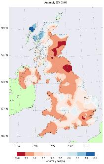
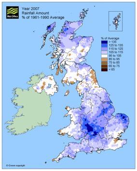
51 ASCAT Soil Moisture MetOffice Precipitation anomalies ( ) ASCAT Soil Moisture anomalies ( )
52 Soil Moisture, VOD and LAI Anomalies MetOffice weather summaries: 2007 very wet summer 2010 Very dry April, May June 2010/2011 Winter was dry and cold lot of snow 2011 Spring rainfall below normal over whole UK. Less than 1/3 of normal rainfall over southern and eastern England 2012 Summer Floods 2013/2014 Winter was wettest recorded since 1910

53 Inter-annual variability τ a LAI SM a Normalized yearly anomalies
54 Value-Added Soil Moisture Products

 0.")
55 ASCAT Soil Moisture Services Hydrology SAF Cooperation with EUMETSAT, ZAMG and ECMWF to deliver 25 km ASCAT surface soil moisture data in near-real-time Disaggregated 1 km ASCAT/ASAR soil moisture maps Assimilated ASCAT soil moisture profile Copernicus Global Land Cooperation with ZAMG and VITO to deliver CCI C3S Daily 25 km Soil Water Index (SWI) product based on H-SAF soil moisture data Evolution activity to produce 1km ASCAT/Sentinel-1 SWI data Cooperation with Vandersat, EODC and others to deliver Long-term (1978 up to present) 0.25 merged active/passive microwave soil moisture product International Soil Moisture Network Global data hosting facility for in situ soil moisture data
56 ASCAT Surface Soil Moisture

.")
57 Disaggregated 1 km ASCAT Surface Soil Moisture Resampling of 25 km data using a static downscaling method based on scaling parameters derived from SAR time series Left: 25 km ASCAT, right: 1 km downscaled surface soil moisture (DSSM). No-data values are masked and given a quality flag information.

58 Assimilated ASCAT Soil Moisture
59 Soil Water Index The SWI is an indicator of the profile soil moisture content The method rests upon simple differential model for describing the exchange of soil moisture between surface layer ( s ) and the reservoir () T characteristic time d 1 dt T s 1 T t t t T t texp dt s Thin, remotely sensed soil layer with s Root zone with : layer of interest for most applications Soil profile Wagner, W., G. Lemoine, H. Rott (1999) A Method for Estimating Soil Moisture from ERS Scatterometer and Soil Data, Remote Sensing of Environment, 70,

60 ASCAT Soil Water Index

61 ASCAT versus Model ASCAT versus 3 cm simulated degree of saturation for products, ms, SWI, and SWI* and investigated sites: a) Vallaccia, b) Cerbara, and c) Spoleto. Brocca, L., F. Melone, T. Moramarco, W. Wagner, S. Hasenauer (2010) ASCAT Soil Wetness Index validation through in-situ and modeled soil moisture data in Central Italy, Remote Sensing of Environment, in press.


62 1 km Sentinel-1 SM Data SSM1km on with ISMN stations used for validation


63 ASCAT - Sentinel-1 Fusion Scheme Sentinel-1 surface soil moisture Temporally sparse Fusion with ASCAT to produce daily profile Soil Water Index
 > 3200 registered users (status 25.")

 Prepared for BAMS State")
64 Soil Moisture Climate Data Record ESA Climate Change Initiative (CCI) > 3200 registered users (status ) Latest release: v03.2 on datasets: Merged active, merged passive, and combined active-passive Transfer to Copernicus Climate Change Service (C3S) Prepared for BAMS State of the Climate 2016

65 BAMS State of the Climate in 2015 Drier-than-average conditions were also evident over the global landmass. Soil moisture was below average for the entire year, and terrestrial groundwater storage was lower than at any other time during the record, which began in Areas in severe drought greatly increased, from 8% at the end of 2014 to 14% by the end of Yearly anomalies for selected variables in Extract of Plate 2.1 of BAMS State of the Climate 2015 report. Figure f shows soil moisture anomalies derived from ESA CCI soil moisture data set.
 Scientific users dominate, but already")

66 CCI Soil Moisture Data Users Already over 3200 users (status April 2017) Scientific users dominate, but already 20 % of all users come from public and commercial sector Application Domains Agriculture has grown by 2% in the past years
67 Conclusions Large number and high diversity of ASCAT soil moisture data users There is no one data product/service that can serve all user requirements Users must familiarise them with service specifications & data product characteristics ASCAT particularly interesting for operational users thanks to METOP-SG and EUMETSAT s long term vision on the SAFs Acknowledgements EUMETSAT: H-SAF CDOP2 and CDOP3 EU: Grant agreements no Earth2Observe and AdvancedSAR ESA: ESRIN Contract No /14/I-NG Phase 2 of CCI Soil Moisture Austrian Space Application Programme: EOP-Danube Austrian Science Fund: Vienna Doctoral Programme on Water Resources Systems
Microwave remote sensing of soil moisture and surface state
 Microwave remote sensing of soil moisture and surface state Wouter Dorigo wouter.dorigo@tuwien.ac.at Department of Geodesy and Geo-information, Vienna University of Technology, Vienna, Austria Microwave
Assimilation of satellite derived soil moisture for weather forecasting
 Assimilation of satellite derived soil moisture for weather forecasting www.cawcr.gov.au Imtiaz Dharssi and Peter Steinle February 2011 SMOS/SMAP workshop, Monash University Summary In preparation of the
Soil moisture Product and science update
 Soil moisture Product and science update Wouter Dorigo and colleagues Department of Geodesy and Geo-information, Vienna University of Technology, Vienna, Austria 2 June 2013 Soil moisture is getting mature
Drought Monitoring with Hydrological Modelling
 st Joint EARS/JRC International Drought Workshop, Ljubljana,.-5. September 009 Drought Monitoring with Hydrological Modelling Stefan Niemeyer IES - Institute for Environment and Sustainability Ispra -
Evaluation of remotely sensed and modelled soil moisture products using global ground-based in situ observations
 Evaluation of remotely sensed and modelled soil moisture products using global ground-based in situ observations C. Albergel (1), P. de Rosnay (1), G. Balsamo (1),J. Muñoz-Sabater(1 ), C. Gruhier (2),
ECMWF. ECMWF Land Surface Analysis: Current status and developments. P. de Rosnay M. Drusch, K. Scipal, D. Vasiljevic G. Balsamo, J.
 Land Surface Analysis: Current status and developments P. de Rosnay M. Drusch, K. Scipal, D. Vasiljevic G. Balsamo, J. Muñoz Sabater 2 nd Workshop on Remote Sensing and Modeling of Surface Properties,
ASCAT-B Level 2 Soil Moisture Validation Report
 EUMETSAT EUMETSAT Allee 1, D-64295 Darmstadt, Doc.No. : EUM/OPS/DOC/12/3849 Germany Tel: +49 6151 807-7 Issue : v2 Fax: +49 6151 807 555 Date : 20 December 2012 http://www.eumetsat.int Page 1 of 25 This
IEEE TRANSACTIONS ON GEOSCIENCE AND REMOTE SENSING 1
 IEEE TRANSACTIONS ON GEOSCIENCE AND REMOTE SENSING 1 Triple Collocation-Based Merging of Satellite Soil Moisture Retrievals Alexander Gruber, Wouter Arnoud Dorigo, Wade Crow, and Wolfgang Wagner, Senior
Land Data Assimilation for operational weather forecasting
 Land Data Assimilation for operational weather forecasting Brett Candy Richard Renshaw, JuHyoung Lee & Imtiaz Dharssi * *Centre Australian Weather and Climate Research Contents An overview of the Current
SOIL MOISTURE PRODUCTS FROM C-BAND SCATTEROMETERS: FROM ERS-1/2 TO METOP
 1 SOIL MOISTURE PRODUCTS FROM C-BAND SCATTEROMETERS: FROM ERS-1/2 TO METOP Zoltan Bartalis, Klaus Scipal, Wolfgang Wagner I.P.F. - Insitute of Photogrammetry and Remote Sensing, Vienna University of Technology,
ECMWF. ECMWF Land Surface modelling and land surface analysis. P. de Rosnay G. Balsamo S. Boussetta, J. Munoz Sabater D.
 Land Surface modelling and land surface analysis P. de Rosnay G. Balsamo S. Boussetta, J. Munoz Sabater D. Vasiljevic M. Drusch, K. Scipal SRNWP 12 June 2009 Slide 1 Surface modelling (G. Balsamo) HTESSEL,
Algorithm Theoretical Baseline Document (ATBD) Surface Soil Moisture ASCAT NRT Orbit
 Surface Soil Moisture ASCAT NRT Orbit") Page: 1/16 EUMETSAT Satellite Application Facility on Support to Operational Hydrology and Water Management H101, H102, H16, H103, H106, H107 Page: 2/16 Revision History Revision Date Author(s) Description
Page: 1/16 EUMETSAT Satellite Application Facility on Support to Operational Hydrology and Water Management H101, H102, H16, H103, H106, H107 Page: 2/16 Revision History Revision Date Author(s) Description
European High-Resolution Soil Moisture Analysis (EHRSOMA)
") European High-Resolution Soil Moisture Analysis (EHRSOMA) Jasmin Vural EUMETSAT Fellow Day, 05.03.2018 European High-Resolution Soil Moisture Analysis (EHRSOMA) Jasmin Vural EUMETSAT Fellow Day, 05.03.2018
European High-Resolution Soil Moisture Analysis (EHRSOMA) Jasmin Vural EUMETSAT Fellow Day, 05.03.2018 European High-Resolution Soil Moisture Analysis (EHRSOMA) Jasmin Vural EUMETSAT Fellow Day, 05.03.2018
Assimilation of land surface satellite data for Numerical Weather Prediction at ECMWF
 4 th workshop on Remote Sensing and Modelling of Surface properties Saint Martin d Hères, 14-16 March 2016 Assimilation of land surface satellite data for Numerical Weather Prediction at ECMWF P. de Rosnay,
Advancing Remote-Sensing Methods for Monitoring Geophysical Parameters
 Advancing Remote-Sensing Methods for Monitoring Geophysical Parameters Christian Mätzler (Retired from University of Bern) Now consultant for Gamma Remote Sensing, Switzerland matzler@iap.unibe.ch TERENO
H SAF SATELLITE APPLICATION FACILITY ON SUPPORT TO OPERATIONAL HYDROLOGY AND WATER MANAGEMENT EUMETSAT NETWORK OF SATELLITE APPLICATION FACILITIES
 H SAF SATELLITE APPLICATION FACILITY ON SUPPORT TO OPERATIONAL HYDROLOGY AND WATER MANAGEMENT EUMETSAT NETWORK OF SATELLITE APPLICATION FACILITIES H-SAF: SATELLITE PRODUCTS FOR OPERATIONAL HYDROLOGY H-SAF
Julia Figa-Saldaña & Klaus Scipal
 Julia Figa-Saldaña & Klaus Scipal julia.figa@eumetsat.int klaus.scipal@esa.int Meeting, Outline MetOp/EPS status MetOp/EPS Second Generation status 2016 scatterometer conference Other European ocean programme
Evaluation strategies of coarse resolution SM products for monitoring deficit/excess conditions in the Pampas Plains, Argentina
 Evaluation strategies of coarse resolution SM products for monitoring deficit/excess conditions in the Pampas Plains, Argentina Francisco Grings, Cintia Bruscantini, Federico Carballo, Ezequiel Smucler,
Assimilation of ASCAT soil wetness
 EWGLAM, October 2010 Assimilation of ASCAT soil wetness Bruce Macpherson, on behalf of Imtiaz Dharssi, Keir Bovis and Clive Jones Contents This presentation covers the following areas ASCAT soil wetness
Long term performance monitoring of ASCAT-A
 Long term performance monitoring of ASCAT-A Craig Anderson and Julia Figa-Saldaña EUMETSAT, Eumetsat Allee 1, 64295 Darmstadt, Germany. Abstract The Advanced Scatterometer (ASCAT) on the METOP series of
THE POTENTIAL OF SENTINEL-1 FOR MONITORING SOIL MOISTURE WITH A HIGH SPATIAL RESOLUTION AT GLOBAL SCALE
 THE POTENTIAL OF SENTINEL-1 FOR MONITORING SOIL MOISTURE WITH A HIGH SPATIAL RESOLUTION AT GLOBAL SCALE Wolfgang Wagner, Daniel Sabel, Marcela Doubkova, Annett Bartsch, Carsten Pathe Institute of Photogrammetry
EUMETSAT SAF NETWORK. Lothar Schüller, EUMETSAT SAF Network Manager
 1 EUMETSAT SAF NETWORK Lothar Schüller, EUMETSAT SAF Network Manager EUMETSAT ground segment overview METEOSAT JASON-2 INITIAL JOINT POLAR SYSTEM METOP NOAA SATELLITES CONTROL AND DATA ACQUISITION FLIGHT
EUMETSAT STATUS AND PLANS
 1 EUM/TSS/VWG/15/826793 07/10/2015 EUMETSAT STATUS AND PLANS François Montagner, Marine Applications Manager, EUMETSAT WMO Polar Space Task Group 5 5-7 October 2015, DLR, Oberpfaffenhofen PSTG Strategic
Toward improving the representation of the water cycle at High Northern Latitudes
 Toward improving the representation of the water cycle at High Northern Latitudes W. A. Lahoz a, T. M. Svendby a, A. Griesfeller a, J. Kristiansen b a NILU, Kjeller, Norway b Met Norway, Oslo, Norway wal@nilu.no
Assimilation of passive and active microwave soil moisture retrievals
 GEOPHYSICAL RESEARCH LETTERS, VOL. 39,, doi:10.1029/2011gl050655, 2012 Assimilation of passive and active microwave soil moisture retrievals C. S. Draper, 1,2 R. H. Reichle, 1 G. J. M. De Lannoy, 1,2,3
SMAP and SMOS Integrated Soil Moisture Validation. T. J. Jackson USDA ARS
 SMAP and SMOS Integrated Soil Moisture Validation T. J. Jackson USDA ARS Perspective Linkage of SMOS and SMAP soil moisture calibration and validation will have short and long term benefits for both missions.
Climate data records from OSI SAF scatterometer winds. Anton Verhoef Jos de Kloe Jeroen Verspeek Jur Vogelzang Ad Stoffelen
 Climate data records from OSI SAF scatterometer winds Anton Verhoef Jos de Kloe Jeroen Verspeek Jur Vogelzang Ad Stoffelen Outline Motivation Planning Preparation and methods Quality Monitoring Output
CLIMATE CHANGE AND REGIONAL HYDROLOGY ACROSS THE NORTHEAST US: Evidence of Changes, Model Projections, and Remote Sensing Approaches
 CLIMATE CHANGE AND REGIONAL HYDROLOGY ACROSS THE NORTHEAST US: Evidence of Changes, Model Projections, and Remote Sensing Approaches Michael A. Rawlins Dept of Geosciences University of Massachusetts OUTLINE
ASCAT Soil Moisture: An Assessment of the Data Quality and Consistency with the ERS Scatterometer Heritage
 APRIL 2009 N A E I M I E T A L. 555 ASCAT Soil Moisture: An Assessment of the Data Quality and Consistency with the ERS Scatterometer Heritage VAHID NAEIMI, ZOLTAN BARTALIS, AND WOLFGANG WAGNER Institute
Land data assimilation in the NASA GEOS-5 system: Status and challenges
 Blueprints for Next-Generation Data Assimilation Systems Boulder, CO, USA 8-10 March 2016 Land data assimilation in the NASA GEOS-5 system: Status and challenges Rolf Reichle Clara Draper, Ricardo Todling,
972 IEEE GEOSCIENCE AND REMOTE SENSING LETTERS, VOL. 13, NO. 7, JULY High-Resolution Soil Moisture Retrieval With ASCAT
 972 IEEE GEOSCIENCE AND REMOTE SENSING LETTERS, VOL. 13, NO. 7, JULY 216 High-Resolution Soil Moisture Retrieval With ASCAT David B. Lindell, Student Member, IEEE, and David G. Long, Fellow, IEEE Abstract
Satellite Soil Moisture in Research Applications
 Satellite Soil Moisture in Research Applications Richard de Jeu richard.de.jeu@falw.vu.nl Thomas Holmes, Hylke Beck, Guojie Wang, Han Dolman (VUA) Manfred Owe (NASA-GSFC) Albert Van Dijk, Yi Liu (CSIRO)
Snow Cover Applications: Major Gaps in Current EO Measurement Capabilities
 Snow Cover Applications: Major Gaps in Current EO Measurement Capabilities Thomas NAGLER ENVEO Environmental Earth Observation IT GmbH INNSBRUCK, AUSTRIA Polar and Snow Cover Applications User Requirements
Use of satellite soil moisture information for NowcastingShort Range NWP forecasts
 Use of satellite soil moisture information for NowcastingShort Range NWP forecasts Francesca Marcucci1, Valerio Cardinali/Paride Ferrante1,2, Lucio Torrisi1 1 COMET, Italian AirForce Operational Center
Stability in SeaWinds Quality Control
 Ocean and Sea Ice SAF Technical Note Stability in SeaWinds Quality Control Anton Verhoef, Marcos Portabella and Ad Stoffelen Version 1.0 April 2008 DOCUMENTATION CHANGE RECORD Reference: Issue / Revision:
A two-season impact study of the Navy s WindSat surface wind retrievals in the NCEP global data assimilation system
 A two-season impact study of the Navy s WindSat surface wind retrievals in the NCEP global data assimilation system Li Bi James Jung John Le Marshall 16 April 2008 Outline WindSat overview and working
Evaluation of a Global Soil Moisture Product from Finer Spatial Resolution SAR Data and Ground Measurements at Irish Sites
 Remote Sens. 2014, 6, 8190-8219; doi:10.3390/rs6098190 Article OPEN ACCESS remote sensing ISSN 2072-4292 www.mdpi.com/journal/remotesensing Evaluation of a Global Soil Moisture Product from Finer Spatial
High resolution land reanalysis
 Regional Reanalysis Workshop 19-20 May 2016, Reading High resolution land reanalysis P. de Rosnay, G. Balsamo, J. Muñoz Sabater, E. Dutra, C. Albergel, N. Rodríguez-Fernández, H. Hersbach Introduction:
Product User Manual (PUM) Surface Soil Moisture ASCAT NRT Orbit
 Surface Soil Moisture ASCAT NRT Orbit") Page: 1/20 EUMETSAT Satellite Application Facility on Support to Operational Hydrology and Water Management Product User Manual (PUM) H101, H102, H16, H103 Page: 2/20 Revision History Revision Date Author(s)
Page: 1/20 EUMETSAT Satellite Application Facility on Support to Operational Hydrology and Water Management Product User Manual (PUM) H101, H102, H16, H103 Page: 2/20 Revision History Revision Date Author(s)
From L1 to L2 for sea ice concentration. Rasmus Tonboe Danish Meteorological Institute EUMETSAT OSISAF
 From L1 to L2 for sea ice concentration Rasmus Tonboe Danish Meteorological Institute EUMETSAT OSISAF Sea-ice concentration = sea-ice surface fraction Water Ice e.g. Kern et al. 2016, The Cryosphere
Observation Operators for sea ice thickness to L-band brightness temperatures
 Observation Operators for sea ice thickness to L-band brightness temperatures F. Richter, M. Drusch, L. Kaleschke, N. Maass, X. Tian-Kunze, G. Heygster, S. Mecklenburg, T. Casal, and many others ESA, ESTEC
FREEZE/THAW DETECTION IN PERMAFROST REGION WITH C-BAND SCATTEROMETERS
 FREEZE/THAW DETECTION IN PERMAFROST REGION WITH C-BAND SCATTEROMETERS Vahid Naeimi (1,2), Christoph Paulik (2), Wolfgang Wagner (2), Annett Bartsch (2) (1) German Remote Sensing Data Center (DFD-LA), German
Implementation Plan for a Soil Moisture Product for NWP
 ASCAT Soil Moisture Report Series No. 5 Implementation Plan for a Soil Moisture Product for NWP 2005 December 5 0 Status: Issue 1.2 Authors: IPF TU Wien (WW) Circulation: IPF, NWP SAF, Eumetsat Amendments:
Land Data Assimilation and the (Coordinated) National Soil Moisture Network
 National Soil Moisture Network") Land Data Assimilation and the (Coordinated) National Soil Moisture Network Wade Crow USDA ARS Hydrology and Remote Sensing Laboratory Alexander Gruber, Wouter Dorigo TU-Wien, Department of Geodesy and
Land Data Assimilation and the (Coordinated) National Soil Moisture Network Wade Crow USDA ARS Hydrology and Remote Sensing Laboratory Alexander Gruber, Wouter Dorigo TU-Wien, Department of Geodesy and
OSI SAF Sea Ice products
 OSI SAF Sea Ice products Lars-Anders Brevik, Gorm Dybkjær, Steinar Eastwood, Øystein Godøy, Mari Anne Killie, Thomas Lavergne, Rasmus Tonboe, Signe Aaboe Norwegian Meteorological Institute Danish Meteorological
EUMETSAT SAF NETWORK. Lothar Schüller, EUMETSAT SAF Network Manager
 1 EUMETSAT SAF NETWORK Lothar Schüller, EUMETSAT SAF Network Manager EUMETSAT ground segment overview METEOSAT JASON-2 INITIAL JOINT POLAR SYSTEM METOP NOAA SATELLITES CONTROL AND DATA ACQUISITION FLIGHT
IMPORTANCE OF SATELLITE DATA (FOR REANALYSIS AND BEYOND) Jörg Schulz EUMETSAT
 Jörg Schulz EUMETSAT") IMPORTANCE OF SATELLITE DATA (FOR REANALYSIS AND BEYOND) Jörg Schulz EUMETSAT Why satellite data for climate monitoring? Global coverage Global consistency, sometimes also temporal consistency High spatial
IMPORTANCE OF SATELLITE DATA (FOR REANALYSIS AND BEYOND) Jörg Schulz EUMETSAT Why satellite data for climate monitoring? Global coverage Global consistency, sometimes also temporal consistency High spatial
Next generation of EUMETSAT microwave imagers and sounders: new opportunities for cloud and precipitation retrieval
 Next generation of EUMETSAT microwave imagers and sounders: new opportunities for cloud and precipitation retrieval Christophe Accadia, Sabatino Di Michele, Vinia Mattioli, Jörg Ackermann, Sreerekha Thonipparambil,
Merged sea-ice thickness product from complementary L-band and altimetry information
 Merged sea-ice thickness product from complementary L-band and altimetry information Contributors AWI Team Stefan Hendricks Robert Ricker Stephan Paul University Hamburg Team Lars Kaleschke Xiangshan Tian-Kunze
Ocean Vector Winds in Storms from the SMAP L-Band Radiometer
 International Workshop on Measuring High Wind Speeds over the Ocean 15 17 November 2016 UK Met Office, Exeter Ocean Vector Winds in Storms from the SMAP L-Band Radiometer Thomas Meissner, Lucrezia Ricciardulli,
EUMETSAT Climate Activities
 EUMETSAT Climate Activities Jörg Schulz EUMETSAT s Role in Climate Monitoring EUMETSAT has a prominent role in the world for providing services relevant to climate: EUMETSAT maintains some of the longest
Soil frost from microwave data. Kimmo Rautiainen, Jouni Pulliainen, Juha Lemmetyinen, Jaakko Ikonen, Mika Aurela
 Soil frost from microwave data Kimmo Rautiainen, Jouni Pulliainen, Juha Lemmetyinen, Jaakko Ikonen, Mika Aurela Why landscape freeze/thaw? Latitudinal variation in mean correlations (r) between annual
Julia Figa-Saldaña & Klaus Scipal
 Julia Figa-Saldaña & Klaus Scipal julia.figa@eumetsat.int klaus.scipal@esa.int C. Anderson, F. Fois, C. Lin, M. Loiselet, F. Ticconi, J.J.W. Wilson Meeting, Outline Overview and objectives of European
C o p e r n i c u s L a n d M o n i t o r i n g S e r v i c e
 C o p e r n i c u s L a n d M o n i t o r i n g S e r v i c e Integration into existing Snow and Ice Services and draft product specifications Annett BARTSCH b.geos Copernicus High Resolution Snow and
Remote sensing of sea ice
 Remote sensing of sea ice Ice concentration/extent Age/type Drift Melting Thickness Christian Haas Remote Sensing Methods Passive: senses shortwave (visible), thermal (infrared) or microwave radiation
Instrumentation planned for MetOp-SG
 Instrumentation planned for MetOp-SG Bill Bell Satellite Radiance Assimilation Group Met Office Crown copyright Met Office Outline Background - the MetOp-SG programme The MetOp-SG instruments Summary Acknowledgements:
C o p e r n i c u s a n d W I G O S
 C o p e r n i c u s a n d W I G O S Jean-Noël Thépaut & Mark Dowell 24 October 2017 GEO XIV, Washington DC, 23-28 October 2017 T h e C o p e r n i c u s P r o g r a m m e Copernicus is the European Union
SIMULATION OF SPACEBORNE MICROWAVE RADIOMETER MEASUREMENTS OF SNOW COVER FROM IN-SITU DATA AND EMISSION MODELS
 SIMULATION OF SPACEBORNE MICROWAVE RADIOMETER MEASUREMENTS OF SNOW COVER FROM IN-SITU DATA AND EMISSION MODELS Anna Kontu 1 and Jouni Pulliainen 1 1. Finnish Meteorological Institute, Arctic Research,
SOIL MOISTURE FROM SATELLITE: A COMPARISON OF METOP, SMOS AND ASAR PRODUCTS
 SOIL MOISTURE FROM SATELLITE: A COMPARISON OF METOP, SMOS AND ASAR PRODUCTS Nazzareno Pierdicca 1, Luca Pulvirenti 1, Fabio Fascetti 1, Raffaele Crapolicchio 2,3, Marco Talone 2, Silvia Puca 4 1 Dept.
Dual-Frequency Ku- Band Radar Mission Concept for Snow Mass
 Dual-Frequency Ku- Band Radar Mission Concept for Snow Mass Chris Derksen Environment and Climate Change Canada Study Team: Climate Research Division/Meteorological Research Division, ECCC Canadian Space
WMO RA VI Hydrological Forum. H-SAF: from products to end users
 WMO RA VI Hydrological Forum Oslo, 20 September 2016 H-SAF: from products to end users Lt. Col. Francesco Zauli ITAF-COMet H-SAF Project Manager 1 H-SAF Objectives Satellite Application Facility in Support
Experiences of using ECV datasets in ECMWF reanalyses including CCI applications. David Tan and colleagues ECMWF, Reading, UK
 Experiences of using ECV datasets in ECMWF reanalyses including CCI applications David Tan and colleagues ECMWF, Reading, UK Slide 1 Main points Experience shows benefit of integrated & iterative approach
Global SWE Mapping by Combining Passive and Active Microwave Data: The GlobSnow Approach and CoReH 2 O
 Global SWE Mapping by Combining Passive and Active Microwave Data: The GlobSnow Approach and CoReH 2 O April 28, 2010 J. Pulliainen, J. Lemmetyinen, A. Kontu, M. Takala, K. Luojus, K. Rautiainen, A.N.
The NASA Soil Moisture Active Passive Mission (SMAP) Status and Early Results
 Status and Early Results") 20154 California Institute of Technology. Government sponsorship acknowledged. National Aeronautics and Space Administration The NASA Soil Moisture Active Passive Mission (SMAP) Status and Early Results
20154 California Institute of Technology. Government sponsorship acknowledged. National Aeronautics and Space Administration The NASA Soil Moisture Active Passive Mission (SMAP) Status and Early Results
Copernicus Space Component Status & Evolution
 Copernicus Space Component Status & Evolution ESCAP, Bangkok 09 October 2017 Simon Jutz Head of the ESA Copernicus Space Office Directorate of Earth Observation Programmes 28 satellites in development
ASCAT - Metop A developments, Metop B preparations & EPS-SG
 ASCAT - Metop A developments, Metop B preparations & EPS-SG Hans Bonekamp, Craig Anderson, Julia Figa & Julian Wilson Slide: 1 ASCAT Metop A - overview Instrument operating nominally (minor incident in
Studying snow cover in European Russia with the use of remote sensing methods
 40 Remote Sensing and GIS for Hydrology and Water Resources (IAHS Publ. 368, 2015) (Proceedings RSHS14 and ICGRHWE14, Guangzhou, China, August 2014). Studying snow cover in European Russia with the use
The Application of Satellite Data i n the Global Surface Data Assimil ation System at KMA
 The Application of Satellite Data i n the Global Surface Data Assimil ation System at KMA Mee-Ja Kim, Hae-Mi Noh, SeiYoung Park, Sangwon Joo KMA/NIMS kimmee74@korea.kr 14 March, 2016 The 4th Workshop on
Sentinel-3A Product Notice STM L2 Marine (NRT, STC and NTC)
") Sentinel-3A Product Notice STM L2 Marine (NRT, STC and NTC) Mission Sensor Product S3-A SRAL/MWR L2 NRT STC and NTC (Marine Products) Product Notice ID S3A.PN-STM-L2M.01 EUM/OPS-SEN3/DOC/16/893228 Issue
Sentinel-3A Product Notice STM L2 Marine (NRT, STC and NTC) Mission Sensor Product S3-A SRAL/MWR L2 NRT STC and NTC (Marine Products) Product Notice ID S3A.PN-STM-L2M.01 EUM/OPS-SEN3/DOC/16/893228 Issue
Land surface data assimilation for Numerical Weather Prediction
 Sixth WMO Symposium on Data Assimilation, University of Maryland, 7-11 October 2013 Land surface data assimilation for Numerical Weather Prediction P. de Rosnay, J. Muñoz Sabater, C. Albergel, G. Balsamo,
Towards the use of SAR observations from Sentinel-1 to study snowpack properties in Alpine regions
 Towards the use of SAR observations from Sentinel-1 to study snowpack properties in Alpine regions Gaëlle Veyssière, Fatima Karbou, Samuel Morin et Vincent Vionnet CNRM-GAME /Centre d Etude de la Neige
C. Jimenez, C. Prigent, F. Aires, S. Ermida. Estellus, Paris, France Observatoire de Paris, France IPMA, Lisbon, Portugal
 All-weather land surface temperature estimates from microwave satellite observations, over several decades and real time: methodology and comparison with infrared estimates C. Jimenez, C. Prigent, F. Aires,
Current status of lake modelling and initialisation at ECMWF
 Current status of lake modelling and initialisation at ECMWF G Balsamo, A Manrique Suñen, E Dutra, D. Mironov, P. Miranda, V Stepanenko, P Viterbo, A Nordbo, R Salgado, I Mammarella, A Beljaars, H Hersbach
OSI SAF Sea Ice Products
 OSI SAF Sea Ice Products Steinar Eastwood, Matilde Jensen, Thomas Lavergne, Gorm Dybkjær, Signe Aaboe, Rasmus Tonboe, Atle Sørensen, Jacob Høyer, Lars-Anders Breivik, RolfHelge Pfeiffer, Mari Anne Killie
Aquarius/SAC-D Soil Moisture Product using V3.0 Observations
 Aquarius/SAC-D Soil Moisture Product using V3. Observations R. Bindlish, T. Jackson, M. Cosh November 214 Overview Soil moisture algorithm Soil moisture product Validation Linkage between Soil Moisture
SEA ICE MICROWAVE EMISSION MODELLING APPLICATIONS
 SEA ICE MICROWAVE EMISSION MODELLING APPLICATIONS R. T. Tonboe, S. Andersen, R. S. Gill Danish Meteorological Institute, Lyngbyvej 100, DK-2100 Copenhagen Ø, Denmark Tel.:+45 39 15 73 49, e-mail: rtt@dmi.dk
ERA5 and the use of ERA data
 ERA5 and the use of ERA data Hans Hersbach, and many colleagues European Centre for Medium-Range Weather Forecasts Overview Overview of Reanalysis products at ECMWF ERA5, the follow up of ERA-Interim,
Introduction to SMAP. ARSET Applied Remote Sensing Training. Jul. 20,
 National Aeronautics and Space Administration ARSET Applied Remote Sensing Training http://arset.gsfc.nasa.gov @NASAARSET Introduction to SMAP Jul. 20, 2016 www.nasa.gov Outline 1. Mission objectives 2.
Evapotranspiration monitoring with Meteosat Second Generation satellites: method, products and utility in drought detection.
 Evapotranspiration monitoring with Meteosat Second Generation satellites: method, products and utility in drought detection. Nicolas Ghilain Royal Meteorological Institute Belgium EUMeTrain Event week
ESA Status Report. ET-SAT-11, WMO, Geneva, CH, 4 April Prepared by Earth Observation Programmes Directorate
 ESA Status Report ET-SAT-11, WMO, Geneva, CH, 4 April 2017 Prepared by Earth Observation Programmes Directorate Presented by Ivan Petiteville, ESA, Earth Observation Programmes Issue/Revision: 0.0 Reference:
GCOM-W1 now on the A-Train
 GCOM-W1 now on the A-Train GCOM-W1 Global Change Observation Mission-Water Taikan Oki, K. Imaoka, and M. Kachi JAXA/EORC (& IIS/The University of Tokyo) Mini-Workshop on A-Train Science, March 8 th, 2013
Advancements and validation of the global CryoClim snow cover extent product
 www.nr.no Advancements and validation of the global CryoClim snow cover extent product Rune Solberg1, Øystein Rudjord1, Arnt-Børre Salberg1 and Mari Anne Killie2 1) Norwegian Computing Center (NR), P.O.
Parameterization of the surface emissivity at microwaves to submillimeter waves
 Parameterization of the surface emissivity at microwaves to submillimeter waves Catherine Prigent, Filipe Aires, Observatoire de Paris and Estellus Lise Kilic, Die Wang, Observatoire de Paris with contributions
ASCAT B OCEAN CALIBRATION AND WIND PRODUCT RESULTS
 ASCAT B OCEAN CALIBRATION AND WIND PRODUCT RESULTS Jeroen Verspeek 1, Ad Stoffelen 1, Anton Verhoef 1, Marcos Portabella 2, Jur Vogelzang 1 1 KNMI, Royal Netherlands Meteorological Institute, De Bilt,
Evaluation of an emissivity module to improve the simulation of L-band brightness temperature over desert regions with CMEM
 Evaluation of an emissivity module to improve the simulation of L-band brightness temperature over desert regions with CMEM Martin Lange, DWD Germany Patricia de Rosnay, ECMWF Yudong Tian, NASA Goddard
Can assimilating remotely-sensed surface soil moisture data improve root-zone soil moisture predictions in the CABLE land surface model?
 19th International Congress on Modelling and Simulation, Perth, Australia, 12 16 December 2011 http://mssanz.org.au/modsim2011 Can assimilating remotely-sensed surface soil moisture data improve root-zone
3880 IEEE JOURNAL OF SELECTED TOPICS IN APPLIED EARTH OBSERVATIONS AND REMOTE SENSING, VOL. 7, NO. 9, SEPTEMBER 2014
 3880 IEEE JOURNAL OF SELECTED TOPICS IN APPLIED EARTH OBSERVATIONS AND REMOTE SENSING, VOL. 7, NO. 9, SEPTEMBER 2014 How do Spatial Scale, Noise, and Reference Data affect Empirical Estimates of Error
Quality Assessment of the CCI ECV Soil Moisture Product Using ENVISAT ASAR Wide Swath Data over Spain, Ireland and Finland
 Remote Sens. 2015, 7, 15388-15423; doi:10.3390/rs71115388 Article OPEN ACCESS remote sensing ISSN 2072-4292 www.mdpi.com/journal/remotesensing Quality Assessment of the CCI ECV Soil Moisture Product Using
Assimilating AMSU-A over Sea Ice in HIRLAM 3D-Var
 Abstract Assimilating AMSU-A over Sea Ice in HIRLAM 3D-Var Vibeke W. Thyness 1, Leif Toudal Pedersen 2, Harald Schyberg 1, Frank T. Tveter 1 1 Norwegian Meteorological Institute (met.no) Box 43 Blindern,
Monitoring daily evapotranspiration in the Alps exploiting Sentinel-2 and meteorological data
 Monitoring daily evapotranspiration in the Alps exploiting Sentinel-2 and meteorological data M. Castelli, S. Asam, A. Jacob, M. Zebisch, and C. Notarnicola Institute for Earth Observation, Eurac Research,
Remote Sensing of Precipitation
 Lecture Notes Prepared by Prof. J. Francis Spring 2003 Remote Sensing of Precipitation Primary reference: Chapter 9 of KVH I. Motivation -- why do we need to measure precipitation with remote sensing instruments?
EUMETSAT PLANS. Dr. K. Dieter Klaes EUMETSAT Am Kavalleriesand 31 D Darmstadt Germany
 EUMETSAT PLANS Dr. K. Dieter Klaes EUMETSAT Am Kavalleriesand 31 D-64295 Darmstadt Germany Page 1 EUMETSAT SATELLITE PROGRAMMES 96 97 98 99 00 01 02 03 04 05 06 07 08 09 10 11 12 13 14 15 16 17 18 METEOSAT
Report. Northern Africa. RAIDEG-8, 1-2 Nov 2017
 Report Northern Africa RAIDEG-8, 1-2 Nov 2017 Report Northern Africa RAIDEG-8, 1-2 Nov 2017 Important Note: Formal letters have been sent from the PR of Morocco with WMO to PRs of Algeria, Tunisia, Libya
Overview of ROM SAF activities and the generation of climate data records
 Overview of ROM SAF activities and the generation of climate data records Kent B. Lauritsen Hans Gleisner, Johannes K. Nielsen, Stig Syndergaard and ROM SAF team Danish Meteorological Institute, Copenhagen,
Evaluation of sub-kilometric numerical simulations of C-band radar backscatter over the french Alps against Sentinel-1 observations
 Evaluation of sub-kilometric numerical simulations of C-band radar backscatter over the french Alps against Sentinel-1 observations Gaëlle Veyssière, Fatima Karbou, Samuel Morin, Matthieu Lafaysse Monterey,
Soil Moisture Prediction and Assimilation
 Soil Moisture Prediction and Assimilation Analysis and Prediction in Agricultural Landscapes Saskatoon, June 19-20, 2007 STEPHANE BELAIR Meteorological Research Division Prediction and Assimilation Atmospheric
EUMETSAT Activities Related to Climate
 EUMETSAT Activities Related to Climate Jörg Schulz joerg.schulz@eumetsat.int Slide: 1 What we do USER REQUIREMENTS European National Meteorological Services Operating Agency! European Space Industry Private
HY-2A Satellite User s Guide
 National Satellite Ocean Application Service 2013-5-16 Document Change Record Revision Date Changed Pages/Paragraphs Edit Description i Contents 1 Introduction to HY-2 Satellite... 1 2 HY-2 satellite data
THE LAND-SAF SURFACE ALBEDO AND DOWNWELLING SHORTWAVE RADIATION FLUX PRODUCTS
 THE LAND-SAF SURFACE ALBEDO AND DOWNWELLING SHORTWAVE RADIATION FLUX PRODUCTS Bernhard Geiger, Dulce Lajas, Laurent Franchistéguy, Dominique Carrer, Jean-Louis Roujean, Siham Lanjeri, and Catherine Meurey
ASimultaneousRadiometricand Gravimetric Framework
 Towards Multisensor Snow Assimilation: ASimultaneousRadiometricand Gravimetric Framework Assistant Professor, University of Maryland Department of Civil and Environmental Engineering September 8 th, 2014