Preparation of WC SIGMET Case studies. C.M. Shun Hong Kong Observatory Hong Kong, CHINA
|
|
|
- Warren Brown
- 6 years ago
- Views:
Transcription
1 Preparation of WC SIGMET Case studies C.M. Shun Hong Kong Observatory Hong Kong, CHINA
2 Recap Where to obtain information TCAC Satellite / radar imageries, satellite derived products, NWP When to issue Tropical cyclone intensity 34 knots or above Entered or expected to enter FIR/CTA within 12 hours How to prepare (Be patient! Check out the 2 cases in the following slides) Whom to send ATS, ROBEX centre, etc. When to renew/cancel Renew At least every 6 hours Cancel Tropical cyclone weakening Tropical cyclone moving out of FIR/CTA
3 Case 1 T Chanchu (May 06)

4 Before there is a need to issue WC SIGMET* At 14/0340UTC 14/0338UTC Case 1 T Chanchu (May 06) WCSS20 VHHH VHHK SIGMET 1 VALID / VHHH- VHHK HONG KONG FIR EMBD TS FCST S OF N1830 TOP FL400 MOV NW 10KT NC= * Fictitious message for demonstration purpose
5 Forecast by TCAC Tokyo* At 15/1242UTC Case 1 T Chanchu (May 06) ZCZC SMB GG VHHHYMYX RJTDYMYX FKPQ30 RJTD TC ADVISORY DTG: /1200Z TCAC: TOKYO TC: CHANCHU NR: 26 PSN: N1520 E11510 MOV: N 06KT C: 930HPA MAX WIND: 90KT FCST PSN +6HR: 15/1800Z N1588 E11483 FCST MAX WIND +6HR: 95KT FCST PSN +12HR: 16/0000Z N1655 E11455 FCST MAX WIND +12HR: 95KT FCST PSN +18HR: 16/0600Z N1748 E11438 FCST MAX WIND +18HR: 100KT FCST PSN +24HR: 16/1200Z N1840 E11420 FCST MAX WIND +24HR: 95KT NXT MSG: /1800Z = NNNN Expected to enter FIR at about 05UTC * Fictitious message for demonstration purpose

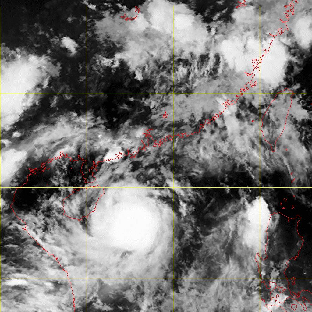
6 Case 1 T Chanchu (May 06) Satellite / radar imageries At around 15/1730UTC

7 Case 1 T Chanchu (May 06) Estimating cloud top height
8 Case 1 T Chanchu (May 06) Issuing WC SIGMET message* At 15/1745UTC TC position at observation time Valid period start from time when TC enters FIR/CTA WCSS20 VHHH VHHK SIGMET 5 VALID / VHHH- VHHK HONG KONG FIR TC CHANCHU OBS AT 1500Z N1548 E11512 CB TOP FL450 WI 240NM OF CENTRE MOV N 8KT NC FCST 0900Z TC CENTRE N1812 E11448= Can be estimated from satellite imagery Available from TCAC; can be derived from FCST MAX WIND * Fictitious message for demonstration purpose Forecast position normally at the end of the valid period
9 Other information supporting the issuance of WC SIGMET Forecast from MWO (e.g. HKO) and other centres Cloud top height estimation Intensity estimation
10 Case 1 T Chanchu (May 06) Forecast by MWO (e.g. HKO)* WTSS20 VHHH TROPICAL CYCLONE WARNING AT UTC, TYPHOON CHANCHU (0601) WITH CENTRAL PRESSURE 945 HECTOPASCALS WAS CENTRED WITHIN 30 NAUTICAL MILES OF ONE FIVE POINT EIGHT DEGREES NORTH (15.8 N) ONE ONE FIVE POINT TWO DEGREES EAST (115.2 E) AND IS FORECAST TO MOVE NORTH AT ABOUT 8 KNOTS FOR THE NEXT 24 HOURS. MAXIMUM WINDS NEAR THE CENTRE ARE ESTIMATED TO BE 90 KNOTS. RADIUS OF OVER 33 KNOT WINDS 240 NAUTICAL MILES. RADIUS OF OVER 47 KNOT WINDS 100 NAUTICAL MILES. RADIUS OF OVER 63 KNOT WINDS 50 NAUTICAL MILES. RADIUS OF OVER 2 METRE WAVES 330 NAUTICAL MILES. FORECAST POSITION AND INTENSITY AT UTC ONE NINE POINT ZERO DEGREES NORTH (19.0 N) ONE ONE FOUR POINT SIX DEGREES EAST (114.6 E) MAXIMUM WINDS 95 KNOTS. FORECAST POSITION AND INTENSITY AT UTC TWO THREE POINT ZERO DEGREES NORTH (23.0 N) ONE ONE FIVE POINT FIVE DEGREES EAST (115.5 E) MAXIMUM WINDS 85 KNOTS. FORECAST POSITION AND INTENSITY AT UTC TWO SEVEN POINT ZERO DEGREES NORTH (27.0 N) ONE ONE SEVEN POINT ZERO DEGREES EAST (117.0 E) MAXIMUM WINDS 60 KNOTS. Annex 3 recommends SIGMET messages issued in accordance with 7.1.4, concerning volcanic ash cloud and tropical cyclones should be based on advisory information provided by VAACs and TCACs respectively, designated by regional air navigation agreement (7.1.5). * Fictitious message for demonstration purpose
11 Case 1 T Chanchu (May 06) Estimating cloud top height MTSAT/Fengyun cloud top temperature check cloud top pressure from tephigram nearby FL MODIS multi-channel retrieval MODIS MOD04 output
")

12 Estimating intensity Case 1 T Chanchu (May 06) 15/1738UTC 17/0138UTC D vorak analysis Doppler velocity
13 Case 1 T Chanchu (May 06) Estimating intensity (con t)
 Satellite")

14 Case 1 T Chanchu (May 06) Satellite / radar imageries At around 17/2030UTC
15 Case 2 TS Jelawat (Jun 06) Canceling WC SIGMET message* WCSS20 VHHH VHHK SIGMET 10 VALID / VHHH- VHHK HONG KONG FIR TC CHANCHU OBS AT 1800Z N2324 E11700 CB TOP FL450 WI 240NM OF CENTRE MOV NE 16KT WKN FCST 0000Z TC CENTRE N2454 E11812= WCSS20 VHHH VHHK SIGMET 11 VALID / VHHH- VHHK HONG KONG FIR CNL SIGMET /180000= Valid period from issue time of cancel message to end of valid time of message to be cancelled * Fictitious message for demonstration purpose Sequence number and valid period of message to be cancelled


16 Case 2 TS Jelawat (Jun 06)

17 Before there is a need to issue WC SIGMET* At 26/1142UTC 26/1138UTC Case 2 TS Jelawat (Jun 06) WCSS20 VHHH VHHK SIGMET 1 VALID / VHHH- VHHK HONG KONG FIR EMBD TS FCST S OF N1830 TOP FL400 MOV NW 10KT NC= * Fictitious message for demonstration purpose
18 Forecast by TCAC Tokyo* At 27/1249UTC Case 2 TS Jelawat (Jun 06) ZCZC SMB GG VHHHYMYX WSSSYMYX FKPQ30 RJTD TC ADVISORY DTG: /1200Z TCAC: TOKYO TC: JELAWAT NR: 6 PSN: N1755 E11320 MOV: WNW 10KT C: 998HPA MAX WIND: 35KT FCST PSN +6HR: 27/1800Z N1830 E11273 FCST MAX WIND +12HR: 40KT FCST PSN +12HR: 28/0000Z N1905 E11225 FCST MAX WIND +12HR: 40KT FCST PSN +18HR: 28/0600Z N1968 E11190 FCST MAX WIND +18HR: 40KT FCST PSN +24HR: 28/1200Z N2030 E11155 FCST MAX WIND +24HR: 45KT NXT MSG: /1800Z = NNNN Intensifies into a tropical storm within FIR at about 12UTC * Fictitious message for demonstration purpose

19 Case 2 TS Jelawat (Jun 06) Satellite / radar imageries At around 27/1330UTC 27/1338UTC
20 Case 2 TS Jelawat (Jun 06) Forecast by MWO (ie. HKO)* WTSS20 VHHH TROPICAL CYCLONE WARNING TROPICAL DEPRESSION JELAWAT (0602) HAS INTENSIFIED INTO A TROPICAL STORM WITH CENTRAL PRESSURE 996 HECTOPASCALS. AT UTC, IT WAS CENTRED WITHIN 90 NAUTICAL MILES OF ONE EIGHT POINT ZERO DEGREES NORTH (18.0 N) ONE ONE THREE POINT EIGHT DEGREES EAST (113.8 E) AND IS FORECAST TO MOVE NORTHWEST AT ABOUT 8 KNOTS FOR THE NEXT 24 HOURS. MAXIMUM WINDS NEAR THE CENTRE ARE ESTIMATED TO BE 35 KNOTS. RADIUS OF OVER 33 KNOT WINDS 30 NAUTICAL MILES. RADIUS OF OVER 2 METRE WAVES 150 NAUTICAL MILES OVER EASTERN SEMICIRCLE, 120 NAUTICAL MILES ELSEWHERE. FORECAST POSITION AND INTENSITY AT UTC TWO ZERO POINT SIX DEGREES NORTH (20.6 N) ONE ONE ONE POINT EIGHT DEGREES EAST (111.8 E) MAXIMUM WINDS 40 KNOTS. FORECAST POSITION AND INTENSITY AT UTC TWO TWO POINT EIGHT DEGREES NORTH (22.8 N) ONE ONE ZERO POINT SIX DEGREES EAST (110.6 E) MAXIMUM WINDS 30 KNOTS. FORECAST POSITION AND INTENSITY AT UTC DISSIPATED OVER LAND. Annex 3 recommends SIGMET messages issued in accordance with 7.1.4, concerning volcanic ash cloud and tropical cyclones should be based on advisory information provided by VAACs and TCACs respectively, designated by regional air navigation agreement (7.1.5). * Fictitious message for demonstration purpose


21 Case 2 TS Jelawat (Jun 06) Estimating cloud top height

")
22 Estimating intensity Case 2 TS Jelawat (Jun 06) 27/1338UTC
23 Case 2 TS Jelawat (Jun 06) Issuing WC SIGMET message* TC position at observation time Valid period start from time when TC strengthened into a tropical storm in FIR/CTA VHHK SIGMET 5 VALID / VHHH- VHHK HONG KONG FIR TC JELAWAT OBS AT 1200Z N1800 E11348 CB TOP FL400 WI 200NM OF CENTRE MOV NW 8KT NC FCST 1800Z TC CENTRE N1848 E11318= Can be estimated from satellite imagery Available from TCAC; can be derived from FCST MAX WIND * Fictitious message for demonstration purpose Forecast position normally at the end of the valid period

24 Case 2 TS Jelawat (Jun 06) Satellite / radar imageries At around 28/0530UTC
25 Case 2 TS Jelawat (Jun 06) Canceling WC SIGMET message* VHHK SIGMET 1 VALID / VHHH- VHHK HONG KONG FIR TC JELAWAT OBS AT 0000Z N1900 E11142 CB TOP FL400 WI 200NM OF CENTRE MOV NW 8KT NC FCST 0600Z TC CENTRE N1942 E11118= No cancellation message was issued since Jelawat moved out of Hong Kong FIR just before expiration of the message * Fictitious message for demonstration purpose
26 Do s Follow template strictly The message should be short and clear without additional descriptive materials other than those in Annex 3 Compilation/filing time should be equal/close to start of valid period For an expected event, event commencement time is also the start of valid period Lead time should be up to 12 hours Issue graphical SIGMET in BUFR code form for MWOs in a position to do so
27 Thank you
WV SIGMET Summary. Office of Aviation Weather Forecasting Japan Meteorological Agency
 WV SIGMET Summary Office of Aviation Weather Forecasting Japan Meteorological Agency Example of WV SIGMET ICAO location indicator of FIR Message indicator Daily sequence number Validity indicator Validity
International Civil Aviation Organization NINETEENTH MEETING OF THE METEOROLOGY SUB-GROUP (MET SG/19) OF APANPIRG. Bangkok, Thailand, 3 6 August 2015
 OF APANPIRG. Bangkok, Thailand, 3 6 August 2015") MET SG/19 - WP/19 International Civil Aviation Organization NINETEENTH MEETING OF THE METEOROLOGY SUB-GROUP (MET SG/19) OF APANPIRG Bangkok, Thailand, 3 6 August 2015 : Regional Guidance Material SIGMET
MET SG/19 - WP/19 International Civil Aviation Organization NINETEENTH MEETING OF THE METEOROLOGY SUB-GROUP (MET SG/19) OF APANPIRG Bangkok, Thailand, 3 6 August 2015 : Regional Guidance Material SIGMET
Issue of SIGMET/AIRMET warning part II
 Issue of SIGMET/AIRMET warning part II 1 SIGMET SIGMET is warning information and hence it is of highest priority amongst other types of meteorological information provided to the aviation users. This
How to issue SIGMET. SIGMET Seminar for Asia/Pacific Region Bangkok, Thailand, July 2007
 How to issue SIGMET SIGMET Seminar for Asia/Pacific Region Bangkok, Thailand, 11-13 July 2007 Shikembaru, Toru 志堅原透 Japan Meteorological Agency (JMA) 日本気象庁 Japan Meteorological Agency 1 Contents of lecture
Introduction to SIGMET. 28 June 2016 Japan Meteorological Agency
 Introduction to SIGMET 28 June 2016 Japan Meteorological Agency SIGMET Definition SIGMET information Information issued by a meteorological watch office concerning the occurrence or expected occurrence
NOAA s National Weather Service VAAC Anchorage. Don Moore
 NOAA s National Weather Service VAAC Anchorage Don Moore VAAC Best Practices Workshop May 2015 Volcanic Eruptions Volcanic Eruptions Volcanic Eruptions VAAC Anchorage and Alaska Aviation Weather Unit (AAWU)
REPORT ON COMPARISON BETWEEN THE NUMBER OF COORDINATED SIGMET AND TOTAL SIGMET ISSUANCE FROM PILOT PROJECT TIME FRAME(MONDAY TO FRIDAY FROM 00UTC
 Wrap up Meeting Of The Pilot Project on SIGMET Coordination, Singapore 27 29 March 2017 REPORT ON COMPARISON BETWEEN THE NUMBER OF COORDINATED SIGMET AND TOTAL SIGMET ISSUANCE FROM PILOT PROJECT TIME FRAME(MONDAY
MET PANEL (METP) MET OPERATIONS GROUP (MOG) INTERNATIONAL AIRWAYS VOLCANO WATCH (IAVW)
 MET OPERATIONS GROUP (MOG) INTERNATIONAL AIRWAYS VOLCANO WATCH (IAVW)") METP MOG/8 -SN/9 18/10/18 MET PANEL (METP) MET OPERATIONS GROUP (MOG) INTERNATIONAL AIRWAYS VOLCANO WATCH (IAVW) EIGHTH MEETING Wellington, New Zealand, 12 to 14 November 2018 Agenda Item 4: MOG (IAVW)
METP MOG/8 -SN/9 18/10/18 MET PANEL (METP) MET OPERATIONS GROUP (MOG) INTERNATIONAL AIRWAYS VOLCANO WATCH (IAVW) EIGHTH MEETING Wellington, New Zealand, 12 to 14 November 2018 Agenda Item 4: MOG (IAVW)
DR RAJENDRA KUMAR JENAMANI
 TCAC NEW DELHI METHODS AND PROCEDURES USED FOR PREDICTION DR RAJENDRA KUMAR JENAMANI Director In-Charge Meteorological Watch Office (MWO) INDIA METEOROLOGICAL DEPARTMENT New ATS Building (Room No.-211,
AN EMPIRICAL MODEL FOR AERODROME WIND FORECASTING DURING THE PASSAGE OF TROPICAL CYCLONES
 P1.1 AN EMPIRICAL MODEL FOR AERODROME WIND FORECASTING DURING THE PASSAGE OF TROPICAL CYCLONES T. C. Cheung The Chinese University of Hong Kong Hong Kong China P. Cheung C. C. Lam * Hong Kong Observatory
Dispersion modelling and warnings for volcanic ash in the Australian Region
 Dispersion modelling and warnings for volcanic ash in the Australian Region R Potts, R Dare, E Jansons, C Lucas, A Tupper, M Zidikheri The Centre for Australian Weather and Climate Research A partnership
How Tokyo VAAC s forecasters uses RGB products
 How Tokyo VAAC s forecasters uses RGB products RGB Experts and Developers Workshop 2017 @ Tokyo, Japan 8 November 2017 Tokyo Volcanic Advisory Center Hiroaki TSUCHIYAMA Areas of Responsibility of the Nine
Issue of SIGMET/AIRMET warning
 Issue of SIGMET/AIRMET warning 1 Presentation Objectives After this presentation session you will be able to: Warn for Hazardous weather phenomena using the correct ICAO coding with regards to SIGMET/AIRMET
How the Bureau of Meteorology contributes to the integrated risk picture. Presented by Michael Berechree
 How the Bureau of Meteorology contributes to the integrated risk picture Presented by Michael Berechree Mission Meteorological Service The mission of the Bureau's Aviation Meteorological Service is to
Table of Contents. Chapter 1 Operations at the RSMC Tokyo - Typhoon Center in 2006
 Annual Report on the Activities of the RSMC Tokyo - Typhoon Center 20 06 TY SAOMAI (0608) 00 UTC, 10 Aug. 2006 Japan Meteorological lagency Table of Contents Introduction Page Chapter 1 Operations at the
Information Note on the Webpage for Significant Convection Monitoring and Forecast
 Information Note on the Webpage for Significant Convection Monitoring and Forecast The webpage displays both the real-time products for monitoring of significant convection and forecast products for significant
Several issues on VAAC operation - Tokyo VAAC s approach -
 Several issues on VAAC operation - Tokyo VAAC s approach - SATOSHI HARADA VAAC TOKYO / JMA Several issues on VAAC operation 1. How to deal with information overload? 2. How to use inconsistent plume height
Regional Seminar on Aviation Meteorology Service in Asia Beijing, China (11-15 April 2011)
") Regional Seminar on Aviation Meteorology Service in Asia Beijing, China (11-15 April 2011) Aviation Meteorology Service in Myanmar Mr.Hla Shwe Staff Officer Department of Meteorology and Hydrology Myanmar
Regional Seminar on Aviation Meteorology Service in Asia Beijing, China (11-15 April 2011) Aviation Meteorology Service in Myanmar Mr.Hla Shwe Staff Officer Department of Meteorology and Hydrology Myanmar
ACTIVITIES OF THE RSMC TOKYO - TYPHOON CENTER IN 2010
 ECONOMIC AND SOCIAL COMMISSION FOR ASIA AND THE PACIFIC AND WORLD METEOROLOGICAL ORGANIZATION WRD/TC.43/5.1 Add. 2 18 January 2011 Typhoon Committee Forty Third Session 17 to 22 January 2011 Jeju, Republic
Annual Report on the Activities of the RSMC Tokyo - Typhoon Center 2012
 Annual Report on the Activities of the RSMC Tokyo - Typhoon Center 2012 TY Sanba 00 UTC, 14 September 2012 Japan Meteorological Agency Annual Report on the Activities of the RSMC Tokyo - Typhoon Center
TROPICAL CYCLONE TC 03A FOR THE PERIOD 3 RD JUNE TO 10 TH JUNE, 1998
 TROPICAL CYCLONE TC 03A FOR THE PERIOD 3 RD JUNE TO 10 TH JUNE, 1998 Hazrat Mir, Abdul Rashid, Waqarul Wheed Khan. Introduction: This report gives the review of cyclonic storm formed over the East Arabian
BMKG SIGMET COORDINATION PROJECT. Wrap up Meeting Of The Pilot Project on SIGMET Coordination, Singapore March 2017
 SIGMET COORDINATION PROJECT Wrap up Meeting Of The Pilot Project on SIGMET Coordination, Singapore 27 29 March 2017 1. Staff awareness and training a. National MWO Coordination Meeting, (Ujung Pandang,
Have a better understanding of the Tropical Cyclone Products generated at ECMWF
 Objectives Have a better understanding of the Tropical Cyclone Products generated at ECMWF Learn about the recent developments in the forecast system and its impact on the Tropical Cyclone forecast Learn
Fernando Prates. Evaluation Section. Slide 1
 Fernando Prates Evaluation Section Slide 1 Objectives Ø Have a better understanding of the Tropical Cyclone Products generated at ECMWF Ø Learn the recent developments in the forecast system and its impact
Annual Report on the Activities of the RSMC Tokyo - Typhoon Center 2008
 Annual Report on the Activities of the RSMC Tokyo - Typhoon Center 2008 TY JANGMI 06 UTC, 27 Sep 2008 Japan Meteorological Agency Table of Contents Introduction Page Chapter 1 Operations at the RSMC Tokyo
Your Source for Global Aviation Forecasts
 Your Source for Global Aviation Forecasts (831) 238-5054 100 Sky Park Drive Monterey, CA 93940 Weather4Cast.com Live Weather Data Feeds Weather4Cast.com provides Live Aviation Weather Data Feeds formatted
TYPHOON COMMITTEE OPERATIONAL MANUAL METEOROLOGICAL COMPONENT Edition
 W O R L D M E T E O R O L O G I C A L O R G A N I Z A T I O N T E C H N I C A L D O C U M E N T WMO/TD-No. 196 TROPICAL CYCLONE PROGRAMME Report No. TCP-23 TYPHOON COMMITTEE OPERATIONAL MANUAL METEOROLOGICAL
FINAL REPORT ON THE PILOT PROJECT ON SIGMET COORDINATION IN SOUTHEAST ASIA
 FINAL REPORT ON THE PILOT PROJECT ON SIGMET COORDINATION IN SOUTHEAST ASIA 4 OCTOBER 2016 3 MARCH 2017 Prepared by Pilot Project Coordinator, Meteorological Service Singapore With inputs from BMKG and
Australian Aviation Weather Services for Air Traffic Management
 Australian Aviation Weather Services for Air Traffic Management Presentation to the ICAO ASIA/PAC Meteorology/Air Traffic Management Seminar 26 28 November 2013, Bangkok, Thailand Craig Deitch ATM Operational
TYPHOON COMMITTEE OPERATIONAL MANUAL METEOROLOGICAL COMPONENT Edition
 WORLD METEOROLOGICAL ORGANIZATION TECHNICAL DOCUMENT WMO/TD-No. 196 TROPICAL CYCLONE PROGRAMME Report No. TCP-23 TYPHOON COMMITTEE OPERATIONAL MANUAL METEOROLOGICAL COMPONENT SECRETARIAT OF THE WORLD METEOROLOGICAL
Application of NWP products and meteorological information processing system in Hong Kong
 Application of NWP products and meteorological information processing system in Hong Kong Y.S. Li Scientific Officer Hong Kong Observatory (ysli@hko.gov.hk) 7 million people Hong Kong ~1,100 km sq. Regional
Remote Sensing of Windshear under Tropical Cyclone Conditions in Hong Kong
 Remote Sensing of Windshear under Tropical Cyclone Conditions in Hong Kong Dr H K Lam Director of the Hong Kong Observatory Permanent Representative of Hong Kong, China with WMO Vice-President of WMO Regional
AIR NAVIGATION COMMISSION
 International Civil Aviation Organization AN-WP/9187 3/1/18 WORKING PAPER AIR NAVIGATION COMMISSION APPROVAL OF DRAFT REPORT TO COUNCIL ON AMENDMENT 78 TO ANNEX 3 (Item No. 20707) (Presented by the Direct
JTWC's Use of TRMM in Typhoon Forecast Operations
 Use of TRMM in Typhoon Forecast Operations JTWC's Use of TRMM in Typhoon Forecast Operations Slide 1/24 Use of TRMM in Typhoon Forecast Operations Slide 2/24 Opening Comments The current microwave satellite
Annual Report on the Activities of the RSMC Tokyo - Typhoon Center 2014
 Annual Report on the Activities of the RSMC Tokyo - Typhoon Center 2014 TY Vongfong 23 UTC, 7 October 2014 Japan Meteorological Agency Annual Report on the Activities of the RSMC Tokyo - Typhoon Center
Annual Report on Activities of the RSMC Tokyo Typhoon Center 2001
 Annual Report on Activities of the RSMC Tokyo Typhoon Center 2001 Japan Meteorological Agency Annual Report 2001 Table of Contents Introduction Page Chapter 1 Operations at the RSMC Tokyo Typhoon Center
2006 Annual Tropical Cyclone Report U.S. Naval Maritime Forecast Center/ Joint Typhoon Warning Center Pearl Harbor, Hawaii
 Annual Tropical Cyclone Report U.S. Naval Maritime Forecast Center/ Joint Typhoon Warning Center Pearl Harbor, Hawaii Composite MODIS true color image from the Aqua satellite of Super Typhoon C (Ioke)
FREEZING CONTAMINATION : AIRCRAFT ICING
 FREEZING CONTAMINATION : AIRCRAFT ICING PUTTING THE FORECASTS IN PLACE A transmission chain of adapted information SIGMET, AIRMET, GAMET, SIGWX charts PIREPS Awareness of the icing phenomena A few points
Regional Hazardous Weather Advisory Centres (RHWACs)
") Regional Hazardous Weather Advisory Centres (RHWACs) The following outlines the criteria for the selection of RHWACs based on operational and functional requirements 1. Basic Principles The RHWAC must:
Regional Hazardous Weather Advisory Centres (RHWACs) The following outlines the criteria for the selection of RHWACs based on operational and functional requirements 1. Basic Principles The RHWAC must:
RAN CAR/SAM/3 Recommendation 13/14 Guide for the preparation and dissemination of SIGMET messages, October 1999, Buenos Aires, Argentina
 Ref.: LT 13/4.1.1 SA402 20 June 2006 To: Mr. Jean-Marc Sansovini, Directeur Regional de l Aviation Civile aux Antilles et en Guyane cc: Mrs. Isabelle Monnier, Chef du Service de la Navigation Aérienne
Flight north of Iceland...near Eyjafjallajokull
 Flight north of Iceland...near Eyjafjallajokull Presented by Cpt. Heinz Frühwirth, IFALPA Prepared by Cpt. Klaus Sievers, German ALPA 27 June 2011 This presentation concerns a flight from Europe to the
Hurricane Structure: Theory and Diagnosis
 Hurricane Structure: Theory and Diagnosis 7 March, 2016 World Meteorological Organization Workshop Chris Landsea Chris.Landsea@noaa.gov National Hurricane Center, Miami Outline Structure of Hurricanes
Volcanic Ash Operator Experience
 Volcanic Ash Operator Experience Eyjafjallajokull Eme Tillema Dep VP ATM KLM Flight Operations Cologne 9 Sept 2010 1 Facts Eyjafjallajokull Eruption on the 14 th of April 2010 European Airspace Closure
Current Details from the Joint Typhoon Warning Center
 Current Details from the Joint Warning Center COORDINATES: 19.6 north, 125.5 east (previous location: 17.9 north, 130.3 east) LOCATION: 737 kilometers (458 miles) southeast of Taipei, Taiwan MOVEMENT:
FLIGHT DOCUMENTATION Z VRB01KT CAVOK 17/15 Q1014 NOSIG=
 FLIGHT DOCUMENTATION 15-10-2018 19:10 KNMI F L I G H T D O C U M E N T A T I O N F TNCB KRALENDIJK/FLAMINGO --> EHAM AMSTERDAM/SCHIPHOL M E T A R 151855 151900 151905 151900 151900 RRL 151755 EHAM TNCB
Tropical Storm Colin Briefing Last Briefing on this System
 Tropical Storm Colin Briefing Last Briefing on this System NWS WFO Jacksonville, Florida Tuesday, June 07, 2016 6:00 a.m. EDT Tropical Storm Colin s Impacts SE Georgia & North Florida Local Watches & Warnings:
Storm Summary for Hurricane Jose
 Storm Summary for Hurricane Jose Tuesday, September 19, 2017 at 11 AM EDT (Output from Hurrevac, based on National Hurricane Center Forecast Advisory #57) Jose is currently a Category 1 hurricane on the
National Report on Weather Forecasting Service
 MINISTRY OF WATER RESOURCES AND METEOROLOGY DEPARTMENT OF METEOROLOGY, CAMBODIA National Report on Weather Forecasting Service Tokyo, 11-15 March 2014 Department of Meteorology, Cambodia Presentation Outline
Wrap-Up Meeting of the pilot project on SIGMET Coordination in South East Asia (MetMalaysia, MSS & BMKG) Singapore
 Singapore") Wrap-Up Meeting of the pilot project on SIGMET Coordination in South East Asia (MetMalaysia, MSS & BMKG) Singapore 27-29 March 2017 Agenda Item 4 (NMHS experiences and recommendations) Hamray Bin Muhammad
Wrap-Up Meeting of the pilot project on SIGMET Coordination in South East Asia (MetMalaysia, MSS & BMKG) Singapore 27-29 March 2017 Agenda Item 4 (NMHS experiences and recommendations) Hamray Bin Muhammad
Meteorological Priorities in Support of a Volcanic Ash Strategy ( )
") Meteorological Priorities in Support of a Volcanic Ash Strategy (2010-11) Ian Lisk, Met Office Volcanic Ash Coordination Programme Manager; EUMETNET VA coordinator; WMO CAeM vice-president. Introduction
Meteorological Priorities in Support of a Volcanic Ash Strategy (2010-11) Ian Lisk, Met Office Volcanic Ash Coordination Programme Manager; EUMETNET VA coordinator; WMO CAeM vice-president. Introduction
Reprint 850. Within the Eye of Typhoon Nuri in Hong Kong in C.P. Wong & P.W. Chan
 Reprint 850 Remote Sensing Observations of the Subsidence Zone Within the Eye of Typhoon Nuri in Hong Kong in 2008 C.P. Wong & P.W. Chan 8 th International Symposium on Tropospheric Profiling: Integration
Washington Volcanic Ash Advisory Center
 How a Volcanic Ash Advisory and a Dispersion Forecast is Prepared: Jamie Kibler Washington VAAC Operations Manger/Meteorologist October 25, 2011 ICAO Seminar on Volcanic Ash Products and Communications
A Tropical Cyclone with a Very Large Eye
 JANUARY 1999 PICTURES OF THE MONTH 137 A Tropical Cyclone with a Very Large Eye MARK A. LANDER University of Guam, Mangilao, Guam 9 September 1997 and 2 March 1998 1. Introduction The well-defined eye
Wind data collected by a fixed-wing aircraft in the vicinity of a typhoon over the south China coastal waters
 Wind data collected by a fixed-wing aircraft in the vicinity of a typhoon over the south China coastal waters P.W. Chan * and K.K. Hon Hong Kong Observatory, Hong Kong, China Abstract: The fixed-wing aircraft
International Civil Aviation Organization FOURTH MEETING OF ASIA/PACIFIC METEOROLOGICAL REQUIREMENTS TASK FORCE (MET/R TF/4)
") MET/R TF/4 IP/01 International Civil Aviation Organization FOURTH MEETING OF ASIA/PACIFIC METEOROLOGICAL REQUIREMENTS TASK FORCE (MET/R TF/4) Tokyo, Japan, 2 3 July 2015 : MET required to support end user
MET/R TF/4 IP/01 International Civil Aviation Organization FOURTH MEETING OF ASIA/PACIFIC METEOROLOGICAL REQUIREMENTS TASK FORCE (MET/R TF/4) Tokyo, Japan, 2 3 July 2015 : MET required to support end user
AVIATION APPLICATIONS OF A NEW GENERATION OF MESOSCALE NUMERICAL WEATHER PREDICTION SYSTEM OF THE HONG KONG OBSERVATORY
 P452 AVIATION APPLICATIONS OF A NEW GENERATION OF MESOSCALE NUMERICAL WEATHER PREDICTION SYSTEM OF THE HONG KONG OBSERVATORY Wai-Kin WONG *1, P.W. Chan 1 and Ivan C.K. Ng 2 1 Hong Kong Observatory, Hong
1 of 5 20/01/2015 2:05 PM
 1 of 5 20/01/2015 2:05 PM AWWS News : There are 2 active notices. Last update: 2014/09/17 Request Generated 01/20/2015 at 22:01:08 UTC. Weather information available at that time is displayed. Go to a
55 th CONFERENCE OF DIRECTORS GENERAL OF CIVIL AVIATION ASIA AND PACIFIC REGION
 DGCA 55/IP/4/8 55 th CONFERENCE OF DIRECTORS GENERAL OF CIVIL AVIATION ASIA AND PACIFIC REGION Denarau Island, Nadi, Fiji 22 26 October 2018 AGENDA ITEM 4: AIR NAVIGATION OPERATION OF ASIAN AVIATION METEOROLOGICAL
METEOROLOGICAL WARNINGS STUDY GROUP (METWSG) FOURTH MEETING. Montréal, 15 to 18 May 2012 REVIEW AND EVALUATION OF SIGMET ADVISORY TRIAL IN ASIA
 FOURTH MEETING. Montréal, 15 to 18 May 2012 REVIEW AND EVALUATION OF SIGMET ADVISORY TRIAL IN ASIA") 23/4/12 METEOROLOGICAL WARNINGS STUDY GROUP (METWSG) FOURTH MEETING Montréal, 15 to 18 May 2012 Agenda Item 5: SIGMET/AIRMET 5.1: SIGMET implementation REVIEW AND EVALUATION OF SIGMET ADVISORY TRIAL IN
23/4/12 METEOROLOGICAL WARNINGS STUDY GROUP (METWSG) FOURTH MEETING Montréal, 15 to 18 May 2012 Agenda Item 5: SIGMET/AIRMET 5.1: SIGMET implementation REVIEW AND EVALUATION OF SIGMET ADVISORY TRIAL IN
Regional Hazardous Weather Advisory Centres (RHWACs)
") Regional Hazardous Weather Advisory Centres (RHWACs) The following outlines the criteria for the selection of RHWACs based on operational and functional requirements 1. Basic Principles The RHWAC must:
Regional Hazardous Weather Advisory Centres (RHWACs) The following outlines the criteria for the selection of RHWACs based on operational and functional requirements 1. Basic Principles The RHWAC must:
The Nowcasting Demonstration Project for London 2012
 The Nowcasting Demonstration Project for London 2012 Susan Ballard, Zhihong Li, David Simonin, Jean-Francois Caron, Brian Golding, Met Office, UK Introduction The success of convective-scale NWP is largely
Annual Report on the Activities of the RSMC Tokyo - Typhoon Center 2016
 Annual Report on the Activities of the RSMC Tokyo - Typhoon Center 2016 TY Meranti 09 UTC,13 September 2016 Japan Meteorological Agency Annual Report on the Activities of the RSMC Tokyo - Typhoon Center
NHC Ocean Vector Winds Update
 NHC Ocean Vector Winds Update Michael J. Brennan NOAA/NWS/NCEP National Hurricane Center International Ocean Vector Winds Science Team Meeting Portland, Oregon, 20 May 2015 Current Status NHC is currently
Wind Speed Probability Products
 Wind Speed Probability Products Daniel Brown National Hurricane Center 2018 WMO Course 6 March 2018 Wind Speed Probabilities A Tool to Deal with Uncertainty Hurricane Irene Advisory Number 12 Issued 5:00
Explosive volcanic eruptions in the North Pacific: Interactions between the Alaska Volcano Observatory and Volcanic Ash Advisory Centers
 Explosive volcanic eruptions in the North Pacific: Interactions between the Alaska Volcano Observatory and Volcanic Ash Advisory Centers David Schneider U.S. Geological Survey Alaska Volcano Observatory
Wind Speed Probability Products. Daniel Brown and Michael Brennan National Hurricane Center
 Wind Speed Probability Products Daniel Brown and Michael Brennan National Hurricane Center 2017 WMO Course 7 March 2017 Wind Speed Probabilities A Tool to Deal with Uncertainty Hurricane Irene Advisory
Inter-comparison MTSAT-2 & Himawari-8
 Inter-comparison MTSAT-2 & Himawari-8 WMO Volcanic Ash Advisory Centre Best Practice Workshop 2017 Tokyo Volcanic Ash Advisory Centre Japan Meteorological Agency Outline Introduction Method Case study
Briefing on the WMO Support to Viet Nam to cope with Typhoon Haiyan
 WMO Briefing on the WMO Support to Viet Nam to cope with Typhoon Haiyan A Case of WMO Emergency Response Typhoon Haiyan trajectory Background Typhoon Haiyan remained strong after devastating the Philippines
<<INSERT REGION>> REGIONAL SIGMET GUIDE INTERNATIONAL CIVIL AVIATION ORGANIZATION <<INSERT EDITION NO.>> EDITION <<INSERT MONTH AND YEAR>>
 INTERNATIONAL CIVIL AVIATION ORGANIZATION REGIONAL SIGMET GUIDE EDITION Note: This template includes changes agreed f Amendment 78 to
Upgrade of JMA s Typhoon Ensemble Prediction System
 Upgrade of JMA s Typhoon Ensemble Prediction System Masayuki Kyouda Numerical Prediction Division, Japan Meteorological Agency and Masakazu Higaki Office of Marine Prediction, Japan Meteorological Agency
INTERNATIONAL CIVIL AVIATION ORGANIZATION
 INTERNATIONAL CIVIL AVIATION ORGANIZATION WESTERN AND CENTRAL AFRICA OFFICE (WACAF) ICAO Regional Seminar on ATS/MET/Pilots Coordination (Yaoundé, Cameroon, 23 25 August 2010) Agenda item 7 : Volcanic
W.H. Leung, W.M. Ma and H.K. Yeung Hong Kong Observatory, Hong Kong, China
 322 THE APPLICATION OF LIGHTNING DENSITY MAP IN THE ANALYSIS OF A SEVERE RAINSTORM CASE IN HONG KONG W.H. Leung, W.M. Ma and H.K. Yeung Hong Kong Observatory, Hong Kong, China 1. INTRODUCTION On 22 July
the issue of for Aviation
 2/3/12 INTERNATIONAL VOLCANIC ASH TASK FORCE (IVATF) SECOND MEETING Montréal, 11 to 15 July 2011 List of Recommendations The second meeting of the International Volcanic Ash Task Force (IVATF/2), held
ERTH 365 Homework #2: Hurricane Harvey. 100 points
 ERTH 365 Homework #2: Hurricane Harvey 100 points Due by 6pm, Tuesday 30 October 2018, ELECTRONIC SUBMISSON BY EMAIL ONLY BY 6PM (send to klevey@sfsu.edu) (acceptable formats: MS Word, Google Doc, plain
A tail strike event of an aircraft due to terrain-induced wind shear at the Hong Kong International Airport
 METEOROLOGICAL APPLICATIONS Meteorol. Appl. 21: 504 511 (2014) Published online 14 March 2012 in Wiley Online Library (wileyonlinelibrary.com) DOI: 10.1002/met.1303 A tail strike event of an aircraft due
2014 海峽兩岸暨香港地區航空氣象技術講座
 2014 海峽兩岸暨香港地區航空氣象技術講座 P W Li Vice chair Hong Kong Meteorological Society Senior Scientific Officer, Hong Kong Observatory pwli@hko.gov.hk www.meteorology.org.hk GUANGZHOU FIR HK FIR TAIPEI FIR About 276,000
Allocation of percentage Marks Practical rd February, st March, th March nd March
 UNIVERSITY OF NAIROBI COLLEGE OF BIOLOGICAL AND PHYSICAL SCIENCES School of Physical Sciences Post Graduate Diploma in Aviation Meteorology Aviation Weather (SMR 525) Practical Manual for Academic Year
Volcanic Ash Monitoring Claus Zehner, ESA
 Volcanic Ash Monitoring Claus Zehner, ESA Slide: 1 Support to Aviation Control Service A global Alert (and Analysis demonstration only) system for volcanic Ash and SO2 emissions using satellite measurements
Operations of VAAC. before/after Eyjafjalla2010. ESA / EUMESAT Workshop on Eyjafjalla eruption and ash monitoring from space.
 Operations of VAAC before/after Eyjafjalla2010 ESA / EUMESAT Workshop on Eyjafjalla eruption and ash monitoring from space Philippe Husson IAVW : 9 V A A C T.J Casadevall,., T. B Thompson,., and T. Fox
Standardizing hurricane size descriptors for broadcast to the public
 Standardizing hurricane size descriptors for broadcast to the public Lori Drake, Hurricane Roadmap Project AMS 40th Conference on Broadcast Meteorology August 22-24, 2012, Boston, MA, Operational Forecasting
JMA/WMO WORKSHOP ON EFFECTIVE TROPICAL CYCLONE WARNING IN SOUTHEAST ASIA
 JMA/WMO WORKSHOP ON EFFECTIVE TROPICAL CYCLONE WARNING IN SOUTHEAST ASIA TROPICAL CYCLONE MONITORING IN LAO PDR TOKYO, JAPAN 11 14 March 2014 Ministry of Natural Resource and Environment (MONRE) Department
Outline of 4 Lectures
 Outline of 4 Lectures 1. Sept. 17, 2008: TC best track definition and datasets, global distribution of TCs; Review of history of meteorological satellites, introducing different orbits, scanning patterns,
Comparative Study of Dvorak Analysis in the western North Pacific. Naohisa Koide and Shuji Nishimura Forecast Division, Japan Meteorological Agency
 Comparative Study of Dvorak Analysis in the western North Pacific Naohisa Koide and Shuji Nishimura Forecast Division, Japan Meteorological Agency 1. Introduction The United Nations Economic and Social
Reduction of the Radius of Probability Circle. in Typhoon Track Forecast
 Reduction of the Radius of Probability Circle in Typhoon Track Forecast Nobutaka MANNOJI National Typhoon Center, Japan Meteorological Agency Abstract RSMC Tokyo - Typhoon Center of the Japan Meteorological
DISCERNIBLE ASH AND VAA/VAG CONSISTENCY
 WMO VOLCANIC ASH ADVISORY CENTRE BEST PRACTICE WORKSHOP 2017 DISCERNIBLE ASH AND VAA/VAG CONSISTENCY VAAC DARWIN & VAAC TOKYO Presented By: Dr Adele Crozier (VAAC Darwin Manager) VAAC Darwin Discernible
GRAPHICAL NZ SIGWX Graphical New Zealand Significant Weather Chart
 GRAPHICAL NZ SIGWX Graphical New Zealand Significant Weather Chart USER GUIDE GRAPHICAL NZ SIGWX (Graphical New Zealand Significant Weather Chart) 1. Introduction 1.1 The GNZSIGWX Chart provides forecast
Enhancing The Delivery Of Weather & Climate Information To End-Users. by Meteorological Services Division, NEA, Singapore
 Enhancing The Delivery Of Weather & Climate Information To End-Users by Meteorological Services Division, NEA, Singapore WMO RA V Seminar on Enhancing Service Delivery Kuala Lumpur, Malaysia, 2-6 April
2006 ATLANTIC HURRICANE SUMMARY. Weather Research Center Houston, Texas
 2006 ATLANTIC HURRICANE SUMMARY Weather Research Center Houston, Texas Weather Research Center 5104 Caroline Houston, Texas 77004 Phone: 713-529-3076 Fax: 713-528-3538 E-mail: wrc@wxresearch.org 2006 Atlantic
Weathernews Looks Back at 2015: A Year of Storms. Powerful Typhoons Occurred with Changing Patterns in El Niño Years
 NEWS RELEASE January 27th, 2016 Weathernews Looks Back at 2015: A Year of Storms Powerful Typhoons Occurred with Changing Patterns in El Niño Years Weathernews Inc. (Chiba, Japan; Chihito Kusabiraki/CEO)
International Civil Aviation Organization THIRD MEETING OF THE METEOROLOGICAL REQUIREMENTS TASK FORCE (MET/R TF/3)
") MET/R TF/3 IP/02 International Civil Aviation Organization THIRD MEETING OF THE METEOROLOGICAL REQUIREMENTS TASK FORCE (MET/R TF/3) 28 29 November 2013, Bangkok, Thailand Agenda Item 3a: Current and future
MET/R TF/3 IP/02 International Civil Aviation Organization THIRD MEETING OF THE METEOROLOGICAL REQUIREMENTS TASK FORCE (MET/R TF/3) 28 29 November 2013, Bangkok, Thailand Agenda Item 3a: Current and future
Hurricane Structure: Theory and Application. John Cangialosi National Hurricane Center
 Hurricane Structure: Theory and Application John Cangialosi National Hurricane Center World Meteorological Organization Workshop Is this Tropical, Subtropical, or Extratropical? Subtropical Tropical Extratropical
Implementation Guidance of Aeronautical Meteorological Forecaster Competency Standards
 Implementation Guidance of Aeronautical Meteorological Forecaster Competency Standards The following guidance is supplementary to the AMP competency Standards endorsed by Cg-16 in Geneva in May 2011. Implicit
Reprint 797. Development of a Thunderstorm. P.W. Li
 Reprint 797 Development of a Thunderstorm Nowcasting System in Support of Air Traffic Management P.W. Li AMS Aviation, Range, Aerospace Meteorology Special Symposium on Weather-Air Traffic Management Integration,
The Eyjafjallajokull Volcanic Ash Cloud and its Effects on Scottish Air Quality. Update 06 May 2010
 The Eyjafjallajokull Volcanic Ash Cloud and its Effects on Scottish Air Quality. Update 06 May 2010 The volcanic ash cloud from the Eyjafjallakull volcano once again grounded flights from Scottish airports
JMA/WMO WORKSHOP ON EFFECTIVE TROPICAL CYCLONE WARNING IN SOUTHEAST ASIA. Tokyo, Japan March 2014
 Annex IV JMA/WMO WORKSHOP ON EFFECTIVE TROPICAL CYCLONE WARNING IN SOUTHEAST ASIA Tokyo, Japan 11-14 March 2014 Country Report On Tropical Cyclone Monitoring In Cambodia Department of Meteorology 1 1.
The 5th Meeting of the Coordinating Group of the RA II WIGOS Satellite Project
 The 5th Meeting of the Coordinating Group of the RA II WIGOS Satellite Project 21 October, Vladivostok city, Russky Island, Russia Far Eastern Federal University Hong Kong, China Mr. C.K.So, Scientific
1. Introduction. 2. Verification of the 2010 forecasts. Research Brief 2011/ February 2011
 Research Brief 2011/01 Verification of Forecasts of Tropical Cyclone Activity over the Western North Pacific and Number of Tropical Cyclones Making Landfall in South China and the Korea and Japan region
Frank Revitte National Weather Service. Weather Forecast Office New Orleans/Baton Rouge
 Frank Revitte National Weather Service Weather Forecast Office New Orleans/Baton Rouge Above normal activity 17 Total Named Storms 7 Tropical Storms 4 Hurricanes 6 Major Hurricanes Not the most active,
Weather observations by aircraft reconnaissance inside Severe Typhoon Utor
 Weather observations by aircraft reconnaissance inside Severe Typhoon Utor P. W. Chan, W. K. Wong and K. K. Hon Hong Kong Observatory, China Introduction Since 2009, the Hong Kong Observatory (HKO) has
GEN 3.5 METEOROLOGICAL SERVICES
 AIP GEN 3.5-1 GEN 3.5 METEOROLOGICAL SERVICES 1. RESPONSIBLE SERVICE The meteorological services for civil aviation at Jordan are provided by the Jordanian Meteorological Department. Postal Address: Director