Introduction to Conceptual Models
|
|
|
- Lucas Ryan
- 6 years ago
- Views:
Transcription


1 Zentralanstalt für Meteorologie und Geodynamik Introduction to Conceptual Models Veronika Zwatz-Meise


2 IR Satellite Images with Satrep
3 From Cloud systems in satellite images to Conceptual Models If we look into all small details of cloud systems in satellite image there is an unlimited number of configurations If we look from a more distant point of view ignoring smaller details there is a limited number of reappearing configurations These configurations must have a common physical background This is the starting point of Conceptual Models
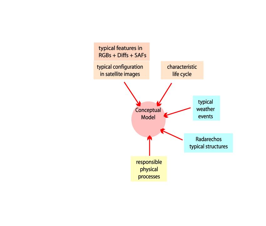
4 Elements of a Conceptual Model Physical processes in the tropopshere lead to a CM comprising: Typical configurations in satellite images Typical weather events Typical features in typical numerical parameter fields Basic Parameters: Pressure, humidity, temperature and so on Derived Parameter: Vorticity, vorticity advection, potential vorticity, temperature advection, convergence and so on Typical features in vertical cross sections
5 Let us construct a Conceptual Model on the breadboard
6
7
8
9
10
11
12
13
14
15
16 From Cloud systems in satellite images to Conceptual Models There are physical processes in the atmosphere which: produce cloudiness form cloudiness Two assumptions for the existence of cloudiness are: enough humidity Upward vertical motion: ω = dp/dt Fundamental mathematical relation for describing vertical motion: Omega equation:
 pressure and vorticityfield are in geostrophic equilibrium The right-hand side of this form of the omega equation consists of three terms: 1.) the vertical change of vorticity advection 2.")
17 Omega equation in a quasi-geostrophic system: 2 important assumptions 1.) in the vertical exists hydrostatic equilibrium 2.) pressure and vorticityfield are in geostrophic equilibrium The right-hand side of this form of the omega equation consists of three terms: 1.) the vertical change of vorticity advection 2.) the Laplacian of temperature advection (the change of the horizontal gradient of temperature advection) 3.) the Laplacian of the diabatic warming (the change of the gradient of diabatic warming) not treated in these lectures
18 Vorticityadvection Temperaturadvection (Diabatic Heating) Not treated In these lectures
19 Temperature and Temperature Advection Laplacian of temperature advection -R/ c p 2 [ - v g p T] Upward motion takes place where the (relative) strongest warm advection exists WA - Warm Advection CA - Cold Advection WA takes place in the areas of fronts, especially in warm fronts
20 Which kind of weather systems do you connect with WA? Cold Fronts Warm fronts Waves Features in the upper level trough Features in the upper level ridge Features connected to the jet stream Others
21
22
23 Different WF cloud configurations Meteorologists identify different features as warm fronts or warmfront like cloud system Are these different cloud configurations also different CMs?
24 Please indicate the WF cloud system With yellow star!

25


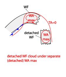
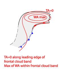
26 WF Band WF Shield Detached WF
27 Vorticity and Vorticity advection as cloud producing and forming parameters Vorticity is a streamfield quality - It describes rotation Vorticity is a parameter which is important for cloud formation Vorticity advection has as connection to upward motion: 1 st term in the omega equation Vorticity Relative Vorticity ζ = rot z v 2 = v/ x - u/ y ζ>0... zyklonal ζ < 0...antizyklonal Vorticity = Curvature vorticity + shear vorticity ζ = VKs - V/ n ζs = - V / n Ks... Curvature of the streamlines V... Velocity Vorticity advection Advection of rel. Vort. VA = - v. ζ positive Vorticity advection PVA: VA > 0 Upward motion negative Vorticityadvektion NVA: VA < 0 : Downward motion
28 PVA - upward motion and necessary pre-condition In the 1st term of the ω equation there is the vertical change of the vorticity advection / p. (- v p. η) A contribution to upward motion is given if: PVA increases with height NVA decreases with height Useful simplification: Wind typically increases with height also vorticity increases typically Instead of the vertical change of vorticity advection only the distinct maxima in upper levels (500 or 300 hpa) are inspected
29 Which kind of weather systems do you connect with PVA Cold Fronts Warm fronts Waves Features in the upper level trough Features in the upper level ridge Features connected to the jet stream Others
30 Typical co-operation of shear and curvature vorticity Typical for troughs, lows Typical for jet streams

31

32
33
34
35 Different Cold air cloud configurations Meteorologists identify different features in the cold air Commas with and without cloud enhancement Enhanced cloudiness without spiral configuration Are these different cloud configurations also different CMs?
36
37
38 comma Enhanced Cumuli
39

40 Potential Vorticity and features in WV images The potential vorticity (PV) is the absolute circulation of an air parcel that is enclosed between two isentropic surfaces PV is the product of absolute vorticity and static stability. Two factors: a dynamical and a thermodynamical element.

41 PV and features in WV images There is a clear relation between PV and water vapour imagery. A low tropopause can be identified in the WV imagery as a dark zone. Circular WV eddies Elongated dark stripes
42 Presentation of PV in connection with satellite images PV has low values in troposphere: values < 1 unit PV has high values in stratosphere: values > 2 units or more Usually the transition between tropopheric and startospheric air is at values beteween 1 and 4 units 1 PV Unit = 10-6 m 2 K(s kg) -1 Two different presentations of PV: As direct values on isentropic surfaces As height of PV = 2 units
43

44
45 Another group of Conceptual Models There is a group of Conceptual Models which belong to both physical states: Upward motion through WA and through PVA Waves at Coldfronts Meteorologists identify different cloud configurations as waves Are they also different Conceptual models?
46 Please indicate the Wave area! With yellow star!
47 Wave Upper Wave Rapid cyclogenesis
48
49
50
51 From where can you learn more? Manuals, Methods and Programs SatManu Manual of Conceptual Models: detailed descriptions, short versians, exercises SatRep Daily operational application of Comceptual models SatRep/online Daily Satrep cases with numerical fields for training Monthly online sessions EUMeTrain Many Cases demonstrating the CM approach
52 Some exercises about: Upper waves Waves Rapid cyclogenesis comma
53 Based only on the satellite features: Where do you see waves? Indicate by star

 a wave (red")
54 Key parameters for waves: surface height: Where do you assume: an upper wave (yellow star) a wave (red star)?

 a wave (red")
55 Key parameters for waves: temperature advection: Where do you assume: an upper wave (yellow star) a wave (red star)?
 a wave (red")
56 Supporting parameters for waves: upper level height: Where do you assume: an upper wave (yellow star) a wave (red star)?

 a wave")
57 Additional parameters for the different wave models: key parameters for upper waves: curvature vorticity maximum in 300 hpa Where do you assume: an upper wave (yellow star) a wave (red star)?


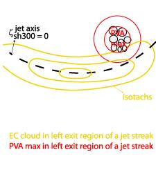
58 Additional parameters for the different wave models: key parameters for rapid cyclogenesis: PVA max in left exit region of a jet stream Where do you assume: a beginning rapid cyclogenesis (yellow star)?
59 Based only on the satellite features: Where do you see waves? Indicate by star
60 Based on the water WV satellite image: Where do you see waves? Indicate by star


61 Key parameters for waves: surface height: Do you assume: an upper wave a wave a rapid cyclogenesis?


62 Key parameters for waves: temperature advection: Do you assume: an upper wave a wave a rapid cyclogenesis?
63 Key parameters for rapid cyclogenesis: Jet streak and PVA Do you assume: a rapid cyclogenesis?
64 Key parameters for rapid cyclogenesis: Jet streak and PVA maximum Do you assume: a rapid cyclogenesis?


65 Key parameters for rapid cyclogenesis: low stratospheric PV Do you assume: a rapid cyclogenesis?
66 Based only on the satellite features: Do you see a comma? Indicate by yellow star
67 Key parameters for a comma: upper level height: Indicate the relevant feature in the 500 hpa Height contours (by star)


68 Key parameters for a comma: PVA Maximum at heigth levels Where do you expect a PVA Maximum at 500 hpa? Indicate by star


69 Key parameters for a comma: maximum of PV down to low levels Where do you expect a PV Maximum? Indicate by star


70 Key parameters fora comma: Jet streak and PVA maximum Where do you expect a left exit region of a jet streak?
71 Enough for today have you any questions Thank you for your co-operation! Useful Exercises till our Langen workshop: I would like you to go through SatManu and the exercises (at least from all CMs which we have treated today) I would like you to prepare a Mini SatRep for the week in Langen. I will put the material in the course page.

72 Thanks for your attention!
Occlusion cyclogenesis II
 Occlusion cyclogenesis II Upper level influences on cyclogenesis Vorticity Advection (CVA) and the 4-quadrant jet streak model (Uccellini) Potential Vorticity (PV) (Hoskins Theory) Rapid cyclogenesis 14
Convective Cloud Features in typical synoptic situations. Frans Debie
 Convective Cloud Features in typical synoptic situations Frans Debie me SATRAPPERS Henk vesa Frans Veronika ab Teachers classroom Langen Cumulonimbus: Convection Convection, seen from ground 1 2 3 4 Outflow
Quasi-Geostrophic Implications
 Chapter 10 Quasi-Geostrophic Implications When you look at a weather chart with all its isolines and plotted data, you need a framework upon which to interpret what you see. Quasi-geostrophic theory provides
Occlusion Cyclogenesis
 Occlusion Cyclogenesis Part I: Occlusion cloud bands in comparison to CF and WFs Concepts for cyclogenesis Different types of cyclogenesis and examples Numerical parameters on isobaric and isentropic surfaces
SATREP Online. Jarno Schipper Zentralanstalt für Meteorologie und Geodynamik, Austria. Vesa Nietosvaara Finnish Met Institute, Finland
 SATREP Online Jarno Schipper Zentralanstalt für Meteorologie und Geodynamik, Austria. Vesa Nietosvaara Finnish Met Institute, Finland SATellite REPort A method of deriving a thorough view of the actual
INTERPRETATION GUIDE TO MSG WATER VAPOUR CHANNELS
 INTERPRETATION GUIDE TO MSG WATER VAPOUR CHANNELS C.G. Georgiev1 and P. Santurette2 1 National Institute of Meteorology and Hydrology, Tsarigradsko chaussee 66, 1784 Sofia, Bulgaria 2 Météo-France, 42,
Mesoscale Atmospheric Systems. Surface fronts and frontogenesis. 06 March 2018 Heini Wernli. 06 March 2018 H. Wernli 1
 Mesoscale Atmospheric Systems Surface fronts and frontogenesis 06 March 2018 Heini Wernli 06 March 2018 H. Wernli 1 Temperature (degc) Frontal passage in Mainz on 26 March 2010 06 March 2018 H. Wernli
1. COLD FRONT - CLOUD STRUCTURE IN SATELLITE IMAGES
 1. COLD FRONT - CLOUD STRUCTURE IN SATELLITE IMAGES The satellite image shows a cyclonically curved synoptic scale cloud band usually a few hundred kilometres wide; in the VIS image the cloud band mostly
Isentropic Analysis. Much of this presentation is due to Jim Moore, SLU
 Isentropic Analysis Much of this presentation is due to Jim Moore, SLU Utility of Isentropic Analysis Diagnose and visualize vertical motion - through advection of pressure and system-relative flow Depict
eport Nataša Strelec Mahović Meteorological and Hydrological Service, Grič 3, Zagreb, Croatia EUMeTrain project Abstract
 eport Nataša Strelec Mahović Meteorological and Hydrological Service, Grič 3, Zagreb, Croatia EUMeTrain project Abstract The paper presents the concept of eport, an interface enabling the combined analysis
The water vapour channels of SEVIRI (Meteosat). An introduction
. An introduction") The water vapour channels of SEVIRI (Meteosat). An introduction jose.prieto@eumetsat.int Cachoeira P. July 2006 Formats 1.5 1 Objectives 2 Describe the characteristics of WV channels on board of SEVIRI
The water vapour channels of SEVIRI (Meteosat). An introduction jose.prieto@eumetsat.int Cachoeira P. July 2006 Formats 1.5 1 Objectives 2 Describe the characteristics of WV channels on board of SEVIRI
Vertical structure. To conclude, we will review the critical factors invloved in the development of extratropical storms.
 Vertical structure Now we will examine the vertical structure of the intense baroclinic wave using three visualization tools: Upper level charts at selected pressure levels Vertical soundings for selected
DANISH METEOROLOGICAL INSTITUTE
 DANISH METEOROLOGICAL INSTITUTE SCIENTIFIC REPORT 3-11 Quasigeostrophic interpretation of extratropical cyclogenesis Niels Woetmann Nielsen COPENHAGEN 23 ISSN Nr. 9-3263 (printed) ISSN Nr. 1399-1949 (online)
SMALL SCALE WV-FEATURE ABOVE FRANCE: NEXT DAY SEVERE WEATHER OVER THE NETHERLANDS
 SMALL SCALE WV-FEATURE ABOVE FRANCE: NEXT DAY SEVERE WEATHER OVER THE NETHERLANDS F.P. Debie KNMI PO Box 201, AE de Bilt, The Netherlands ABSTRACT Due to economic reasons world-wide can be seen that the
EAS372 Open Book Final Exam 11 April, 2013
 EAS372 Open Book Final Exam 11 April, 2013 Professor: J.D. Wilson Time available: 2 hours Value: 30% Please check the Terminology, Equations and Data section before beginning your responses. Answer all
Quasi-Geostrophic ω-equation. 1. The atmosphere is approximately hydrostatic. 2. The atmosphere is approximately geostrophic.
 Quasi-Geostrophic ω-equation For large-scale flow in the atmosphere, we have learned about two very important characteristics:. The atmosphere is approximately hydrostatic.. The atmosphere is approximately
 http://www.ssec.wisc.edu/data/composites.html Red curve: Incoming solar radiation Blue curve: Outgoing infrared radiation. Three-cell model of general circulation Mid-latitudes: 30 to 60 latitude MID-LATITUDES
Fixed Rossby Waves: Quasigeostrophic Explanations and Conservation of Potential Vorticity
 Fixed Rossby Waves: Quasigeostrophic Explanations and Conservation of Potential Vorticity 1. Observed Planetary Wave Patterns After upper air observations became routine, it became easy to produce contour
EAS372 Open Book Final Exam 11 April, 2013
 EAS372 Open Book Final Exam 11 April, 2013 Professor: J.D. Wilson Time available: 2 hours Value: 30% Please check the Terminology, Equations and Data section before beginning your responses. Answer all
u g z = g T y (1) f T Margules Equation for Frontal Slope
 f T Margules Equation for Frontal Slope") Margules Equation for Frontal Slope u g z = g f T T y (1) Equation (1) is the thermal wind relation for the west wind geostrophic component of the flow. For the purposes of this derivation, we assume that
Margules Equation for Frontal Slope u g z = g f T T y (1) Equation (1) is the thermal wind relation for the west wind geostrophic component of the flow. For the purposes of this derivation, we assume that
ERTH 465 Fall Lab 5. Absolute Geostrophic Vorticity. 200 points.
 Name Date ERTH 465 Fall 2015 Lab 5 Absolute Geostrophic Vorticity 200 points. 1. All labs are to be kept in a three hole binder. Turn in the binder when you have finished the Lab. 2. Show all work in mathematical
Introduction to Isentropic Coordinates: a new view of mean meridional & eddy circulations. Cristiana Stan
 Introduction to Isentropic Coordinates: a new view of mean meridional & eddy circulations Cristiana Stan School and Conference on the General Circulation of the Atmosphere and Oceans: a Modern Perspective
Synoptic Meteorology II: Potential Vorticity Inversion and Anomaly Structure April 2015
 Synoptic Meteorology II: Potential Vorticity Inversion and Anomaly Structure 14-16 April 2015 Readings: Sections 4.2 and 4.4 of Midlatitude Synoptic Meteorology. Potential Vorticity Inversion Introduction
Chapter 12 Fronts & Air Masses
 Chapter overview: Anticyclones or highs Air Masses o Classification o Source regions o Air masses of North America Fronts o Stationary fronts o Cold fronts o Warm fronts o Fronts and the jet stream o Frontogenesis
Use of dynamical concepts in weather forecasting
 Use of dynamical concepts in weather forecasting Meteorol. Appl. 4, 345 352 (1997) E B Carroll, Meteorological Office, London Road, Bracknell, Berkshire RG12 2SZ, UK A divergence-based procedure for diagnosing
For the operational forecaster one important precondition for the diagnosis and prediction of
 Initiation of Deep Moist Convection at WV-Boundaries Vienna, Austria For the operational forecaster one important precondition for the diagnosis and prediction of convective activity is the availability
ERTH 465 Fall Lab 5. Absolute Geostrophic Vorticity. 200 points.
 Name Date ERTH 465 Fall 2015 Lab 5 Absolute Geostrophic Vorticity 200 points. 1. All labs are to be kept in a three hole binder. Turn in the binder when you have finished the Lab. 2. Show all work in mathematical
WATER VAPOUR IMAGERY ANALYSIS IN 7.3µ/6.2µ FOR DIAGNOSING THERMO-DYNAMIC CONTEXT OF INTENSE CONVECTION
 WATER VAPOUR IMAGERY ANALYSIS IN 7.3µ/6.2µ FOR DIAGNOSING THERMO-DYNAMIC CONTEXT OF INTENSE CONVECTION P. Santurette 1 and C.G. Georgiev 2 1 Météo-France, 42, Avenue G. Coriolis, 31057 Toulouse Cedex 01,
1. Rossby and Ertel 2. Conservation and invertibility - a useful combination 2.1 Action at a distance
 Met Office College - Course Notes Potential vorticity Contents 1. Rossby and Ertel 2. Conservation and invertibility - a useful combination 2.1 Action at a distance 3. Conceptual models of development
Dynamic Meteorology: lecture 12
 30/11/2018 (Friday) Dynamic Meteorology: lecture 12 Sections 9.5, 9.6 Omega equa)on Large scale ver)cal mo)on in a quasi-geostrophic atmosphere Two level model of the atmosphere 5/12/2017 (Wednesday!!!):
Baroclinic wave. Atmospheric Dynamics: lecture 14 18/12/15. Topics. Chapter 9: Baroclinic waves and cyclogenesis. What is a baroclinic wave?
 Atmospheric Dynamics: lecture 14 (http://www.staff.science.uu.nl/~delde102/) Topics Chapter 9: Baroclinic waves and cyclogenesis What is a baroclinic wave? Quasi-geostrophic equations Omega equation Original
Measurement of Rotation. Circulation. Example. Lecture 4: Circulation and Vorticity 1/31/2017
 Lecture 4: Circulation and Vorticity Measurement of Rotation Circulation Bjerknes Circulation Theorem Vorticity Potential Vorticity Conservation of Potential Vorticity Circulation and vorticity are the
Synoptic-Dynamic Meteorology in Midlatitudes
 Synoptic-Dynamic Meteorology in Midlatitudes VOLUME II Observations and Theory of Weather Systems HOWARD B. BLUESTEIN New York Oxford OXFORD UNIVERSITY PRESS 1993 Contents 1. THE BEHAVIOR OF SYNOPTIC-SCALE,
A SEVERE WEATHER EVENT IN ROMANIA DUE TO MEDITERRANEAN CYCLONIC ACTIVITY
 A SEVERE WEATHER EVENT IN ROMANIA DUE TO MEDITERRANEAN CYCLONIC ACTIVITY Florinela Georgescu, Gabriela Bancila, Viorica Dima National Meteorological Administration, Bucharest, Romania Abstract Mediterranean
Final Examination, MEA 443 Fall 2008, Lackmann
 Place an X here to count it double! Name: Final Examination, MEA 443 Fall 2008, Lackmann If you wish to have the final exam count double and replace your midterm score, place an X in the box above. As
Synoptic Meteorology II: Self-Development in the IPV Framework. 5-7 May 2015
 Synoptic Meteorology II: Self-Development in the IPV Framework 5-7 May 2015 Readings: Section 5.3.6 of Midlatitude Synoptic Meteorology. Introduction In this and other recent lectures, we have developed
Isentropic Analysis. We can look at weather data in other ways besides on constantpressure. Meteorology 411 Iowa State University Week 11 Bill Gallus
 Isentropic Analysis We can look at weather data in other ways besides on constantpressure surfaces! Meteorology 411 Iowa State University Week 11 Bill Gallus A brief history of meteorology In the 1930s
A more detailed and quantitative consideration of organized convection: Part I Cold pool dynamics and the formation of squall lines
 A more detailed and quantitative consideration of organized convection: Part I Cold pool dynamics and the formation of squall lines Note: Lecture notes presented here based on course Daily Weather Laboratory
Dynamics of the Atmosphere. Large-scale flow with rotation and stratification
 12.810 Dynamics of the Atmosphere Large-scale flow with rotation and stratification Visualization of meandering jet stream Upper level winds from June 10th to July 8th 1988 from MERRA Red shows faster
Atmospheric Dynamics: lecture 11
 Atmospheric Dynamics: lecture 11 (http://www.staff.science.uu.nl/~delde102/) Chapter 9 Baroclinic waves and cyclogenesis What is a baroclinic wave? Quasi-geostrophic equations Omega equation Original articles:
AOSC201: Weather and Climate Lab
 AOSC201: Weather and Climate Lab Week 8: Forecasting - Analysis Section 107/108 Instructor: Agniv Sengupta q Lab #7 of Lab Manual (pages 41-49) q 50 points in total q INDIVIDUAL Work for the entire lab
Quasi-geostrophic system
 Quasi-eostrophic system (or, why we love elliptic equations for QGPV) Charney s QG the motion of lare-scale atmospheric disturbances is overned by Laws of conservation of potential temperature and potential
Lec 10: Interpreting Weather Maps
 Lec 10: Interpreting Weather Maps Case Study: October 2011 Nor easter FIU MET 3502 Synoptic Hurricane Forecasts Genesis: on large scale weather maps or satellite images, look for tropical waves (Africa
Using simplified vorticity equation,* by assumption 1 above: *Metr 430 handout on Circulation and Vorticity. Equations (4) and (5) on that handout
 and (5) on that handout") Rossby Wave Equation A. Assumptions 1. Non-divergence 2. Initially, zonal flow, or nearly zonal flow in which u>>v>>w. 3. Initial westerly wind is geostrophic and does not vary along the x-axis and equations
Rossby Wave Equation A. Assumptions 1. Non-divergence 2. Initially, zonal flow, or nearly zonal flow in which u>>v>>w. 3. Initial westerly wind is geostrophic and does not vary along the x-axis and equations
and 24 mm, hPa lapse rates between 3 and 4 K km 1, lifted index values
 3.2 Composite analysis 3.2.1 Pure gradient composites The composite initial NE report in the pure gradient northwest composite (N = 32) occurs where the mean sea level pressure (MSLP) gradient is strongest
THE SYNOPTIC ENVIRONMENT OF THE 11 APRIL 2001 CENTRAL PLAINS TORNADO OUTBREAK VIEWED IN THREE DIMENSIONS
 P1.1 THE SYNOPTIC ENVIRONMENT OF THE 11 APRIL 2001 CENTRAL PLAINS TORNADO OUTBREAK VIEWED IN THREE DIMENSIONS Daniel D. Nietfeld * NOAA/NWS/WFO Omaha/Valley, NE 1. INTRODUCTION A powerful low pressure
Summary of High Wind Event of 7 March 2004
 Summary of High Wind Event of 7 March 2004 This event was characterized by a very strong jet streak that developed over North Carolina by 00 UTC 8 March, as seen in the Eta model analysis at 300 mb, with
Introduction to Isentropic Coordinates:! a new view of mean meridional & eddy circulations" Cristiana Stan
 Introduction to Isentropic Coordinates:! a new view of mean meridional & eddy circulations" Cristiana Stan School and Conference on the General Circulation of the Atmosphere and Oceans: a Modern Perspective!
p = ρrt p = ρr d = T( q v ) dp dz = ρg
 dp dz = ρg") Chapter 1: Properties of the Atmosphere What are the major chemical components of the atmosphere? Atmospheric Layers and their major characteristics: Troposphere, Stratosphere Mesosphere, Thermosphere
Chapter 1: Properties of the Atmosphere What are the major chemical components of the atmosphere? Atmospheric Layers and their major characteristics: Troposphere, Stratosphere Mesosphere, Thermosphere
Modelling the atmosphere. Hennie Kelder University of Technology Eindhoven
 Modelling the atmosphere Hennie Kelder University of Technology Eindhoven Content Basics of the atmosphere Atmospheric dynamics Large scale circulation Planetary waves Brewer-Dobson circulation Some Key
Multiscale Analyses of Inland Tropical Cyclone Midlatitude Jet Interactions: Camille (1969) and Danny (1997)
 and Danny (1997)") Multiscale Analyses of Inland Tropical Cyclone Midlatitude Jet Interactions: Camille (1969) and Danny (1997) Matthew Potter, Lance Bosart, and Daniel Keyser Department of Atmospheric and Environmental
Multiscale Analyses of Inland Tropical Cyclone Midlatitude Jet Interactions: Camille (1969) and Danny (1997) Matthew Potter, Lance Bosart, and Daniel Keyser Department of Atmospheric and Environmental
CONVERGENCE, DIVERGENCE, AND VORTICITY
 CHAPTER 1 CONVERGENCE, DIVERGENCE, AND VORTICITY In your reading of the AG2 manual, volume 1, you became familiar with the terms convergence, divergence, and vorticity when used in relation to surface
BALANCED FLOW: EXAMPLES (PHH lecture 3) Potential Vorticity in the real atmosphere. Potential temperature θ. Rossby Ertel potential vorticity
 Potential Vorticity in the real atmosphere. Potential temperature θ. Rossby Ertel potential vorticity") BALANCED FLOW: EXAMPLES (PHH lecture 3) Potential Vorticity in the real atmosphere Need to introduce a new measure of the buoyancy Potential temperature θ In a compressible fluid, the relevant measure
BALANCED FLOW: EXAMPLES (PHH lecture 3) Potential Vorticity in the real atmosphere Need to introduce a new measure of the buoyancy Potential temperature θ In a compressible fluid, the relevant measure
True or false: The atmosphere is always in hydrostatic balance. A. True B. False
 Clicker Questions and Clicker Quizzes Clicker Questions Chapter 7 Of the four forces that affect the motion of air in our atmosphere, which is to thank for opposing the vertical pressure gradient force
EasyChair Preprint. Sotirios Tsiougkos and Dimitrios Brikas. November 9, 2018
 EasyChair Preprint 616 Calculation of dynamic and thermodynamic parameters from spatial data of high spatial resolution of a weather event s specific case study event that occurred on the 16th and 17th
1/18/2011. From the hydrostatic equation, it is clear that a single. pressure and height in each vertical column of the atmosphere.
 Lecture 3: Applications of Basic Equations Pressure as Vertical Coordinate From the hydrostatic equation, it is clear that a single valued monotonic relationship exists between pressure and height in each
Module 11: Meteorology Topic 5 Content: Weather Maps Notes
 Introduction A variety of weather maps are produced by the National Weather Service and National Oceanographic Atmospheric Administration. These maps are used to help meteorologists accurately predict
The dynamics of high and low pressure systems
 The dynamics of high and low pressure systems Newton s second law for a parcel of air in an inertial coordinate system (a coordinate system in which the coordinate axes do not change direction and are
McGraw Hill Yearbook of Science & Technology Extratropical cyclone occlusion. McGraw Hill 2008 Yearbook of Science & Technology.
 McGraw Hill Yearbook of Science & Technology 0 Extratropical cyclone occlusion Journal: McGraw Hill 0 Yearbook of Science & Technology Manuscript ID: draft Manuscript Type: Date Submitted by the Author:
The Potential Role of a Stratospheric Intrusion in the March 7, 2004, High Wind Event
 The Potential Role of a Stratospheric Intrusion in the March 7, 2004, High Wind Event Dry downbursts are rather rare in North Carolina, so the high wind event of Sunday, March 7, 2004, merits particular
The Impact of air-sea interaction on the extratropical transition of tropical cyclones
 The Impact of air-sea interaction on the extratropical transition of tropical cyclones Sarah Jones Institut für Meteorologie und Klimaforschung Universität Karlsruhe / Forschungszentrum Karlsruhe 1. Introduction
The Behaviour of the Atmosphere
 3 The Behaviour of the Atmosphere Learning Goals After studying this chapter, students should be able to: apply the ideal gas law and the concept of hydrostatic balance to the atmosphere (pp. 49 54); apply
Atmospheric dynamics and meteorology
 Atmospheric dynamics and meteorology B. Legras, http://www.lmd.ens.fr/legras III Frontogenesis (pre requisite: quasi-geostrophic equation, baroclinic instability in the Eady and Phillips models ) Recommended
Rapid cyclogenesis over Poland on 28 March 1997
 Meteorol. Appl. 6, 363 370 (1999) Rapid cyclogenesis over Poland on 28 March 1997 Jan Waclaw Parfiniewicz, Institute of Meteorology and Water Management, ul. Podleœna 61, 01 673 Warszawa, Poland A small
Dynamic Meteorology 1
 Dynamic Meteorology 1 Lecture 14 Sahraei Department of Physics, Razi University http://www.razi.ac.ir/sahraei Buys-Ballot rule (Northern Hemisphere) If the wind blows into your back, the Low will be to
AOS 452 Lab 13 Handout Upper-Level Frontogenesis and Sawyer-Eliassen Circulations
 AOS 452 Lab 13 Handout Upper-Level Frontogenesis and Sawyer-Eliassen Circulations Introduction As we discussed in class, fronts are locations at which we cannot ignore the effects of ageostrophy. Furthermore,
Meteorology Lecture 15
 Meteorology Lecture 15 Robert Fovell rfovell@albany.edu 1 Important notes These slides show some figures and videos prepared by Robert G. Fovell (RGF) for his Meteorology course, published by The Great
Hydrostatic Equation and Thermal Wind. Meteorology 411 Iowa State University Week 5 Bill Gallus
 Hydrostatic Equation and Thermal Wind Meteorology 411 Iowa State University Week 5 Bill Gallus Hydrostatic Equation In the atmosphere, vertical accelerations (dw/dt) are normally fairly small, and we can
Examples of Pressure Gradient. Pressure Gradient Force. Chapter 7: Forces and Force Balances. Forces that Affect Atmospheric Motion 2/2/2015
 Chapter 7: Forces and Force Balances Forces that Affect Atmospheric Motion Fundamental force - Apparent force - Pressure gradient force Gravitational force Frictional force Centrifugal force Forces that
Mid-Latitude Cyclones and Fronts. Lecture 12 AOS 101
 Mid-Latitude Cyclones and Fronts Lecture 12 AOS 101 Homework 4 COLDEST TEMPS GEOSTROPHIC BALANCE Homework 4 FASTEST WINDS L Consider an air parcel rising through the atmosphere The parcel expands as it
1.4 CONNECTIONS BETWEEN PV INTRUSIONS AND TROPICAL CONVECTION. Beatriz M. Funatsu* and Darryn Waugh The Johns Hopkins University, Baltimore, MD
 1.4 CONNECTIONS BETWEEN PV INTRUSIONS AND TROPICAL CONVECTION Beatriz M. Funatsu* and Darryn Waugh The Johns Hopkins University, Baltimore, MD 1. INTRODUCTION Stratospheric intrusions into the tropical
Eliassen-Palm Theory
 Eliassen-Palm Theory David Painemal MPO611 April 2007 I. Introduction The separation of the flow into its zonal average and the deviations therefrom has been a dominant paradigm for analyses of the general
Weather report 28 November 2017 Campinas/SP
 Weather report 28 November 2017 Campinas/SP Summary: 1) Synoptic analysis and pre-convective environment 2) Verification 1) Synoptic analysis and pre-convective environment: At 1200 UTC 28 November 2017
Meteorology Master s Thesis A CRITICAL ASSESSMENT OF OCCLUDED FRONTS. Alessandro Chiariello Supervisor: Aulikki Lehkonen
 Meteorology Master s Thesis A CRITICAL ASSESSMENT OF OCCLUDED FRONTS Alessandro Chiariello 21.11.2006 Supervisor: Aulikki Lehkonen Reviewers: Hannu Savijärvi, Aulikki Lehkonen UNIVERSITY OF HELSINKI DEPARTMENT
Isentropic Thinking & Airstreams Analysis
 Isentropic Thinking & Airstreams Analysis Drs. James T. Moore & Sam Ng Saint Louis University & Metropolitan State College of Denver Utility of Isentropic Analysis Diagnose and visualize vertical motion
Project 2 Fronts
 12.307 Project 2 Fronts Lodovica Illari and John Marshall March 2010 Abstract We inspect fronts crossing the country associated with day-to-day variations in the weather using real-time atmospheric observations.
Relationships between the North Atlantic Oscillation and isentropic water vapor transport into the lower stratosphere
 1/18 Relationships between the North Atlantic Oscillation and isentropic water vapor transport into the lower stratosphere Jonathon Wright and Seok-Woo Son Department of Applied Physics & Applied Mathematics
Lecture 1. Equations of motion - Newton s second law in three dimensions. Pressure gradient + force force
 Lecture 3 Lecture 1 Basic dynamics Equations of motion - Newton s second law in three dimensions Acceleration = Pressure Coriolis + gravity + friction gradient + force force This set of equations is the
Geopotential tendency and vertical motion
 Geopotential tendency and vertical motion Recall PV inversion Knowin the PV, we can estimate everythin else! (Temperature, wind, eopotential ) In QG, since the flow is eostrophic, we can obtain the wind
The Impact of the Extratropical Transition of Typhoon Dale (1996) on the Early Wintertime Stratospheric Circulation
 on the Early Wintertime Stratospheric Circulation") The Impact of the Extratropical Transition of Typhoon Dale (1996) on the Early 1996-97 Wintertime Stratospheric Circulation Andrea L. Lang 1, Jason M. Cordeira 2, Lance F. Bosart 1 and Daniel Keyser 1
The Impact of the Extratropical Transition of Typhoon Dale (1996) on the Early 1996-97 Wintertime Stratospheric Circulation Andrea L. Lang 1, Jason M. Cordeira 2, Lance F. Bosart 1 and Daniel Keyser 1
Vorticity in natural coordinates
 Vorticity in natural coordinates (see Holton pg 95, section 4.2.) Let s consider the vertical vorticity component only, i.e. ζ kˆ ω, we have ω u dl kˆ ω lim --- lim ----------------- curve is in xy plane
Lecture #2 Planetary Wave Models. Charles McLandress (Banff Summer School 7-13 May 2005)
") Lecture #2 Planetary Wave Models Charles McLandress (Banff Summer School 7-13 May 2005) 1 Outline of Lecture 1. Observational motivation 2. Forced planetary waves in the stratosphere 3. Traveling planetary
Lecture #2 Planetary Wave Models Charles McLandress (Banff Summer School 7-13 May 2005) 1 Outline of Lecture 1. Observational motivation 2. Forced planetary waves in the stratosphere 3. Traveling planetary
AN EXTRATROPICAL CYCLONE ATLAS
 AN EXTRATROPICAL CYCLONE ATLAS A tool for illustrating cyclone structure and evolution characteristics BY H. F. DACRE, M. K. HAWCROFT, M. A. STRINGER AND K. I. HODGES Authors Affiliations H.F.Dacre, Department
The General Circulation of the Atmosphere: A Numerical Experiment
 The General Circulation of the Atmosphere: A Numerical Experiment Norman A. Phillips (1956) Presentation by Lukas Strebel and Fabian Thüring Goal of the Model Numerically predict the mean state of the
Mesoscale Meteorology Assignment #3 Q-G Theory Exercise. Due 23 February 2017
 Mesoscale Meteorology Assignment #3 Q-G Theory Exercise 1. Consider the sounding given in Fig. 1 below. Due 23 February 2017 Figure 1. Skew T-ln p diagram from Tallahassee, FL (TLH). The observed temperature
1/25/2010. Circulation and vorticity are the two primary
 Lecture 4: Circulation and Vorticity Measurement of Rotation Circulation Bjerknes Circulation Theorem Vorticity Potential Vorticity Conservation of Potential Vorticity Circulation and vorticity are the
Circulation and Vorticity
 Circulation and Vorticity Example: Rotation in the atmosphere water vapor satellite animation Circulation a macroscopic measure of rotation for a finite area of a fluid Vorticity a microscopic measure
Boundary layer controls on extratropical cyclone development
 Boundary layer controls on extratropical cyclone development R. S. Plant (With thanks to: I. A. Boutle and S. E. Belcher) 28th May 2010 University of East Anglia Outline Introduction and background Baroclinic
On the effect of forward shear and reversed shear baroclinic flows for polar low developments. Thor Erik Nordeng Norwegian Meteorological Institute
 On the effect of forward shear and reversed shear baroclinic flows for polar low developments Thor Erik Nordeng Norwegian Meteorological Institute Outline Baroclinic growth a) Normal mode solution b) Initial
Synoptic Meteorology
 M.Sc. in Meteorology Synoptic Meteorology [MAPH P312] Prof Peter Lynch Second Semester, 2004 2005 Seminar Room Dept. of Maths. Physics, UCD, Belfield. Part 9 Extratropical Weather Systems These lectures
Dynamics of the Extratropical Response to Tropical Heating
 Regional and Local Climate Modeling and Analysis Research Group R e L o C l i m Dynamics of the Extratropical Response to Tropical Heating (1) Wegener Center for Climate and Global Change (WegCenter) and
GH = Differential temperature advection term
 QG Theory and Applications: Height Tendency Equation Atmos 5110 Synoptic Dynamic Meteorology I Instructor: Jim Steenburgh jim.steenburgh@utah.edu 801-581-8727 Suite 480/Office 488 INSCC Suggested reading:
A Cyclogenesis south of the Alps. Manfred Kurz Neustadt/Weinstraße
 A Cyclogenesis south of the Alps Manfred Kurz Neustadt/Weinstraße A cyclogenesis south of the Alps Surface maps 06-11-99, 00 UTC The occluded frontal system of a quasi-stationary low above the North Sea
A case of Rapid Cyclogenesis over Ionian Sea on February 6 th, 2012
 Author: Kyriaki Metheniti, HNMS Showcase Title: A case of Rapid Cyclogenesis Time frame: February 6 to February 7, 2012 Study region: Eastern Mediterranean, Ionian Sea A case of Rapid Cyclogenesis over
The Planetary Circulation System
 12 The Planetary Circulation System Learning Goals After studying this chapter, students should be able to: 1. describe and account for the global patterns of pressure, wind patterns and ocean currents
General Circulation. Nili Harnik DEES, Lamont-Doherty Earth Observatory
 General Circulation Nili Harnik DEES, Lamont-Doherty Earth Observatory nili@ldeo.columbia.edu Latitudinal Radiation Imbalance The annual mean, averaged around latitude circles, of the balance between the
Synoptic Meteorology I: Skew-T Diagrams and Thermodynamic Properties
 Synoptic Meteorology I: Skew-T Diagrams and Thermodynamic Properties For Further Reading Most information contained within these lecture notes is drawn from Chapters 1, 2, 4, and 6 of The Use of the Skew
Mid-Latitude Dynamics and Atmospheric Rivers
 Mid-Latitude Dynamics and Atmospheric Rivers Session: Theory, Structure, Processes 1 Wednesday, 10 August 2016 Contribution from: Heini Werni Peter Knippertz Harold Sodemann Andreas Stohl Francina Dominguez
QUALITY OF MPEF DIVERGENCE PRODUCT AS A TOOL FOR VERY SHORT RANGE FORECASTING OF CONVECTION
 QUALITY OF MPEF DIVERGENCE PRODUCT AS A TOOL FOR VERY SHORT RANGE FORECASTING OF CONVECTION C.G. Georgiev 1, P. Santurette 2 1 National Institute of Meteorology and Hydrology, Bulgarian Academy of Sciences
Fall 2015 Laboratory 7 Quasigeostrophic Forcing Functions 300 points. You are provided with the following for 12 UTC 12/4/12 (a) WRF-NAM
 WRF-NAM") ERTH 465 Fall 2015 Laboratory 7 NAME Quasigeostrophic Forcing Functions 300 points. You are provided with the following for 12 UTC 12/4/12 (a) WRF-NAM initialization of SLP and 1000-500 mb thickness; (b)
ERTH 465 Fall 2015 Laboratory 7 NAME Quasigeostrophic Forcing Functions 300 points. You are provided with the following for 12 UTC 12/4/12 (a) WRF-NAM initialization of SLP and 1000-500 mb thickness; (b)