McGraw Hill Yearbook of Science & Technology Extratropical cyclone occlusion. McGraw Hill 2008 Yearbook of Science & Technology.
|
|
|
- Jonah Richardson
- 5 years ago
- Views:
Transcription
1 McGraw Hill Yearbook of Science & Technology 0 Extratropical cyclone occlusion Journal: McGraw Hill 0 Yearbook of Science & Technology Manuscript ID: draft Manuscript Type: Date Submitted by the Author: Complete List of Authors: Keywords: Yearbook Article n/a Martin, Jonathan; University of Wisconsin-Madison, Atmospheric and Oceanic Sciences extratropical cyclone, fronts, frontal structure, occlusion, trowal Abstract: The notion of extratropical cyclone occlusion has been controversial since it was first proposed just after World War I. Recent advances in understanding the dynamics of occlusion as well as modern means of interrogating its characteristic structure are reviewed. Among the various concepts explored are ) the use of high resolution numerical model output in revitalizing old conceptual ideas such as the trowal; ) the role of rotational frontogenesis and its associated vertical circulation in the dynamics of the occluded quadrant; ) the funadmental role of latent heat release in the occlusion process; and ) the influence of the extratropical occlusion process on the development of a subset of tropical cyclones.
2 Page of McGraw Hill Yearbook of Science & Technology 0 0 EXTRATROPICAL CYCLONE OCCLUSION by JONATHAN E. MARTIN Department of Atmospheric and Oceanic Sciences University of Wisconsin-Madison W. Dayton Street Madison, WI The largest fraction of what is colloquially referred to as weather in the extratropics is delivered by the development and propagation of mid-latitude weather systems. These disturbances, commonly referred to as lows and highs develop in response to a fundamental instability of the westerlies, known as baroclinic instability, that arises as a consequence of the permanent but seasonally modulated pole-to-equator temperature contrast. The lows in this endless sequence of disturbances are known as mid-latitude cyclones. Though sporadic insights into their structure and dynamics have been accumulated for nearly 0 years, systematic study of the mid-latitude cyclone did not commence until just after World War I. The Norwegian Cyclone Model The relationship between the three-dimensional thermal structure and the distribution of clouds and precipitation in these cyclones was first suggested by Bjerknes and Solberg in in their conceptual model of the mid-latitude cyclone, which has come to be known as the Norwegian Cyclone Model (NCM). The genius of this conceptual model was that it placed the instantaneous structure of the cyclone into the context of an identifiable life cycle. According to the NCM, extratropical cyclones developed as infinitesimally small perturbations along a pre-existing, globe-girdling
3 McGraw Hill Yearbook of Science & Technology 0 Page of 0 discontinuity in temperature known as the polar front which separated tropical air from polar air. Horizontal temperature advection associated with the initial perturbation converted available potential energy (APE) into eddy kinetic energy (EKE) and led to the amplification of the storm which, in turn, distorted the polar front into a cold front and a warm front and left a region of homogeneous warm air extending downward to the surface between the two fronts. This region was known as the warm sector and the air there known as warm sector air (Fig. a). Occlusion The NCM suggests that as the cyclone reaches its mature phase, with continued intensification and frontal distortion, the fronts catch up with one another instigating a cutting off of the cyclone center from the peak of the warm sector in what was termed the occlusion of the cyclone. Often a surface boundary remains after occlusion has occurred and this boundary is referred to as an occluded front. Occluded fronts were thought to occur in two varieties; the cold occlusion and the warm occlusion differentiated based upon whether the air poleward of the warm front was more dense (warm occlusion) or less dense (cold occlusion) than the air behind the cold front. Emphasis on the surface occluded boundary is, however, misplaced and distracting as consideration of a fully D occluded structure offers the most comprehensive insights into the structural and dynamical evolution of the post-mature phase extratropical cyclone. The warm occlusion process described the vertical displacement of warm sector surface air that resulted from the cold front overtaking, and subsequently ascending, the warm frontal surface. One of the main results of this process was the production of a wedge of warm air aloft, displaced poleward of the surface warm and occluded fronts.
4 Page of McGraw Hill Yearbook of Science & Technology 0 0 The cloudiness and precipitation associated with the development of the warm occlusion were suggested to result from lifting of warm air ahead of the upper cold front and were consequently distributed to the north and west of the sea-level pressure minimum. Further, as a result of the gradual squeezing of warm air aloft between the two frontal surfaces, the horizontal thermal structure of warm occlusions was characterized by a thermal ridge connecting the peak of the warm sector to the geopotential or sea-level pressure minimum. In nature, this thermal ridge is often manifested as a hpa thickness ridge or as an axis of maximum potential temperature () or equivalent potential temperature ( e ) in a horizontal cross-section and is referred to as the occluded thermal ridge (Fig. b). Structure of Occluded Cyclones Cyclones are D entities and in the development stage the surface cyclone center, or sea-level pressure minimum, lies to the east of its companion upper-level cyclone center. Such a structure ensures that upward vertical motion, which occurs east of upperlevel cyclones, will be located directly above the sea-level pressure minimum. This upward vertical motion not only leads directly to the production of clouds and precipitation, but also evacuates mass from the column of air thereby lowering the sealevel pressure and intensifying the circulation of the developing storm. As the cyclone approaches the occluded stage, the surface and upper-level cyclones become more vertically stacked. This reduces both the temperature contrasts and vertical wind shear in the vicinity of the surface cyclone. The displacement of the most intense upward vertical motion to the east away from the sea-level pressure minimum also inhibits additional
5 McGraw Hill Yearbook of Science & Technology 0 Page of 0 development of the surface cyclone center. Hence, occlusion often heralds the commencement of cyclone decay. A representative vertical cross-section perpendicular to the axis of an occluded thermal ridge reveals the characteristic thermal structure of a warm occlusion which consists of a poleward sloping axis of maximum e separating two regions of concentrated temperature contrast, or baroclinicity (Fig. ). The surface warm occluded front is generally analyzed at the location where the axis of maximum e intersects the ground whereas the base of the warm air wedge between the two frontal zones (the cold and warm fronts) sits atop their point of intersection. An alternative means of depicting the warm occluded thermal structure is by considering the topography (geometric or isobaric) of an appropriate e surface selected from a vertical cross section such as that depicted in Fig.. In that section, the 0 K e isentrope lies near the warm edge of both the cold and warm frontal zones comprising the warm occluded structure. The geometric topography of a similarly selected e surface illustrates the steep slope of the cold frontal zone and the shallower slope of the warm frontal zone (Fig. ). Also evident is a notch in the topography that pokes upward from low levels over central Illinois to northwestern Missouri. This canyon in the K e surface represents the region of overlap of the warm and cold fronts of the warm occluded structure. With less sophisticated analysis tools at their disposal, scientists at the Canadian Meteorological Service in the s and s observed that the cloudiness and precipitation characteristic of the occluded quadrant of cyclones often occurs in the vicinity of the thermal ridge. This led them to regard the essential structural feature of a
6 Page of McGraw Hill Yearbook of Science & Technology 0 0 warm occlusion to be the wedge of warm air that is lifted aloft ahead of the upper cold front, not the position of the surface occluded front. These studies suggested that the location of a feature called the trowal (trough of warm air aloft) often bore a closer correspondence to the cloud and precipitation features of occluded cyclones in North America than did the often weak surface warm occluded front. The trowal conceptual model actually represents an extension of the classical occlusion model in that it draws formal attention to the wedge of warm air that is displaced poleward and upward during the occlusion process. The trowal has variously been considered a line connecting the crest of the thermal wave at successive heights as well as a sloping valley of tropical air aloft or, alternatively, the canyon in the K e surface depicted in Fig.. It might best be considered as the -D sloping intersection of the upper cold fontal portion of the warm occlusion with the warm frontal zone (Fig. ). Compelling evidence supporting these observational findings comes from a number of recent fine-scale numerical modeling studies of occluded cyclones which have illustrated the structure and thermal evolution of, and airflow through, the occluded quadrant. These studies have identified a coherent airstream, referred to by the author as the trowal airstream that originates in the warm sector boundary layer, and ascends cyclonically in the occluded quadrant of the cyclone. This ascent is responsible for the production of the characteristic cloud and precipitation distribution in the occluded quadrant of middle latitude cyclones. Dynamics of Occluded Cyclones Although extensive investigation of the trowal was made in Canada in the s and s, its relationship to the distribution of clouds and precipitation in the occluded quadrant of cyclones was understood in terms of relative flow along what were
7 McGraw Hill Yearbook of Science & Technology 0 Page of 0 considered material frontal surfaces comprising the occluded structure and not as a consequence of some characteristic dynamical process. In, Morris recognized the trowal was.. a discontinuity in the thermal advection field.. and correctly pointed out that such a feature has dynamical significance with respect to the diagnosis of vertical motion. Another dynamical approach to understanding the forcing for upward vertical motion in the occluded quadrant arises from considering Lagrangian changes in the potential temperature gradient vector. Given the asymmetric, frontal nature of the thermal structure of an extratropical cyclone, its evolution is the integrated result of ) changes in the vigor of each baroclinic zone as well as ) changes in the orientation of the baroclinic zones to one another, both of which occur continuously throughout the cyclone life cycle. Changes in the intensity of baroclinic zones are controlled by a process known as scalar frontogenesis which modulates the magnitude of the potential temperature gradient and operates on the scale of the individual baroclinic zones. This process is dynamically linked to the production of banded couplets of vertical motion that straddle the baroclinic zone (i.e. fronts) and are manifest in the front-parallel bands of clouds and precipitation commonly associated with fronts. Changes in the orientation of the frontal zones with respect to one another are a result of rotation of the potential temperature gradient vector forced by a process known as rotational frontogenesis. This physical process also has an associated vertical circulation in which couplets of upward and downward vertical motion are distributed along the baroclinic zones. In Martin showed through analysis of three different cases that the characteristic occluded thermal ridge is produced by differential rotation of the warm and
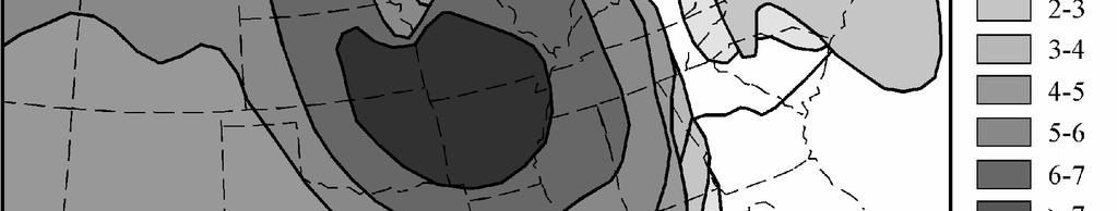
8 Page of McGraw Hill Yearbook of Science & Technology 0 0 cold frontal baroclinic zones about the cyclone center during the cyclone life cycle. In fact, rotational frontogenesis was found to be the underlying dynamical mechanism responsible for simultaneously creating the characteristic occluded thermal ridge and for forcing the majority of the upward vertical air motions within the occluded thermal ridge of the cyclones. In light of this result, the view of the occlusion process, which had been considered to be rooted in traditional, meso-scale frontal dynamics, was reconceptualized as proceeding from the larger synoptic-scale processes that govern the progression of the cyclone through its life cycle. Latent heat release and the occlusion process Examination of the tropopause-level distribution of potential vorticity (PV) offers yet another means of identifying a warm occluded structure and is, in fact, a useful starting point for a discussion of the influence of latent heat release in the evolution of warm occluded thermal structures. The PV distribution at tropopause level often takes on a treble clef shape consisting of an isolated, low-latitude high PV feature that is connected to a high latitude reservoir of high PV by a rather thin filament of high PV (Fig. ). This same shape appears in the isobaric or geometric height topography of the e surface that lies closest to the warm edges of both the cold and warm frontal zones of the warm occluded thermal structure, particularly above about km (Fig. ). Such morphological similarity between these two fields is not case specific but instead is a general consequence of the characteristic thermodynamic structure associated with a positive PV anomaly at the tropopause in which tropospheric isentropes bend upward toward the anomaly while stratospheric isentropes bow downward towards it (Fig. a). Thus, regions of large tropopause-level PV sit atop relatively cold columns of air while
9 McGraw Hill Yearbook of Science & Technology 0 Page of 0 relative minima in upper-level PV sit atop relatively warm columns of air. The characteristic thermal structure associated with the horizontal juxtaposition of two upperlevel PV anomalies of unequal magnitude, separated by a relative minimum in PV, exhibits an axis of maximum beneath the PV minimum that separates two distinct regions of tropospheric baroclinicity (Fig. b). This structure precisely depicts that of a warm occlusion and is a hydrostatic consequence of the treble clef shaped upper-level PV structure. Thus, the treble clef tropopause-level PV distribution, such as in shown in Fig., is a sufficient condition for asserting the presence of warm occluded thermal structure in the underlying troposphere. If one accepts the proposition that the essential structural characteristic of the occluded cyclone is the trowal, then it follows that the occlusion process might reasonably be defined as the process(es) by which a cyclone acquires the trowal/treble clef structure. In 0, Martin and Posselt compared companion numerical simulations of the same occluded storm; one run with a full physics (FP) package in the model code, and the other run while withholding the occurrence and associated feedbacks from latent heat release (NLHR). They employed calculations of the diabatic PV tendency and demonstrated that the initial development of the low PV notch in the treble clef structure was a direct consequence of dilution of upper tropospheric PV resulting from latent heat release in the occluded quadrant. As this dilution began to carve out the treble-clef notch, the low latitude PV feature became progressively more isolated from the higher latitude reservoir. This cutting off process, in turn, isolated the tropopause-level cyclonic circulation associated with the low latitude PV feature. As a consequence, the advection of low PV by the tropopause-level winds contributed to the rapid growth of the PV notch
10 Page of McGraw Hill Yearbook of Science & Technology 0 0 during the late stages of the life cycle. Though they identified a background adiabatic, kinematic tendency to produce an upper tropospheric PV treble clef in that case, the resulting NLHR treble clef structure was much weaker and slower to develop than the structure present in the FP simulation. They concluded that latent heat release plays a fundamental role in the development of the occluded thermal structure and, therefore, in the occlusion process itself. Taken as a whole, these results served to extend an emerging dynamic/conceptual model of the occlusion process by providing evidence that it depends upon the interaction of a characteristic dynamical forcing for upward vertical motion and the latent heat release that results from that upward vertical motion. In contrast, the cold and warm frontal structures that develop in mid-latitude cyclones are a consequence of scalar frontogenesis and are not greatly altered in their essential structural characteristics by the release of latent heat that characterizes them. The fact that the development of an occluded thermal structure appears to depend so intimately on latent heat release further highlights the fundamentally different nature of the occlusion process as compared to traditional frontogenesis. It appears increasingly clear to the author that further insight into the nature of the occlusion process will arise only when it is no longer viewed as a traditional frontal process. Occlusion and tropical cyclones On occasion, upper tropopsheric, middle latitude, wave disturbances can migrate sufficiently equatorward to spawn an extratropical surface cyclone in the subtropics. In such a case, the role of latent heat release is enhanced as a consequence of the greater abundance of water vapor, especially over the subtropical ocean. The interaction between enhanced latent heat release and the natural progression toward occlusion can
11 McGraw Hill Yearbook of Science & Technology 0 Page 0 of 0 lead to a fairly abrupt erosion of upper-level PV, a reduction in vertical wind shear and an elimination of baroclinicity. All three of these processes tend to reduce the available potential energy which, at middle latitudes, results in a gradual but decided weakening of the storm. If the subtropical storm occludes over a warm enough ocean, then the removal of the vertical shear coupled with enhanced convection offer the storm an alternative mechanism for continued development - air-sea interaction and wind induced surface heat exchange (WISHE); an energy transfer mechanism that fuels the growth of tropical cyclones. Thus, the occlusion process likely plays a role in instigating the transformation of extratropical cyclones into tropical cyclones; a process known as tropical transition. Current research seeks to better understand the physical connections between the canonical occlusion process, deep subtropical convection, and tropical transitions. These exciting developments suggest that the process of occlusion, once assumed to be relevant only for mid-latitude storms, likely plays a role in the life cycles of a broader class of cyclonic systems. KEYWORDS: extratropical cyclone, fronts, frontal structure, occlusion, trowal WIDELY AVAILABLE GENERAL TEXTS: ) Jonathan E. Martin, Mid-Latitude Atmospheric Dynamics: A First Course, 0. ) Howard B. Bluestein, Synoptic-Dynamic Meteorology in Midlatitudes, Volume II,. ) James R. Holton, An Introduction to Dynamic Meteorology, Fourth Edition, 0. ADDITIONAL READINGS
12 Page of McGraw Hill Yearbook of Science & Technology 0 0 ) Schultz, D. and C. F. Mass, : The occlusion process in a midlatitude cyclone over land. Mon. Wea. Rev.,, -. ) Martin, J. E., : The structure and evolution of a continental winter cyclone. Part I: Frontal structure and the occlusion process. Mon Wea. Rev.,, -. ) Martin, J. E., : Quasigeostrophic forcing for ascent in the occluded sector of cyclones and the trowal airstream. Mon. Wea. Rev.,, 0-. ) Stoelinga, M. T., J. D. Locatelli, and P. V. Hobbs, 0: Warm occlusions, cold occlusions, and forward tilting cold fronts. Bull. Amer. Meteor. Soc.,, 0-. ) Posselt, D. J., and J. E. Martin, 0: The effect of latent heat release on the evolution of a warm occluded thermal structure. Mon. Wea. Rev.,, -. WEBSITES OF INTEREST ) This page illustrates results of the January case analysis by Martin () with air parcel trajectories and thermodynamic analyses. ) This page illustrates a variety of trajectories that support the analysis presented in Martin ().


13 McGraw Hill Yearbook of Science & Technology 0 Page of 0


14 Page of McGraw Hill Yearbook of Science & Technology 0 0


15 McGraw Hill Yearbook of Science & Technology 0 Page of 0


16 Page of McGraw Hill Yearbook of Science & Technology 0 0


17 McGraw Hill Yearbook of Science & Technology 0 Page of 0


18 Page of McGraw Hill Yearbook of Science & Technology 0 0
Synoptic Meteorology II: Self-Development in the IPV Framework. 5-7 May 2015
 Synoptic Meteorology II: Self-Development in the IPV Framework 5-7 May 2015 Readings: Section 5.3.6 of Midlatitude Synoptic Meteorology. Introduction In this and other recent lectures, we have developed
10B.2 THE ROLE OF THE OCCLUSION PROCESS IN THE EXTRATROPICAL-TO-TROPICAL TRANSITION OF ATLANTIC HURRICANE KAREN
 10B.2 THE ROLE OF THE OCCLUSION PROCESS IN THE EXTRATROPICAL-TO-TROPICAL TRANSITION OF ATLANTIC HURRICANE KAREN Andrew L. Hulme* and Jonathan E. Martin University of Wisconsin-Madison, Madison, Wisconsin
Lower-Tropospheric Height Tendencies Associated with the Shearwise and Transverse Components of Quasigeostrophic Vertical Motion
 JULY 2007 N O T E S A N D C O R R E S P O N D E N C E 2803 Lower-Tropospheric Height Tendencies Associated with the Shearwise and Transverse Components of Quasigeostrophic Vertical Motion JONATHAN E. MARTIN
Chapter 12 Fronts & Air Masses
 Chapter overview: Anticyclones or highs Air Masses o Classification o Source regions o Air masses of North America Fronts o Stationary fronts o Cold fronts o Warm fronts o Fronts and the jet stream o Frontogenesis
Synoptic-Dynamic Meteorology in Midlatitudes
 Synoptic-Dynamic Meteorology in Midlatitudes VOLUME II Observations and Theory of Weather Systems HOWARD B. BLUESTEIN New York Oxford OXFORD UNIVERSITY PRESS 1993 Contents 1. THE BEHAVIOR OF SYNOPTIC-SCALE,
 http://www.ssec.wisc.edu/data/composites.html Red curve: Incoming solar radiation Blue curve: Outgoing infrared radiation. Three-cell model of general circulation Mid-latitudes: 30 to 60 latitude MID-LATITUDES
Transient and Eddy. Transient/Eddy Flux. Flux Components. Lecture 3: Weather/Disturbance. Transient: deviations from time mean Time Mean
 Lecture 3: Weather/Disturbance Transients and Eddies Climate Roles Mid-Latitude Cyclones Tropical Hurricanes Mid-Ocean Eddies Transient and Eddy Transient: deviations from time mean Time Mean Eddy: deviations
Synoptic Meteorology
 M.Sc. in Meteorology Synoptic Meteorology [MAPH P312] Prof Peter Lynch Second Semester, 2004 2005 Seminar Room Dept. of Maths. Physics, UCD, Belfield. Part 9 Extratropical Weather Systems These lectures
Air Masses of North America cp and ca air masses Air mass characterized by very cold and dry conditions
 Chapter 8: Air Masses, Fronts, and Middle-Latitude Cyclones Air masses Fronts Middle-latitude cyclones Air Masses Air mass an extremely large body of air whose properties of temperature and humidity are
and 24 mm, hPa lapse rates between 3 and 4 K km 1, lifted index values
 3.2 Composite analysis 3.2.1 Pure gradient composites The composite initial NE report in the pure gradient northwest composite (N = 32) occurs where the mean sea level pressure (MSLP) gradient is strongest
Meteorology 311. General Circulation/Fronts Fall 2017
 Meteorology 311 General Circulation/Fronts Fall 2017 Precipitation Types Rain Snow growth of ice crystals through deposition, accretion, and aggregation. Freezing Rain Rain freezes when it hits the surface.
Meteorology Master s Thesis A CRITICAL ASSESSMENT OF OCCLUDED FRONTS. Alessandro Chiariello Supervisor: Aulikki Lehkonen
 Meteorology Master s Thesis A CRITICAL ASSESSMENT OF OCCLUDED FRONTS Alessandro Chiariello 21.11.2006 Supervisor: Aulikki Lehkonen Reviewers: Hannu Savijärvi, Aulikki Lehkonen UNIVERSITY OF HELSINKI DEPARTMENT
AIR MASSES SOURCE REGION CHARACTERISTICS Continental Arctic (ca) Greenland, Antarctica, Highest latitudes of Asia and North America
 Greenland, Antarctica, Highest latitudes of Asia and North America") GEOGRAPHY CLIMATOLOGY AIRMASS, FRONT AND TEMPERATE CYCLONE AIRMASS A large body of air having little horizontal variation in temperature and moisture is called an airmass. Airmass acquires its properties
GEOGRAPHY CLIMATOLOGY AIRMASS, FRONT AND TEMPERATE CYCLONE AIRMASS A large body of air having little horizontal variation in temperature and moisture is called an airmass. Airmass acquires its properties
Chapter 9: Weather Patterns
 Chapter 9: Weather Patterns Mid Latitude Cyclones: extratropical cyclones, Nor easters Region southern FL to Alaska Lifecycle and associated weather Regional Influence Polar Front Theory: -Norwegian Cyclone
Fronts in November 1998 Storm
 Fronts in November 1998 Storm Much of the significant weather observed in association with extratropical storms tends to be concentrated within narrow bands called frontal zones. Fronts in November 1998
Synoptic Meteorology II: Petterssen-Sutcliffe Development Theory Application March 2015
 Synoptic Meteorology II: Petterssen-Sutcliffe Development Theory Application 10-12 March 2015 In our lecture on Petterssen-Sutcliffe Development Theory, we outlined the principle of selfdevelopment in
Mid-Latitude Cyclones and Fronts. Lecture 12 AOS 101
 Mid-Latitude Cyclones and Fronts Lecture 12 AOS 101 Homework 4 COLDEST TEMPS GEOSTROPHIC BALANCE Homework 4 FASTEST WINDS L Consider an air parcel rising through the atmosphere The parcel expands as it
Middle Latitude Cyclones a storm that forms at middle and high latitudes, outside of the tropics.
 Middle Latitude Cyclones a storm that forms at middle and high latitudes, outside of the tropics. Polar Front Theory a theory that explains the life cycle of mid latitude cyclones and their associated
ESCI 344 Tropical Meteorology Lesson 11 Tropical Cyclones: Formation, Maintenance, and Intensification
 ESCI 344 Tropical Meteorology Lesson 11 Tropical Cyclones: Formation, Maintenance, and Intensification References: A Global View of Tropical Cyclones, Elsberry (ed.) Global Perspectives on Tropical Cylones:
THE SYNOPTIC ENVIRONMENT OF THE 11 APRIL 2001 CENTRAL PLAINS TORNADO OUTBREAK VIEWED IN THREE DIMENSIONS
 P1.1 THE SYNOPTIC ENVIRONMENT OF THE 11 APRIL 2001 CENTRAL PLAINS TORNADO OUTBREAK VIEWED IN THREE DIMENSIONS Daniel D. Nietfeld * NOAA/NWS/WFO Omaha/Valley, NE 1. INTRODUCTION A powerful low pressure
Vertical structure. To conclude, we will review the critical factors invloved in the development of extratropical storms.
 Vertical structure Now we will examine the vertical structure of the intense baroclinic wave using three visualization tools: Upper level charts at selected pressure levels Vertical soundings for selected
Divergence, Spin, and Tilt. Convergence and Divergence. Midlatitude Cyclones. Large-Scale Setting
 Midlatitude Cyclones Equator-to-pole temperature gradient tilts pressure surfaces and produces westerly jets in midlatitudes Waves in the jet induce divergence and convergence aloft, leading to surface
AIR MASSES. Large bodies of air. SOURCE REGIONS areas where air masses originate
 Large bodies of air AIR MASSES SOURCE REGIONS areas where air masses originate Uniform in composition Light surface winds Dominated by high surface pressure The longer the air mass remains over a region,
Name SOLUTIONS T.A./Section Atmospheric Science 101 Homework #6 Due Thursday, May 30 th (in class)
") Name SOLUTIONS T.A./Section Atmospheric Science 101 Homework #6 Due Thursday, May 30 th (in class) 1. General Circulation Briefly describe where each of the following features is found in the earth s general
Name SOLUTIONS T.A./Section Atmospheric Science 101 Homework #6 Due Thursday, May 30 th (in class) 1. General Circulation Briefly describe where each of the following features is found in the earth s general
Solutions to Comprehensive Final Examination Given on Thursday, 13 December 2001
 Name & Signature Dr. Droegemeier Student ID Meteorology 1004 Introduction to Meteorology Fall, 2001 Solutions to Comprehensive Final Examination Given on Thursday, 13 December 2001 BEFORE YOU BEGIN!! Please
Mesoscale Atmospheric Systems. Surface fronts and frontogenesis. 06 March 2018 Heini Wernli. 06 March 2018 H. Wernli 1
 Mesoscale Atmospheric Systems Surface fronts and frontogenesis 06 March 2018 Heini Wernli 06 March 2018 H. Wernli 1 Temperature (degc) Frontal passage in Mainz on 26 March 2010 06 March 2018 H. Wernli
The Planetary Circulation System
 12 The Planetary Circulation System Learning Goals After studying this chapter, students should be able to: 1. describe and account for the global patterns of pressure, wind patterns and ocean currents
MET 3502 Synoptic Meteorology. Lecture 8: September 16, AIRMASSES, FRONTS and FRONTAL ANALYSIS (2)
") MET 3502 Synoptic Meteorology Lecture 8: September 16, 2010 AIRMASSES, FRONTS and FRONTAL ANALYSIS (2) Identifying a cold front on a surface weather map: 1. Surface front is located at the leading edge
MET 3502 Synoptic Meteorology Lecture 8: September 16, 2010 AIRMASSES, FRONTS and FRONTAL ANALYSIS (2) Identifying a cold front on a surface weather map: 1. Surface front is located at the leading edge
AN EXTRATROPICAL CYCLONE ATLAS
 AN EXTRATROPICAL CYCLONE ATLAS A tool for illustrating cyclone structure and evolution characteristics BY H. F. DACRE, M. K. HAWCROFT, M. A. STRINGER AND K. I. HODGES Authors Affiliations H.F.Dacre, Department
THE EXTRATROPICAL TRANSITION OF TYPHOON WINNIE (1997): SELF-AMPLIFICATION AFTER LANDFALL
: SELF-AMPLIFICATION AFTER LANDFALL") THE EXTRATROPICAL TRANSITION OF TYPHOON WINNIE (1997): SELF-AMPLIFICATION AFTER LANDFALL Chih-Shin Liu *1,2 and George Tai-Jen Chen 2 1 Weather Forecast Center, Central Weather Bureau, 2 Department of
THE EXTRATROPICAL TRANSITION OF TYPHOON WINNIE (1997): SELF-AMPLIFICATION AFTER LANDFALL Chih-Shin Liu *1,2 and George Tai-Jen Chen 2 1 Weather Forecast Center, Central Weather Bureau, 2 Department of
Lecture 14. Extratropical Cyclones extratropical cyclone
 Lecture 14. Extratropical Cyclones In mid-latitudes, much of our weather is associated with a particular kind of storm, the extratropical cyclone Cyclone: circulation around low pressure center Some midwesterners
ATM OCN 452. The Frontal Cyclone. Fall 2013
 ATM OCN 452 The Frontal Cyclone Fall 2013 Instructor: Dr. Jonathan E. Martin 1425A Meteorology and Space Science jemarti1@wisc.edu 262-9845 Office Hours: Wed. 12:30 2:25 (or by appointment) T. A.: Andrew
Mid-latitude Cyclones & Air Masses
 Lab 9 Mid-latitude Cyclones & Air Masses This lab will introduce students to the patterns of surface winds around the center of a midlatitude cyclone of low pressure. The types of weather associated with
Observation Homework Due 11/24. Previous Lecture. Midlatitude Cyclones
 Lecture 21 Midlatitude Cyclones Observation Homework Due 11/24 1 2 Midlatitude Cyclones Midlatitude Cyclone or Winter Storm Cyclogenesis Energy Source Life Cycle Air Streams Vertical Structure Storm Hazards
Chapter 10: Mid-latitude Cyclones Mid-Latitude Cyclones
 Chapter 10: Mid-latitude Cyclones Mid-Latitude Cyclones Mid-latitude cyclones form along a boundary separating polar air from warmer air to the south. Life Cycle of Cyclone Cyclone Structures Steering
Chapter 10: Mid-latitude Cyclones
 Chapter 10: Mid-latitude Cyclones Life Cycle of Cyclone Cyclone Structures Steering of Cyclone Mid-Latitude Cyclones Mid-latitude cyclones form along a boundary separating polar air from warmer air to
3. Midlatitude Storm Tracks and the North Atlantic Oscillation
 3. Midlatitude Storm Tracks and the North Atlantic Oscillation Copyright 2006 Emily Shuckburgh, University of Cambridge. Not to be quoted or reproduced without permission. EFS 3/1 Review of key results
THE MAP ROOM. BAND ON THE RUN Chasing the Physical Processes Associated with Heavy Snowfall
 THE MAP ROOM BAND ON THE RUN Chasing the Physical Processes Associated with Heavy Snowfall BY CHARLES E. GRAVES, JAMES T. MOORE, MARC J. SINGER, AND SAM NG AFFILIATIONS: GRAVES, MOORE, AND NG Department
Satellites, Weather and Climate Module??: Polar Vortex
 Satellites, Weather and Climate Module??: Polar Vortex SWAC Jan 2014 AKA Circumpolar Vortex Science or Hype? Will there be one this year? Today s objectives Pre and Post exams What is the Polar Vortex
Lec 10: Interpreting Weather Maps
 Lec 10: Interpreting Weather Maps Case Study: October 2011 Nor easter FIU MET 3502 Synoptic Hurricane Forecasts Genesis: on large scale weather maps or satellite images, look for tropical waves (Africa
Isentropic Analysis. Much of this presentation is due to Jim Moore, SLU
 Isentropic Analysis Much of this presentation is due to Jim Moore, SLU Utility of Isentropic Analysis Diagnose and visualize vertical motion - through advection of pressure and system-relative flow Depict
The dynamics of high and low pressure systems
 The dynamics of high and low pressure systems Newton s second law for a parcel of air in an inertial coordinate system (a coordinate system in which the coordinate axes do not change direction and are
Tropical Cyclone Formation/Structure/Motion Studies
 Tropical Cyclone Formation/Structure/Motion Studies Patrick A. Harr Department of Meteorology Naval Postgraduate School Monterey, CA 93943-5114 phone: (831) 656-3787 fax: (831) 656-3061 email: paharr@nps.edu
A more detailed and quantitative consideration of organized convection: Part I Cold pool dynamics and the formation of squall lines
 A more detailed and quantitative consideration of organized convection: Part I Cold pool dynamics and the formation of squall lines Note: Lecture notes presented here based on course Daily Weather Laboratory
Final Examination, MEA 443 Fall 2008, Lackmann
 Place an X here to count it double! Name: Final Examination, MEA 443 Fall 2008, Lackmann If you wish to have the final exam count double and replace your midterm score, place an X in the box above. As
Synoptic Meteorology II: Potential Vorticity Inversion and Anomaly Structure April 2015
 Synoptic Meteorology II: Potential Vorticity Inversion and Anomaly Structure 14-16 April 2015 Readings: Sections 4.2 and 4.4 of Midlatitude Synoptic Meteorology. Potential Vorticity Inversion Introduction
Mid-Latitude Dynamics and Atmospheric Rivers
 Mid-Latitude Dynamics and Atmospheric Rivers Session: Theory, Structure, Processes 1 Wednesday, 10 August 2016 Contribution from: Heini Werni Peter Knippertz Harold Sodemann Andreas Stohl Francina Dominguez
Chapter 1 Anatomy of a Cyclone
 Chapter 1 Anatomy of a Cyclone The Beast in the East 15-17 February 2003 Extra-tropical cyclone an area of low pressure outside of the tropics Other names for extra-tropical cyclones: Cyclone Mid-latitude
Air Masses, Weather Systems and Hurricanes
 The Earth System - Atmosphere IV Air Masses, Weather Systems and Hurricanes Air mass a body of air which takes on physical characteristics which distinguish it from other air. Classified on the basis of
** warm air mass
 Frontal cyclones -otherwise known as mid-latitude or wave cyclones. A cyclone is a cyclonically rotating system which, in mid- and high-latitudes is normally associated with the boundary between air masses
True or false: The atmosphere is always in hydrostatic balance. A. True B. False
 Clicker Questions and Clicker Quizzes Clicker Questions Chapter 7 Of the four forces that affect the motion of air in our atmosphere, which is to thank for opposing the vertical pressure gradient force
Boundary layer controls on extratropical cyclone development
 Boundary layer controls on extratropical cyclone development R. S. Plant (With thanks to: I. A. Boutle and S. E. Belcher) 28th May 2010 University of East Anglia Outline Introduction and background Baroclinic
Lecture #14 March 29, 2010, Monday. Air Masses & Fronts
 Lecture #14 March 29, 2010, Monday Air Masses & Fronts General definitions air masses source regions fronts Air masses formation types Fronts formation types Air Masses General Definitions a large body
Atmospheric Circulation
 Atmospheric Circulation Introductory Oceanography Instructor: Ray Rector Atmospheric Circulation Key Topics Composition and Structure Solar Heating and Convection The Coriolis Effect Global Wind Patterns
4/29/2011. Mid-latitude cyclones form along a
 Chapter 10: Cyclones: East of the Rocky Mountain Extratropical Cyclones Environment prior to the development of the Cyclone Initial Development of the Extratropical Cyclone Early Weather Along the Fronts
ESCI 344 Tropical Meteorology Lesson 8 Tropical Weather Systems
 ESCI 344 Tropical Meteorology Lesson 8 Tropical Weather Systems References: Tropical Climatology (2 nd Ed.), McGregor and Nieuwolt Climate and Weather in the Tropics, Riehl Climate Dynamics of the Tropics,
Polar Front Theory. Cyclogenesis. Day 1. Days 2-5. What Happens Aloft. Up Above
 Cyclogenesis Tor Bergeron lecturing Mid latitude cyclones are born on the Polar Front as a developing wave Theory of cyclogenesis (formation of cyclones) first developed by the Norwegian meteorologists
Measurement of Rotation. Circulation. Example. Lecture 4: Circulation and Vorticity 1/31/2017
 Lecture 4: Circulation and Vorticity Measurement of Rotation Circulation Bjerknes Circulation Theorem Vorticity Potential Vorticity Conservation of Potential Vorticity Circulation and vorticity are the
P1.52 AN EXAMINATION OF JUPITER S GREAT RED SPOT AND OTHER VORTICES USING THE EPIC MODEL 2. DATA
 P1.52 AN EXAMINATION OF JUPITER S GREAT RED SPOT AND OTHER VORTICES USING THE EPIC MODEL Christopher J. Melick*,1, Hisham Md. Anip 1, Andrew Kunz 1, Raul Morales-Juberías 2, Anthony R. Lupo 1, and Patrick
Project 2 Fronts
 12.307 Project 2 Fronts Lodovica Illari and John Marshall March 2010 Abstract We inspect fronts crossing the country associated with day-to-day variations in the weather using real-time atmospheric observations.
Jacob Bjerknes Halvor Solberg Tor Bergeron
 The Norwegian Cyclone Model and Extensions Jim Steenburgh University of Utah Jim.Steenburgh@utah.edu Reading: ackmann Section 5.4; Bjerknes and Solberg (1922), Godske et al. (1957, p. 526-537), Reed (1990)
THE INFLUENCE OF ROTATIONAL FRONTOGENESIS AND ITS ASSOCIATED SHEARWISE VERTICAL MOTIONS ON THE DEVELOPMENT OF AN UPPER-LEVEL FRONT
 THE INFLUENCE OF ROTATIONAL FRONTOGENESIS AND ITS ASSOCIATED SHEARWISE VERTICAL MOTIONS ON THE DEVELOPMENT OF AN UPPER-LEVEL FRONT by ANDREA A. LANG and JONATHAN E. MARTIN Department of Atmospheric and
Jacob Bjerknes Halvor Solberg Tor Bergeron
 11/29/18 The Norwegian Cyclone Model and Extensions Jim Steenburgh University of Utah Jim.Steenburgh@utah.edu Reading: ackmann Section 5.4; Bjerknes and Solberg (1922), Godske et al. (1957, p. 526-537),
Copyright 2004 American Meteorological Society (AMS). Permission to use figures, tables, and brief excerpts from this work in scientific and
. Permission to use figures, tables, and brief excerpts from this work in scientific and") Copyright 2004 American Meteorological Society (AMS). Permission to use figures, tables, and brief excerpts from this work in scientific and educational works is hereby granted provided that the source
Copyright 2004 American Meteorological Society (AMS). Permission to use figures, tables, and brief excerpts from this work in scientific and educational works is hereby granted provided that the source
Atmospheric Fronts. The material in this section is based largely on. Lectures on Dynamical Meteorology by Roger Smith.
 Atmospheric Fronts The material in this section is based largely on Lectures on Dynamical Meteorology by Roger Smith. Atmospheric Fronts 2 Atmospheric Fronts A front is the sloping interfacial region of
1. INTRODUCTION: 2. DATA AND METHODOLOGY:
 27th Conference on Hurricanes and Tropical Meteorology, 24-28 April 2006, Monterey, CA 3A.4 SUPERTYPHOON DALE (1996): A REMARKABLE STORM FROM BIRTH THROUGH EXTRATROPICAL TRANSITION TO EXPLOSIVE REINTENSIFICATION
A SEVERE WEATHER EVENT IN ROMANIA DUE TO MEDITERRANEAN CYCLONIC ACTIVITY
 A SEVERE WEATHER EVENT IN ROMANIA DUE TO MEDITERRANEAN CYCLONIC ACTIVITY Florinela Georgescu, Gabriela Bancila, Viorica Dima National Meteorological Administration, Bucharest, Romania Abstract Mediterranean
F = ma. ATS 150 Global Climate Change Winds and Weather. Scott Denning CSU CMMAP 1. Please read Chapter 6 from Archer Textbook
 Winds and Weather Please read Chapter 6 from Archer Textbook Circulation of the atmosphere and oceans are driven by energy imbalances Energy Imbalances What Makes the Wind Blow? Three real forces (gravity,
Multiscale Analyses of Inland Tropical Cyclone Midlatitude Jet Interactions: Camille (1969) and Danny (1997)
 and Danny (1997)") Multiscale Analyses of Inland Tropical Cyclone Midlatitude Jet Interactions: Camille (1969) and Danny (1997) Matthew Potter, Lance Bosart, and Daniel Keyser Department of Atmospheric and Environmental
Multiscale Analyses of Inland Tropical Cyclone Midlatitude Jet Interactions: Camille (1969) and Danny (1997) Matthew Potter, Lance Bosart, and Daniel Keyser Department of Atmospheric and Environmental
General Circulation. Nili Harnik DEES, Lamont-Doherty Earth Observatory
 General Circulation Nili Harnik DEES, Lamont-Doherty Earth Observatory nili@ldeo.columbia.edu Latitudinal Radiation Imbalance The annual mean, averaged around latitude circles, of the balance between the
Air Masses and Fronts II
 Air Masses and Fronts II Brief review An air mass is a large body of air whose properties of temperature and humidity are fairly similar in any horizontal direction Source regions for air masses tend to
Simulations of the Extratropical Transition of Tropical Cyclones: Contributions by the Midlatitude Upper-Level Trough to Reintensification
 2112 MONTHLY WEATHER REVIEW Simulations of the Extratropical Transition of Tropical Cyclones: Contributions by the Midlatitude Upper-Level Trough to Reintensification ELIZABETH A. RITCHIE Department of
Summary of High Wind Event of 7 March 2004
 Summary of High Wind Event of 7 March 2004 This event was characterized by a very strong jet streak that developed over North Carolina by 00 UTC 8 March, as seen in the Eta model analysis at 300 mb, with
2D.1 DETERMINATION OF A CONSISTENT TIME FOR THE EXTRATROPICAL TRANSITION OF TROPICAL CYCLONES
 2D.1 DETERMINATION OF A CONSISTENT TIME FOR THE EXTRATROPICAL TRANSITION OF TROPICAL CYCLONES David E. Kofron*, Elizabeth A. Ritchie, and J. Scott Tyo University of Arizona, Tucson, Arizona 1. INTRODUCTION
Satellites, Weather and Climate Module 9: Air/sea interactions winter cyclogenesis
 Satellites, Weather and Climate Module 9: Air/sea interactions winter cyclogenesis Winter storms things to consider Deep moisture Thermal discontinuity Favorable surface and upper level features Geographical
3A.6 HURRICANES IVAN, JEANNE, KARL (2004) AND MID-LATITUDE TROUGH INTERACTIONS
 AND MID-LATITUDE TROUGH INTERACTIONS") 27 th Conference on Hurricanes and Tropical Meteorology 24-28 April 2006, Monterey, CA 3A.6 HURRICANES IVAN, JEANNE, KARL (2004) AND MID-LATITUDE TROUGH INTERACTIONS Ryan N. Maue *, Melinda S. Peng, Carolyn
27 th Conference on Hurricanes and Tropical Meteorology 24-28 April 2006, Monterey, CA 3A.6 HURRICANES IVAN, JEANNE, KARL (2004) AND MID-LATITUDE TROUGH INTERACTIONS Ryan N. Maue *, Melinda S. Peng, Carolyn
Examples of Pressure Gradient. Pressure Gradient Force. Chapter 7: Forces and Force Balances. Forces that Affect Atmospheric Motion 2/2/2015
 Chapter 7: Forces and Force Balances Forces that Affect Atmospheric Motion Fundamental force - Apparent force - Pressure gradient force Gravitational force Frictional force Centrifugal force Forces that
Chapter 8 cont. Clouds and Storms
 Chapter 8 cont. Clouds and Storms Spring 2007 Clouds and Storms Clouds cover ~ 50% of earth at any time. Clouds are linked to a number of condensation processes. Cloud morphology, cloud types, associated
ATSC 2000 Final Fall 2005
 ATSC 2000 Final Fall 2005 true/false /25 multiple choice /25 short answer /23 essay /10 total /83 or % True/False Indicate whether the sentence or statement is true or false. (25 questions 1% each) 1.
Lecture 5: Atmospheric General Circulation and Climate
 Lecture 5: Atmospheric General Circulation and Climate Geostrophic balance Zonal-mean circulation Transients and eddies Meridional energy transport Moist static energy Angular momentum balance Atmosphere
Objections to the NCM Occlusion. The Process of Occlusion. Objections to the NCM Occlusion. The Instant Occlusion. Evolution of Ideal Occlusion
 The Process of Occlusion Jim Steenburgh University of Utah Jim.Steenburgh@utah.edu Supplemental Reading: Schultz and Mass (1993), Schultz and Vaughan (2011) Objections to the NCM Occlusion Structures resembling
CLIMATE AND CLIMATE CHANGE MIDTERM EXAM ATM S 211 FEB 9TH 2012 V1
 CLIMATE AND CLIMATE CHANGE MIDTERM EXAM ATM S 211 FEB 9TH 2012 V1 Name: Student ID: Please answer the following questions on your Scantron Multiple Choice [1 point each] (1) The gases that contribute to
Impacts of the April 2013 Mean trough over central North America
 Impacts of the April 2013 Mean trough over central North America By Richard H. Grumm National Weather Service State College, PA Abstract: The mean 500 hpa flow over North America featured a trough over
Quasi-Geostrophic Implications
 Chapter 10 Quasi-Geostrophic Implications When you look at a weather chart with all its isolines and plotted data, you need a framework upon which to interpret what you see. Quasi-geostrophic theory provides
On the effect of forward shear and reversed shear baroclinic flows for polar low developments. Thor Erik Nordeng Norwegian Meteorological Institute
 On the effect of forward shear and reversed shear baroclinic flows for polar low developments Thor Erik Nordeng Norwegian Meteorological Institute Outline Baroclinic growth a) Normal mode solution b) Initial
Isentropic Thinking & Airstreams Analysis
 Isentropic Thinking & Airstreams Analysis Drs. James T. Moore & Sam Ng Saint Louis University & Metropolitan State College of Denver Utility of Isentropic Analysis Diagnose and visualize vertical motion
Phenomena of synoptic scale
 Chapter 5 Phenomena of synoptic scale 5.1 Analysis of fronts 5.1.1 Concept of fronts A front is defined as a boundary between air masses. At such a boundary, a vertical circulation is excited along the
Use the terms from the following list to complete the sentences below. Each term may be used only once.
 Skills Worksheet Directed Reading Section: Air Masses Use the terms from the following list to complete the sentences below. Each term may be used only once. high pressure poles low pressure equator wind
Air Masses, Fronts, Storm Systems, and the Jet Stream
 Air Masses, Fronts, Storm Systems, and the Jet Stream Air Masses When a large bubble of air remains over a specific area of Earth long enough to take on the temperature and humidity characteristics of
25.1 Air Masses. Section 25.1 Objectives
 Section 25.1 Objectives Explain how an air mass forms. List the four main types of air masses. Describe how air masses affect the weather of North America. Air Masses 25.1 Air Masses Differences in air
Winds and Global Circulation
 Winds and Global Circulation Atmospheric Pressure Winds Global Wind and Pressure Patterns Oceans and Ocean Currents El Nino How is Energy Transported to its escape zones? Both atmospheric and ocean transport
Chapter 12: Meteorology
 Chapter 12: Meteorology Section 1: The Causes of Weather 1. Compare and contrast weather and climate. 2. Analyze how imbalances in the heating of Earth s surface create weather. 3. Describe how and where
The Role of Shearwise and Transverse Quasigeostrophic Vertical Motions in the Midlatitude Cyclone Life Cycle
 1174 M O N T H L Y W E A T H E R R E V I E W VOLUME 134 The Role of Shearwise and Transverse Quasigeostrophic Vertical Motions in the Midlatitude Cyclone Life Cycle JONATHAN E. MARTIN Department of Atmospheric
850 JOURNAL OF METEOROLOGICAL RESEARCH VOL.28
 850 JOURNAL OF METEOROLOGICAL RESEARCH VOL.28 tional capabilities. Synoptic meteorology is an extension of hydromechanics that involves applying hydromechanical principles to a specific fluid (namely,
Chapter 8 cont. Clouds and Storms. Spring 2018
 Chapter 8 cont. Clouds and Storms Spring 2018 Clouds and Storms Clouds cover ~ 50% of earth at any time. Clouds are linked to a number of condensation processes. Cloud morphology, cloud types, associated
Extratropical and Polar Cloud Systems
 Extratropical and Polar Cloud Systems Gunilla Svensson Department of Meteorology & Bolin Centre for Climate Research George Tselioudis Extratropical and Polar Cloud Systems Lecture 1 Extratropical cyclones
ATMO 436a. The General Circulation. Redacted version from my NATS lectures because Wallace and Hobbs virtually ignores it
 ATMO 436a The General Circulation Redacted version from my NATS lectures because Wallace and Hobbs virtually ignores it Scales of Atmospheric Motion vs. Lifespan The general circulation Atmospheric oscillations
Scale Interactions during the Formation of Typhoon Irving 边建谱 ELIZABETH A. RITCHIE GREG J. HOLLAND
 Scale Interactions during the Formation of Typhoon Irving 边建谱 ELIZABETH A. RITCHIE GREG J. HOLLAND Pre-research Fujiwhara: laboratory experiments in water (1921, 1923, 1931). Cloud clusters are a well-known
Meteorology Lecture 15
 Meteorology Lecture 15 Robert Fovell rfovell@albany.edu 1 Important notes These slides show some figures and videos prepared by Robert G. Fovell (RGF) for his Meteorology course, published by The Great
The feature of atmospheric circulation in the extremely warm winter 2006/2007
 The feature of atmospheric circulation in the extremely warm winter 2006/2007 Hiroshi Hasegawa 1, Yayoi Harada 1, Hiroshi Nakamigawa 1, Atsushi Goto 1 1 Climate Prediction Division, Japan Meteorological