Development of A Rapid Typhoon Loss Estimation System in China
|
|
|
- Clinton Brown
- 5 years ago
- Views:
Transcription


1 1 st Annual Conference of the International Society for Integrated Disaster Risk Management - IDRiM 2010 September 1-4, 2010, Vienna, Austria Development of A Rapid Typhoon Loss Estimation System in China Ying LI, Weihua FANG State Key Laboratory of Surface Processes and Resource Ecology Beijing Normal University Supported by National Key Technology R&D Programs of China (2006BAD20B03 and 2008BAK49B04)
2 Outline 1. Background 2. Data and Method 3. System Implementation 4. Further Study
3 1. Background Catastrophes in the past several years Early 2008 Winter Storm Great 5.12 Wenchuan Earthquake (2008) Qinghai Yushu Earthquake (2010) Zhouqu Flash-flood & Mudflow (2010) Rapid Loss Estimation System Rescue Resource Request Resource Optimization Government Assistance
4 1. Background To provide a web-based system for typhoon rapid loss estimation Easy to use web-based (B/S) system Hazard forecasting and monitoring: wind and rainfall Detailed inventory of population and property Resources query, mapping and allocation optimization Supported by MOST and to be deployed for MoCA, China
5 2. Data and Method Geographic Information System (GIS) Dataset Topography (elevation, slope, direction, etc.) River system, drainage boundary, river defense system Satellite-derived land-use dataset Administrative boundary (province, county, town, village)

6 2. Data and Method
7 2. Data and Method Population and property Population (1km * 1km) Rural residential building (1km * 1km) GDP(1km* 1km) Crops (1km * 1km) Emergency response resource Transportation: airport, road/highway, port Food, medicine, tents, water Rescue team Local community info
8 2. Data and Method

9 2. Data and Method

10 2. Data and Method
11 2. Data and Method Typhoon Hazard: Model Forecasting and Satellite Monitoring Monitoring: Quasi Real Time Forecasting: Model Output
12 Loss Assessment: General Framework 2. Data and Method Key issue to be resolved: Vulnerability function, Uncertainty Analysis Detailed Modeling Method: Discussed by Mr. Xingchun ZHONG

13 3. System Implementation Early Warning: 24h and 48h warning lines
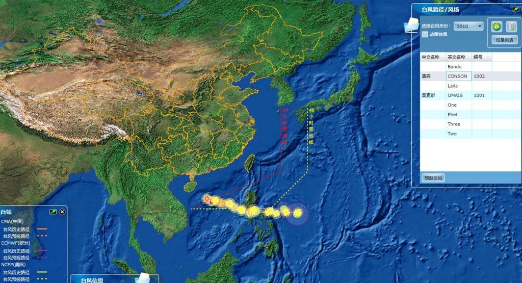


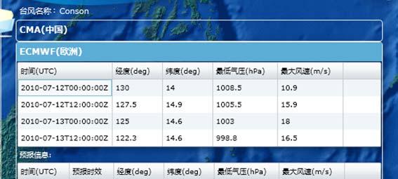

14 3. System Implementation Flexible Track Query: Historical, current and forecasting
15 3. System Implementation From TC track to wind swath : GIS Algorithm (1) Harbin 1985/8/20 0:00Z 40 Changchun Huhohot Shenyang1985/8/19 18:00Z Xining Lanzhou Yinchuan Beijing Tianjin Taiyuan Shijiazhuang 1985/8/19 12:00Z Jinan 1985/8/19 6:00Z 35 Xi'an Zhengzhou 1985/8/19 0:00Z 1985/8/18 18:00Z Chengdu Chongqing Guiyang Nanning Wuhan Changsha Nanchang Hongkong Macau Guangzhou Hefei Nanjing Shanghai 1985/8/18 0:00Z Hangzhou 1985/8/18 12:00Z 1985/8/18 6:00Z 1985/8/17 18:00Z 1985/8/17 12:00Z 1985/8/17 6:00Z 1985/8/17 0:00Z 1985/8/16 18:00Z 1985/8/16 12:00Z 1985/8/16 6:00Z Fuzhou 1985/8/16 0:00Z 1985/8/15 18:00Z Taipei 1985/8/15 0:00Z Taibei1985/8/14 18:00Z 1985/8/15 6:00Z 1985/8/14 12:00Z 1985/8/14 6:00Z Intensity category Weaker than Tropical Depression Tropical Depression (TD, m/s) Tropical Storm (TS, m/s) Severe Tropical Storm (STS, m/s) Typhoon (TY, m/s) 5-Severe Typhoon (STY, m/s) 6-Super Typhoon (SuperTY, 51.0 m/s) 9-Extratropical Transition Cyclone (ET) Wind Swath Beaufort Scale 6 Beaufort Scale 8 Beaufort Scale 10 Real Wind Range Haikou Beaufort Scale 6 Beaufort Scale 8 Beaufort Scale (Mimie)
")
16 3. System Implementation From TC track to wind swath : GIS Algorithm (2) 0505(Haitang)

")
17 3. System Implementation Satellite Rainfall Monitoring: TRMM (3h) and FY2, and FY3 (1h)


18 3. System Implementation Rapid Loss Assessment: map, graph, PDF output
19 4. Future Study Loss Assessment Inland flood Storm surge Uncertainty Analysis Emergency Response Resources Allocation Optimization
20 Thank you for your attention
Sampling Scheme for 2003 General Social Survey of China
 Sampling Scheme for 2003 General Social Survey of China 1. Sampling Unit This survey uses a five-stage stratified sampling scheme with unequal probabilities. The sampling units at each stage are as follows:
Activities and Outlook related to Disaster Reduction in CMA
 Activities and Outlook related to Disaster Reduction in CMA WANG Bangzhong China Meteorological Administration March 15-17 2006 ADENDA Situation about MD and related disasters in CHINA Guidance for MD/RD
a. State Key Laboratory of Hydrology-Water Resources and Hydraulic Engineering, Hohai
 Sulementary Information Periodic fluctuation of reference evaotransiration during the ast five decades: Does Evaoration Paradox really exist in China? Wanqiu Xing a,b, Weiguang Wang a, b *, Quanxi Shao
DEVELOPMENT OF CHINESE WEATHER DATA FOR BUILDING ENERGY CALCULATIONS
 DEVELOPMENT OF CHINESE WEATHER DATA FOR BUILDING ENERGY CALCULATIONS ABSTRACT Zhang Qingyuan Tsukuba College of Technology Tsukuba Japan Joe Huang Lawrence Berkeley National Laboratory Berkeley CA USA
Climatology and Trends of High Temperature Extremes across China in Summer
 ATMOSPHERIC AND OCEANIC SCIENCE LETTERS, 2009, VOL. 2, NO. 3, 153 158 Climatology and Trends of High Temperature Extremes across China in Summer WEI Ke and CHEN Wen Center for Monsoon System Research,
Pacific Catastrophe Risk Assessment And Financing Initiative
 Pacific Catastrophe Risk Assessment And Financing Initiative PALAU September is expected to incur, on average,.7 million USD per year in losses due to earthquakes and tropical cyclones. In the next 5 years,
Spatial Changes of Chinese Cities Under the Condition of Exo-Urbanization
 Spatial Changes of Chinese Cities Under the Condition of Exo-Urbanization Yanguang Chen Department of Geography, Peking University, Beijing 0087, PRC. Email: chenyg@pku.edu.cn. Abstract: Only a preliminary
Pacific Catastrophe Risk Assessment And Financing Initiative
 Pacific Catastrophe Risk Assessment And Financing Initiative VANUATU September 211 Country Risk Profile: VANUATU is expected to incur, on average, 48 million USD per year in losses due to earthquakes and
Instrumental Temperature Series in Eastern and Central China Back to the 19th Century
 Instrumental Temperature Series in Eastern and Central China Back to the 19th Century Lijuan Cao, Ping Zhao, Zhongwei Yan, Phil Jones et al. National Meteorological Information center, CMA Budapest 2014.05.13
THE STUDY OF NUMBERS AND INTENSITY OF TROPICAL CYCLONE MOVING TOWARD THE UPPER PART OF THAILAND
 THE STUDY OF NUMBERS AND INTENSITY OF TROPICAL CYCLONE MOVING TOWARD THE UPPER PART OF THAILAND Aphantree Yuttaphan 1, Sombat Chuenchooklin 2 and Somchai Baimoung 3 ABSTRACT The upper part of Thailand
CURRENT AND FUTURE TROPICAL CYCLONE RISK IN THE SOUTH PACIFIC
 CURRENT AND FUTURE TROPICAL CYCLONE RISK IN THE SOUTH PACIFIC COUNTRY RISK PROFILE: SAMOA JUNE 2013 Samoa has been affected by devastating cyclones on multiple occasions, e.g. tropical cyclones Ofa and
Briefing on the WMO Support to Viet Nam to cope with Typhoon Haiyan
 WMO Briefing on the WMO Support to Viet Nam to cope with Typhoon Haiyan A Case of WMO Emergency Response Typhoon Haiyan trajectory Background Typhoon Haiyan remained strong after devastating the Philippines
Pacific Catastrophe Risk Assessment And Financing Initiative
 Pacific Catastrophe Risk Assessment And Financing Initiative TUVALU is expected to incur, on average,. million USD per year in losses due to earthquakes and tropical cyclones. In the next 5 years, has
Miami-Dade County Overview
 Miami-Dade County Overview 2,000 square miles World s busiest cruise port 2.6 million residents Second busiest US airport for international travelers Gateway to the Caribbean and Latin America Natural
Initiative. Country Risk Profile: papua new guinea. Better Risk Information for Smarter Investments PAPUA NEW GUINEA.
 Pacific Catastrophe Risk Assessment And Financing Initiative PAPUA NEW GUINEA September 211 Country Risk Profile: papua new is expected to incur, on average, 85 million USD per year in losses due to earthquakes
B.2 Sources for Hazard Identification, Profiling, and Ranking (Section 3) Overview of Sussex County s History of Hazards
 Overview of Sussex County s History of Hazards") Appendix B Sources B.1 Sources for Planning Process (Section 2) FEMA. Mitigation Planning Guidance (386 Series). Available on the web at: http://www.fema.gov/plan/mitplanning/planning_resources.shtm FEMA
Appendix B Sources B.1 Sources for Planning Process (Section 2) FEMA. Mitigation Planning Guidance (386 Series). Available on the web at: http://www.fema.gov/plan/mitplanning/planning_resources.shtm FEMA
Hurricane Readiness for Coastal Communities
 Hurricane Readiness for Participant Guide Developed for: Federal Emergency Management Agency Emergency Management Institute 16825 South Seton Avenue Emmitsburg, MD 21727-8998 Developed by: C² Technologies,
CURRENT AND FUTURE TROPICAL CYCLONE RISK IN THE SOUTH PACIFIC
 CURRENT AND FUTURE TROPICAL CYCLONE RISK IN THE SOUTH PACIFIC SOUTH PACIFIC JUNE 2013 The South Pacific region is prone to significant tropical cyclone risk. This project compared both current and future
Canes on Canes: Keeping South Florida Prepared During the Calm Before the Storm. Matt Onderlinde and Pete Finocchio
 Canes on Canes: Keeping South Florida Prepared During the Calm Before the Storm Matt Onderlinde and Pete Finocchio Outline The Science of Hurricanes Why and When South Floridians Must Be Weather-Ready
Emerging Needs, Challenges and Response Strategy
 Emerging Needs, Challenges and Response Strategy Development of Integrated Observing Systems in China JIAO Meiyan Deputy Administrator China Meteorological Administration September 2011 Geneva Outline
New Weather Indices for China: Tool of Risk Control of International Supply Chain
 Association for Information Systems AIS Electronic Library (AISeL) WHICEB 2018 Proceedings Wuhan International Conference on e-business Summer 6-30-2018 New Weather Indices for China: Tool of Risk Control
Progress of Space Technology Application for Disaster Management in China
 Progress of Space Technology Application for Disaster Management in China LI Qun Department of Disaster Relief Ministry of Civil Affairs of P.R.China Background drought 1 2 flood earthquake typhoon Progress
IDENTIFICATION OF HAZARDS OF CONCERN
 IDENTIFICATION OF HAZARDS OF CONCERN To provide a strong foundation for mitigation strategies considered in Section 6, the Village considered a full range of hazards that could impact the area and then
Application of Satellite analysis in tropical cyclone of CMA
 2 nd International Workshop On Satellite Analysis of Tropical Cyclones (IWSATC-2) Satellite TC Analysis in Operations: Changes since IWSATC-1 17 February 2016 Honolulu, Hawaii, USA Application of Satellite
Pacific Catastrophe Risk Assessment And Financing Initiative
 Pacific Catastrophe Risk Assessment And Financing Initiative TIMOR-LESTE September Timor-Leste is expected to incur, on average, 5.9 million USD per year in losses due to earthquakes and tropical cyclones.
Hazardous Weather and Flooding Preparedness. Hazardous Weather and Flooding Preparedness
 Hazardous Weather and Flooding Preparedness 1 A Cooperative Effort 2 Administrative Information Emergency exits and procedures Location of restrooms Mobile devices Procedure for questions Course materials
Workshop on Drought and Extreme Temperatures: Preparedness and Management for Sustainable Agriculture, Forestry and Fishery
 Workshop on Drought and Extreme Temperatures: Preparedness and Management for Sustainable Agriculture, Forestry and Fishery 16-17 Feb.2009, Beijing, China Modeling Apple Tree Bud burst time and frost risk
Land Use Change Patterns and Sustainable Urban Development in China
 Land Use Change Patterns and Sustainable Urban Development in China Haiyan Zhang* 1, Michinori Uwasu 2, Keishiro Hara 3 and Helmut Yabar 2 1 Research Fellow, Research Institute for Sustainability Science,
THE INTEGRATED INFORMATION SYSTEM FOR NATURAL
 THE INTEGRATED INFORMATION SYSTEM FOR NATURAL DISASTER MITIGATION Junxiu Wu 1, Qiang Feng 2*, Bijun Liang 3, and Angsheng Wang 4 1 Department of Computer System, Technological Bureau of Xinhua News Agency,
Hurricane Basics and Preparedness. Jim Weyman Director, Central Pacific Hurricane Center Phone Office:
 Hurricane Basics and Preparedness Jim Weyman Director, Central Pacific Hurricane Center Phone Office: 973-5270 james.weyman@noaa.gov United States Hurricane/Typhoon Centers National Hurricane Center, Miami
Comparative Analysis of Hurricane Vulnerability in New Orleans and Baton Rouge. Dr. Marc Levitan LSU Hurricane Center. April 2003
 Comparative Analysis of Hurricane Vulnerability in New Orleans and Baton Rouge Dr. Marc Levitan LSU Hurricane Center April 2003 In order to compare hurricane vulnerability of facilities located in different
DAGUPAN CITY EXPERIENCES, GOOD PRACTICES, CHALLENGES AND LESSONS LEARNED ON DISASTER RISK MANAGEMENT
 DAGUPAN CITY EXPERIENCES, GOOD PRACTICES, CHALLENGES AND LESSONS LEARNED ON DISASTER RISK MANAGEMENT Reducing Vulnerability to Climate Change Impacts and Related Natural Disasters in East Asia 12 and 13
Development Project High Resolution Numerical Prediction of Landfalling Typhoon Rainfall (tentative title)
") A Proposal for the WMO/WWRP Research and Development Project High Resolution Numerical Prediction of Landfalling Typhoon Rainfall (tentative title) Yihong Duan WGTMR Proposed in the side meeting of the
A Proposal for the WMO/WWRP Research and Development Project High Resolution Numerical Prediction of Landfalling Typhoon Rainfall (tentative title) Yihong Duan WGTMR Proposed in the side meeting of the
Understanding Weather and Climate Risk. Matthew Perry Sharing an Uncertain World Conference The Geological Society, 13 July 2017
 Understanding Weather and Climate Risk Matthew Perry Sharing an Uncertain World Conference The Geological Society, 13 July 2017 What is risk in a weather and climate context? Hazard: something with the
Summary of the Presentation
 CBMS & GIS Utilization in Planning for Disaster Risk Reduction & Management (DRRM) and Climate Change Adaptation (CCA) Presented by: ENGR. MARIVIC J. NIERRAS, EnP Planning Officer IV and Officer-In-Charge
COUNTRY PRESENTATION ON MR JAYNAL ABEDIN JOINT SECRETARY ( WORKS & DEVELOPMENT ) MINISTRY OF DEFENCE
 MINISTRY OF DEFENCE") COUNTRY PRESENTATION ON By MR JAYNAL ABEDIN JOINT SECRETARY ( WORKS & DEVELOPMENT ) MINISTRY OF DEFENCE Bangladesh Geographical Location of Bangladesh Bangladesh Country at a Glance Physical Features 1,230
COUNTRY PRESENTATION ON By MR JAYNAL ABEDIN JOINT SECRETARY ( WORKS & DEVELOPMENT ) MINISTRY OF DEFENCE Bangladesh Geographical Location of Bangladesh Bangladesh Country at a Glance Physical Features 1,230
2017 Hurricane Season and Beyond
 2017 Hurricane Season and Beyond Ken Graham National Hurricane Center Building a Weather-Ready Nation Much of U.S. Coast Saw Tropical Wind Watches or Warnings 2017 Hurricane Season Facts and Figures 7th
Geospatial application in Kiribati
 Geospatial application in Kiribati ICC-21 ST RESAP (9 TH TO 13 TH OCTOBER, 2017) BANGKOK, THAILAND Outline Kiribati Profile Natural disasters in Kiribati Achievements Challenges/Issues Ways forward 1 Kiribati
MODELLING CATASTROPHIC COASTAL FLOOD RISKS AROUND THE WORLD
 MODELLING CATASTROPHIC COASTAL FLOOD RISKS AROUND THE WORLD Nicola Howe Christopher Thomas Copyright 2016 Risk Management Solutions, Inc. All Rights Reserved. June 27, 2016 1 OUTLINE MOTIVATION What we
Impact assessment on disasters
 The 5th International Coordination Group (ICG) Meeting GEOSS Asian Water Cycle Initiative (AWCI), Dec. 16, 2009. Impact assessment on disasters Eiichi Nakakita Disaster Prevention Research Institute Kyoto
The Philippines modified its Tropical Cyclone Warning System
 The Philippines modified its Tropical Cyclone Warning System Historical Background As an archipelago in Western North Pacific, the Philippines is exposed to tropical cyclones of varying intensity and impacts
JMA/WMO WORKSHOP ON EFFECTIVE TROPICAL CYCLONE WARNING IN SOUTHEAST ASIA
 JMA/WMO WORKSHOP ON EFFECTIVE TROPICAL CYCLONE WARNING IN SOUTHEAST ASIA TROPICAL CYCLONE MONITORING IN LAO PDR TOKYO, JAPAN 11 14 March 2014 Ministry of Natural Resource and Environment (MONRE) Department
MarcoPolo. Monitoring and Assessment of Regional air quality in China using space Observations. Project Of Long-term sino-european co-operation
 Project no. 606953 MarcoPolo Monitoring and Assessment of Regional air quality in using space Observations. Project Of Long-term sino-european co-operation Type of funding scheme: Collaborative Project
2014 Summer training course for slope land disaster reduction Taipei, Taiwan, Aug
 MINISTRY OF SCIENCE AND TECHNOLOGY HYDROTECH RESEARCH INSTITUTE MINISTRY OF NATURAL RESOURCES AND ENVIRONMENT VIETNAM INSTITUTE OF GEOSCIENCES AND MINERAL RESOURCES (VIGMR) 2014 Summer training course
LIGHTNING DISTRIBUTION AND EYEWALL OUTBREAKS IN TROPICAL CYCLONES DURING LANDFALL
 LIGHTNING DISTRIBUTION AND EYEWALL OUTBREAKS IN TROPICAL CYCLONES DURING LANDFALL Wenjuan Zhang* 1, Yijun Zhang 1,2, Dong Zheng 1, Xiuji Zhou 1,2 1 Laboratory of Lightning Physics and Protection Engineering,
TROPICAL DEPRESSION HARVEY BRIEFING
 TROPICAL DEPRESSION HARVEY BRIEFING 10:15 PM CDT Wednesday, August 23, 2017 Prepared by: Lara Beal NWSCorpus www.weather.gov/corpuschristi Situation Overview No changes to Watches. Hurricane Watch remains
Integrating Climate Adaptation in Hawaii Disaster Risk Management
 Integrating Climate Adaptation in Hawaii Disaster Risk Management Building Resilient Communities HCPO/HIGICC 2009 Conference September 23-25 Sheraton Waikiki Introduction What are weather/climate-related
Copernicus Overview. Major Emergency Management Conference Athlone 2017
 Copernicus Overview Major Emergency Management Conference Athlone 2017 Copernicus is a European programme implemented by the European Commission. The services address six thematic areas: land, marine,
A STATISTICAL MODEL FOR PREDICTION OF INTENSITY AND FREQUENCY OF TROPICAL CYCLONES MAKING LANDFALL ON CHINA
 Vol.18 No.1 JOURNAL OF TROPICAL METEOROLOGY March 2012 Article ID: 1006-8775(2012) 01-0108-05 A STATISTICAL MODEL FOR PREDICTION OF INTENSITY AND FREQUENCY OF TROPICAL CYCLONES MAKING LANDFALL ON CHINA
Routing Hazmat Multimodal Transportation Based on CVaR Assessment
 207 Asia-Pacific Engineering and Technology Conference (APETC 207) ISBN: 978--60595-443- outing azmat Multimodal Transportation Based on CVa Assessment Liping Liu, ongxue Du, Shuxia Li, Tun Fan and Yifan
National Report on Weather Forecasting Service
 MINISTRY OF WATER RESOURCES AND METEOROLOGY DEPARTMENT OF METEOROLOGY, CAMBODIA National Report on Weather Forecasting Service Tokyo, 11-15 March 2014 Department of Meteorology, Cambodia Presentation Outline
Use of Geospatial data for disaster managements
 Use of Geospatial data for disaster managements Source: http://alertsystemsgroup.com Instructor : Professor Dr. Yuji Murayama Teaching Assistant : Manjula Ranagalage What is GIS? A powerful set of tools
Characteristic analysis of typhoon disaster chains in the Yangtze River Delta region of China
 DOI:10.13577/j.jnd.2012.0306 21 3 2012 6 JOURNAL OF NATURAL DISASTERS Vol. 21 No. 3 Jun. 2012 1004-4574 2012 03-0036 - 07 1 2 1 2 3 1 2 3 1. 100875 2. 100875 3. - 100875 1951-2008 58 187 3 DEM 3 3 - -
Tropical Storm Harvey: SE Texas Impacts
 Tropical Storm Harvey: SE Texas Impacts 10 AM CDT UPDATE Thursday, August 24, 2017 Prepared by: Dan Reilly, Brian Kyle PLEASE MUTE YOUR LINES AND DON T PUT ON HOLD! Situation Overview Tropical Storm Harvey
Landslide Hazard Assessment Methodologies in Romania
 A Scientific Network for Earthquake, Landslide and Flood Hazard Prevention SciNet NatHazPrev Landslide Hazard Assessment Methodologies in Romania In the literature the terms of susceptibility and landslide
Coastal Emergency Risks Assessment - CERA Real-Time Storm Surge and Wave Visualization Tool
 Coastal Emergency Risks Assessment - CERA Real-Time Storm Surge and Wave Visualization Tool Introduction This document provides guidance for using the Coastal Emergency Risks Assessment (CERA) visualization
Daily Operations Briefing Wednesday, July 6, :30 a.m. EDT
 Daily Operations Briefing Wednesday, July 6, 2016 8:30 a.m. EDT Significant Activity: July 5-6 Significant Events: Severe Weather Plains to Ohio Valley Tropical Activity: Atlantic Tropical cyclone activity
Daily Operations Briefing Friday, May 8, :30 a.m. EDT
 Daily Operations Briefing Friday, May 8, 2015 8:30 a.m. EDT Significant Activity: May 7-8 Significant Events: Severe weather Central/Southern Plains Tropical Activity: Atlantic: Subtropical Storm Ana Western
Draft for Discussion 11/11/2016
 Coastal Risk Consulting (CRC) Climate Vulnerability Assessment for Village of Key Biscayne Deliverable 1.1 in Statement of Work. Preliminary Vulnerability Assessment Identifying Flood Hotspots Introduction...
Table-Top Exercise for Emergency Preparedness Evaluation: Little Anse, Isle Madame
 Table-Top Exercise for Emergency Preparedness Evaluation: Little Anse, Isle Madame Alexander Chung, M.Sc. Candidate C-Change Student Research Associate May 2013 The Community of Little Anse Coastal community
Rainfall-Flood Hazard along the Cagayan River in Carmen
 -Flood Hazard along the Cagayan River in Carmen Things to watch out for when rain falls intensity 12 December 2013, Cagayan de Oro City Hall 3 +1 main questions I What do we need to understand about rainfall
An overview of the applications for early warning and mapping of the flood events in New Brunswick
 Flood Recovery, Innovation and Reponse IV 239 An overview of the applications for early warning and mapping of the flood events in New Brunswick D. Mioc 1, E. McGillivray 2, F. Anton 1, M. Mezouaghi 2,
Daily Operations Briefing. Tuesday, July 4, :30 a.m. EDT
 Daily Operations Briefing Tuesday, July 4, 2017 8:30 a.m. EDT Significant Activity July 3-4 Significant Events: None Tropical Activity: Atlantic Disturbance 1: High (80%) Eastern Pacific Disturbance 1:
Assumption Parish Hazard Mitigation Plan Update Public Meeting. September 1, 2015 Napoleonville, LA
 Assumption Parish Hazard Mitigation Plan Update Public Meeting September 1, 2015 Napoleonville, LA Agenda Hazard Mitigation Planning Process SDMI Staff Risk Assessment SDMI Staff Update on Previous/Current
Recent studies on tropical cyclone landfalling in China
 Recent studies on tropical cyclone landfalling in China Lei Xiaotu Shanghai Typhoon Institute CMA, Shanghai, China email: xtlei@21cn.com 1. Losses caused by tropical cyclones in China China is one of the
They include earthquakes, volcanic eruptions, floods, landslides, and other processes and occurrences. They are included in the broader concept of.
 They include earthquakes, volcanic eruptions, floods, landslides, and other processes and occurrences. They are included in the broader concept of. In general, natural processes are labeled hazardous only
An Application of Hydrometeorological Information
 An Application of Hydrometeorological Information Weather-proof Café: Hydro-meteorological information in managing weather risks 17 19 November 2012 National Taiwan University, Chinese Taipei Nikos Viktor
Enquiry question: How does the world s climate system function, why does it change and how can this be hazardous for people?
 Content Topic 1: Hazardous Earth Enquiry question: How does the world s climate system function, why does it change and how can this be hazardous for people? 1.1 The atmosphere operates as a global system
Status and Data Applications of China Highresolution Earth Observation System. Earth Observation System and Data Center, CNSA Sep, 2016
 Status and Data Applications of China Highresolution Earth Observation System Earth Observation System and Data Center, CNSA Sep, 2016 Outlines Introduction Development of the Space-based System CHEOS
Outline of Guideline for Development and Utilization of Tsunami Disaster Management Map
 Outline of Guideline for Development and Utilization of Tsunami Disaster Management Map Port and Airport Research Institute, Japan The Overseas Coastal Area Development Institute of Japan Ports and Harbours
5.2. IDENTIFICATION OF NATURAL HAZARDS OF CONCERN
 5.2. IDENTIFICATION OF NATURAL HAZARDS OF CONCERN To provide a strong foundation for mitigation strategies considered in Sections 6 and 9, County considered a full range of natural hazards that could impact
Sentinel Asia Data Provider Node Report
 Sentinel Asia Data Provider Node Report Joint Project Team Meeting for Sentinel Asia STEP3 (JPTM2018) 23 24 January 2018, Taipei, Taiwan Yuji TAKADA Space Applications and Operations Center (SAOC) Japan
PAGASA s Expectations of New-generation Satellites for Hazard Monitoring
 Country Report Philippines PAGASA s Expectations of New-generation Satellites for Hazard Monitoring VICENTE P. PALCON, JR. (Assistant Weather Services Chief) Weather Division- PAGASA DOST Email: vppalconjr@pagasa.dost.gov.ph
International Symposium on Natural Disaster Mitigation. Local vulnerability assessment of landslides and debris flows
 International Symposium on Natural Disaster Mitigation of landslides and debris flows Lessons learnt from Cam Pha town and Van Don district, Quang Ninh province, Vietnam Nguyen Quoc Phi Faculty of Environment
The National Hurricane Center
 The National Hurricane Center Where we are and where we hope to go Bill Read, Director National Hurricane Center U.S. HURRICANE FORECAST SERVICE HISTORY MODERN ERA HIGHLIGHTS 1935: Began 24 hour forecast
Daily Operations Briefing Wednesday, June 10, :30 a.m. EDT
 Daily Operations Briefing Wednesday, June 10, 2015 8:30 a.m. EDT Significant Activity: June 9-10 Significant Events: None Tropical Activity: Atlantic Tropical cyclone activity not expected next 48 hours
Joint Meeting of RA II WIGOS Project and RA V TT-SU on 11 October 2018 BMKG Headquarter Jakarta, Indonesia. Mrs. Sinthaly CHANTHANA
 Joint Meeting of RA II WIGOS Project and RA V TT-SU on 11 October 2018 BMKG Headquarter Jakarta, Indonesia Mrs. Sinthaly CHANTHANA Lao PDR Background Department of Meteorology and Hydrology ( DMH ) in
5.2 IDENTIFICATION OF HAZARDS OF CONCERN
 5.2 IDENTIFICATION OF HAZARDS OF CONCERN 2015 HMP Update Changes The 2010 HMP hazard identification was presented in Section 6. For the 2015 HMP update, the hazard identification is presented in subsection
Global Atmospheric Circulation. Past climate change and natural causes. Global climate change and human activity
 GCSE Geography Edexcel B Revision Checklist Paper 1. Global Geographical Issues Topic 1. Hazardous Earth Key Idea I know/ understand The world s climate system Global Atmospheric Circulation Past climate
World Urban Database and Access Portal Tools (WUDAPT) Mapping Global Cities by Using a Common Language
 Mapping Global Cities by Using a Common Language") World Urban Database and Access Portal Tools (WUDAPT) Mapping Global Cities by Using a Common Language Prof. Chao REN*,The Chinese University of Hong Kong, Hong Kong Prof. Gerald MILLS, University College
World Urban Database and Access Portal Tools (WUDAPT) Mapping Global Cities by Using a Common Language Prof. Chao REN*,The Chinese University of Hong Kong, Hong Kong Prof. Gerald MILLS, University College
STEUBEN COUNTY, NEW YORK. Hazard Analysis Report
 STEUBEN COUNTY, NEW YORK Hazard Analysis Report Prepared by: April 1, 2014 Background On April 1, 2014 the Steuben County Office of Emergency Management conducted a hazard analysis using the automated
USING 3D GIS TO ASSESS ENVIRONMENTAL FLOOD HAZARDS IN MINA
 King Fahd University of Petroleum & Minerals College of Environmental Design Geographical Information system USING 3D GIS TO ASSESS ENVIRONMENTAL FLOOD HAZARDS IN MINA Prepared by : Ali AL-Zahrani OUTLINE
Proposal Report On Flood Hazards Mapping Project In Xebangfai River
 Proposal Report On Flood Hazards Mapping Project In Xebangfai River Prepared By Mr. Boualaythong KOUMPHONH Climate Division Department of Meteorology and Hydrology Water Resources and Environment Administration
DEVELOPMENT OF ARCGIS-CUSTOMIZED TOOL FOR FLOOD RISK ASSESSMENT AND REPORT GENERATION IN BUTUAN CITY
 DEVELOPMENT OF ARCGIS-CUSTOMIZED TOOL FOR FLOOD RISK ASSESSMENT AND REPORT GENERATION IN BUTUAN CITY Alexander T. Demetillo, Michelle V. Japitana, Dennis Y. Villanueva and Cherry Mae P. Tulfo CLAIMS-GIS
Massachusetts Hurricane Evacuation Study
 Massachusetts Hurricane Evacuation Study Technical Data Report May 2016 New England District Massachusetts Hurricane Evacuation Study Technical Data Report May 2016 Table of Contents 1.0 Study Area...
Daily Operations Briefing Sunday, January 8, :30 a.m. EST
 Daily Operations Briefing Sunday, January 8, 2017 8:30 a.m. EST Significant Activity Jan 6-8 Significant Events: Heavy Precipitation forecast to impact CA and NV Significant Weather: Freezing rain Pacific
Daily Operations Briefing. Sunday, October 19, :30 a.m. EDT
 Daily Operations Briefing Sunday, October 19, 2014 8:30 a.m. EDT Significant Activity: Oct 18-19 Significant Events: Hurricane Ana Tropical Activity: Atlantic Hurricane Gonzalo (FINAL) Eastern Pacific
PACIFIC CATASTROPHE RISK ASSESSMENT AND FINANCING INITIATIVE
 PACIFIC CATASTROPHE RISK ASSESSMENT AND FINANCING INITIATIVE PW FM MH NR KI TL PG SB VU TV WS FJ CK NU TO SEPTEMBER 11 The Pacific Region is prone to many natural hazards that threaten populations and
MEMBER REPORT THAILAND. ESCAP/WMO Typhoon Committee. 9 Integrated Workshop. Bangkok, Thailand
 MEMBER REPORT ESCAP/WMO Typhoon Committee th 9 Integrated Workshop THAILAND Bangkok, Thailand 20-24 October 2014 CONTENTS CONTENTS Page I. Overview of tropical cyclones which have affected/impacted Member
SECTION II Hydrological risk
 Chapter 3 Understanding disaster risk: hazard related risk issues SECTION II Hydrological risk Peter Salamon Coordinating lead author Hannah Cloke Lead author 3.4 Giuliano di Baldassarre Owen Landeg Florian
The Experiment on Typhoon Intensity Change in Coastal Area (EXOTICCA) ANNUAL REPORT (Item of Tentative Program for 49 th TC Session)
 ANNUAL REPORT (Item of Tentative Program for 49 th TC Session)") ESCAP/WMO Typhoon Committee 49 th Session 21-24 February 2017 Yokohama, Japan FOR PARTICIPANTS ONLY WRD/TC.49/5.4.1 31 December 2016 ENGLISH ONLY The Experiment on Typhoon Intensity Change in Coastal Area
ESCAP/WMO Typhoon Committee 49 th Session 21-24 February 2017 Yokohama, Japan FOR PARTICIPANTS ONLY WRD/TC.49/5.4.1 31 December 2016 ENGLISH ONLY The Experiment on Typhoon Intensity Change in Coastal Area
Complete Weather Intelligence for Public Safety from DTN
 Complete Weather Intelligence for Public Safety from DTN September 2017 White Paper www.dtn.com / 1.800.610.0777 From flooding to tornados to severe winter storms, the threats to public safety from weather-related
Daily Operations Briefing. Thursday, July 6, :30 a.m. EDT
 Daily Operations Briefing Thursday, July 6, 2017 8:30 a.m. EDT Significant Activity July 5-6 Significant Events: None Tropical Activity: Atlantic Tropical Depression Four Eastern Pacific Disturbance 1:
To Construct the Theory and Practice System of Integrated Disaster Risk Management
 WCDR, 18-22 January 2005, Kobe, Japan To Construct the Theory and Practice System of Integrated Disaster Risk Management Peijun Shi 1, Norio Okada 2 1.IDPS, Beijing Normal University, China 2. DPRI, Kyoto
Tracking Storm Tide and Coastal Flooding During Hurricane Matthew
 Tracking Storm Tide and Coastal Flooding During Hurricane Matthew Stephen Harden, Jeanne Robbins, and Eric Frantz U.S. Geological Survey, South Atlantic Water Science Center Presented to: WRRI Annual Conference
Smart use of Geographic Information System (GIS) platform for delivering weather information and nowcasting services
 platform for delivering weather information and nowcasting services") Smart use of Geographic Information System (GIS) platform for delivering weather information and nowcasting services C. K. Pan Hong Kong Observatory Hong Kong, China It is a world of beauty Source: Image
Smart use of Geographic Information System (GIS) platform for delivering weather information and nowcasting services C. K. Pan Hong Kong Observatory Hong Kong, China It is a world of beauty Source: Image
ÖBB Natural Hazard Management
 ÖBB Natural Hazard Management Management of Weather Events in the Austrian Federal Railways MOWE-IT, Brussels 17 th of September 2013 DI Günther Kundela Integrated Track Management Integration Technic
NWS HURRICANES June 3, 2015
 NWS HURRICANES June 3, 2015 Hurricane Season June 1 November 30 2 What s the concern? All tropical systems passing within 125nm of central Maryland since 1950 Mid-Atlantic Hurricanes Greatest Risk: August
The WMO Tropical Cyclone Programme(TCP)
") The WMO Tropical Cyclone Programme(TCP) Session 4: Insights into some WMO ProgrammeActivities to Support MHEWS at National, Regional and Global Levels UI-EAG MHEWS, 19-21 April 2016, Geneva Anne-Claire
The WMO Tropical Cyclone Programme(TCP) Session 4: Insights into some WMO ProgrammeActivities to Support MHEWS at National, Regional and Global Levels UI-EAG MHEWS, 19-21 April 2016, Geneva Anne-Claire
Status and Challenges on Geo-DRM Information Systems in Tonga
 Name: Mafua- i-vai utukakau Maka Status and Challenges on Geo-DRM Information Systems in Tonga 1 Roles and Relationships Land and Geographic Information Systems (LGIS) Unit: Establish updated high-resolution