RESPONDING TO A RISING TIDE
|
|
|
- Matilda Gray
- 5 years ago
- Views:
Transcription


1 RESPONDING TO A RISING TIDE Coastal Storm Hazards for Cape Cod Bob Thompson National Weather Service Taunton, MA
2 COASTAL STORMS Types of coastal storms Tropical Cyclones (e.g. hurricanes) Hurricane Bob August 19, 1991 Extratropical Cyclones (e.g. nor easters) Perfect Storm October 30, 1991 Impacts from Hurricanes and Nor easters National Weather Service Resources Concluding Thoughts
3 NEW ENGLAND HURRICANES Low Frequency, High Impact! Category 3 hurricanes Great Colonial Hurricane of 1635 Hurricane of 1815 Hurricane of 1869 Great New England hurricane of 1938 Carol in 1954 Strong Category 2 hurricane Great Atlantic Hurricane of 1944 Edna in 1954 Last land-falling hurricane Bob in August 1991
4 A Preparedness Challenge No Category 3 hurricanes have made landfall in southern New England since 1954 And no hurricane at all since 1991 Buildup in coastal population and infrastructure presents a high risk for life and property Most New Englanders have not experienced a worst case scenario and many no hurricane at all! Inexperienced population!

5 Category 5 Winds > 155 mph Category 4 Winds mph Category 3 Winds mph Category 2 Winds mph Category 1 Winds mph Destructive potential of wind increases by the square of the wind speed! Storm surge not closely correlated with hurricane category Saffir-Simpson Simpson Scale
6 Hurricanes Come in Different Flavors 1938 or Carol Type Hurricanes Most dangerous Fast and furious Sandy Type Hybrid May have tropical core but behaves like very severe nor easter A Brusher - Earl or Edouard Type Hurricane Brushes by coast May be too close for comfort Primary impacts may be rip currents and erosion
7 Jet Stream Interaction

8 Tropical Cyclones Impacting New England Point at which New Englanders need to take action!

9 Key on approach of first tropical storm force squalls not the eye!

10 Hurricane Impacts Wind Flooding Rains Coastal Flooding from Storm Surge and Waves

11 History can be a Guide to Our Future! Wind 1938 Hurricane damage in Keene, NH Gusts to 60 mph during Bob 1938 Hurricane took down over a billion trees in New England - 91 million in just Windham County in northeast Connecticut


 in")
12 History can be a Guide to Our Future! Flooding Rain 1938 Hurricane Flooding in Winchendon Tropical Storm Diane in 1955 Flash Flooding on route 44 in Putnam, CT Tropical Storm Irene Flash Flooding along the Deerfield River (and Conway Street) in Buckland Photo: J. Brown


13 History can be a Guide to Our Future! Flooding from Storm Surge 1938 Hurricane 13 foot surge Hurricane Bob (1991) 6 foot surge Near worst case for Narragansett and Buzzards Bays

14 Storm Surge for Category 3 Hurricane moving NNE at 50 mph

15 Storm Surge At Low Tide Timing of Storm Critical!
16 Storm Surge At High Tide Timing of Storm Critical!


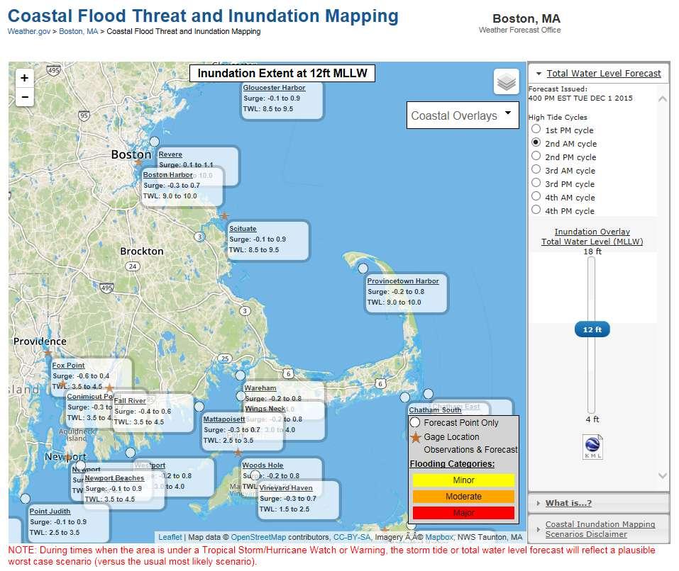
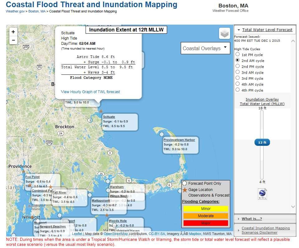
17 New Developments from National Hurricane Center Storm Surge Warnings Explicit Storm Surge Warning versus implicit by a Hurricane Warning Recommended by social scientists Inundation mapping Visualization of inundation possible from a specific storm Represents plausible worst case scenario (10% exceedance) Depicts where risk too high not to take action Does not incorporate wave runup/overwash Currently only for tropical cyclones

18 Why is forecasting hard?
19 Hurricane Joaquin 115 PM EDT Wednesday September 30, 2015

20 Why is forecasting hard? Hurricane Joaquin Wed Sept. 30 AM models Wed Sept. 30 PM models

21 Joaquin Forecasts from Two Main Stream Global Models 90 hour forecast from GFS Model ECMWF Model

22 Major Hurricane Joaquin: Category 4 (130 mph sustained)

23 UPPER LEVEL TROUGH UPPER LEVEL TROUGH JOAQUIN
24 Powerful Hurricane Joaquin: Category 3 (125 mph sustained)


25 NHC Atlantic Track Error Trends Error Reduction since 1990: 72 h: 67% 48 h: 65% 24 h: 58%

26 Sometimes, the clouds will telegraph their Intentions
27 NOR EASTER IMPACTS January 27, 2015 morning Scituate, MA courtesy Dave Laroche

28 Anatomy of a Major Nor easter Upper level wind energy Sharp lower level temperature gradient From Kocin and Uccellini, 2004
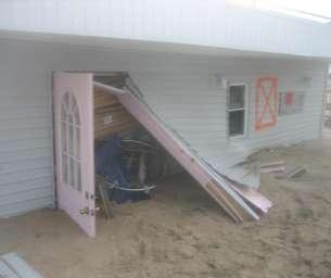
29 The Basics Astronomical tide amplitude (Spring Tide?) Onshore wind speed Wind fetch (distance over water) Duration of strong winds headed toward shore Angle of wave train to shoreline Storm motion with respect to shoreline Size of wind field Wave period Long period waves potentially more damaging


30 Spring Tide ASTRONOMICAL TIDES During full and new moons Moon and sun gravitational forces in alignment Neap Tide Quarter moon phases Moon and sun gravitational forces offsetting


31 Storm Surge and Wave Heights Determined by: Wind Speed Wind Fetch Wind Duration Perfect Storm Oct. 30, 1991
32 Hurricanes and Nor easters both impact coastline with storm surge and waves Wave action produces additional elevation! Surge Coastal flooding and erosion result from storm surge on top of the astronomical tide and wave action on top of the storm tide. Timing of the maximum storm surge is an important issue for those locations (e.g. New England) that have large tidal ranges. Storm Tide (Total Still Water Level) = Astronomical Tide + Storm Surge Waves contribute the following: - Add to water level behind barrier beach via overwash (from wave runup) - Cause damage to structures (sea walls, docks, homes, etc.) via wave battery - Scour and transport beach sand via erosion
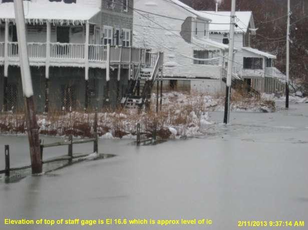
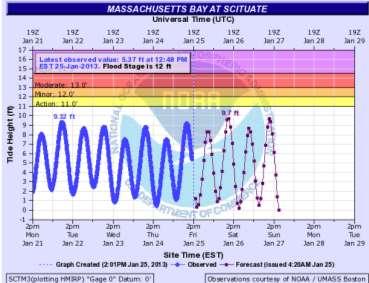
 Max storm surge = 4.78 feet (approx.")
33 Timing Matters! January 27, 2015 High Tide at Boston Storm Surge at max storm tide = 3.35 feet (3.12 feet at time of actual astronomical high tide) Max storm surge = 4.78 feet (approx. 30 minutes after time of low tide)
34 WHAT IF The storm was about 6 hours faster and peak surge occurred at high tide: = storm tide of feet MLLW Just above record water level of 15.1 feet MLLW set during the 1978 Blizzard The storm occurred the week before when we had a 12 foot MLLW astronomical tide: Potential storm tide near 16.8 feet (would bring us to unchartered territory)


35 And WAVES MATTER! Overwash Splashover Rule of thumb: Along exposed coast, overwash and splashover can become important when waves about 10 miles offshore reach 20 feet or more

36 Wave Overwash

37 Wave Battery Andrea Hotel and Resort


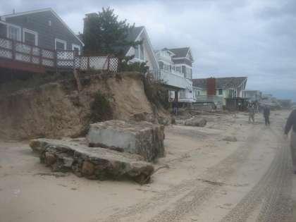
38 And Erosion Can Be a Big Issue Misquamicut Beach Westerly, RI (2 days after Sandy)


39 Wave Run-up Experimental program to help understand and forecast wave impact Empirical technique being applied to hot spots Oct Perfect Storm Boston Globe
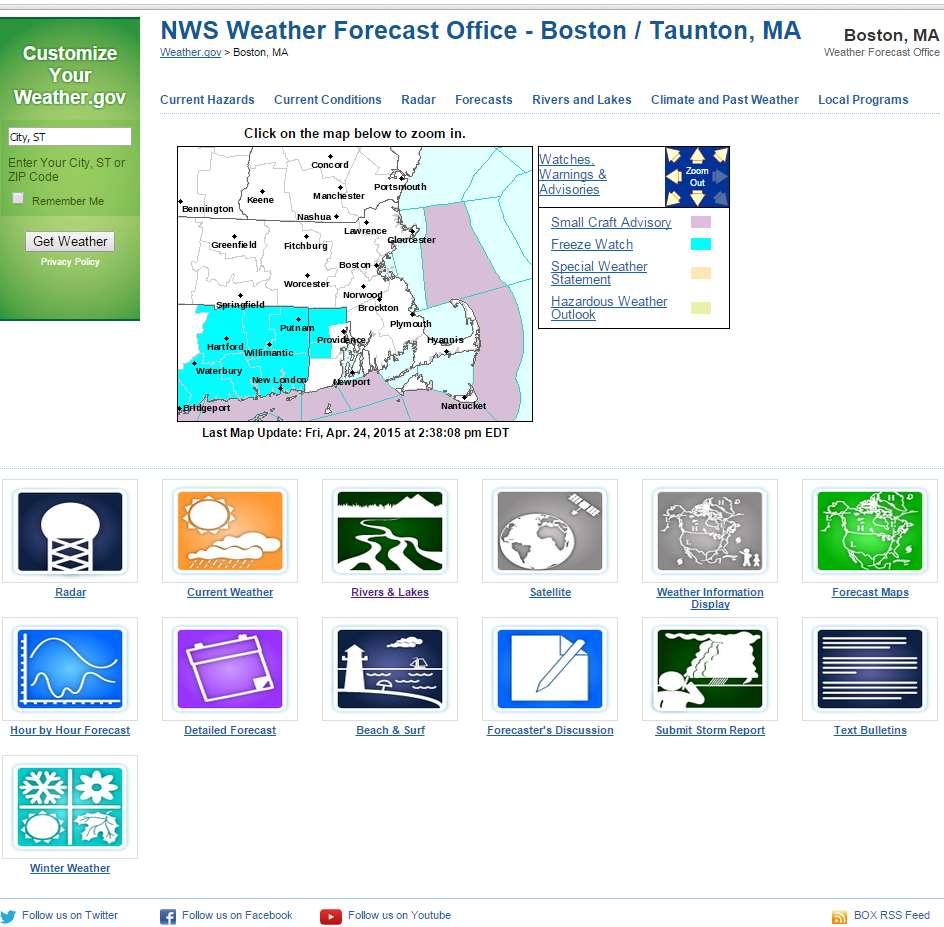
40 weather.gov/boston
41
42
43
44 COASTAL FLOOD HEADLINES Extratropical Storms (e.g. Nor easters) Coastal Flood Watch Potential for moderate or greater coastal flooding Generally 36 to 48 hours lead time Coastal Flood Warning Moderate or major coastal flooding likely/expected Generally 24 to 36 hours lead time Coastal Flood Advisory Minor coastal flooding likely/expected Generally 24 to 36 hours lead time


45 HEADLINE CRITERIA Minor Coastal Flood Advisory Moderate or Major = Coastal Flood Warning Minor Moderate Major
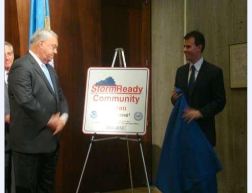
")
46 Coastal flood impacts appearing in TWLBOX are a function of water level and waves (derived from staff experience and local studies)
47 Product Example
48
49 weather.gov/boston
50 HAZARDOUS WEATHER OUTLOOK (HWO) Issued every early morning Potential hazardous weather out to 7 days May be your first clue of a local concern! Threat evolution May not appear too ominous at first (especially if time period is greater than 5 days) But let that be your signal for higher situational awareness Monitor evolution of threat with time (e.g. increasing or decreasing threat) Check HWO daily to maintain situational awareness
51 weather.gov/boston
52 AREA FORECAST DISCUSSION (AFD) Explains the rationale behind the warning and forecast decisions (i.e., the why of the forecast) Favorite product for many broadcast meteorologists Confidence level and degree of uncertainty May indicate alternative scenarios possible A way to get inside our heads

53 Area Forecast Discussion issued early Friday morning March 18, 2016
54 Rising sea level Looking to the Future Expect more frequent coastal flooding New record total water levels Raises the impact stakes

55 STORMREADY Boston May 20, 2009
56 WeatherReady Nation Goals Include Accurate and timely forecasts and warnings Integration of cutting edge science into operations Understanding of and effective response to weather information by partners/customers Emphasis on Impact Decision Support Services
57 Impact Decision Support Services Supports WeatherReady Nation goal Provide weather information that enables Americans to respond effectively to weather hazards and achieve high level of resilience Information to enable effective decisions by officials Public Safety Preservation of natural and human resources Take on different forms High Impact Storm Blast s (sometimes with Powerpoint Briefings), conference calls, Hazardous Weather Outlooks, Special Statements, social media posts, etc. Special Event Support Major such as July 3 rd -4 th Esplanade or Boston Marathon Smaller but still with significant public safety risk Regattas, concerts, sporting events, large flea markets, fairs, etc.
58 Take Away Thoughts Cape Cod vulnerable to both hurricanes and nor easters Hurricanes more extreme but nor easters more frequent Hurricanes usually greater threat to south side and nor easters usually greater threat to east side Inexperienced population Warning => Risk Too High => Take Action if vulnerable Expect more frequent and severe coastal flooding and erosion episodes with continued sea level rise
59 PREPAREDNESS!

60 Assess Vulnerability, Make Plan, and Act on Plan before too late!


61 Natural calamity strikes at just about the time that one forgets its terror. -- Japanese Proverb

62 Perfect Storm of October 1991 Courtesy Boston Globe THANK YOU!
HURRICANE IRENE. CONFERENCE CALL BRIEFING SLIDES Saturday August 27, :30 AM
 HURRICANE IRENE CONFERENCE CALL BRIEFING SLIDES Saturday August 27, 2011 8:30 AM NHC TRACK AND CONE HURRICANE IRENE WATCHES/WARNINGS Hurricane Warning along south coast including all of Cape Cod and Islands
NOAA s National Weather Service Philadelphia/Mt. Holly NJ
 Next Briefing Package: Friday, October 2, 2015 no later than 300 PM Hazards and Impacts: Overview: A dangerous weather pattern still threatens our region. Threats include very heavy rainfall, inland river
NOAA s National Weather Service Philadelphia/Mt. Holly NJ
 Next Briefing Package: Thursday, October 1, 2015 no later than 300 PM Hazards and Impacts: Overview: A dangerous weather pattern is developing for our region. Threats include very heavy rainfall, inland
Tropical Update. 12 PM EDT Friday, October 7, 2016 Hurricane Matthew & Tropical Storm Nicole
 Tropical Update 12 PM EDT Friday, October 7, 2016 Hurricane Matthew & Tropical Storm Nicole This update is intended for government and emergency response officials, and is provided for informational and
Major Hurricane Matthew Briefing Situation Overview
 Major Hurricane Matthew Briefing Situation Overview At 5 p.m. Tuesday, Category 4 Hurricane Matthew was about 860 miles South-Southeast of Mayport, Florida, moving north around 10 mph. Maximum sustained
Tropical Update 6 AM EDT Friday, October 7, 2016 Hurricane Matthew & Hurricane Nicole
 Tropical Update 6 AM EDT Friday, October 7, 2016 Hurricane Matthew & Hurricane Nicole This update is intended for government and emergency response officials, and is provided for informational and situational
Significant Coastal Storm Today through Thursday, 11/7-8. Weather Briefing
 Significant Coastal Storm Today through Thursday, 11/7-8 Weather Briefing Prepared 10:00 am EST Wednesday, November 7, 2012 Presented by Gary Conte, Warning Coordination Meteorologist NOAA s National Weather
Tropical Update. 11 AM EDT Tuesday, October 9, 2018 Hurricane Michael, Tropical Storm Leslie, Tropical Storm Nadine
 Tropical Update 11 AM EDT Tuesday, October 9, 2018 Hurricane Michael, Tropical Storm Leslie, Tropical Storm Nadine This update is intended for government and emergency response officials, and is provided
Coastal Storms of the New Jersey Shore
 Coastal Storms of the New Jersey Shore Dr. Steven G. Decker Dept. of Environmental Sciences School of Environmental and Biological Sciences Rutgers University May 25, 2011 Overview Threats Historical Examples
Very Dangerous Coastal Storm Sandy October 28 th 31 st 2012
 Very Dangerous Coastal Storm Sandy October 28 th 31 st 2012 Prepared 600 PM EDT Monday October 29, 2012 Gary Szatkowski NOAA s NJ Forecast Office Weather.gov/phi Purpose of Briefing Briefing #11 for event
NWS HURRICANES June 3, 2015
 NWS HURRICANES June 3, 2015 Hurricane Season June 1 November 30 2 What s the concern? All tropical systems passing within 125nm of central Maryland since 1950 Mid-Atlantic Hurricanes Greatest Risk: August
Hurricane Matthew. Life Threatening Flash Flooding Likely. National Weather Service Wilmington NC. Josh Weiss, Meteorologist
 Hurricane Matthew Life Threatening Flash Flooding Likely Threat Assessment for northeast South Carolina & southeast North Carolina National Weather Service Wilmington NC 630 PM EDT Friday October 7, 2016
Hurricane Matthew Life Threatening Flash Flooding Likely
 Hurricane Matthew Life Threatening Flash Flooding Likely Threat Assessment for northeast South Carolina & southeast North Carolina National Weather Service Wilmington NC 12 AM EDT Saturday October 8, 2016
Tropical Storm Harvey: SE Texas Impacts
 Tropical Storm Harvey: SE Texas Impacts 10 AM CDT UPDATE Thursday, August 24, 2017 Prepared by: Dan Reilly, Brian Kyle PLEASE MUTE YOUR LINES AND DON T PUT ON HOLD! Situation Overview Tropical Storm Harvey
Storm Summary for Hurricane Joaquin
 Storm Summary for Hurricane Joaquin Wednesday, September 30, 2015 at 5 PM EDT (Output from Hurrevac, based on National Hurricane Center Forecast Advisory #12) Joaquin is currently a Category 1 hurricane
Major Hurricane Matthew Briefing Situation Overview
 Major Hurricane Matthew Briefing Situation Overview THIS IS NOW A WORST CASE STORM SURGE SCENARIO Catastrophic Damage is Anticipated for Coastal Areas. Major Hurricane Matthew is still expected to move
Tropical Update. 5 AM EDT Tuesday, September 12, 2017 Post-Tropical Cyclone Irma, Hurricane Jose, & Tropical Wave (10%)
") Tropical Update 5 AM EDT Tuesday, September 12, 2017 Post-Tropical Cyclone Irma, Hurricane Jose, & Tropical Wave (10%) This update is intended for government and emergency response officials, and is provided
Tropical Update 5 AM EDT Tuesday, September 12, 2017 Post-Tropical Cyclone Irma, Hurricane Jose, & Tropical Wave (10%) This update is intended for government and emergency response officials, and is provided
Active Weather Threat Halloween Week Nor easter October 28 th 31 st 2012
 Active Weather Threat Halloween Week Nor easter October 28 th 31 st 2012 Prepared 1130 AM EDT Wednesday, October 24, 2012 Gary Szatkowski NOAA s NJ Forecast Office Weather.gov/phi Purpose of Briefing Briefing
GC Briefing. Weather Sentinel Tropical Storm Michael. Status at 8 AM EDT (12 UTC) Today (NHC) Discussion. October 11, 2018
 Today (NHC) Discussion. October 11, 2018") GC Briefing Weather Sentinel Tropical Storm Michael October 11, 2018 After making landfall as a high-end category-4 hurricane on the Florida Panhandle, Michael weakened to tropical storm status early this
GC Briefing Weather Sentinel Tropical Storm Michael October 11, 2018 After making landfall as a high-end category-4 hurricane on the Florida Panhandle, Michael weakened to tropical storm status early this
Tropical Storm Ana. Created 6:00 AM Sun May 10, 2015 John Cole Warning Coordination Meteorologist
 Tropical Storm Ana Threat Assessment for Eastern North Carolina Created 6:00 AM Sun May 10, 2015 John Cole Warning Coordination Meteorologist John.cole@noaa.gov National Weather Service Newport/Morehead
Hurricane Sandy October 28 th 31 st 2012
 Hurricane Sandy October 28 th 31 st 2012 Prepared 530 PM EDT Saturday October 27, 2012 Gary Szatkowski NOAA s NJ Forecast Office Weather.gov/phi Purpose of Briefing Briefing #7 for event Promote situational
Hurricane Matthew. National Weather Service Wilmington NC. Steven Pfaff, WCM.
 Hurricane Matthew Threat Assessment for northeast South Carolina & southeast North Carolina National Weather Service Wilmington NC 730 AM EDT Tuesday October 4, 2016 Steven Pfaff, WCM Steven.Pfaff@noaa.gov
Canadian Hurricane Center: How NHC Products are used to issue Warnings and Communicate Hazards
 Canadian Hurricane Center: How NHC Products are used to issue Warnings and Communicate Hazards Bob Robichaud Warning Preparedness Meteorologist Canadian Hurricane Centre Contents Brief background on the
Storm Surge Forecast with Shifting Forecast Tracks
 Storm Surge Forecast with Shifting Forecast Tracks Storm Surge Findings in the Florida Keys Jon Rizzo Warning Coordination Meteorologist National Weather Service Florida Keys Florida Keys Life History
Weather Briefing. Coastal Storm Monday-Wednesday Dec 8-10, National Weather Service. Prepared 12/8/14 6:30 AM
 Weather Briefing Coastal Storm Monday-Wednesday Dec 8-10, 2014 National Weather Service http://www.weather.gov/nyc Prepared 12/8/14 6:30 AM Overview of Potential Hazards A strong low pressure system will
Tropical Update. 11 AM EDT Wednesday, October 10, 2018 Hurricane Michael, Hurricane Leslie & Tropical Storm Nadine, Caribbean Low (40%)
") Tropical Update 11 AM EDT Wednesday, October 10, 2018 Hurricane Michael, Hurricane Leslie & Tropical Storm Nadine, Caribbean Low (40%) This update is intended for government and emergency response officials,
Tropical Update 11 AM EDT Wednesday, October 10, 2018 Hurricane Michael, Hurricane Leslie & Tropical Storm Nadine, Caribbean Low (40%) This update is intended for government and emergency response officials,
Subtropical Storm Ana
 Subtropical Storm Ana Threat Assessment for northeast South Carolina & southeast North Carolina Created 745 AM Fri May 8, 2015 Reid Hawkins, Science Officer National Weather Service Wilmington, NC 1 New
Hurricane Matthew Threats and Impacts Briefing for Eastern NC
 Hurricane Matthew Threats and Impacts Briefing for Eastern NC October 6 th, 2016 Date/Time Created: 10/6/2016, Noon EDT National Weather Service Newport/Morehead City, NC Hurricane Matthew Key Points Changes
Tropical Update. 5 PM EDT Thursday, September 7, 2017 Hurricane Irma, Hurricane Jose, and Hurricane Katia
 Tropical Update 5 PM EDT Thursday, September 7, 2017 Hurricane Irma, Hurricane Jose, and Hurricane Katia This update is intended for government and emergency response officials, and is provided for informational
Tropical Update. 5 PM EDT Sunday, October 7, 2018 Tropical Storm Michael, Tropical Storm Leslie, & Invest 92L (30%)
") Tropical Update 5 PM EDT Sunday, October 7, 2018 Tropical Storm Michael, Tropical Storm Leslie, & Invest 92L (30%) This update is intended for government and emergency response officials, and is provided
Tropical Update 5 PM EDT Sunday, October 7, 2018 Tropical Storm Michael, Tropical Storm Leslie, & Invest 92L (30%) This update is intended for government and emergency response officials, and is provided
Hurricane Harvey: SE Texas Impacts. 10 PM CDT UPDATE Friday, August 25, 2017 Prepared by: Lance Wood
 Hurricane Harvey: SE Texas Impacts 10 PM CDT UPDATE Friday, August 25, 2017 Prepared by: Lance Wood Latest Observations Hurricane Harvey making landfall this evening near Rockport as a category 4 hurricane.
Frank Revitte National Weather Service. Weather Forecast Office New Orleans/Baton Rouge
 Frank Revitte National Weather Service Weather Forecast Office New Orleans/Baton Rouge Above normal activity 17 Total Named Storms 7 Tropical Storms 4 Hurricanes 6 Major Hurricanes Not the most active,
Coastal Storm this Weekend
 Weather Briefing Prepared 9 AM EST Feb 5, 2010 Joe Miketta Warning Coordination Meteorologist NOAA s National Weather Service Philadelphia/Mt. Holly NJ Forecast Office 609-261 261-6602 6602 x223 Joseph.Miketta@noaa.gov
Weather briefing Strong Coastal Nor easter November 7 th -8 th, 2012
 Weather briefing Strong Coastal Nor easter November 7 th -8 th, 2012 Prepared 1245 PM EDT Tuesday November 6, 2012 Gary Szatkowski NOAA s NJ Forecast Office Weather.gov/phi Purpose of Briefing Briefing
Tropical Update. 5 AM EDT Thursday, September 7, 2017 Hurricane Irma, Hurricane Jose, and Hurricane Katia
 Tropical Update 5 AM EDT Thursday, September 7, 2017 Hurricane Irma, Hurricane Jose, and Hurricane Katia This update is intended for government and emergency response officials, and is provided for informational
Advisory #35 Briefing 630 PM EDT Thursday October 06, 2016
 Advisory #35 Briefing 630 PM EDT Thursday October 06, 2016 Disclaimer: The information contained within this briefing is time-sensitive, do not use beyond 6 hours after the issuance Next Webinar Update:
Satellite and Radar. 5:55 am Infrared Satellite with Surface Wind Arrows. 6:15 am Ruskin Doppler Radar. Large southerly wind field
 Satellite and Radar 5:55 am Infrared Satellite with Surface Wind Arrows 6:15 am Ruskin Doppler Radar Large southerly wind field Developing showers rotating onshore NHC Forecast Hurricane Warning Big Bend
Hurricane Matthew Page 1 Location Forecast Analysis Summary Report - Advanced Wind Estimation On
 Page 1 Current NHC Forecast Predictions Maximum Sustained Winds / Storm Category: 138 MPH / Category 4 Forward motion: 9 mph towards the North Hurricane Force winds extend from the center: 46 miles Tropical
TROPICAL STORM NATE BRIEFING
 TROPICAL STORM NATE BRIEFING 5:00 AM CDT Friday, October 6, 2017 Prepared by: NWS NWSNewOrleans www.weather.gov/neworleans Situation Overview No significant changes to the track forecast this morning.
Weather Briefing Mixed Winter Storm Event February 26-27, 2013
 Weather Briefing Mixed Winter Storm Event February 26-27, 2013 Prepared 1200 PM EST Tuesday, February 26th, 2013 Joe Miketta NOAA s NJ Forecast Office http://www.erh.noaa.gov/phi/ Purpose of Briefing Briefing
WEDNESDAY 30 TH AUGUST, :57 p.m. Tropical Storm Irma forms in the Atlantic. Don t let your guard down, always #Be Ready.
 Chapter 1 - The Set Up In the days leading up to Irma a series of composed and sobering text messages, presented in truncated form below, from Department of Disaster Management warned us of the pending
UNDERSTANDING COASTAL GEOLOGIC HAZARDS, SEA LEVEL RISE and CLIMATE CHANGE in THE NORTHEASTERN US
 UNDERSTANDING COASTAL GEOLOGIC HAZARDS, SEA LEVEL RISE and CLIMATE CHANGE in THE NORTHEASTERN US Congressional Hazards Caucus Briefing Washington, DC 18 November 2009 Jon C. Boothroyd Rhode Island Geological
Impact of Sea Level Rise on Future Storm-induced Coastal Inundation
 Impact of Sea Level Rise on Future Storm-induced Coastal Inundation Changsheng Chen School for Marine Science and Technology, University of Massachusetts-Dartmouth Email: c1chen@umassd.edu 04/14/2015 Outline
Tropical Update. 5 PM EDT Sunday, September 10, 2017 Hurricane Irma, Hurricane Jose, Tropical Wave (60%)
") Tropical Update 5 PM EDT Sunday, September 10, 2017 Hurricane Irma, Hurricane Jose, Tropical Wave (60%) This update is intended for government and emergency response officials, and is provided for informational
Tropical Update 5 PM EDT Sunday, September 10, 2017 Hurricane Irma, Hurricane Jose, Tropical Wave (60%) This update is intended for government and emergency response officials, and is provided for informational
Are You Ready For Hurricane Season? 2018 Hurricane Talk B Y : S T O R M T E A M 8 M E T E O R O L O G I S T J U L I E P H I L L I P S
 Are You Ready For Hurricane Season? 2018 Hurricane Talk B Y : S T O R M T E A M 8 M E T E O R O L O G I S T J U L I E P H I L L I P S About Me I am Currently a Weekday Meteorologist at WFLA Channel 8.
Tropical Weather Briefing
 Tropical Weather Briefing August 28, 2012 700 AM CDT National Weather Service Weather Forecast Office Slidell, LA Current Satellite Tropical Storm Isaac Watches/Warnings Tropical Storm Isaac Track Guidance
HURRICANE IRMA. 12 PM ET Saturday, September Prepared by: Kyle Thiem / Sid King.
 HURRICANE IRMA 12 PM ET Saturday, September 9 2017 Prepared by: Kyle Thiem / Sid King www.weather.gov/atlanta/briefings @NWSAtlanta www.weather.gov/atlanta Situation Overview 11:00 AM EDT Sat Sep 9 Location:
Hurricane Irma Page 1 HURRTRAK RM/Pro 2017 Summary Report for Tampa, FL 09/10/ EDT, Adv. # 46
 Hurricane Irma Page 1 Description of impact to Tampa, FL, Tampa, FL, is expected to receive a major impact from Hurricane Irma. The forecast maximum wind for this location has increased since the last
COASTAL DATA APPLICATION
 2015 Coastal GeoTools Proactive By Design. Our Company Commitment COASTAL DATA APPLICATION Projecting Future Coastal Flood Risk for Massachusetts Bay Bin Wang, Tianyi Liu, Daniel Stapleton & Michael Mobile
Hurricane Irma Page 1 HURRTRAK RM/Pro 2017 Summary Report for Tampa, FL 09/09/ EDT, Adv. # 43
 Hurricane Irma Page 1 Description of impact to Tampa, FL, Tampa, FL, is expected to receive a major impact from Hurricane Irma. The forecast maximum wind for this location has decreased since the last
Severe Weather Potential for Southeast Texas
 Severe Weather Potential for Southeast Texas Dan Reilly, Kent Prochazka, Scott Overpeck National Weather Service Houston/Galveston 10 am Synopsis Storm to likely bring severe weather to Southeast Texas
TROPICAL DEPRESSION HARVEY BRIEFING
 TROPICAL DEPRESSION HARVEY BRIEFING 10:15 PM CDT Wednesday, August 23, 2017 Prepared by: Lara Beal NWSCorpus www.weather.gov/corpuschristi Situation Overview No changes to Watches. Hurricane Watch remains
GC Briefing. Weather Sentinel Hurricane Florence. Status at 5 PM EDT (21 UTC) Today (NHC) Discussion. September 13, 2018
 Today (NHC) Discussion. September 13, 2018") GC Briefing September 13, 2018 Weather Sentinel Hurricane Florence Tropical storm conditions have been reported for areas of North Carolina and will continue to spread inland to the west and south. Hurricane
GC Briefing September 13, 2018 Weather Sentinel Hurricane Florence Tropical storm conditions have been reported for areas of North Carolina and will continue to spread inland to the west and south. Hurricane
Storm Summary for Hurricane Jose
 Storm Summary for Hurricane Jose Tuesday, September 19, 2017 at 11 AM EDT (Output from Hurrevac, based on National Hurricane Center Forecast Advisory #57) Jose is currently a Category 1 hurricane on the
The Wind Hazard: Messaging the Wind Threat & Corresponding Potential Impacts
 The Wind Hazard: Messaging the Wind Threat & Corresponding Potential Impacts Scott Spratt Warning Coordination Meteorologist NWS Melbourne, FL David Sharp Science & Operations Officer NWS Melbourne, FL
Prolonged Coastal Storm October 9 th -12 th, 2013
 Prolonged Coastal Storm October 9 th -12 th, 2013 Prepared 400 PM EDT Tuesday, October 8th, 2013 Gary Szatkowski NOAA s NJ Forecast office http://www.erh.noaa.gov/phi/ Purpose of Briefing Briefing #1 for
A Perfect Storm: The Collision of Tropical Cyclones, Climate Change and Coastal Population Growth. Jeff Donnelly Woods Hole Oceanographic Institution
 A Perfect Storm: The Collision of Tropical Cyclones, Climate Change and Coastal Population Growth Jeff Donnelly Woods Hole Oceanographic Institution Recent Hurricane Trends What Might the Future Hold?
RSMC-Miami Update Daniel Brown Warning Coordination Meteorologist
 RSMC-Miami Update 2016 Daniel Brown Warning Coordination Meteorologist L-0324 Emergency Management Hurricane Preparedness Training Course Funding provided by FEMA s National Hurricane Program - partnership
Coastal Storm Potential
 Coastal Storm Potential Event Date/Time: 11/12/2009-11/14/2009 Today through Saturday National Weather Service Newport/Morehead City, NC Date: 11/12/2009 1000 am Coastal Storm Remnants of Ida, coupled
Weather briefing Strong Coastal Nor easter November 7 th -8 th, 2012
 Weather briefing Strong Coastal Nor easter November 7 th -8 th, 2012 Prepared 1215 PM EDT Wednesday November 7, 2012 Gary Szatkowski NOAA s NJ Forecast Office http://www.erh.noaa.gov/phi/ Purpose of Briefing
IWT Scenario 2 Integrated Warning Team Workshop National Weather Service Albany, NY October 31, 2014
 IWT Scenario 2 Integrated Warning Team Workshop National Weather Service Albany, NY October 31, 2014 09 10 11 12 13 Scenario 2 Timeline December 9-13 Tue Wed Thu Fri Sat Tue, Dec. 9 @ 5 am 2014 2014 2014
A Prepared Marylander Creates a Resilient Maryland
 Maryland Emergency Management Agency Operations Directorate Hazardous Winter Weather Outlook Briefing March 5, 2013 0800 A Prepared Marylander Creates a Resilient Maryland A strong low pressure will track
Tropical Storm Ana. Created 615 AM Sat May 9, 2015 Reid Hawkins, Science Officer
 Tropical Storm Ana Threat Assessment for northeast South Carolina & southeast North Carolina Created 615 AM Sat May 9, 2015 Reid Hawkins, Science Officer National Weather Service Wilmington, NC 1 New Information
Nor easter Monday Night Wednesday December 8 10, 2014
 Nor easter Monday Night Wednesday December 8 10, 2014 Prepared 400 PM EST Monday, December 8, 2014 Mitchell Gaines NOAA s Philadelphia/Mount Holly NJ Forecast Office www.weather.gov/phi/ Purpose of Briefing
HURRICANE HARVEY COE Navigation BRIEFING
 HURRICANE HARVEY COE Navigation BRIEFING 10:00 AM CDT Friday, August 25, 2017 NWSNewOrleans www.weather.gov/neworleans Situation Overview New Information Harvey continues to strengthen Max sustained winds
Tropical Update. 5 AM EDT Monday, October 8, 2018 Tropical Storm Michael, Tropical Storm Leslie, Invest 92L (10%) & African Tropical Wave (50%)
 & African Tropical Wave (50%)") Tropical Update 5 AM EDT Monday, October 8, 2018 Tropical Storm Michael, Tropical Storm Leslie, Invest 92L (10%) & African Tropical Wave (50%) This update is intended for government and emergency response
Tropical Update 5 AM EDT Monday, October 8, 2018 Tropical Storm Michael, Tropical Storm Leslie, Invest 92L (10%) & African Tropical Wave (50%) This update is intended for government and emergency response
SLOSH New Orleans Basin 2012 Update
 SLOSH New Orleans Basin 2012 Update Michael Koziara Science and Operations Officer National Weather Service Slidell, LA The Basics What is storm surge? What is SLOSH? Details Assumptions Inundation = Storm
TROPICAL STORM NATE BRIEFING
 TROPICAL STORM NATE BRIEFING 10:30 AM CDT Friday, October 06, 2017 Prepared by: NWS NWSNewOrleans www.weather.gov/neworleans Situation Overview Track forecast has shifted slightly eastward. Hurricane Watch
David R. Vallee Hydrologist-in-Charge NOAA/NWS Northeast River Forecast Center
 David R. Vallee Hydrologist-in-Charge NOAA/NWS Northeast River Forecast Center From a Practitioner s Perspective Touch upon some of our major flood events of the past 10 years Part I: Big Rainstorms &
Hurricane Matthew. National Weather Service Wilmington NC. Steven Pfaff, WCM.
 Hurricane Matthew Threat Assessment for northeast South Carolina & southeast North Carolina National Weather Service Wilmington NC 515 PM EDT Monday October 3, 2016 Steven Pfaff, WCM Steven.Pfaff@noaa.gov
Major Hurricane Earl
 Major Hurricane Earl Advisory 32 North Carolina Threat Assessment Prepared at: 8 AM Thursday September 2, 2010 Hurricane and Tropical Storm Warnings in effect for the North Carolina Coast and Sounds. NWS
Tropical Update. 5 AM EDT Wednesday, September 6, 2017 Hurricane Irma, Tropical Storm Jose, and Tropical Storm Katia
 Tropical Update 5 AM EDT Wednesday, September 6, 2017 Hurricane Irma, Tropical Storm Jose, and Tropical Storm Katia This update is intended for government and emergency response officials, and is provided
CLIMATE READY BOSTON. Climate Projections Consensus ADAPTED FROM THE BOSTON RESEARCH ADVISORY GROUP REPORT MAY 2016
 CLIMATE READY BOSTON Sasaki Steering Committee Meeting, March 28 nd, 2016 Climate Projections Consensus ADAPTED FROM THE BOSTON RESEARCH ADVISORY GROUP REPORT MAY 2016 WHAT S IN STORE FOR BOSTON S CLIMATE?
TROPICAL STORM NATE BRIEFING
 TROPICAL STORM NATE BRIEFING 2:00 PM CDT Friday, October 06, 2017 Prepared by: NWS NWSNewOrleans www.weather.gov/neworleans Situation Overview Track forecast has not changed since the 10 am advisory. Hurricane
This Season s Reminder of
 This Season s Reminder of Northeast Hurricane Risk 09.2009 By AIRCurrents Editor s note: The 2009 Atlantic Hurricane Season got off to a surprisingly slow start. Then, all within a week, mid-august brought
Coastal Storm. Wednesday through Friday, 3/6-8/2013 Weather Briefing
 Coastal Storm Wednesday through Friday, 3/6-8/2013 Weather Briefing Prepared 2:00 PM EST Wednesday, March 6, 2013 National Weather Service New York, NY Purpose of Briefing Promote Situational Awareness
HURRICANE NATE BRIEFING
 HURRICANE NATE BRIEFING 2:00 PM CDT Saturday, October 07, 2017 Prepared by: NWS NWSNewOrleans www.weather.gov/neworleans Situation Overview continues to intensify. It is now forecast to be a category 2
Planning for the Threat Preparing for the Impacts The Role of the Local Forecast
 Planning for the Threat Preparing for the Impacts The Role of the Local Forecast 2014 Florida Governor Hurricane Conference Pablo Santos NOAA/NWS WFO Miami, FL 2014 - FLGHC 2014 - FLGHC Decision Support
Current Details from the National Hurricane Center (NHC)
") Current Watches and Warnings A Hurricane Warning is in effect from South Santee River, South Carolina (SC) to Duck, North Carolina (NC); Albemarle and Pamlico Sounds A Hurricane Watch is in effect from
Current Watches and Warnings A Hurricane Warning is in effect from South Santee River, South Carolina (SC) to Duck, North Carolina (NC); Albemarle and Pamlico Sounds A Hurricane Watch is in effect from
NWS Resources For School Districts
 NWS Resources For School Districts January 23rd, 2017 Shawn DeVinny shawn.devinny@noaa.gov Meteorologist National Weather Service Twin Cities/Chanhassen, MN Outline Watches/Warnings/Advisories Example
CATEX Hurricane Zachary
 CATEX Hurricane Zachary EXERCISE, EXERCISE,EXERCISE East Coast CATEX Power Restoration Functional Exercise 2013 This document was prepared under a grant from FEMA's Grants Programs Directorate, U.S. Department
Diagnosing the Large Swell Event Associated with the Extratropical Transition of Hurricane Florence
 Diagnosing the Large Swell Event Associated with the Extratropical Transition of Hurricane Florence Mark Willis National Hurricane Center Tropical Analysis and Forecast Branch (TAFB) Thanks to: Jack Beven,
NOAA s National Weather Service Philadelphia/Mt. Holly NJ. Summary. Changes
 Summary A crippling and potentially historic east coast snow storm will lead to blizzard conditions and major coastal flooding for portions of the area this weekend. Changes Blizzard Warning has been expanded
Major Hurricane Earl
 Major Hurricane Earl Advisory 33 North Carolina Threat Assessment Prepared at: 11 AM Thursday September 2, 2010 Hurricane and Tropical Storm Warnings in effect for the North Carolina Coast and Sounds NWS
Hurricane Harvey: SE Texas Impacts. 10 AM CDT UPDATE Saturday, August 26, 2017 Prepared by: Dan Reilly, Brian Kyle
 Hurricane Harvey: SE Texas Impacts 10 AM CDT UPDATE Saturday, August 26, 2017 Prepared by: Dan Reilly, Brian Kyle Latest Observations and Radar Hurricane Harvey centered near Victoria and weakening Wind
Complete Weather Intelligence for Public Safety from DTN
 Complete Weather Intelligence for Public Safety from DTN September 2017 White Paper www.dtn.com / 1.800.610.0777 From flooding to tornados to severe winter storms, the threats to public safety from weather-related
Tropical Cyclone Hazards. Presentation
 Tropical Cyclone Hazards Presentation Kerry N Mallory AE5JY September 7, 2011 Tropical Cyclone Hazards The Four Primary Weapons of a Tropical Cyclone are: 1. Wind 2. Storm Surge 3. Rain/Freshwater Flooding
Hurricanes. Environmental Geology Mr. Paul Lowrey. Stacey Singleton, Cassandra Combs, Dwight Stephenson, Matt Smithyman
 Environmental Geology Mr. Paul Lowrey Stacey Singleton, Cassandra Combs, Dwight Stephenson, Matt Smithyman Hurricanes EMPACTS Project, Spring 2017 Northwest Arkansas Community College, Bentonville, AR
2017 Hurricane Season and Beyond
 2017 Hurricane Season and Beyond Ken Graham National Hurricane Center Building a Weather-Ready Nation Much of U.S. Coast Saw Tropical Wind Watches or Warnings 2017 Hurricane Season Facts and Figures 7th
Welcome Jeff Orrock Warning Coordination Meteorologist National Weather Service Raleigh
 Welcome Jeff Orrock Warning Coordination Meteorologist National Weather Service Raleigh Jeff.orrock@noaa.gov Sources: Operational Significant Event Imagery and the Environmental Applications Team (EAT)
Wind field has expanded and is very large. Hurricane Wind field = 100 miles wide, Tropical Storm Wind field = 360 miles wide
 HURRICANE IRMA 12 PM ET Sunday, September 10 2017 Prepared by: Keith Stellman / Kyle Thiem www.weather.gov/atlanta/briefings @NWSAtlanta www.weather.gov/atlanta Situation Overview 11:10 AM EDT Sun Sep
Atlantic Basin Satellite Image
 Tropical Update 11 AM EDT Friday, September 7, 2018 Tropical Depression Gordon, Tropical Storm Florence, Potential Tropical Cyclone #8 (90%), Invest 92L (90%) This update is intended for government and
What s s New for 2009
 What s s New for 2009 Graphical Tropical Weather Outlook becomes operational Special Tropical Disturbance Statement replaced with Special Tropical Weather Outlook Tropical Cyclone Wind Field Graphic becomes
Heavy Rain and Potential for Dangerous Flooding for northeast SC and southeast NC
 US National Weather Service Wilmington NC @NWSWilmingtonNC http://weather.gov/ilm ***Life Threatening Flooding Possible*** Heavy Rain and Potential for Dangerous Flooding for northeast SC and southeast
Canes on Canes: Keeping South Florida Prepared During the Calm Before the Storm. Matt Onderlinde and Pete Finocchio
 Canes on Canes: Keeping South Florida Prepared During the Calm Before the Storm Matt Onderlinde and Pete Finocchio Outline The Science of Hurricanes Why and When South Floridians Must Be Weather-Ready
Tropical Update. 5 PM EDT Tuesday, September 5, 2017 Hurricane Irma, Tropical Storm Jose, and Tropical Depression Thirteen
 Tropical Update 5 PM EDT Tuesday, September 5, 2017 Hurricane Irma, Tropical Storm Jose, and Tropical Depression Thirteen This update is intended for government and emergency response officials, and is
Name Earth Science Pd. Hurricanes. Directions: Read the information, view diagrams and answer the questions in the worksheet.
 Hurricanes Directions: Read the information, view diagrams and answer the questions in the worksheet. Hurricane Basics The ingredients for a hurricane include a pre-existing weather disturbance, warm tropical
Significant Flooding Expected
 Significant Flooding Expected Decision Support Briefing #5 As of: 9:00 AM September 14, 2018 What Has Changed? Flash Flood Watch now in effect for part of area, will be expanded later today 9/14/2018 9:23
IWT Scenario 1 Integrated Warning Team Workshop National Weather Service Albany, NY October 31, 2014
 Integrated Warning Team Workshop National Weather Service Albany, NY October 31, 2014 23 24 25 26 27 Scenario 1 Timeline November 23-27 Sun Mon Tue Wed Thu Thanksgiving Day Sunday, Nov. 23 @ 430 pm NWS
Storms. 3. Storm types 4. Coastal Sectors 5. Sorm Location and Seasonality 6. Storm Severity 7. Storm Frequency and grouping 8. The design storm event
 1. Introduction Storms 2. The Impact of Storms on the coast 3. Storm types 4. Coastal Sectors 5. Sorm Location and Seasonality 6. Storm Severity 7. Storm Frequency and grouping 8. The design storm event