Institutionalization of Space Activities I. R. Iran
|
|
|
- Josephine Stephens
- 5 years ago
- Views:
Transcription
1 Institutionalization of Space Activities in I. R. Iran Parviz Tarikhi Head, Office for Specialized International Cooperation on Space Applications, Iranian Remote Sensing Center October 2002

2 The background of Man s attention to space goes to the early days of the human history. Wishing to fly in the sky and travel to space is a common idea not only in the myths but also in human religions.

.")
3 Kay Kāvus flies in the sky using the power of the hungry eagles (Shahnameh-e Ferdowsi, Persian Epics ). Religious ascent
4 Man has paid great attention to astronomy, mathematics, art and literature thanks to his interest in space. There are many signs and documents about the attention and interest of the Iranian poets to space that can be seen in their works.

5 Since when Sputnik orbited the Earth in 1957, many thousands of satellites have been launched.
6 Space technology is very important in our modern life. Its social, economic, political and cultural effects are very evident. I do not wish to be interrogated in this concern, but we have invested bus$ 35 to bus$ 40 in the space program, and disregarding the knowledge we have gained through imaging from space, we have benefited ten times of what we have invested. L. Johnson, Former US President
7 More than 3500 satellites currently in space 577 bus$ absorbed by space technology in
8 Satellite data for: Promotion of knowledge about the environment, Earth, and the Universe. New technologies increase new applications that are beneficial for the life on Earth.
9 Functionality of the satellites Application Satellites Global positioning Satellites Earth Observation Satellites Scientific and exploration Satellites Telecommunication Satellites

10 Application Satellites Weather satellites to predict storms, hurricanes, floods, cyclones, tidal waves, and forest fires

11 Global positioning Satellites Navigation

12 Earth Observation Satellites Monitoring the Earth resources

 IKONOS (High")
13 Earth Observation Satellites Monitoring the Earth resources Increasing spatial, spectral and temporal resolution Spatial resolution, under 1 meter Spectral resolution, multiple spectral bands Temporal resolution, shortening the repeat time Mighty-Sat (Hyper spectral) IKONOS (High resolution)

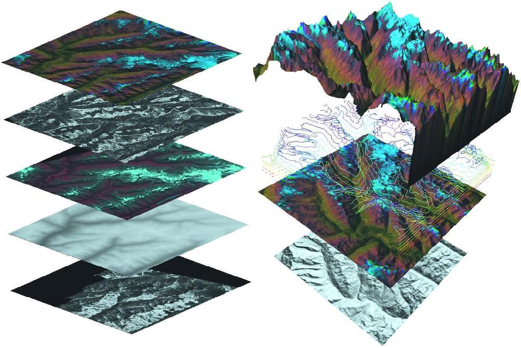
14 Earth Observation Satellites Monitoring the Earth resources Applying new technologies: Radar technology such as SAR Interferometry LIDAR, Laser remote sensing X-ray remote sensing Non-electromagnetic remote sensing using gravity and sound waves SAR Interferogram generated from ERS data

15 Earth Observation Satellites Monitoring the Earth resources By 2004 The Middle East contributed to 60% of the demand for highresolution remote sensing data; it is still increasing Most of the countries in the region benefit their own telecom satellites. Israel and Pakistan have their own Remote Sensing satellites. Using telecom and Remote Sensing satellites in the Far East region is very widespread.

16 Scientific and exploration satellites Hubble Space Telescope Hubble Space Telescope


17 Scientific and exploration satellites Hubble Space Telescope Satellites for studying Earth and other planets Terra Mars Mariner

18 Scientific and exploration satellites Hubble Space Telescope Satellites for studying Earth and other planets Space Stations such as MIR Space Station With 130 tons of weight and 15 years of service different scientific and application experiments and creating 600 industrial technologies International Space Station is now in service and follows the functions of MIR Space Station. MIR Space Station

19 Telecommunication Satellites TV broadcasting

20 Telecommunication Satellites TV broadcasting Voice and data

21 Telecommunication Satellites TV broadcasting Voice and data 5200 transponders used in 2000 and 8814 transponders planned to be used in 2010 Year 2000: 2766 units for TV and Video broadcasting, 2140 units for voice and data and 294 for the Internet Year 2010: 4661 units for TV and Video broadcasting, 1763 units for voice and data and 2390 for the Internet
22 An increasing and promising attention is given to the application of space technologies in recent decade in Iran.
23 Iran joins other 17 countries of the world in 1958 to found the Committee on International Cooperation in Space. The Committee later changes its name to the Committee of Peaceful Uses of Outer Space (COPUOS). Iran has ever hold its peaceful position on the applications of space science and technology. Iran is the continuous contributor to COPUOS deliberations.
.")
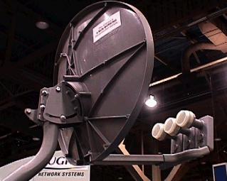
24 Iran enters the space applications era in 1969 through establishing Asad Abad Ground Station by installing a 30m-diameter standard A antenna to connect to the pacific Intelsat for international communications. Mahdasht Satellite Receiving Station is established in 1972 following the launch ERTS (Landsat-1). The Station is among the only 5 stations around the world at the date.
25 Telecommunications, TV broadcasting, remote sensing, navigation, teleeducation, weather forecasting, environmental modeling, Internet, relief and rescue, and so on are common applications of space technology that have been well spread in Iran.
26 Environmental Modeling

27 relief and rescue
28 In telecommunications, there are three communications networks in Iran with more than 1000 ground stations providing voice and data services to the users.

29 In telecommunications, for example only the number of fixed communication lines from 9,000,000 in year 2000 will grow to 12,000,000 in Nearly 1 of 5 of the Iranian population will own a phone line thanks to the availability of space communication technology in Iran The telecommunication network of Iran is one of the greatest networks in the Middle East.
30 Institutionalizing the space activities in the Islamic Republic of Iran, a vital necessity
31 The Iranian Remote Sensing Center affiliated to the Ministry of Telecommunications and Information Technology in cooperation with the other related bodies committed to establish the Iranian Space Agency in February Presently the issues concerning the parliamentary approvals are going on successfully and promisingly. The Agency has now its Statute.
32 By the establishment of the Iranian Space Agency all the space related activities in the Islamic Republic of Iran is covered by this organization.
33 Thank You
Fifty Years of Operational Environmental Satellites: The U.S. Experience
 United Nations Committee on the Peaceful Uses of Outer Space Vienna, Austria June 15, 2010 Fifty Years of Operational Environmental Satellites: The U.S. Experience Mr. Charles Baker Deputy Assistant Administrator
MISCONCEPTIONS ABOUT SATELLITES AND MORE
 MISCONCEPTIONS ABOUT SATELLITES AND MORE 1. All satellites are man- made. (F) A satellite is an object that moves around a larger object. Earth is a satellite because it moves around the sun. The moon
National Report on Weather Forecasting Service
 MINISTRY OF WATER RESOURCES AND METEOROLOGY DEPARTMENT OF METEOROLOGY, CAMBODIA National Report on Weather Forecasting Service Tokyo, 11-15 March 2014 Department of Meteorology, Cambodia Presentation Outline
8.11 Satellites. Figure 1 Artifi cial satellites provide valuable monitoring and communication services for humankind.
 8.11 Satellites As you know, Earth has one natural satellite orbiting it the Moon. Earth also has thousands of other satellites circling it at different altitudes and orbits, but these are all made by
Chapter 10 Space Exploration Page 1 of 6
 Page 1 of 6 Astronomy - Field of study about natural objects in the sky Astronomer Year Contribution to the field of Astronomy Aristotle 384 322 BC Suggested the Earth is spherical in shape & not flat
Mobile and Wireless Networks Course Instructor: Dr. Safdar Ali
 Mobile and Wireless Networks Course Instructor: Dr. Safdar Ali Satellite Communication INTRODUCTION INTRODUCTION Communication satellite are off-course only one means of telecommunication transmission.
Unit 5 Lesson 1 Images from Space. Copyright Houghton Mifflin Harcourt Publishing Company
 Florida Benchmarks SC.8.N.4.2 Explain how political, social, and economic concerns can affect science, and vice versa. SC.8.E.5.10 Assess how technology is essential to science for such purposes as access
Resolutions from the Tenth United Nations Conference on the Standardization of Geographical Names, 2012, New York*
 UNITED NATIONS GROUP OF EXPERTS ON GEOGRAPHICAL NAMES Twenty-eighth session New York, 28 April 2 May 2014 GEGN/28/9 English Resolutions from the Tenth United Nations Conference on the Standardization of
Todays Topics 3/19/2018. Light and Telescope. PHYS 1403 Introduction to Astronomy. CCD Camera Makes Digital Images. Astronomical Detectors
 PHYS 1403 Introduction to Astronomy Light and Telescope Chapter 6 Todays Topics Astronomical Detectors Radio Telescopes Why we need space telescopes? Hubble Space Telescopes Future Space Telescopes Astronomy
The NEO problem: activities in Russia
 47th Session of UN COPUOS Vienna, Austria, February 2010 Scientific and Technical Subcommittee The NEO problem: activities in Russia Boris Shustov The Expert Working Group on the АСН Problem by the Space
I can use the formula which links distance, speed and time
 Done in class Revised Assessed I can use the formula which links distance, speed and time distance = speed x time d = v t d = distance (measured in metres, m) v = speed (measured in metres per second,
1( ) 8
 8") Beyond the Sky Human beings have gazed upon the sky for thousands of years. Ancient astronomers observed small lights in the night sky that moved among the stars, and called them planets, meaning wanderers..,.
Beyond the Sky Human beings have gazed upon the sky for thousands of years. Ancient astronomers observed small lights in the night sky that moved among the stars, and called them planets, meaning wanderers..,.
Benefits of the new-generation Himawari-8 geostationary satellite for the Asia-Pacific region. Toshihiko HASHIDA Japan Meteorological Agency (JMA)
") Benefits of the new-generation Himawari-8 geostationary satellite for the Asia-Pacific region Toshihiko HASHIDA Japan Meteorological Agency (JMA) Side Event Ensuring User Readiness to New-Generation Meteorological
Benefits of the new-generation Himawari-8 geostationary satellite for the Asia-Pacific region Toshihiko HASHIDA Japan Meteorological Agency (JMA) Side Event Ensuring User Readiness to New-Generation Meteorological
Space Exploration. Chapter. hapte
 Chapter Cha Chapter Chapte hapte pte p ter er 1 10 0 Space Exploration How can the model of the Solar System be improved from time to time? Give three examples of technological invention devices applied
Learning Lab Seeing the World through Satellites Eyes
 Learning Lab Seeing the World through Satellites Eyes ESSENTIAL QUESTION What is a satellite? Lesson Overview: Engage students will share their prior knowledge about satellites and explore what satellites
The MeerKAT-SKA schools competition Enter and stand a chance to WIN!
 The MeerKAT-SKA schools competition Enter and stand a chance to WIN! You could WIN A laptop/notebook An ipod A printer SKA SA branded clothing and bags For enquiries: Tel: (012) 392 9300 email:skacompetition@saasta.ac.za
The Spatial Information Corridor Contributes to UNISPACE+50. JIANG HUI Director of Internation Cooperation Department
 The Spatial Information Corridor Contributes to UNISPACE+50 JIANG HUI Director of Internation Cooperation Department 01 02 03 What is Belt & Road Spatial Information Corridor? China put forward the "Belt
Zoink Questions: Tools of Astronomy
 1. Optical telescopes are designed to do what? Gather and focus visible light to see distant objects more clearly 2. Visible light can be separated into various colors to form a(n). Spectrum 3. The full
HST AND BEYOND EXPLORATION AND THE SEARCH FOR ORIGINS: A VISION FOR ULTRAVIOLET- OPTICAL-INFRARED SPACE ASTRONOMY
 Chapter Ten HST AND BEYOND EXPLORATION AND THE SEARCH FOR ORIGINS: A VISION FOR ULTRAVIOLET- OPTICAL-INFRARED SPACE ASTRONOMY Bibliographic Information: Dressler, Alan, ed., HST and Beyond Exploration
WORLD DAY TO COMBAT DESERTIFICATION 2018 IN MONGOLIA
 WORLD DAY TO COMBAT DESERTIFICATION 2018 IN MONGOLIA This year the WDCD slogan was Land has true value. Invest in it to address the importance of sustainable land use, land degradation prevention and its
8. Which of the following can not be detected by modern telescopes? A. radio waves B. heat waves (infrared) C. light waves D.
 C. light waves D.") 7. Which is not an advantage of the Hubble Space Telescope? A. It is not effected by weather B. It is not effected by pollution C. It is not effected by light. D. It is closer to the stars 8. Which of
7. Which is not an advantage of the Hubble Space Telescope? A. It is not effected by weather B. It is not effected by pollution C. It is not effected by light. D. It is closer to the stars 8. Which of
The story of NASA. Presented by William Markham
 The story of NASA Presented by William Markham German Rocket Developments WW2 Comet ME 262 V1 flying bomb V2 Rocket Wernher Von Braun Early history An Act to provide for research into the problems of flight
Disaster Management in Mongolia
 The Third UN-GGIM-AP Plenary Meeting Disaster Management in Mongolia ~Coordination among NGIA & Other Related Organizations and Recommendations~ Bali Indonesia 10 November 2014 Khurelshagai Ayurzana, Director
IMPORTANCE OF SATELLITE DATA (FOR REANALYSIS AND BEYOND) Jörg Schulz EUMETSAT
 Jörg Schulz EUMETSAT") IMPORTANCE OF SATELLITE DATA (FOR REANALYSIS AND BEYOND) Jörg Schulz EUMETSAT Why satellite data for climate monitoring? Global coverage Global consistency, sometimes also temporal consistency High spatial
IMPORTANCE OF SATELLITE DATA (FOR REANALYSIS AND BEYOND) Jörg Schulz EUMETSAT Why satellite data for climate monitoring? Global coverage Global consistency, sometimes also temporal consistency High spatial
1. A rocket is a machine that uses escaping gas to move. P Konstantin Tsiolkovsky was a Russian high school teacher and the father of
 1. A rocket is a machine that uses escaping gas to move. P 598 2. Konstantin Tsiolkovsky was a Russian high school teacher and the father of rocketry. Although he explained how rocketry worked, he never
ESSE Payload Design. 1.2 Introduction to Space Missions
 ESSE4360 - Payload Design 1.2 Introduction to Space Missions Earth, Moon, Mars, and Beyond Department of Earth and Space Science and Engineering Room 255, Petrie Science and Engineering Building Tel: 416-736
Remote Sensing Through Satellite Technology
 1 Remote Sensing Through Satellite Technology REMOTE SENSING The study of something without making actual contact with the object Making measurements of the physical properties of an object from a remote
NASA s Activities in Europe
 NASA s Activities in Europe Presented by Dr. Bill Barry NASA European Representative November 10, 2009 at the 2009 International Workshop on Environment and Alternative Energy 2 Current Activities The
The Moon s relationship with Earth The formation of the Moon The surface of the Moon Phases of the Moon Travelling to the Moon
 The Moon The Moon s relationship with Earth The Moon orbits the Earth every 27.3 days. The tides on Earth are caused mostly by the gravitational pull of the Moon and the Sun. The Moon's gravitational pull
Gaps in Space Weather Forecasting
 Gaps in Space Weather Forecasting Awareness Gap: Where is there uncertainty about how the scientific community can contribute to space weather operations? Areas With Good Awareness - All agencies recognize
HISTORY OF HEAVY RAINFALL DISASTER INFORMATION IN JAPAN
 transmission, for a state-of-the-art review. In addition, issues expected to arise in the future are discussed. HISTORY OF HEAVY RAINFALL DISASTER INFORMATION IN JAPAN Progress of Rainfall Observation
Asia-Pacific ground-base Optical Satellite Observation System APOSOS
 Asia-Pacific ground-base Optical Satellite Observation System APOSOS Center for Research and Application of Space Debris National Astronomical Observatories, CAS GUO Xiaozhong Oct 2011 Outline Space debris
Earth Science: Chapter 2 Assessment
 Earth Science: Chapter 2 Assessment Do not write on this text booklet. Write the letter of the correct answer on your answer sheet. SECTION 1: Multiple Choice (50 points) Choose the letter of the BEST
(Refer Slide Time: 3:48)
") Introduction to Remote Sensing Dr. Arun K Saraf Department of Earth Sciences Indian Institute of Technology Roorkee Lecture 01 What is Satellite based Remote Sensing Hello, hello everyone this is Arun
Introduction to Remote Sensing Dr. Arun K Saraf Department of Earth Sciences Indian Institute of Technology Roorkee Lecture 01 What is Satellite based Remote Sensing Hello, hello everyone this is Arun
!"#$%&' #(!()* +,-'.,$ &%!/(%)!'%
* +,-'.,$ &%!/(%)!'%") !"#$%&' #(!()* +,-'.,$ &%!/(%)!'% /01234 5013673 Iranian Remote Sensing Center (IRSC) No. 22, 14 th Street, Saadat-Abad Tehran 19979, Iran Tel: +98 21 2063207 Fax: +98 21 2064474 E-mail: irsc@www.dci.co.ir
!"#$%&' #(!()* +,-'.,$ &%!/(%)!'% /01234 5013673 Iranian Remote Sensing Center (IRSC) No. 22, 14 th Street, Saadat-Abad Tehran 19979, Iran Tel: +98 21 2063207 Fax: +98 21 2064474 E-mail: irsc@www.dci.co.ir
International Cooperation in Operational Environmental Satellites: The U.S. Experience
 Committee on the Peaceful Uses of Outer Space Science and Technology Sub committee Forty seventh session February 17, 2010 Vienna, Austria International Cooperation in Operational Environmental Satellites:
orbit 1 of 6 For the complete encyclopedic entry with media resources, visit:
 This website would like to remind you: Your browser (Apple Safari 4) is out of date. Update your browser for more security, comfort and the best experience on this site. Encyclopedic Entry orbit For the
CHAPTER 13 WEATHER ANALYSIS AND FORECASTING MULTIPLE CHOICE QUESTIONS
 CHAPTER 13 WEATHER ANALYSIS AND FORECASTING MULTIPLE CHOICE QUESTIONS 1. The atmosphere is a continuous fluid that envelops the globe, so that weather observation, analysis, and forecasting require international
Satellite Remote Sensing for Ocean
 Satellite Remote Sensing for Ocean August 17, 2017 Masatoshi Kamei RESTEC All rights reserved RESTEC 2015 Contents 1. About RESTEC and Remote Sensing 2. Example of Remote Sensing Technology 3. Remote Sensing
Space Notes 3B. Covers objectives 5, 10, and 11
 Space Notes 3B Covers objectives 5, 10, and 11 Technologies Designed To Explore Space Space Shuttle History Rocket Propulsion 1. Rockets transport astronauts and materials into space. 2. Animals such as
Egypt-NOAA Cooperation: Advancing our Environmental Science, Technology, and Education
 Egypt-NOAA Cooperation: Advancing our Environmental Science, Technology, and Education T. G. Onsager NOAA Space Weather Prediction Center and NWS International Activities Office (one-year detail) Terry.Onsager@noaa.gov
Waves and Space Exploration Review (PS.4, PS.5, ST.1 and ESS.8)
") Waves 1. What causes waves? 2. Define wave. Label each below as longitudinal or transverse 3. 4. Label the crest, trough, wavelength and amplitude of the wave below. 9. In the diagram above, four complete
Waves 1. What causes waves? 2. Define wave. Label each below as longitudinal or transverse 3. 4. Label the crest, trough, wavelength and amplitude of the wave below. 9. In the diagram above, four complete
Sea Ice and Satellites
 Sea Ice and Satellites Overview: Students explore satellites: what they are, how they work, how they are used, and how to interpret satellite images of sea ice using Google Earth. (NOTE: This lesson may
GEO New Mission and Synergy Joo-Hyung Ryu
 GEO New Mission and Synergy Joo-Hyung Ryu Korea Ocean Satellite Center Korea Institute Ocean Sciences & Technology GEMS GOCI-II GOCI Development : KARI & KIOST Cooperation Development Payload system -
I can describe vector and scalar quantities, and identify them.
 Done in class Revised Assessed National 5 Physics Dynamics and Space Pupil notes I can describe vector and scalar quantities, and identify them. A scalar quantity has magnitude only A vector quantity has
MONITORING RISES AND DOWNS OF THE GREATEST LAKE ON EARTH
 MONITORING RISES AND DOWNS OF THE GREATEST LAKE ON EARTH Over the recent decade, raising of the water surface at Caspian Sea in different times causes many difficulties and damages to the installations
FOURTH INTERNATIONAL PORT METEOROLOGICAL OFFICERS WORKSHOP AND SUPPORT TO GLOBAL OCEAN OBSERVATIONS USING SHIP LOGISTICS
 FOURTH INTERNATIONAL PORT METEOROLOGICAL OFFICERS WORKSHOP AND SUPPORT TO GLOBAL OCEAN OBSERVATIONS USING SHIP LOGISTICS PMO-IV 8-10 DEC 2010, ORLANDO, FLORIDA, USA 1 This presentation is generally for
GENERAL DESCRIPTION OF THE WEATHER FORECAST PROCESS WITH EMPHASIS ON FORECAST UNCERTAINTY. Zoltan Toth
 GENERAL DESCRIPTION OF THE WEATHER FORECAST PROCESS WITH EMPHASIS ON FORECAST UNCERTAINTY Zoltan Toth Environmental Modeling Center NOAA/NWS/NCEP USA Acknowledgements: Steve Lord, David Helms, Geoff DiMego,
Establishment of WINDS Ground Station in Sri Lanka. By G.K.D. Amarawardena Additional Secretary Ministry of Disaster Management Sri Lanka
 Establishment of WINDS Ground Station in Sri Lanka By G.K.D. Amarawardena Additional Secretary Ministry of Disaster Management Sri Lanka Contents Background SAS Implementation Progress of WINDS establishment
Recent development of the National Hydro-Meteorological Service (NHMS) of Viet Nam for disaster risk reduction
 of Viet Nam for disaster risk reduction") Ministry of Natural Resources and Environment National Hydro-Meteorological Service Recent development of the National Hydro-Meteorological Service (NHMS) of Viet Nam for disaster risk reduction Tran Van
Ministry of Natural Resources and Environment National Hydro-Meteorological Service Recent development of the National Hydro-Meteorological Service (NHMS) of Viet Nam for disaster risk reduction Tran Van
GIS Geographical Information Systems. GIS Management
 GIS Geographical Information Systems GIS Management Difficulties on establishing a GIS Funding GIS Determining Project Standards Data Gathering Map Development Recruiting GIS Professionals Educating Staff
WMO Priorities and Perspectives on IPWG
 WMO Priorities and Perspectives on IPWG Stephan Bojinski WMO Space Programme IPWG-6, São José dos Campos, Brazil, 15-19 October 2012 1. Introduction to WMO Extended Abstract The World Meteorological Organization
Educational Product Teachers Grades K-12 EG MSFC
 Educational Product Teachers Grades K-12 NASA Spacelink Optics: An Educators Guide With Activities In Science and Mathematics is available in electronic format through NASA Spacelink one of the Agency
Environmental Science From Space
 Environmental Science From Space Remote Sensing and the Electromagne9c Spectrum Note: All images from NASA unless otherwise noted Remote Sensing = learning about an object or phenomenon without touching,
UNITED NATIONS E/CONF.97/6/IP. 33
 UNITED NATIONS E/CONF.97/6/IP. 33 ECONOMIC AND SOCIAL COUNCIL Seventeenth United Nations Regional Cartographic Conference for Asia and the Pacific Bangkok, 18-22 September 2006 Item 7 of the provisional
World Meteorological Organization
 World Meteorological Organization Opportunities and Challenges for Development of Weather-based Insurance and Derivatives Markets in Developing Countries By Maryam Golnaraghi, Ph.D. Head of WMO Disaster
National Public Weather and Warning Services in the Swaziland Meteorological Service Dennis S.Mkhonta /
 National Public Weather and Warning Services in the Swaziland Meteorological Service Dennis S.Mkhonta dennis.mkhonta@gmail.com / dennis@swazimet.gov.sz Introduction Swaziland s geographical position exposes
Contribution to global Earth observation from satellites
 Contribution to global Earth observation from satellites - JAXA s Earth Observation strategy - April 16, 2008 Makoto Kajii Japan Aerospace Exploration Agency Earth Observation Summits and GEOSS 1 st EO
GIS and Remote Sensing
 Spring School Land use and the vulnerability of socio-ecosystems to climate change: remote sensing and modelling techniques GIS and Remote Sensing Katerina Tzavella Project Researcher PhD candidate Technology
Emerging Needs, Challenges and Response Strategy
 Emerging Needs, Challenges and Response Strategy Development of Integrated Observing Systems in China JIAO Meiyan Deputy Administrator China Meteorological Administration September 2011 Geneva Outline
A/AC.105/C.1/2016/CRP.17
 19 February 2016 English only Committee on the Peaceful Uses of Outer Space Scientific and Technical Subcommittee Fifty-third session Vienna, 15-26 February 2016 Item 11 of the provisional agenda Space
Topics for Today. Clicker Q: Radio Waves. Radios. Discussion of how do ROTATING STARS yield Doppler-broadened spectral emission lines
 ASTR 1040 Accel Astro: Stars & Galaxies Topics for Today Basic principles of eyes, camera, telescopes Twinkle and absorption by our atmosphere What light gets through, what does not Next lecture: Telescopes
A/AC.105/C.1/2012/CRP.10
 A/AC.105/C.1/2012/CRP.10 1 February 2012 English only Committee on the Peaceful Uses of Outer Space Scientific and Technical Subcommittee Forty-ninth session Vienna, 6-17 February 2012 Item 6 of the provisional
Economic and Social Council
 United Nations Economic and Social Council Distr.: General 23 May 2012 Original: English E/CONF.101/100 Tenth United Nations Conference on the Standardization of Geographical Names New York, 31 July 9
CLIMATE CHANGE ADAPTATION BY MEANS OF PUBLIC PRIVATE PARTNERSHIP TO ESTABLISH EARLY WARNING SYSTEM
 CLIMATE CHANGE ADAPTATION BY MEANS OF PUBLIC PRIVATE PARTNERSHIP TO ESTABLISH EARLY WARNING SYSTEM By: Dr Mamadou Lamine BAH, National Director Direction Nationale de la Meteorologie (DNM), Guinea President,
AND THE COOPERATION WITH SENTINEL ASIA FOR DISASTER MANAGEMENT
 Ministry of Natural resources and Environment National Remote Sensing DEpartment NATIONAL REMOTE SENSING DEPARTMENT (NRSD) AND THE COOPERATION WITH SENTINEL ASIA FOR DISASTER MANAGEMENT By: Dr. Chu Hai
Hurricane Katrina kills hundreds
 www.breaking News English.com Ready-to-use ESL / EFL Lessons Hurricane Katrina kills hundreds URL: http://www.breakingnewsenglish.com/0508/050831-katrina-e.html Today s contents The Article 2 Warm-ups
Tools of Modern Astronomy
 Tools of Modern Astronomy Are Those Stars Really a Group? 1. Cut ten pieces of thread to different lengths between 5 cm and 25 cm. Tape a 1- cm plastic foam ball to the end of each piece of thread. 2.
Orbital Debris Mitigation
 Orbital Debris Mitigation R. L. Kelley 1, D. R. Jarkey 2, G. Stansbery 3 1. Jacobs, NASA Johnson Space Center, Houston, TX 77058, USA 2. HX5 - Jacobs JETS Contract, NASA Johnson Space Center, Houston,
International Union of Geodesy and Geophysics. Resolutions
 International Union of Geodesy and Geophysics Resolutions ADOPTED BY THE COUNCIL AT THE XXVI GENERAL ASSEMBLY PRAGUE, CZECH REPUBLIC (22 JUNE 2 JULY 2015) 0 Page Resolution 1: Role of Ocean in Climate
Comparative Study of LEO, MEO & GEO Satellites
 Comparative Study of LEO, MEO & GEO Satellites Smridhi Malhotra, Vinesh Sangwan, Sarita Rani Department of ECE, Dronacharya College of engineering, Khentawas, Farrukhnagar, Gurgaon-123506, India Email:
A MODEL FOR RISES AND DOWNS OF THE GREATEST LAKE ON EARTH
 A MODEL FOR RISES AND DOWNS OF THE GREATEST LAKE ON EARTH Parviz Tarikhi Iranian Remote Sensing Center, Iran May 2005 1 Figure 1: West of Novshahr in the Iranian coast of Caspian; the dam constructed to
Georeferencing and Satellite Image Support: Lessons learned, Challenges and Opportunities
 Georeferencing and Satellite Image Support: Lessons learned, Challenges and Opportunities Shirish Ravan shirish.ravan@unoosa.org UN-SPIDER United Nations Office for Outer Space Affairs (UNOOSA) UN-SPIDER
World Meteorological Organization Working together in weather, climate and water
 WMO World Meteorological Organization Working together in weather, climate and water Strengthening Regional Cooperation to Support Forecasting with Multi-Hazard Approach in RA IV SWFDP concepts and lessons
Historical background
 Space Technology for Disaster Management in Sri Lanka: Country profile, national perspectives & vision. Professor Ranjith Premalal De Silva Vice Chancellor Uva Wellassa University of Sri Lanka October
Copernicus Space Component Status & Evolution
 Copernicus Space Component Status & Evolution ESCAP, Bangkok 09 October 2017 Simon Jutz Head of the ESA Copernicus Space Office Directorate of Earth Observation Programmes 28 satellites in development
SPACE EXPLORATION REVIEW
 SPACE EXPLORATION REVIEW Write the vocabulary term for the following 10 slides 1.The first human spaceflight program of the United States, its goal was the put man into Earth s orbit and return him safely,
Presentation on RSMC Nadi-TCC Activities
 6 th TC RSMC Technical Coordination Meeting, Brisbane, Australia, 2 5 Nov 2009 Presentation on RSMC Nadi-TCC Activities R. Prasad Director RSMC Nadi-TCC NADI TROPICAL CYCLONE CENTRE RSMC NADI - TCC Approved
Sri Lanka Enhancing the Role of ICTs for Disaster Risk Management
 Workshop on ICT for Promoting Inclusive and Disaster Resilient Development Ulaanbaatar, Mongolia Sri Lanka Enhancing the Role of ICTs for Disaster Risk Management Kanchana Thudugala Programme Head, eservices
= λ. Topics for Today. Clicker Q: Radio Waves. Radios. Light Pollution. Problems in Looking Through Our Atmosphere
 ASTR 1040 Accel Astro: Stars & Galaxies Prof. Juri Toomre TA: Nick Featherstone Lecture 5 Tues 30 Jan 07 zeus.colorado.edu/astr1040-toomre toomre Topics for Today Twinkle and absorption by our atmosphere
Solution for Homework# 3. Chapter 5 : Review & Discussion
 Solution for Homework# 3 Chapter 5 : Review & Discussion. The largest telescopes are reflecting telescopes, primarily because of 3 distinct disadvantages of the refracting telescope. When light passes
Light and Telescope 10/24/2018. PHYS 1403 Introduction to Astronomy. Reminder/Announcement. Chapter Outline. Chapter Outline (continued)
") PHYS 1403 Introduction to Astronomy Light and Telescope Chapter 6 Reminder/Announcement 1. Extension for Term Project 1: Now Due on Monday November 12 th 2. You will be required to bring your cross staff
PHYS 1403 Introduction to Astronomy Light and Telescope Chapter 6 Reminder/Announcement 1. Extension for Term Project 1: Now Due on Monday November 12 th 2. You will be required to bring your cross staff
Name Date Class _. Please turn to the section titled The Nature of Light.
 Please turn to the section titled The Nature of Light. In this section, you will learn that light has both wave and particle characteristics. You will also see that visible light is just part of a wide
Space-based technology and applications and space science for humanitarian affairs, environment and security
 Space-based technology and applications and space science for humanitarian affairs, environment and security LUC ST-PIERRE United Nations Office for Outer Space Affairs United Nations Office at Vienna
Bathymetry Data and Models: Best Practices
 Bathymetry Data and Models: Best Practices Barry Eakins & Lisa Taylor The NOAA National Geophysical Data Center Over 600 data types - from the core of the Earth to the surface of the Sun NGDC Bathymetry
Tropical Revolving Storms: Cuba 2008 By The British Geographer
 Place Context Tropical Revolving Storms: Cuba 2008 By The British Geographer The Republic of Cuba is located in the northern tropics with in island chain of the Caribbean. It is made up of one large Island,
CHAPTER 25 SATELLITE COMMUNICATIONS # DEFINITIONS TERMS. Satellite. 1) A celestial body that orbits around a planet.
 A celestial body that orbits around a planet.") CHAPTER 25 SATELLITE COMMUNICATIONS # DEFINITIONS TERMS 1) A celestial body that orbits around a planet. Satellite 2) Man-made satellites that orbit earth, providing a multitude of communication functions
CHAPTER 25 SATELLITE COMMUNICATIONS # DEFINITIONS TERMS 1) A celestial body that orbits around a planet. Satellite 2) Man-made satellites that orbit earth, providing a multitude of communication functions
Modernization of National Geodetic Datum in China *
 UNITED NATIONS E/CONF.102/IP.16 ECONOMIC AND SOCIAL COUNCIL Nineteenth United Nations Regional Cartographic Conference for Asia and the Pacific Bangkok, 29 October 1 November 2012 Item 6(b) of the provisional
SPACE SITUATIONAL AWARENESS AND SPACE DEBRIS ACTIVITIES IN INDIA
 SPACE SITUATIONAL AWARENESS AND SPACE DEBRIS ACTIVITIES IN INDIA P Soma, Adjunct Faculty, NIAS Agenda The Growth of Space Objects since 1957 Space Situational Awareness India s Space Assets and SSA Space
THE SUN-EARTH-MOON SYSTEM
 Date Period Name THE SUN-EARTH-MOON SYSTEM SECTION 27.1 Tools of Astronomy In your textbook, read about electromagnetic radiation and telescopes. Use each of the terms below just once to complete the passage.
Chapter 26. Objectives. Describe characteristics of the universe in terms of time, distance, and organization
 Objectives Describe characteristics of the universe in terms of time, distance, and organization Identify the visible and nonvisible parts of the electromagnetic spectrum Compare refracting telescopes
Unit 5: NWS Hazardous Weather Products. Hazardous Weather and Flooding Preparedness
 Unit 5: NWS Hazardous Weather Products Objectives Describe the mission of the NWS Describe the basic organizational structure of the NWS Explain the purpose of various NWS products Explain how Probability
for Emergency System in the Czech Republic Ivan Obrusník Czech Hydrometeorological Institute
 Multi-Hazard Warning Service for Emergency System in the Czech Republic Ivan Obrusník Czech Hydrometeorological Institute Catastrophic Flood 2002 Prague Catastrophic flood 1997 in Moravia Flood the main
The International Charter Space and Major Disasters is further strengthening its contribution to disaster management worldwide.
 28 September 2012 Issue 3 The International Charter Space and Major Disasters is further strengthening its contribution to disaster management worldwide. Building on a decade of success in making satellite
Early Warning and Earth Quake Monitoring Using New Earth Observation Radar Techniques
 Early Warning and Earth Quake Monitoring Using New Earth Observation Radar Techniques Parviz Tarikhi Microwave Remote Sensing Research Core Mahdasht Satellite Receiving Station, Alborz Space Center, ISA,
Helen Kerfoot. Former Chair, UNGEGN / Emeritus Scientist, Natural Resources Canada
 Geographic names authorities, standardization and international cooperation Helen Kerfoot Former Chair, UNGEGN / Emeritus Scientist, Natural Resources Canada BGN at 100 years In recognition of international
: 302 : Space Exploration. Space Exploration
 : 302 : Space Exploration 33 Space Exploration Man-made satellites orbiting the earth beyond the atmosphere have, now a days, become a part of our everyday life. Daily weather forecast and a picture of
Meteorological vigilance An operational tool for early warning
 Meteorological vigilance An operational tool for early warning Jean-Marie Carrière Deputy-director of Forecasting http://www.meteo.fr The French meteorological vigilance procedure Context Routine working
Science In Action 9 Unit 5 Space Exploration Summary of Key Concepts and Review Questions Booklet
 Section 1.0 Understanding of Earth and Space has Changed over Time Key Concepts Ancient cultures myths and legends What myths and legends explained about space by ancient cultures? Fill in the table. First
Geospatial framework for monitoring SDGs/Sendai targets By Shimonti Paul Sr. Assistant Editor Geospatial Media & Communications
 Geospatial framework for monitoring SDGs/Sendai targets By Shimonti Paul Sr. Assistant Editor Geospatial Media & Communications Outline 1. Introduction to Geospatial Media and Communications 2. Geospatial