SYDNEY MARINE TERMINAL Second Berth Progress
|
|
|
- April Collins
- 5 years ago
- Views:
Transcription
1 SYDNEY MARINE TERMINAL Second Berth Progress

2 Second Berth - Project Proponents


3 Second Berth - Project Partners

4 Second Berth - Key Stakeholder
5 Second Berth Project Components New Second Berth: 1 2 Main Dock and Mooring Dolphins Landside Bollards Fender System Dock Lighting Landside Improvements (bus loop, walking path, landscaping) Upgrades to Existing Dock South End Dredging North End and South End Mooring Upgrades New Fender System
6 Second Berth Progress Report PROJECT COMPONENT Geotechnical Program Marine (BH) & Landside (BH & TP) Environmental Sampling & Testing Detailed Engineering Design Regulatory Permits and Approvals Tender Period STATUS Construction Summer 2018 Commissioning/Operations Summer/Fall 2019

7 Second Berth Geotechnical Program Spring/Summer 2017 Investigated Marine and Landside subsurface conditions Included environmental sampling & testing Provided critical information needed to complete detailed engineering design
 MARINE INVESTIGATION Second Berth Foundation/Dredging Existing Dock/Dredging 10 Marine Boreholes (BHs) 1 Marine Borehole")
8 Second Berth Geotechnical Program LANDSIDE INVESTIGATION Bollards Bus Loop 3 Boreholes (BHs) & 2 Test Pits (TPs) 8 Test Pits (TPs) MARINE INVESTIGATION Second Berth Foundation/Dredging Existing Dock/Dredging 10 Marine Boreholes (BHs) 1 Marine Borehole (BH)

9 Second Berth Marine Geotechnical MARINE DEPOSITS Thickness range from 2 to 11 m, with average of 7m Primarily silts with very soft to firm consistency and sands with loose to compact relative density (mud)
10 Second Berth Marine Geotechnical GLACIAL TILL Thickness range from 1 to 3m, with average of 2m Primarily mix of sand/silt with gravel, with a compact to very dense/hard relative density BEDROCK Very poor to poor quality, highly to moderately weathered Siltstone and/or Mudstone

11 Second Berth Marine Geotechnical Typical Marine Sediment Deposit

12 Second Berth Marine Geotechnical Typical Bedrock Core
13 Second Berth Marine Geotechnical KEY FINDINGS Bedrock elevation ranged from m to m North Mooring Dolphin Bedrock elevation - 29m Soft Sediments across the site becoming more predominate as you travel northward (~13m) Bedrock highly fractured sedimentary rock

14 Second Berth Marine Geotechnical
15 Second Berth Landside Geotechnical FILL Thickness ranges from 0.5m to 3m, with average of 2m Primarily varying amounts of silt, sand, gravel, boulders, slag, and construction / demolition debris MARINE SEDIMENT DEPOSITS Thickness ranges from about 1m to greater than 2.5m Primarily silt/sands
16 Second Berth Landside Geotechnical GLACIAL TILL Thickness ranges from 1 to 3m, with average of 2m Primarily mix of sand/silt with gravel BEDROCK Bedrock surface relatively shallow to the western end of the site (within 1m to 3 m from surface) and increasing to the west (towards harbour)


17 Second Berth Landside Geotechnical Test Pit Excavations
18 Second Berth Environmental Testing ENVIRONMENTAL TESTING Additional samples taken during the marine and land based programs for environmental testing Existing data reviewed Sample results were consistent with existing data When compared to environmental criteria: Some exceedance of criteria, but nothing of significant concern

19 What Does It All Mean? Concrete caisson not viable 1 2 deep and highly fractured bedrock thick soft layers of sediment Sydney Marine Termial Marginal Wharf mid -1990s


20 Second Berth Detailed Design WHAT DOES IT ALL MEAN? Most practical and cost effective option for Second Berth is a steel pipe pile structure.


21 Second Berth Detailed Design DETAILED DESIGN Main forces that impact the wharf design, include: Vessel Berthing Ice Forces Mooring Loads Additional Considerations: Dock Usage Deck Loading

22 Second Berth Detailed Design Design Vessel Oasis of the Sea

23 Second Berth Detailed Design OASIS OF THE SEA Tonnage 225,282 GT Length 361.6m overall Beam - 47m waterline, 60.5m max beam Height - 72m above water line Draught m Passenger Speed knots Passenger Decks - 16 Crew

24 Second Berth Navigation Ship Simulator
25 Second Berth Detailed Design MARINE STRUCTURAL DESIGN ELEMENTS 1 Final General Arrangement: Breasting & Mooring Dolphin sizes, spacing, deck spans, etc. Pipe Pile arrangements including: pipe pile sizes, orientation and number of pipes needed to resist the forces 2 3 Mooring arrangements and bollard capacity Including Landside Bollards Design Fender System


26 Second Berth Components MAIN DOCK 4 Breasting Dolphins with 3 intermediate bents 2 Mooring Dolphins with 2 cat walks Approach Bridge with 4 intermediate bents 10 meter wide deck Precast girders and Concrete Deck Typical Mooring Dolphin

27 Second Berth Detailed Design Second Berth General Arrangement
 and 750mm (30inch) diameter Ranging in length from 7 to 34 meters")
28 Second Berth Pipe Piles PIPE PILES 175 piles total vertical & battered Rock socketed 600mm (24inch) and 750mm (30inch) diameter Ranging in length from 7 to 34 meters (~100ft)

29 Second Berth Pipe Piles Typical Pile Driving Option


30 Second Berth Pipe Piles Typical Pile Driving Option

31 Second Berth Fenders

32 Second Berth Lighting Dock Lighting: Wharf Lighting System

33 DREDGE PROGRAM Second Berth Dredge Program Second Berth: Insufficient Water Depths Berthside dredge to -10.3m Volume: Dredge Approximate 30,000 cubic meters

34 Second Berth Existing Dock Upgrades Existing Fenders

35 Second Berth Existing Dock Upgrades Mooring Upgrades

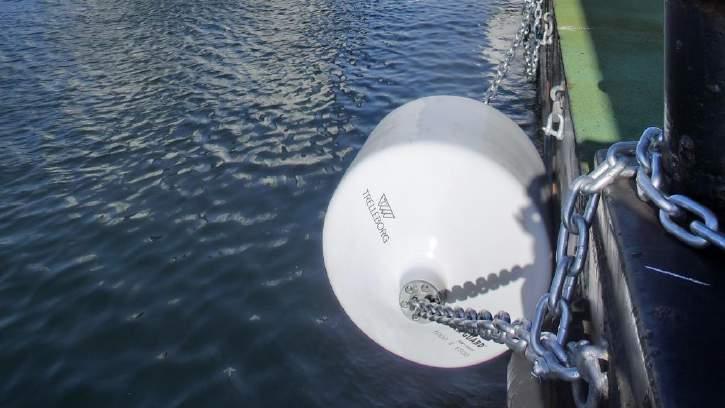
36 Second Berth Fenders

37 Second Berth Existing Dock Upgrades Mooring Upgrades
38 Second Berth Regulatory Approvals AUTHORITY REGULATION REQUIREMENT STATUS Department of Fisheries and Oceans (DFO) Transport Canada Transport Canada Transport Canada Fisheries Act FA Authorization Navigation Protection Act (NPA) Federal Real Property Regulations Federal Real Property Regulations NPA Authorization Waterlot Lease Agreement Dredge License Agreement Transport Canada/DFO CEAA 2012 Environmental Effects Determination (EED) signoff Nova Scotia Environment Nova Scotia Environment Act Amendment to Existing Part V Approval
39 Second Berth Next Steps PROJECT COMPONENT Geotechnical Program Marine (BH) & Landside (BH & TP) Environmental Sampling & Testing Detailed Engineering Design Regulatory Permits and Approvals STATUS Tender Period Construction Summer 2018 Commissioning/Operations Summer/Fall 2019
40 QUESTIONS
Department of National Defence B-Jetty Reconstruction
 Department of National Defence B-Jetty Reconstruction CFB Esquimalt, BC Presented by: Stantec & Golder Associates February 2, 2016 Agenda 1 B-Jetty Project Background 2 Distinguishing Project Features
FOUNDATION DESIGN AND CASE STUDIES
 The University of the West Indies Organization of American States PROFESSIONAL DEVELOPMENT PROGRAMME: COASTAL INFRASTRUCTURE DESIGN, CONSTRUCTION AND MAINTENANCE A COURSE IN DESIGN OF MARINE STRUCTURES
Geotechnical Investigation Juneau Seawalk - Taku Fisheries to Miner s Wharf Juneau, Alaska DM&A Job No
 Duane Miller & Associates 5821 Arctic Boulevard, Suite A Anchorage, AK 99518-1654 (907) 644-3200 Fax 644-0507 Arctic & Geotechnical Engineering May 4, 2006 Tetra Tech/KCM, Inc. 1971 First Avenue Seattle,
June 9, R. D. Cook, P.Eng. Soils Engineer Special Services Western Region PUBLIC WORKS CANADA WESTERN REGION REPORT ON
 PUBLIC WORKS CANADA WESTERN REGION REPORT ON GEOTECHNICAL INVESTIGATION PROPOSED MARTIN RIVER BRIDGE MILE 306.7 MACKENZIE HIGHWAY Submitted by : R. D. Cook, P.Eng. Soils Engineer Special Services Western
Horizontal Directional Drilling: An Approach to Design and Construction. Presenter: John Briand, PE Co-Author: Danielle Neamtu, PE
 Horizontal Directional Drilling: An Approach to Design and Construction Presenter: John Briand, PE Co-Author: Danielle Neamtu, PE Presentation Outline General HDD overview Conceptual-level evaluation Detailed
IN SITU SPECIFIC GRAVITY VS GRAIN SIZE: A BETTER METHOD TO ESTIMATE NEW WORK DREDGING PRODUCTION
 IN SITU SPECIFIC GRAVITY VS GRAIN SIZE: A BETTER METHOD TO ESTIMATE NEW WORK DREDGING PRODUCTION Nancy Case O Bourke, PE 1, Gregory L. Hartman, PE 2 and Paul Fuglevand, PE 3 ABSTRACT In-situ specific gravity
SITE INVESTIGATION 1
 SITE INVESTIGATION 1 Definition The process of determining the layers of natural soil deposits that will underlie a proposed structure and their physical properties is generally referred to as site investigation.
NCP3 NCP4 EXISTING CONDITIONS NOTES: RIP-RAP FAILED WALL SECTION NORTH WAREHOUSE CEMEX SILOS BULKHEAD WALL
 UGE UGE UGE UGE UGE UGE UGE N SCALE: " = 4 6 ' 445 CHALLENGER RD., SUITE () 799-6 () 799-8 (FA) SCALE: JOB # NOTED - P RIP-RAP CEME SILOS DOLPHIN RD. FAILED WALL SECTION NORTH WAREHOUSE BULKHEAD WALL NCP4
R.M.HARW & ASSOCIATES LTD. GEOTECHNICAL INVESTIGATION PROPOSED BRIDGE SITE. HELAVA CREEKl MILE MACKENZIE HIGHWAY E-2510 OCTOBER 16, 1973
 El R.M.HARW & ASSOCIATES LTD. GEOTECHNICAL INVESTIGATION PROPOSED BRIDGE SITE HELAVA CREEKl MILE 616.4 MACKENZIE HIGHWAY E-2510 OCTOBER 16, 1973 R,M,HARDV & ASSOCIATES LTD. CONSULTING ENGINEERING & TESTING
Highland Lake Bathymetric Survey
 Highland Lake Bathymetric Survey Final Report, Prepared For: The Town of Highland Lake 612 Lakeshore Drive Oneonta, AL 35121 Prepared By: Tetra Tech 2110 Powers Ferry Road SE Suite 202 Atlanta, GA 30339
ENCE 3610 Soil Mechanics. Site Exploration and Characterisation Field Exploration Methods
 ENCE 3610 Soil Mechanics Site Exploration and Characterisation Field Exploration Methods Geotechnical Involvement in Project Phases Planning Design Alternatives Preparation of Detailed Plans Final Design
Sediment and sedimentary rocks Sediment
 Sediment and sedimentary rocks Sediment From sediments to sedimentary rocks (transportation, deposition, preservation and lithification) Types of sedimentary rocks (clastic, chemical and organic) Sedimentary
 Page 1 of 9 Name: Base your answer to the question on the diagram below. The arrows show the direction in which sediment is being transported along the shoreline. A barrier beach has formed, creating a
4 Project Alternatives
 BSD Deepening EIR Page 50 4 Project Alternatives In terms of the EIA regulations (Regulation 6 (1) (d) GN No. R1183, dated 5 September 1997) and NEMA, the applicant is required to demonstrate that alternatives
Essential Questions. What is erosion? What is mass wasting?
 Erosion Essential Questions What is erosion? What is mass wasting? What is Erosion? Erosion The transportation of sediment from one area to another Caused mainly by running water but also caused by glaciers,
Subsurface Geology of the Kennebec River
 Maine Geologic Facts and Localities July, 1998 Subsurface Geology of the Kennebec River 43 54 40.75 N, 69 48 29.01 W Text by Daniel B. Locke, Department of Agriculture, Conservation & Forestry 1 Map by
Glacial Geology of Moose Point State Park, ME
 Geologic Site of the Month May, 2013 Glacial Geology of Moose Point State Park, Maine 44 o 25 59.18"N, 68 o 56 37.11"W Text and photos by Woodrow B. Thompson, Department of Agriculture, Conservation &
TECHNICAL SUPPORT DOCUMENT # 1 COMPARATIVE EVALUATION OF ALTERNATIVE SITES APPENDIX TSD#1-H. Design & Operations Component
 TECHNICAL SUPPORT DOCUMENT # 1 COMPARATIVE EVALUATION OF ALTERNATIVE SITES APPENDIX TSD#1-H Design & Operations Component February 2013 February 2013 Design & Operations Component Appendix TSD#1-H COMPARATIVE
ARCH 1250 APPLIED ENVIRONMENTAL STUDIES
 John Seitz, RA, LEED AP Assistant Adjunct Professor Professor Paul C. King, RA, AIA, ARA Assistant Professor Geology Geology is the scientific study of the structure and composition of the earth s surface
The Arctic - A New Frontier The geological, environmental and engineering challenges for submarine telecommunication cables
 The Arctic - A New Frontier The geological, environmental and engineering challenges for submarine telecommunication cables Ryan Wopschall 5 September 2013 Oceanology International China, Shanghai Fugro
Sunset Harbour / Huntington Harbour Maintenance Dredging and Waterline Installation Project. CMANC 21 January 2016
 Sunset Harbour / Huntington Harbour Maintenance Dredging and Waterline Installation Project CMANC 21 January 2016 County of Orange Footprint Huntington Harbour Operational and Dredging Cost Sharing Agreements
Annual transport rates at two locations on the fore-slope.
 Sediment Transport by Currents Fore-slope Sediment transport rates and sediment concentrations were computed from the hydrodynamic model runs as well as from direct measurements of current velocities at
SASKATCHEWAN STRATIGRAPHY GLACIAL EXAMPLE BOULDERS IN GLACIAL DEPOSITS
 SASKATCHEWAN STRATIGRAPHY GLACIAL EXAMPLE BOULDERS IN GLACIAL DEPOSITS 51 SASKATCHEWAN STRATIGRAPHY GLACIAL SURFICIAL STRATIFIED DEPOSITS 52 SASKATCHEWAN STRATIGRAPHY GLACIAL EXAMPLE OF SEDIMENT DEPOSITION
Connecticut's Aquifers
 Page 1 of 5 DEP Search: Connecticut's Aquifers The technical definition of the word "aquifer" is: any geologic formation capable of yielding significant quantities of water to wells. By that definition,
Hydro One (Sept 2014) Hydro One (Sept 2014) Hydro One (Sept 2014)
 Hydro One (Sept 2014) Hydro One (Sept 2014)") TABLE 1 WELL CONSTRUCTION DETAILS MOE WWR No Well ID Location Installation Date Status Easting Coordinates Northing Source Elevation Screened Interval Screened Material Borehole Well Stick-up Ground Top
TABLE 1 WELL CONSTRUCTION DETAILS MOE WWR No Well ID Location Installation Date Status Easting Coordinates Northing Source Elevation Screened Interval Screened Material Borehole Well Stick-up Ground Top
Chapter 5: Glaciers and Deserts
 I. Glaciers and Glaciation Chapter 5: Glaciers and Deserts A. A thick mass of ice that forms over land from the compaction and recrystallization of snow and shows evidence of past or present flow B. Types
Re: Steep Slope Assessment for 2465 Waverly Drive, Blind Bay, BC; Legal Address: Lot 39, Section 18, Township 22, Range 10, Plan 25579, W6M, KDYD.
 OEL File 1563-1 May 30, 2017 Doug Wall PO Box 774 Salmon Arm, BC V1E 4N7 Re: Steep Slope Assessment for 2465 Waverly Drive, Blind Bay, BC; Legal Address: Lot 39, Section 18, Township 22, Range 10, Plan
Proposed New Westridge Marine Terminal, Trans Mountain Expansion Project, Burnaby, BC, Canada
 Appendix F Golder Associates Geotechnical Factual Report on Westridge Marine Terminal Offshore Geotechnical Investigations, December 23, 2016 23 December 2016 GEOTECHNICAL FACTUAL REPORT ON WESTRIDGE MARINE
How to Identify and Properly Classify Drill Cuttings
 How to Identify and Properly Classify Drill Cuttings (Creating Useful Borehole Logs) Dave Larson Hydrogeology and Geophysics Section Accurate information about the borehole location and a careful description
R. D. Cook. February 2, 1976 PUBLIC WORKS CANADA WESTERN REGION SUPPLEMENTARY REPORT FOUNDATION INVESTIGATION
 ".. 00010 PUBLC WORKS CANADA WESTERN REGON c SUPPLEMENTARY REPORT FOUNDATON NVESTGATON PROPOSED WHTESAND CREEK BRDGE MLE 459.6, MACKENZE HGHWAY Submitted By R. D. Cook Soils Engineer Special Services Western
Proposed New Westridge Marine Terminal, Trans Mountain Expansion Project, Burnaby, BC, Canada
 Appendix F Golder Associates Geotechnical Factual Report on Westridge Marine Terminal Offshore Geotechnical Investigations, December 23, 2016 GEOTECHNICAL FACTUAL REPORT ON WESTRIDGE MARINE TERMINAL OFFSHORE
Hydrogeological Assessment for Part of Lots 2 and 3, Concession 5, Township of Thurlow, County of Hastings 1.0 INTRODUCTION. 1.
 February 10,2017 25506400 Ontario Ltd. Foxboro, ON Attention: Brad Newbatt Re: Hydrogeological Assessment for Part of Lots 2 and 3, Concession 5, Township of Thurlow, County of Hastings 1.0 INTRODUCTION
Depth (ft) USCS Soil Description TOPSOIL & FOREST DUFF
 USCS Soil Description TOPSOIL & FOREST DUFF") Test Pit No. TP-6 Location: Latitude 47.543003, Longitude -121.980441 Approximate Ground Surface Elevation: 1,132 feet Depth (ft) USCS Soil Description 0 1.5 1.5 5.0 SM 5.0 8.0 SM Loose to medium dense,
Test Pit No. TP-6 Location: Latitude 47.543003, Longitude -121.980441 Approximate Ground Surface Elevation: 1,132 feet Depth (ft) USCS Soil Description 0 1.5 1.5 5.0 SM 5.0 8.0 SM Loose to medium dense,
Module 1 : Site Exploration and Geotechnical Investigation
 Objectives In this section you will learn the following Displacement borings Wash boring Auger boring Rotary drilling Percussion drilling Continuous sampling Boring methods of exploration The boring methods
Redwood City Harbor, California, Navigation Improvement Feasibility Study. Appendix D. Geotechnical Engineering. DRAFT April 2015
 1 Redwood City Harbor, California, Navigation Improvement Feasibility Study Appendix D Geotechnical Engineering DRAFT April 2015 2 Contents 1 Purposes of Report... 3 2 Background... 3 3 References and
Lecture Outline Wednesday - Friday February 14-16, 2018
 Lecture Outline Wednesday - Friday February 14-16, 2018 Quiz 2 scheduled for Friday Feb 23 (Interlude B, Chapters 6,7) Questions? Chapter 6 Pages of the Past: Sedimentary Rocks Key Points for today Be
Marine Sediments. Introductory Oceanography. Ray Rector: Instructor
 Marine Sediments Introductory Oceanography Ray Rector: Instructor Ocean Basins are Vast Sinks for Huge Amounts of Sediment from Numerous Different Sources Four Major Types of Seafloor Sediments 1. Lithogenous
Annex B. Engineering & Planning Information Requirements
 Annex B Engineering & Planning Information Requirements Project Memo 21 August 2008 TO: Zoë Day FROM: Ellen Campbell cc: Ken Russell KR HMG JV Alan Wijnberg AW PRDW Justin Cross JC PRDW Kenneth Pederson
Sedimentary Rocks. Weathering. Mechanical & Chemical Weathering. Sediments. Lithification. Deposition. Transport. Erosion.
 Lithification Sedimentary Rocks Sediments Deposition Transport Erosion Weathering Weathering The sediments that make up sedimentary rocks are produced by: Mechanical & Chemical Weathering Mechanical Weathering
June 2018 Sediments and Dredging at GBR Ports
 June 2018 Sediments and Dredging at GBR Ports Reef 2050 Long Term Sustainability Plan The Great Barrier Reef is over 2000 km long and covers an area of approximately 350,000 square kilometres. It is a
SEDIMENTARY ROCKS FROM THE CONTINENTAL SHELF AND SLOPE OFF THE CENTRAL COAST OF OREGON. By Neil J. Maloney and John V. Byrne
 SEDMENTARY ROCKS FROM THE CONTNENTAL SHELF AND SLOPE OFF THE CENTRAL COAST OF OREGON By Neil J. Maloney and John V. Byrne Reprinted from: The ORE BN, vol. 26, no. 5, May 1964 Oregon Department of Geology
Closure of Remote Historic Underground Mines in Desert Environments
 Closure of Remote Historic Underground Mines in Desert Environments James A. Cremeens Agapito Associates, Inc. Michael H. Rauschkolb U.S. Borax, Inc. 2002 SME Annual Meeting and Exhibit Geotechnical solutions
J. Paul Guyer, P.E., R.A.
 J. Paul Guyer, P.E., R.A. Paul Guyer is a registered mechanical engineer, civil engineer, fire protection engineer and architect with over 35 years experience in the design of buildings and related infrastructure.
1. Base your answer to the following question on the map below, which shows the generalized bedrock of a part of western New York State.
 1. Base your answer to the following question on the map below, which shows the generalized bedrock of a part of western New York State. 3. The table below describes the deposits that an observer saw while
As compaction and cementation of these sediments eventually occur, which area will become siltstone? A) A B) B C) C D) D
 A B) B C) C D) D") 1. A student obtains a cup of quartz sand from a beach. A saltwater solution is poured into the sand and allowed to evaporate. The mineral residue from the saltwater solution cements the sand grains together,
1. A student obtains a cup of quartz sand from a beach. A saltwater solution is poured into the sand and allowed to evaporate. The mineral residue from the saltwater solution cements the sand grains together,
UNIT 4 SEDIMENTARY ROCKS
 UNIT 4 SEDIMENTARY ROCKS WHAT ARE SEDIMENTS Sediments are loose Earth materials (unconsolidated materials) such as sand which are transported by the action of water, wind, glacial ice and gravity. These
Lesson 25. Static Pile Load Testing, O-cell, and Statnamic. Reference Manual Chapter 18
 Lesson 25 Static Pile Load Testing, O-cell, and Statnamic Reference Manual Chapter 18 STATIC LOAD TESTING Most accurate method to determine static pile capacity Perform at design or construction stage
Objectives: Define Relative Age, Absolute Age
 S6E5. Students will investigate the scientific view of how the earth s surface is formed. c. Classify rocks by their process of formation. g. Describe how fossils show evidence of the changing surface
1. Any process that causes rock to crack or break into pieces is called physical weathering. Initial product = final product
 Weathering 1. Any process that causes rock to crack or break into pieces is called physical weathering. Initial product = final product End Result of physical weathering is increased surface area. 2. Physical
IAEA SAFETY STANDARDS Geotechnical Aspects of Site Evaluation and Foundations in NPPs, NS-G-3.6
 IAEA SAFETY STANDARDS Geotechnical Aspects of Site Evaluation and Foundations in NPPs, NS-G-3.6 Regional Workshop on Volcanic, Seismic, and Tsunami Hazard Assessment Related to NPP Siting Activities and
APPENDIX C 6 WHARF DEVELOPMENT 3D GEOLOGICAL MODEL AND DREDGE VOLUMES
 APPENDIX C WHARF DEVELOPMENT 3D GEOLOGICAL MODEL AND DREDGE VOLUMES Report Wharf Development: 3D Geological Model and Dredge Volumes Prepared for Napier Port Prepared by (Beca) 1 May 17 1//17 Wharf Development:
Sediment and Sedimentary rock
 Sediment and Sedimentary rock Sediment: An accumulation of loose mineral grains, such as boulders, pebbles, sand, silt or mud, which are not cemented together. Mechanical and chemical weathering produces
REPORT OF PRELIMINARY GEOTECHNICAL EXPLORATION
 REPORT OF PRELIMINARY GEOTECHNICAL EXPLORATION ENKA INTERMEDIATE SCHOOL Sand Hill Road Candler, North Carolina Prepared For: BUNCOMBE COUNTY SCHOOLS Prepared By: AMEC ENVIRONMENT & INFRASTRUCTURE, INC.
Marine Mammal Observer Report
 Marine Mammal Observer Report Project: Maintenance Dredging, Dublin Port Marine Mammal Observers Report for Dredging and Dumping Activity June-July 2016 Client: Dublin Port Company Foreshore License: AKC/2016/00262
Geotechnical Engineering Report
 Geotechnical Engineering Report Turner Turnpike Widening Polecat Creek Bridge (Bridge A) June 1, 2016 Terracon Project No. 04155197 Prepared for: Garver, LLC Prepared by: Terracon Consultants, Inc. TABLE
Proposed Cemetery Thornhill Road. Tier One Hydrogeological Risk Assessment. Peter Mitchell Associates
 Proposed Cemetery Thornhill Road Tier One Hydrogeological Risk Assessment Peter Mitchell Associates January 2015 Executive Summary This report uses a desk-based risk assessment technique published by the
Which particle of quartz shows evidence of being transported the farthest distance by the stream? A) B) C) D)
 B) C) D)") 1. Base your answer to the following question on the block diagram below, which represents the landscape features associated with a meandering stream. WX is the location of a cross section. Location A
1. Base your answer to the following question on the block diagram below, which represents the landscape features associated with a meandering stream. WX is the location of a cross section. Location A
Sedimentary Rocks. All sedimentary rocks begin to form when existing rocks are broken down into sediments Sediments are mainly weathered debris
 Rocks! Objectives Describe the major processes involved in the formation of sedimentary rock Distinguish between clastic sedimentary rocks and chemical sedimentary rocks Identify the features that are
TINTAGEL CASTLE FOOTBRIDGE OPTIONS APPRAISAL. Feasibility Report July 2014
 TINTAGEL CASTLE FOOTBRIDGE OPTIONS APPRAISAL Feasibility Report July 2014 THE SETTING LOCATION Proposed alignment of bridge 09 ALIGNMENT 01 03 02 04 05 07 09 Key 1. Lower Mainland Courtyard 06 2. Existing
Review of Geotechnical and Archaeological Conditions at the Money Pit ( ) Oak Island, Nova Scotia
 Oak Island, Nova Scotia") Review of Geotechnical and Archaeological Conditions at the Money Pit (1967 2005) Oak Island, Nova Scotia Money Pit Presentation By Les MacPhie August 13, 2005 Geotechnical and Archaeological Conditions
Review of Geotechnical and Archaeological Conditions at the Money Pit (1967 2005) Oak Island, Nova Scotia Money Pit Presentation By Les MacPhie August 13, 2005 Geotechnical and Archaeological Conditions
A Sedimentary Rock is..
 Sedimentary Rocks A Sedimentary Rock is.. rock formed from the lithification or crystallization of: 1. Minerals in solution 2. Organic remains 3. Materials produced by living things (biochemical) 4. Clastic
UAS Student Residence
 General Notes, Abbreviations and Symbols C100 MATCH LINE - SEE SHEET L6 Existing Site Topographic Conditions C101 MATCH LINE - SEE SHEET L5 Existing Site Topographic Conditions C102 DEPTH(FT.) 5 FROZEN
Objectives. Introduction to Soils. Terms to know: What is soil? Study of Soils. The Soil Body 11/9/2012
 Objectives Explain what soil is and where it comes from Define a soil body List examples of the five soil-forming factors Explain how soils develop Introduction to Soils Terms to know: What is soil? Alluvial
Exploitation of Ocean Predictions by the Oil and Gas Industry. GODAE OceanView Symposium 2013
 Exploitation of Ocean Predictions by the Oil and Gas Industry GODAE OceanView Symposium 2013 Introduction Information needs Challenges Acknowledgements IMarEST/SUT Metocean Awareness Course Colleagues
Name. 4. The diagram below shows a soil profile formed in an area of granite bedrock. Four different soil horizons, A, B, C, and D, are shown.
 Name 1. In the cross section of the hill shown below, which rock units are probably most resistant to weathering? 4. The diagram below shows a soil profile formed in an area of granite bedrock. Four different
THE ACTION OF GLACIERS
 Surface processes THE ACTION OF GLACIERS Glaciers are enormous masses of ice which are formed due to accumulation, compaction and re-crystallisation of the snow deposited in very cold regions (the majority
Run 028 (Note: error in UKC at start of exercise due incorrect tide input then corrected ok.)
") Run 027 RNZ Full Bridge Simulation Run Plots Final Report Be-Software August 2016 Prepared for Royal Haskoning DHV on behalf of Refining New Zealand Limited 27 Run 028 (Note: error in UKC at start of exercise
Run 027 RNZ Full Bridge Simulation Run Plots Final Report Be-Software August 2016 Prepared for Royal Haskoning DHV on behalf of Refining New Zealand Limited 27 Run 028 (Note: error in UKC at start of exercise
Figure 1 The map shows the top view of a meandering stream as it enters a lake. At which points along the stream are erosion and deposition dominant?
 1. In which type of climate does chemical weathering usually occur most rapidly? 1. hot and dry 3. cold and dry 2. hot and wet 4. cold and wet 2. Figure 1 The map shows the top view of a meandering stream
GEOLOGY OF TODMORDEN MOOR 2 BACKGROUND
 GEOLOGY OF TODMORDEN MOOR 2 BACKGROUND 1) THE CARBONIFEROUS SERIES OF ROCKS The rocks of the Todmorden district are of the Carboniferous Series and were first laid down in an ancient sea, which covered
Resistivity & IP methods
 International PhD Course in HYDROGEOPHYSICS Resistivity & IP methods Andrew Binley Lancaster University Overview We have demonstrated links between hydrological and geophysical properties and show the
Sedimentary Rocks. Origin, Properties and Identification. Geology Laboratory GEOL 101 Lab Ray Rector - Instructor
 Sedimentary Rocks Origin, Properties and Identification Geology Laboratory GEOL 101 Lab Ray Rector - Instructor Sedimentary Rock Origin and Identification Lab Pre-Lab Internet Link Resources 1) http://www.rockhounds.com/rockshop/rockkey/index.html
Soil Mechanics. Chapter # 1. Prepared By Mr. Ashok Kumar Lecturer in Civil Engineering Gpes Meham Rohtak INTRODUCTION TO SOIL MECHANICS AND ITS TYPES
 Soil Mechanics Chapter # 1 INTRODUCTION TO SOIL MECHANICS AND ITS TYPES Prepared By Mr. Ashok Kumar Lecturer in Civil Engineering Gpes Meham Rohtak Chapter Outlines Introduction to Soil Mechanics, Soil
Inspection of Waterfront Facilities Using Vessel-Based Remote Sensing Mitchell, Del Bello, Suarez
 Inspection of Waterfront Facilities Using Vessel-Based Remote Sensing Mitchell, Del Bello, Suarez American Association of Port Authorities Facilities Engineering Conference October 20-22, 2015 Waterfront
Surface Water and Stream Development
 Surface Water and Stream Development Surface Water The moment a raindrop falls to earth it begins its return to the sea. Once water reaches Earth s surface it may evaporate back into the atmosphere, soak
3.18 GEOLOGY AND SOILS
 3.18 GEOLOGY AND SOILS This section discusses geologic resource concerns as they relate to the environment, public safety, and project design both during construction and after completion of the project.
Harmonized European standards for construction in Egypt
 Harmonized European standards for construction in Egypt EN 1998 - Design of structures for earthquake resistance Jean-Armand Calgaro Chairman of CEN/TC250 Organised with the support of the Egyptian Organization
Understanding Earth Fifth Edition
 Understanding Earth Fifth Edition Grotzinger Jordan Press Siever Chapter 5: SEDIMENTATION: Rocks Formed by Surface Processes Lecturer: H Mohammadzadeh Assistant professors, Department of Geology, FUM Copyright
EXTENSION OF A HOTEL IN POIANA BRASOV ON AN INCLINED SLOPE
 Bulletin of the Transilvania University of Braşov Vol. 9 (58) - 2016 Series I: Engineering Sciences EXTENSION OF A HOTEL IN POIANA BRASOV ON AN INCLINED SLOPE M. MĂNTULESCU 1 I. TUNS 2 Abstract: Extension
Page 1. Name:
 Name: 1) Which event is the best example of erosion? dissolving of rock particles on a limestone gravestone by acid rain breaking apart of shale as a result of water freezing in a crack rolling of a pebble
The Coast: Beaches and Shoreline Processes
 1 2 3 4 5 6 7 8 9 The Coast: es and Shoreline Processes Trujillo & Thurman, Chapter 10 Oceanography 101 Chapter Objectives Recognize the various landforms characteristic of beaches and coastal regions.
Lab 7: Sedimentary Structures
 Name: Lab 7: Sedimentary Structures Sedimentary rocks account for a negligibly small fraction of Earth s mass, yet they are commonly encountered because the processes that form them are ubiquitous in the
Background. Valley fills Sites in the Area. Construction over Mine Spoil Fills
 Construction over Mine Spoil Fills Wayne A. Karem, PhD, PE, PG, D.GE 2014 KSPE Annual Conference Background Strip mining; mountaintop and contour mining Creates huge quantities of mine spoil The mine spoil
HW #2 Landscape Travel from A to B 12,
 HW #2 Landscape 2016 Section: Name: ate: 1. ase your answer(s) to the following question(s) on the map below, which represents two bridges that cross the Green River. Letters,, and represent locations
The Coast: Beaches and Shoreline Processes Trujillo & Thurman, Chapter 10
 The Coast: es and Shoreline Processes Trujillo & Thurman, Chapter 10 Oceanography 101 Chapter Objectives Recognize the various landforms characteristic of beaches and coastal regions. Identify seasonal
MASS MOVEMENTS, WIND, AND GLACIERS
 Date Period Name MASS MOVEMENTS, WIND, AND GLACIERS SECTION.1 Mass Movements In your textbook, read about mass movements. Use each of the terms below just once to complete the passage. avalanche creep
Lecture Outlines PowerPoint. Chapter 6 Earth Science 11e Tarbuck/Lutgens
 Lecture Outlines PowerPoint Chapter 6 Earth Science 11e Tarbuck/Lutgens 2006 Pearson Prentice Hall This work is protected by United States copyright laws and is provided solely for the use of instructors
Section 5 Source Water Protection
 2017 WSP UPDATE Section 5 Source Water Protection As written in WAC 246-290-135, -668, and -690, Group A water systems are required to have source water protection. Source water protection is accomplished
Fish Passage at Road Crossings
 Fish Passage at Road Crossings 1 Crossing Design Workshop Outline 1:00 to 2:00 Intro, Design Overview, Channel Width 2:00 to 2:15 Break 2:15 to 3:15 No-Slope, Stream Simulation Design 3:15 to 3:30 Break
Introduction to Prospecting. Session Two Geology
 Introduction to Prospecting Session Two Geology The Earth Earth is 4.6 billion years old (Ba). Bacteria & algae +3.5 Ba. Microscopic animals ~2 Ba. Animals ~600 million years (Ma) old. Mankind about 100,000
Saving on the Geotechnical Investigation A False Economy
 Saving on the Geotechnical Investigation A False Economy G. S. Young 1, BE, MEngSc, FIEAust and W. Ellis 2. 1 Douglas Partners Pty Ltd, 96 Hermitage Road, West Ryde, NSW 2114 PH (02) 9809 0666; email:
East Land Quality Forum Drilling Techniques; Old and New
 East Land Quality Forum Drilling Techniques; Old and New 1 Introduction Different Drilling Methods Rota-sonic drilling What is it and how does it work? Different types of Rota-Sonic/Sonic Drilling Rigs
GEOTECHNICAL REPORT CBSA Facility Redevelopment Thousand Islands International Crossing Lansdowne, Ontario
 GEOTECHNICAL REPORT CBSA Facility Redevelopment Thousand Islands International Crossing Lansdowne, Ontario Prepared For: The Federal Bridge Corporation Limited SPL Project No.: 10001084 Report Date: January
Marine Geophysical Methods: What Can and Cannot Be Done to Iden8fy Hazards to Dredging & Marine Construc8on
 Marine Geophysical Methods: What Can and Cannot Be Done to Iden8fy Hazards to Dredging & Marine Construc8on Marine Geophysics Sham or Savior? Seen alternatively as the silver bullet or snake oil, marine
Geophysics for Environmental and Geotechnical Applications
 Geophysics for Environmental and Geotechnical Applications Dr. Katherine Grote University of Wisconsin Eau Claire Why Use Geophysics? Improve the quality of site characterization (higher resolution and
The East of Nantucket Survey. Preliminary Results Presented by Eric Powell to the Habitat PDT on September 14, 2017
 The East of Nantucket Survey Preliminary Results Presented by Eric Powell to the Habitat PDT on September 14, 2017 Thanks Roger Mann who handled the logistics of the cruise Tom Dameron and others who provided
A6 to Manchester Airport Relief Road. B003 Mill Lane Accommodation Bridge Preliminary Design Report Report No. 1007/704/151
 A6 to Manchester Airport Relief Road B003 Mill Lane Accommodation Bridge Report No. 1007/704/151 August 2013 PRELIMINARY DESIGN REPORT Structure Name : Structure Number : Mill Lane Accommodation Bridge
R.SUNDARAVADIVELU Professor IIT Madras,Chennai - 36.
 Behaviour of Berthing Structure under Changing Slope in Seismic Condition - A Case Study K.MUTHUKKUMARAN Research Scholar Department of Ocean Engineering, R.SUNDARAVADIVELU Professor IIT Madras,Chennai
Seagrass Transplantation & Environmental & Marine Consulting Services, Inc. Drew Campbell, Vice President & Lead Scientst.
 Indian River Lagoon Symposium Seagrass Transplantation & Project Considerations Environmental & Marine Consulting Services, Inc. Drew Campbell, Vice President & Lead Scientst March 26 th, 2013 Regulatory
2 Aggregates in Indiana
 2 Aggregates in Indiana Origin of Aggregates Gravel and Natural Sands Crushed Stone Slag Distribution of Aggregates Glacial Deposits Bedrock Deposits Aggregate Types Natural Aggregates Artificial Aggregates