Hydraulic Structures. Notes and Handouts
|
|
|
- Simon Hampton
- 5 years ago
- Views:
Transcription
1 Hydraulic Structures Notes and Handouts
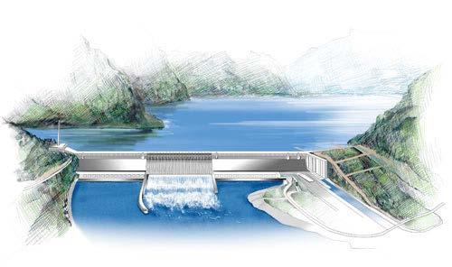
2 Introduction Free surface flows in particular often have hydraulic structures to control flow Dams Spillways Stilling Basins Weirs Gates Can have hydraulic/structural/geotechnical aspects
3 Purposes of Structures 1. Storage Structures (Reservoir) 2. Conveyance (Culvert) 3. Waterway and Navigation (Navigational Canal) 4. Coastal (Breakwater, Jetties) 5. Measurement and Control (Sharp-edged weir) 6. Energy-Conversion (Hydroelectric Dam and Turbines) 7. Sediment & Fish Control Structures (Fish Weir) 8. Energy-Dissipation (Stilling Basin) 9. Collection (Surface Drainage Inlet)
 Flood control Impoundment (drinking water, electricity, navigation) Diversion")
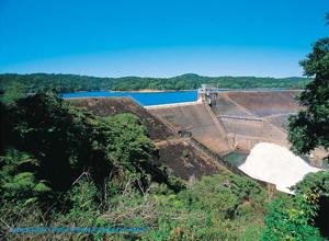
4 Dams More than 79,000 significant dams in US (over 25ft high, 50 acre-feet or dangerous) Indiana 1047 many are old (>100 years) Flood control Impoundment (drinking water, electricity, navigation) Diversion (irrigation)
 Stone (480) Timber Crib (257) Other (1044) Oroville Dam (California) 754")
5 Types of Dams in US Earthfill (72,300+ of 79,000) Rockfill (2366) Concrete (2392) Masonry (761) Stone (480) Timber Crib (257) Other (1044) Oroville Dam (California) 754 ft high


6 Earthfill Dams

7 Earthfill Dams By far most common type of dam - Trapezoidal profile Levee is also type of earthfill dam Homogeneous or with more impermeable core Careful about seepage Oldest construction type - Use local materials Avoid Sudden Drawdown Should never be overtopped Separate spillways
8
9


10 Grand Teton Dam Failure


11 Concrete Gravity Dams Remains stable through gravitational forces Usually in narrow cross-sections Careful of foundation for high head Common for hydroelectric plants
12 Gravity Dam Stability Need to make sure that concrete gravity dams stay in place Resistance to sliding FS Resistance to overturning about toe FS 2 All soil pressures on dam must be positive Negative pressures lead to high pressure intrusions instability Earthquakes can provide additional loading in seismically active areas
13 F Fr F R Hydrostatic Force, F HS Weight, W Fluid Uplift on Dam Base, F u Sedimentation, F s Earthquake on Dam, F EQ (any direction) Earthquake on Water, F EW (horizontal) Friction at Base, F Fr Soil Vertical Force, F R Example
14 Dam Soil Pressures After other weights and moments are summed, the magnitude, direction, and location of resultant soil force are just what is left over to sum to zero First approximation: trapezoidal force along base To avoid negative soil pressures, need to make sure resultant is in the middle 1/3 of base


15 Arch Dams Volume of gravity, earthfill dams increases strongly with height In narrow valley with strong side walls, build narrow arch dams Walls take arch thrust and resist overturning More economical use of materials Need good foundation
16 Arch Dam Stresses Arch dams have normal stresses against a curved surface Arch stresses usually larger than vertical compressive stresses Hoop stress depends on dam radius Optimization for total amount of concrete used in arch dam Minimum amount for arc to span gap
17 Flow Under Dams Dams combine large changes in head with short distances for groundwater to travel Potential for high gradients of porewater pressure Piping leads to catastrophic failure Extremely careful geotechnical investigation needed for dams even for rock Improvements grout to reduce permeability plus drainage curtain The narrower the dam, the greater the potential for failure arch dams must have good geotechnical aspects


18 Use of Grout Curtains Images from Grouters.org
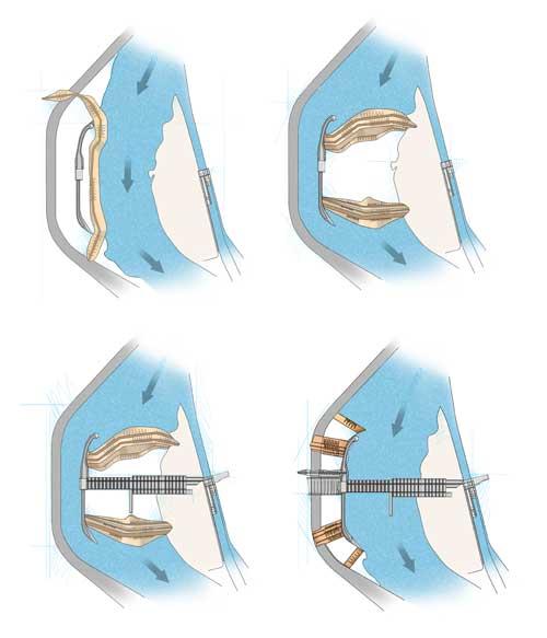
19 Dam Construction Stages 1. Divert water from construction site Tunnel, Channel 2. Cofferdam (upstream and downstream) to seal off work area 3. Foundation work and build dam 4. Close diversion, remove cofferdam Details vary greatly depending on circumstances
20


21 Diversion tunnel construction Cofferdam construction Construction in blocks Concrete lined tunnel
22 Dam Benefits/Adverse Effects Benefits Flood control Water supply Power Navigation Recreation Adverse Effects Resettlement Fish habitat/spawning Sediment impoundment Downstream erosion Temperature changes Loss of flooding cycles Maintenance/End of life issues
23 Dam Effects on Long-Term River Valley Landforms How do civil engineering activities affect long term processes? Widespread stream damming for power in pre-steam engine days In Pennsylvania, approx 0.15 dams/km 2 What effect does this have, even when old dams are gone?
 on Piedmont streams in York, Lancaster, and Chester counties, southeastern Pennsylvania, located from >100")
24 Fig. 2. Historic 19th-century milldams (triangles) on Piedmont streams in York, Lancaster, and Chester counties, southeastern Pennsylvania, located from >100 large-scale township maps dating to 1876 (York), 1875 (Lancaster), and 1847 (Chester). R C Walter, D J Merritts Science 2008;319: Published by AAAS
25 Effect of Damming a Valley Upstream of dam, water in millpond/reservoir becomes much slower Sediment load carried by stream/river tends to be deposited in slower water Over time (decades to centuries), sediment builds up in reservoir, increasing the bed elevation Smaller dams <10 acre/ft, typical ~3% per year loss of storage Stream bed becomes near-level with time upstream of dam

26 Fig. 3. Streams throughout the mid-atlantic region R C Walter, D J Merritts Science 2008;319: Published by AAAS

27
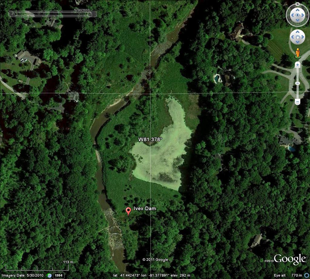
28 Sequence of Fill Original stream valley Dammed valley delta of coarse-grained material at beginning of pond, finer grained material throughout pond Gradual siltation to marsh Final conversion to valley meadows, occasionally flooded Often quickened by other human activities: agriculture, deforestation leading to larger sediment loads

29 Fig. 4. Methods for locating dams and assessing their impact on reservoir sedimentation, subsequent channel incision, and bank erosion with high-resolution LIDAR. Ground Elevation Existing Dam Stream Elevation Removed Dam Original Stream R C Walter, D J Merritts Science 2008;319: Published by AAAS

30 Beaver Dams Perform Similarly

31 Gradually Filling in the Valley

32 Leading to Beaver Meadows
33 Dam Removal Remove a dam, instantly change water levels Stream/river valley erodes downward through millpond sediments Steep banks, often near-vertical Gradual stream channel widening as pond sediments erode How long will it take to return to original state? Centuries, or never? Should it return to the original state? What was the original state?
34 Decisions for Dam Removal Net Benefit: Benefits minus costs (financial and operational) Costs Loss of hydropower/navigation Loss of flood control/impoundment/recreation Disruption to existing roads/houses/infrastructure Increased downstream sediment load Large financial outlay: Who Pays can be many millions of dollars!
35 Benefits for Dam Removal Increased downstream sediment loads More pronounced high/low flow cycles Removes chance of sudden failure for poorly maintained dams Water temperature changes Generally shows ecological improvements Fish passage and spawning Usually increased biodiversity
36 Implications 1. Civil and Environmental Engineering activities have effects that will last for centuries 2. What appears to be a natural state may actually have been created by humans, and may not be sustainable, or in equilibrium 3. This process also occurs in larger dams and reservoirs, with expensive consequences
37 Dam Failures Why do dams fail? Overtopping ~34% Foundation Defects ~30% Piping and Seepage ~20% Conduits and Valves ~10% Flow path beside conduit Other ~6% Includes human error What are the consequences? What can be done to prevent this? Examine case studies of dam failure
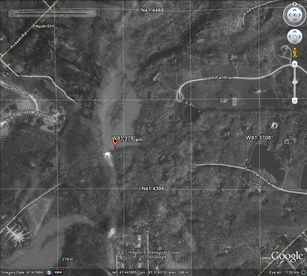
38 IVEX Dam Failure, Ohio Dam first constructed 1842 for hydropower Partially or completely failed five times 7.4m high Catastrophic Failure August 13, year rainfall event Reservoir emptied in 2-3 minutes Large flood wave downstream Peak discharge ~500m 3 /s Not likely for such a small stream in the absence of dam failure
39 Site Characteristics Chagrin River Ohio Mean flow downstream of dam ~400cfs (~11 m 3 /s) Overall slope 3m/km (0.003 slope) Sand and gravel banks and bed, fine material transported through system
40 Dam History Dam First Constructed in 1842, unanchored Failed immediately as toppling failure Rebuilt as earth dam with masonry spillway Failed completely in 1877 Rebuilt 1890 Partial failures in 1913, 1985 Seepage piping at spillway-dam contact Now used for water supply Spillway could not pass the Probable Maximum Flood of 1640m 3 /s
41
42 Dam Failure August 13, 1994, 13.5cm (5.3 inches) rainfall in 24 hours 70 year event Flows 1.9m above base of spillway Active gullying on downstream toe of dam from seepage piping Led to catastrophic failure widening gap between masonry spillway and dam May have been worse because of trees on dam

43 h
44
45 Failure Characteristics Estimated 466m 3 /s (16,500ft 3 /s) flow through dam 7.5m high breach, 15m wide Wide debris fan 1km downstream 1.5m over bankfull depth Strong erosional damage Road inundated 24,000-31,000m 3 of fine sediment swept downstream Downstream millpond filled in over years
46 Reservoir Sedimentation Initial storage capacity 274,000m 3 Reduced by 86%, 0.62%/year More than 2.6m sedimentation in some areas of reservoir
47 Lessons Design not adequate Spillway capacity, spillway-earth dam junction Built a century ago without engineering design Poor maintenance Trees growing on dam Introduces path along roots for water to travel Partial previous failures patched but not rebuilt No one seemed to pay attention to the dam

48 Testalinden Dam Failure Built in 1930s British Columbia for water storage and irrigation Privately owned Failed June 13, 2010 Large debris and mud torrent impacting homes and agricultural areas
49 History Built 1937 to store snowpack water in drier months Outlet culvert, spillway Seepage at outlet culvert noted in : road built across dam, spillway filled in with culvert under road 1961: spillway culvert not adequate for design flood 1977: Engineer s report dam condition deplorable, should be removed or rebuilt 1978 Dam is a hazard to life and property Continued problems 1980, 1985, 1988, 1992 report minimal freeboard, poor condition, spillway culvert was covered by rock slab
50 Failure June 11 (2 days before failure) Hiker noticed lake full and water flowing across the road. 12 inch channel across roadway Reported to Local Tourist Information Tourist information called police Technician only considered possible road washout, not dam failure not important road so nothing done
51 Failure June 13, 2010 Locals noticed dam was failing Everyone evacuated Large debris torrent flooded houses and farms, destroyed property No one injured


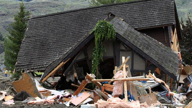
52 Before After After After
53 Why did this happen? Little to no engineering design of dam Poor capacity to convey large quantities of water Poor maintenance (covering culvert with rock slab) No remediation of known problems No clear path of accountability for dam safety hiker s warning not fully acted upon
Modeling Great Britain s Flood Defenses. Flood Defense in Great Britain. By Dr. Yizhong Qu
 Modeling Great Britain s Flood Defenses AIRCurrents Editor s note: AIR launched its Inland Flood Model for Great Britain in December 2008. The hazard module captures the physical processes of rainfall-runoff
Open Channel Flow Part 2. Ch 10 Young, notes, handouts
 Open Channel Flow Part 2 Ch 10 Young, notes, handouts Uniform Channel Flow Many situations have a good approximation d(v,y,q)/dx=0 Uniform flow Look at extended Bernoulli equation Friction slope exactly
Why Geomorphology for Fish Passage
 Channel Morphology - Stream Crossing Interactions An Overview Michael Love Michael Love & Associates mlove@h2odesigns.com (707) 476-8938 Why Geomorphology for Fish Passage 1. Understand the Scale of the
Lecture Note for Open Channel Hydraulics
 Chapter -one Introduction to Open Channel Hydraulics 1.1 Definitions Simply stated, Open channel flow is a flow of liquid in a conduit with free space. Open channel flow is particularly applied to understand
Strategies for managing sediment in dams. Iwona Conlan Consultant to IKMP, MRCS
 Strategies for managing sediment in dams Iwona Conlan Consultant to IKMP, MRCS 1 Sediment trapping by dams Active storage capacity Dead storage coarse material (bed load) Fine materials (suspension) Francis
UGRC 144 Science and Technology in Our Lives/Geohazards
 UGRC 144 Science and Technology in Our Lives/Geohazards Flood and Flood Hazards Dr. Patrick Asamoah Sakyi Department of Earth Science, UG, Legon College of Education School of Continuing and Distance Education
11/12/2014. Running Water. Introduction. Water on Earth. The Hydrologic Cycle. Fluid Flow
 Introduction Mercury, Venus, Earth and Mars share a similar history, but Earth is the only terrestrial planet with abundant water! Mercury is too small and hot Venus has a runaway green house effect so
Practical aspects of dam break analysis
 Practical aspects of dam break analysis Louis C Hattingh Hattingh Anderson Associates CC Dam break analysis It is a model You need to understand what you model & have an idea of the answers that you expect
CASE STUDY NATHPA JHAKRI, INDIA
 SEDIMENT MANAGEMENT CASE STUDY NATHPA JHAKRI, INDIA Key project features Name: Nathpa Jhakri Country: India Category: reduce sediment production (watershed management); upstream sediment trapping; bypass
Floods Lecture #21 20
 Floods 20 Lecture #21 What Is a Flood? Def: high discharge event along a river! Due to heavy rain or snow-melt During a flood, a river:! Erodes channel o Deeper & wider! Overflows channel o Deposits sediment
Earth Science Chapter 6 Section 2 Review
 Name: Class: Date: Earth Science Chapter 6 Section Review Multiple Choice Identify the choice that best completes the statement or answers the question. 1. Most streams carry the largest part of their
CCR Rule Annual Inspection Report (cont.) 2
 2") The inspection findings consisted of maintenance items and items that were not observed to be signs or potential signs of significant structural weakness. No deficiencies or disrupting conditions that
The inspection findings consisted of maintenance items and items that were not observed to be signs or potential signs of significant structural weakness. No deficiencies or disrupting conditions that
GEOL 1121 Earth Processes and Environments
 GEOL 1121 Earth Processes and Environments Wondwosen Seyoum Department of Geology University of Georgia e-mail: seyoum@uga.edu G/G Bldg., Rm. No. 122 Seyoum, 2015 Chapter 6 Streams and Flooding Seyoum,
Hydraulics Prof. Dr. Arup Kumar Sarma Department of Civil Engineering Indian Institute of Technology, Guwahati
 Hydraulics Prof. Dr. Arup Kumar Sarma Department of Civil Engineering Indian Institute of Technology, Guwahati Module No. # 04 Gradually Varied Flow Lecture No. # 07 Rapidly Varied Flow: Hydraulic Jump
ES 105 Surface Processes I. Hydrologic cycle A. Distribution % in oceans 2. >3% surface water a. +99% surface water in glaciers b.
 ES 105 Surface Processes I. Hydrologic cycle A. Distribution 1. +97% in oceans 2. >3% surface water a. +99% surface water in glaciers b. >1/3% liquid, fresh water in streams and lakes~1/10,000 of water
Running Water Earth - Chapter 16 Stan Hatfield Southwestern Illinois College
 Running Water Earth - Chapter 16 Stan Hatfield Southwestern Illinois College Hydrologic Cycle The hydrologic cycle is a summary of the circulation of Earth s water supply. Processes involved in the hydrologic
Physical landscapes River landscapes in the UK
 Physical landscapes River landscapes in the UK The shape of river valleys change s as rivers flow downstream - PROCESSES Erosion Abrasion or corrasion Attrition Hydraulic Action Solution or corrosion Deposition
DISTRIBUTION of WATER RESOURCES
 DAM GEOLOGY DISTRIBUTION of WATER RESOURCES Definition A dam is a structure which prevents the flow of water and accumulates it in a reservoir Karakaya Dam/Diyarbakır Atatürk Dam/Şanlıurfa Needs for Dam
Phase II Report: Project Definition Options. Dam Safety
 OSHPC BARKI TOJIK Phase II Report: Project Definition Options Dam Safety Part 1: Basic data & Dam Design DAM Safety 2 Geology / Geotechnics...: Tectonics / Seismicity : DAM Design - Dam Location - Type
Rock Sizing for Small Dam Spillways
 Rock Sizing for Small Dam Spillways STORMWATER MANAGEMENT PRACTICES Photo 1 Rock-lined spillway on a construction site sediment basin Photo 2 Rock-lined spillway on a small farm dam 1. Introduction A chute
Degradation Concerns related to Bridge Structures in Alberta
 Degradation Concerns related to Bridge Structures in Alberta Introduction There has been recent discussion regarding the identification and assessment of stream degradation in terms of how it relates to
STRUCTURAL STABILITY ASSESSMENT
 STRUCTURAL STABILITY ASSESSMENT CFR 257.73(d) Bottom Ash Pond Complex Cardinal Plant Brilliant, Ohio October, 2016 Prepared for: Cardinal Operating Company Cardinal Plant Brilliant, Ohio Prepared by: Geotechnical
ENGINEERING HYDROLOGY
 ENGINEERING HYDROLOGY Prof. Rajesh Bhagat Asst. Professor Civil Engineering Department Yeshwantrao Chavan College Of Engineering Nagpur B. E. (Civil Engg.) M. Tech. (Enviro. Engg.) GCOE, Amravati VNIT,
Appendix F Channel Grade Control Structures
 Stream Simulation Appendix F Channel Grade Control Structures This appendix briefly describes permanent grade control structures that are sometimes needed in the upstream and/or downstream reaches adjacent
CASE STUDY NATHPA JHAKRI, INDIA
 SEDIMENT MANAGEMENT CASE STUDY NATHPA JHAKRI, INDIA Key project features Name: Nathpa Jhakri Country: India Category: reforestation/revegetation; upstream sediment trapping; bypass channel/tunnel; reservoir
Case Study 2: Twenty-mile Creek Rock Fords
 Case Study : Twenty-mile Creek Rock Fords Location Crossing Description Washington. Okanagan National Forest. Methow Valley Ranger District. Chewuch river basin, East Chewuch Road. The Twenty-mile Creek
Streams. Stream Water Flow
 CHAPTER 14 OUTLINE Streams: Transport to the Oceans Does not contain complete lecture notes. To be used to help organize lecture notes and home/test studies. Streams Streams are the major geological agents
Erosion Surface Water. moving, transporting, and depositing sediment.
 + Erosion Surface Water moving, transporting, and depositing sediment. + Surface Water 2 Water from rainfall can hit Earth s surface and do a number of things: Slowly soak into the ground: Infiltration
[1] Performance of the sediment trap depends on the type of outlet structure and the settling pond surface area.
![[1] Performance of the sediment trap depends on the type of outlet structure and the settling pond surface area.](/thumbs/76/74245181.jpg "[1] Performance of the sediment trap depends on the type of outlet structure and the settling pond surface area.") Sediment Trench SEDIMENT CONTROL TECHNIQUE Type 1 System Sheet Flow Sandy Soils Type 2 System [1] Concentrated Flow Clayey Soils Type 3 System [1] Supplementary Trap Dispersive Soils [1] Performance of
Sediment Trench SEDIMENT CONTROL TECHNIQUE Type 1 System Sheet Flow Sandy Soils Type 2 System [1] Concentrated Flow Clayey Soils Type 3 System [1] Supplementary Trap Dispersive Soils [1] Performance of
Chapter 3 Erosion in the Las Vegas Wash
 Chapter 3 Erosion in the Las Vegas Wash Introduction As described in Chapter 1, the Las Vegas Wash (Wash) has experienced considerable change as a result of development of the Las Vegas Valley (Valley).
FRED BURR DAM FEASIBILITY STUDY
 FRED BURR DAM FEASIBILITY STUDY Fred Burr Dam Feasibility Study Purpose: Develop pre-feasibility risk reduction alternatives and recommendations for short-term operations and long-term rehabilitation.
B-1. Attachment B-1. Evaluation of AdH Model Simplifications in Conowingo Reservoir Sediment Transport Modeling
 Attachment B-1 Evaluation of AdH Model Simplifications in Conowingo Reservoir Sediment Transport Modeling 1 October 2012 Lower Susquehanna River Watershed Assessment Evaluation of AdH Model Simplifications
Streams. Water. Hydrologic Cycle. Geol 104: Streams
 Streams Why study streams? Running water is the most important geologic agent in erosion, transportation and deposition of sediments. Water The unique physical and chemical properties of water make it
mountain rivers fixed channel boundaries (bedrock banks and bed) high transport capacity low storage input output
 high transport capacity low storage input output") mountain rivers fixed channel boundaries (bedrock banks and bed) high transport capacity low storage input output strong interaction between streams & hillslopes Sediment Budgets for Mountain Rivers Little
mountain rivers fixed channel boundaries (bedrock banks and bed) high transport capacity low storage input output strong interaction between streams & hillslopes Sediment Budgets for Mountain Rivers Little
Stream Geomorphology. Leslie A. Morrissey UVM July 25, 2012
 Stream Geomorphology Leslie A. Morrissey UVM July 25, 2012 What Functions do Healthy Streams Provide? Flood mitigation Water supply Water quality Sediment storage and transport Habitat Recreation Transportation
Civil Engineering Department College of Engineering
 Civil Engineering Department College of Engineering Course: Soil Mechanics (CE 359) Lecturer: Dr. Frederick Owusu-Nimo FREQUENCY CE 260 Results (2013) 30 25 23 25 26 27 21 20 18 15 14 15 Civil Geological
INFLOW DESIGN FLOOD CONTROL SYSTEM PLAN 40 C.F.R. PART PLANT YATES ASH POND 2 (AP-2) GEORGIA POWER COMPANY
 GEORGIA POWER COMPANY") INFLOW DESIGN FLOOD CONTROL SYSTEM PLAN 40 C.F.R. PART 257.82 PLANT YATES ASH POND 2 (AP-2) GEORGIA POWER COMPANY EPA s Disposal of Coal Combustion Residuals from Electric Utilities Final Rule (40 C.F.R.
INFLOW DESIGN FLOOD CONTROL SYSTEM PLAN 40 C.F.R. PART 257.82 PLANT YATES ASH POND 2 (AP-2) GEORGIA POWER COMPANY EPA s Disposal of Coal Combustion Residuals from Electric Utilities Final Rule (40 C.F.R.
WP2.1 BREACH FORMATION LARGE SCALE EMBANKMENT FAILURE
 WP2. BREACH FORMATION LARGE SCALE EMBANKMENT FAILURE Kjetil Arne Vaskinn, Sweco Gröner Norway Aslak Løvoll, Norconsult AS Norway Kaare Höeg, Norwegian Geotechnical Institute (NGI), Norway WP2. BREACH FORMATION
RESERVOIR DRAWDOWN RATES/RESERVOIR DRAWDOWN TEST Iron Gate, Copco (I & II), and JC Boyle Dams
, and JC Boyle Dams") TECHNICAL MEMORANDUM No. 1 TO: Michael Bowen California Coastal Conservancy Geotechnical & Earthquake Engineering Consultants CC: Eric Ginney Philip Williams & Associates PREPARED BY: Paul Grant SUBJECT:
TECHNICAL MEMORANDUM No. 1 TO: Michael Bowen California Coastal Conservancy Geotechnical & Earthquake Engineering Consultants CC: Eric Ginney Philip Williams & Associates PREPARED BY: Paul Grant SUBJECT:
Rock Sizing for Waterway & Gully Chutes
 Rock Sizing for Waterway & Gully Chutes WATERWAY MANAGEMENT PRACTICES Photo 1 Rock-lined waterway chute Photo 2 Rock-lined gully chute 1. Introduction A waterway chute is a stabilised section of channel
Fish Passage at Road Crossings
 Fish Passage at Road Crossings 1 Crossing Design Workshop Outline 1:00 to 2:00 Intro, Design Overview, Channel Width 2:00 to 2:15 Break 2:15 to 3:15 No-Slope, Stream Simulation Design 3:15 to 3:30 Break
Instructor : Dr. Jehad Hamad. Chapter (7)
") Instructor : Dr. Jehad Hamad Chapter (7) 2017-2016 Soil Properties Physical Properties Mechanical Properties Gradation and Structure Compressibility Soil-Water Relationships Shear Strength Bearing Capacity
Instructor : Dr. Jehad Hamad Chapter (7) 2017-2016 Soil Properties Physical Properties Mechanical Properties Gradation and Structure Compressibility Soil-Water Relationships Shear Strength Bearing Capacity
1.060 Engineering Mechanics II Spring Problem Set 8
 1.060 Engineering Mechanics II Spring 2006 Due on Monday, May 1st Problem Set 8 Important note: Please start a new sheet of paper for each problem in the problem set. Write the names of the group members
Step 5: Channel Bed and Planform Changes
 Step 5: Channel Bed and Planform Changes When disturbed, streams go through a series of adjustments to regain equilibrium with the flow and sediment supply of their watersheds. These adjustments often
WATER ON AND UNDER GROUND. Objectives. The Hydrologic Cycle
 WATER ON AND UNDER GROUND Objectives Define and describe the hydrologic cycle. Identify the basic characteristics of streams. Define drainage basin. Describe how floods occur and what factors may make
What is weathering and how does it change Earth s surface? Answer the question using
 7 th Grade Lesson What is weathering and how does it change Earth s surface? Answer the question using the sentence frame. You have 4 minutes. Weathering is. This changes the Earth s surface because. 1
Limited Visual Dam Safety Inspections OA Oahu Reservoir No Oahu, Hawaii
 Limited Visual Dam Safety Inspections OA00137 Oahu Reservoir No. 155 Oahu, Hawaii Prepared by: U.S. ARMY CORPS OF ENGINEERS HONOLULU DISTRICT STATE OF HAWAII DEPARTMENT OF LAND AND NATURAL RESOURCES May
Rivers and Streams. Streams. Hydrologic Cycle. Drainage Basins and Divides. Colorado River Drainage Basin. Colorado Drainage Basins.
 Chapter 14 Hydrologic Cycle Rivers and Streams Streams A stream is a body of water that is confined in a channel and moves downhill under the influence of gravity. This definition includes all sizes of
Tarbela Dam in Pakistan. Case study of reservoir sedimentation
 Tarbela Dam in Pakistan. HR Wallingford, Wallingford, UK Published in the proceedings of River Flow 2012, 5-7 September 2012 Abstract Reservoir sedimentation is a main concern in the Tarbela reservoir
Tom Ballestero University of New Hampshire. 1 May 2013
 Tom Ballestero University of New Hampshire 1 May 2013 1 Hydrology 2 Basic Hydrology Low flows most common Flows that fill the stream to the banks and higher are much less common Filling the stream to the
Advanced Hydraulics Prof. Dr. Suresh A Kartha Department of Civil Engineering Indian Institute of Technology, Guwahati
 Advanced Hydraulics Prof. Dr. Suresh A Kartha Department of Civil Engineering Indian Institute of Technology, Guwahati Module - 2 Uniform Flows Lecture - 6 Design of Channels for Uniform Flow (Refer Slide
CASE STUDY BINGA, PHILIPPINES
 SEDIMENT MANAGEMENT CASE STUDY BINGA, PHILIPPINES Key project features Name: Binga Country: Philippines Category: modify operating rule (focus or redistribute sediment); adaptive strategies Binga hydropower
Geosynthetics Applications and Performance Reviews Select Case Histories
 Geosynthetics Applications and Performance Reviews Select Case Histories Debora J. Miller, Ph.D., P.E.; Dean B. Durkee,, Ph.D., P.E.; Michael A. Morrison, P.E., David B. Wilson, P.E., and Kevin Smith,
Stream Restoration and Environmental River Mechanics. Objectives. Pierre Y. Julien. 1. Peligre Dam in Haiti (deforestation)
") Stream Restoration and Environmental River Mechanics Pierre Y. Julien Malaysia 2004 Objectives Brief overview of environmental river mechanics and stream restoration: 1. Typical problems in environmental
Stream Restoration and Environmental River Mechanics Pierre Y. Julien Malaysia 2004 Objectives Brief overview of environmental river mechanics and stream restoration: 1. Typical problems in environmental
How Do Human Impacts and Geomorphological Responses Vary with Spatial Scale in the Streams and Rivers of the Illinois Basin?
 How Do Human Impacts and Geomorphological Responses Vary with Spatial Scale in the Streams and Rivers of the Illinois Basin? Bruce Rhoads Department of Geography University of Illinois at Urbana-Champaign
Pirai river (Bolivia)
") Pirai river (Bolivia) Confluent of the Amazon river which average discharge is only 6 m3/s, but with peak discharge over 5000 m3/s, a challenge for river basin management and for flood control HYDROEUROPE
Pirai river (Bolivia) Confluent of the Amazon river which average discharge is only 6 m3/s, but with peak discharge over 5000 m3/s, a challenge for river basin management and for flood control HYDROEUROPE
BUILDING STRUCTURES ON OR NEAR STEEP SLOPES
 BUILDING STRUCTURES ON OR NEAR STEEP SLOPES Benefits of Building Structures on or Near Steep Slopes Why would you ever do this? In some instances, it is the steep slope that people want to be near. Like
STREAM SYSTEMS and FLOODS
 STREAM SYSTEMS and FLOODS The Hydrologic Cycle Precipitation Evaporation Infiltration Runoff Transpiration Earth s Water and the Hydrologic Cycle The Hydrologic Cycle The Hydrologic Cycle Oceans not filling
Precipitation Evaporation Infiltration Earth s Water and the Hydrologic Cycle. Runoff Transpiration
 STREAM SYSTEMS and FLOODS The Hydrologic Cycle Precipitation Evaporation Infiltration Earth s Water and the Hydrologic Cycle Runoff Transpiration The Hydrologic Cycle The Hydrologic Cycle Oceans not filling
Debris flow: categories, characteristics, hazard assessment, mitigation measures. Hariklia D. SKILODIMOU, George D. BATHRELLOS
 Debris flow: categories, characteristics, hazard assessment, mitigation measures Hariklia D. SKILODIMOU, George D. BATHRELLOS Natural hazards: physical phenomena, active in geological time capable of producing
Natural hazards in Glenorchy Summary Report May 2010
 Natural hazards in Glenorchy Summary Report May 2010 Contents Glenorchy s hazardscape Environment setting Flood hazard Earthquakes and seismic hazards Hazards Mass movement Summary Glossary Introduction
THE NEED FOR AN ADDITIONAL SPILLWAY AT THE SANFORD DAM BOILING SPRING LAKES, NC. Presentation for The Brunswick County Commissioners April 20, 2015
 THE NEED FOR AN ADDITIONAL SPILLWAY AT THE SANFORD DAM BOILING SPRING LAKES, NC Presentation for The Brunswick County Commissioners April 20, 2015 The Sanford Dam Earth Dam constructed in 1961 Drainage
CR AAO Bridge. Dead River Flood & Natural Channel Design. Mitch Koetje Water Resources Division UP District
 CR AAO Bridge Dead River Flood & Natural Channel Design Mitch Koetje Water Resources Division UP District Old County Road AAO Bridge Map courtesy of Marquette County Silver Lake Basin McClure Basin
APPROACH TO THE SPANISH WATER ORGANISATION IMPROVING FLOOD HAZARD MAPPING, LAWS AND AUTHORITIES COORDINATION
 "Workshop On Land Use Planning And Water Management, With Focus On Flood Risk Management Oslo, Norway. Wednesday 31 January and Thursday 1 February 2007 APPROACH TO THE SPANISH WATER ORGANISATION IMPROVING
Science EOG Review: Landforms
 Mathematician Science EOG Review: Landforms Vocabulary Definition Term canyon deep, large, V- shaped valley formed by a river over millions of years of erosion; sometimes called gorges (example: Linville
GG101 Lecture 22: Mass Wasting. Soil, debris, sediment, and broken rock is called regolith.
 GG101 Lecture 22: Mass Wasting Mass Wasting is the movement of rock and soil down a slope due to the force of gravity. Soil, debris, sediment, and broken rock is called regolith. Mass wasting creates broad
CASE STUDIES. Introduction
 Introduction The City of Winston-Salem faces the challenge of maintaining public infrastructure (e.g., water and sewer lines, storm drains, roads, culverts and bridges) while minimizing the potential impacts
Chapter 7 Permeability and Seepage
 Permeability and Seepage - N. Sivakugan (2005) 1 7.1 INTRODUCTION Chapter 7 Permeability and Seepage Permeability, as the name implies (ability to permeate), is a measure of how easily a fluid can flow
Technical Memorandum. To: From: Copies: Date: 10/19/2017. Subject: Project No.: Greg Laird, Courtney Moore. Kevin Pilgrim and Travis Stroth
 Technical Memorandum To: From: Greg Laird, Courtney Moore Kevin Pilgrim and Travis Stroth 5777 Central Avenue Suite 228 Boulder, CO 80301 www.otak.com Copies: [Electronic submittal] Date: 10/19/2017 Subject:
Assignment 1. Measuring River Characteristics- Vernon Creek. Applied Fluvial Geomorphology Field Techniques EESc 435
 Assignment 1 Measuring River Characteristics- Vernon Creek Applied Fluvial Geomorphology Field Techniques EESc 435 Amanda Jardine 30100093 Jaime McDonald 14177083 Erica Massey 50870088 April 28, 2012 Introduction
Avoiding Geohazards in the Mid-Atlantic Highlands by Using Natural Stream Principles
 Avoiding Geohazards in the Mid-Atlantic Highlands by Using Natural Stream Principles J. Steven Kite, WVU Neal Carte, WVDOT Will Harman, Michael Baker Corp. Donald D. Gray, WVU Photo: W. Gillespie North
Mountain Rivers. Gutta cavat lapidem. (Dripping water hollows out a stone) -Ovid, Epistulae Ex Ponto, Book 3, no. 10, 1. 5
 -Ovid, Epistulae Ex Ponto, Book 3, no. 10, 1. 5") Mountain Rivers Gutta cavat lapidem (Dripping water hollows out a stone) -Ovid, Epistulae Ex Ponto, Book 3, no. 10, 1. 5 Mountain Rivers Fixed channel boundaries (bedrock banks and bed) High transport
Mountain Rivers Gutta cavat lapidem (Dripping water hollows out a stone) -Ovid, Epistulae Ex Ponto, Book 3, no. 10, 1. 5 Mountain Rivers Fixed channel boundaries (bedrock banks and bed) High transport
Aquifer an underground zone or layer of sand, gravel, or porous rock that is saturated with water.
 Aggradation raising of the streambed by deposition that occurs when the energy of the water flowing through a stream reach is insufficient to transport sediment conveyed from upstream. Alluvium a general
CASE STUDY BINGA, PHILIPPINES
 SEDIMENT MANAGEMENT CASE STUDY BINGA, PHILIPPINES Key project features Name: Binga Country: Philippines Category: modify operating rule (focus or redistribute sediment); adaptive strategies Reservoir volume
design, construction, operation, and maintenance of the BAP is consistent with recognized and generally accepted good engineering standards.
 design, construction, operation, and maintenance of the BAP is consistent with recognized and generally accepted good engineering standards. In addition to the field inspection, Associated Engineers, Inc.
27. Running Water I (p ; )
") 27. Running Water I (p. 424-436; 440-444) Hydrosphere How much of the Earth s surface is covered by water? Earth's water is collectively called the and is stored in a number of so-called as follows: 1.
27. Running Water I (p. 424-436; 440-444) Hydrosphere How much of the Earth s surface is covered by water? Earth's water is collectively called the and is stored in a number of so-called as follows: 1.
U.S. ARMY CORPS OF ENGINEERS
 CORPS FACTS Regulating Mississippi River Navigation Pools U.S. ARMY CORPS OF ENGINEERS BUILDING STRONG Historical Background Federal improvements in the interest of navigation on the Mississippi River
Identifying, Understanding and Addressing Flood-Related Hazards
 Identifying, Understanding and Addressing Flood-Related Hazards Julie Moore, P.E. July 9, 2012 Agenda Traditional approach to river management Understanding flood-related hazards Common flood and flood
Technical Memorandum
 2855 Telegraph Avenue, Suite 4, Berkeley, CA 9475, Phone (51) 848-898, Fax (51) 848-8398 Technical Memorandum Date: September 6, 27 To: Mr. Michael Bowen, Project Manager From: Yantao Cui, Ph.D., Hydraulic
Four Mile Run Levee Corridor Stream Restoration
 Four Mile Run Levee Corridor Stream Restoration 30% Design Summary U.S. Army Corps of Engineers, Baltimore District Presentation Outline Four Mile Run 1.) Historic Perspective 2.) Existing Conditions 3.)
Influence of the Major Drainages to the Mississippi River and Implications for System Level Management
 Influence of the Major Drainages to the Mississippi River and Implications for System Level Management Brian M. Vosburg Geologist Louisiana Coastal Protection and Restoration Authority brian.vosburg@la.gov
*** ***! " " ) * % )!( & ' % # $. 0 1 %./ +, - 7 : %8% 9 ) 7 / ( * 7 : %8% 9 < ;14. " > /' ;-,=. / ١
 * % )!( & ' % # $. 0 1 %./ +, - 7 : %8% 9 ) 7 / ( * 7 : %8% 9 < ;14. > /' ;-,=. / ١") ١ ******!" #$ % & '!( ) % * ") +,-./ % 01. 3 ( 4 56 7/4 ) 8%9 % : 7 ;14 < 8%9 % : *7./ = ;-, >/'." Soil Permeability & Seepage ٢ Soil Permeability- Definition ٣ What is Permeability? Permeability is the
١ ******!" #$ % & '!( ) % * ") +,-./ % 01. 3 ( 4 56 7/4 ) 8%9 % : 7 ;14 < 8%9 % : *7./ = ;-, >/'." Soil Permeability & Seepage ٢ Soil Permeability- Definition ٣ What is Permeability? Permeability is the
A Simple Procedure for Estimating Loss of Life from Dam Failure. Wayne J. Graham, P.E. 1
 A Simple Procedure for Estimating Loss of Life from Dam Failure Wayne J. Graham, P.E. 1 INTRODUCTION Evaluating the consequences resulting from a dam failure is an important and integral part of any dam
Overview of fluvial and geotechnical processes for TMDL assessment
 Overview of fluvial and geotechnical processes for TMDL assessment Christian F Lenhart, Assistant Prof, MSU Research Assoc., U of M Biosystems Engineering Fluvial processes in a glaciated landscape Martin
Stream Simulation: A Simple Example
 Stream Simulation: A Simple Example North Thompson Creek, CO Paul T. Anderson U.S.D.A. Forest Service Here s How We Started May 2011 2-1 USDA-Forest Service Here s How We Finished Forest Service Aquatic
Mass Wasting. Revisit: Erosion, Transportation, and Deposition
 Mass Wasting Revisit: Erosion, Transportation, and Deposition While landslides are a normal part of erosion and surface processes, they can be very destructive to life and property! - Mass wasting: downslope
Closed duct flows are full of fluid, have no free surface within, and are driven by a pressure gradient along the duct axis.
 OPEN CHANNEL FLOW Open channel flow is a flow of liquid, basically water in a conduit with a free surface. The open channel flows are driven by gravity alone, and the pressure gradient at the atmospheric
OIKOS > landslide > mechanism >predisposing causes
 predisposing causes and trigger OIKOS > landslide > mechanism >predisposing causes Landslides are events that occur in space and time. As such, it is usually possible to identify both one or more landslide
This is a digital document from the collections of the Wyoming Water Resources Data System (WRDS) Library.
 Library.") This is a digital document from the collections of the Wyoming Water Resources Data System (WRDS) Library. For additional information about this document and the document conversion process, please contact
This is a digital document from the collections of the Wyoming Water Resources Data System (WRDS) Library. For additional information about this document and the document conversion process, please contact
SPECIFIC DEGRADATION AND RESERVOIR SEDIMENTATION. By Renee Vandermause & Chun-Yao Yang
 SPECIFIC DEGRADATION AND RESERVOIR SEDIMENTATION By Renee Vandermause & Chun-Yao Yang Outline Sediment Degradation - Erosion vs Sediment Yield - Sediment Yield - Methods for estimation - Defining Sediment
Standards for Soil Erosion and Sediment Control in New Jersey May 2012
 STANDARD FOR SEDIMENT BASIN Definition A barrier, dam, excavated pit, or dugout constructed across a waterway or at other suitable locations to intercept and retain sediment. Basins created by construction
PENNSYLVANIA DEPARTMENT OF TRANSPORTATION ENGINEERING DISTRICT 3-0
 PENNSYLVANIA DEPARTMENT OF TRANSPORTATION ENGINEERING DISTRICT 3-0 LYCOMING COUNTY S.R.15, SECTION C41 FINAL HYDROLOGIC AND HYDRAULIC REPORT STEAM VALLEY RUN STREAM RELOCATION DATE: June, 2006 REVISED:
Landscape Development
 Landscape Development Slopes Dominate Natural Landscapes Created by the interplay of tectonic and igneous activity and gradation Deformation and uplift Volcanic activity Agents of gradation Mass wasting
Lab 13: Fluvial Processes and Landforms
 Name: Lab 13: Fluvial Processes and Landforms Geomorphology is the study of Earth s surface and of the processes acting to shape it. Streams, for example, are significant continental land-shaping agents.
6.11 Naas River Management Unit
 6.11 Naas River Management Unit 6.11.1 Site 41 Issue: Bed and bank erosion Location: E 0685848 N 6058358 Waterway: Naas River Management Unit: Naas River Facing downstream from Bobeyan Rd bridge Facing
Earth processes are dynamic actions that occur both on
 29 Weathering, Erosion, and Deposition R EA D I N G Earth processes are dynamic actions that occur both on the earth s surface and inside the earth. Any process that breaks down earth material, such as
Lecture Outlines PowerPoint. Chapter 5 Earth Science 11e Tarbuck/Lutgens
 Lecture Outlines PowerPoint Chapter 5 Earth Science 11e Tarbuck/Lutgens 2006 Pearson Prentice Hall This work is protected by United States copyright laws and is provided solely for the use of instructors
Gully Erosion Part 1 GULLY EROSION AND ITS CAUSES. Introduction. The mechanics of gully erosion
 Gully Erosion Part 1 GULLY EROSION AND ITS CAUSES Gully erosion A complex of processes whereby the removal of soil is characterised by incised channels in the landscape. NSW Soil Conservation Service,
LOCATIONS OF SELECTED MITIGATION SITES IN JAPAN
 LOCATIOS OF SELECTED MITIGATIO SITES I JAPA Hyogo prefecture near Kobe, Japan Hyogo province Gifu province Osaka Kobe Gifu prefecture near Takayama, Japan akao Kamikochi ational Park Mount Yake Tateyama
Rock Sizing for Batter Chutes
 Rock Sizing for Batter Chutes STORMWATER MANAGEMENT PRACTICES Photo 1 Rock-lined batter chute Photo 2 Rock-lined batter chute 1. Introduction In the stormwater industry a chute is a steep drainage channel,