MAPPING OF OCEAN ENERGY IN INDONESIA
|
|
|
- Lillian McCormick
- 5 years ago
- Views:
Transcription

 Jalan")


1 MAPPING OF OCEAN ENERGY IN INDONESIA Susilohadi Marine Geological Institute/MGI (Pusat Penelitian dan Pengembangan Geologi Kelautan) Jalan Dr. Junjunan 236 BANDUNG 174, INDONESIA Ph , Fax Web Site: Workshop: Jalan Kalijaga 1 Cirebon
2 00:47:48 I. Introduction II. Legal Status of Ocean Renewable Energy Mapping III. Highlight of some Ocean Current Mapping Results IV. Closing Remarks
3 00:47:48 INTRODUCTION Presidential Regulation no. 5/06: NRE has to contribute 17% of national energy mix by 25. NRE relies mostly on geothermal energy. The capacity of ocean energy to contribute the NRE energy mix has been recognized in the National Energy Law no. /07. Gas % Oil % Coal 33% Bio Fuels 5% Geothermal 5% Coal 2% Other 5% Hydro 2,61% Wind 0,01% Fuel Cell 0,00% Biomass 0,7417% Nuclear 1,32% Ocean renewable energy is primarily based on waves, (tidal) currents and ocean thermal. Since then the national capacity to explore ocean energy and to develop the suitable technology have been enhanced significantly. Marine Geological Institute (MGI) has taken place in the mapping of national ocean energy, particularly ocean current. However, since by rule only MGI that doing routine exploration, mapping of ocean energy in the coming years will not be limited only on ocean current.
4 00:47:48 CURRENT STATUS OF OCEAN WAVE ENERGY MAPPING IN INDONESIA Field ocean wave mapping has not been in an attention Mapping of area where ocean wave is significant has been based on modeling of gridded binary satellite data Modeling softwares: Windwaves 05 (BMKG/ITS); Numerical model resulting Hs and Tp (ITB)

5 WAVE HEIGHT MODELING Significant wave (wind driven) based on gridded binary satellite data Modelling software: Windwaves 05 (Eko Prasetyo, 11)
6 WAVE HEIGHT MODELING (Eko Prasetyo, 11)
7 Potential Area of Wave Energy Area of Hs >2 & Tp = 9.5 sec. in Indonesian waters (Firdaus et al., 11)
8 00:47:48 CURRENT STATUS OF OCEAN THERMAL ENERGY MAPPING IN INDONESIA CTD measurements mostly carried out by scientific institutes in relation to the Indonesian Throughflow (ITF) and Climatic studies, such as: Arlindo-Mixing Cruise ( ) INSTANT Program-Indomix Cruise (06 & ) INDEX/SATAL Sonne Cruise SO-217 (11).

9 00:47:48 CURRENT STATUS OF OCEAN THERMAL ENERGY MAPPING IN INDONESIA Sonne Cruise SO-217 tracklines, stations and CTD results (Kuhnt, et al., 11)
10 00:47:48 CURRENT STATUS OF OCEAN CURRENT ENERGY MAPPING IN INDONESIA Ocean Current Energy Mapping has been conducted by MGI since 06. Field measurements are mostly of short period (15 days) and concentrated in the narrow strait between Lesser Sunda islands, Raja Ampat, and Sunda Strait. The measurements result in the characterization of the currents, such as: three dimensional variation of speed & direction, duration and its relationship to local tides. Modeling on those data is now in progress in order to calculate power density flux.

11 Indonesian Through Flow (ITF) Indonesian throughflow pathways and estimates of total volume transport (in Sv = 6 m3/sec). ITF is an ocean current with importance for global climate since it provides a lowlatitude pathway for warm, fresh water to move from the Pacific to the Indian Ocean through the western route of the Makassar Strait to either directly exit through the Lombok Strait or flow eastward into the Banda Sea (Gordon, 05).

12 Indonesian Through Flow (ITF) Trajectories of satellite-track drift buoys from the Global Drifter Program (8/1988-6/07). The trajectories show that a current intrudes into the South China Sea through the Luzon Strait and forms a throughflow branch toward the Karimata Strait. The total number of drifters through the Karimata Strait is higher than those that pass through the main ITF path of Makassar Strait. (Drifter Data Assembly Center at NOAA/AOML; Susanto, et al., )

 SELAT")
13 MGI OCEAN CURRENT MAPPING SELAT SUNDA (12) RAJA AMPAT (13) SELAT BOLENG (12)
14

15 Strait water depth : - Within strait < 90 m - South of strait > 90 m Strait width : - Northern 6 7 m - Middle 12 m - Southern m
16

17 m SE NW Vertical profile

 Simulated flux density during spring-ebb tide")
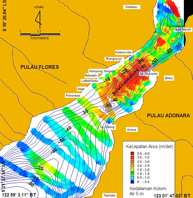
18 Larantuka Strait Simulated flux density during spring-flood tide at depth of m (Juventus in Yuningsih, et al., 09) Simulated flux density during spring-ebb tide at depth of m (Juventus in Yuningsih, et al., 09)
 Simulated flux density during spring-ebb tide at depth of m (Hadi,")
19 Lombok Strait Simulated flux density during spring-flood tide at depth of m (Hadi, 06) Simulated flux density during spring-ebb tide at depth of m (Hadi, 06)
 Simulated flux density during spring-ebb tide at depth of m (Huda,")
20 Alas Strait Simulated flux density during spring-flood tide at depth of m (Huda, 06) Simulated flux density during spring-ebb tide at depth of m (Huda, 06)

21 00:47:48 Ocean Current in Sunda Strait

22 Ocean Current in Sunda Strait 04:00
23 DURING NEAP TIDE Current velocity: - average = 0.94 m/sec. - maximum = 2.52 m/sec (occurs 9 hrs prior to flood).

24 DURING NEAP TIDE Current velocity: - average = 1.38 m/sec. - maximum = 1.99 m/sec (occurs 2 hrs after lowest ebb).
.")
25 DURING SPRING TIDE Current velocity: - average = 1.38 m/sec. - maximum = 3.97 m/sec (occurs 6 hrs after highest flood).
.")
26 DURING SPRING TIDE Current velocity: - average = 1.36 m/sec. - maximum = 4.59 m/sec (occurs 3 hrs prior to lowest ebb).


27 Bathymetric Map of Mansuar Strait, Raja Ampat Lokasi penelitian 131 ' 53" Weigeo 131 ' 53" -0 52' 55" 1 0' 28" 0 5' 4" 1 0' 28" -0 52' 55" PETA INDEKS 0 5' 4" 1 41' ' 24" 1 41' 19.19" -0 36' 45" 1 ' 4" -0 ' 24" -0 36' 45" 1 ' 4" SELAT DAMPIER P. MANSUAR KEMENTERIAN ENERGI DAN SUMBERDAYA MINERAL PUSAT PENELITIAN DAN PENGEMBANGAN GEOLOGI KELAUTAN Digambar oleh Disyahkan oleh Diperiksa oleh Mira Yosi, M. Si PETA BATIMETRI DI PERAIRAN Navigator Penyusun Pengamat : Kontur batimetri interval 5 meter : Ibukota Kabupaten/Kecamatan : Sungai : Jalan KETERANGAN : 4 KM Ocean Current in Raja Ampat Islands

28 Reference cm/sec Velocity cm/sec Ocean current vectors at water depth of 1 24 m from Sawinggrai Village
29 00:47: MGI MAPPING PROGRAMS Ocean Thermal Mapping: Collecting CTD data of previous expedition into a single data base Setting up CTD measurements as a routine task within systematic marine geological and geophysical mapping programs Begin applying of seismic oceanography methodology on already acquired multichannel seismic data Setting up paleoclimatic/oceanographic research collaborations with Indonesian Agency for Marine & Fisheries and FIO (China), French-Legos Ocean Current Mapping: Field mapping focuses Natuna islands and northern Sulawesi. To issue the first edition of Ocean Current Energy Map (December 13).
30 00:47: MGI MAPPING PROGRAMS SEISMIC OCEANOGRAPHY: A new cross discipline between oceanography and seismology Application of multichannel seismic reflection method to the investigation of thermohaline fine structures of the ocean. Since MGI has acquired significant amounts of multichannel seismic reflection data, particularly in eastern Indonesia. It is expected that new methodology applied to those seismic data will result in comprehensive understanding of thermohaline structure of Indonesian waters (in addition to the field measurements of CTD).


31 00:47: MGI MAPPING PROGRAMS


32 9/23/13
Upper Layer Variability of Indonesian Throughflow
 Upper Layer Variability of Indonesian Throughflow R. Dwi Susanto 1, Guohong Fang 2, and Agus Supangat 3 1. Lamont-Doherty Earth Observatory of Columbia University, New York USA 2. First Institute of Oceanography,
The observation of the Pacific-Indian Ocean transport and its South China Sea branch
 The observation of the Pacific-Indian Ocean transport and its South China Sea branch Shujiang Li 1, Zexun Wei 1, Guohong Fang 1, Budi Sulistiyo 2, R. Dwi Susanto 3, Agus Setiawan 2 1. First Institute of
INDONESIAN THROUGHFLOW AND ITS PROXY FROM SATELLITE ALTIMETERS AND GRAVIMETERS
 INDONESIAN THROUGHFLOW AND ITS PROXY FROM SATELLITE ALTIMETERS AND GRAVIMETERS R. Dwi Susanto 1, Tony Song 2, Zexun Wei 3, Jiayi Pan 4 1 Department of Atmospheric and Oceanic Science University of Maryland,
Initial Observation of High Resolution Velocity Profile and Stratification in the Sunda Strait
 Initial Observation of High Resolution Velocity Profile and Stratification in the Sunda Strait LONG-TERM GOALS PI: R. Dwi Susanto Lamont-Doherty Earth Observatory of Columbia University 61 Route 9W, Palisades,
Strait Flow Monitoring Using Trawl Resistant Bottom Mounted Acoustic Doppler Current Profilers
 Strait Flow Monitoring Using Trawl Resistant Bottom Mounted Acoustic Doppler Current Profilers PI: R. Dwi Susanto Lamont-Doherty Earth Observatory of Columbia University 61 Route 9W, Palisades, NY 10964
Bay of Bengal Surface and Thermocline and the Arabian Sea
 DISTRIBUTION STATEMENT A. Approved for public release; distribution is unlimited. Bay of Bengal Surface and Thermocline and the Arabian Sea Arnold L. Gordon Lamont-Doherty Earth Observatory of Columbia
DRIVEN LARVAL TRANSPORT ON SALEH BAY, SUMBAWA, INDONESIA *)
") BAROTROPIC TIDAL AND WIND-DRIVEN DRIVEN LARVAL TRANSPORT ON SALEH BAY, SUMBAWA, INDONESIA *) Widodo S. Pranowo 1), Yulia Herdiani 2) Ivonne M. Radjawane 3) 2), *) Presenting on WOM-12 APEC/MRC/OMISAR in
BAROTROPIC TIDAL AND WIND-DRIVEN DRIVEN LARVAL TRANSPORT ON SALEH BAY, SUMBAWA, INDONESIA *) Widodo S. Pranowo 1), Yulia Herdiani 2) Ivonne M. Radjawane 3) 2), *) Presenting on WOM-12 APEC/MRC/OMISAR in
Upper-Ocean Processes and Air-Sea Interaction in the Indonesian Seas
 Upper-Ocean Processes and Air-Sea Interaction in the Indonesian Seas Janet Sprintall, Scripps Institution of Oceanography, USA Arnold L. Gordon, Asmi M. Napitu, LDEO, USA Ariane Koch-Larrouy, LEGOS, France
A NUMERICAL EXPERIMENT OF 50-DAY RESONANCE INDUCED BY INDIAN OCEAN KELVIN WAVE IN THE SULAWESI SEA
 A NUMERICAL EXPERIMENT OF 50-DAY RESONANCE INDUCED BY INDIAN OCEAN KELVIN WAVE IN THE SULAWESI SEA Fadli Syamsudin Center for Research and Development of Technology for Natural Resources Inventory, Agency
Marine Current Potential Energy for Environmental Friendly Electricity Generation in Bali, Lombok and Makassar Straits
 Environmental Technology and Management Conference 2006 September 7-8, 2006 Bandung, West Java, Indonesia Marine Current Potential Energy for Environmental Friendly Electricity Generation in Bali, Lombok
TSUNAMI AND EARTHQUAKE ACTIVITY IN INDONESIA *
 LOCAL TSUNAMI WARNING AND MITIGATION TSUNAMI AND EARTHQUAKE ACTIVITY IN INDONESIA * Nanang T. Puspito Department of Geophysics and Meteorology, Institute of Technology Bandung (ITB) Address: Jalan Ganeca
the only tropical inter-ocean exchange site (~15 Sv) transports heat and freshwater from Pacific into Indian Ocean pressure gradient between Pacific
 transports heat and freshwater from Pacific into Indian Ocean pressure gradient between Pacific") Upper-Ocean Processes and Air-Sea Interaction in the Indonesian Seas Janet Sprintall, Scripps Institution of Oceanography, USA Arnold L. Gordon, Asmi M. Napitu, LDEO, USA Ariane Koch-Larrouy,, LEGOS, France
Upper-Ocean Processes and Air-Sea Interaction in the Indonesian Seas Janet Sprintall, Scripps Institution of Oceanography, USA Arnold L. Gordon, Asmi M. Napitu, LDEO, USA Ariane Koch-Larrouy,, LEGOS, France
Upper Ocean Circulation
 Upper Ocean Circulation C. Chen General Physical Oceanography MAR 555 School for Marine Sciences and Technology Umass-Dartmouth 1 MAR555 Lecture 4: The Upper Oceanic Circulation The Oceanic Circulation
Regional Stratification and Shear of the Various Streams Feeding the Philippine Straits
 Regional Stratification and Shear of the Various Streams Feeding the Philippine Straits Arnold L. Gordon Lamont-Doherty Earth Observatory 61 Route 9W Palisades, NY 10964-8000 tele: 845 365-8325 fax: 845
Coherence of transport variability along outer Banda Arcs
 IOP Conference Series: Earth and Environmental Science PAPER OPEN ACCESS Coherence of transport variability along outer Banda Arcs To cite this article: V C Masoleh and A S Atmadipoera 2018 IOP Conf. Ser.:
Originally published as:
 Originally published as: Henstock, T., McNeill, L., Dean, S., Barton, P., Tilmann, F., Rietbrock, A., Robinson, D., Gulick, S., Austin, J., Djajadihardja, Y., Natawidjaja, D., Permana, H., Bonneville,
Analysis of Sub-Mesoscale Features in Indonesian Seas
 Analysis of Sub-Mesoscale Features in Indonesian Seas R. Dwi Susanto Lamont-Doherty Earth Observatory of Columbia University 61 Route 9W, Palisades, NY 10964 Phone: 845-365-8545 fax: 845-365-8157 e-mail:
Tomography Lombok Strait Meeting 2015:
 -Second Circular (plan)- Tomography Lombok Strait Meeting 2015: A vast challenge to monitor Indonesian Throughflow (ITF) Date: November 3-7, 2015 Co-conveners: Fadli Syamsudin, Xiaohua Zhu, Chen-Fen Huang
OCEANOGRAPHY OF THE INDONESIAN SEAS
 OCEANOGRAPHY OF THE INDONESIAN SEAS Arnold L. Gordon Lamont-Doherty Earth Observatory Palisades, NY 10964-8000 tele: (914) 365-8325 fax (914) 365-8157 agordon@ldeo.columbia.edu Award Number N00014-90-J-1233
General Oceanography Geology 105 Expedition #17 Tracking Drifter Buoys See Due Date in Greensheet or in Module Area of Canvas
 General Oceanography Name Geology 105 Expedition #17 Tracking Drifter Buoys See Due Date in Greensheet or in Module Area of Canvas Expedition Objective: Students will apply a scientific approach to study
Indonesian seas Numerical Assessment of the Coastal Environment (IndoNACE) Executive Summary
 Executive Summary") Indonesian seas Numerical Assessment of the Coastal Environment (IndoNACE) Executive Summary Study team members: Dr. Martin Gade, PD Dr. Thomas Pohlmann, Dr. Mutiara Putri Research Centres: Universität
Indonesian seas Numerical Assessment of the Coastal Environment (IndoNACE) Executive Summary Study team members: Dr. Martin Gade, PD Dr. Thomas Pohlmann, Dr. Mutiara Putri Research Centres: Universität
Climate Change Research Centre
 Lagrangian particles to study the ocean circulation All trajectories of buoys in the Global Drifter Program Erik van Sebille With input from Matthew England, Judith Helgers, Claire Paris, Bernadette Sloyan,
Marginal Sea - Open Ocean Exchange
 Marginal Sea - Open Ocean Exchange Michael A. Spall Mail Stop 21 Department of Physical Oceanography Woods Hole Oceanographic Institution Woods Hole, MA 02543-1541 phone: (508) 289-3342 fax: (508) 457-2181
GEOLOGICAL HAZARD MITIGATION STRATEGY IN INDONESIA
 GEOLOGICAL HAZARD MITIGATION STRATEGY IN INDONESIA Surono Head of Geological Agency presented in: The 2nd Global Summit of Research Institutes for Disaster Risk Reduction Kihada Hall, Uji Campus, Kyoto
Report of the CLIVAR ITF Task Team Meeting
 Project Report Report of the CLIVAR ITF Task Team Meeting Jakarta, Indonesia 12 th 14 th March 2012 March 2013 WCRP Informal/Series Report No. 20/2013 ICPO Informal Report 193/13 CLIVAR is a component
SIO 210 Problem Set 2 October 17, 2011 Due Oct. 24, 2011
 SIO 210 Problem Set 2 October 17, 2011 Due Oct. 24, 2011 1. The Pacific Ocean is approximately 10,000 km wide. Its upper layer (wind-driven gyre*) is approximately 1,000 m deep. Consider a west-to-east
Makassar Strait is the primary pathway of the Pacific
 MAKASSAR STRAIT TRANSPORT: PRELIMINARY ARLINDO RESULTS FROM MAK-1 AND MAK-2 Arnold L. Gordon, R. Dwi Susanto*, Amy Ffield Lamont-Doherty Earth Observatory, Palisades NY. 1964-8 and Dale Pillsbury Oregon
Project of Strategic Interest NEXTDATA. Deliverables D1.3.B and 1.3.C. Final Report on the quality of Reconstruction/Reanalysis products
 Project of Strategic Interest NEXTDATA Deliverables D1.3.B and 1.3.C Final Report on the quality of Reconstruction/Reanalysis products WP Coordinator: Nadia Pinardi INGV, Bologna Deliverable authors Claudia
ATOC 5051 INTRODUCTION TO PHYSICAL OCEANOGRAPHY. Lecture 2
 ATOC 5051 INTRODUCTION TO PHYSICAL OCEANOGRAPHY Lecture 2 Ocean basins and relation to climate Learning objectives: (1)What are the similarities and differences among different ocean basins? (2) How does
DeepSea Minerals Research in Indonesia : Status and Challenges
 KEMENTERIAN MINISTRY OF ENERGY ENERGI AND DAN MINERAL SUMBER RESOURCES DAYA MINERAL REPUBLIK REPUBLIC OF INDONESIA DeepSea Minerals Research in Indonesia : Status and Challenges Noor C.D Aryanto and Ediar
STUDY ON SEA LEVEL RISE IN THE WESTERN INDONESIA * )
") STUDY ON SEA LEVEL RISE IN THE WESTERN INDONESIA * ) by Hadikusumah ** ) ABSTRACT Study on mean sea level (MSL) rise has been done on tide data at some locations in the Western Indonesia. To account the
STUDY ON SEA LEVEL RISE IN THE WESTERN INDONESIA * ) by Hadikusumah ** ) ABSTRACT Study on mean sea level (MSL) rise has been done on tide data at some locations in the Western Indonesia. To account the
JCOMM-CHy Coastal Inundation Forecasting Demonstration Project (CIFDP)
") WMO World Meteorological Organization Working together in weather, climate and water JCOMM-CHy Coastal Inundation Forecasting Demonstration Project (CIFDP) Coastal Flooding & Vulnerable Populations Coastal
WMO World Meteorological Organization Working together in weather, climate and water JCOMM-CHy Coastal Inundation Forecasting Demonstration Project (CIFDP) Coastal Flooding & Vulnerable Populations Coastal
Internal Tide Generation in the Indonesian Seas
 Internal Tide Generation in the Indonesian Seas Amy Ffield Earth and Space Research, 290 Clausland Mountain Road, Upper Grandview, NY 10960 Phone: (845) 353-1733 Fax: (845) 353-1733 Email: ffield@esr.org
How Much Water Passes through the Indonesian Passages?
 How Much Water Passes through the Indonesian Passages? Doron Nof Department of Oceanography 4320 Florida State University Tallahassee, FL 32306-4320 Phone: (850) 644-2736 fax: (850) 644-2581 email: nof@ocean.fsu.edu
STUDY ON TSUNAMIGENIC EARTHQUAKE CRITERIA FOR THE INDONESIAN TSUNAMI EARLY WARNING SYSTEM
 STUDY ON TSUNAMIGENIC EARTHQUAKE CRITERIA FOR THE INDONESIAN TSUNAMI EARLY WARNING SYSTEM Nanang T. Puspito 1 1 Geophysics Research Group, Faculty of Mining and Petroleum Engineering, Institute of Technology
Wave Climate Variations in Indonesia Based on ERA-Interim Reanalysis Data from 1980 to 2014
 Wave Climate Variations in Indonesia Based on ERA-Interim Reanalysis Data from 1980 to 2014 Muhammad Zikra, a,* and Putika Ashfar b a) Department of Ocean Engineering, Institut Teknologi Sepuluh Nopember
OCEANOGRAPHY CURRICULUM. Unit 1: Introduction to Oceanography
 Chariho Regional School District - Science Curriculum September, 2016 OCEANOGRAPHY CURRICULUM Unit 1: Introduction to Oceanography OVERVIEW Summary In this unit students will be introduced to the field
1. Oceans. Example 2. oxygen.
 1. Oceans a) Basic facts: There are five oceans on earth, making up about 72% of the planet s surface and holding 97% of the hydrosphere. Oceans supply the planet with most of its oxygen, play a vital
Coastal Vulnerability Assessment in Semarang City, Indonesia Based on Sea Level Rise and Land Subsidence Scenarios
 Coastal Vulnerability Assessment in Semarang City, Indonesia Based on Sea Level Rise and Land Subsidence Scenarios I. M. Radjawane, D. Hartadi and W. R. Lusano Oceanography Research Division Fac. of Earth
Upper Ocean Measurements of Water Masses and Circulation in the Japan Sea
 Upper Ocean Measurements of Water Masses and Circulation in the Japan Sea Stephen C. Riser School of Oceanography, University of Washington, Seattle, Washington 98195 USA Phone: (206) 543-1187 Fax: (206)
THERMOHALINE OCEAN CIRCULATION IN MAKRAN COASTS-IRAN by
 THERMOHALINE OCEAN CIRCULATION IN MAKRAN COASTS-IRAN by Mohammad Bagheri 1, M. Reza Allahyar 1, Mehdi Shafieefar 2, M. Hosein Nemati 1, Ali Ghasemi 2, Ahmad Rezaei 2 ABSTRACT Ocean currents are generated
Southeast Asia Oceanography
 Southeast Asia Oceanography Arnold L. Gordon Lamont-Doherty Earth Observatory Palisades, NY 1964-8 tele: (914) 365-8325 fax (914) 365-8157 agordon@ldeo.columbia.edu Grant Number N14-98-1-27 Arlindo Web
ARTICLE IN PRESS. Deep-Sea Research I
 Deep-Sea Research I 56 (2009) 1942 1954 Contents lists available at ScienceDirect Deep-Sea Research I journal homepage: www.elsevier.com/locate/dsri Characteristics and variability of the Indonesian throughflow
Sea Level Variability in the East Coast of Male, Maldives
 Sea Level Variability in the East Coast of Male, Maldives K.W. Indika 1 *, E.M.S. Wijerathne 2, G. W. A. R. Fernando 3, S.S.L.Hettiarachchi 4 1 National Aquatics Resources Research and Development Agency,
Ocean surface circulation
 Ocean surface circulation Recall from Last Time The three drivers of atmospheric circulation we discussed: Differential heating Pressure gradients Earth s rotation (Coriolis) Last two show up as direct
PREDICTION OF OIL SPILL TRAJECTORY WITH THE MMD-JMA OIL SPILL MODEL
 PREDICTION OF OIL SPILL TRAJECTORY WITH THE MMD-JMA OIL SPILL MODEL Project Background Information MUHAMMAD HELMI ABDULLAH MALAYSIAN METEOROLOGICAL DEPARTMENT(MMD) MINISTRY OF SCIENCE, TECHNOLOGY AND INNOVATION
Models of Marginal Seas Partially Enclosed by Islands
 Models of Marginal Seas Partially Enclosed by Islands Roxana C. Wajsowicz Dept. of Meteorology University of Maryland 3433 Computer and Space Science Building College Park, MD 20852 Phone: (301) 405-5396
Variability and trend of the heat balance in the southeast Indian Ocean
 Variability and trend of the heat balance in the southeast Indian Ocean Ming Feng, CSIRO Marine & Atmospheric Research Arne Biastoch, Claus Böning, Leibniz-Institut für Meeresforschung Nick Caputi, Department
Ocean Circulation. In partnership with Dr. Zafer Top
 Ocean Circulation In partnership with Dr. Zafer Top Samantha Hampton Honors Science December 15, 2014 Ocean Circulation is the large scale movement of waters in the ocean basins. Dr. Zafer Top studies
Measuring the Flow through the Kerama Gap
 DISTRIBUTION STATEMENT A. Approved for public release; distribution is unlimited. Measuring the Flow through the Kerama Gap Mark Wimbush & Jae-Hun Park Graduate School of Oceanography University of Rhode
Deep water masses exchange induced by internal tidal waves in Ombai Strait
 IOP Conference Series: Earth and Environmental Science PAPER OPEN ACCESS Deep water masses exchange induced by internal tidal waves in Ombai Strait To cite this article: A S Atmadipoera and Y Suteja 2018
Oceanography Quiz 2. Multiple Choice Identify the choice that best completes the statement or answers the question.
 Oceanography Quiz 2 Multiple Choice Identify the choice that best completes the statement or answers the question. 1. The highest and lowest tides are known as the spring tides. When do these occur? a.
Pacific HYCOM. E. Joseph Metzger, Harley E. Hurlburt, Alan J. Wallcraft, Luis Zamudio and Patrick J. Hogan
 Pacific HYCOM E. Joseph Metzger, Harley E. Hurlburt, Alan J. Wallcraft, Luis Zamudio and Patrick J. Hogan Naval Research Laboratory, Stennis Space Center, MS Center for Ocean-Atmospheric Prediction Studies,
CHAPTER IV THE RELATIONSHIP BETWEEN OCEANOGRAPHY AND METEOROLOGY
 CHAPTER IV THE RELATIONSHIP BETWEEN OCEANOGRAPHY AND METEOROLOGY THE relationship between oceanography and meteorology is of an order different from that between it and geology or biology, because meteorologic
LONG TERM VARIATIONS OF SIGNIFICANT WAVE HEIGHT AROUND INDONESIA SEAS
 International Journal of Civil Engineering and Technology (IJCIET) Volume 9, Issue 9, September 2018, pp. 933 941, Article ID: IJCIET_09_09_089 Available online at http://www.iaeme.com/ijciet/issues.asp?jtype=ijciet&vtype=9&itype=9
Appendix G.19 Hatch Report Pacific NorthWest LNG Lelu Island LNG Maintenance Dredging at the Materials Offloading Facility
 Appendix G.19 Hatch Report Pacific NorthWest LNG Lelu Island LNG Maintenance Dredging at the Materials Offloading Facility Project Memo H345670 To: Capt. David Kyle From: O. Sayao/L. Absalonsen December
OCEANOGRAPHY II NOTES
 TIDES OCEANOGRAPHY II NOTES MRS. BURKEY EARTH SPACE SCIENCE CY CREEK HS THE RISE AND FALL IN SEA LEVEL IS CALLED A TIDE. CAUSED BY A GIANT WAVE. AVERAGE LOW-TIDE/HIGH-TIDE CYCLE TAKES ABOUT 12 HRS AND
A Statistical Investigation of Internal Wave Propagation in the Northern South China Sea
 DISTRIBUTION STATEMENT A. Approved for public release; distribution is unlimited. A Statistical Investigation of Internal Wave Propagation in the Northern South China Sea Ping-Tung Shaw Dept of MEAS, North
Coastal Erosion & Climate Change: PRIDE 2005 Towards an Alaska Wind/Wave Climatology
 Coastal Erosion & Climate Change: PRIDE 2005 Towards an Alaska Wind/Wave Climatology 2 nd PRIDE Workshop August 9-10, 2005 David Atkinson, Int l Arctic Research Center, Univ. Of Alaska-Fairbanks James
Pathways in the ocean
 Pathways Pathways in the in the ocean by Sybren Drijfhout Introduction The properties of water masses in the ocean are set by air-sea interactions at the surface and convective overturning. As direct transfer
Question: What is the primary reason for the great abundance of fish along the Peruvian coast?
 Buzzer Question # 1 Question Type: toss-up Question Format: Multiple Choice Category: Biology What is the primary reason for the great abundance of fish along the Peruvian coast? Answer W: upwelling Answer
The International Indian Ocean Expedition. Mika ODIDO IOC Sub Commission for Africa and the Adjacent Island States
 The International Indian Ocean Expedition Mika ODIDO IOC Sub Commission for Africa and the Adjacent Island States INDIAN OCEAN Facts and Figures 3rd largest ocean (after Pacific and Atlantic) Extent from
Preface to the special issue of Dynamics of Atmosphere and Ocean: Modeling and Observing the Indonesian Throughflow
 December 00, The Indonesian Throughflow during 00-00, revised for DYNAT 0 0 0 Preface to the special issue of Dynamics of Atmosphere and Ocean: Modeling and Observing the Indonesian Throughflow The Indonesian
Oceanography II Notes
 Oceanography II Notes Tides The rise and fall in sea level is called a tide. Caused by a giant wave and the gravitational pull of the moon and sun on the ocean One low-tide/high-tide cycle takes about
Circulation in the South China Sea in summer of 1998
 Circulation in the South China Sea in summer of 1998 LIU Yonggang, YUAN Yaochu, SU Jilan & JIANG Jingzhong Second Institute of Oceanography, State Oceanic Administration (SOA), Hangzhou 310012, China;
THE OPEN UNIVERSITY OF SRI LANKA
 THE OPEN UNIVERSITY OF SRI LANKA Extended Abstracts Open University Research Sessions (OURS 2017) 16 th & 17 th November, 2017 The Open University of Sri Lanka - 2017 All rights reserved. No part of this
I. INTRODUCTION 1.1. Background and Problem Statement
 I. INTRODUCTION 1.1. Background and Problem Statement The declining of global oil and gas reserves has encouraged the exploration campaign to both the frontier area and the revisit to the mature basins.
On strategy for the development of the Russian Federation activities in the Antarctic for the period until 2020 and longer-term perspective
 Agenda Item: ATCM 5 Presented by: Original: Russian Federation Russian, English On strategy for the development of the Russian Federation activities in the Antarctic for the period until 2020 and longer-term
Chapter 1: Earth as a System
 Chapter 1: Earth as a System Science is: Any system of knowledge which tries to observe, identify, understand and describe the nature of the Universe in whole or part. Science explains and predicts the
PUBLICATIONS. Journal of Geophysical Research: Oceans
 PUBLICATIONS Journal of Geophysical Research: Oceans RESEARCH ARTICLE 1.1/13JC9 Key Points: Pacific and Indian Oceans are connected through ITF and Tasman leakage Both pathways are important for global
Direct estimates of the Indonesian Throughflow entering the Indian Ocean:
 Click Here for Full Article JOURNAL OF GEOPHYSICAL RESEARCH, VOL. 114,, doi:10.1029/2008jc005257, 2009 Direct estimates of the Indonesian Throughflow entering the Indian Ocean: 2004 2006 Janet Sprintall,
ECONOMIC AND SOCIAL COUNCIL 10 July 2007
 UNITED NATIONS E/CONF.98/CRP.22 ECONOMIC AND SOCIAL COUNCIL 10 July 2007 Ninth United Nations Conference on the Standardization of Geographical Names New York, 21-30 August 2007 Item 9(a) of the provisional
VALIDATION OF ALTIMETER SIGNIFICANT WAVE HEIGHT USING WAVE GAUGE MEASUREMENT IN PACITAN COASTAL WATERS, EAST JAVA, INDONESIA
 VALIDATION OF ALTIMETER SIGNIFICANT WAVE HEIGHT USING WAVE GAUGE MEASUREMENT IN PACITAN COASTAL WATERS, EAST JAVA, INDONESIA *Yati Muliati, **Andojo Wurjanto, *** Widodo S. Pranowo * Institut Teknologi
Ocean circulation, sedimentation in the San Juans - compilation of mainstream scientific literature by Dave Hyde -
 Ocean circulation, sedimentation in the San Juans - compilation of mainstream scientific literature by Dave Hyde - Salish Sea has 3 principal estuaries SG, JDF,PS San Juan Islands ocean setting uniquely
UPDATE OF REGIONAL WEATHER AND SMOKE HAZE November 2016
 UPDATE OF REGIONAL WEATHER AND SMOKE HAZE November 2016 1. Review of Regional Weather Conditions in November 2016 1.1 Southwest Monsoon conditions prevailed on most days in October 2016 and the winds were
Near-Surface Dispersion and Circulation in the Marmara Sea (MARMARA)
") DISTRIBUTION STATEMENT A. Approved for public release; distribution is unlimited. Near-Surface Dispersion and Circulation in the Marmara Sea (MARMARA) Pierre-Marie Poulain Istituto Nazionale di Oceanografia
DISTRIBUTION STATEMENT A. Approved for public release; distribution is unlimited. Near-Surface Dispersion and Circulation in the Marmara Sea (MARMARA) Pierre-Marie Poulain Istituto Nazionale di Oceanografia
Indian Ocean Forecast System (INDOFOS) Abhisek Chatterjee
 Abhisek Chatterjee") Indian Ocean Forecast System (INDOFOS) Abhisek Chatterjee Earth System Sciences Organisation (ESSO) Indian National Centre for Ocean Information Services (INCOIS) Ministry of Earth Sciences, Government
Indian Ocean Forecast System (INDOFOS) Abhisek Chatterjee Earth System Sciences Organisation (ESSO) Indian National Centre for Ocean Information Services (INCOIS) Ministry of Earth Sciences, Government
Bay of Bengal Surface and Thermocline and the Arabian Sea
 DISTRIBUTION STATEMENT A. Approved for public release; distribution is unlimited. Bay of Bengal Surface and Thermocline and the Arabian Sea Arnold L. Gordon Lamont-Doherty Earth Observatory 61 Route 9W
Oceans I Notes. Oceanography
 Oceans I Notes Outlines on the front table Oceanography the science of our oceans that mixes biology, geology, chemistry, and physics (among other sciences) to unravel the mysteries of our seas. Divisions
South & South East Asian Region:
 Issued: 10 th November 2017 Valid Period: December 2017 May 2018 South & South East Asian Region: Indonesia Tobacco Regions 1 A] Current conditions: 1] El Niño-Southern Oscillation (ENSO) ENSO Alert System
Power Engineering II. Fundamental terms and definitions
 Fundamental terms and definitions Power engineering A scientific discipline that focuses on: Generation of electrical energy (EE) Transmission and distribution of EE Consumption of EE Power grid operation
CHAPTER 9 ATMOSPHERE S PLANETARY CIRCULATION MULTIPLE CHOICE QUESTIONS
 CHAPTER 9 ATMOSPHERE S PLANETARY CIRCULATION MULTIPLE CHOICE QUESTIONS 1. Viewed from above in the Northern Hemisphere, surface winds about a subtropical high blow a. clockwise and inward. b. counterclockwise.
Arnold L. Gordon Retroflections and Bifurcations Johann Lutjeharms Memorial Lecture
 The Agulhas System and its Role in Changing Ocean Circulation, Climate & Marine Ecosystems Spier Hotel, Stellenbosch, Western Cape, South Africa 8 12 October 2012 Brazil/Malvinas Agulhas Retroflection
Coastal Ocean Circulation Experiment off Senegal (COCES)
") DISTRIBUTION STATEMENT A: Approved for public release; distribution is unlimited. Coastal Ocean Circulation Experiment off Senegal (COCES) Pierre-Marie Poulain Istituto Nazionale di Oceanografia e di Geofisica
DISTRIBUTION STATEMENT A: Approved for public release; distribution is unlimited. Coastal Ocean Circulation Experiment off Senegal (COCES) Pierre-Marie Poulain Istituto Nazionale di Oceanografia e di Geofisica
Ice and Ocean Mooring Data Statistics from Barrow Strait, the Central Section of the NW Passage in the Canadian Arctic Archipelago
 Ice and Ocean Mooring Data Statistics from Barrow Strait, the Central Section of the NW Passage in the Canadian Arctic Archipelago Simon Prinsenberg and Roger Pettipas Bedford Institute of Oceanography,
Casco Bay Estuary Partnership (CBEP) USM Muskie School 34 Bedford St 228B. Portland, ME
 USM Muskie School 34 Bedford St 228B. Portland, ME") Casco Bay Estuary Partnership (CBEP) USM Muskie School 34 Bedford St 228B Wishcamper Center Portland, ME 04104 9300 Malcolm L. Spaulding Applied Science Associates 55 Village Square Drive South Kingstown,
Casco Bay Estuary Partnership (CBEP) USM Muskie School 34 Bedford St 228B Wishcamper Center Portland, ME 04104 9300 Malcolm L. Spaulding Applied Science Associates 55 Village Square Drive South Kingstown,
Chapter 6 The lithosphere and the hydrosphere
 Chapter 6 The lithosphere and the hydrosphere The lithosphere shell of the Earth, consists of crust and upper mantle contains minerals and rocks 1. Minerals solid, inorganic substances with defined composition
The Ocean Floor THE VAST WORLD OCEAN
 OCEANOGRAPHY Name Color all water LIGHT BLUE. Color all land LIGHT GREEN. Label the 5 Oceans: Pacific, Atlantic, Indian, Arctic, Antarctic. Label the 7 Continents: N.America, S.America, Europe, Asia, Africa,
Deep-Water Flow over the Lomonosov Ridge in the Arctic Ocean
 AUGUST 2005 N O T E S A N D C O R R E S P O N D E N C E 1489 Deep-Water Flow over the Lomonosov Ridge in the Arctic Ocean M.-L. TIMMERMANS, P. WINSOR, AND J. A. WHITEHEAD Woods Hole Oceanographic Institution,
The route towards a new GEBCO grid
 The route towards a new GEBCO grid Pauline Weatherall, GEBCO Digital Atlas Manager British Oceanographic Data Centre (BODC) GEBCO TSCOM/SCRUM meeting, Monaco, October 2012 The route towards a new GEBCO
You should be able to identify a few of the key cultures, individuals and expeditions in the history of marine science:
 Ocean History You should be able to identify a few of the key cultures, individuals and expeditions in the history of marine science: Phoenicians Arabs Micronesians Polynesians Aristotle Erikson Columbus
South & South East Asian Region:
 Issued: 15 th December 2017 Valid Period: January June 2018 South & South East Asian Region: Indonesia Tobacco Regions 1 A] Current conditions: 1] El Niño-Southern Oscillation (ENSO) ENSO Alert System
Measuring the Flow Through the Kerama Gap
 DISTRIBUTION STATEMENT A. Approved for public release; distribution is unlimited. Measuring the Flow Through the Kerama Gap Mark Wimbush & Jae-Hun Park Graduate School of Oceanography University of Rhode
Modelling of the Indonesian Throughflow on glacial-interglacial time-scales
 Modelling of the Indonesian Throughflow on glacial-interglacial time-scales Dissertation zur Erlangung des Doktorgrades der Mathematisch-Naturwissenschaftlichen Fakultät der Christian-Albrechts-Universität
Numerical Simulation of Hydrodynamic for Abrupt Bathymetry in Palu River Estuary
 Indian Journal of Science and Technology, Vol 10(29), DOI: 10.17485/ijst/2017/v10i29/116502, August 2017 ISSN (Print) : 0974-6846 ISSN (Online) : 0974-5645 Numerical Simulation of Hydrodynamic for Abrupt
Islands in Zonal Flow*
 689 Islands in Zonal Flow* MICHAEL A. SPALL Department of Physical Oceanography, Woods Hole Oceanographic Institution, Woods Hole, Massachusetts (Manuscript received 1 April 003, in final form 9 June 003)
Coupling of Wave and Hydrodynamic Models for Predicting Coastal Inundation: A case study in Jakarta and Semarang
 Coupling of Wave and Hydrodynamic Models for Predicting Coastal Inundation: A case study in Jakarta and Semarang http://peta-maritim.bmkg.go.id/cifdp/maps Nelly Florida Riama,Andri Ramdhani, Andi Eka Sakya,,
Policies and practices of remote sensing implementation in Indonesia
 Policies and practices of remote sensing implementation in Indonesia AGF 2014 Jakarta, 26 Nov 2014 Orbita Roswintiarti Deputy Chairman for Remote Sensing Affairs Outline Background Role of LAPAN in remote
Meridional circulation in the western coastal zone: Qinyan Liu +$ & Rui Xin Huang +* Guangzhou, China. February 2, 2010
 Meridional circulation in the western coastal zone: II. The regulation by pressure gradient set up through basin scale circulation and the western boundary current transport Qinyan Liu +$ & Rui Xin Huang
UNCLASSIFIED AD NUMBER LIMITATION CHANGES
 TO: UNCLASSIFIED AD NUMBER AD269590 LIMITATION CHANGES Approved for public release; distribution is unlimited. FROM: Distribution authorized to U.S. Gov't. agencies and their contractors; Administrative/Operational