California s New Earthquake Early Warning System And Why We Are Different
|
|
|
- Clement Hunt
- 5 years ago
- Views:
Transcription

1

2 Civilization exists by Geologic consent Subject to change without notice. -- Durant EERI SACRAMENTO CHAPTER CALIFORNIA STATE UNIVERSITY, SACRAMENTO APRIL 27, 2017 California s New Earthquake Early Warning System And Why We Are Different by John G. Parrish, Ph. D., PG


3 California s Geological Diversity


4 California Has Largest and Most Diverse Population and Economy


5 California Earthquakes in the Last 200 Years

6 75% National Earthquake Risk


7 What is an Earthquake? Sudden slip between two blocks of crust along a fault Elastic rebound theory Slip releases elastic strain energy Rock stores elastic strain energy


 Time")
8 Earthquake Waves The P-wave carries information and the S-wave carries energy. -Kanamori P-wave ~3.5 mi/sec S-wave ~2 mi/sec Seismogram (ground motion) Time P S PGA PGA = Peak Ground Acceleration

9 CALIFORNIA EARTHQUAKE PROBABILITIES (GENERAL) The colors on this California map represent the UCERF probabilities of having a nearby earthquake rupture (within 3 or 4 miles) of magnitude 6.7 or larger in the next 30 years. As shown in the table, the chance of having such an event somewhere in California exceeds 99%. The 30-year probability of an even more powerful quake of magnitude 7.5 or larger is about 46%.

10 Earthquake Probabilities Probabilities of an Earthquake in the Bay Area in the next 30 years.
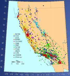
11 CISN California Integrated Seismic Network Core members USGS (Pasadena & Menlo Park) Caltech UC Berkeley Calif. Geological Survey (CSMIP) CalOES Participating members (real-time data contributors) UC San Diego UC Santa Barbara University of Nevada Reno Calif. Dept. of Water Resources Lawrence Livermore National Labs PG&E EarthScope - US Array/PBO CalEnergy Calpine CICESE And more

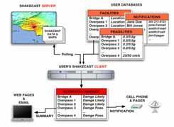

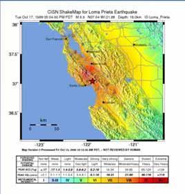
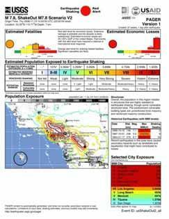
12 CISN Post-Earthquake Products ShakeMap CISN Display ShakeCast Pager ENS ShakeAlert
13 CISN California Integrated Seismic Network Shake Alert What is earthquake early warning? A warning seconds to minutes prior to shaking
14 CISN California Integrated Seismic Network Shake Alert What is it for? Allows individuals to duck, cover and hold on before shaking starts Allows automated systems to slow, stop, or switch to a safe mode Allows for situation awareness to reduce cascading failures Reduces the cost of earthquakes Reduces the the recovery time following earthquakes


15 First proposed by Cooper Earthquake early warning Timeline First proposed earthquake early warning system San Francisco, 1868 J.D. Cooper, MD, proposed: Detectors outside the city Use telegraph wires Earthquake bell Automated Will work for distant shocks


16 First proposed by Cooper Re-proposed by Tom Heaton Earthquake early warning Timeline +1

17 First proposed by Cooper Re-proposed by Tom Heaton Mexican warning system Earthquake early warning Timeline Built following the 1985 earthquake Operational since 1991 M7.2 April 18, 2014

18 First proposed by Cooper Re-proposed by Tom Heaton Mexican warning system Japanese warning system Earthquake early warning Timeline October 2007: Nationwide public warning system launched


19 First proposed by Cooper Re-proposed by Tom Heaton Mexican warning system Japanese warning system California demo system Earthquake early warning Timeline CISN California Integrated Seismic Network Shake Alert September 2011: First alert before felt shaking


20 First proposed by Cooper Re-proposed by Tom Heaton Mexican warning system Japanese warning system California demo system California legislation Earthquake early warning Timeline Introduced by Senator Alex Padilla Passed both houses unanimously Signed into law by Gov. Jerry Brown September 24, 2013 The law: CalOES to Develop statewide system Develop standards Identify funding (not taxes)

21 Who in the World is Doing EEW? Public notifications
 Reliable field telemetry")


22 Main Components of EEW System Dense sensors (seismic & GPS) Reliable field telemetry Fast processing to determine: Location, magnitude Fault extent & slip Fast mass notification End user interaction & education Sensors Field telemetry Processing Notifications Users


23 Pacific Northwest West Coast Centers EEW is a natural extension of ANSS & CISN core capabilities Northern California Leverage Technical Management Southern California Community engagement


24 California Integrated Seismic Network EARTHQUAKE EARLY WARNING APPLICATIONS HUMAN RESPONSES Drop, Cover, Hold On! Brace for Shaking (Surgeons, Dentists, Powerline Workers) Lower/Secure Crane Loads Evacuate Hazardous Areas


25 EARTHQUAKE EARLY WARNING APPLICATIONS AUTOMATED RESPONSES Slow or stop trains, traffic Close valves, gates Stop elevators Open firehouse doors Slow or stop machinery Close bridge gates California Integrated Seismic Network 25


26 M 7.8 Scenario Fault Rupture S-P time P-wave ~ 3.5 mi/sec S-wave ~ 2.0 mi/sec Rupture <2.0 mi/sec
27 Earthquake Begins M7.8 SoSAFZ Scenario
28 Stations Sense Shaking
 Up to 90 sec warning depending on distance.")
29 ShakeAlert Detects Event Issues Alert Blind Zone (no warning) Up to 90 sec warning depending on distance.
30 Rupture Moves Up Fault
31 Strong Shaking Arrives Palm Springs
32 Strong Shaking Arrives San Bernardino

33 Strong Shaking Arrives Orange Co.
34 Finite Fault Problem P-wave ~ 3.5 mi/sec S-wave ~ 2.0 mi/sec Rupture <2.0 mi/sec
35 P-wave ~ 3.5 mi/sec S- wave ~ 2.0 mi/sec Rupture <2.0 mi/sec Finite Fault Problem

36 User Display ShakeOut M7.8 Real-time Finite Fault Solution
37 User Display ShakeOut M7.8 Real-time Finite Fault Solution
38 User Display ShakeOut M7.8 Real-time Finite Fault Solution
39 User Display ShakeOut M7.8 Real-time Finite Fault Solution


40 Major EEW System Components Sensor Networks Field telemetry Processing Alert Creation Alert Delivery User Actions
")


41 Reliable Notification Internet Direct radio, VSAT, etc. Private partner systems FEMA-IPAWS (TV, radio, cell) alert authority RBDS - FM radio project Mass notification companies Partner redistribution Cloud services, phone app Google, Twitter? Sensor Networks Field telemetry Processing Alert Creation Alert Delivery User Actions


42 Current CISN EEW Status Status: Next three years: Production Prototype Thanks to partnerships Receiving alerts today: >50 scientists CalEMA Google.org BART LA Metro Metrolink San Francisco DEM Amgen So Cal Edison UC Berkeley OEP L.A. City L.A. County Riverside Co. San Bernardino Co. more

43 Thank You!
ShakeAlert Earthquake Early Warning
 ShakeAlert Earthquake Early Warning Doug Given USGS, Pasadena Earthquake Program, Early Warning Coordinator 10 seconds 50 seconds 90 seconds USGS Earthquake Hazard Responsibilities USGS has the lead federal
ShakeAlert Phase 1: West Coast Earthquake Early Warning. Doug Given, USGS EEW Coordinator Education Symposium, Dec. 4, 2018
 ShakeAlert Phase 1: West Coast Earthquake Early Warning Doug Given, USGS EEW Coordinator Education Symposium, Dec. 4, 2018 Population WA 7M OR 4M Annualized Earthquake Losses, $6.1B 61% in California,
Building earthquake early warning for the west coast. Ken Creager Professor of Earth and Space Sciences University of Washington
 Building earthquake early warning for the west coast Ken Creager Professor of Earth and Space Sciences University of Washington How Earthquake Early Warning works: P-waves S-waves 3-fold way of Earthquake
Overview. Tools of the Trade. USGS Decision-Making Tools for Pre-Earthquake Mitigation and Post-Earthquake Response
 USGS Decision-Making Tools for Pre-Earthquake Mitigation and Post-Earthquake Response Tools of the Trade DAVID WALD United States Geological Survey NEHRP Workshop: Developing Earthquake Scenarios Sept
Earthquake early warning: Adding societal value to regional networks and station clusters
 Earthquake early warning: Adding societal value to regional networks and station clusters Richard Allen, UC Berkeley Seismological Laboratory rallen@berkeley.edu Sustaining funding for regional seismic
UC Berkeley Berkeley Scientific Journal
 UC Berkeley Berkeley Scientific Journal Title Earthquakes Induced by Stress Permalink https://escholarship.org/uc/item/3br5k87m Journal Berkeley Scientific Journal, 18(1) ISSN 2373-8146 Author Singh, Harjit
Seismic Recording Station TA_109C Summary Report
 Seismic Recording Station TA_109C Summary Report Thank you for hosting station TA_109C on your property. We hope that you find the enclosed report interesting. Your station is one of the 2000 USArray seismic
How to communicate Cascadia Subduction Zone earthquake hazards
 How to communicate Cascadia Subduction Zone earthquake hazards Tom Brocher Research Geophysicist Earthquake Science Center U.S. Geological Survey Menlo Park, California Seattle Post-Intelligencer Lessons
Seismic Recording Station AZ_PFO Summary Report
 Seismic Recording Station AZ_PFO Summary Report Thank you for hosting station AZ_PFO on your property. We hope that you find the enclosed report interesting. Your station is one of the 2000 USArray seismic
In the early morning hours of
 Figure 1. Brace that Chimney! Bracing of masonry chimneys is very difficult to do properly and has generally been ineffective in preventing their failure during earthquakes. While replacement of the chimney
New Findings Form Basis for Earthquake
 Page 1 of 5 enter key Advanced Se Español Français Pycckuú You Are In: USINFO > Products >Washfile 10 November 2005 New Findings Form Basis for Earthquake Warning System Tracking quake waves could give
CEETEP Related Digital Resources
 CEETEP Related Digital Resources The resources on the CEETEP DVD and USB drive include many items developed by or in collaboration with other organizations. Here we overview some of the partner and related
Three Fs of earthquakes: forces, faults, and friction. Slow accumulation and rapid release of elastic energy.
 Earthquake Machine Stick-slip: Elastic Rebound Theory Jerky motions on faults produce EQs Three Fs of earthquakes: forces, faults, and friction. Slow accumulation and rapid release of elastic energy. Three
TEGAM s Connection to the EarthScope Project
 TEGAM s Connection to the EarthScope Project Introduction The EarthScope Project is an undertaking funded by the National Science Foundation in partnership with the United States Geological Survey and
WESTERN STATES SEISMIC POLICY COUNCIL POLICY RECOMMENDATION Earthquake and Tsunami Planning Scenarios
 WESTERN STATES SEISMIC POLICY COUNCIL POLICY RECOMMENDATION 18-1 Earthquake and Tsunami Planning Scenarios Policy Recommendation 18-1 WSSPC strongly encourages states, provinces, territories, First Nations,
Magnitude 7.7 QUEEN CHARLOTTE ISLANDS REGION
 A major 7.7 magnitude earthquake struck at 8:04 PM local time in western British Columbia, Canada. The epicenter is located on Moresby Island, the southern large island in the Queen Charlotte Islands region.
Updated MCE R & MCE G Ground Motions in 2015 NEHRP Provisions (& ASCE/SEI 7-16)
") Updated MCE R & MCE G Ground Motions in 2015 NEHRP Provisions (& ASCE/SEI 7-16) EERI 2016 Seminar ASCE Geotechnical on Next Generation & Structural Engineering Attenuation Congress Models Nicolas Luco
Updated MCE R & MCE G Ground Motions in 2015 NEHRP Provisions (& ASCE/SEI 7-16) EERI 2016 Seminar ASCE Geotechnical on Next Generation & Structural Engineering Attenuation Congress Models Nicolas Luco
Earthquakes and Faulting
 Earthquakes and Faulting Crustal Strength Profile Quakes happen in the strong, brittle layers Great San Francisco Earthquake April 18, 1906, 5:12 AM Quake lasted about 60 seconds San Francisco was devastated
GROUND MOTION TIME HISTORIES FOR THE VAN NUYS BUILDING
 GROUND MOTION TIME HISTORIES FOR THE VAN NUYS BUILDING Prepared for the PEER Methodology Testbeds Project by Paul Somerville and Nancy Collins URS Corporation, Pasadena, CA. Preliminary Draft, Feb 11,
STEM Connections to the ShakeAlert Earthquake Early Warning System
 STEM Connections to the ShakeAlert Earthquake Early Warning System Instructors: Cynthia Pridmore, California Geological Survey, cpridmore@consrv.ca.gov Robert de Groot, US Geological Survey, rdegroot@usgs.gov
Magnitude 7.9 SE of KODIAK, ALASKA
 A magnitude 7.9 earthquake occurred at 12:31 am local time 181 miles southeast of Kodiak at a depth of 25 km (15.5 miles). There are no immediate reports of damage or fatalities. Light shaking from this
Magnitude 6.5 OFFSHORE NORTHERN CALIFORNIA
 A powerful offshore earthquake that struck near the Northern California coast left a hodgepodge of debris for communities to sort through Sunday but spared residents any serious injury. After 25,000 people
Chapter 13 EARTHQUAKES AND EARTH STRUCTURE. FIGURE 13.1 The elastic rebound theory explains the earthquake cycle. [Photo by G. K. Gilbert/USGS.
 FIGURE 13.2 Map of California, showing the segments of the San Andreas fault that ruptured in 1680, 1857, and 1906. [Southern California Earthquake Center.] Chapter 13 EARTHQUAKES AND EARTH STRUCTURE FIGURE
Earthquake. What is it? Can we predict it?
 Earthquake What is it? Can we predict it? What is an earthquake? Earthquake is the vibration (shaking) and/or displacement of the ground produced by the sudden release of energy. Rocks under stress accumulate
Surviving the Big One: Understanding and Preparing for a Major Earthquake in Western Oregon
 Surviving the Big One: Understanding and Preparing for a Major Earthquake in Western Oregon May 21, 2013 City of Salem Salem Public Library Althea Rizzo, Geological Hazards Program Coordinator Oregon Emergency
Magnitude 6.9 GULF OF CALIFORNIA
 A pair of strong earthquakes struck off the coast of Mexico early Thursday only minutes apart. The magnitude 6.9 and 6.2 were centered about 85 miles northeast of Guerrero Negro in the Mexican state of
#13 Earthquake Prediction
 #13 Earthquake Prediction Obvious importance Earthquake Prediction Save lives, reduce damage Earthquake Prediction - Types Long-range prediction - involves EQ probability over long time period (years to
Earthquakes. Photo credit: USGS
 Earthquakes Earthquakes Photo credit: USGS Pancaked Building - 1985 Mexico City Earthquakes don t kill people - buildings do! An earthquake is the motion or trembling of the ground produced by sudden displacement
San Andreas Movie Can It Happen?
 San Andreas Movie Can It Happen? Learning Objectives (LO) Lecture 14: Faults and Quakes Read: Chapter 10 and 11 Homework #12 due Thursday 12pm What we ll learn today:! 1. Compare strike-slip to dip-slip
Earthquakes.
 Earthquakes http://thismodernworld.com/comic-archive Elastic rebound http://projects.crustal.ucsb.edu/understanding/elastic/rebound.html Elastic rebound Rocks store energy elastically When stored stress
Earthquakes and Earth s Interior
 - What are Earthquakes? Earthquakes and Earth s Interior - The shaking or trembling caused by the sudden release of energy - Usually associated with faulting or breaking of rocks - Continuing adjustment
REAL-TIME ASSESSMENT OF EARTHQUAKE DISASTER IN YOKOHAMA BASED ON DENSE STRONG-MOTION NETWORK
 REAL-TIME ASSESSMENT OF EARTHQUAKE DISASTER IN YOKOHAMA BASED ON DENSE STRONG-MOTION NETWORK Saburoh MIDORIKAWA 1 And Susumu ABE 2 SUMMARY This paper describes a system for REal-time Assessment of earthquake
GPS Strain & Earthquakes Unit 5: 2014 South Napa earthquake GPS strain analysis student exercise
 GPS Strain & Earthquakes Unit 5: 2014 South Napa earthquake GPS strain analysis student exercise Strain Analysis Introduction Name: The earthquake cycle can be viewed as a process of slow strain accumulation
e-science on Earthquake Disaster Mitigation in Taiwan
 e-science on Earthquake Disaster Mitigation in Taiwan Eric Yen EGI User Forum, April 2011 ~50 earthquakes/day Taiwan Seismicity on Google Earth 0 15 30 70 100 150 km Eurasia Plate S01R Philippine Sea Plate
Earthquakes Earth, 9th edition, Chapter 11 Key Concepts What is an earthquake? Earthquake focus and epicenter What is an earthquake?
 1 2 3 4 5 6 7 8 9 10 Earthquakes Earth, 9 th edition, Chapter 11 Key Concepts Earthquake basics. "" and locating earthquakes.. Destruction resulting from earthquakes. Predicting earthquakes. Earthquakes
September 28, 2004 Parkfield Earthquake
 PRELIMINARY REPORT ON SEPTEMBER 28, 2004 PARKFIELD EARTHQUAKE By Rakesh K. Goel, M.EERI and Charles B. Chadwell, M. EERI Department of Civil & Environmental Engineering, California Polytechnic State University,
Unit 5: NWS Hazardous Weather Products. Hazardous Weather and Flooding Preparedness
 Unit 5: NWS Hazardous Weather Products Objectives Describe the mission of the NWS Describe the basic organizational structure of the NWS Explain the purpose of various NWS products Explain how Probability
Magnitude 7.2 OAXACA, MEXICO
 A magnitude 7.2 earthquake has occurred in Oaxaca, Mexico at a depth of 24.6 km (15 miles). It was felt as far away as Guatemala. There have been no reported deaths directly linked to the earthquake. Emergency
Low-Latency Earthquake Displacement Fields for Tsunami Early Warning and Rapid Response Support
 Low-Latency Earthquake Displacement Fields for Tsunami Early Warning and Rapid Response Support Hans-Peter Plag, Geoffrey Blewitt Nevada Bureau of Mines and Geology and Seismological Laboratory University
Establishment and Operation of a Regional Tsunami Warning Centre
 Establishment and Operation of a Regional Tsunami Warning Centre Dr. Charles McCreery, Director NOAA Richard H. Hagemeyer Pacific Tsunami Warning Center Ewa Beach, Hawaii USA Why A Regional Tsunami Warning
PNW ShakeAlert overview
 PNW ShakeAlert overview Past and expected performance of ElarmS-2 algorithm Bottom line should work for all events close enough and big enough to cause damage. But we will do more extensive testing to
Early Earthquake Warning Systems
 Early Earthquake Warning Systems Faisal Masood 1 1 National University of Computer and Emerging Sciences, Lahore; l165172@lhr.nu.edu.pk Abstract Seismic activity poses a great risk to densely populated
Article from: Risk Management. March 2009 Issue 15
 Article from: Risk Management March 2009 Issue 15 XXXXXXXXXXXXX RISK IDENTIFICATION Preparing for a New View of U.S. Earthquake Risk By Prasad Gunturi and Kyle Beatty INTRODUCTION The United States Geological
How to Use This Presentation
 How to Use This Presentation To View the presentation as a slideshow with effects select View on the menu bar and click on Slide Show. To advance through the presentation, click the right-arrow key or
M-8.1 EARTHQUAKE 87KM SW OF PIJIJIAPAN, MEXICO EXACT LOCATION: N W DEPTH: 69.7KM SEPTEMBER 7, 11:49 PST
 M-8.1 EARTHQUAKE 87KM SW OF PIJIJIAPAN, MEXICO EXACT LOCATION: 15.068 N 93.715 W DEPTH: 69.7KM SEPTEMBER 7, 2017 @ 11:49 PST Photo: Luis Alberto Cruz / AP Photo: Carlos Jasso 1 THE 2017 CHIAPAS MEXICO
GROUND MOTION TIME HISTORIES FOR THE VAN NUYS BUILDING
 GROUND MOTION TIME HISTORIES FOR THE VAN NUYS BUILDING Prepared for the PEER Methodology Testbeds Project by Paul Somerville and Nancy Collins URS Corporation, Pasadena, CA March 7, Site Conditions The
SEISMIC HAZARD ANALYSIS. Instructional Material Complementing FEMA 451, Design Examples Seismic Hazard Analysis 5a - 1
 SEISMIC HAZARD ANALYSIS Instructional Material Complementing FEMA 451, Design Examples Seismic Hazard Analysis 5a - 1 Seismic Hazard Analysis Deterministic procedures Probabilistic procedures USGS hazard
Bayesian earthquake early warning: a dispatch from one of many frontiers of real-time seismology
 Bayesian earthquake early warning: a dispatch from one of many frontiers of real-time seismology Georgia Cua 1, Thomas Heaton 2, Stefan Wiemer 1, CISN Early Warning Group, SAFER WP2 1 Swiss Seismological
Earthquake Lab Introduction: Purpose: Method: Equipment needed: Fundamental Concepts and Key Terms:
 Earthquake Lab Introduction: Seismology is that branch of the geological sciences which is concerned with the study of earthquakes. Purpose: The purpose of this exercise is to introduce some fundamental
Magnitude 7.1 PERU. There are early reports of homes and roads collapsed leaving one dead and several dozen injured.
 A magnitude 7.1 earthquake has occurred offshore Peru. The earthquake struck just after 4 a.m. local time and was centered near the coast of Peru, 40 km (25 miles) south-southwest of Acari, Peru at a depth
Geographic Information Systems(GIS)
") Geographic Information Systems(GIS) Threat Analysis Techniques Overview What is GIS? Functional capabilities of GIS BCM Process and GIS How to leverage GIS in threat/risk analysis Ron Brown, CBCP Managing
Geographic Information Systems(GIS) Threat Analysis Techniques Overview What is GIS? Functional capabilities of GIS BCM Process and GIS How to leverage GIS in threat/risk analysis Ron Brown, CBCP Managing
Earthquakes in Oregon: Past, Present & Future. Earthquakes in OREGON: Are we ready for the Big One?
 Earthquakes in Oregon: Past, Present & Future Earthquakes in OREGON: Are we ready for the Big One? Scott Burns Portland State University Department of Geology New Yorker Article: 7/20/15 The Really Big
DCPP Seismic FAQ s Geosciences Department 08/04/2011 GM1) What magnitude earthquake is DCPP designed for?
 What magnitude earthquake is DCPP designed for?") GM1) What magnitude earthquake is DCPP designed for? The new design ground motions for DCPP were developed after the discovery of the Hosgri fault. In 1977, the largest magnitude of the Hosgri fault was
GM1) What magnitude earthquake is DCPP designed for? The new design ground motions for DCPP were developed after the discovery of the Hosgri fault. In 1977, the largest magnitude of the Hosgri fault was
NATURAL HAZARDS MISSION AREA SAFRR Project: Science Applica>on for Risk Reduc>on
 NATURAL HAZARDS MISSION AREA SAFRR Project: Science Applica>on for Risk Reduc>on The Scenario 1 Natural Hazards: Earthquake Volcanic Erup>on Landslide Flood Geomagne>c Storm Wildfire Tsunami Coastal Erosion
Magnitude 7.0 NEW CALEDONIA
 A magnitude 7.0 earthquake has occurred 82km ENE of Maré Island, the secondlargest of the Loyalty Islands in the archipelago of New Caledonia. The initial report of the magnitude and shallow 10km depth
Earthquakes. Earthquake Magnitudes 10/1/2013. Environmental Geology Chapter 8 Earthquakes and Related Phenomena
 Environmental Geology Chapter 8 Earthquakes and Related Phenomena Fall 2013 Northridge 1994 Kobe 1995 Mexico City 1985 China 2008 Earthquakes Earthquake Magnitudes Earthquake Magnitudes Richter Magnitude
Lab 9: Satellite Geodesy (35 points)
") Lab 9: Satellite Geodesy (35 points) Here you will work with GPS Time Series data to explore plate motion and deformation in California. This lab modifies an exercise found here: http://www.unavco.org:8080/cws/pbonucleus/draftresources/sanandreas/
Lab 9: Satellite Geodesy (35 points) Here you will work with GPS Time Series data to explore plate motion and deformation in California. This lab modifies an exercise found here: http://www.unavco.org:8080/cws/pbonucleus/draftresources/sanandreas/
Foreshocks to Major Earthquakes In Nevada. Craig M. depolo Nevada Bureau of Mines and Geology
 Foreshocks to Major Earthquakes In Nevada Craig M. depolo Nevada Bureau of Mines and Geology Review foreshocks, particularly the 2008 Mogul earthquake, foreshock statistics and implications, multiple earthquakes
Earthquakes. Building Earth s Surface, Part 2. Science 330 Summer What is an earthquake?
 Earthquakes Building Earth s Surface, Part 2 Science 330 Summer 2005 What is an earthquake? An earthquake is the vibration of Earth produced by the rapid release of energy Energy released radiates in all
SEISMOLOGY. - The study of earthquakes waves and how they move through the body and around the surface of the earth.
 EARTHQUAKES SEISMOLOGY - The study of earthquakes waves and how they move through the body and around the surface of the earth. Seismic Waves - vibrations generated in the earths interior that carry energy
Simulating Earthquake Early Warning Systems in the Classroom Matthew A. d Alessio and Therese Horey, California State University Northridge
 Accepted for publication in Science Scope, August 31 2013 Simulating Earthquake Early Warning Systems in the Classroom Matthew A. d Alessio and Therese Horey, California State University Northridge O ne
Special feature: Are its lessons being adequately applied? Follow-up on the ten-year anniversary of the Hanshin-Awaji Earthquake
 Special feature: Are its lessons being adequately applied? Follow-up on the ten-year anniversary of the Hanshin-Awaji Earthquake - Are we prepared for future massive earthquakes? - Hisakazu SAKAI Member
M 7.1 EARTHQUAKE 5KM ENE OF RABOSO, MEXICO EXACT LOCATION: N W DEPTH: 51.0KM SEPTEMBER 19, 1:14 LOCAL TIME
 M 7.1 EARTHQUAKE 5KM ENE OF RABOSO, MEXICO EXACT LOCATION: 18.584 N 98.399 W DEPTH: 51.0KM SEPTEMBER 19, 2017 @ 1:14 LOCAL TIME Photo: Eduardo Verdugo / AP Photo: Alfredo Estrella/ Agence France-Presse/
SCIENCE OF TSUNAMI HAZARDS
 SCIENCE OF TSUNAMI HAZARDS ISSN 8755-6839 Journal of Tsunami Society International Volume 29 Number 3 2010 POTENTIAL DEFICIENCIES IN EDUCATION, INSTRUMENTATION, AND WARNINGS FOR LOCALLY GENERATED TSUNAMIS
Deterministic and Non-deterministic Behavior of Earthquakes and Hazard Mitigation Strategy
 Deterministic and Non-deterministic Behavior of Earthquakes and Hazard Mitigation Strategy Hiroo Kanamori Seismological Laboratory, California Institute of Technology Earthquake Process Deterministic Non-deterministic
Dangerous tsunami threat off U.S. West Coast
 Earthquakes Ch. 12 Dangerous tsunami threat off U.S. West Coast Earthquakes What is an Earthquake? It s the shaking and trembling of the Earth s crust due to plate movement. The plates move, rocks along
Magnitude 7.0 N of ANCHORAGE, ALASKA
 A magnitude 7.0 earthquake occurred just before 8:30 am local time 8 miles north of Anchorage at a depth of 40.9 km (25.4 miles). There are reports of major infrastructure damage and damage to many homes
Geophysics 189 Natural Hazards Homework 2 Earthquake Locations and Hazards Due February 15, 2005
 Geophysics 189 Natural Hazards Homework 2 Earthquake Locations and Hazards Due February 15, 2005 Objective: The objective of this homework is to give you experience using real seismograms to locate an
I. Locations of Earthquakes. Announcements. Earthquakes Ch. 5. video Northridge, California earthquake, lecture on Chapter 5 Earthquakes!
 51-100-21 Environmental Geology Summer 2006 Tuesday & Thursday 6-9:20 p.m. Dr. Beyer Earthquakes Ch. 5 I. Locations of Earthquakes II. Earthquake Processes III. Effects of Earthquakes IV. Earthquake Risk
Earthquake Prediction
 Earthquake Prediction If you are searched for a ebook Earthquake Prediction in pdf format, in that case you come on to the right website. We furnish full release of this book in epub, txt, PDF, DjVu, doc
EARTHQUAKES. Bruce A. Bolt. Fifth Edition. W. H. Freeman and Company New York. University of California, Berkeley
 EARTHQUAKES Fifth Edition Bruce A. Bolt University of California, Berkeley DS W. H. Freeman and Company New York Preface xi What We Feel in an Earthquake 1 The 1906 Eye-Opening San Francisco Earthquake
Part 2 - Engineering Characterization of Earthquakes and Seismic Hazard. Earthquake Environment
 Part 2 - Engineering Characterization of Earthquakes and Seismic Hazard Ultimately what we want is a seismic intensity measure that will allow us to quantify effect of an earthquake on a structure. S a
Magnitude 7.3 NEPAL. Tuesday, May 12, 2015 at 07:05:19 UTC
 A magnitude 7.3 earthquake has occurred near Mount Everest. Early reports suggest 32 people have been killed and at least 1,000 were injured in the earthquake. The region is still in recovery from a 7.8
Magnitude 7.1 NEAR THE EAST COAST OF HONSHU, JAPAN
 Japan was rattled by a strong aftershock and tsunami warning Thursday night nearly a month after a devastating earthquake and tsunami flattened the northeastern coast. This earthquake can be considered
Magnitude 7.6 & 7.4 SOLOMON ISLANDS
 A magnitude 7.6 earthquake struck near the Solomon Islands on Sunday morning local time; there were no immediate reports of damage. The earthquake was centered 100 km (60 miles) south of Kira Kira, a town
The New Knowledge Leads to Greater Understanding...
 1 Universidad Nacional de La Plata Facultad de Ciencias Astronómicas y Geofísicas Examen de inglés para la carrera de geofísica plan 2006 NAME:... DATE:... Section A a. Read the following article and answer
Figure Diagram of earth movements produced by (a) P-waves and (b) S-waves.
 P-waves and (b) S-waves.") Geology 101 Name(s): Lab 11: Earthquakes When the stresses in a rock (which may or may not already be faulted) exceed the tensile strength of the rock, the rock ruptures at a point called the focus or
Geology 101 Name(s): Lab 11: Earthquakes When the stresses in a rock (which may or may not already be faulted) exceed the tensile strength of the rock, the rock ruptures at a point called the focus or
SCIGN science report & GPS fault slip sensors
 SCIGN science report & GPS fault slip sensors Kenneth W. Hudnut USGS, Pasadena, CA UJNR Earthquake Research Panel Meeting Morioka, Japan Nov. 6-7, 2002 GPS is now vital to earthquake monitoring (array
Characteristics and introduction of Earthquake in Asia-Pacific region
 Characteristics and introduction of Earthquake in Asia-Pacific region 1906 San Francisco 2011 Tohoku 1999 Chi-Chi 1985 Mexico City 2004 Sumatra Chung-Han Chan 詹忠翰 2011 Christchurch To understand the characteristics
Lessons Learned from Past Tsunamis Warning and Emergency Response
 UNESCO IOC CTIC US NOAA ITIC Regional Training Workshop on Strengthening Tsunami Warning and Emergency Response Standard Operating Procedures and the Development of the ICG/CARIBE-EWS PTWC New Enhanced
Usually, only a couple of centuries of earthquake data is available, much shorter than the complete seismic cycle for most plate motions.
 Earthquake Hazard Analysis estimate the hazard presented by earthquakes in a given region Hazard analysis is related to long term prediction and provides a basis to expressed hazard in probabilistic terms.
Magnitude 6.3 SOUTH ISLAND OF NEW ZEALAND
 A magnitude 6.3 earthquake shook the southern New Zealand city of Christchurch. At least 100 people are reported dead, and there are reports of collapsed buildings, cracked streets and flooding due to
San Francisco Bay Area Earthquake Simulations: A step toward a Standard Physical Earthquake Model
 San Francisco Bay Area Earthquake Simulations: A step toward a Standard Physical Earthquake Model Steven N. Ward Institute of Geophysics and Planetary Physics, University of California, Santa Cruz, CA,
Interpretive Map Series 24
 Oregon Department of Geology and Mineral Industries Interpretive Map Series 24 Geologic Hazards, and Hazard Maps, and Future Damage Estimates for Six Counties in the Mid/Southern Willamette Valley Including
Cascadia megathrust earthquakes: reducing risk through science, engineering, and planning
 Cascadia megathrust earthquakes: reducing risk through science, engineering, and planning NSF Hazards SEES EAR-1331412 Urban Science and Engineering Workshop 21 July 2014 Everything to do with M9 Cascadia
Lecture Outline Wednesday-Monday April 18 23, 2018
 Lecture Outline Wednesday-Monday April 18 23, 2018 Questions? Lecture Final Exam Lecture Section 1 Friday May 4, 8:00-10:00am Lecture Section 2 Friday May 4, 3:10-5:10 pm Final Exam is 70% new material
Monitoring and Warning Systems for Natural Phenomena The Mexican Experience
 Sistema Nacional de Protección Civil Monitoring and Warning Systems for Natural Phenomena The Mexican Experience Roberto Quaas W, Enrique Guevara O. O Mexican National Center for Disaster Prevention CENAPRED
Life after Cal: Adapting to Change and Enjoying your Time in Graduate School
 Life after Cal: Adapting to Change and Enjoying your Time in Graduate School Tyler Seaman Fall 2013 http://eps.berkeley.edu/~brimhall/alumni_student_forum/website_alumni_student_forum.htm Outline! Background!
Copyright 2012, ASA Institute for Risk & Innovation
 Research Note Early Warning Detection Systems By Andrew H. R. Hansen Copyright 2012, ASA Institute for Risk & Innovation Keywords: Early warning detection systems, natural disaster preparedness, risk preparedness
21. Earthquakes I (p ; 306)
") 21. Earthquakes I (p. 296-303; 306) How many people have been killed by earthquakes in the last 4,000 years? How many people have been killed by earthquakes in the past century? What two recent earthquakes
21. Earthquakes I (p. 296-303; 306) How many people have been killed by earthquakes in the last 4,000 years? How many people have been killed by earthquakes in the past century? What two recent earthquakes
Module 2, Investigation 1: Earthquake Hazards
 Module 2, Investigation 1: Earthquake Hazards Introduction Welcome! In the last module, you assumed the role of a volcanologist and learned how volcanoes are described and monitored. You will now assume
 three days. After an earthquake, fires can be caused by ruptured gas lines, damage to fuel storage tanks, and downed power lines. Pages 107 109: Class Activity (Reinforcement) To reinforce earthquake safety
External Grant Award Number 01HQAG0009 WESTERN GREAT BASIN SEISMIC NETWORK OPERATIONS. December 1, 2000 to November 30, 2001
 External Grant Award Number 01HQAG0009 WESTERN GREAT BASIN SEISMIC NETWORK OPERATIONS December 1, 2000 to November 30, 2001 Glenn P. Biasi University of Nevada Reno Seismological Laboratory MS-174 Reno,
Agency Vision and Decision- Maker Needs: A USGS Perspective
 Agency Vision and Decision- Maker Needs: A USGS Perspective Connecting Grassroots to Government for Disaster Management David Applegate USGS Associate Director for Natural Hazards September 13, 2012 U.S.
Effects of Surface Geology on Seismic Motion
 4 th IASPEI / IAEE International Symposium: Effects of Surface Geology on Seismic Motion August 23 26, 2011 University of California Santa Barbara LONG-PERIOD (3 TO 10 S) GROUND MOTIONS IN AND AROUND THE
Name Date Class. radiate in all directions, carrying some of the. of plate boundaries have different usual patterns of.
 Chapter Outline Earthquakes CHAPTER 6 Lesson 1: Earthquakes and Plate Boundaries A. What is an earthquake? 1. A(n) is the rupture and sudden movement of rocks along a fault. A fault is a fracture surface
Earthquake early warning for informationbased
 Earthquake early warning for informationbased societies Georgia Cua Swiss Seismological Service ETH Zürich, Switzerland EOST-IPGS Universite Louis Pasteur 22 November 2007 Outline What is early warning
Magnitude 7.8 SCOTIA SEA
 A magnitude 7.8 earthquake has occurred in the South Orkney Island region in the Scotia Sea. According to the USGS, this earthquake is the latest in a series of moderate-tolarge earthquakes to strike this
BAD VIBRATIONS (Earthquakes/Tsunamis)
") Society of Exploration Geophysicists Youth Education Committee BAD VIBRATIONS (Earthquakes/Tsunamis) ACTIVITY RESOURCES Primary and Secondary (4th 12th) Includes web links on using a laptop as an oscilloscope
Society of Exploration Geophysicists Youth Education Committee BAD VIBRATIONS (Earthquakes/Tsunamis) ACTIVITY RESOURCES Primary and Secondary (4th 12th) Includes web links on using a laptop as an oscilloscope
Magnitude 7.6 SOUTH OF IQUIQUE, CHILE
 A powerful aftershock struck off northern Chile prompting an evacuation of the coastal area and raising fears of a tsunami. This magnitude 7.6 earthquake is the largest of a series of aftershocks following