Journal of Sedimentary Research, 2013, v. 83, Research Article DOI: /jsr
|
|
|
- Doreen Daniels
- 5 years ago
- Views:
Transcription
1 Journal of Sedimentary Research, 2013, v. 83, Research Article DOI: /jsr SEQUENCE STRATIGRAPHY OF THE UPPER CRETACEOUS SEGO SANDSTONE MEMBER REVEALS SPATIO-TEMPORAL CHANGES IN DEPOSITIONAL PROCESSES, NORTHWEST COLORADO, U.S.A. CLAYTON S. PAINTER,* 1 CARLY C. YORK-SOWECKE, 1 AND BARBARA CARRAPA 2 1 Department of Geology and Geophysics, University of Wyoming, Department 3006, 1000 University Avenue, Laramie, Wyoming 82071, U.S.A. 2 Department of Geosciences, The University of Arizona, 1040 East 4th Street, Tucson, Arizona 85721, U.S.A. cpainter@ .arizona.edu ABSTRACT: The Upper Cretaceous Sego Sandstone Member of the Mesaverde Group has been extensively studied in the Book Cliffs area of Utah and Colorado, and has been the focus of stratigraphic reconstruction aimed at developing an understanding of the evolution of the Western Cretaceous Interior Seaway. The Sego Sandstone Member was deposited in a marginal marine, tide-influenced environment of the Cretaceous Seaway. This study documents the sequence stratigraphy of the Sego Sandstone Member in northwestern Colorado, just north of Rangely, and compares and contrasts it with equivalent strata in the Book Cliffs area in Utah. The Sego Sandstone Member in the study area contains three sequences characterized by progradational and aggradational stacking patterns. The stratigraphically lowest sequence consists of a prograding, tide-influenced delta overlain by marine mudstones, which represents a retrogradation and flooding surface. The second sequence is composed of multiple parasequences and consists of an incised valley filled with stacked tidal bars which then pass into a largely aggradational stacking pattern, composed of barrier-island deposits with back-barrier, flood-tidal-delta deposits, and wavedominated-shoreface deposits. The third sequence is a broad, tide-dominated distributary-mouth system with a sharp, incisional basal contact. The three sequence boundaries documented in northwestern Colorado are consistent with the three main sequence boundaries identified in the Book Cliffs. However, whereas barrier islands and flood-tidal deltas are characteristic of the Sego Sandstone Member in northwestern Colorado, similar deposits are not as prevalent in the Book Cliffs of Utah, suggesting different depositional processes and paleogeography. Tidal and fluvio-deltaic processes are the dominant controls on deposition of the Sego Sandstone Member north of Rangely, Colorado. The transition from a tide-dominated fluvio-deltaic system to a mixed wave tide-influenced coastline indicates a fundamental change in processes and depositional environment in the upper part of Sequence 2. Such change from a prograding fluvio-deltaic system to a more passive tide-modified coastline is not observed in the Book Cliffs, and may be the result either of large scale transgression or of relocation of the river system through large-scale avulsion, which is not observed in the Book Cliffs. Our study shows significant stratigraphic variability between rocks exposed in the Book Cliffs versus time-equivalent rocks exposed in northwestern Colorado in the Upper Cretaceous, which has implications for the regional basin architecture and stratigraphic correlations. INTRODUCTION The Sego Sandstone Member of the Mesaverde Group is an Upper Cretaceous, marginal marine to marine sandstone that crops out in central and eastern Utah and western Colorado (Figs. 1, 2, 3). This stratigraphic interval has been documented extensively in the Book Cliffs area in Utah, and its sequence stratigraphy has been interpreted and used as a proxy to trace Cretaceous sea-level variations (Van Wagoner 1991; Willis 2000; Willis and Gabel 2001, 2003; Wood 2004). These sea-level variations have been attributed to eustatic changes and to Sevier tectonic events. We document the Sego Sandstone Member north of Rangely, Colorado, in an area where limited research has been done (Noe 1984; Stancliffe 1984; York et al. 2011) and where the basin architecture seems significantly different from the Book Cliffs in Utah. The aim of this study * Present Address: Department of Geosciences, The University of Arizona, 1040 East 4th Street, Tucson, Arizona 85721, U.S.A. is to document how depositional environments varied along strike during the Late Cretaceous in the western United States, in order to reconstruct the paleocoastline and to understand its control on stratigraphic expression. In modern systems, along-strike variations in paleogeography and depositional environment over fifty to one hundred kilometers can be drastic. For example, the Fly River delta in Papua New Guinea is a type tide-dominated delta (Dalrymple et al. 2003). Northeast of the Fly River delta and in the Gulf of Papua there are smaller tide-dominated deltas of the Bamu and Turama rivers (Löffler 1974), with an irregular coastline and pervasive tidal inlets. To the west and southwest of the Fly delta, the coastline is a wave-dominated strand plain with only scattered and small tidal inlets. Understanding and recognizing these changes in the geological record is critical for regional stratigraphic correlations and for oil- and gas-play development and exploration strategies. The wealth of information in the Book Cliffs combined with the new data presented in this study provide a unique opportunity to resolve in detail along-strike variability in the Late Cretaceous Seaway stratigraphic record and Published Online: April 2013 Copyright E 2013, SEPM (Society for Sedimentary Geology) /13/ /$03.00
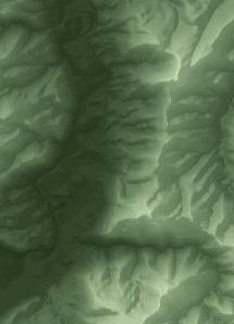
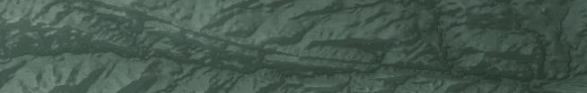
2 324 C.S. PAINTER ET AL. JSR FIG. 1. The Sego Sandstone is a member of Mancos Shale of the Mesaverde Group and is the eastern equivalent of the Upper Castlegate Sandstone. (Modified from Fouch et al and Obradovich 1993) investigate how sequence boundaries and depositional environments correlate along strike, providing a predictive scheme. We document a fourteen-kilometer (along depositional dip) exposure of the Sego Sandstone Member north of Rangely, Colorado, and reconstruct its stratigraphic architecture (Figs. 4, 5). The three dimensionality of the exposures and the facies variability allows a detailed investigation of different depositional environments within the study area. Three sequence boundaries are interpreted, which are consistent, but not demonstrably correlative, with observations in the Book Cliffs area in Utah (Willis 2000). However, the Sego Sandstone Member in the study area records an up-section evolution of depositional environments, which differs from what has been interpreted in the Book Cliffs. The investigated outcrops indicate a prodelta to delta-front environment in the first sequence. This is followed by a period of incision forming an eighteen-meter-deep valley, which is filled with distributary-channel deposits and overlain by stacked tidal bars. Above this, an aggradational succession follows which contains wave-dominated shoreface sandstones, barrier-island sandstones, flood-tidal deltas, and lagoonal mudstone. Following this period of aggradation, an upper incised valley indicates a third sequence boundary, which is filled with sandstones representing a distributary-mouth system. Whereas flood-tidal-delta and barrier-island deposits characterize a significant portion of the study area, similar facies are not as pervasive as in the Book Cliffs (Van Wagoner 1991; Willis 2000; Willis and Gabel 2001, 2003; Wood 2004). These changes in facies along strike indicate variations in depositional environment related to paleogeography and the relative control of wave versus tidal action. An FIG. 2. The study area is located on the western margin of the Cretaceous Interior Seaway, in what is now northwestern Colorado, indicated with the black rectangle (modified from Roberts and Kirshbaum 1995; Willis and Gabel 2003).
3 JSR SEQUENCE STRATIGRAPHY OF THE UPPER CRETACEOUS SEGO SANDSTONE 325 FIG. 3. The study area in relation to regional structural features (modified from Mederos et al. 2005). understanding of these changes is necessary to better understand the controls on such variations and develop better predictive capabilities for oil and gas exploration. Flood-tidal deltas characteristic of the Sego Sandstone Member (York et al. 2011), although relatively small, are potential stratigraphic traps and can be good reservoir plays (Barwis and Hayes 1979; Barwis 1990; Wood 2004). BACKGROUND The Sego Sandstone Member was deposited on the western margin of the Cretaceous Western Interior Seaway and is a member of the Mesaverde Group (Warner 1964) (Figs. 1, 2). Whereas the coeval stratigraphy west of Green River, Utah is composed of the Upper Castlegate Sandstone, its basinward correlatives in the study area are the Buck Tongue and the Sego Sandstone Member (Van Wagoner 1991, 1995; Miall 1993; Willis 2000; Miall and Arush 2001) (Fig 1). Chronostratigraphic analyses of the Sego Sandstone Member in the Book Cliffs area by Gill and Hail (1975) report Baculites perplexus in the Buck Tongue of the Mancos Shale Formation and Baculites scotti in the Anchor Mine Tongue, in Prairie Canyon, located in western Colorado in the Book Cliffs area. The Buck Tongue of the Mancos Shale underlies the Sego Sandstone Member, and the Anchor Mine Tongue divides the lower and upper parts of the Sego Sandstone Member up-section. This places the deposition of the Sego Sandstone in the Book Cliffs area sometime between, 77 Ma and 75.5 Ma (Gill and Hail 1975; Obradovich 1993; Izett et al. 1998; Cobban et al. 2006). Correlations made in the early studies of the Sego Sandstone Member near Rangely, Colorado, are based on lithostratigraphy and facies associations. Early maps of this area and its surrounding geology identify the Castlegate Sandstone, the Buck Tongue, the Sego Sandstone Member, and the overlying Illes and Williams Fork formations (Cullins 1968, 1969, 1971; Barnum and Garrigues 1980). Baculites perplexus has been identified in the Buck Tongue of the Mancos Shale near and west of Rangely, Colorado (Cullins 1971; Molenaar and Wilson 1993), indicating that it is coeval with the Buck Tongue in the Book Cliffs area (Gill and Hail 1975). To date, no ammonite zones have been documented in the Anchor Mine Tongue in this study area. However, a detrital-zircon U-Pb study on the Sego Sandstone Member in the study area reports a maximum depositional age of Ma (York 2010), which is contemporaneous with Baculites scotti (Gill and Hail 1975; Obradovich 1993; Izett et al. 1998; Cobban et al. 2006). It must be noted that there was only one zircon out of 100 dated zircons that recorded that age, and that this is a maximum depositional age. Based on existing, limited chronostratigraphic data, the Sego Sandstone Member in the study area appears to be coeval with the Sego Sandstone Member in the Book Cliffs area. Extensive research has been done on the type sections of the Castlegate Sandstone and Sego Sandstone members in the Book Cliffs area in Utah and Colorado, where they have been interpreted as alluvial deposits, stacked incised-valley fills, and tide-dominated deltas (Fouch et al. 1983; Lawton 1986; Van Wagoner 1991; Miall 1993; Olsen et al. 1995; Van Wagoner 1995, 1998; Yoshida et al. 1998; Robinson and Slingerland 1998; Willis 2000; Miall and Arush 2001; Willis and Gabel 2001, 2003; Wood 2004; among others). The focus of Van Wagoner (1991) was to identify sequence boundaries, outline criteria for recognizing them in the rock record, document the geometry of incised valleys, and describe the character of incised-valley fill and transgressive and highstand system tracts. Van Wagoner (1991) identified nine high-frequency sequence boundaries in the Sego Sandstone Member, six in the lower Sego Sandstone, plus one in the Anchor Mine Tongue and two in the upper Sego Sandstone. Van Wagoner (1991) subdivided each of these nine sequences into lowstand, transgressive, and highstand system tracts, assigning most of the tidal deposits to the lowstand system tracts, also noting that orientations of incised valleys and tidal bars in the Sego Sandstone Member in the Book Cliffs typically trend to the south, southwest, and southeast. In contrast to the nine sequence boundaries reported by Van Wagoner (1991), Willis (2000) reported four sequence boundaries in the Sego Sandstone Member: one high-order sequence boundary at the base of the Sego Sandstone Member and three more nested low-order sequence boundaries higher in the Sego Sandstone Member. Willis and Gabel (2001) instead focus on describing the facies and geometries of what they interpret as three forward-stepping and then backward-stepping tide-dominated deltas. Furthermore, while recognizing that some of the channelized incisions could be incised valleys, they interpret that most are probably deeply cut tidal channels (Willis and


, Wood")


 instead")


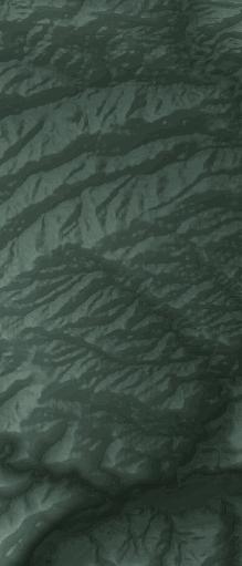


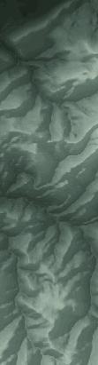


4 326 C.S. PAINTER ET AL. JSR FIG. 4. The geology of the study area overlying a digital elevation model. Our study area is located just north of Rangely, Colorado. The Sego Sandstone outcrops trend northwest along the northern limb of the Rangely anticline. The line A A9 indicates the area of the measured section and the cross section. Gabel 2001, 2003). Similarly to Willis (2000), Wood (2004) reports four sequence boundaries. Aschoff and Steel (2011) report up to three sequence boundaries in the Sego Sandstone Member; however, their study focuses on a much larger scale, both spatially and temporally, with respect to others work (Van Wagoner 1991; Willis and Gabel 2001, 2003; Wood 2004). Based on existing work, apparent discrepancies exist in the sequence stratigraphic interpretation of the Sego Sandstone Member and in its strongly progradational nature. Some attribute progradational and retrogradational episodes to the relative rise and fall of base level without resolving the cause as eustatic or tectonic in nature (Van Wagoner 1991; Willis and Gabel 2001, 2003; Wood 2004). Willis (2000) and Aschoff and Steel (2011) instead attribute the progradational pattern of the Sego Sandstone Member to a tectonic control. Willis (2000) uses the two-phase stratigraphic model of Heller et al. (1988) to explain the high-order sequence boundaries. Heller et al. (1988) proposed that an inactive thrust belt will cause flexural rebound in the orogen, and proximal coarse grained sediment will subsequently be reworked into the distal foreland basin. However, the cause of low-order sequence boundaries is more ambiguous (Willis 2000). A different tectonic driver for the rapid progradation of the Sego Sandstone Member is prescribed by Aschoff and Steel (2011), who propose that the early onset of the Laramide-style deformation and the uplift of the basement-cored San Rafael Swell disrupted the flexural foreland basin, thus reducing accommodation space. As outlined, there is a wide spectrum of interpretations about the controls on the sequence stratigraphy of the Sego Sandstone Member. In contrast, a consensus exists that a large component of the Sego Sandstone Member is tide-influenced to tide-dominated (Van Wagoner 1991; Willis 2000; Willis and Gabel 2001, 2003; Wood 2004; Aschoff and Steel 2011). Regionally the study area and its surroundings are divided into the Uinta Basin and the Piceance Basin (Fig. 3). Whereas the Sego Sandstone
5 JSR SEQUENCE STRATIGRAPHY OF THE UPPER CRETACEOUS SEGO SANDSTONE 327 Member in the Book Cliffs is located in the Uinta Basin (Yoshida et al. 1996; Willis and Gabel 2001, 2003), the Sego Sandstone Member north of Rangely is located along the axis of the Douglas Creek Arch. The Douglas Creek Arch is a southern extension of the Rock Springs uplift and separates the Uinta Basin from the Piceance Basin (Fig. 3). Both the Douglas Creek Arch and the Rock Springs uplift are Laramide structures that simultaneously developed as broad arches during the Late Cretaceous and continued to grow into more discrete uplifts in the Eocene (Bader 2009; Mederos et al. 2005). North and south of Rangely the Mancos Shale, Buck Tongue, and the Castlegate and Sego Sandstone members are exposed on the limbs of the east west-trending Rangely anticline, which is a surficial expression of the underlying, Douglas Creek Arch (Bader 2009) (Fig. 4). North of Rangely, Colorado, the Lower Castlegate Sandstone is overlain by the Buck Tongue, which represents an open marine environment. The Sego Sandstone Member lies erosionally on the Buck Tongue and has been interpreted as barrier-island systems by Stancliffe (1984) in the northwest portion of the study area. A more recent investigation (York et al. 2011) documents flood-tidal-delta deposits northwest of Rangely, whereas just south of Rangely the same member was interpreted as shoreline deposits (Noe 1984). All of these interpretations are quite different from the current interpretation of the Sego Sandstone Member in the Book Cliffs area. SEDIMENTOLOGICAL AND STRATIGRAPHIC ANALYSIS OF THE SEGO SANDSTONE MEMBER Thirty-six detailed log sections in the Sego Sandstone Member, measured at the 1:200 and 1:100 scale with a Jacob s staff, in northwestern Colorado form the basis of the facies analysis described below (Fig. 4). Detailed paleocurrent measurements, conducted by measuring the orientation of the trough axis in trough cross-beds, were taken in three selected facies and are described below. A maximum of approximately seventy meters of detailed Sego Sandstone Member stratigraphy has been measured in the study area. This matches regional thickness documented for the Sego Sandstone Member in the Book Cliffs area (Van Wagoner 1991). In the following section we describe and analyze facies within the three identified sequences and interpret the depositional environment. Regionally mappable surfaces that are incisional and place shallower facies on top of deeper facies, which otherwise would not be found in stratigraphic succession, are identified as sequence boundaries. In this study, we use the following definition for stratigraphic sequence: a relatively conformable succession of genetically related strata bounded by unconformities (Mitchum 1977). Mappable surfaces that place significantly deeper facies on top of shallower ones are classified as flooding surfaces (Posamentier and Vail 1988; Van Wagoner et al. 1988; Van Wagoner et al. 1990; Neal and Abreu 2009). In order to provide a full stratigraphic framework we also describe the underlying Buck Tongue. Three sequence boundaries have been interpreted and are numbered as 1, 2, and 3 from bottom to top of the succession. Each facies within a sequence is assigned a letter combination that stands for its distinguishing characteristics and a number that refers to its relative stratigraphic position above the underlying sequence boundary (e.g., lfrb- 1, hcs-2, mtcs-3). The Buck Tongue of the Mancos Shale consists mostly of black shales in highly weathered slopes and as a result the facies have been generalized. No number letter designation has been assigned. All facies are organized and briefly outlined in Table 1. The Buck Tongue The Buck Tongue of the Mancos Shale overlies the Castlegate Sandstone within the study area. It is a slope-forming, black, organicrich shale, approximately 25 m thick, with little to no silt. Bed forms and sedimentary structures are conspicuously absent from the Buck Tongue. The contact with the overlying sandstones is sharp (Fig. 6). Sego Sandstone Member: Sequence 1 Facies Assemblage A Lower-fine-grained, rippled, and bioturbated sandstone facies (lfrb-1): Facies lfrb-1 is an upper-very-fine- to upper-fine-grained (predominantly lower-fine-grained), tan to reddish (oxidized) sandstone (Fig. 5). Sedimentary structures are difficult to identify because of intense bioturbation. Where sedimentary structures are identifiable, they consist of current ripples to wave-modified ripples with occasional small trough cross-beds. Bioturbation is so extensive that specific ichnofossils are not distinguishable. The total thickness of this unit is 2 to 4.5 meters. Its contact with the underlying Buck Tongue is sharp and erosional (Fig. 6) (Table 1). Lower-fine-grained flaser-bedded to cross-bedded sandstone facies (lffc-1): Laterally, facies lfrb-1 transitions into facies lffc-1, which is a lower-fine-grained sandstone with flaser bedding and current ripples near the base that grade into trough cross beds (Fig. 5). The degree of bioturbation is low, but occasionally Ophiomorpha and Schaubcylindrichnus can be found. Its thickness is 4 to 5 meters, and its contact with the underlying Buck Tongue is sharp and erosional (Table 1). Fifty-four paleocurrent measurements were taken. These paleocurrents are polydirectional, trending west east and southwest northeast (Fig. 7A). Planar to rippled sandstone facies (prs-1): Facies prs-1 crops out farther to the east and southeast, down depositional dip from lfrb-1 and lffc-1. It is composed of bedsets, stacked 0.5 to 1.5 meters thick, consisting of lower-fine- to upper-very-fine-grained sandstones with intercalated shale and mud layers. The sandstones within these bedsets grade normally from lower-fine- to upper-very-fine-grained sand, and from massive to subtly planar-bedding into laminated-bedding, wave-modified current ripples and wavy silty mudstone. This sequence is repeated in bedsets 0.5 to 1.5 meters thick for a total thickness of 5 to 15 meters. Ophiomorpha are common in this facies assemblage, and often the burrow extends the height of a bedset (Figs. 5, 8A, B) (Table 1). Silty shale facies (ssh-1): Facies ssh-1 overlies lfrb-1, lffc-1, and prs-1 and is a dark gray to variegated gray, silty to sandy shale 8 to 12 meters thick (Fig. 5). Where a clean outcrop can be examined, bioturbation is moderate to high, including Planolites, Thalassinoides, and Schaubcylindrichnus (Table 1). The contact with facies lfrb-1, lffc-1, and prs-1 is abrupt. Sego Sandstone Member: Sequence 2 Facies Assemblage B Carbonaceous shale facies (csh-2): On top of facies ssh-1 is a laterally extensive carbonaceous shale to coaly shale. Where present, its thickness increases and decreases, ranging from 1 to 5 centimeters (Table 1). Massive to cross-bedded sandstone facies (mcrss-2): An upper-finegrained, massive to cross-bedded, tan to reddish (oxidized), 18-m-thick sandstone constitutes facies mcrss-2. Individual bedsets are 3 to 10 meters thick. At the base of the cross-beds there is ground organic material, wood, and large (1 10 cm in diameter) mud rip-up clasts. This facies is limited in its extent. Its contact with the underlying prs-1 facies is represented by an erosional unconformity, with an 18-m-deep incision. Multiple stories of this facies are stacked on top of each other to form an 18-meter-thick succession at the deepest part of the incision, which thins laterally to less than 1 meter (Figs. 5, 8C, 9). In the deepest part of the incision, individual stories are 5 to 7 meters thick (Table 1). Twenty paleocurrent measurements were taken by measuring threedimensional cross-beds, where available. These paleocurrents are dominantly southeast directed (Fig. 7C). Facies mcrss-2 is laterally juxtaposed with facies csh-2.
6 328 C.S. PAINTER ET AL. JSR TABLE 1. A brief description of the facies and the interpretation of those facies of the Sego Sandstone Member in the study area. Facies Table Facies Name Brief Description (see text for a more detailed description) Interpretation Assemblage A Prograding delta front lfrb-1 Lower-fine-grained rippled and bioturbated sandstone upper-very-fine- to upper-fine-grained Margins of a delta front. (predominantly-lower-fine-grained), tan to oxidized sandstone. The total thickness of this unit is 2 to 4.5 meters with heavy bioturbation, making it difficult to identify sedimentary structures and individual beds. Where sedimentary structures are identifiable, they are constituted by current ripples to wave-modified ripples with occasional, small trough-cross beds. lffc-1 Lower-fine-grained sandstone with flaser bedding and current ripples near the base that grade into Delta front. trough cross beds. The degree of bioturbation is low, but there are occasional Ophiomorpha and Schaubcylindrichnus. Its thickness is 4 to 5 meters, and its contact with the underlying Buck Tongue is sharp and erosional. prs-1 Bouma beds. Stacked 0.5 to 1.5-meter-thick bedsets composed of lower-fine- to upper-very-fine-grained sandstones with intercalated shale and mud layers. The sandstones within these bedsets grade normally from lower-fine- to upper-very-fine-grained sand and also grade from massive to subtly planar bedding Shallow-water turbidites (i.e., collapsing margin of prograding delta). into laminated bedding into wave-modified current ripples into wavy silty mudstone. ssh-1 Dark gray to variegated gray, silty to sandy shale 8 to 12 meters thick. Inner-shelf mudstones Assemblage B Incised-valley fill csh-2 Laterally extensive carbonaceous shale to coaly shale. mcrss-2 Massive to cross-bedded sandstone upper-fine-grained, massive to cross-bedded, tan to oxidized, sandstone 18 meters thick. Individual bedsets are 3 to 10 meters thick. At the base of the cross beds Incised valley filled with distributary channel there is ground organic material, wood, and large mud rip-ups. lffc-2 Lower-fine-grained sandstone with flaser bedding and current ripples near the base and grade into Delta front trough cross beds up-section. lfrf-2 Lower-fine-grained, rippled to lenticular to flaser-bedded sandstone with low to moderate degree of Tidal bars bioturbation (Planolites). Synaeresis cracks are present, and the thickness of this facies varies from 1 to 5 meters with broad clinoforms and an elongate and lobate geometry. om-2 Dark brown to black, slope-forming, organic rich mudstone. Estuarine muds Assemblage C Barrier islands and flood tidal deltas hcs-2 Slightly coarsening-upward, very-fine- to upper-very fine-grained, hummocky cross-stratified sandstone. Lower-shoreface deposits and lower shoreface in barrier-island deposits. tcs-2 Upper-very-fine- to lower-fine-grained trough cross-stratified sandstones with a low degree of bioturbation Upper shoreface consisting of Ophimorpha and Skolithos. pcs-2 Upper-very-fine- to lower-fine-grained planar cross-stratified sandstones with a low degree of bioturbation Foreshore consisting of Ophimorpha and Skolithos. rb-2 Rippled and bioturbated. Thin-bedded, upper-very-fine- to lower-fine-grained, rippled to flaser shaly Tidal flats sandstone to sandstone with high degree of bioturbation and occasional root traces compose facies. csh-c-2 Less than 5 cm to 10 cm carbonaceous shale to coal. Where it is a coal, this facies is easily visible, Swamp and coastal-plain deposits whereas when it is composed of carbonaceous shale it is often poorly exposed. ssh-oys-2 Silty shale with oysters. 1 to 5 meters of slope-forming, gray, silty, thin-bedded shale. Finely ground Lagoonal mudstones and reworked organic matter is present throughout this facies, and isolated sandy ledges of oyster hash are found in several places within this facies. tcs-dmd-2 Trough cross stratification with sporadic double mud drapes. Lower-fine- to upper-fine-grained Flood tidal delta sandstone 3 to 6 meters thick. The predominant sedimentary structure is trough cross-beds, but there are also rippled horizons and occasional mud drapes. Furthermore, double mud drapes are present in this facies. ssh-2 Dark gray to variegated gray, silty to sandy shale 5 to 20 meters thick. Inner-shelf mudstones Assemblage D Distributary channel mtcs-3 Upper-fine- to lower-medium-grained, trough cross-bedded, to lenticular sandstone. The lower portion contains ground organic woody material, mud rip ups, and occasionally oyster hash and bone fragments. Its thickness varies from 8 to 16 meters, and its base is highly erosional. Distributary-mouth system Lower-fine-grained flaser-bedded to trough cross-bedded sandstone facies (lffc-2): Facies mcrss-2 passes down dip into a lower-fine-grained sandstone with flaser bedding and current ripples near the base, which grade into trough cross-beds up-section. The degree of bioturbation is moderate, with Ophiomorpha and Schaubcylindrichnus. The lower contact of this facies is abrupt with the underlying facies ssh- 1 and in places lies unconformably on top of facies prs-1 (Table 1). Lower-fine-grained rippled to flaser-bedded sandstone facies (lfrf-2): Facies lfrf-2 is a lower-fine-grained, rippled to lenticular-bedded to flaserbedded sandstone with a low to moderate degree of bioturbation (Planolites). Synaeresis cracks are present, and the thickness of this facies varies from 1 to 5 meters with broad clinoforms, approximately 3 meters high, and an elongate and lenticular geometry (Table 1). Organic mudstone facies (om-2): Dark brown to black, slope-forming, organic-rich mudstone are exposed at various stratigraphic levels in Sequence 2. They are found interbedded with and overlying facies lfrf-2 (Table 1). Facies Assemblage C Hummocky cross-stratified sandstone facies (hcs-2): Facies hcs-2 is a slightly coarsening-upward, very fine- to upper-very-fine-grained, hummocky cross-stratified sandstone (Fig. 8E). This facies has a low degree of
.")
7 JSR SEQUENCE STRATIGRAPHY OF THE UPPER CRETACEOUS SEGO SANDSTONE 329 intensity is moderate to high, including Planolites, Thalassinoides, and Schaubcylindrichnus. The contact with facies lffc-2, mcrss-2, and hcs-2 is abrupt (Table 1). Sego Sandstone Member: Sequence 3 Facies Assemblage D Medium-grained, trough cross-bedded facies (mtcs-3): Facies mtcs-3 is an upper fine- to lower-medium-grained, trough cross-bedded, to lenticular sandstone. The lower portion contains ground carbonaceous material, mud rip-up clasts, and occasionally oyster hash and bone fragments. Its thickness varies from 8 to 16 meters, and its base is highly erosional (Figs. 8I, J, 10) (Table 1). In places it overlies facies om-2, whereas in other locations it is unconformable on top of csh-c-2. In two documented locations this facies has eroded through multiple stratigraphic horizons of more basinward facies and rests on top of facies rb-2 (Figs. 5, 8I, J). INTERPRETATIONS OF THE SEGO SANDSTONE MEMBER FIG. 6. The Sego Sandstone in contact with the underlying Buck Tongue. The contact is sharp, placing upper-fine-grained sand on black marine shale. The Jacob s Staff offers scale with 10 cm divisions. bioturbation, and when bioturbation is present it consists of Ophiomorpha. Gutter casts occur at the base of the hummocky cross-stratified sandstone beds, with some interbedded mudstone. The thickness of this interval varies from 1 to 4.5 meters (Table 1). Trough cross-bedded sandstone facies (tcs-2): Conformably above facies hcs-2 are upper-very-fine- to lower-fine-grained trough crossstratified sandstones with a low degree of bioturbation consisting of Ophiomorpha and Skolithos (Table 1). Planar cross-stratified sandstone facies (pcs-2): Low-angle and laminated, lower-fine-grained sandstone is found on top of facies tcs-2. In places, this facies has a rooted top and, where overlain by a coal, a poorly developed paleosol. The thickness of this facies is less than 1 meter (Table 1). Rippled and bioturbated sandstone facies (rb-2): Thin-bedded, uppervery-fine- to lower-fine-grained, rippled to flaser-bedded shaly sandstone to sandstone with high degree of bioturbation and occasional root traces constitutes facies rb-2. The total thickness of this facies is 3 to 4 meters and is found, regionally, in the updip direction of facies lfrf-2 and pcs-2 facies (Fig. 5) (Table 1). Carbonaceous shale to coal facies (csh-c-2): Overlying facies tcs-2 and pcs-2 is often facies rb-2, which is composed of a less than 5 cm to 10 cm carbonaceous shale to coal (Table 1). Where it is composed of coal, this facies is easily visible, whereas where it is composed of carbonaceous shale it is often poorly exposed (Fig. 8G). Silty shale with sporadic oyster-hash facies (ssh-oys-2): Facies ssh-oys-2 consists of a 1 to 5 meters of slope-forming, gray, silty, thin-bedded shale. Finely ground and reworked organic matter is present throughout this facies, and isolated sandy ledges of oyster hash are found in several places within this facies (Table 1). This facies overlies facies tcs-2, pcs-2, and lfrf-2 (Fig. 5). Trough cross-beds with double mud drapes facies (tcs-dmd-2): Facies tcs-dmd-2 is a white, lower-fine- to upper-fine-grained sandstone 3 to 6 meters thick. The predominant sedimentary structure is trough crossbeds and occasional rippled horizons and mud drapes. Furthermore, double mud drapes are present in this facies. Bioturbation is minimal, and where present consists of Ophiomorpha. Reactivation surfaces and sigmoidal bedding are also present (Table 1). Facies tcs-dmd-2 is relatively laterally constrained, approximately 1.2 km along dip, and is lenticular in geometry (Fig. 7H). Silty shale facies (ssh-2): Facies ssh-2 overlies lffc-2, mcrss-2, and hcs-2 and is dark gray to variegated gray, silty to sandy shale 5 to 20 meters thick (Fig. 5). Where a clean outcrop can be examined, bioturbation Facies Interpretations Interpretation of the Buck Tongue. The lack of bed forms and sedimentary structures indicates pervasive bioturbation (i.e., a high bioturbation index), which is generally associated with low sedimentation rates and stable physicochemical parameters commonly found in open marine, mid-shelfal to outer-shelfal environments (MacEachern et al. 2010). This interpretation is also supported by ammonite fossils found near the study area and in other areas where the Buck Tongue crops out (Cullins 1971; Gill and Hail 1975; Molenaar and Wilson 1993). Interpretation of Sequence 1: Delta Front. As a whole, Sequence 1 is interpreted as a delta-front assemblage, characterized by facies lfrb-1, lffc- 1, prs-1, that was later flooded, placing inner-shelfal to mid-shelfal muds on top, characterized by facies ssh-1. Given the high degree of bioturbation, and its lateral proximity to lffc-1, a rippled, flaser-bedded and cross-bedded sandstone, facies lfrb-1 is interpreted as the low-energy margins of the delta front of an advancing lobe (Hori et al. 2001). Lffc-1 was deposited in moderate- to high-energy regimes subject to currents from multiple directions represented by the trough cross-beds and polydirectional paleocurrents (Fig. 7A). Its sharp basal contact supports the interpretation that this facies represents part of the uppermost part of a delta front that was deposited subaqueously, above fair-weather wave base, and exposed to longshore currents and tides. Within facies prs-1, the normal grading from massive to laminated to rippled sandstone to mudstone is consistent with units A, B, C, and E of the Bouma sequence (Bouma 1962). Unit D of the Bouma sequence is missing; however, horizon D is seldom preserved in the rock record in general (Hsü 1989). This facies is interpreted as shallow-water turbidites produced on the unstable front of an advancing delta or by hyperpycnal flow during flooding events in the fluvial system landward (Bates 1953; Fisher et al. 1969; Enge et al. 2010a, 2010b). Ssh-1 is interpreted as the result of waning energy conditions leading to deposition of the lower-energy silty shale on top of lower fine sandstones. The relatively low-energy depositional environment and relatively high bioturbation suggest that these strata were deposited as inner-shelf mudstones (Hobday and Morton 1984). This facies represents a deeper-water depositional environment than facies lfrb-1, lffc-1, and prs-1, and therefore the lower contact with the underlying strata is interpreted as a flooding surface. Interpretation of Sequence 2: Distributary Channel, Stacked Tidal Bars, Flood-Tidal Deltas, and Barrier Islands. Csh-2 is a carbonaceous shale and in some places a coaly shale, and it overlies ssh-1, a shale that is interpreted as an open marine, mid- to inner-shelfal shale. The amount of
8 330 C.S. PAINTER ET AL. JSR FIG. 7. Cartoons that outline the evolution of the Sego Sandstone in our study area with paleocurrents shown for selected horizons. carbonaceous material in csh-2 indicates a much more proximal environment of deposition. Where csh-2 is a coaly shale, it was deposited in a subaerial to nearly subaerial environment. The surface between ssh-1 and csh-2 is interpreted as a sequence boundary (Sequence Boundary 2). The interpretation of a sequence boundary is supported by the fact that this surface is laterally extensive and that downdip ssh-1 (a marine shale deposit) is juxtaposed against incision-filling sandstone that is described in the following section. These incisions are cut into facies prs-1, which represents a low-energy, inner-shelf, silty mudstone. Facies mcrss-2, a massive to cross-bedded sandstone with rip-up clasts and large organic debris, occupies the incision of Sequence Boundary 2 and is interpreted as an incised-valley fill (Fig. 11). Twenty paleocurrents measurements in the upper portion of mcrss-2 have an overall southeast direction (Fig. 7C), which is perpendicular to the southwest northeast orientation proposed for the shoreline (Stancliffe 1984). Depositionally updip of the incised-valley fill, facies lfrf-2 overlies csh-2 and comprises bar forms, which are often stacked on top of one another (Figs. 5, 8D). Laterally, these bar forms pinch out into highly organic-rich mudstone and generally overlie the csh-2 facies. Based on the flaser and sigmoidal cross beds, synaeresis cracks, bar-form geometry, and lateral relationships we interpret this facies to represent stacked tidal bars, deposited in an estuarine environment (Plummer and Gostin 1981; Thomas et al. 1987). Facies om-2 is interpreted to have been deposited in the central basin area of an estuarine system as described by Dalrymple et al. (1992). This is where the estuary was deepest and was starved of both marine and riverine sand. Facies hcs-2 crops out at multiple stratigraphic levels and is interpreted as distal lower shoreface to lower shoreface (Dumas et al. 2005; Dumas and Arnott 2006) (Figs. 5, 8E). In the updip (northwestern) area the hcs-2 often is part of a coarsening-upward shoreface succession with trough cross-beds (facies tcs-2) with a transition into low-angle cross-stratification that is interpreted as high flow regime and that represents uppershoreface deposits (facies pcs-2) (Reinson 1984). In places the top of pcs-2 is rooted. Where this is the case it is interpreted as foreshore and berm deposits (Figs. 5, 8F, G). Overlying the upward-coarsening shoreface
 facies prs-1, C) mcrss-2, D) lfrf-2, E) hcs-2, F) rooted tcs-2, G) csh-c-2, H)")
9 JSR SEQUENCE STRATIGRAPHY OF THE UPPER CRETACEOUS SEGO SANDSTONE 331 FIG. 8. Photographs of A, B) facies prs-1, C) mcrss-2, D) lfrf-2, E) hcs-2, F) rooted tcs-2, G) csh-c-2, H) tcs-dmd-2, and I, J) mtcs-3.


10 332 C.S. PAINTER ET AL. JSR this interpretation: facies tcs-dmd-2 pinches out landward into facies csh-c-2, which represents a lagoonal, back-barrier mudstone; facies tcsdmd-2 is juxtaposed seaward with facies hcs-2 and tcs-2, which are lowerand upper-shoreface sandstones interpreted to represent a preserved barrier island. The thin-bedded, upper-very-fine- to lower-fine-grained, rippled to flaser-bedded shaly sandstone to sandstone with a high degree of bioturbation and occasional root traces that characterizes facies rb-2 are interpreted as tidal-flat deposits (Kumar and Sanders 1974). Interfingering sandstones and shales in Sequence 2, ssh-2, is the result of waning energy conditions leading to deposition of the lower-energy silty shale on top of lower-fine-grained sandstones. Because of the relatively low energy and relatively high degree of bioturbation we interpret this facies as inner-shelf mudstones (Hobday and Morton 1984). Also, because this facies represents a deeper-water depositional environment than facies mcrss-2 and lffc-2, the lower contact with the underlying strata is interpreted as a flooding surface. FIG. 9. Erosional base of facies lffc-2 in an area where it is, 1 m thick. Photo taken northeast of section 28 (Figs. 4, 5). succession are often the csh-c-2 facies, a coal, and ssh-oys-2 facies, a silty shale with sporadic oyster beds. Facies csh-c-2 is interpreted to have been deposited in a swamp to coastal-plain environment, as expected in case of a complete, upward-coarsening and prograding shoreface succession. Because of the interpreted low energy, occurrence of oyster shell hash, thin beds, and the presence of organic material of facies ssh-oys-2, this facies is interpreted as a lagoonal, back-barrier mudstone. Barrier shoreface sandstones are found down dip of this facies, supporting this interpretation. Facies tcs-dmd-2 has been the focus of recent detailed research indicating flood-tidal-delta affinity. Paleocurrents indicate a bidirectional pattern with a significant landward component (York et al. 2011). Given the tidal indicators, such as bidirectional cross-beds, sigmoidal bedding, and double mud drapes, we interpret this facies to represent a flood tidal delta, in agreement with York et al. (2011). Furthermore, the following stratigraphic relationship further supports Interpretation of Sequence 3: Distributary Channel. The upper-fine- to lower-medium-grained, trough cross-bedded to lenticular sandstone, mtcs-3 is interpreted as distributary-channel and mouth system deposits, filling an incised valley. The lower portion contains ground organic woody material, mud rip-up clasts, and occasionally oyster hash and bone fragments. Its thickness varies from 8 to 16 meters, and its base is highly erosional (Fig. 10). Its basal contact is erosional in the northwest portion of the study area and sharp in the southeast portion of the study area. This basal surface is interpreted as a sequence boundary. Sequence Stratigraphic Surfaces The following summary is a more detailed explanation of why the surfaces that are documented in this study are interpreted as sequence boundaries and flooding surfaces, using the definitions set forth in the literature (Mitchum 1977; Posamentier and Vail 1988; Van Wagoner et al. 1988; Van Wagoner et al. 1990; Neal and Abreu 2009). Flooding surfaces have been identified in each of these sequences, and they are identified with two numbers; the first represents which sequence the surface is found in, and the second is the number of the flooding surface in that sequence. FIG. 10. The white dashed line marks Sequence Boundary 3 and the base of facies mtcs-3. This photo was taken across a draw to capture the erosional base of facies mtcs-3. Photo taken between sections 12 and 13 (Figs. 4, 5).


11 JSR SEQUENCE STRATIGRAPHY OF THE UPPER CRETACEOUS SEGO SANDSTONE 333 FIG. 11. Incised-valley fill overlying Sequence Boundary 2. Photo taken just east of section 28 (Figs. 4, 5). For example, the first flooding surface to appear above Sequence Boundary 1 is identified as flooding surface 1-1, whereas the second flooding surface to appear above Sequence Boundary 2 is identified as flooding surface 2-2. Minor flooding surfaces in largely aggradational strata were not numbered; we consider a minor flooding surface to be where less than two facies are missing across the flooding surface, for example, marginal marine shale deposited on top of hummocky crossstratified sandstone. FIG. 12. Detailed view of section 15 (Nate Springs Draw) (Figs. 4, 5) with a corresponding photo. All three sequence boundaries are visible.
. Sequence Boundary 1. Sequence Boundary 1 marks the base of the Sego Sandstone and the top of the Buck Tongue.")
12 334 C.S. PAINTER ET AL. JSR FIG. 13. Detailed view of section 9 (Amphitheater) with a corresponding photo. Sequence Boundaries 2 and 3 are visible. Note the tidal bar between SB 2 and FS 2-1 that pinches out into organic mudstone (om-2). Sequence Boundary 1. Sequence Boundary 1 marks the base of the Sego Sandstone and the top of the Buck Tongue. The base of the Sego Sandstone Member consists of facies lfrb-1, lffc-1, and prs-1, which have been interpreted as a delta-front assemblage and include the low-energy margins of the delta front, the advancing body of the delta front, and associated shallow-water turbidites. In the case of facies lffc-1 and prs-1 the contact with the underlying Buck Tongue is sharp, with the upper-fine-grained sandstone overlying the black shale with very little silt (Fig. 6). The surface is regionally mappable, and the combination of the grain-size change and the sharp contact represents a significant basinward shift in facies. These characteristics qualify it as a sequence boundary. Flooding Surface 1-1. Flooding surface 1-1 is recognized by facies ssh- 1, a mid-shelfal shale abruptly overlying the delta-front assemblage below. FS 1-1 is exposed in the northwest portion of the study area, but it has been eroded in the southeast portion of the study area by incision at Sequence Boundary 2 (Figs. 5, 12). Sequence Boundary 2. Sequence Boundary 2 is a highly erosional surface that can be mapped throughout the study area; however, the highest amount of relief within the incision and the most discordant facies juxtaposition is located in the central and northwest portions of the study area (Fig. 5). At its deepest incision, there are eighteen meters of relief, as seen in measured section 28 (Figs. 9, 11). This incised valley is filled with facies mcrss-2 and lffc-2, which have been interpreted as a distributary-mouth facies assemblage, as well as facies lfrf-2 and rb-2, which have been interpreted as stacked tidal bars and tidal flats (Fig. 5). These tide-influenced distributary-mouth deposits overlie the ssh-1 facies in the central to northwest portions of the study area and the delta-front assemblage to the southeast (Fig. 5). Where incisional relief is high, these incised-valley-fill deposits juxtapose and onlap the ssh-1 facies, which is constituted by a mid-shelfal shale. In places, the ssh-1 facies is overlain by the csh-2 facies, a carbonaceous shale that is coaly in places. The incisional nature of the surface with tide-influenced distributary deposits onlapping mid-shelfal shales represents a significant basinward shift in facies and is identified as a sequence boundary. Flooding Surface 2-1. On top of the incised-valley fill there is a consistent deepening of facies. Toward the southeast of the study area this is marked by ssh-2 facies, a marine shale, overlying mcrss-2 and lffc-2 facies, which have been interpreted as a distributary-mouth facies assemblage (Figs. 5, 12, 13, 14). In the northwest portion of the area this surface is represented by ssh-2 and hcs-2 facies, a marine shale and lower-shoreface deposits, overlying lfrf-2 facies, which are stacked tidal bars. In parts of the study area, this surface is also marked by an increased concentration of Ophiomorpha ichnofossils. After the transgression, the system passed from a tide-dominated system into a wavedominated system with a small amount of tide influence, as indicated by the barrier-island and shoreface assemblages with lagoonal and floodtidal-delta deposits landward of them. It also passed into a largely aggradational system.


13 JSR SEQUENCE STRATIGRAPHY OF THE UPPER CRETACEOUS SEGO SANDSTONE 335 FIG. 14. Detailed view of section 34 (White River North) (Figs. 4, 5) with a corresponding photo. Note that ssh-1 is no longer present between the sandstone units of Sequence 1 and Sequence 2. Sequence Boundary 2 incised down to the lffc-1 facies unit, creating a sandstone-on-sandstone contact. Flooding Surface 2-2. Ssh-2, a marine shale, overlies those more proximal flood-tidal-delta and lagoonal deposits found in the northwest portion of the study area (Fig. 5). This transgression marks the base of the Anchor Mine Tongue of the Mancos Shale. Sequence Boundary 3. Sequence Boundary 3 is a regionally mappable incisional surface. Incisional relief is highest, seventeen meters, in the very northwest of the study area, as documented in measured section 1 (Fig. 5). There, facies mtcs-3, a medium-grained distributary sandstone, FIG. 15. Schematic stratigraphic architecture of the Sego Sandstone in the Book Cliffs area as presented by Willis (2000) compared to that of the Sego Sandstone north of Rangely, Colorado. Note the three sequence boundaries in both areas. Also note the absence of flood-tidal-delta and barrier-island deposits in the Sego Sandstone in the Book Cliffs area.
14 336 C.S. PAINTER ET AL. JSR overlies lagoonal shales, facies om-2. Farther down depositional dip, distributary-channel deposits overlie marine shale and lower-shoreface sandstones, facies ssh-2 and hcs-2. In some areas the hcs-2 facies is truncated by the incisional contact. This can be seen between measured sections 3 and 4, 15 and 17, and 26 and 27 (Figs. 5, 10, 12, 13, 14). The highly incisional nature of this surface, its regional extent, and the basinward shift in facies across it are all consistent with a sequenceboundary interpretation. Flooding Surface 3-1. Flooding surface 3-1 represents the top of the Sego Sandstone Member in the study area. The strata above this surface includes the Neslen Formation in the Book Cliffs area (Van Wagoner 1991; Willis 2000; Wood 2004; Aschoff and Steel 2011) and the Illes and Williams Fork formations in the study area (Cullins 1968; Barnum and Garrigues 1980). Where this surface overlies facies mtcs-3, a distributarychannel deposit, an oyster shell hash is commonly present, which is interpreted as a transgressive lag deposit. DISCUSSION AND CONCLUSION FIG. 16. Paleogeographic maps for three phases during Sego Sandstone deposition in Rangely, Colorado, extended to the Book Cliffs area to the west and southwest. Phase I is located at the base of sequence 1 in this study area, Phase II at the top of sequence 2, and Phase III at the base of sequence 3. The paleogeography of those three phases were extrapolated to the Book Cliffs using the interpretations of Wood (2004). Active thrust faults during the late Campanian are shown (DeCelles et al. 1995; DeCelles 2004; Dickinson 2004; Dickinson and Gehrels 2008). The Sego Sandstone Member within the study area shows significant lateral and vertical changes. The lowermost portion is characterized by Sequence Boundary 1, which represents a relative drop in sea level and the progradation of a delta system. Based on northwest to southeast gutter-cast orientation, the general shoreline geometry was southwest to northwest (Stancliffe 1984; Leckie and Krystinik 1989). Fifty-four paleocurrent measurements (Fig. 7A) indicate a southwest to northeast shore-parallel component suggesting a significant amount of wave reworking. The facies recognized in the study area change down dip from rippled and bioturbated sandstone, representing the margins of the delta, to trough cross-bedded sandstone, representing the subaqueous delta front. Farther down dip, these facies pass into event beds produced by turbidity currents, which we interpret as the front and margins of this prograding deltaic system (Fig. 7A). The upper contact of these deposits represents an overall deepening and a flooding surface. In this now lower-energy environment silty to sandy, inner shelf mudstones were deposited (Fig. 7B). This series of facies units constitute Sequence 1. Sequence 2 is marked by an incisional event at its base that placed distributary-channel sandstone and carbonaceous to coaly mudstone on top of inner-shelf mudstone. Paleocurrents from the incised-valley fill show predominately southeast, basinward currents, suggesting that these facies were deposited more up dip within the system and were more strongly affected by river processes (Fig. 7C). Another transgression is represented by a retrogradational succession of stacked tidal bars on top of incised valley fill and coaly mudstone. Lower-shoreface sandstone overlies the stacked tidal bars (Fig. 7D). Above this succession, the system was largely aggradational and is represented by the stacking of multiple shoreface sandstone, barrierisland, lagoonal, and flood-tidal-delta deposits, which were later flooded and capped with another shoreface deposit (Fig. 7E J). This succession of retrogradational to aggradational deposits constitutes Sequence 2. Another incisional surface marks the base of Sequence 3. This incision cuts into the lower-shoreface deposits below and in places removes the underlying lagoonal, barrier-island, and flood-tidal-delta deposits. Sequence Boundary 3 is overlain by a distributary-channel system. The paleocurrents within the distributary channel are bidirectional in nature, indicating a strong tidal component. This distributary system lies at the top of the Sego Sandstone Member in this area (Fig. 7K L). Similarly to the equivalent Sego Sandstone Member deposits in the Book Cliffs, the Sego Sandstone Member in the study area is characterized by three sequence boundaries (Fig. 15) and is heavily influenced by tidal processes as indicated by the pervasiveness of lenticular and flaser bedding, double mud drapes, reactivation surfaces, bidirectional paleocurrents, synaeresis cracks, and low-diversity, stressed
Lab 8: Facies Analysis and Correlations: Sequence Stratigraphy in the Book Cliffs, Utah
 Geology 109L Lab 8: Facies Analysis and Correlations: Sequence Stratigraphy in the Book Cliffs, Utah Goal: In this lab, you will put together your knowledge of near-shore facies and sequence stratigraphy
Depositional Sequences Sequences
 Depositional Sequences Transgressive and Regressive packages can be bound by unconformities Because sediment can only be preserved during net aggradation and progradation All other times there is either
FORMATION OF DEEP INCISIONS INTO TIDE-DOMINATED RIVER DELTAS: IMPLICATIONS FOR THE STRATIGRAPHY OF THE SEGO SANDSTONE, BOOK CLIFFS, UTAH, U.S.A.
 FORMATION OF DEEP INCISIONS INTO TIDE-DOMINATED RIVER DELTAS: IMPLICATIONS FOR THE STRATIGRAPHY OF THE SEGO SANDSTONE, BOOK CLIFFS, UTAH, U.S.A. BRIAN J. WILLIS 1 AND SHARON L. GABEL 2 1 Department of
Facies Analysis Of The Reservoir Rocks In The. Sylhet Trough, Bangladesh. Abstract
 Facies Analysis Of The Reservoir Rocks In The Sylhet Trough, Bangladesh Joyanta Dutta Petroleum Geoscience Program, Department of Geology, Faculty of Science, Chulalongkorn University, Bangkok 10330, Thailand
Accommodation. Tectonics (local to regional) Subsidence Uplift
 Subsidence Uplift") Accommodation Accommodation varies over time; it is the distance between a reference horizon and the sea surface (i.e. relative sea level). The space to be filled in with sediments or water What are the
Accommodation Accommodation varies over time; it is the distance between a reference horizon and the sea surface (i.e. relative sea level). The space to be filled in with sediments or water What are the
Sedimentary and Stratigraphic Analysis of the Viking Sand in the Edgerton/Wainwright Area, Central Alberta* By Russell Walz 1
 Sedimentary and Stratigraphic Analysis of the Viking Sand in the Edgerton/Wainwright Area, Central Alberta* By Russell Walz 1 Search and Discovery Article #50030 (2006) Posted June 25, 2006 *Extended abstract
Journal of Sedimentary Research, 2011, v. 81, 0 0 Research Article DOI: 2110/jsr
 Journal of Sedimentary Research, 2011, v. 81, 0 0 Research Article DOI: 2110/jsr.2011.35 SEDIMENTOLOGICAL CHARACTERIZATION OF THE SEGO SANDSTONE (NW COLORADO, USA): A NEW SCHEME TO RECOGNIZE ANCIENT FLOOD-TIDAL-DELTA
The Impact of Parasequence Stacking Patterns on Vertical Connectivity Between Wave-Dominated, Shallow Marine Parasequences, Book Cliffs, Eastern Utah
 The Impact of Parasequence Stacking Patterns on Vertical Connectivity Between Wave-Dominated, Shallow Marine Parasequences, Book Cliffs, Eastern Utah MALCOLM J. ARNOT and TIMOTHY R. GOOD* MALCOLM J. ARNOT
Bulletin of Earth Sciences of Thailand
 Depositional Environments and Stratigraphic Development of the Grand Taman Sari Circuit Outcrop: an Analogue for Transgressive Mahakam Delta Successions Ridha Santika Riadi Petroleum Geoscience Program,
Effects of Tides on Deltaic Deposition: Causes and Responses*
 Effects of Tides on Deltaic Deposition: Causes and Responses* Piret Plink-Bjorklund 1 Search and Discovery Article #50626 (2012)** Posted June 25, 2012 *Adapted from oral presentation at AAPG Annual Convention
Jesse D. Thompson. Dr. Diane Kamola Chairperson. Dr. Anthony W. Walton. Dr. Ross A. Black. Date defended:
 SEQUENCE STRATIGRAPHY AND FACIES ANALYSIS OF THE ROLLINS SANDSTONE MEMBER (MOUNT GARFIELD FORMATION) AND RE- EXAMINATION OF THE CONTACT BETWEEN THE MOUNT GARFIELD AND WILLIAMS FORK FORMATIONS (LATE CRETACEOUS)
Viking Lowstand Deposits in West Central Saskatchewan: Depositional Model for the Reservoir Units in Dodsland-Hoosier Area, Saskatchewan, Canada
 Viking Lowstand Deposits in West Central Saskatchewan: Depositional Model for the Reservoir Units in Dodsland-Hoosier Area, Saskatchewan, Canada Hasan Ferdous* PetroSed Geoconsulting Resources, Calgary,
A Simplified Guide For Sequence Stratigraphy:
 SEPM Society for Sedimentary Geology A Simplified Guide For Sequence Stratigraphy: Nomenclature, Definitions and Method Vitor Abreu President - SEPM Abstract All attempts to codify Sequence Stratigraphy
Outcrops from Every Continent and 20 Countries in 140 Contributions. Tor H. Nilsen, Roger D. Shew, Gary S. Steffens, and Joseph R.J. Studlick.
 Paper VIII Tor H. Nilsen, Roger D. Shew, Gary S. Steffens, and Joseph R.J. Studlick Editors Outcrops from Every Continent and 20 Countries in 140 Contributions http://bookstore.aapg.org Length ~ 23 m (75.5
David Piper and Atika Karim ABSTRACT
 David Piper and Atika Karim ABSTRACT Hyperpycnal flow deposits, or delta-front turbidites, are becoming increasingly recognised as important components of some deltaic systems. The presence of Bouma Tabce
Introduction to sequence stratigraphy and its application to reservoir geology
 Introduction to sequence stratigraphy and its application to reservoir geology Massimo Zecchin Istituto Nazionale di Oceanografia e di Geofisica Sperimentale - OGS Historical development Definitions Systems
The unknown giants - low-permeability shallow gas reservoirs of southern Alberta and Saskatchewan, Canada.
 The unknown giants - low-permeability shallow gas reservoirs of southern Alberta and Saskatchewan, Canada. Shaun O'Connell* Belfield Resources Inc., Calgary belfield@shaw.ca ABSTRACT The gas reserves contained
High-resolution Sequence Stratigraphy of the Glauconitic Sandstone, Upper Mannville C Pool, Cessford Field: a Record of Evolving Accommodation
 Page No. 069-1 High-resolution Sequence Stratigraphy of the Glauconitic Sandstone, Upper Mannville C Pool, Cessford Field: a Record of Evolving Accommodation Thérèse Lynch* and John Hopkins, Department
Sequence Stratigraphy. Historical Perspective
 Sequence Stratigraphy Historical Perspective Sequence Stratigraphy Sequence Stratigraphy is the subdivision of sedimentary basin fills into genetic packages bounded by unconformities and their correlative
THREE-DIMENSIONAL STRATIGRAPHIC ARCHITECTURE AND EVOLUTION OF AN ANCIENT RIVER-DOMINATED DELTA, ILES FORMATION, BOOK CLIFFS, COLORADO
 THREE-DIMENSIONAL STRATIGRAPHIC ARCHITECTURE AND EVOLUTION OF AN ANCIENT RIVER-DOMINATED DELTA, ILES FORMATION, BOOK CLIFFS, COLORADO by Matthew A. Andresen A thesis submitted to the Faculty and Board
Dakota Sandstone. of the Moxa Arch and Surrounding Green River Basin
 Dakota Sandstone of the Moxa Arch and Surrounding Green River Basin Dakota Sandstones of the Green River Basin Overview The Dakota sandstones of the Moxa Arch and surrounding Green River Basin remain attractive
OUTCROP! CHARACTERISATION! OF! TRANSGRESSIVE! SANDSTONE! RESERVOIRS:! QUANTITATIVE!COMPARISON!OF!OUTCROP!ANALOGUES!
 OUTCROP CHARACTERISATION OF TRANSGRESSIVE SANDSTONE RESERVOIRS: QUANTITATIVECOMPARISONOFOUTCROPANALOGUES OLIVER D. JORDAN 1, PETER J. SIXSMITH 2, GARY J. HAMPSON, SANJEEV GUPTA & HOWARDD.JOHNSON DepartmentofEarthScienceandEngineering,ImperialCollegeLondon,SouthKensington
Sup. Mat. 1. Figure DR1. Map showing the distribution of the Vanrhynsdorp Group. 02
 GSA DATA REPOSITORY 2013142 Buatois, Almond and Germs Treptichnus pedum - List of supplementary materials: Sup. Mat. 1. Figure DR1. Map showing the distribution of the Vanrhynsdorp Group. 02 Sup. Mat.
GeoCanada 2010 Working with the Earth
 Lithofacies Identification and the Implications for SAGD Well Planning in the McMurray Formation, Christina Lake Area, Alberta Travis Shackleton*, Robert Gardner, Sung Youn, Grace Eng and Lori Barth Cenovus
Fluid-Mud Deposits of the Lower Jurassic Tilje Formation, Offshore Mid-Norway By Aitor A. Ichaso and Robert W. Dalrymple 1
 Fluid-Mud Deposits of the Lower Jurassic Tilje Formation, Offshore Mid-Norway By Aitor A. Ichaso and Robert W. Dalrymple 1 Search and Discovery Article #50107 (2008) Posted August 10, 2008 *Adapted from
Facies Analysis of the Lower Cretaceous Wilrich Member (Lower Falher) of the Spirit River Formation.
 of the Spirit River Formation.") Facies Analysis of the Lower Cretaceous Wilrich Member (Lower Falher) of the Spirit River Formation. Kerrie L. Bann, Ichnofacies Analysis Inc. and Daniel J. K. Ross, Tourmaline Oil Corp. Historically,
Facies Analysis of the Lower Cretaceous Wilrich Member (Lower Falher) of the Spirit River Formation. Kerrie L. Bann, Ichnofacies Analysis Inc. and Daniel J. K. Ross, Tourmaline Oil Corp. Historically,
Sequence Stratigraphy as a tool for water resources management in alluvial coastal aquifers: application to the Llobregat delta (Barcelona, Spain)
") Sequence Stratigraphy as a tool for water resources management in alluvial coastal aquifers: application to the Llobregat delta (Barcelona, Spain) Desiré Gàmez Torrent December 2007 CHAPTER 1: Introduction
Sequence Stratigraphy as a tool for water resources management in alluvial coastal aquifers: application to the Llobregat delta (Barcelona, Spain) Desiré Gàmez Torrent December 2007 CHAPTER 1: Introduction
LINGUAU DEPOSITION IN THE WOODBINE SANDS ALONG COPPERAS BRANCH, DENTON COUNTY. TEXAS: A STUDY IN MARINE SEDIMENTATION
 LINGUAU DEPOSITION IN THE WOODBINE SANDS ALONG COPPERAS BRANCH, DENTON COUNTY. TEXAS: A STUDY IN MARINE SEDIMENTATION Ellis W. Shuler and Olin M. Millican The lack of outcrops in three dimensions often
SEQUENCE STRATIGRAPHY
 SEQUENCE STRATIGRAPHY Course of Stratigraphy G301 Second semester (February-June2014) Department of Geology College of Science/University of Basrah Instructor:Dr. Nawrast S. Abd Alwahab Lecture 4 & 5 1
AAPG International Conference: October 24-27, 2004; Cancun, Mexico
 and Seismic Attributes in the Continental Shelf of Eastern Mexico Khaled Fouad, L. Frank Brown, Jr., William A. Ambrose, Dallas Dunlap, Bureau of Economic Geology, Jackson School of Geosciences, The University
3rd-order sequence stratigraphy and lithostratigraphy of the Bearpaw Horseshoe Canyon transition, Alberta plains
 3rd-order sequence stratigraphy and lithostratigraphy of the Bearpaw Horseshoe Canyon transition, Alberta plains Ben Hathway, Alberta Geological Survey, Alberta Energy Regulator, Edmonton, Alberta, ben.hathway@aer.ca
4.1 Sediment accommodation space principles and controls
 58 The sedimentary record of sea-level change 4. Sediment accommodation space principles and controls Sequence stratigraphy emphasizes the importance of the space that is made available within a basin
AAPG Search and Discovery Article #90173 CSPG/CSEG/CWLS GeoConvention 2011, Calgary, Alberta, Canada, May 9-11, 2011
 Use of Image Logs in Differentiating Point Bar and Tidal Bar Deposits in the Leismer Area: Implications for SAGD Reservoir Definition in the Athabasca Oilsands Howard Brekke and Andrew Couch Introduction
EARTH SURFACE PROCESSES AND SEDIMENTATION!
 Sed and Strat EARTH SURFACE PROCESSES AND SEDIMENTATION! 2/27 Lecture 7- Exposure: Weathering and the Sediment Factory 3/04 Lecture 8 - Rivers and Landscapes 3/06 Lecture 9 - Waves (not Tides) 3/11 Lecture
Stratigraphic Cross-Section
 Stratigraphic cross-sections are used to show stratigraphic relationships of strata along some path. They differ from structural cross-sections in three ways. First, their goals differ. Stratigraphic cross-sections
Image: G. Parker. Presenters: Henry Chan, Kayla Ireland, Mara Morgenstern, Jessica Palmer, Megan Scott
 Image: G. Parker Presenters: Henry Chan, Kayla Ireland, Mara Morgenstern, Jessica Palmer, Megan Scott Is the Ross Formation a suitable analog for sand-rich turbidite plays in passive margin basins? Play:
Dalhousie University- Petroleum Geoscience Field Methods- Trinidad Summary Report
 Dalhousie University- Petroleum Geoscience Field Methods- Trinidad Summary Report Submitted to: Offshore Energy Research Association of Nova Scotia (OERA) To fulfill requirements of the Undergraduate Student
Seismic stratigraphy, some examples from Indian Ocean, interpretation of reflection data in interactive mode
 Seismic stratigraphy, some examples from Indian Ocean, interpretation of reflection data in interactive mode K. S. Krishna National Institute of Oceanography, Dona Paula, Goa-403 004. krishna@nio.org Seismic
Data Repository item
 Data Repository (B25407): Localities and descriptions of measured sections of study areas Table 1. Localities of the measured sedimentary sections in the NW Sichuan Basin Section Number Stratigraphy Locality
UPPER MANZANILLA FORMATION AT FISHING POND VILLAGE FIELDTRIP GUIDE
 UPPER MANZANILLA FORMATION AT FISHING POND VILLAGE FIELDTRIP GUIDE Saturday 10 th March 2012 Trip Leader: Georgia Huggins INTRODUCTION MANZANILLA Formation Author of name: WARING (G.A.) (1926.). The geology
Chapter 4: Sequence Stratigraphy of the Cherokee Group
 Chapter 4: Sequence Stratigraphy of the Cherokee Group 4.1 Sequence Stratigraphic Nomenclature Sequence stratigraphic concepts provide a framework to better explain and predict the lateral distribution,
Sequence Stratigraphic Framework and Reservoir Architecture of the Lingshui-3 Member, Yacheng 13-1 Gas Field, South China Sea
 Sequence Stratigraphic Framework and Reservoir Architecture of the Lingshui-3 Member, Yacheng 13-1 Gas Field, South China Sea David Z. Tang BP China Exploration and Production Company 17/F, Finance Centre,
Anatomy of a Fluvial to Estuarine Valley Fill, North Cactus Lake McLaren Reservoir
 Anatomy of a Fluvial to Estuarine Valley Fill, North Cactus Lake McLaren Reservoir J. Edward Mathison Alethia Geologica, Filling of the north Cactus Lake post Waseca paleovalley, during McLaren sea level
ES120 Sedimentology/Stratigraphy
 Midterm Exam 5/05/08 NAME: 1. List or describe 3 physical processes that contribute to the weathering of rocks (3pts). exfoliation frost wedging many others. roots, thermal expansion/contraction also credit
GY 402: Sedimentary Petrology
 UNIVERSITY OF SOUTH ALABAMA GY 402: Sedimentary Petrology Lecture 28: Student Choice Lecture 1: Sequence Stratigraphy Instructor: Dr. Douglas W. Haywick Today Sequence Stratigraphy The basic concept (systems
PROCEEDINGS, INDONESIAN PETROLEUM ASSOCIATION Forty-First Annual Convention & Exhibition, May 2017
 IPA17-369-SG PROCEEDINGS, INDONESIAN PETROLEUM ASSOCIATION Forty-First Annual Convention & Exhibition, May 2017 FACIES ANALYSIS OF LATE NEOGENE DEPOSIT: MARINE TO CONTINENTAL ENVIRONMENT OF THE MERAPI
Transgressive Shoreline Deposits of the Lower Cretaceous (Albian) Bluesky Formation in the Boyer and Steen Field Areas of Northwestern Alberta*
 Bluesky Formation in the Boyer and Steen Field Areas of Northwestern Alberta*") Transgressive Shoreline Deposits of the Lower Cretaceous (Albian) Bluesky Formation in the Boyer and Steen Field Areas of Northwestern Alberta* Shaun O Connell 1 Search and Discovery Article #2298 (215)
Transgressive Shoreline Deposits of the Lower Cretaceous (Albian) Bluesky Formation in the Boyer and Steen Field Areas of Northwestern Alberta* Shaun O Connell 1 Search and Discovery Article #2298 (215)
LOWER GRAND RAPIDS BITUMEN POOLS AT COLD LAKE, ALBERTA VARIATIONS IN STRATIGRAPHIC SETTING AND DEPOSITIONAL ENVIRONMENTS
 RAPIDS BITUMEN POOLS AT COLD LAKE, ALBERTA VARIATIONS IN STRATIGRAPHIC SETTING AND DEPOSITIONAL ENVIRONMENTS Brad J. Hayes, Petrel Robertson Consulting Ltd. Garrett M. Quinn, OSUM Oil Sands Corp. Summary
GEOL 440 Sedimentology and stratigraphy: processes, environments and deposits Lectures 16 & 17: Deltaic Facies
 GEOL 440 Sedimentology and stratigraphy: processes, environments and deposits Lectures 16 & 17: Deltaic Facies What controls morphology and facies of the Nile Delta? Basic processes Classification Facies
The Wilrich Member, Alberta deep basin: An example of a topsetdominated delta deposited into a low-accommodation shallow sea.
 The Wilrich Member, Alberta deep basin: An example of a topsetdominated delta deposited into a low-accommodation shallow sea. Kerrie Bann & Michael Fawcett Ichnofacies Analysis Inc. & Tourmaline Oil Corp.
Bulletin of Earth Sciences of Thailand
 Quantitative Seismic Geomorphology of Early Miocene to Pleistocene Fluvial System of Northern Songkhla Basin, Gulf of Thailand Oanh Thi Tran Petroleum Geoscience Program, Department of Geology, Faculty
=%REPORT RECONNAISSANCE OF CHISHOLM LAKE PROSPECT. October 25, 1977
 =%REPORT ON FIELD RECONNAISSANCE OF CHISHOLM LAKE PROSPECT October 25, 1977 Bruce D. Vincent Imperial Oil Limited, Minerals - Coal, CALGARY, ALBERTA CHISHOLM LAKE PROSPECT Introduction The Chisholm Lake
Paleo Lab #4 - Sedimentary Environments
 Paleo Lab #4 - Sedimentary Environments page - 1. CHARACTERISTICS OF SEDIMENT Grain size and grain shape: The sizes and shapes of sedimentary particles (grains) are modified considerably during their transportation
SUPPLEMENTAL MATERIAL
 SUPPLEMENTAL MATERIAL DESCRIPTIONS OF OTHER STRATIGRAPHIC SECTIONS Cherry Creek In its middle reaches, Cherry Creek meanders between three paired terraces within a narrow bedrock valley. The highest is
Michael Walsworth, Ryan Sullivan, Simi Odueyungbo, William Budd
 Michael Walsworth, Ryan Sullivan, Simi Odueyungbo, William Budd Estuarine Environment At first (Pritchard, 1967), an estuary was defined by the salinity of the water. Then by Clifton (1982) as an inlet
Facies Analysis and Depositional Environments of Khabour Formation/ from Iraqi Kurdistan Region Northern Iraq
 Facies Analysis and Depositional Environments of Khabour Formation/ from Iraqi Kurdistan Region Northern Iraq By Dr.Muhamed F. Omer Assistant Professor of Sedimentology Salahaddin University- Science College
Nathan D. Webb and James L. Best
 Nathan D. Webb and James L. Best Background Pennsylvanian oil production Stratigraphy & geologic setting Study area Methods Using geophysical logs & core Results Comparing three channel deposits Implications
Sediment and sedimentary rocks Sediment
 Sediment and sedimentary rocks Sediment From sediments to sedimentary rocks (transportation, deposition, preservation and lithification) Types of sedimentary rocks (clastic, chemical and organic) Sedimentary
The Clearwater Formation: A Facies Study for SAGD Water Source in the Athabasca Oil Sands
 The Clearwater Formation: A Facies Study for SAGD Water Source in the Athabasca Oil Sands Wallace, J. and Lavigne, J Introduction Water source has become an increasingly important issue recently with the
Chapter 5. The Sedimentary Archives
 Chapter 5 The Sedimentary Archives Factors affecting Sedimentary Characteristics 1. Tectonic setting 2. Physical, chemical, and biological processes in the depositional environment 3. Method of sediment
THE QUATERNARY GEOLOGY OF NEWARK BAY AND KILL VAN KULL CHANNEL, NEW YORK AND NEW JERSEY. and
 THE QUATERNARY GEOLOGY OF NEWARK BAY AND KILL VAN KULL CHANNEL, NEW YORK AND NEW JERSEY Stephanie Beda, W. Bruce Ward, William Murphy, Robert Fleming, Gary Fleming, Beckett Boyd Earthworks LLC 27 Glen
CLASTICS FIELD TRIP. Dynamic stratigraphy, facies, architecture and fracture analysis of coastal depositional systems
 CLASTICS FIELD TRIP Dynamic stratigraphy, facies, architecture and fracture analysis of coastal depositional systems MAY 2-5 SEPTEMBER 17-20, 2018 Appraisal and development of clastic reservoirs rely on
The Booch Sandstones (McAlester Formation, Krebs Group), Arkoma Basin, Oklahoma Outcrops to Well Logs: An Introduction to Oklahoma Fluvial Reservoirs*
, Arkoma Basin, Oklahoma Outcrops to Well Logs: An Introduction to Oklahoma Fluvial Reservoirs*") The Booch Sandstones (McAlester Formation, Krebs Group), Arkoma Basin, Oklahoma Outcrops to Well Logs: An Introduction to Oklahoma Fluvial Reservoirs* Neil H. Suneson 1 Search and Discovery Article #10210
The Booch Sandstones (McAlester Formation, Krebs Group), Arkoma Basin, Oklahoma Outcrops to Well Logs: An Introduction to Oklahoma Fluvial Reservoirs* Neil H. Suneson 1 Search and Discovery Article #10210
Depositional Environments and Sequence Stratigraphy of the Lower Cretaceous Dakota Sandstone in the Ridgway Area, Southwestern Colorado
 Depositional Environments and Sequence Stratigraphy of the Lower Cretaceous Dakota Sandstone in the Ridgway Area, Southwestern Colorado By C2007 Hayet Serradji B.S., University of Science and Technology
Glauconitic Oil Reservoirs in Southern Alberta Creating the Correct Geological Model to Guide Development Drilling
 Glauconitic Oil Reservoirs in Southern Alberta Creating the Correct Geological Model to Guide Development Drilling Brad Hayes* Petrel Robertson Consulting Ltd, Calgary, AB bhayes@petrelrob.com Lisa Griffith
Facies Cryptic description Depositional processes Depositional environments Very well sorted. Desert dunes. Migration of straight crested mega ripples
 Very well sorted Travelled grate distance, effective sorting 5 medium-grained sandstone with well rounded grains; large scale high angle planar cross-beds. Migration of straight crested mega ripples Desert
Supplementary Material
 GSA Data Repository item 2018118 Brardinoni, F., Picotti, V., Maraio, S., Paolo Bruno, P., Cucato, M., Morelli, C., and Mair, V., 2018, Postglacial evolution of a formerly glaciated valley: Reconstructing
Abstract. Introduction. Regional Setting. GCSSEPM to be published December 2003
 Shelf Margin Deltas and Associated Deepwater Deposits: Implications on Reservoir Distribution and Hydrocarbon Entrapment, Block VI-1, Ulleung Basin, East Sea, South Korea Sneider, John S. Sneider Exploration,
Sequence Stratigraphic Analysis of Mixed, Reefal Carbonate and Siliciclastic Systems. Ashton Embry. Geological Survey of Canada.
 Sequence Stratigraphic Analysis of Mixed, Reefal Carbonate and Siliciclastic Systems Ashton Embry Geological Survey of Canada Outline Sequence Stratigraphy Sequence Surfaces and Sequence Boundaries for
Case Study of the Structural and Depositional-Evolution Interpretation from Seismic Data*
 Case Study of the Structural and Depositional-Evolution Interpretation from Seismic Data* Yun Ling 1, Xiangyu Guo 1, Jixiang Lin 1, and Desheng Sun 1 Search and Discovery Article #20143 (2012) Posted April
The San Benito Gravels: Fluvial Depositional Systems, Paleocurrents, and Provenance
 ES120 FIELD TRIP #2 10 April 2010 NAME: The San Benito Gravels: Fluvial Depositional Systems, Paleocurrents, and Provenance Introduction The San Benito Gravels (SBG) consists of a 500 m thick section of
BALOCHISTAN FOLDBELT BASIN
 INTRODUCTION BALOCHISTAN FOLDBELT BASIN The Kharan-3 block is located in the Kharan Trough of Balochistan Basin. GEOLOGICAL SETTING The Balochistan Province is an Upper Cretaceous to Recent structurally
STRATIGRAPHIC ARCHITECTURE OF A SHALOW-WATER DELTA DEPOSITED IN A COASTAL-PLAIN SETTING: NESLEN FORMATION, FLOY CANYON, UTAH
 STRATIGRAPHIC ARCHITECTURE OF A SHALOW-WATER DELTA DEPOSITED IN A COASTAL-PLAIN SETTING: NESLEN FORMATION, FLOY CANYON, UTAH by Kimber C. O Brien A thesis submitted to the Faculty and Board of Trustees
Chapter 8: Learning objectives
 Chapter 8: Learning objectives Understand concept of sedimentary facies Signinifance of lateral and vertical facies associations Walther s Law Understand the sedimentary facies of alluvial fans, eolian
Journal of Earth Sciences and Geotechnical Engineering, vol. 4, no. 1, 2014, ISSN: (print), (online) Scienpress Ltd, 2014
, (online) Scienpress Ltd, 2014") Journal of Earth Sciences and Geotechnical Engineering, vol. 4, no. 1, 2014, 17-24 ISSN: 1792-9040 (print), 1792-9660 (online) Scienpress Ltd, 2014 Reconstruction of Relative Tectonic Movements Using Transgressive
Journal of Earth Sciences and Geotechnical Engineering, vol. 4, no. 1, 2014, 17-24 ISSN: 1792-9040 (print), 1792-9660 (online) Scienpress Ltd, 2014 Reconstruction of Relative Tectonic Movements Using Transgressive
STRATAL PATTERNS OF THE WILLIAMS FORK (HUNTER CANYON) FORMATION, PICEANCE BASIN, COLORADO. BY C2010 Rebekah C. Ost
 FORMATION, PICEANCE BASIN, COLORADO. BY C2010 Rebekah C. Ost") STRATAL PATTERNS OF THE WILLIAMS FORK (HUNTER CANYON) FORMATION, PICEANCE BASIN, COLORADO BY C2010 Rebekah C. Ost Submitted to the graduate degree program in Geology and the Graduate Faculty of the University
STRATAL PATTERNS OF THE WILLIAMS FORK (HUNTER CANYON) FORMATION, PICEANCE BASIN, COLORADO BY C2010 Rebekah C. Ost Submitted to the graduate degree program in Geology and the Graduate Faculty of the University
Search and Discovery Article #40536 (2010) Posted June 21, 2010
 Posted June 21, 2010") Modern Examples of Mass Transport Complexes, Debrite and Turbidite Associations: Geometry, Stratigraphic Relationships and Implications for Hydrocarbon Trap Development* Fabiano Gamberi 1, Marzia Rovere
Modern Examples of Mass Transport Complexes, Debrite and Turbidite Associations: Geometry, Stratigraphic Relationships and Implications for Hydrocarbon Trap Development* Fabiano Gamberi 1, Marzia Rovere
DATA REPOSITORY MATERIAL: PALEOCHANNEL GROUP MAPPING DESCRIPTIONS
 Data Repository item 2695 DATA REPOSITORY MATERIAL: PALEOCHANNEL GROUP MAPPING DESCRIPTIONS Groups 1 (North Myrtle Beach) and 2 (Atlantic Beach) Channel Groups 1 (North Myrtle Beach) and 2 (Atlantic Beach)
Running title: Fluvial-to-tidal transition in a mixed influenced delta. Fluvial-to-tidal transition in proximal, mixed tide- and waveinfluenced
 1 1 Running title: Fluvial-to-tidal transition in a mixed influenced delta 2 3 4 5 Fluvial-to-tidal transition in proximal, mixed tide- and waveinfluenced deltaic deposits: Cretaceous lower Sego Sandstone,
Fatma Z. Ouaichouche B.A in Petroleum Engineering, Algerian Petroleum Institute, Algeria
 Sequence-Stratigraphic Analysis of the Rollins and the Cozzette Sandstone Members, the Upper Cretaceous Mount Garfield Formation of the Piceance Basin, Colorado. By Fatma Z. Ouaichouche B.A in Petroleum
Unbioturbated Marine Mudstones: Environmental Stress or Rapid Deposition? A Worked Example from the Ordovician Beach Formation, Newfoundland, Canada*
 Unbioturbated Marine Mudstones: Environmental Stress or Rapid Deposition? A Worked Example from the Ordovician Beach Formation, Newfoundland, Canada* Dario Harazim 1, Duncan McIlroy 1, Joe Macquaker 1,
Seismic Stratigraphy of the Fang Basin, Chiang Mai, Thailand Rungsun Nuntajun
 Chiang Mai J. Sci. 2009; 36(1) 77 Chiang Mai J. Sci. 2009; 36(1) : 77-82 www.science.cmu.ac.th/journal-science/josci.html Contributed Paper Seismic Stratigraphy of the Fang Basin, Chiang Mai, Thailand
7 Sedimentation and tectonics at a mid- Ordovician to Silurian active margin
 80 Mountain Building in Scotland 7 Sedimentation and tectonics at a mid- Ordovician to Silurian active margin 7.1 Introduction In mid-ordovician to Silurian times, the Grampian mountains underwent exhumation,
SUPPLEMENTAL INFORMATION DELFT 3-D MODELING: MODEL DESIGN, SETUP, AND ANALYSIS
 GSA DATA REPOSITORY 2014069 Hajek and Edmonds SUPPLEMENTAL INFORMATION DELFT 3-D MODELING: MODEL DESIGN, SETUP, AND ANALYSIS Each experiment starts from the initial condition of a straight channel 10 km
Evan K. Franseen, Dustin Stolz, Robert H. Goldstein, KICC, Department of Geology, University of Kansas
 Reservoir Character of the Avalon Shale (Bone Spring Formation) of the Delaware Basin, West Texas and Southeast New Mexico: Effect of Carbonate-rich Sediment Gravity Flows Evan K. Franseen, Dustin Stolz,
APPENDIX C GEOLOGICAL CHANCE OF SUCCESS RYDER SCOTT COMPANY PETROLEUM CONSULTANTS
 APPENDIX C GEOLOGICAL CHANCE OF SUCCESS Page 2 The Geological Chance of Success is intended to evaluate the probability that a functioning petroleum system is in place for each prospective reservoir. The
Lower Skinner Valley Fill Sandstones: Attractive Exploration Targets on the Northeast Oklahoma Platform*
 Lower Skinner Valley Fill Sandstones: Attractive Exploration Targets on the Northeast Oklahoma Platform* By Jim Puckette 1 Search and Discovery Article #10050 (2003) *Adapted from presentation to Tulsa
NAME: GEL 109 Final Winter 2010
 GEL 109 Final Winter 2010 1. The following stratigraphic sections represents a single event followed by the slow accumulation of background sedimentation of shale. Describe the flows that produced the
A CHEMOSTRATIGRAPHIC AND DETRITAL ZIRCON GEOCHRONOLOGICAL ANALYSIS OF UPPER CRETACEOUS STRATA: APPLICATIONS FOR DATING AND CORRELATING STRATA
 A CHEMOSTRATIGRAPHIC AND DETRITAL ZIRCON GEOCHRONOLOGICAL ANALYSIS OF UPPER CRETACEOUS STRATA: APPLICATIONS FOR DATING AND CORRELATING STRATA BY EDWARD MOREHOUSE Submitted to the graduate degree program
TERRESTRIAL AND SHALLOW-MARINE DEPOSITS OF CENTRAL- CARPATHIAN PALEOGENE BASIN: EXAMPLE FROM EASTERN SLOVAKIA J. JANOČKO
 TERRESTRIAL AND SHALLOW-MARINE DEPOSITS OF CENTRAL- CARPATHIAN PALEOGENE BASIN: EXAMPLE FROM EASTERN SLOVAKIA J. JANOČKO Geological Survey of Slovak Republic, Jesenského 8, 040 11 Košice, Slovakia Abstract:
DATA ANALYSIS AND INTERPRETATION
 III. DATA ANALYSIS AND INTERPRETATION 3.1. Rift Geometry Identification Based on recent analysis of modern and ancient rifts, many previous workers concluded that the basic structural unit of continental
Summary. Introduction. Observations and Interpretations
 Lower McMurray Formation sinkholes and their fill fabrics: effects of salt dissolution collapse-subsidence across the northern Athabasca oil sands deposit Paul L. Broughton, Chevron Canada Resources, Calgary,
Data Repository item DATA REPOSITORY
 Data Repository item 2003053 1 DATA REPOSITORY Stable isotope and trace-element geochemistry of the basal Bouse Formation carbonate, southwestern USA: Implications for the Pliocene uplift history of the
The Coast: Beaches and Shoreline Processes
 1 2 3 4 5 6 7 8 9 The Coast: es and Shoreline Processes Trujillo & Thurman, Chapter 10 Oceanography 101 Chapter Objectives Recognize the various landforms characteristic of beaches and coastal regions.
3D geological model for a gas-saturated reservoir based on simultaneous deterministic partial stack inversion.
 first break volume 28, June 2010 special topic A New Spring for Geoscience 3D geological model for a gas-saturated reservoir based on simultaneous deterministic partial stack inversion. I. Yakovlev, Y.
The Coast: Beaches and Shoreline Processes Trujillo & Thurman, Chapter 10
 The Coast: es and Shoreline Processes Trujillo & Thurman, Chapter 10 Oceanography 101 Chapter Objectives Recognize the various landforms characteristic of beaches and coastal regions. Identify seasonal
The Sequence Stratigraphic and Paleogeograhic Distribution of Reservoir-Quality Dolomite, Madison Formation, Wyoming and Montana
 The Sequence Stratigraphic and Paleogeograhic Distribution of Reservoir-Quality Dolomite, Madison Formation, Wyoming and Montana TAURY SMITH AND GREGOR EBERLI The primary aim of this study is to show the
Sediment and Sedimentary rock
 Sediment and Sedimentary rock Sediment: An accumulation of loose mineral grains, such as boulders, pebbles, sand, silt or mud, which are not cemented together. Mechanical and chemical weathering produces
Sequence Stratigraphic Analysis from Well Logs of an X- Field, Niger Delta, Nigeria
 Current Research in Geosciences Original Research Paper Sequence Stratigraphic Analysis from Well Logs of an X- Field, Niger Delta, Nigeria Godwin Omokenu Emujakporue and Alphonsus Joseph Eyo Department
Site 4.7. Thornhill Drumlin Jane K. Hart
 Site 4.7. Thornhill Drumlin Jane K. Hart Introduction The drumlins in the West of Ireland represent some of the best exposured features in the whole of Britain and Ireland, and have been studied by numerous