Scientific Articles. Beach morphodynamics: a tool for coastal habitat managers. A case study: Praia de Fora, Itapuã State Park, RS.
|
|
|
- Lynne Leonard
- 5 years ago
- Views:
Transcription
1 Beach morphodynamics: a tool for coastal habitat managers. A case study: Praia de Fora, Itapuã State Park, RS. 1 João Luiz Nicolodi Geographer MSc. 2 Curso de Pós Graduação - Centro de Estudos de Geologia Costeira e Oceânica (CECO), Instituto de Geociências (IG) - Universidade Federal do Rio Grande do Sul. (UFRGS) 1 Elírio E. Toldo Jr. Geologist Dr. Prof. Centro de Estudos de Geologia Costeira e Oceânica (CECO), Instituto de Geociências (IG) - Universidade Federal do Rio Grande do Sul. (UFRGS) ABSTRACT Of the thousands of protected areas worldwide, few include coastal and marine components, contrasting strongly with the global importance of these ecosystems. In this study, the morpho- and hydrodynamics of beach of Praia de Fora near the Lagoa dos Patos, Itapuã State Park, Rio Grande do Sul, Brazil, were examined to inform management decisions for this beach, including adjacent submerged areas that may be important for beach maintenance. Various morphodynamical models, those held sacred in the worldwide literature, were studied from : equilibrium profile models; longitudinal and perpendicular sediment transport models; external limits; closure depth; and temporal analysis of beach line variation. Results indicate that this beach is characterized by large annual energetic variation while classified as a beach of low to moderate energy. Thus, the beach is often similar to lacustrine beaches yet, in some circumstances, the high energy levels result in the beach becoming very similar to open ocean beaches. Recommendations for management based on this research are in the following areas: security risks for bathers, dune management, sand removal restrictions at the mouth of the Lagoa dos Patos, underwater delineation of the Itapuã State Park at a depth of 6m near the Praia de Fora. Key words: beach morphodynamics, Itapuã State Park management, protected areas INTRODUCTION Coastal zones, due to strong and diversified pressures for their use, may be considered to be zones of contrasts that present very difficult challenges for environmental management. In these zones many, at times contradictory, forces meet: intense urbanization, port activities, industrial exploitation and tourism on large João Luiz Nicolodi - Elírio E. Toldo Jr. scales. Thus, the challenges to management are varied due to these varied usage demands. Coastal zone is defined in a variety of ways, based on physical, geographical and demographical characteristics as well as ecological function. Perhaps the most accepted definition defines the coastal zone as that space delimited by the interface between the ocean and land: the strip of land that receives strong marine influence and the strip of ocean that receives a strong terrestrial influence (Rodríguez & Windevoxhel, 1998). Also, it is the region between the Economic Exclusive Zone (EEZ) and the terrestrial limit affected by marine climate (Clark 1996). In Brazil, the Interministerial Commission for Marine Resources (CIRM) considers the coastal zone that geographical region with interactions between the air, sea and land, including its natural resources, that includes the following: Marine Strip: the region of ocean that extends to 12 nautical miles from shore, established by the United Nations Convention on the Law of the Sea. Terrestrial Strip: is the land bordering the sea including municipalities that suffer direct influence of marine phenomena (CIRM 2001). The study of geomorphology is fundamental for planning and integrated management in the coastal zone. This study allows the understanding of watershed delimitation and behavior, soil use capacity, surface and subsurface water resource maintenance and of geomorphological processes in motion. In this context, we include the study of beach morphodynamics, a tool for the understanding of morpho- and hydro-dynamic processes in coastal environments. Understanding morpho- and hydro-dynamics of beaches is a great advantage for public planners or protected areas managers that include beaches in their jurisdictions. Several important uses of beaches and coastal zones, such as security for swimmers, dune management, sand mining, beach recuperation, underwater delimitation of protected areas and others are intimately linked to this area of study. Along with these needs, morphodynamical understanding of beaches becomes fundamental for the development of ecological studies in this environment. Long considered large and sterile sand deposits, today we understand that beaches are important ecosystems with a complex animal community including echinoderms, mollusks, crustaceans and arthropods (McLachlan & Erasmus, 1983). This importance of beaches became more evident when studied by Australian researchers, who, by demonstrating the beach s importance, also showed its fundamental importance in ecological studies (diversity, species richness, abundance and so on; 1 Originally sent in Portuguese 2 jl.nicolodi@bol.com.br Natureza & Conservação. vol 1. n 2. Oct pp
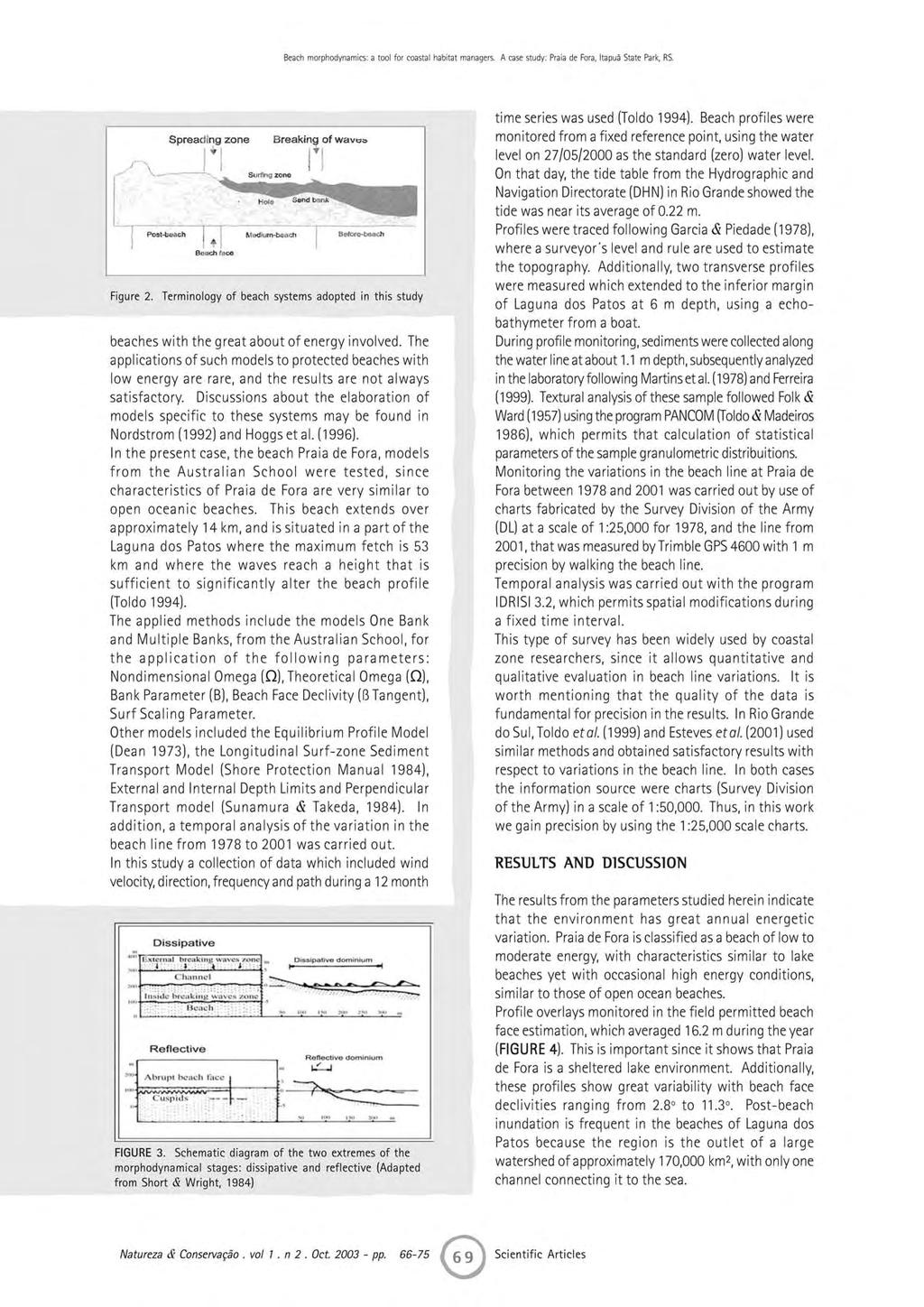
2 Beach morphodynamics: a tool for coastal habitat managers. A case study: Praia de Fora, Itapuã State Park, RS. Borzone 2000). Here, we report on an analysis of the principal morphodynamical characteristics of the beaches at Praia de Fora in the Itapuã State Park, Rio Grande do Sul, southern Brazil. Specific objectives were to increase knowledge of this environment, to contribute to the understanding of morphodynamical parameters and to provide recommendations for the management of this protected area. Itapuã State Park The State Environmental Protection Foundation (Fundação Estadual de Proteção Ambiental, FEPAM) included the Itapuã State Park in the Midwestern Littoral Region, as part of the Coastal Zone of Rio Grande do Sul. The park is situated in the Guaíba Watershed, which contains 28 protected areas and encompasses a great diversity of ecosystems. Together with Lake Guaíba are two parks: Jacui Delta State Park (at the confluence of the Jacui, Sinos, Gravatai and Cai rivers) in the north; Itapuã State Park at the edge of the Lagoa dos Patos in the south (Figure 1), comprising a mosaic of ecosystems such as open grassland, restingas, islands, beaches and hills that shelter a variety of fauna native to Rio Grande do Sul. Some of these species are in danger of exctinction, such as the Otter, Yellow-throated Caiman and the Red Howler Monkey. Located in the Viamão municipality (50 50 to W and to S) Itapuã State Park was created in 1973 by the state and included 1,535 ha. The park was enlarged in 1976, 1991 and finally in 1996, and now totals 5,560 ha. These lands were originally owned by the Portuguese Priest, Father José dos Reis, and part of a ranch that was established in 1733 and was fragmented by successive sales up until the year 1973, the year the park was created. Around 1970 tourism in the area began to grow, along with abuse. The local press began to publish stories of granite and sand mining, depredation of the local flora and fauna, and clandestine division and sale of lots in Praia de Fora (Fujimoto, 1994). In March 1991 the park was closed to visitation because of a general degradation of the ecosystem due to intensive use, tourism, burning and cattle grazing. At that time the only activities permitted in the park were maintenance and scientific studies. In April 2002 the park was finally re-opened with restrictions placed on the number of visitors and the areas that were accessible to visitation. Praia de Fora Beach Itapuã State Park includes eight beaches, seven of which are oriented towards Lake Guaíba, and the last and largest is Praia de Fora, oriented towards Lagoa dos Patos (FIGURE 1). Praia de Fora is a long sandy beach that extends approximately 14 km to the extreme southeast to the Pontal das Desertas. The conservation importance of this beach contrasts strongly with the depredations it has suffered over the years. Berte et al (1991) state that transformations due to the occupation of the Park interfered strongly with the landscape that is characterized by different environments. Those authors state that the principal impacts on the Praia de Fora were sand dune release caused by plant destruction and the removal or leveling of the protective frontal dunes, the disorderly human occupation due to illegal subdividing of the area for real estate and associated garbage production and groundwater pollution. The genesis of this beach is associated with the growth of Pontal das Desertas, which is a submersed source of sand. According to Calliari et al. (1985) the most important factors for the evolution of this beach are the prevailing winds, tide and the original shape of the beach, such that beach morphology and the absence of tidal extremes favors beach evolution in Lagoa dos Patos. According to Dillenburg & Toldo (1990) the action of tides can be considered insignificant at this beach, since scouring is dominated by the circulation of the lake canal. Other factors that reduce the influence of tidal forces are: (a) the length of the estuarine system (65km), (b) the depth of the channel of the Rio Grande (< 15m) and (c) the minimal cross section of the channel (9,000 m 2 ) which is small compared to the area of the Laguna dos Patos. MATERIAL AND METHODS Because a large part of the world s population lives near large bodies of water, the degradation of these environments has been rapid. Thus, our understandings of the phenomena that shape these areas are fundamental for the development of an efficient management strategy, especially in coastal zones. Sandy beaches are transitional systems, very dynamic and sensitive to perturbation, which are constantly adjusting to the varying local energy levels and are constantly reworked by eolian, biological and hydrological processes to which they are exposed. Beaches may be formed by sediments with varying compositions and granulometries, which, in combination with wave action will determine the beach profile (Hoefel, 1998). Nomenclature associated with beaches has not been standardized in the scientific literature. Tessler and Mahiques (2000) studied the problem of terminology and concluded that the problems come from the inconsistent classifications systems in English and that were then incorporated in etymological problems due to the adaptation to Portuguese. Here, terminology will follow that found in Angulo (1994), Klein (1996) and Ferreira (1999), as described in FIGURE 2. While the great mobility of beach environments may be considered a restrictive factor in the elaboration of models of beach dynamics, the application of empirical parameters has been shown to be an important tool for the interpretation of the spectrum of variables involved. The study of beach morphodynamics and three- Natureza & Conservação. vol 1. n 2. Oct pp

3 João Luiz Nicolodi - Elírio E. Toldo Jr. dimensional variations had its beginning in Japan in the 1960s and the United States in the 1970s with the first sequential models of beach variation. The difficulty in obtaining oceanographic data due to technological limitations at that time resulted in a slow development of the study of beach environments compared to continental environments. In the beginning of the 1980s the so-called Australian School of Costal Geomorphology had its inception. Studies such as Wright (1981), Short & Hesp (1982), Wright & Short (1984) introduced the morphodynamical classification for beaches and used the concept of mophodynamical stage to refer to the range of hydrodynamic, depositional, and sediment redistribution processes that are associated with beaches. Six morphodynamical stages were described; FIGURE 3 illustrates the dissipative and reflective extremes. It is worth emphasizing that the great majority of the proposed models were developed for open ocean Figure 1. Location of Praia de Fora Beach and the Itapuã State Park together with the Lagoa dos Patos Lagoon Natureza & Conservação. vol 1. n 2. Oct pp
4
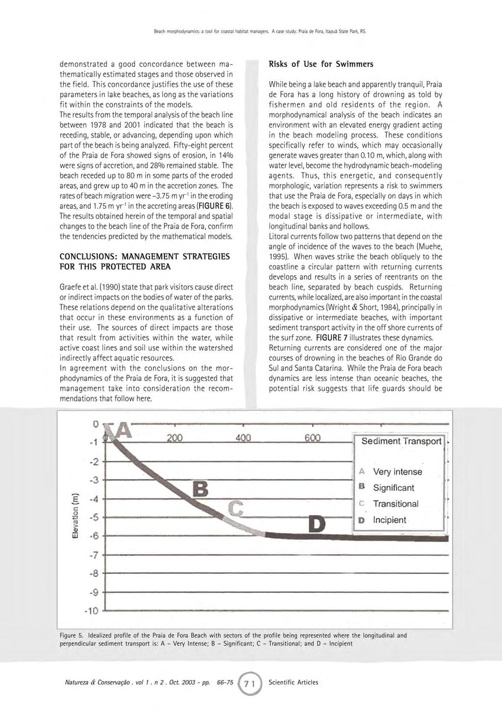
5 João Luiz Nicolodi - Elírio E. Toldo Jr. Using the One Bank model in the analysis of profile morphology showed an alternation of beach morphodynamical stages. The Omega parameter (S) applied to wave prediction data for 1988 (Toldo 1994) indicated intermediate stages with a frequency of 59%, and a dissipative stage with a frequency of 41%. Using this parameter here, the model indicated the occurrence of all morphodynamical stages proposed by the Australian Model, including reflective stages, which confers the proposition that the Praia de Fora has a great profile mobility. There were discrepancies between the stages predicted by S and the observed patterns in the field. These discrepancies were caused by a difference between hydrodynamic conditions acting at the moment of data collection and the stages suggested by the model, which was a consequence of the energetic variation and the morphological alteration of the beach being out of temporal phase with each other. In the Laguna dos Patos these time intervals may be larger, since in this region it is common for several days to pass without conditions necessary to generate waves. Equilibrium profile concepts were applied to the situation at Praia de Fora by use of two transverse profiles that were measured on the beach line at 6 m depth. These data indicate that Praia de Fora presented, on the day the profiles were measured, a perpendicular sediment transport in an onshore direction, with the beach face being depositional. Statistical parameters of the external and internal limits of the beach defined, with reasonable precision, active longitudinal and transversal sandy transport zones. That is, they defined a zone at the least depth of which significant profile alterations do not occur during the year. These depth values define the limits of the zones in which sediment movement is: (a) very intense, at depths between m; (b) significant, at depths between m; (c) transitional, between 5 6 m; and incipient, at depths > 6 m (FIGURE 5). These are in agreement with known dynamics of the Laguna dos Patos, where the submerged relief is divided into two large morphological regions: the lake margins, between the beach line and 5 m depth, and characterized by silty and sandy sediments. The application of the longitudinal sediment transport method, proposed by the Shore Protection Manual, to the predicted tides for the Praia de Fora in 1988, indicated a transport bidirectionality, with approximately 55% going SE and 45% to the NW. These data were compared to those of Toldo (1994), in which the parallel energy flux was calculated, and both were in agreement, as anticipated, with only a 4% difference in the two methods. These results are in agreement with the geomorphological evidence present along the line of the Praia de Fora, such as the existence of erosion or accretion zones at the extremities of this beach system. Results obtained from application of the method to determine the direction of perpendicular sediment transport indicated that approximately 76% of the time, the sediments were transported in an offshore direction, characterized by beach erosion. In 15%, the sediments are transported in an onshore direction, causing beach accretion. In only 1% of the time, perpendicular transport was null. All of the parameters used in the mathematical models were elaborated with empirically based studies of oceanic beaches. The application of these parameters to the case study of the Praia de Fora Figure 4. Overlap of the profiles that were monitored in the field. Zero level indicates the water level on 27/05/2000, when the tide table from the Hydrographic and Navigation Directorate (DHN) in Rio Grande showed a water level approximately that of the average, at 0.22m Natureza & Conservação. vol 1. n 2. Oct pp
6
7
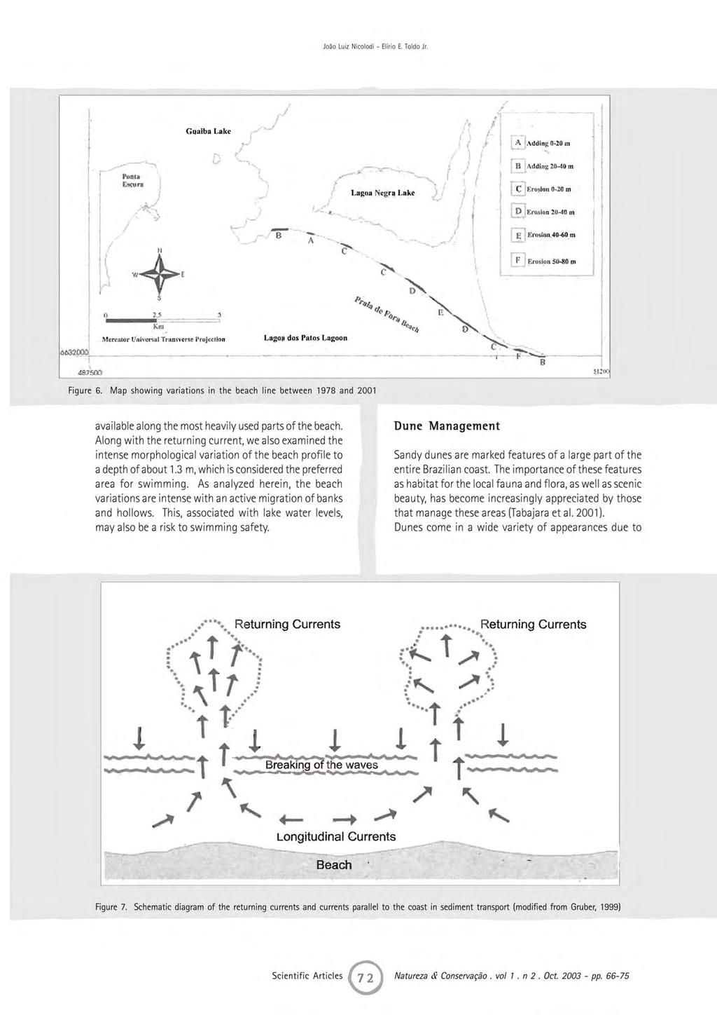
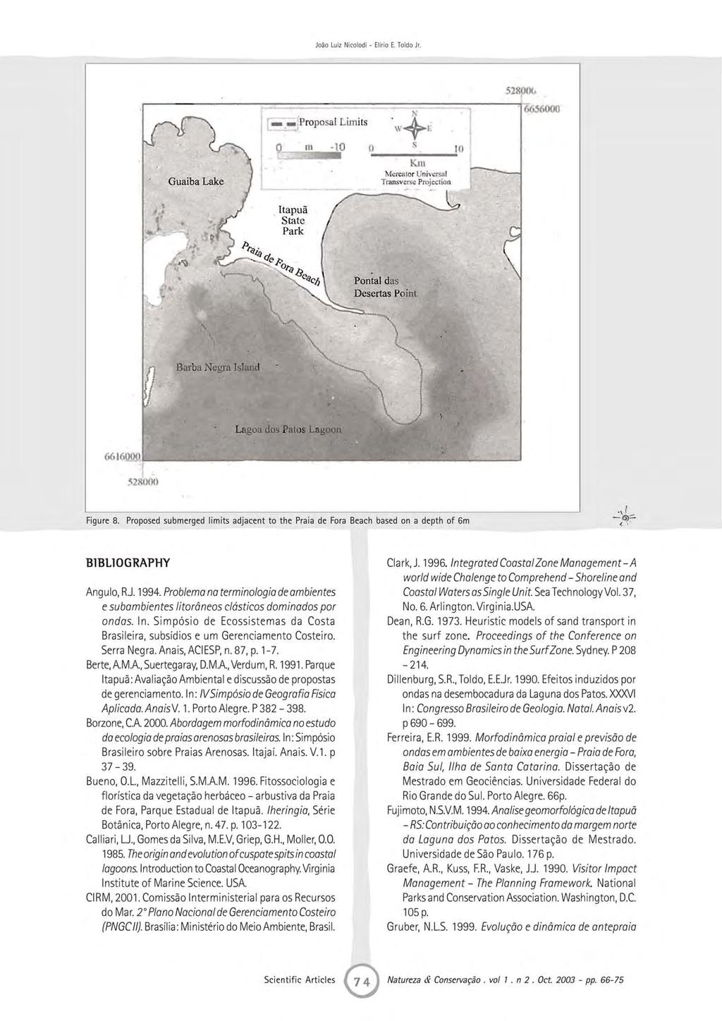
8 Beach morphodynamics: a tool for coastal habitat managers. A case study: Praia de Fora, Itapuã State Park, RS. their dynamic character, resulting from the interactions of various factors, such as sediments, vegetation, wind and anthropogenic activities. The latter of which is responsible for large changes in the geomorphology and ecology of these systems. In Itapuã Park, dunes provide an environment of great beauty and complexity, with the best represented portion found at Praia de Fora, especially in the northwest part, at Pontal de Itapuã. Before its closing for restoration in 1991, the disorganized use of this area caused several impacts, such as the activation of fixed dunes, in consequence of the deforestation and of sand mining and leveling of the frontal dunes. It is considered that, along with scenic and environmental importance, the dune field of Praia de Fora, but especially the frontal part, functions as a natural protection against raised water levels of the lagoon. It was observed that the water elevation is fundamental in the dynamics of this environment, making the features of frontal dunes of fundamental importance for beach preservation. We suggest that studies continue of the dune field of the Praia de Fora along with analysis of their genesis, dynamics and vulnerability of dunes. We also suggest that the Park develop an environmental education action based on the importance of dune preservation for the Praia de Fora. Sand Mining Based on the morphological compartmentalization of the lake margin and relationships between morphology, sedimentology and hydrodynamic regime discussed in this study, we consider that the submerged area adjacent to the Praia de Fora, between the beach line and a depth of 6 m, comprises a zone that should not be used for sand exploitation. Due to the absence of a source of sand or external sediment source, this area comprises a sediment reservoir for the entire beach system, making sand mining here unviable. Anchored to this factor, FIGURE 5 demonstrates that up to the depth of 5 m longitudinal and transversal sediment transport is considerable at Praia de Fora, such that any exploitation here may cause a large disequilibrium of this system, reflected directly in the behavior of the beach line, intensifying erosive or depositional processes, with their associated environmental problems (including park visitation), such as a retro gradation of the entire beach system. A limit of 6 m in depth as the limit for sediment mining includes all of the lake margin, that reaches to 5 m in depth and including a security zone of 1 m, as a function of changes in lake water levels. given to underwater boundary definition. In the same way that the above ground boundaries impedes real estate exploitation within the ecosystem, we believe that a submerged area adjacent to the park ought to be delimited as a way to help in the management of this protected area. The creation of submerged boundaries for the Itapuã State Park will bring practical benefits to the parks administration. As an example, we cite Article 212 of chapter XI of the State Environmental Code that determines that mining activities cannot be developed in geographical accidents that have environmental, scenic, historical, cultural, esthetic or tourist values as defined by competent agencies. Conclusions about the morphodynamics of the region of the Praia de Fora described in this study permit the suggestion of the delimitation of a protection zone at a depth of 6 m, which will protect the environments where dynamics are most intense and consequently susceptible to anthropogenic, damaging, interference (FIGURE 8). We emphasize that the proposed delimitation cannot be extended to the other beaches of the park, because they pertain to another body of water, Lake Guaíba, with its distinct dynamics. Studies with similar objectives are necessary to aid in the determination of submerged boundaries for all of Itapuã State Park, including areas adjacent to the lake s beaches. In addition to the benefits for conservation and management of the Park, this will generate technical subsidies for the implementation of ecological corridors connecting to Lake Guaíba. Protection of Barba Negra Island We also suggest the protection of Barba Negra Island (FIGURE 8), formed exclusively by sandy sediments deposited by the lake waters and winds as a result of the dynamics of the outlet of Lake Guaíba into Laguna dos Patos. This is the only island near the park that has these characteristics, such that any alterations of the dynamics of this system may have consequences for the island s structure, causing considerable damage to the system. The island has a little known herbaceous - shrubby vegetation, whose preservation is fundamental in order to better understand this ecosystem (Bueno 1996). Submersed Boundaries of the Itapuã State Park While Itapuã State Park has defined above-ground boundaries for several years, no consideration has been Natureza & Conservação. vol 1. n 2. Oct pp
9
10 Beach morphodynamics: a tool for coastal habitat managers. A case study: Praia de Fora, Itapuã State Park, RS. (Shoreface): O conceito de Perfil de Equilíbrio numa analise critica. Prova de qualificação para obtenção de titulo de Doutor em Geociências. UFRGS. 140 p. Hegge, B., Eliot, I., Hsu, J Sheltered Sandy Beaches of Southwestern Australia. Journal of Coastal Research. V. 12 (3), p Hoeffel, F Morfodinâmica de Praias. Ed. UNIVALI. Itajaí, Santa Catarina, Brasil. 140p. Klein, A.H.F Concheiros do Albardão: Variações espaço-temporais dos sedimentos e da morfologia praial. Porto Alegre, 120 p. Dissertação de Mestrado em Geociências, Universidade Federal do Rio Grande do Sul. Mclachlan, A. & Erasmus, T Sandy Beaches as Ecosystems. 1 st. Ed. The Hague, Dr. Junk Publishers. 756 p. Muehe, D Geomorfologia Costeira. In: Geomorfologia, uma Atualização de Bases e Conceitos. Ed. Bertrand Brasil. Rio de Janeiro, Brasil. 472 p. Nicolodi, J.L A Morfodinâmica Praial como Subsidio ao Gerenciamento Costeiro. O Caso da Praia de Fora Parque Estadual de Itapuã, RS. Dissertação de Mestrado. Instituto de Geociências Universidade Federal do Rio Grande do Sul. Porto Alegre. 138p. Nordstrom, K.F Estuarine Beaches. Institute os Marine and Coastal Studies, Rutger University, New Jersey, USA: Elsevier Publishing. 225 p. Rodríguez, J.J. & Windevoxhel, N.J Análisis Regional de la Situación de la Zona Marina Costera Centroamericana. Banco Inter-Americano de Desenvolvimento BID. Washington, D.C. No. ENV 121. Shore Protection Manual U.S. Army Engineer Experiment Station. Vicksburg. 4 ed. MS, 2v. Short, A.D. & Hesp, P. A Wave, beach and dune interaction in southeastern Australia. Marine Geology. V.48. p Sunamura, T., Takeda, I Landward migration of inners-bars. Marine Geology. V.60. p Tabajara, L.L., Martins, L.R.S., Nicolodi, J.L Programa de Manejo de Dunas das Praias de Osório RS. Pesquisas em Geociências. Instituto de Geociências UFRGS. Porto Alegre. V.28(2), p Tessler, M.G. & Mahiques, M.M Por uma terminologia brasileira para o ambiente praial. In: Simpósio Brasileiro sobre Praias Arenosas. Itajaí. Anais. V.1. p Toldo, E.E.Jr Sedimentação, Predição do padrão de ondas e dinâmica sedimentar da antepraia e zona de surfe do sistema lagunas da Lagoa dos Patos, RS. Tese de doutorado. Instituto de Geociências. Universidade Federal do Rio Grande do Sul. Porto Alegre. 178 p. Wright, L.D Beach cut in relation to surf zone morphodynamics. In: Proceedings of the 17 th International Coastal Engineering Conference, ASCE. Sydney, Australia. P Wright, L.D., Short, A.D Morphodynamics variability of surf zones and beaches: a synthesis. Marine Geology. V.56. p Natureza & Conservação. vol 1. n 2. Oct pp
Morphology, Vegetation and Sand Fence Influence on Sand Mobility of the Foredune System of Atlântida Sul Beach, Rio Grande do Sul, Brazil
 Journal of Coastal Research SI 39 616-621 ICS 2004 (Proceedings) Brazil ISSN 0749-0208 Morphology, Vegetation and Sand Fence Influence on Sand Mobility of the Foredune System of Atlântida Sul Beach, Rio
Wave dynamics and resuspension in Lake Guaíba (Brazil) with implications on points of water abstraction for human supply
 with implications on points of water abstraction for human supply") Journal of Coastal Research SI 64 1550-1554 ICS2011 (Proceedings) Poland ISSN 0749-0208 Wave dynamics and resuspension in Lake Guaíba (Brazil) with implications on points of water abstraction for human
Journal of Coastal Research SI 64 1550-1554 ICS2011 (Proceedings) Poland ISSN 0749-0208 Wave dynamics and resuspension in Lake Guaíba (Brazil) with implications on points of water abstraction for human
MEMORANDUM FOR SWG
 MEMORANDUM FOR SWG-2007-1623 Subject: Jurisdictional Determination (JD) for SWG-2007-1623 on Interdunal Wetlands Adjacent to Traditional Navigable Waters (TNWs) Summary The U.S. Environmental Protection
Annual transport rates at two locations on the fore-slope.
 Sediment Transport by Currents Fore-slope Sediment transport rates and sediment concentrations were computed from the hydrodynamic model runs as well as from direct measurements of current velocities at
Coastal Barrier Island Network (CBIN): Management strategies for the future
: Management strategies for the future") Coastal Barrier Island Network (CBIN): Management strategies for the future Heather Joesting*, Amy Williams**, Rusty Feagin**, and William K. Smith* *Department of Biology, Wake Forest University, Winston
Coastal Barrier Island Network (CBIN): Management strategies for the future Heather Joesting*, Amy Williams**, Rusty Feagin**, and William K. Smith* *Department of Biology, Wake Forest University, Winston
Physical Geography: Patterns, Processes, and Interactions, Grade 11, University/College Expectations
 Geographic Foundations: Space and Systems SSV.01 explain major theories of the origin and internal structure of the earth; Page 1 SSV.02 demonstrate an understanding of the principal features of the earth
xxv PART I THE DIVIDED OCEANS: INTERNATIONAL LAW GOVERNING JURISDICTIONAL ZONES 1
 Contents Preface page xv List of Figures xvii List of Tables xviii List of Abbreviations xix Table of Cases xxi Table of Treaties and Instruments xxv PART I THE DIVIDED OCEANS: INTERNATIONAL LAW GOVERNING
Soil erosion susceptibility and coastal evolution: examples in southern New Caledonia
 Pacific Island Countries GIS /RS User Conference Soil erosion susceptibility and coastal evolution: examples in southern New Caledonia Pascal DUMAS et Olivier COHEN University of New-Caledonia (EA 4242/
Connecticut Coastal Management Program
 Connecticut Coastal Management Program Fact Sheet for SHORELINE FLOOD AND EROSION CONTROL STRUCTURES What are Shoreline Flood and Erosion Control Structures? The Connecticut General Statutes (CGS) define
SHORELINE AND BEACH PROCESSES: PART 2. Implications for Coastal Engineering
 SHORELINE AND BEACH PROCESSES: PART 2 Implications for Coastal Engineering Objectives of the lecture: Part 2 Show examples of coastal engineering Discuss the practical difficulties of ocean engineering
Coastal Environment. Introduction. 4.1 Coastal Environment. Extent of Coastal Environment
 4 The primary objective (set out in Chapter 2) to be implemented by this Chapter is Objective 2.4 ; the following objectives are also relevant due to the objectives integrated nature: 2.1 Tāngata whenua
SEGMENTED BREAKWATERS AND THEIR USE IN COASTAL LOUISIANA
 SEGMENTED BREAKWATERS AND THEIR USE IN COASTAL LOUISIANA Prepared by: Louisiana Coastal Protection and Restoration Authority Engineering Division March 2016 The geology of Louisiana s coastal zone is intimately
9 th INTECOL Orlando, Florida June 7, 2012
 Restoration of the Everglades Saline Wetlands and Florida Bay: Responses Driven from Land and Sea David Rudnick 1, Colin Saunders 2, Carlos Coronado 2, Fred Sklar 2 Erik Stabenau 1, Vic Engel 1, Rene Price
Regional-scale understanding of the geologic character and sand resources of the Atlantic inner continental shelf, Maine to Virginia
 Regional-scale understanding of the geologic character and sand resources of the Atlantic inner continental shelf, Maine to Virginia Workshop on Dredging, Beach Nourishment and Bird Conservation Atlantic
NOAA Nautical Charts and Coastal and Marine Spatial Planning. Meredith Westington Chief Geographer NOAA/NOS/Office of Coast Survey
 NOAA Nautical Charts and Coastal and Marine Spatial Planning Meredith Westington Chief Geographer NOAA/NOS/Office of Coast Survey Ocean Policy Task Force What is CMSP? A comprehensive, adaptive, integrated,
Coastal Processes and Shoreline Erosion on the Oregon Coast, Cascade Head to Cape Kiwanda
 State of Oregon Department of Geology and Mineral Industries Vicki S. McConnell, State Geologist Open File Report OFR O-04-11 Coastal Processes and Shoreline Erosion on the Oregon Coast, Cascade Head to
Caspian Rapid Sea Level Changing Impact on Estuaries Morphodynamic Deformation
 2013, TextRoad Publication ISSN 2090-4304 Journal of Basic and Applied Scientific Research www.textroad.com Caspian Rapid Sea Level Changing Impact on Estuaries Morphodynamic Deformation Naser Ebadati
Weathering of Rocks. Weathering - Breakdown of rocks into pieces (sediment) 2 main types of weathering to rocks
 2 main types of weathering to rocks") Weathering of Rocks Weathering - Breakdown of rocks into pieces (sediment) 2 main types of weathering to rocks Mechanical weathering requires physical forces to break rocks into smaller pieces. Chemical
Weathering of Rocks Weathering - Breakdown of rocks into pieces (sediment) 2 main types of weathering to rocks Mechanical weathering requires physical forces to break rocks into smaller pieces. Chemical
OVERWASHED SEDIMENT INTO THE GAMO LAGOON IN NANAKITA RIVER MOUTH AND EFFECTIVENESS OF THE OVERWASH PREVENTION CONSTRUCTION
 東北地域災害科学研究第 6 巻 (010) 191 OVERWASHED SEDIMENT INTO THE GAMO LAGOON IN NANAKITA RIVER MOUTH AND EFFECTIVENESS OF THE OVERWASH PREVENTION CONSTRUCTION ABSTRACT Xuan Tinh Nguyen 1, Ryutaro Hirao, Hitoshi
Ecosystems at Risk Case Study 1 Coastal Sand Dunes- Stockton Bight Introduction
 Ecosystems at Risk Case Study 1 Coastal Sand Dunes- Stockton Bight Introduction 1. What are Coastal Sand Dune ecosystems? 2. What are the natural functions of Coastal Sand Dunes? 3. Why are the Stockton
Dunes Growth Estimation for Coastal Protection
 Dunes Growth Estimation for Coastal Protection Muhammad Zikra Department of Ocean Engineering, Faculty of Marine Technology, ITS, Kampus ITS Keputih Sukolilo, Surabaya 60111 Abstract: This paper describes
Stream Restoration and Environmental River Mechanics. Objectives. Pierre Y. Julien. 1. Peligre Dam in Haiti (deforestation)
") Stream Restoration and Environmental River Mechanics Pierre Y. Julien Malaysia 2004 Objectives Brief overview of environmental river mechanics and stream restoration: 1. Typical problems in environmental
Stream Restoration and Environmental River Mechanics Pierre Y. Julien Malaysia 2004 Objectives Brief overview of environmental river mechanics and stream restoration: 1. Typical problems in environmental
Elwha River response to dam removals through four years and a big flood:
 Elwha River response to dam removals through four years and a big flood: Lessons learned, channel response, and sediment effects from the world s largest engineered dam removal Andy Ritchie NPS Elwha Restoration
Why Geomorphology for Fish Passage
 Channel Morphology - Stream Crossing Interactions An Overview Michael Love Michael Love & Associates mlove@h2odesigns.com (707) 476-8938 Why Geomorphology for Fish Passage 1. Understand the Scale of the
Overview of Methods. Terrestrial areas that are most important for conservation Conservation
 Overview of Methods The goal of the Western Lake Erie Coastal Conservation Vision project (WLECCV) is to define where we should be working locally to optimally achieve regional conservation impact. The
DIVISION OF COASTAL MANAGEMENT TO STUDY CURRENT LONG-TERM EROSION RATES ADJACENT TO TERMINAL GROINS
 DIVISION OF COASTAL MANAGEMENT TO STUDY CURRENT LONG-TERM EROSION RATES ADJACENT TO TERMINAL GROINS North Carolina Department of Environmental Quality Division of Coastal Management February 22, 2018 N.
Lab 12 Coastal Geology
 Lab 12 Coastal Geology I. Fluvial Systems Hydrologic Cycle Runoff that flows into rivers = precipitation (rain and snowmelt) [infiltration (loss to groundwater) + evaporation (loss to atmosphere) + transpiration
GLY Coastal Geomorphology Notes
 GLY 4734 - Coastal Geomorphology Notes Dr. Peter N. Adams Spring 2011 2 Coastal Classification In this lecture, we discuss some successful classification schemes of the coastal landscape, and pay particular
Protecting the Storm Damage Prevention and Flood Control Interests of Coastal Resource Areas
 Protecting the Storm Damage Prevention and Flood Control Interests of Coastal Resource Areas Presented by: Massachusetts Department of Environmental Protection & Massachusetts Office of Coastal Zone Management
Resolution XIII.23. Wetlands in the Arctic and sub-arctic
 13th Meeting of the Conference of the Contracting Parties to the Ramsar Convention on Wetlands Wetlands for a Sustainable Urban Future Dubai, United Arab Emirates, 21-29 October 2018 Resolution XIII.23
BEFORE THE ENVIRONMENTAL PROTECTION AUTHORITY AT WELLINGTON
 BEFORE THE ENVIRONMENTAL PROTECTION AUTHORITY AT WELLINGTON IN THE MATTER of the Exclusive Economic Zone and Continental Shelf (Environmental Effects) Act 2012 (EEZ Act) AND IN THE MATTER BETWEEN AND AND
Aim and objectives Components of vulnerability National Coastal Vulnerability Assessment 2
 ASSESSING THE UTILITY OF GEOMORPHIC SENSITIVITY MAPPING ON THE ILLAWARRA COAST Pamela Abuodha, Christina Baker, Chris Sharples, Darren Skene and Colin Woodroffe Geoquest Research Centre, University of
Coastal Vulnerability and Risk Parameters
 European Water 11/12: 3-7, 2005. 2005 E.W. Publications Coastal Vulnerability and Risk Parameters E. Doukakis National Technical University of Athens-Dept. of Rural and Surveying Engineering, Lab. of Higher
Phillip Island Nature Parks Coastal Process Study 8 October 2014
 Phillip Island Nature Parks Coastal Process Study 8 October 2014 Project Overview Coastal Geology Basaltic and fragmented lavas, granite at Pyramid Rock and Cape Woolamai Weathered basalt (>10m thick)
MATHEMATICAL MODELING OF FLUVIAL SEDIMENT DELIVERY, NEKA RIVER, IRAN. S.E. Kermani H. Golmaee M.Z. Ahmadi
 JOURNAL OF ENVIRONMENTAL HYDROLOGY The Electronic Journal of the International Association for Environmental Hydrology On the World Wide Web at http://www.hydroweb.com VOLUME 16 2008 MATHEMATICAL MODELING
EXTERNAL LAND FORMING PROCESSES
 NAME SCHOOL INDEX NUMBER DATE EXTERNAL LAND FORMING PROCESSES WEATHERING 1 1998 Q 7 (a) (i) What is the difference between weathering and mass wasting (ii) List five processes involved in chemical weathering
3/3/2013. The hydro cycle water returns from the sea. All "toilet to tap." Introduction to Environmental Geology, 5e
 Introduction to Environmental Geology, 5e Running Water: summary in haiku form Edward A. Keller Chapter 9 Rivers and Flooding Lecture Presentation prepared by X. Mara Chen, Salisbury University The hydro
Missouri Educator Gateway Assessments
 Missouri Educator Gateway Assessments FIELD 019: EARTH SCIENCE June 2014 Content Domain Range of Competencies Approximate Percentage of Test Score I. Science and Engineering Practices 0001 0003 18% II.
Core Examples from Modern Estuarine Tidal Bars, Tillamook Bay, Oregon
 Core Examples from Modern Estuarine Tidal Bars, Tillamook Bay, Oregon Rares Bistran* University of Alberta, Edmonton, Alberta, Canada rares.bistran@ualberta.ca David Herbers, Murray Gingras, John-Paul
Current and Future Technology Applications for Coastal Zone Management. Bruce K. Carlisle, Acting Director Office of Coastal Zone Management
 Current and Future Technology Applications for Coastal Zone Management Bruce K. Carlisle, Acting Director Office of Coastal Zone Management The Massachusetts Coastal Zone Management Program Approved in
Sri Lanka has a coastline of km excluding the shoreline of bays and inlets.
 Defining and Demarcating Coastal zones in Sri Lanka Procedure, Challenges and What needs to be done? Dr. Anil Premaratne Director General Coast Conservation Coast Conservation Department Sri Lanka 1 Sri
The Ordinary High Water Mark: Concepts, Research, and Applications. Matthew K. Mersel March 20, 2013
 The Ordinary High Water Mark: Concepts, Research, and Applications Matthew K. Mersel March 20, 2013 Under Section 404 of the Clean Water Act, the OHWM defines the lateral limits of Federal jurisdiction
Upper Truckee River Restoration Lake Tahoe, California Presented by Brendan Belby Sacramento, California
 Upper Truckee River Restoration Lake Tahoe, California Presented by Brendan Belby Sacramento, California Mike Rudd (Project Manager), Charley Miller & Chad Krofta Declines in Tahoe s Water Clarity The
Chapter 32. Australia & New Zealand
 Chapter 32 Australia & New Zealand Lesson 1: Physical Geography of Australia & New Zealand Landforms Australia lies between the Pacific and Indian Oceans in the Southern Hemisphere. Although an island,
North Coastal Zone Management of the Adriatic Sea and the Measures Taken To Protect the Coast from Sea Erosion
 IOSR Journal of Environmental Science, Toxicology and Food Technology (IOSR-JESTFT) e-issn: 2319-2402,p- ISSN: 2319-2399.Volume 9, Issue 1 Ver. II (Jan. 2015), PP 23-27 www.iosrjournals.org North Coastal
Australian Coastal Councils Conference
 Australian Coastal Councils Conference 11 March 2015 Estimating Future Coastal Inundation and Erosion Hazards Dr Andrew McCowan Dr Christine Lauchlan-Arrowsmith Warwick Bishop Background Victorian Future
ΛTKINS. Applications of Regional Sediment Management Concepts in Texas Estuarine Restoration Projects. Riparian Workshop Fort Worth, October 17, 2012
 Juan C Moya, PhD., PG Coastal Planning and Restoration Applications of Regional Sediment Management Concepts in Texas Estuarine Restoration Projects Riparian Workshop Fort Worth, October 17, 2012 West
Newsletter # 2. Pilot sites in Greece. December 2018
 A HarmonizEd framework to Mitigate coastal EroSion promoting ICZM protocol implementation Newsletter # 2 December 2018 View of a beach in Ammolofi ( Paggaio Municipality ) Pilot sites in Greece 1. Name
Moreton Bay and Key Geographic Concepts Worksheet
 Moreton Bay and Key Geographic Concepts Worksheet The Australian Curriculum: Geography draws on seven key geographic concepts: place scale space environment change interconnection sustainability They are
RANGE AND ANIMAL SCIENCES AND RESOURCES MANAGEMENT - Vol. II - Catchment Management A Framework for Managing Rangelands - Hugh Milner
 CATCHMENT MANAGEMENT A FRAMEWORK FOR MANAGING RANGELANDS Hugh Milner International Water Management Consultant, Australia Keywords: Rangeland management; catchments and watersheds; catchment management
FOREST RESEARCH INSTITUTE, DEHRADUN
 PROJECT REPORT DRAINAGE AND REPLENISHMENT STUDY OF MINED AREA OF GANGA SHYAMPUR RIVER HARIDWAR Submitted to UTTARAKHAND FOREST DEVELOPMENT CORPORATION (UFDC) 73, Nehru Road, Deharadun Prepared&Submitted
Forecast of Nearshore Wave Parameters Using MIKE-21 Spectral Wave Model
 Forecast of Nearshore Wave Parameters Using MIKE-21 Spectral Wave Model Felix Jose 1 and Gregory W. Stone 2 1 Coastal Studies Institute, Louisiana State University, Baton Rouge, LA 70803 2 Coastal Studies
TROPICAL BIOLOGY AND CONSERVATION MANAGEMENT - Vol. IV - Sandy Coastal Vegetation - D.S.D. Araujo, M.C.A. Pereira
 SANDY COASTAL VEGETATION D.S.D. Araujo Department of Ecology, Rio de Janeiro Federal University, Brazil M.C.A. Herbarium, Rio de Janeiro Botanical Garden, Brazil Keywords: Vegetation types, flora, community
Regional Sediment Management
 Regional Sediment Management Linda S. Lillycrop Program Manager Coastal Engineer US Army Engineer Research and Development Center Coastal and Hydraulics Laboratory Q AVG Coastal Resilience: The Environmental,
INTEGRATED COASTAL SEDIMENT MANAGEMENT AT PHYSIOGRAPHIC UNIT SCALE, AN APPLICATION IN VERSILIA LITTORAL (TUSCANY, ITALY)
") INTEGRATED COASTAL SEDIMENT MANAGEMENT AT PHYSIOGRAPHIC UNIT SCALE, AN APPLICATION IN VERSILIA LITTORAL (TUSCANY, ITALY) Damiano Scarcella (Msc) Sergio Cappucci (PhD) Andrea Taramelli (PhD) OUTLINE Sediment
INTEGRATED COASTAL SEDIMENT MANAGEMENT AT PHYSIOGRAPHIC UNIT SCALE, AN APPLICATION IN VERSILIA LITTORAL (TUSCANY, ITALY) Damiano Scarcella (Msc) Sergio Cappucci (PhD) Andrea Taramelli (PhD) OUTLINE Sediment
Rising Sea Levels: Time for Proactive Action in Florida and the Caribbean?
 Rising Sea Levels: Time for Proactive Action in Florida and the Caribbean? Dr. Alan Fyall and Dr. Thomas Wahl National Center for Integrated Coastal Research, University of Central Florida Dr. Roberta
Term Knowledge Using and applying Grade Criteria Autumn 1 Assessment window October Natural hazards pose major risks to people and property.
 Assessment Schedule Year 9 2015/6 Term Knowledge Using and applying Grade Criteria Autumn 1 Assessment window October 2015 3.1.1.2 Tectonic Natural hazards pose major risks to people and property. Definition
Chapter 32. Australia & New Zealand
 Chapter 32 Australia & New Zealand Lesson 1: Physical Geography of Australia & New Zealand Landforms Australia lies between the Pacific and Indian Oceans in the Southern Hemisphere. Although an island,
Data Dictionary for Network of Conservation Areas Transcription Reports from the Colorado Natural Heritage Program
 Data Dictionary for Network of Conservation Areas Transcription Reports from the Colorado Natural Heritage Program This Data Dictionary defines terms used in Network of Conservation Areas (NCA) Reports
Pee Dee Explorer. Science Standards
 Science Standards About Pee Dee Explorer What does it mean when someone says they are from the "Pee Dee" of South Carolina? A place is bigger than its physical geography. A "sense of place" weaves together
The Coast: Beaches and Shoreline Processes
 1 2 3 4 5 6 7 8 9 The Coast: es and Shoreline Processes Trujillo & Thurman, Chapter 10 Oceanography 101 Chapter Objectives Recognize the various landforms characteristic of beaches and coastal regions.
Geol 117 Lecture 18 Beaches & Coastlines. I. Types of Coastlines A. Definition:
 I. Types of Coastlines A. Definition: 1. Shore = narrow zone where ocean meets land (e.g. beach) 2. Coast is a broad area where both ocean and land processes act a. Includes onshore marshes, dunes, sea
The Coast: Beaches and Shoreline Processes Trujillo & Thurman, Chapter 10
 The Coast: es and Shoreline Processes Trujillo & Thurman, Chapter 10 Oceanography 101 Chapter Objectives Recognize the various landforms characteristic of beaches and coastal regions. Identify seasonal
The Great Lakes Coalition is an organization of shoreline property owners on the Great Lakes dedicated to improving the quality of life for both it s
 The Great Lakes Coalition is an organization of shoreline property owners on the Great Lakes dedicated to improving the quality of life for both it s s membership and the public at large. Facts about Section
June 2018 Sediments and Dredging at GBR Ports
 June 2018 Sediments and Dredging at GBR Ports Reef 2050 Long Term Sustainability Plan The Great Barrier Reef is over 2000 km long and covers an area of approximately 350,000 square kilometres. It is a
Geography Exams. RAG rate The Challenge of Natural Hazards
 Geography Exams You will sit three papers, Paper 1 will last 1 hour 30 minutes and will examine your understanding of The Challenge of Natural Hazards, The Living World and Physical Landscapes in the UK.
Seasonal Variations and Controlling Factors of Aeolian Transport at Atlântida Sul Beach, Rio Grande do Sul, Brazil
 Journal of Coastal Research SI 39 611-615 ICS 2004 (Proceedings) Brazil ISSN 0749-0208 Seasonal Variations and Controlling Factors of Aeolian Transport at Atlântida Sul Beach, Rio Grande do Sul, Brazil
Shoreline and Climate Change Adaptation Alternatives for The Letter Parcel, Bolinas Lagoon
 Shoreline and Climate Change Adaptation Alternatives for The Letter Parcel, Bolinas Lagoon Scenic shoreline vista of Bolinas Lagoon and ridges, from Letter Parcel, March 2016 Peter Baye, Coastal Ecologist
Sediment and Sedimentary rock
 Sediment and Sedimentary rock Sediment: An accumulation of loose mineral grains, such as boulders, pebbles, sand, silt or mud, which are not cemented together. Mechanical and chemical weathering produces
3.3 Classification Diagrams Estuarine Zone Coastal Lagoons References Physical Properties and Experiments in
 Contents 1 Introduction to Estuary Studies... 1 1.1 Why to Study Estuaries?.... 1 1.2 Origin and Geological Age... 4 1.3 Definition and Terminology... 7 1.4 Policy and Actions to Estuary Preservation....
IMA s ROLE IN COASTAL AND OCEAN GOVERNANCE IN TRINIDAD AND TOBAGO
 IMA s ROLE IN COASTAL AND OCEAN GOVERNANCE IN TRINIDAD AND TOBAGO Presented by Rahanna Juman, Deputy Director (Ag.) About the Institute of Marine Affairs Institute of Marine Affairs (IMA) was established,
EAGLES NEST AND PIASA ISLANDS
 EAGLES NEST AND PIASA ISLANDS HABITAT REHABILITATION AND ENHANCEMENT PROJECT MADISON AND JERSEY COUNTIES, ILLINOIS ENVIRONMENTAL MANAGEMENT PROGRAM ST. LOUIS DISTRICT FACT SHEET I. LOCATION The proposed
Arizona Educator Proficiency Assessments (AEPA ) FIELD 04: GEOGRAPHY TEST OBJECTIVES
 FIELD 04: GEOGRAPHY TEST OBJECTIVES") Arizona Educator Proficiency Assessments (AEPA ) TEST OBJECTIVES Subarea Range of Objectives Approximate Test Proportions I. Geographic Concepts and Skills 1 6 25% II. World Geography 7 14 34% III. United
Arizona Educator Proficiency Assessments (AEPA ) TEST OBJECTIVES Subarea Range of Objectives Approximate Test Proportions I. Geographic Concepts and Skills 1 6 25% II. World Geography 7 14 34% III. United
Quantifying effects of oil on coastal dune vegetation. Thomas Miller and Elise Gornish Biological Science, Florida State University
 Quantifying effects of oil on coastal dune vegetation Thomas Miller and Elise Gornish Biological Science, Florida State University Natural History of Barrier Islands in the Northern Gulf Make up ~70% of
The Positional and Thematic Accuracy for Analysis of Multi-Temporal Satellite Images on Mangrove Areas
 The Positional and Thematic Accuracy for Analysis of Multi-Temporal Satellite Images on Mangrove Areas Paulo Rodrigo Zanin¹, Carlos Antonio O. Vieira² ¹Universidade Federal de Santa Catarina, Campus Universitário
3.0 ROBERTS BANK TIDAL FLAT MORPHOLOGY
 Vancouver Port Authority Northwest Hydraulic Consultants Ltd. /Triton Consultants Ltd. Roberts Bank Container Expansion File: 33863 Coastal Geomorphology Study - 19 - November 2004 3.0 ROBERTS BANK TIDAL
National Perspectives - Portugal. Margarida Almodovar
 National Perspectives - Portugal Margarida Almodovar margarida.almodovar@mam.gov.pt from base line to the external limit of the continental shelf behind 200 miles and according to UNCLOS definitions Economic
3.1 GEOLOGY AND SOILS Introduction Definition of Resource
 3.1 GEOLOGY AND SOILS 3.1.1 Introduction 3.1.1.1 Definition of Resource The geologic resources of an area consist of all soil and bedrock materials. This includes sediments and rock outcroppings in the
PHOTOGRAMMETRY AND GIS TECHNOL 1 OGIES FOR MONITORING COASTAL EROSION ALONG DAR ES SALAAM COASTLINE. By: Z.Y Masele, S.D Mayunga1.
 PHOTOGRAMMETRY AND GIS TECHNOL 1 OGIES FOR MONITORING COASTAL EROSION ALONG DAR ES SALAAM COASTLINE. By: Z.Y Masele, S.D Mayunga1 Abstract Dar Es salaam coastline is seriously suffering from coastal soil
IM Syllabus (2020): Geography IM SYLLABUS (2020) GEOGRAPHY IM 13 SYLLABUS
: Geography IM SYLLABUS (2020) GEOGRAPHY IM 13 SYLLABUS") IM SYLLABUS (2020) GEOGRAPHY IM 13 SYLLABUS 1 Geography IM 13 Syllabus (Available in September) Written (3 hrs) Introduction This syllabus is based on a number of core areas, each of which is expanded
IM SYLLABUS (2020) GEOGRAPHY IM 13 SYLLABUS 1 Geography IM 13 Syllabus (Available in September) Written (3 hrs) Introduction This syllabus is based on a number of core areas, each of which is expanded
Winfried Siefert ; Volker Barthel**' and
 CHAPTER 176 THE GERMAN "MORAN" PROJECT by Winfried Siefert ; Volker Barthel**' and Abstract The project "MORAN" (Morphological Analyses of the North- Sea-Coast) is an extensive program in order to try
Margarita Stancheva Hristo Stanchev & Robert Young 2. MEDCOAST JUBILEE WORKSHOP May 2015, Iberotel Sarigerme Park, Dalaman, Turkey
 Margarita Stancheva Hristo Stanchev & Robert Young 2 INTRODUCTION: Bulgarian Black Sea coast INTRODUCTION: Increasing pressure on Bulgarian coastal zone In 2011, of the 7 364 570 people that lived in Bulgaria,
Country Fiche Latvia Updated October 2016
 Country Fiche Latvia Updated October 2016 1. General information Marine area under Latvian jurisdiction includes inland sea waters, Territorial sea (12 nautical miles from the baseline) and exclusive economic
The River Restoration Centre therrc.co.uk. Understanding Fluvial Processes: supporting River Restoration. Dr Jenny Mant
 The River Restoration Centre therrc.co.uk Understanding Fluvial Processes: supporting River Restoration Dr Jenny Mant Jenny@therrc.co.uk Understanding your catchment Hydrology Energy associated with the
NOAA s OCM: Services, tools and collaboration opportunities & Puerto Rico s NE Marine Corridor as a case study
 NOAA s OCM: Services, tools and collaboration opportunities & Puerto Rico s NE Marine Corridor as a case study Dr. Antares Ramos Álvarez NOAA s Office of Coastal Management September 15 th, 2016 Conservation
Country Fiche Lithuania
 Country Fiche Lithuania Updated June 2018 1. General information The Lithuanian maritime space is delimited by the Decree of the Government of the Republic of Lithuania of 6 December, 2004, No. 1597 and
Evolution of the Po Delta, Italy
 Evolution of the Po Delta, Italy Albert Kettner & James Syvitski, Charles Vörösmarty Dynamics and Vulnerability of River Delta Systems workshop September, 2007 Outline 21,000 years ago Effects of the ever
Zoogeographic Regions. Reflective of the general distribution of energy and richness of food chemistry
 Terrestrial Flora & Fauna Part II In short, the animal and vegetable lines, diverging widely above, join below in a loop. 1 Asa Gray Zoogeographic Regions Reflective of the general distribution of energy
24.0 Mineral Extraction
 Chapter 24 - Mineral Extraction 24.0 Mineral Extraction 24.1 Introduction Apart from gravel, sand, rock, limestone and salt extraction in relatively small quantities mineral extraction is not a strong
SIF_7.1_v2. Indicator. Measurement. What should the measurement tell us?
 Indicator 7 Area of natural and semi-natural habitat Measurement 7.1 Area of natural and semi-natural habitat What should the measurement tell us? Natural habitats are considered the land and water areas
Geography for Life. Course Overview
 Geography for Life Description In Geography for Life students will explore the world around them. Using the six essential elements established by the National Geographic Society students will be able to
Naturally. Westport... Wet and Wild...
 Westport... Wet and Wild... Naturally A revitalization concept for the City of Westport and Port of Grays Harbor presented by FOGH (Friends of Grays Harbor), Wildlife Forever of Grays Harbor and other
Tips for Success on a Test
 Number of Incorrect: Final Grade: Parent Signature: Top Tips for Success on a Test 1. Read the following statements at least two times. 2. Circle the key words in each question/ or statement. (*Remember
ENGINEERING WITH NATURE: NEARSHORE BERM PLACEMENTS AT FORT MYERS BEACH AND PERDIDO KEY, FLORIDA, USA
 1 ENGINEERING WITH NATURE: NEARSHORE BERM PLACEMENTS AT FORT MYERS BEACH AND PERDIDO KEY, FLORIDA, USA KATHERINE E. BRUTSCHÉ 1, PING WANG 2, JULIE D. ROSATI 1, CHERYL E. POLLOCK 1 1. U.S. Army Engineer
Mangrove Erosion in the Mekong delta
 Mangrove Erosion in the Mekong delta 1. Introduction a. Mangrove coast - a balance between different forcing factors Mangroves are coastal environments frequently observed in the tropical muddy coasts.
CAPE Unit 1 Module 2 & 3. Topic Specific Objectives Content Explain the main concepts, flows and processes associated with coastal environments
 # Week(s) Wks 1-3 CAPE Unit 1 Module 2 & 3 Topic Specific Objectives Content Explain the main concepts, flows and processes associated with coastal environments Wave formation, structure, types Textbook
Changes in Texas Ecoregions Copy the questions and answers
 Changes in Texas Ecoregions Copy the questions and answers 1. What are some kinds of damage that hurricanes cause? Roads and bridges might be washed away. Trees and power lines can be knocked down. Area
HELSINKI COMMISSION Baltic Marine Environment Protection Commission
 HELSINKI COMMISSION Baltic Marine Environment Protection Commission HELCOM RECOMMENDATION 24/10 Adopted 25 June 2003, having regard to Article 20, Paragraph 1 b) of the 1992 Helsinki Convention IMPLEMENTATION
Ecoregions Glossary. 7.8B: Changes To Texas Land Earth and Space
 Ecoregions Glossary Ecoregions The term ecoregions was developed by combining the terms ecology and region. Ecology is the study of the interrelationship of organisms and their environments. The term,
Planning for the Future of Humboldt Bay: Sea Level Rise, Sediment Management, Sand Spits and Salt Marshes. Joel Gerwein
 Planning for the Future of Humboldt Bay: Sea Level Rise, Sediment Management, Sand Spits and Salt Marshes Joel Gerwein Introduction to Humboldt Bay Setting Economy, community, and environment Sediment