IMPLYING ON TECTONICS OF BOROD BASIN (NW PART OF APUSENI MOUNTAINS, ROMANIA) C. BALICA and M.-V. POPA
|
|
|
- Hortense Newman
- 5 years ago
- Views:
Transcription
1 IMPLYING ON TECTONICS OF BOROD BASIN (NW PART OF APUSENI MOUNTAINS, ROMANIA) C. BALICA and M.-V. POPA Babes-Bolyai University, Department of Geology, M. Kogalniceanu 1, 3400 Cluj Napoca, Romania ABSTRACT: Exploration with geological drill holes of Sarmatian coals from Borod Basin, situated in north-western part of Apuseni Mountains, gave us the necessary information in order to build up some morpho structural models for the pre-neogene basement as well as for the previously identified lithostratigraphic units. Thus it is confirmed the previous hypotheses regarding the opening of the basins from western part of Apuseni Mountains, along of normal listric faults. KEYWORDS: Borod Basin, tectonics, digital elevation model. Introduction The Neogene Borod Basin is located in NW part of the Apuseni Mountains, bounded by the Plopis Mountains in the North and Padurea Craiului in the South. The basin represent one of the eastern prolongation of the Pannonian Basin, being oriented WNW-ESE (Fig. 1) TISZA-DACIA block it is found in the basement of the Pannonian Basin and the Apuseni Mountains as well. Along of Central-Hungarian translithospheric faults alignment, the ALCAPA block positioned northwesterly, contacting the TISZA-DACIA block situated southeasterly. During the lower Miocene the ALCAPA block suffered a northeastward displacement along the mentioned alignment, combined with a counterclockwise rotation. In the mean time the TISZA-DACIA block has rotated clockwise and translated towards east (e.g. Csontos, 1995). In a different opinion (Kováč & Márton, 1998), during the early Miocene time, the ALCAPA block suffered a counterclockwise rotation combined with lateral towards right displacement along the northern margin of the TISZA-DACIA micro-plate, without a clockwise rotation of the later one. The rotation of ALCAPA continued during the Badenian synchronous with a slight clockwise rotation of the TISZA-DACIA microplate. Connected with these major events that took place in the Carpatho-Pannonian area, in the Apuseni Mountains were separated three tectonic events that produced normal faults systems predominantly oriented NW-SE (lower Miocene), NE-SW (middle Miocene) and NW-SE (upper Miocene-Pliocene). In the pre-badenian event, characterized by the NW-SE
2 compressions and NE-SW extensions, were formed the Neogene western basins (Zarand, Beius, Borod), along of some normal faults oriented NW-SE, alike the basins from the basement of the Great Hungarian Plain (Gyorfi & Csontos, 1994). Lithostratigraphy The Neogene deposits representing the filling of the Borod Basin consists predominantly of pelites rocks and subordinate of micro-conglomerate sequences, sandstones, sands, silts rocks, tuffs and coals. In the eastern part of the basin, were separated three lithostratigraphic units: the Borod Formation, the Cornitel Formation and the Beznea Formation (Popa, 2000). The Borod Formation (Eggenburgian-Badenian), contains clays and siltic fine micaceous blackish marls with interlayers consisting of silts, sands, sandstones and fine coal levels. These sediments contain the richest fauna from whole Neogene column. Deposits of this formation outcrop only in the northeastern part of the basin and cover the northern third of its eastern part. Their thickness ranges between m. The Cornitel Formation (Volhynian), consists predominantly of grayish compact marls, laminated on top, with sandstones and greenish micro-conglomerates at the lower part followed by two coal beds separated by a tuffaceous interlayer (Borozel Member). The thicknesses vary from few tens of meters (Cornitel) to m, generally in the east part of the basin. Towards west the thickness grows to 600 m (Grosi), on the northern side of the basin. In the west side, where the basin have its largest opening, the Sarmatian deposits thickness vary in the range of m (in the south), grows to 500 m (central), and misses on the north side. The Beznea Formation (Pannonian), consists of hard compact marls, whitish, with tuffitic interlayers at the lower part and covers large areas within the basin. In the southeastern part contacts directly Mesozoic deposits which outcrops in Padurea Craiului Mountains, and in the northwestern part lays directly on the Plopis Mountains metamorphics. In the eastern part of the basin it can be found thickness of m (SW of Borod), and in the western part thickness of m, maybe more. In the western part of basin, starting from Urvind, were signalized Pontian deposits of up to 350 m in thickness. The thickness grows from the central part of the basin ( m) towards its northern border (Burzuc). Morfostructural map of Borod basin A large number of geologic drill holes were done in the Borod Basin, in order to explore the Sarmatian coals. The information gathered from drill cores and geophysical investigations was used for creating the contour maps both of the pre-neogene basement (Fig. 2) and of the surface of the separated lithostratigraphic formations. In the same time
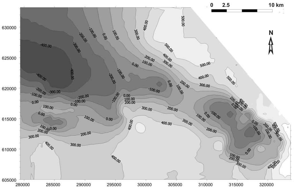
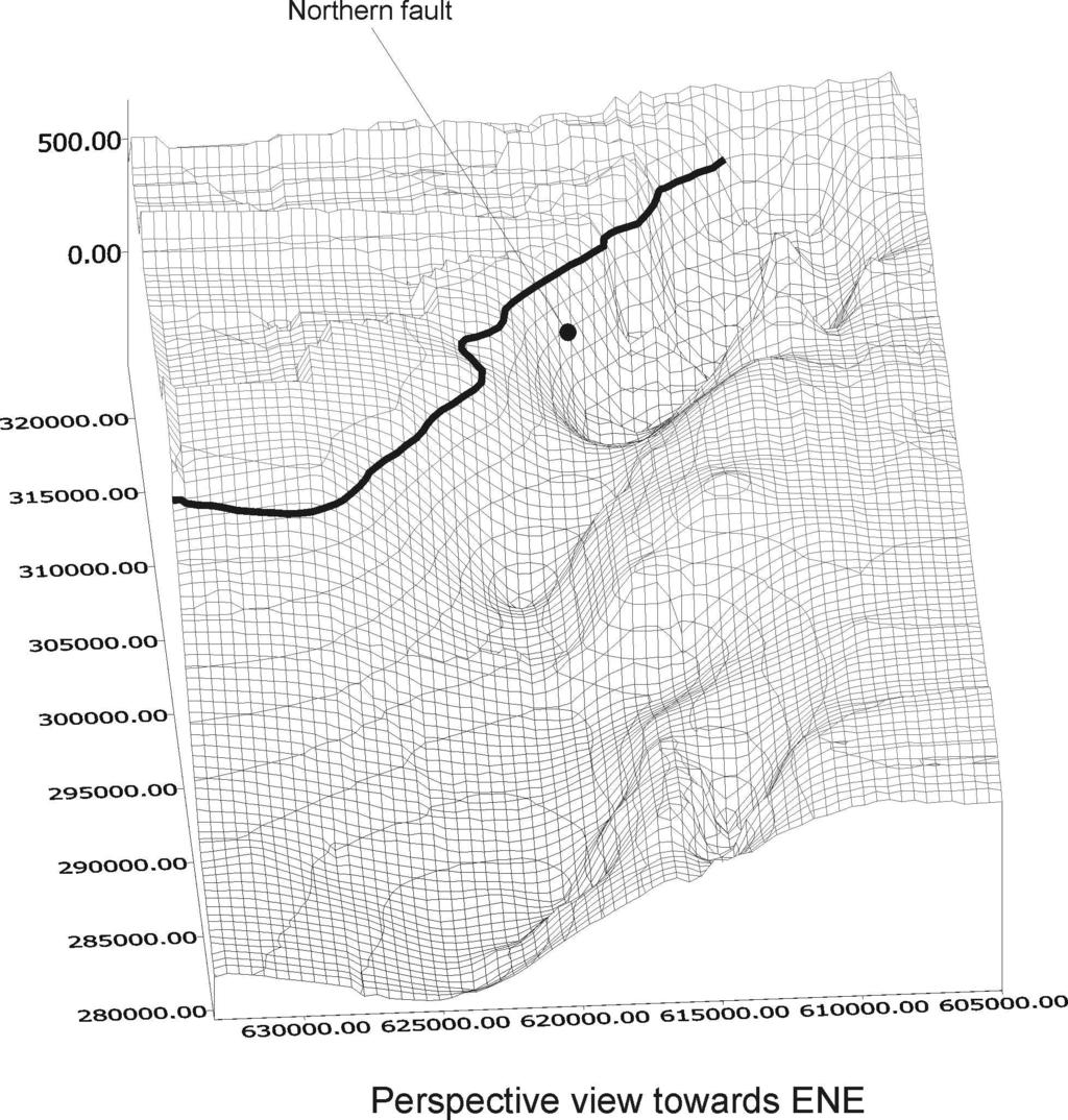
3 were made up digital elevation models (DEM) both for the basement and for the other lithostratigraphic formations. These models were realized using the SURFER software for Microsoft Windows, using the Kriger interpolation method. We chose this method for highlighting the morpho-structural features, given the working scale The 3D depiction of the pre-neogene basement (Fig. 3) highlights the existence of a major fault on the northern border of the basin, along of probably the basin has opened. The cross sections aligned longitudinally and transversally through the basin, made up based on the drill holes, shows some fault systems trending NW-SE (parallel with the main fault), and NE-SW. The marginal fault on the northern border of the basin separate the Neogene deposits by the metamorphics from the Plopis Mountains. Givulescu (1969) noticed the presence of a fault trending NE-SW, at the contact between the Neogene and Mesozoic deposits from Padurea Craiului Mountains. At the basement level, there is some lifted tectonic blocks praised by the electrometric investigations (Bădică & Dumitrescu, 1988). These blocks are generally stepping down towards of the west of the basin, precisely towards NW. Westward of Vadu Crisului and southward of Crisul Repede River (this river cuts the basin approximately on the middle), the paleo-landform is represented by the lower Cretaceous deposits. On the surfaces of these limestones has formed large ellipsoidal sinks with the long axis on the E-W direction (Petrescu et al., 1986). Generally, on the northern margin of the basin, eastwardly, the oldest and the thickest sediments come out. The drills from Grosi have met only the Sarmatian deposits with 600 m in thick without intercepting the basement (Nicorici et al., 1983). Probably the tectonic events that affected the northern part of the Apuseni, leads to a sequential forming of faults, but in the same time to the reactivation of those already opened, acting progressively on the Neogene cover. It formed thus a series of tectonic blocks with different elevation levels. As a concluding remark, we may say that the Borod Basin has opened along of a normal fault, probably listric (depicted by Kováč & Márton, 1998-fig. 4), positioned on the northern border of the basin. The enlargement of the basin took place progressively, as it is suggested by the presence of the oldest deposits only in the northern half of the basin. The Sarmatian and Pannonian deposits covers areas more and more larger towards the south and the west of the basin. Tectonic blocks from the western part of the basin are in the deeper position. Whole Neogene suite was affected by the fault systems mentioned before, fact that confirms the continuation in the Apuseni Mountains of the extensional events connected to TISZA-DACIA evolution in the regional geotectonic context.
4 REFERENCES Bădică A., Dumitrescu A., 1988: Prospecţiuni electrometrice pentru cărbuni în depozitele neogene din Depresiunea Vad-Borod, perimetrul Corniţel-Topa de Criş-Gheghie, jud. Bihor, Raport, arhiva Transgex, 2308, Cluj-Napoca. Csontos L., 1995: Tertiary tectonic evolution of the Intra - Carpathian area: a review. Acta Vulcanologica, 7 (2), p. 1-13, 11 fig. Givulescu R. 1969: Câteva observaţii privind alcătuirea subasmentului în porţiunea estică a bazinului Borod. Bul St. Inst. Pedag., I, p , 1 tab., 5 fig., Baia Mare. Györfi I., Csontos L., 1994: Structural evolution of SE Hungary and Neogene Basins of the Apuseni Mountains (Romania). Rom. Journal of Tectonics and Regional Geology, 75, Suppl. 1, Abstracts, p , Bucureşti. Kováč M., Márton E., 1998: To rotate or not to rotate: Palinspastic reconstruction of the Carpatho-Pannonian area during the Miocene. Slovak Geol. Mag. 4, 2 (1998), p , Bratislava. Nicorici E., Petrescu I., Nicorici M., 1983: Contribuţii la cunoaşterea depozitelor sarmaţiene din sectorul Groşi- Aştileu-Copăcel (Baz. Vad-Borod), pe baza datelor din foraje, Nymphaea, Muz. Ţării Criş., X, p.31-40, Oradea. Petrescu I., Nicorici E., Nicorici M., Simuţ D., 1986: Le rôle du paleokarst dans la genese des charbons de la partie ouest du bassin Vad - Borod, Studia, Univ. Babeş-Bolyai, Geol.-Geogr., 31, p.33-38, Cluj- Napoca. Popa M., 2000: Lithostratigraphy of the Miocene deposits in the eastern part of Borod Basin (north-western of Romania). Studia, Univ. Babeş-Bolyai, XLV/2, p , 5 fig., Cluj-Napoca. Fig. 1 Location of Borod Basin within Carpatho-Pannonian area. Fig. 2 The pre-neogene basement contour map. Fig. 3 Digital elevation model (3D block diagram) of the pre-neogene basement.

5
6
7
LITHOSTRATIGRAPHY OF THE MIOCENE DEPOSITS IN THE EASTERN PART OF BOROD BASIN (NORTH-WESTERN OF ROMANIA)
") STUDIA UNIVERSITATIS BABEŞ-BOLYAI, GEOLOGIA, XLV, 2, 2000 LITHOSTRATIGRAPHY OF THE MIOCENE DEPOSITS IN THE EASTERN PART OF BOROD BASIN (NORTH-WESTERN OF ROMANIA) MIRELA POPA 1 ABSTRACT. The paper presents
STUDIA UNIVERSITATIS BABEŞ-BOLYAI, GEOLOGIA, XLV, 2, 2000 LITHOSTRATIGRAPHY OF THE MIOCENE DEPOSITS IN THE EASTERN PART OF BOROD BASIN (NORTH-WESTERN OF ROMANIA) MIRELA POPA 1 ABSTRACT. The paper presents
1. Geological setting
 NEOGENE VOLCANISM IN OAS MTS., EASTERN CARPATHIANS, ROMANIA M. KOVACS and A. FULOP North University, 62A, V. Babes street, 4800 Baia Mare, Romania Abstract: Oas Mts., the northernmost part of Neogene volcanic
LIOTIA ORNATA N. SP. (MOLLUSCA, GASTROPODA) FROM BADENIAN OF BOROD BASIN (NW ROMANIA)
 FROM BADENIAN OF BOROD BASIN (NW ROMANIA)") STUDIA UNIVERSITATIS BABEŞ-BOLYAI, GEOLOGIA, XLVI, 2, 2001, 63-68 LIOTIA ORNATA N. SP. (MOLLUSCA, GASTROPODA) FROM BADENIAN OF BOROD BASIN (NW ROMANIA) MIRELA POPA 1 ABSTRACT. A new small-sized gastropod
STUDIA UNIVERSITATIS BABEŞ-BOLYAI, GEOLOGIA, XLVI, 2, 2001, 63-68 LIOTIA ORNATA N. SP. (MOLLUSCA, GASTROPODA) FROM BADENIAN OF BOROD BASIN (NW ROMANIA) MIRELA POPA 1 ABSTRACT. A new small-sized gastropod
TRANSPORT AND EMPLACEMENT OF IGNIMBRITES AND RESEDIMENTED VOLCANICLASTICS FROM GUTÂI MTS., EASTERN CARPATHIANS, ROMANIA
 STUDIA UNIVERSITATIS BABEŞ-BOLYAI, GEOLOGIA, XLIX, 1, 2004, 65-73 TRANSPORT AND EMPLACEMENT OF IGNIMBRITES AND RESEDIMENTED VOLCANICLASTICS FROM GUTÂI MTS., EASTERN CARPATHIANS, ROMANIA ALEXANDRINA FÜLÖP
THE ANALYSIS OF SUBSIDENCE ON THE FOREDEEP AREA OF THE EAST CARPATHIANS FORELAND BASIN, SUPERADJACENT TO THE BÂRLAD DEPRESSION CIRIMPEI CLAUDIA
 ANALELE ŞTIINŢIFICE ALE UNIVERSITĂŢII AL. I. CUZA IAŞI Geologie. Tomul LII, 2006 THE ANALYSIS OF SUBSIDENCE ON THE FOREDEEP AREA OF THE EAST CARPATHIANS FORELAND BASIN, SUPERADJACENT TO THE BÂRLAD DEPRESSION
Chapter 3. Geology & Tectonics
 Chapter 3 Geology & Tectonics 3.1 Geology The general geological features of Indonesia are shown in Figure 3.1. The basement formation is metamorphic and it is intruded with plutonic formations. They are
NATURAL ENVIRONMENT. Geophysics
 NATURAL ENVIRONMENT Geophysics Geodynamics Alpine, Carpathian and Dinaric mountain belts surround the Pannonian (Carpathian) Basin, of Neogene through Quaternary in age. The Cenozoic evolution of the Alpine-Pannonian
GEOLOGICAL AND HYDROGEOLOGICAL CONSIDERATIONS ON THE PHREATIC AQUIFER OF THE TARNAVA MICA RIVER FLOOD PLAIN AND TERRACES
 GEOLOGICAL AND HYDROGEOLOGICAL CONSIDERATIONS ON THE PHREATIC AQUIFER OF THE TARNAVA MICA RIVER FLOOD PLAIN AND TERRACES E. RADU 1, M. RADESCU, C. RADU, A. PANDELE, M. MINCIUNA ABSTRACT. Geological and
IDENTIFICATION OF THE SOURCE AREAS FOR THE PALEOGENE TURBIDITIC DEPOSITS OF THE PIENIDIAN UNITS IN MARAMURES
 STUDIA UNIVERSITATIS BABEŞ-BOLYAI, GEOLOGIA, XLVIII, 2, 2003, 51-58 IDENTIFICATION OF THE SOURCE AREAS FOR THE PALEOGENE TURBIDITIC DEPOSITS OF THE PIENIDIAN UNITS IN MARAMURES CARLO AROLDI 1 ABSTRACT.
We SRS1 11 3D Visualization of Miocene Tectonic Subsidence in the Northern and Central Vienna Basin Using BasinVis 1.0
 We SRS1 11 3D Visualization of Miocene Tectonic Subsidence in the Northern and Central Vienna Basin Using BasinVis 1.0 E.Y. Lee* (University of Vienna), J. Novotny (Brown University) & M. Wagreich (University
Tectonic position of the sandstone Cenozoic Uranium Deposit of Bulgaria
 Tectonic position of the sandstone Cenozoic Uranium Deposit of Bulgaria Radoslav Nakov Geological Institute, Bulgarian Academy of Sciences Pirin Mountain view from Eleshnitsa Mine 2915 m Technical meeting
Pleistocene alteration of drainage network and diverse surface morphology forced by basement structure in the foreland of the Eastern Alps
 This study was carried out in the framework of a project sponsored by the Hungarian National Science Foundation (OTKA NK83400) and TÁMOP-4.2.2/B-10/1-2010-0030 Pleistocene alteration of drainage network
Results of Preliminary Study of Shale Gas and Shale Oil Perspectives in Georgia
 World Experience in Shale Oil & Gas Industry and prospects of its Development in Georgia Results of Preliminary Study of Shale Gas and Shale Oil Perspectives in Georgia By: Archil Magalashvili Murman Margvelashvili
Geothermal Drilling for Space Heating in the Town of Szentlőrinc in SW Hungary
 Proceedings World Geothermal Congress 2010 Bali, Indonesia, 25-29 April 2010 Geothermal Drilling for Space Heating in the Town of Szentlőrinc in SW Hungary Ingunn María Thorbergsóttir 1, Helga Tulinius
Geologic Mapping Regional Tournament Trial Event
 Geologic Mapping Regional Tournament Trial Event A TEAM OF UP TO: 2 Team Name AVAILABLE TIME: 50 min Required Materials: Each team MUST have a protractor, ruler, non-programmable calculator, colored pencils,
Integrated well log and 3-D seismic data interpretation for the Kakinada area of KG PG offshore basin
 IOSR Journal of Applied Geology and Geophysics (IOSR-JAGG) e-issn: 2321 0990, p-issn: 2321 0982.Volume 5, Issue 4 Ver. II (Jul. Aug. 2017), PP 01-05 www.iosrjournals.org Integrated well log and 3-D seismic
Cenozoic Extensional Basin Development and Sedimentation in SW Montana
 Cenozoic Extensional Basin Development and Sedimentation in SW Montana Robert C. Thomas Department of Environmental Sciences, The University of Montana Western, Dillon, MT 59725, (406) 683-7615, r_thomas@umwestern.edu
Available online at Analele Stiintifice ale Universitatii Al. I. Cuza din Iasi Seria Geologie 59 (2) (2013) 61 68
 (2013) 61 68") Available online at http://geology.uaic.ro/auig/ Analele Stiintifice ale Universitatii Al. I. Cuza din Iasi Seria Geologie 59 (2) (2013) 61 68 AUI GEOLOGIE Lithostratigraphical characterization of the
Available online at http://geology.uaic.ro/auig/ Analele Stiintifice ale Universitatii Al. I. Cuza din Iasi Seria Geologie 59 (2) (2013) 61 68 AUI GEOLOGIE Lithostratigraphical characterization of the
of a two-dimensional numerical model of thermal source rock evolution; this model takes into account the kinetic evolution of nappes in the basin.
 ABSTRACT In the study The impications of belts overthrust from subasment of Comănești sedimentary basin in hydrocarbons generation we plan to address the issues related to generation of hydrocarbons in
POST-OROGENIC UPLIFT AND EROSION OF THE POLISH CARPATHIAN FOREDEEP CONSTRAINTS FROM COMPACTION ANALYSIS
 POST-OROGENIC UPLIFT AND EROSION OF THE POLISH CARPATHIAN FOREDEEP CONSTRAINTS FROM COMPACTION ANALYSIS P. POPRAWA 1, A. PELCZARSKI 2 and J. SZEWCZYK 1 1 Polish Geological Institute, ul. Rakowiecka 4,
PHYSICAL AND MECHANICAL PARAMETERS VARIATION, IN RELATION WITH DEPTH AND ENE-WSW ORIENTATION OF EPICLASTICAL SEDIMENTS
 ГОДИШНИК НА МИННО-ГЕОЛОЖКИЯ УНИВЕРСИТЕТ СВ. ИВАН РИЛСКИ, Том 48, Св. I, Геология и геофизика, 2005 ANNUAL OF THE UNIVERSITY OF MINING AND GEOLOGY ST. IVAN RILSKI, Vol. 48, Part I, Geology and Geophysics,
History of Exploration and Exploitation of Geothermal Energy in the Zagreb Geothermal Area (Croatia)
") Proceedings World Geothermal Congress 2010 Bali, Indonesia, 25-29 April 2010 History of Exploration and Exploitation of Geothermal Energy in the Zagreb Geothermal Area (Croatia) Miron Kovačić Croatian
Proceedings World Geothermal Congress 2010 Bali, Indonesia, 25-29 April 2010 History of Exploration and Exploitation of Geothermal Energy in the Zagreb Geothermal Area (Croatia) Miron Kovačić Croatian
Answers: Internal Processes and Structures (Isostasy)
") Answers: Internal Processes and Structures (Isostasy) 1. Analyse the adjustment of the crust to changes in loads associated with volcanism, mountain building, erosion, and glaciation by using the concept
Answers: Internal Processes and Structures (Isostasy) 1. Analyse the adjustment of the crust to changes in loads associated with volcanism, mountain building, erosion, and glaciation by using the concept
Structural Geology Lab. The Objectives are to gain experience
 Geology 2 Structural Geology Lab The Objectives are to gain experience 1. Drawing cross sections from information given on geologic maps. 2. Recognizing folds and naming their parts on stereoscopic air
Relation between time variation of gravity field and vertical surface movements in the Pannonian basin
 Relation between time variation of gravity field and vertical surface movements in the Pannonian basin L. Völgyesi Department of Geodesy and Surveying Budapest University of Technology and Economics, H521
CORALGAL FACIES OF THE UPPER EOCENE-LOWER OLIGOCENE LIMESTONES IN LETCA-RĂSTOCI AREA
 STUDIA UNIVERSITATIS BABEŞ-BOLYAI, GEOLOGIA, XLVI, 2, 2001, 53-61 CORALGAL FACIES OF THE UPPER EOCENE-LOWER OLIGOCENE LIMESTONES IN LETCA-RĂSTOCI AREA IOANA PRICA 1 ABSTRACT. In this paper are described
GLY 155 Introduction to Physical Geology, W. Altermann. Press & Siever, compressive forces. Compressive forces cause folding and faulting.
 Press & Siever, 1995 compressive forces Compressive forces cause folding and faulting. faults 1 Uplift is followed by erosion, which creates new horizontal surface. lava flows Volcanic eruptions cover
Pacific Northwest Rock Lab, Part II. Igneous Rocks. Name Per.
 Name Per. Pacific Northwest Rock Lab, Part II After you ve classified all your rocks, place their numbers next to the names and read the information about the rock. Check the classifications here (igneous,
Interpretation of Subsurface Geological Structure of Massepe Geothermal Area Using Resistivity Data
 Proceedings World Geothermal Congress 2010 Bali, Indonesia, 25-29 April 2010 Interpretation of Subsurface Geological Structure of Massepe Geothermal Area Using Resistivity Data Ahmad Zarkasyi and Yuanno
Pre-Feasibility Report
 Pre-Feasibility Report Project Details: The Block MB-OSN-2005/1 is a Saurashtra shallow water block situated between GS-OSN- 2003/1(NELP-V) in the west, C-37/C-43 PEL in the east and Saurashtra - Dahanu
Geology (Mellow) Hike, Santa Lucia Memorial Park February 16, I. Overview of Santa Lucia Range geology and tectonic history
 Hike, Santa Lucia Memorial Park February 16, I. Overview of Santa Lucia Range geology and tectonic history") Geology (Mellow) Hike, Santa Lucia Memorial Park February 16, 2015 I. Overview of Santa Lucia Range geology and tectonic history A. Basement Rocks 1. Salinian Block Rocks Sierra Nevada Type, continental
Geology (Mellow) Hike, Santa Lucia Memorial Park February 16, 2015 I. Overview of Santa Lucia Range geology and tectonic history A. Basement Rocks 1. Salinian Block Rocks Sierra Nevada Type, continental
Blocks 31, 32, 33, 34, 35 & 36/03 Southeast Offshore Vietnam
 Blocks 31, 32, 33, 34, 35 & 36/03 Southeast Offshore Vietnam Block 31 32 33 34 35 36/03 Area (km 2) 5,036 4,440 4,630 4,700 4,630 2,950 Sea level (m) 20 20-30 30-40 50 50 50 Seismic 2D (km) 1,294 685 431
Rocks and the Rock Cycle. Banded Iron Formation
 Rocks and the Rock Cycle Banded Iron Formation Rocks Big rocks into pebbles, Pebbles into sand. I really hold a million, million Rocks here in my hand. Florence Parry Heide How do rocks change? How are
Page 1. Name:
 Name: Questions 1 through 3 refer to the following: The diagrams below represent two rock outcrops found several miles apart in New York State. Individual rock layers are lettered, and fossils and rock
WP 2 Romanian Report. Romanian Storage Capacity
 WP 2 Romanian Report Romanian Storage Capacity EU GeoCapacity Final Conference, Copenhagen, 2122 October 2009 Content 1. Romanian Sedimentary Basins 2. CO 2 Storage Possibilities in Deep Saline Aquifers
Neotectonic Implications between Kaotai and Peinanshan
 Neotectonic Implications between Kaotai and Peinanshan Abstract Longitudinal Valley was the suture zone between the Philippine Sea plate and the Eurasia plate. Peinanshan was the southest segment of the
The Sorong Fault Zone Kinematics: The Evidence of Divergence and Horsetail Structure at NW Bird's Head and Salawati Basin, West Papua, Indonesia*
 The Sorong Fault Zone Kinematics: The Evidence of Divergence and Horsetail Structure at NW Bird's Head and Salawati Basin, West Papua, Indonesia* Putri Riadini 1 and Benyamin Sapiie 2 Search and Discovery
SPECIFIC THERMO-PLUVIOMETRIC FEATURES ON THE WESTERN MOUNTAINS SIDE OF WESTERN CARPATHIANS
 SPECIFIC THERMO-PLUVIOMETRIC FEATURES ON THE WESTERN MOUNTAINS SIDE OF WESTERN CARPATHIANS GHEORGHE MĂHĂRA 1 Key words: thermic anomalies, convection, orographical rainfall The thermo-pluviometric specific
EGAS. Ministry of Petroleum
 EGAS Ministry of Petroleum EGAS Ministry of Petroleum About The Block Location: N. El Arish offshore block is located in the extreme eastern part of the Egypt s economic water border and bounded from the
PROCEEDINGS, INDONESIAN PETROLEUM ASSOCIATION Thirty-Ninth Annual Convention and Exhibition, May 2015
 IPA15-SG-089 PROCEEDINGS, INDONESIAN PETROLEUM ASSOCIATION Thirty-Ninth Annual Convention and Exhibition, May 2015 STRUCTURAL INTERPRETATION OF TECTONICALLY ASSOCIATED NORMAL AND REVERSE FAULTS OF BUKIT
TRIASIC RUPTURE AND LIASIC MARINE INVASION IN THE LUSITANIAN BASIN (PORTUGAL) A SHIFT FROM TECTONIC TO THERMAL SUBSIDENCE
 A SHIFT FROM TECTONIC TO THERMAL SUBSIDENCE") TRIASIC RUPTURE AND LIASIC MARINE INVASION IN THE LUSITANIAN BASIN (PORTUGAL) A SHIFT FROM TECTONIC TO THERMAL SUBSIDENCE R.P. PENA dos REIS (1), N.L.V. PIMENTEL (2) & A.J.V. GARCIA (3) ATLANTIS (1) D.C.T.,
TRIASIC RUPTURE AND LIASIC MARINE INVASION IN THE LUSITANIAN BASIN (PORTUGAL) A SHIFT FROM TECTONIC TO THERMAL SUBSIDENCE R.P. PENA dos REIS (1), N.L.V. PIMENTEL (2) & A.J.V. GARCIA (3) ATLANTIS (1) D.C.T.,
Toshio MIZUTANI, Takeshi NAKAMURA and Keii BAN (1)
") Crushed Rock Mass in Landslide Body of the Cretaceous Sedimentary Rocks Toshio MIZUTANI, Takeshi NAKAMURA and Keii BAN (1) (1) Shikoku Branch, NIPPON KOEI CO., LTD. Abstract We have got an opportunity
Crushed Rock Mass in Landslide Body of the Cretaceous Sedimentary Rocks Toshio MIZUTANI, Takeshi NAKAMURA and Keii BAN (1) (1) Shikoku Branch, NIPPON KOEI CO., LTD. Abstract We have got an opportunity
SELECTION OF THE MOST SUCCESFUL NEURAL NETWORK ALGORITHM FOR THE PORPUSE OF SUBSURFACE VELOCITY MODELING, EXAMPLE FROM SAVA DEPRESSION, CROATIA
 SELECTION OF THE MOST SUCCESFUL NEURAL NETWORK ALGORITHM FOR THE PORPUSE OF SUBSURFACE VELOCITY MODELING, EXAMPLE FROM SAVA DEPRESSION, CROATIA Marko CVETKOVIĆ 1, Josipa VELIĆ 1 and Filip VUKIČEVIĆ 2 1
THE MAXIMUM QUANTITIES OF RAIN-FALL IN 24 HOURS IN THE CRIŞUL REPEDE HYDROGRAPHIC AREA
 Analele Universităţii din Oradea, Fascicula: Protecţia Mediului, Vol. XIII, 8 THE MAXIMUM QUANTITIES OF RAIN-FALL IN 24 HOURS IN THE CRIŞUL REPEDE HYDROGRAPHIC AREA *University of Oradea, Faculty of Environmental
TECHNICAL REPORT: REGIONAL GEOLOGY AND TECTONICS Resume. Huachon Project, Cerro de Pasco departments, Peru. By: AFC Logistic SAC
 TECHNICAL REPORT: REGIONAL GEOLOGY AND TECTONICS Resume Huachon Project, Cerro de Pasco departments, Peru By: AFC Logistic SAC December 2016 1. INTRODUCTION GPM Metals Peru, in its portfolio of generating
ESTIMATION OF SEDIMENT THICKNESS BY USING MICROTREMOR OBSERVATIONS AT PALU CITY, INDONESIA. Pyi Soe Thein. 11 November 2013
 ESTIMATION OF SEDIMENT THICKNESS BY USING MICROTREMOR OBSERVATIONS AT PALU CITY, INDONESIA By Pyi Soe Thein 11 November 2013 Outlines Introduction Research objectives Research analyses Microtremor Single
Structural Styles and Geotectonic Elements in Northwestern Mississippi: Interpreted from Gravity, Magnetic, and Proprietary 2D Seismic Data
 Structural Styles and Geotectonic Elements in Northwestern Mississippi: Interpreted from Gravity, Magnetic, and Proprietary 2D Seismic Data Nick Loundagin 1 and Gary L. Kinsland 2 1 6573 W. Euclid Pl.,
Potential Hydrocarbon Discoveries in Bjelovar Subdepression, Croatia By Tomislav Malvic 1 and Igor Rusan 2
 Potential Hydrocarbon Discoveries in Bjelovar Subdepression, Croatia By Tomislav Malvic 1 and Igor Rusan 2 Search and Discovery Article #10133 (2007) Posted September 25, 2007 1 INA-Industrija nafte, d.d.,
coosi 3^COMMONWEALTH OP AUSTRALIA
 1940 coosi 3^COMMONWEALTH OP AUSTRALIA DEPARTMENT OF NATIONAL DEVELOPMENT BUREAU OF MINERAL RESOURCES GEOLOGY AND GEOPHYSICS RECORDS: $966/54 019564 REPORT ON PHOTO INTERPRETATION OF MILLUNGERA 1:250,000
RELINQUISHMENT REPORT. License P1546 Block April 2009
 RELINQUISHMENT REPORT License P1546 Block 110-01 14 April 2009 Sherritt International Oil and Gas Limited 2000, 425-1 st street S.W., Calgary, Alberta Canada T2P 3L8 Telephone (403) 260-2900 Fax (403)
II. REGIONAL GEOLOGY
 II. REGIONAL GEOLOGY 2.1. Regional Plate Tectonic Setting The geological history of the East Java basin is closely related to tectonic activity of the Southeast Asia especially the Western Indonesia region.
UNDERSTANDING GEOLOGIC M APS
 Name: Lab Section: work in groups, but each person turns in his/her own GEOSCIENCE 001 L AB UNDERSTANDING GEOLOGIC M APS Geologic maps are colorful and even beautiful, but they also contain an amazing
High-resolution Sequence Stratigraphy of the Glauconitic Sandstone, Upper Mannville C Pool, Cessford Field: a Record of Evolving Accommodation
 Page No. 069-1 High-resolution Sequence Stratigraphy of the Glauconitic Sandstone, Upper Mannville C Pool, Cessford Field: a Record of Evolving Accommodation Thérèse Lynch* and John Hopkins, Department
EGAS. Ministry of Petroleum
 EGAS Ministry of Petroleum EGAS Ministry of Petroleum About The Block Location: N. Thekah offshore block is located at about 56 km to the north of the Mediterranean shore line, 85 km to the north west
Structural Style and Tectonic Evolution of the Nakhon Basin, Gulf of Thailand
 Structural Style and Tectonic Evolution of the Nakhon Basin, Gulf of Thailand Piyaphong Chenrai Petroleum Geoscience Program, Department of Geology, Faculty of Science, Chulalongkorn University, Bangkok
BALOCHISTAN FOLDBELT BASIN
 INTRODUCTION BALOCHISTAN FOLDBELT BASIN The Kharan-3 block is located in the Kharan Trough of Balochistan Basin. GEOLOGICAL SETTING The Balochistan Province is an Upper Cretaceous to Recent structurally
In this lab, we will study and analyze geologic maps from a few regions, including the Grand Canyon, western Wyoming, and coastal California.
 Name: Lab Section: work in groups, but each person turns in his/her own GEOSCIENCE 001 LAB UNDERSTANDING GEOLOGIC MAPS Geologic maps are colorful and even beautiful, but they also contain an amazing amount
Block 43B - Onshore Oman
 Block 43B - Onshore Oman SUMMARY Block 43B is an 11,967 km 2 area located along the coastal area of Oman north of the Hajar Mountains. This is an unexplored region, both geographically and stratigraphically.
Airborne gravity gradiometer surveying of petroleum systems under Lake Tanganyika, Tanzania
 Airborne gravity gradiometer surveying of petroleum systems under Lake Tanganyika, Tanzania D. Roberts Beach Energy P. Roy Chowdhury CGG S. J. Lowe CGG A. N. Christensen CGG Outline Introduction Geology
Module 10: Resources and Virginia Geology Topic 4 Content: Virginia Geology Notes
 Virginia is composed of a very diverse landscape that extends from the beaches and barrier islands all of the way to the highly elevated Appalachian Plateau. Geologists have discovered ancient shallow
Continental Landscapes
 Continental Landscapes Landscape influenced by tectonics, climate & differential weathering Most landforms developed within the last 2 million years System moves toward an equilibrium Continental Landscapes
IRAQ. Target Exploration. Geodynamic Evolutions of The Sedimentary Basins of. This study is a major reference for Petroleum
 barr Target Exploration Target Exploration Geodynamic Evolutions of The Sedimentary Basins of IRAQ This study is a major reference for Petroleum Explorationists on the tectonics, stratigraphy, sedimentary
The Mesozoic. Wednesday, November 30, 11
 The Mesozoic Periods of the Mesozoic Triassic- First period of the Mesozoic era Jurassic Cretaceous- Last period of the Mesozoic era Breakup of Pangaea Stage one (Triassic) Rifting and volcanism, normal
University of Leeds 3GP Geophysics Field Trip Lake Balaton, Hungary
 University of Leeds 3GP Geophysics Field Trip Lake Balaton, Hungary September 1-15, 2007 geological background and logistics Staff: Greg Houseman, Graham Stuart The Alpine-Carpathian-Pannonian System Elevation
Depositional History and Petroleum Potential of Ombilin Basin, West Sumatra - Indonesia, Based on Surface Geological Data*
 Depositional History and Petroleum Potential of Ombilin Basin, West Sumatra - Indonesia, Based on Surface Geological Data* Yahdi Zaim 1, Litto Habrianta 2, Chalid I. Abdullah 1, Aswan 1, Yan Rizal 1, Nurcahyo
EAS 233 Geologic Structures and Maps Winter Miscellaneous practice map exercises. 1. Fault and separation:
 Miscellaneous practice map exercises 1. Fault and separation: With respect to Map 1, what are (a) the orientation of the fault, and (b) the orientation of bedding in the units cut by the fault. (c) Mark
The Welsh Borderland. Geologically recent surface deposits. The Welsh Borderland
 The Welsh Borderland This account provides a broad perspective of the geology of the Welsh Borderland region which comprises the southeast of Powys, southern Shropshire, northern Gwent, the western half
Sequence Stratigraphy of the Upper Cretaceous Niobrara Formation, A Bench, Wattenberg Field, Denver Julesburg Basin, Colorado*
 Sequence Stratigraphy of the Upper Cretaceous Niobrara Formation, A Bench, Wattenberg Field, Denver Julesburg Basin, Colorado* Lisa E. Remington LaChance 1 and Mark C. Robinson 1 Search and Discovery Article
Bulletin of Earth Sciences of Thailand. Evaluation of the Petroleum Systems in the Lanta-Similan Area, Northern Pattani Basin, Gulf of Thailand
 Evaluation of the Petroleum Systems in the Lanta-Similan Area, Northern Pattani Basin, Gulf of Thailand Sirajum Munira Petroleum Geoscience Program, Department of Geology, Faculty of Science, Chulalongkorn
Sediment and sedimentary rocks Sediment
 Sediment and sedimentary rocks Sediment From sediments to sedimentary rocks (transportation, deposition, preservation and lithification) Types of sedimentary rocks (clastic, chemical and organic) Sedimentary
Investigation of Devonian Unconformity Surface Using Legacy Seismic Profiles, NE Alberta
 Investigation of Devonian Unconformity Surface Using Legacy Seismic Profiles, NE Alberta Elahe P. Ardakani and Douglas R. Schmitt Department of Physics, University of Alberta Summary The Devonian Grosmont
Lateral extrusion and tectonic escape in Ilan Plain of northeastern Taiwan
 Lateral extrusion and tectonic escape in Ilan Plain of northeastern Taiwan Angelier, J., Chang, T.Y., Hu, J.C., Chang, C.P., Siame, L., Lee, J.C., Deffontaines, B., Chu, H.T, Lu, C.Y., Does extrusion occur
Structural Analysis and Tectonic Investigation of Chamshir Dam Site, South West Zagros
 Open Journal of Geology, 2015, 5, 136-143 Published Online March 2015 in SciRes. http://www.scirp.org/journal/ojg http://dx.doi.org/10.4236/ojg.2015.53013 Structural Analysis and Tectonic Investigation
DECIPNERING DIFFERENTIAL UPLIFT IN SHLLONG PLATEAU USING REMOTE SENSING
 SHORT COMMUNICATlON DECIPNERING DIFFERENTIAL UPLIFT IN SHLLONG PLATEAU USING REMOTE SENSING Geological Survey of India, Tripura-Mizoram Division, B.K. Road, Banamalipur, Agartala - 790 001 Email: v+srinivasan_geo
Deep geological structures as revealed by 3D gravity stripping: western part of the Moesian Platform, Romania
 JOURNAL OF BALKAN GEOPHYSICAL SOCIETY, Vol.8, No 3, August 2005, p.129-138 Deep geological structures as revealed by 3D gravity stripping: western part of the Moesian Platform, Romania D. Ioane*, C. Calota*,
Structure of the western Brooks Range fold and thrust belt, Arctic Alaska
 Trabajos de Geología, Universidad de Oviedo, 29 : 218-222 (2009) Structure of the western Brooks Range fold and thrust belt, Arctic Alaska J. DE VERA 1* AND K. MCCLAY 2 1Now at: Shell, Rijswijk, Netherlands.
Fault History analysis in Move
 Fault History analysis in Move The new Fault History plot in Move provides a method to conduct a quick-look analysis of the evolution of faults through time. By restoring the vertical displacement of a
Construction of Subsurface Geological Structures Using a Drilling Database: A Case Study for an Intra-Arc Basin, the Osaka Plain, Southwest Japan
 Open Journal of Geology, 2013, 3, 39-43 http://dx.doi.org/10.4236/ojg.2013.32006 Published Online April 2013 (http://www.scirp.org/journal/ojg) Construction of Subsurface Geological Structures Using a
Play fairway mapping in the Northeast Atlantic Margin Comparison between mature and immature basins. David Mudge, Joanne Cranswick
 Play fairway mapping in the Northeast Atlantic Margin Comparison between mature and immature basins David Mudge, Joanne Cranswick Contents Ternan North Sea Play fairway mapping Tertiary case study Northeast
Beneath the sand of the Tanami Desert
 Beneath the sand of the Tanami Desert ARGA 2018, Wallaroo, SA Nadir de Souza Kovacs Ngururrpa program The program area covers the traditional land of the Parna Ngururrpa People in a remote part of the
THERMAL MATURITY ASSESSMENT OF MIDDLE ROCKS AND HEAT FLOW MODELING IN AGATOVO-SUHINDOL AREA (CENTRAL NORTH BULGARIA)
") DOI: http://dx.doi.org/10.18509/agb.2015.01 UDC: 551.761:550.832.6.05(497.2) COBISS: THERMAL MATURITY ASSESSMENT OF MIDDLE TRIASSIC ROCKS AND HEAT FLOW MODELING IN AGATOVO-SUHINDOL AREA (CENTRAL NORTH
DOI: http://dx.doi.org/10.18509/agb.2015.01 UDC: 551.761:550.832.6.05(497.2) COBISS: THERMAL MATURITY ASSESSMENT OF MIDDLE TRIASSIC ROCKS AND HEAT FLOW MODELING IN AGATOVO-SUHINDOL AREA (CENTRAL NORTH
SPATIAL COHERENCY OF GROUND MOTIONS FOR EMBEDDED STRUCTURES
 4 th International Conference on Earthquake Geotechnical Engineering June 25-28, 2007 Paper No. 1499 SPATIAL COHERENCY OF GROUND MOTIONS FOR EMBEDDED STRUCTURES Melanie WALLING 1, & Norman ABRAHAMSON 2
PETROMETALLOGENIC UNITS RELATED TO MAGMATIC DOMAIN-DISTINGUISHING CRITERIA
 PETROMETALLOGENIC UNITS RELATED TO MAGMATIC DOMAIN-DISTINGUISHING CRITERIA MARZA 1 Ioan, KOVACS 2 Marinel 1 Babes Bolyai University, 3400 Cluj Napoca, 11, Avram Iancu str., e-mail: ioanmarza@personal.ro
Figure 1. Examples of vector displacement diagrams for two and three-plate systems.
 Figure 1. Examples of vector displacement diagrams for two and three-plate systems. Figure 2. Relationships between pole of rotation, great circles, ridge segments, small circles, transforms and fracture
EVALUATION OF AQUIFER CHARACTERISTICS FOR SELECTED NEW METHOD OF THE UM RUWABA FORMATION: NORTH KORDOFAN STATE, SUDAN
 EVALUATION OF AQUIFER CHARACTERISTICS FOR SELECTED NEW METHOD OF THE UM RUWABA FORMATION: NORTH KORDOFAN STATE, SUDAN ELHAGA.B *1; ELZIENS.M*2 ANDLISSANN.H*3 *1Department of C i v i l E n g i n e e r i
Biostratigraphic and Lithostratigraphic Correlation of Sedimentary Strata in the Atlantic Coastal Plain
 Biostratigraphic and Lithostratigraphic Correlation of Sedimentary Strata in the Atlantic Coastal Plain Introduction to the Atlantic Coastal Plain (Please read this page prior to doing the lab) The Atlantic
SEQUENCE STRATIGRAPHY OF THE COAL BEARING OTTNANGIAN (?) - KARPATHIAN SEDIMENT SERIES IN THE EAST BORSOD BASIN (N-HUNGARY)
 - KARPATHIAN SEDIMENT SERIES IN THE EAST BORSOD BASIN (N-HUNGARY)") SEQUENCE STRATIGRAPHY OF THE COAL BEARING OTTNANGIAN (?) - KARPATHIAN SEDIMENT SERIES IN THE EAST BORSOD BASIN (N-HUNGARY) Z. PÜSPÖKI, M. KOZÁK, L. VINCZE and R. MCINTOSH University of Debrecen, Department
SEQUENCE STRATIGRAPHY OF THE COAL BEARING OTTNANGIAN (?) - KARPATHIAN SEDIMENT SERIES IN THE EAST BORSOD BASIN (N-HUNGARY) Z. PÜSPÖKI, M. KOZÁK, L. VINCZE and R. MCINTOSH University of Debrecen, Department
Structural Deformation and Karst in the Devonian Waterways Formation: Examples from Outcrops along the Athabasca River*
 Structural Deformation and Karst in the Devonian Waterways Formation: Examples from Outcrops along the Athabasca River* Chris L. Schneider 1 and Matthias Grobe 2 Search and Discovery Article #51073 (2015)
Basin & Range / Mojave Desert
 Basin & Range / Mojave Desert Basin & Range vs. Great Basin 1 2/20/2016 An overview of the last horst Basin and Range / Mojave Desert Summary: Granitic, volcanic, marine sedimentary, non marine sedimentary,
Summary. Introduction
 Orthogonal geometrics of lower McMurray Formation sand complexes: effects of salt dissolution collapse-subsidence across the northern Athabasca oil sands deposit Paul L. Broughton, Chevron Canada Resources,
Sedimentary Rocks. Origin, Properties and Identification. Physical Geology GEOL 101 Lab Ray Rector - Instructor
 Sedimentary Rocks Origin, Properties and Identification Physical Geology GEOL 101 Lab Ray Rector - Instructor Sedimentary Rock Origin and Identification Lab Pre-Lab Internet Link Resources 1) http://www.rockhounds.com/rockshop/rockkey/index.html
454/01 GEOLOGY GL4 INTERPRETING THE GEOLOGICAL RECORD. P.M. THURSDAY, 17 June (2 Hours)
") Candidate Name Centre Number Candidate Number WELSH JOINT EDUCATION COMMITTEE General Certificate of Education Advanced CYD-BWYLLGOR ADDYSG CYMRU Tystysgrif Addysg Gyffredinol Uwch 454/01 GEOLOGY GL4 INTERPRETING
Candidate Name Centre Number Candidate Number WELSH JOINT EDUCATION COMMITTEE General Certificate of Education Advanced CYD-BWYLLGOR ADDYSG CYMRU Tystysgrif Addysg Gyffredinol Uwch 454/01 GEOLOGY GL4 INTERPRETING
Why is it called the "Inland Basins" Region?
 Learning Series: Rocks of the Southeastern U. S. The BIG Picture Why is it called the "Inland Basins" Region? Inland from the mountains, the Earth s crust was buckled (downwarped) into a series of depressions
Sedimentary Cycle Best Practice: Potential Eo-Oligocene Sediments in Western Indonesia*
 Sedimentary Cycle Best Practice: Potential Eo-Oligocene Sediments in Western Indonesia* Mellinda Arisandy 1 and I Wayan Darma 1 Search and Discovery Article #11008 (2017)** Posted November 6, 2017 *Adapted
Integrated Interpretation of Gravity, Magnetic & Seismic data for delineation of Basement Configuration in Sadiya Block, Upper Assam, India
 P-225 Integrated Interpretation of Gravity, Magnetic & Seismic data for delineation of Basement Summary G.K.Ghosh *, S.K.Basha, V.K. Kulshreshth Gravity and magnetic data were collected jointly by National
BUREAU OF MINERAL RESOURCES, GEOLOGY AND GEOPHYSICS
 COMMONWEALTH OF AUSTRALIA DEPARTMENT OF NATIONAL DEVELOPMENT BUREAU OF MINERAL RESOURCES, GEOLOGY AND GEOPHYSICS RECORD No. 1952/35 PRELIMINARY REPORT ON SEISMIC REFLECTION SURVEY, AVON AREA, GIPPSLAND,
Geothermal exploration using MT and gravity techniques at Szentlõrinc area in Hungary
 KMS Technologies KJT Enterprises, Inc. An EMGS/RXT company Geothermal exploration using MT and gravity techniques at Szentlõrinc area in Hungary Yu, G., He, Z. X., Hu, Z. Z., Ϸorbergsdóttir, I. M., Strack,
Rock mechanics as a significant supplement for cross-section balancing (an example from the Pavlov Hills, Outer Western Carpathians, Czech Republic)
") Trabajos de Geología, Universidad de Oviedo, 30 : 140-144 (2010) Rock mechanics as a significant supplement for cross-section balancing (an example from the Pavlov Hills, Outer Western Carpathians, Czech
Trabajos de Geología, Universidad de Oviedo, 30 : 140-144 (2010) Rock mechanics as a significant supplement for cross-section balancing (an example from the Pavlov Hills, Outer Western Carpathians, Czech
Appendix 11. Geology. of the. I60 area
 Appendix 11 Geology of the I60 area 1. Locality The locality of the I60 area is as follows; Northwestern corner; UTM_EW 530513, UTM_NS 7345741 Southwestern corner; UTM_EW 530418, UTM_NS 7301454 Northeastern
Correlations between some small hydrographic basins of the Rivers tributaries, from the forestry fund
 Volume 16(2), 84-89, 2012 JOURNAL of Horticulture, Forestry and Biotechnology www.journal-hfb.usab-tm.ro Correlations between some small hydrographic basins of the Rivers tributaries, from the forestry