Welcome to Vibrationdata
|
|
|
- Marsha Banks
- 6 years ago
- Views:
Transcription


1 Welcome to Vibrationdata Acoustics Shock Vibration Signal Processing January 2005 Newsletter Megathrust Earthquake Disaster Feature Article We are very saddened to learn about the devastating earthquake that struck Indonesia's Sumatra Island, on December 26. The confirmed death toll was 141,000 as of January 2, 2005, according to a CNN report. Most of the fatalities were due to tsunamis throughout the Indian Ocean. This number will increase as additional bodies are recovered. Furthermore, millions of homeless survivors are at risk of diseases such as cholera, pneumonia and malaria. Many of the refugees are suffering from lack of food and clean water. The Sumatra earthquake was the largest in terms of magnitude since the 1964 Prince William Sound, Alaska earthquake. The Sumatra earthquake was the most deadly natural disaster since China's Tangshan quake killed at least a quarter of a million in Please make a generous donation to the Red Cross or to other disaster relief organizations. Sincerely, Tom Irvine tomirvine@aol.com Northern Sumatra Earthquake and Tsunami 1

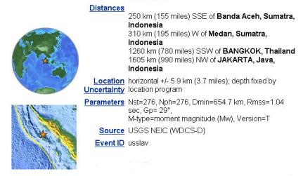
2 2

3 3

4 Courtesy of British Geological Survey The epicenter of the 26 December 2004 earthquake is marked by the star. The 70 associated aftershocks are marked by red circles. These markers show the approximate length of the rupture zone. The red line indicates the plate boundary between the Indian and Asian plates. 4

5 Courtesy of British Geological Survey This map shows the direction of motion of the Indian Plate relative to Eurasia. The length of the arrows shows the rate of convergence. 5

6 Death tolls as of January 1, Image courtesy of BBC. 6

7 Seismograms 7

8 Seismograms of the earthquake as recorded on BGS seismometers in the UK. 8
9 Preliminary Earthquake Report U.S. Geological Survey, National Earthquake Information Center World Data Center for Seismology, Denver The devastating megathrust earthquake of December 26, 2004, occurred on the interface of the India and Burma plates and was caused by the release of stresses that develop as the India plate subducts beneath the overriding Burma plate. The India plate begins its descent into the mantle at the Sunda trench, which lies to the west of the earthquake's epicenter. The trench is the surface expression of the plate interface between the Australia and India plates, situated to the southwest of the trench, and the Burma and Sunda plates, situated to the northeast. In the region of the earthquake, the India plate moves toward the northeast at a rate of about 6 cm/year relative to the Burma plate. This results in oblique convergence at the Sunda trench. The oblique motion is partitioned into thrustfaulting, which occurs on the plate-interface and which involves slip directed perpendicular to the trench, and strike-slip faulting, which occurs several hundred kilometers to the east of the trench and involves slip directed parallel to the trench. The December 26 earthquake occurred as the result of thrust-faulting. Preliminary locations of larger aftershocks following the megathrust earthquake show that approximately 1200 km of the plate boundary slipped as a result of the earthquake. By comparison with other large megathrust earthquakes, the width of the causative fault-rupture was likely over one-hundred km. From the size of the earthquake, it is likely that the average displacement on the fault plane was about fifteen meters. The sea floor overlying the thrust fault would have been uplifted by several meters as a result of the earthquake. The above estimates of fault-dimensions and displacement will be refined in the near future as the result of detailed analyses of the earthquake waves. The world's largest recorded earthquakes have all been megathrust events, occurring where one tectonic plate subducts beneath another. These include: 1. The magnitude Chile earthquake 2. The magnitude Prince William Sound, Alaska, earthquake 3. The magnitude Andreanof Islands, Alaska, earthquake 4. The magnitude Kamchatka earthquake As with the recent event, megathrust earthquakes often generate large tsunamis that cause damage over a much wider area than is directly affected by ground shaking near the earthquake's rupture. 9
10 Tsunami Introduction by Tom Irvine Tsunami is the Japanese word for harbor wave. A tsunami may be generated by an underwater disturbance from a volcano, earthquake, or severe landslide. A large meteor impacting the ocean could also cause a tsunami. Earthquakes are the primary source, however. A tsunami is also referred to as a seismic sea wave. The seafloor may experience an abrupt or pulsating displacement during an earthquake. This causes a vertical displacement in the water column above the seafloor. A tsunami is generated as the water is pulled back to its equilibrium condition by gravity. The potential energy of the water column is transformed to kinetic energy of the waves. Tsunamis have extremely long periods, from 2 minutes to over one hour. A tsunami in the deep ocean may have a length of over 100 miles (160 km) from wave crest to crest. The wave may propagate as speeds up to 500 mph (800 km/hr). In contrast, a typical wind-generated swell at a surf beach has a period of about 10 seconds and a wavelength of 500 feet (150 m). The amplitude or height of the tsunami may only be a few feet over the deep ocean. The amplitude increase sharply as the wave reaches shallow zones near coastlines. The wave speed decreases, however. The tsunami speed v is v = gd where g is gravity and d is the depth. The wavelength λ is λ = v T where T is the period. The speed slows in shallow depths due to frictional effects between the water and the seafloor. Most tsunamis do not create giant breaking waves on shore. Rather they generate fast tides that cause a rapid sea level rise, particularly as the tsunami reaches a shallow harbor. 10
.")
11 The following images are courtesy of the USGS. Panel 1 Initiation The potential energy that results from pushing water above mean sea level is transferred to horizontal propagation of the tsunami wave (kinetic energy). For the case shown above, the earthquake rupture occurred at the base of the continental slope in relatively deep water. Situations can also arise where the earthquake rupture occurs beneath the continental shelf in much shallower water. Note: In the figure the waves are greatly exaggerated compared to water depth. In the open ocean, the waves are at most, several meters high spread over many tens to hundreds of kilometers in length. Panel 2 Split Within several minutes of the earthquake, the initial tsunami (Panel 1) is split into a tsunami that travels out to the deep ocean (distant tsunami) and another tsunami that travels towards the nearby coast (local tsunami). The height above mean sea level of the two oppositely traveling tsunamis is approximately half that of the original tsunami (Panel 1). (This is somewhat modified in three dimensions, but the same idea holds.) The speed at which both tsunamis travel varies as the square root of the water depth. Therefore the deep-ocean tsunami travels faster than the local tsunami near shore. 11
12 Panel 3--Amplification Several things happen as the local tsunami travels over the continental slope. Most obvious is that the amplitude increases. In addition, the wavelength decreases. This results in steepening of the leading wave--an important control of wave run-up at the coast (next panel). Note also that the deep ocean tsunami has traveled much farther than the local tsunami because of the higher propagation speed. As the deep ocean tsunami approaches a distant shore, amplification and shortening of the wave will occur, just as with the local tsunami shown above. Panel 4 Run-up Tsunamis continue after reaching land. After run-up, part of the tsunami energy is reflected back to the open ocean. In addition, a tsunami can generate a particular type of wave called edge waves that travel back-and forth, parallel to shore. These effects result in many arrivals of the tsunami at a particular point on the coast rather than a single wave suggested by Panel 3. The first run-up of a tsunami is often not the largest due to the complicated behavior of tsunami waves near the coast, emphasizing the importance of not returning to a beach several hours after a tsunami hits. 12
.")
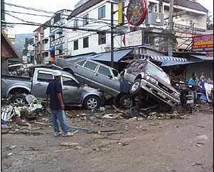
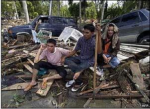
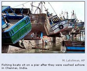
13 Sumatra Earthquake Tsunami Tourists, fishermen, homes and cars were swept away by walls of water that propagated across the Bay of Bengal, generated by the magnitude 9.0 earthquake. The tsunami that struck Sri Lanka had an amplitude of 30 feet (9.1 meters). Roland Buerk, a reporter in Unawatuna, Sri Lanka, wrote that he and his associates were swept along by the wave for a few hundred meters, trying to dodge the motorcycles, refrigerators, cars and other debris that were coming with us. The tsunami also struck Maldives, an archipelago of 1,190 low-lying coral islands, dotted across hundreds of miles of the Indian Ocean. The average height of these islands is 3 feet (1 meter). Waves swept completely across many of these islands. The waves extended over as much as half of Male, a relatively large island of 0.7 square miles pouring down the narrow, sandy streets and dashing against buildings including the president's office. 13


14 A British family filmed the tsunami coming ashore at Thailand's Phuket resort. 14

15 15


16 Photo Gallery 16

17 17

18 18
19 News Reports BANGKOK, Thailand (AP) -- Knowledge of the ocean and its currents passed down from generation to generation of a group of Thai fishermen known as the Morgan sea gypsies saved an entire village from the Asian tsunami, a newspaper said Saturday. By the time killer waves crashed over southern Thailand last Sunday the entire 181 population of their fishing village had fled to a temple in the mountains of South Surin Island, English language Thai daily The Nation reported. "The elders told us that if the water recedes fast it will reappear in the same quantity in which it disappeared," 65-year-old village chief Sarmao Kathalay told the paper. So while in some places along the southern coast, Thais headed to the beach when the sea drained out of beaches -- the first sign of the impending tsunami -- to pick up fish left flapping on the sand, the gypsies headed for the hills. Few people in Thailand have a closer relationship with the sea than the Morgan sea gypsies, who spend each monsoon season on their boats plying the waters of the Andaman Sea from India to Indonesia and back to Thailand. Between April and December, they live in shelters on the shore surviving by catching shrimp and spear fishing. At boat launching festivals each May, they ask the sea for forgiveness. 19


20 Excerpts from: Seeking Survivors on Swallowed Islands By Amitabh Bhattasali, BBC Giant tsunami waves struck the Andaman and Nicobar archipelago and devastated most of the southern islands. Indian air force officers said that some of these islands like Katchall had simply vanished, no longer visible from the air. "We can't find the islands from the coordinates we have," said one, who asked not to be identified. 20


21 Excerpts from: Deserted Aceh in Ruins By Jonathan Head BBC It's New Year's Day and I'm in a town I know well from many, many visits in the past but today I hardly recognise it. This is Banda Aceh, which six days ago bore the full brunt of the tsunamis that tore into this part of the island of Sumatra. The damage is astounding. Just at the end of this road is a square I used to go to join hundreds of Acehnese families who would eat together in the evenings from different stalls selling food there. That is completely destroyed and bizarrely there is an enormous wooden fishing boat that has been hurled into the centre of the square by the force of the waves, from the port which is at least a kilometre away. 21

22 Statistics for Worldwide Earthquakes since 1900 USGS Questions and Answers Question: What effect did this earthquake have on the rotation of the earth? Answer: Richard Gross at JPL has modeled the coseismic effect on the Earth's rotation of the December 26 earthquake in Indonesia by using the PREM model for the elastic properties of the Earth and the Harvard centroid-moment tensor solution for the source properties of the earthquake. The result is: change in length of day: microseconds polar motion excitation X : milliarcseconds polar motion excitation Y: milliarcseconds Since the length of the day can be measured with an accuracy of about 20 microseconds, this model predicts that the change in the length-of-day caused by the earthquake is much too small to be observed. And, since the location of the earthquake was near the equator, this model predicts that the change in polar motion excitation is also rather small, being about 0.82 milliarcsecond in amplitude. Such a small change in polar motion excitation will also be difficult to detect. 22
News Release December 30, 2004 The Science behind the Aceh Earthquake
 News Release December 30, 2004 The Science behind the Aceh Earthquake PASADENA, Calif. - Kerry Sieh, the Robert P. Sharp Professor of Geology at the California Institute of Technology and a member of Caltech's
We have previously looked at artificial seismograms such as this one here.
 We have previously looked at artificial seismograms such as this one here. S P A realistic Seismic Record Each vertical line = 1 minute Each horizontal line = 15 minutes Seismic station PMM is in Parkfield,
Earthquakes Physical Geology 2017 Part 1: Exploring Earthquake distributions. Home butto California Earthquakes: 1) 2) 3) above
 2) 3) above") Earthquakes Physical Geology 2017 Adapted from a lab by Jennifer Wenner This lab is designed to give you experience exploring seismicity associated with different plate boundaries. You will examine seismograms
Earthquakes Physical Geology 2017 Adapted from a lab by Jennifer Wenner This lab is designed to give you experience exploring seismicity associated with different plate boundaries. You will examine seismograms
Earthquake Hazards. Tsunami
 Earthquake Hazards Tsunami Review: What is an earthquake? Earthquake is the vibration (shaking) and/or displacement of the ground produced by the sudden release of energy. The point inside the Earth where
Earthquake Hazards. Tsunami
 Earthquake Hazards Tsunami Measuring Earthquakes Two measurements that describe the power or strength of an earthquake are: Intensity a measure of the degree of earthquake shaking at a given locale based
Magnitude 7.6 SOUTH OF IQUIQUE, CHILE
 A powerful aftershock struck off northern Chile prompting an evacuation of the coastal area and raising fears of a tsunami. This magnitude 7.6 earthquake is the largest of a series of aftershocks following
Magnitude 8.2 NORTHWEST OF IQUIQUE, CHILE
 An 8.2-magnitude earthquake struck off the coast of northern Chile, generating a local tsunami. The USGS reported the earthquake was centered 95 km (59 miles) northwest of Iquique at a depth of 20.1km
Earthquake Hazards. Tsunami
 Earthquake Hazards Tsunami Review: What is an earthquake? Earthquake is the vibration (shaking) and/or displacement of the ground produced by the sudden release of energy. The point inside the Earth where
Earthquakes 11/14/2014. Earthquakes Occur at All Boundaries. Earthquakes. Key Aspects of an Earthquake. Epicenter. Focus
 Earthquakes Earthquakes Caused by friction and movement between Earth s tectonic plates A release of force Often caused by a catch between two plates As plates slide by, they stick to each other When the
Name: Date: Bell: The Sumatra Earthquake and Tsunami December 26, 2004
 Name: Date: Bell: The Sumatra Earthquake and Tsunami December 26, 2004 Introduction: The incredible damage and tragic loss of life resulting from the 9.0 magnitude earthquake and ensuing tsunami was shocking
Tsunami waves swept away houses and cars in northern Japan and pushed ships aground.
 Japan was struck by a magnitude 8.9 earthquake off its northeastern coast Friday. This is one of the largest earthquakes that Japan has ever experienced. In downtown Tokyo, large buildings shook violently
Magnitude 7.1 PHILIPPINES
 A magnitude 7.1 earthquake struck in the southeastern Philippines just after 8 am local time Tuesday morning killing 82 people and reducing a 17 th century church to rubble. Offices and schools were closed
1.3 Short Review: Preliminary results and observations of the December 2004 Great Sumatra Earthquake Kenji Hirata
 1.3 Short Review: Preliminary results and observations of the December 2004 Great Sumatra Earthquake Kenji Hirata We give a brief review about observations and preliminary results regarding the 2004 great
Tsunami! Beyond the Book. FOCUS Book
 FOCUS Book Use the engineering design process to design a structure that will protect a coastal town from possible tsunami damage. Brainstorm design ideas for your structure with a group of classmates.
Lessons from the 2004 Sumatra earthquake and the Asian tsunami
 Lessons from the 2004 Sumatra earthquake and the Asian tsunami Kenji Satake National Institute of Advanced Industrial Science and Technology Outline 1. The largest earthquake in the last 40 years 2. Tsunami
Disclaimer. This report was compiled by an ADRC visiting researcher (VR) from ADRC member countries.
 from ADRC member countries.") Disclaimer This report was compiled by an ADRC visiting researcher (VR) from ADRC member countries. The views expressed in the report do not necessarily reflect the views of the ADRC. The boundaries and
Disclaimer This report was compiled by an ADRC visiting researcher (VR) from ADRC member countries. The views expressed in the report do not necessarily reflect the views of the ADRC. The boundaries and
Three Fs of earthquakes: forces, faults, and friction. Slow accumulation and rapid release of elastic energy.
 Earthquake Machine Stick-slip: Elastic Rebound Theory Jerky motions on faults produce EQs Three Fs of earthquakes: forces, faults, and friction. Slow accumulation and rapid release of elastic energy. Three
Tsunami Seismic Sea Wave. Dr. Wan Zuhairi Wan Yaacob Program Geologi, UKM
 Tsunami Seismic Sea Wave soo-nah-mee Dr. Wan Zuhairi Wan Yaacob Program Geologi, UKM the breaking wave off Kanagawa wood block color print the event s surface wave magnitude, Ms. Historical map of 731
Magnitude 7.7 QUEEN CHARLOTTE ISLANDS REGION
 A major 7.7 magnitude earthquake struck at 8:04 PM local time in western British Columbia, Canada. The epicenter is located on Moresby Island, the southern large island in the Queen Charlotte Islands region.
Indian Ocean Tsunami Warning System: Example from the 12 th September 2007 Tsunami
 Indian Ocean Tsunami Warning System: Example from the 12 th September 2007 Tsunami Charitha Pattiaratchi 1 Professor of Coastal Oceanography, The University of Western Australia Email: chari.pattiaratchi@uwa.edu.au
Magnitude 6.5 OFFSHORE NORTHERN CALIFORNIA
 A powerful offshore earthquake that struck near the Northern California coast left a hodgepodge of debris for communities to sort through Sunday but spared residents any serious injury. After 25,000 people
Earthquakes = shaking of Earth because of a rapid release of energy
 There are more than 30,000 earthquakes worldwide each year! Earthquakes = shaking of Earth because of a rapid release of energy usually because of movement of tectonic plates Most earthquakes last for
Magnitude 7.0 PAPUA, INDONESIA
 A 7.0 magnitude earthquake struck eastern Indonesia's mountainous West Papua province on Saturday but there were no immediate reports of casualties or damage. The region is sparsely populated. According
Plate Tectonics IDEA THAT EARTH S SURFACE IS BROKEN INTO PLATES THAT MOVE AROUND. Fault = fracture in the crust where the movement has occurred
 Warm-up #14 A mountain range found 100 meters above sea level is measured to be 1,000 meters high from its tallest peak. From the top, the first 500 meters are incredibly steep. After this point, the mountain
Chapter 4 Earthquakes and Tsunamis
 Geology of the Hawaiian Islands Class 21 30 March 2004 100 100 100 96 A B C D F Exam Scores 95 94 94 90 85 83 83 83 Mean 72 67 61 59 59 55 54 41 Mean = 78.5 Median = 83 Any Questions? Chapter 4 Earthquakes
Chapter 4 Earthquakes and Tsunamis. Geology of the Hawaiian Islands. Any Questions? Class March Mean = 78.
 Geology of the Hawaiian Islands Class 21 30 March 2004 Any Questions? 100 100 100 96 A B C D F Exam Scores 95 94 94 90 85 83 83 83 Mean 72 67 61 59 59 55 54 41 Mean = 78.5 Median = 83 Chapter 4 Earthquakes
Sendai Earthquake NE Japan March 11, Some explanatory slides Bob Stern, Dave Scholl, others updated March
 Sendai Earthquake NE Japan March 11, 2011 Some explanatory slides Bob Stern, Dave Scholl, others updated March 14 2011 Earth has 11 large plates and many more smaller ones. Plates are 100-200 km thick
Magnitude 7.0 N of ANCHORAGE, ALASKA
 A magnitude 7.0 earthquake occurred just before 8:30 am local time 8 miles north of Anchorage at a depth of 40.9 km (25.4 miles). There are reports of major infrastructure damage and damage to many homes
Mw 7.8, Southwest of Sumatra, Indonesia Wed, 2 March 2016 at 12:49:48 UTC M /03/03
 Earthquake overview AFGHANISTA N PAKISTA N INDIA A moment magnitude (Mw) 7.8 earthquake struck in South West, Indonesia. The epicentre was centered about 800 km West South West of Padang, Sumatra province,
Magnitude 7.5 NEW BRITAIN REGION, PAPUA NEW GUINEA
 A magnitude 7.5 earthquake struck off the eastern coast of Papua New Guinea on Tuesday, approximately 130 km (81 mi) southsouthwest of Kokopo at a depth of 42 km (26.1 mi). There are reports of some structural
Warm-up #15. How does magma move throughout the mantle? What is another example of this movement in nature?
 Warm-up #15 How does magma move throughout the mantle? What is another example of this movement in nature? Earth s Structure Lithosphere = crust & upper mantle; tectonic plates Asthenosphere = lower mantle
What is an Earthquake?
 Earthquakes What is an Earthquake? Earthquake - sometimes violent shaking of ground caused by movement of Earth s tectonic plates; creates seismic waves Often followed by smaller earthquakes (aftershocks);
Magnitude 7.5 NEW BRITAIN REGION, PAPUA NEW GUINEA
 A magnitude 7.5 earthquake struck off the eastern coast of Papua New Guinea on Sunday, approximately 54 km (33 miles) southeast of Kokopo. Residents reported strong ground shaking for about five minutes.
Tsunami Risk Mitigation Strategy for Thailand. Kjell Karlsrud Norwegian Geotechnical Institute (NGI)
") Tsunami Risk Mitigation Strategy for Thailand Kjell Karlsrud Norwegian Geotechnical Institute (NGI) The project was undertaken by NGI in cooperation with: NORSAR, UiB, UiO, NIBR, B.Heyerdahl, NTNU, Sintef
Tsunami Risk Mitigation Strategy for Thailand Kjell Karlsrud Norwegian Geotechnical Institute (NGI) The project was undertaken by NGI in cooperation with: NORSAR, UiB, UiO, NIBR, B.Heyerdahl, NTNU, Sintef
The Earthquake of Padang, Sumatra of 30 September 2009 scientific information and update
 The Earthquake of Padang, Sumatra of 30 September 2009 scientific information and update 01-October-2009 Christophe Vigny Directeur de recherches at CNRS Laboratoire de Géologie Geoscience Dept. Of ENS,
Tsunamis. Visit for thousands of books and materials. A Reading A Z Level S Leveled Reader Word Count: 889
 Tsunamis A Reading A Z Level S Leveled Reader Word Count: 889 LEVELED READER S Written by Shaun Taylor Visit www.readinga-z.com for thousands of books and materials. www.readinga-z.com Photo Credits: Front
The Indian Ocean. Copyright 2010 LessonSnips
 The Indian Ocean One of the five major geographic divisions of the world s ocean, the Indian Ocean is located in the Eastern Hemisphere. The Indian Ocean is bounded by three continents: Africa to the west,
Introduction to Environmental Geology, 5e Case History: Indonesian Tsunami Indonesian Tsunami (2) Introduction Historic Tsunamis
 Introduction Historic Tsunamis") 1 2 3 4 5 6 7 8 9 Introduction to Environmental Geology, 5e Chapter 7 Tsunami Case History: Indonesian Tsunami December 26, 2004, within a few hours, close to 250,000 people were killed With no warning
1 2 3 4 5 6 7 8 9 Introduction to Environmental Geology, 5e Chapter 7 Tsunami Case History: Indonesian Tsunami December 26, 2004, within a few hours, close to 250,000 people were killed With no warning
Preparation for Future Earthquake and Tsunami Hazards: Lessons Learned from the 2004 Sumatra-Andaman Earthquake and the Asian Tsunami
 First International Conference of Aceh and Indian Ocean Studies Organized by Asia Research Institute, National University of Singapore & Rehabilitation and Construction Executing Agency for Aceh and Nias
What causes a tsunami?
 Listen: Have this page read to you [1] Have this page read to you [2] A tsunami is a series of waves in the sea caused by a movement on the sea floor. New Zealand is at risk from tsunami because it has
Unit 9 (packet #2): Volcanoes and Earthquakes
: Volcanoes and Earthquakes") Unit 9 (packet #2): Volcanoes and Earthquakes 13. Earthquakes are one of the most destructive natural forces. I can a. Explain what an earthquake is, where they occur and why they occur. b. Describe the
Unit 9 (packet #2): Volcanoes and Earthquakes 13. Earthquakes are one of the most destructive natural forces. I can a. Explain what an earthquake is, where they occur and why they occur. b. Describe the
An Earthquake is a rapid vibration or shaking of the Earth s crust created by a release in energy from sudden movement of a part of a plate along a
 An Earthquake is a rapid vibration or shaking of the Earth s crust created by a release in energy from sudden movement of a part of a plate along a fault. Energy released radiates in all directions from
Tsunamis and ocean waves
 Department of Mathematics & Statistics AAAS Annual Meeting St. Louis Missouri February 19, 2006 Introduction Tsunami waves are generated relatively often, from various sources Serious tsunamis (serious
Geology Topics. Unit 6 Notes
 Geology Topics Unit 6 Notes Composition of the Earth Earth is layered due to density differences. Crust thin outer layer, solid, made up of continental and oceanic crust Mantle rocky layer below the crust
Science Starter. Describe in your own words what an Earthquake is and what causes it. Answer The MSL
 Science Starter Describe in your own words what an Earthquake is and what causes it. Answer The MSL WHAT IS AN EARTHQUAKE AND HOW DO WE MEASURE THEM? Chapter 8, Section 8.1 & 8.2 Looking Back Deserts Wind-shaped
Tsunamis. A Large-Scale Earth and Ocean Phenomenon. Satish R Shetye
 Tsunamis A Large-Scale Earth and Ocean Phenomenon Satish R Shetye Tsunamis are surface gravity waves that are triggered due to perturbation of the ocean floor. The tsunamis that occurred in the Indian
7.1 FIJI 1, :57:22 UTC
 A magnitude 7.1 earthquake struck 141 km (88 miles) northeast of Ndoi Island, Fiji, and 313 km (194 mi) west-northwest of Nuku alofa, Tonga according to the US Geological Survey, but there were no reports
Module 2, Investigation 1: Earthquake Hazards
 Module 2, Investigation 1: Earthquake Hazards Introduction Welcome! In the last module, you assumed the role of a volcanologist and learned how volcanoes are described and monitored. You will now assume
Earthquakes & Volcanoes
 Earthquakes & Volcanoes Geology - the study of solid Earth, the rocks of which it is composed, and the processes by which they change geo = Earth; ology = study of Earth s Layers Plate Tectonics - the
Magnitude 7.1 NEAR THE EAST COAST OF HONSHU, JAPAN
 Japan was rattled by a strong aftershock and tsunami warning Thursday night nearly a month after a devastating earthquake and tsunami flattened the northeastern coast. This earthquake can be considered
Earthquakes. Building Earth s Surface, Part 2. Science 330 Summer What is an earthquake?
 Earthquakes Building Earth s Surface, Part 2 Science 330 Summer 2005 What is an earthquake? An earthquake is the vibration of Earth produced by the rapid release of energy Energy released radiates in all
Magnitude 7.6 & 7.4 SOLOMON ISLANDS
 A magnitude 7.6 earthquake struck near the Solomon Islands on Sunday morning local time; there were no immediate reports of damage. The earthquake was centered 100 km (60 miles) south of Kira Kira, a town
9.3. Earthquakes. Earthquakes at Divergent Boundaries
 9.3 Earthquakes Preview the headings on these two pages. What can you say about where earthquakes occur? As the plates that make up Earth s crust move, the rough edges lock together. Over time, pressure
Introduction to Environmental Geology, 5e
 Lecture Presentation prepared by X. Mara Chen, Salisbury University Introduction to Environmental Geology, 5e Edward A. Keller Chapter 7 Tsunami Case History: Indonesian Tsunami December 26, 2004, within
Earthquakes and Earthquake Hazards Earth - Chapter 11 Stan Hatfield Southwestern Illinois College
 Earthquakes and Earthquake Hazards Earth - Chapter 11 Stan Hatfield Southwestern Illinois College What Is an Earthquake? An earthquake is the vibration of Earth, produced by the rapid release of energy.
Magnitude 7.9 SE of KODIAK, ALASKA
 A magnitude 7.9 earthquake occurred at 12:31 am local time 181 miles southeast of Kodiak at a depth of 25 km (15.5 miles). There are no immediate reports of damage or fatalities. Light shaking from this
Running Head: JAPANESE TSUNAMI 1. Geological Perspective of the Japanese Tsunami
 Running Head: JAPANESE TSUNAMI 1 Geological Perspective of the Japanese Tsunami JAPANESE TSUNAMI 2 JAPANESE TSUNAMI 3 Abstract Humanity is characterized with flaws, so is planet earth. Earthquakes shake
Quake in Indonesia. A series of earthquakes strike the island nation.
 Quake in Indonesia A series of earthquakes strike the island nation. A series of earthquakes rocked the Indonesian island of Sumatra in Southeast Asia. On March 6, 2007, a 6.3-magnitude 1 quake destroyed
Section Forces Within Earth. 8 th Grade Earth & Space Science - Class Notes
 Section 19.1 - Forces Within Earth 8 th Grade Earth & Space Science - Class Notes Stress and Strain Stress - is the total force acting on crustal rocks per unit of area (cause) Strain deformation of materials
Magnitude 7.2 OAXACA, MEXICO
 A magnitude 7.2 earthquake has occurred in Oaxaca, Mexico at a depth of 24.6 km (15 miles). It was felt as far away as Guatemala. There have been no reported deaths directly linked to the earthquake. Emergency
Earthquakes and Earth s Interior
 - What are Earthquakes? Earthquakes and Earth s Interior - The shaking or trembling caused by the sudden release of energy - Usually associated with faulting or breaking of rocks - Continuing adjustment
Magnitude 8.3 SEA OF OKHOTSK
 A powerful earthquake in Russia's Far East was felt as far away as Moscow, about 7,000 kilometers (4,400 miles) west of the epicenter, but no casualties or damage were reported. The epicenter was in the
An Analysis of the Events of 26 December 2004 to Plan for the Future
 An Analysis of the Events of 26 December 2004 to Plan for the Future SATISH R SHETYE An analysis of the data collected on 26 December, 2004, should help us understand the series of events that followed
Tectonic Forces Simulation: Earthquakes Activity One
 Tectonic Forces Simulation: Earthquakes Activity One Introduction If you marked all the earthquakes from the past century on a world map, you'd notice that most tend to occur along certain lines around
Dynamic Crust Practice
 1. Base your answer to the following question on the cross section below and on your knowledge of Earth science. The cross section represents the distance and age of ocean-floor bedrock found on both sides
Chapter 15. Earthquakes and Plate Tectonics. what s the connection? At the boundaries friction causes plates to stick together.
 Chapter 15 Earthquakes and Plate Tectonics what s the connection? As with volcanoes, earthquakes are not randomly distributed over the globe At the boundaries friction causes plates to stick together.
Magnitude 7.0 SOUTH ISLAND OF NEW ZEALAND
 A powerful 7.0-magnitude earthquake shook much of New Zealand's South Island early Saturday morning local time. USGS A damaged building near Manchester St. New Zealand Herald Photo / Colin Cross A car
Magnitude 7.5 PALU, INDONESIA
 A magnitude 7.5 earthquake occurred 80.8 km (50.2 mi) north of Palu, Indonesia at a depth of 10 km (6.2 miles). This earthquake triggered a tsunami with wave heights up to 2 m (6.6 ft) that an official
Dynamic Earth A B1. Which type of plate boundary is located at the Jordan Fault? (1) divergent (3) convergent (2) subduction (4) transform
 divergent (3) convergent (2) subduction (4) transform") Dynamic Earth A B1 1. The edges of most lithospheric plates are characterized by (1) reversed magnetic orientation (2) unusually rapid radioactive decay (3) frequent volcanic activity (4) low P-wave and
Dynamic Earth A B1 1. The edges of most lithospheric plates are characterized by (1) reversed magnetic orientation (2) unusually rapid radioactive decay (3) frequent volcanic activity (4) low P-wave and
Name Date Class. radiate in all directions, carrying some of the. of plate boundaries have different usual patterns of.
 Chapter Outline Earthquakes CHAPTER 6 Lesson 1: Earthquakes and Plate Boundaries A. What is an earthquake? 1. A(n) is the rupture and sudden movement of rocks along a fault. A fault is a fracture surface
Earthquakes Earth, 9th edition, Chapter 11 Key Concepts What is an earthquake? Earthquake focus and epicenter What is an earthquake?
 1 2 3 4 5 6 7 8 9 10 Earthquakes Earth, 9 th edition, Chapter 11 Key Concepts Earthquake basics. "" and locating earthquakes.. Destruction resulting from earthquakes. Predicting earthquakes. Earthquakes
Earthquakes. Written by: Lillie Hamstick
 Earthquakes Written by: Lillie Hamstick Table of Contents Meeting an Earthquake. 1 Dangerous Destruction.. 2 Exciting Earthquakes 3 Yo, What Causes an Earthquake... 4 Where Are You Earthquake. 5 How to
Advisors: Arcadii Grinshpan, Mathematics and Statistics Rocco Malservisi, School of Geosciences. Problem Suggested By: Rocco Malservisi
 Undergraduate Journal of Mathematical Modeling: One + Two Volume 8 2018 Spring 2018 Issue 2 Article 6 Tsunami Waves Samantha Pennino University of South Florida Advisors: Arcadii Grinshpan, Mathematics
Forces in Earth s Crust
 Name Date Class Earthquakes Section Summary Forces in Earth s Crust Guide for Reading How does stress in the crust change Earth s surface? Where are faults usually found, and why do they form? What land
Earthquake. earthquake, epicenters in the U.S. Kobe, Japan deaths
 Kobe, Japan 1995 5000 deaths Earthquakes It is estimated that there are 500,000 detectable earthquakes in the world each year. 100,000 of those can be felt, and 100 of them cause damage. The world's deadliest
Magnitude 7.0 PERU. This region of the Andes is a sparsely populated area, there were no immediate reports of injuries or damage.
 A magnitude 7.0 earthquake occurred in southeastern Peru on Friday about 27 kilometers northeast of the town of Azángaro, Peru, near the border with Bolivia. The earthquake occurred at a depth of 257.4
UGRC 144 Science and Technology in Our Lives/Geohazards
 UGRC 144 Science and Technology in Our Lives/Geohazards Session 3 Understanding Earthquakes and Earthquake Hazards Lecturer: Dr. Patrick Asamoah Sakyi Department of Earth Science, UG Contact Information:
Magnitude 8.2 FIJI. A magnitude 8.2 earthquake occurred km (226.7 mi) E of Suva, Fiji at a depth of km (350 miles).
 E of Suva, Fiji at a depth of km (350 miles).") A magnitude 8.2 earthquake occurred 364.8 km (226.7 mi) E of Suva, Fiji at a depth of 563.4 km (350 miles). There is no risk of a tsunami from an earthquake at this depth. Images courtesy of Google The
A magnitude 8.2 earthquake occurred 364.8 km (226.7 mi) E of Suva, Fiji at a depth of 563.4 km (350 miles). There is no risk of a tsunami from an earthquake at this depth. Images courtesy of Google The
Assessment Schedule 2015 Earth and Space Science: Demonstrate understanding of the causes of extreme Earth events in New Zealand (91191)
") NCEA Level 2 Earth and Space Science (91191) 2015 page 1 of 6 Assessment Schedule 2015 Earth and Space Science: Demonstrate understanding of the causes of extreme Earth events in New Zealand (91191) Evidence
NCEA Level 2 Earth and Space Science (91191) 2015 page 1 of 6 Assessment Schedule 2015 Earth and Space Science: Demonstrate understanding of the causes of extreme Earth events in New Zealand (91191) Evidence
Natural Hazards Classwork Classwork #1
 Natural Hazards Classwork Classwork #1 Name: 4 th Grade PSI The Alps are the highest mountain range in Europe. They span eight different countries: Italy, Slovenia, Switzerland, Monaco, Liechtenstein,
Magnitude 6.3 SOUTH ISLAND OF NEW ZEALAND
 A magnitude 6.3 earthquake shook the southern New Zealand city of Christchurch. At least 100 people are reported dead, and there are reports of collapsed buildings, cracked streets and flooding due to
"The Big One" by sea and not by land
 "The Big One" by sea and not by land By Los Angeles Times, adapted by Newsela staff on 03.24.14 Word Count 629 Surfer Lee Johnson emerges from the water at San Onofre State Beach, Calif., with the twin
Mondo Quake in Pacific Northwest? By Leander Kahney
 Introduction to College Reading D Natural Disasters: Earthquake NAME I. Pre-reading. Discuss the following topics with other students at your table. What countries or regions of the world have earthquakes?
Magnitude 7.3 NEPAL. Tuesday, May 12, 2015 at 07:05:19 UTC
 A magnitude 7.3 earthquake has occurred near Mount Everest. Early reports suggest 32 people have been killed and at least 1,000 were injured in the earthquake. The region is still in recovery from a 7.8
Seismic Activity near the Sunda and Andaman Trenches in the Sumatra Subduction Zone
 IJMS 2017 vol. 4 (2): 49-54 International Journal of Multidisciplinary Studies (IJMS) Volume 4, Issue 2, 2017 DOI: http://doi.org/10.4038/ijms.v4i2.22 Seismic Activity near the Sunda and Andaman Trenches
Section 19.1: Forces Within Earth Section 19.2: Seismic Waves and Earth s Interior Section 19.3: Measuring and Locating.
 CH Earthquakes Section 19.1: Forces Within Earth Section 19.2: Seismic Waves and Earth s Interior Section 19.3: Measuring and Locating Earthquakes Section 19.4: Earthquakes and Society Section 19.1 Forces
RR#8 - Free Response
 Base your answers to questions 1 through 4 on the passage and the map below and on your knowledge of Earth science. The map indicates the epicenter (*) of a major earthquake that occurred at 38 N 142 E.
Magnitude 7.0 VANUATU
 A major earthquake struck in the southwest Pacific Ocean at a depth of 27 km beneath the island of Melampa in the Vanuatu island chain. There are no reports of damage. The Modified Mercalli Intensity (MMI)
Lecture Outline Wednesday-Monday April 18 23, 2018
 Lecture Outline Wednesday-Monday April 18 23, 2018 Questions? Lecture Final Exam Lecture Section 1 Friday May 4, 8:00-10:00am Lecture Section 2 Friday May 4, 3:10-5:10 pm Final Exam is 70% new material
GEOLOGY MEDIA SUITE Chapter 13
 UNDERSTANDING EARTH, SIXTH EDITION GROTZINGER JORDAN GEOLOGY MEDIA SUITE Chapter 13 Earthquakes 2010 W.H. Freeman and Company Three different types of seismic waves are recorded by seismographs Key Figure
GNH7/GG09/GEOL4002 EARTHQUAKE SEISMOLOGY AND EARTHQUAKE HAZARD
 Tectonics Lecture 10 Global Seismotectonics Rigid plate translation A Map of the World s Fracture Zones Magnetic anomalies and fracture zones form the basic building blocks for the construction of isochron
Chapter 13 Earthquakes and Earth s Interior
 Chapter 13 Earthquakes and Earth s Interior The crust of the Earth is made up of floating tectonic plates- huge continent-sized chunks of solid rock floating on molten rock. Rock masses along the boundaries
Earthquakes Chapter 19
 Earthquakes Chapter 19 Does not contain complete lecture notes. What is an earthquake An earthquake is the vibration of Earth produced by the rapid release of energy Energy released radiates in all directions
Magnitude 7.3 OFFSHORE EL SALVADOR
 A magnitude 7.3 earthquake struck off the Pacific coast of Central America late Monday night, early reports indicate one death. The earthquake occurred at a depth of 40 km (24.9 miles). Its epicenter was
COMING TO A SHORELINE NEAR YOU? Not Your Ordinary Wave
 COMING TO A SHORELINE NEAR YOU? Modelling of the lost tsunami of 8000 yr BP* Not Your Ordinary Wave * yr BP means radiocarbon years before 1950 Lost tsunami ~ 8,000 yr B.P. The tsunami was triggered by
Earth Science Lesson 3 Dynamic Earth Processes (Grades 8-12 ) Instruction 3-3 Plate Boundaries
 Instruction 3-3 Plate Boundaries") As we told you in a recent Instruction, much of the Earth's lithosphere (its Crust and the top layer of its Outer Mantle) is made up of moving masses of rock called tectonic plates (tectonic means moving).
As we told you in a recent Instruction, much of the Earth's lithosphere (its Crust and the top layer of its Outer Mantle) is made up of moving masses of rock called tectonic plates (tectonic means moving).
A. rift valley B. deep trench C. volcanic cone D. uplifted mountain. A. a volcanic island arc B. a large watershed area
 DC Practice Test Dynamic Crust PRCTICE TEST Zimm's Earth Science 2013 1. Which feature would most likely be forming at converging continental tectonic plate boundaries?. rift valley. deep trench C.
Natural Disasters. Why Are There Earthquakes? 197 words. The Power of the Earth 221 words. Big Waves! 188 words
 ARTICLE-A-DAY Natural Disasters 6 Articles Check articles you have read: Why Are There Earthquakes? 197 words The Power of the Earth 221 words Big Waves! 188 words The Volcano That Keeps Erupting 228 words
A magnitude 7.8 earthquake has occurred km (63.3 mi) ESE of Suva, Fiji at a depth of km (378 miles).
 ESE of Suva, Fiji at a depth of km (378 miles).") A magnitude 7.8 earthquake has occurred 101.8 km (63.3 mi) ESE of Suva, Fiji at a depth of 608.6 km (378 miles). There is no risk of a tsunami from an earthquake at this depth. Images courtesy of Google
A magnitude 7.8 earthquake has occurred 101.8 km (63.3 mi) ESE of Suva, Fiji at a depth of 608.6 km (378 miles). There is no risk of a tsunami from an earthquake at this depth. Images courtesy of Google
Plates & Boundaries The earth's continents are constantly moving due to the motions of the tectonic plates.
 Plates & Boundaries The earth's continents are constantly moving due to the motions of the tectonic plates. As you can see, some of the plates contain continents and others are mostly under the ocean.