Crustal architecture and geodynamics of North Queensland, Australia: insights from deep seismic reflection profiling
|
|
|
- Cecily Wells
- 6 years ago
- Views:
Transcription

.")
1 University of Wollongong Research Online Faculty of Science, Medicine and Health - Papers Faculty of Science, Medicine and Health 2012 Crustal architecture and geodynamics of North Queensland, Australia: insights from deep seismic reflection profiling R J. Korsch Geoscience Australia D L. Huston Geoscience Australia R A. Henderson James Cook University R S. Blewett Geoscience Australia I W. Withnall Geological Survey of Queensland See next page for additional authors Publication Details Korsch, R. J., Huston, D. L., Henderson, R. A., Blewett, R. S., Withnall, I. W., Fergusson, C. L., Collins, W. J., Saygin, E., Kositcin, N., Meixner, A. J., Chopping, R., Henson, P. A., Champion, D. C., Hutton, L. J., Wormald, R., Holzschuh, J. & Costelloe, R. D. (2012). Crustal architecture and geodynamics of North Queensland, Australia: insights from deep seismic reflection profiling. Tectonophysics, (N/A), Research Online is the open access institutional repository for the University of Wollongong. For further information contact the UOW Library: research-pubs@uow.edu.au
2 Crustal architecture and geodynamics of North Queensland, Australia: insights from deep seismic reflection profiling Abstract A deep crustal seismic reflection and magnetotelluric survey, conducted in 2007, established the architecture and geodynamic framework of north Queensland, Australia. Results based on the interpretation of the deep seismic data include the discovery of a major, west-dipping, Paleoproterozoic (or older) crustal boundary, considered to be an ancient suture zone, separating relatively nonreflective, thick crust of the Mount Isa Province from thinner, two layered crust to the east. Farther to the east, a second major crustal boundary also dips west or southwest, offsetting the Moho and extending below it, and is interpreted as a fossil subduction zone. Across the region, the lower crust is mostly highly reflective and is subdivided into three mappable seismic provinces, but they have not been tracked to the surface. In the east, the Greenvale and Charters Towers Provinces, part of the Thomson Orogen, have been mapped on the surface as two discrete provinces, but the seismic interpretation raises the possibility that these two provinces are continuous in the subsurface, and also extend northwards to beneath the Hodgkinson Province, originally forming part of an extensive Neoproterozoic-Cambrian passive margin. Continuation of the Thomson Orogen at depth beneath the Hodgkinson and Broken River Provinces suggests that these provinces (which formed in an oceanic environment, possibly as an accretionary wedge at a convergent margin) have been thrust westwards onto the older continental passive margin. The Tasman Line, originally defined to represent the eastern limit of Precambrian rocks in Australia, has a complicated geometry in three dimensions, which is related to regional deformational events during the Paleozoic. Overall, the seismic data show evidence for a continental margin with a long history (Paleoproterozoic to early Mesozoic) but showing only limited outward growth by crustal accretion, because of a repeated history of overthrust shortening during repeated phases of orogenesis. Keywords crustal, insights, geodynamics, seismic, reflection, profiling, architecture, deep, north, queensland, australia Publication Details Korsch, R. J., Huston, D. L., Henderson, R. A., Blewett, R. S., Withnall, I. W., Fergusson, C. L., Collins, W. J., Saygin, E., Kositcin, N., Meixner, A. J., Chopping, R., Henson, P. A., Champion, D. C., Hutton, L. J., Wormald, R., Holzschuh, J. & Costelloe, R. D. (2012). Crustal architecture and geodynamics of North Queensland, Australia: insights from deep seismic reflection profiling. Tectonophysics, (N/A), Authors R J. Korsch, D L. Huston, R A. Henderson, R S. Blewett, I W. Withnall, C L. Fergusson, W J. Collins, E Saygin, N Kositcin, A J. Meixner, R Chopping, P A. Henson, D C. Champion, L J. Hutton, R Wormald, J Holzschuh, and R D. Costelloe This journal article is available at Research Online:
3 Crustal architecture and geodynamics of North Queensland, Australia: insights from deep seismic reflection profiling R.J. Korsch a, D.L. Huston a, R.A. Henderson b, R.S. Blewett a, I.W. Withnall c, C.L. Fergusson d, W.J. Collins b,e, E. Saygin a,f, N. Kositcin a, A.J. Meixner a, R. Chopping a, P.A. Henson a, D.C. Champion a, L.J. Hutton c, R. Wormald b, J. Holzschuh a and R.D. Costelloe a a Minerals and Natural Hazards Division, Geoscience Australia, GPO Box 378, Canberra, ACT 2601, Australia b School of Earth and Environmental Sciences, James Cook University, Townsville, QLD 4811, Australia c Geological Survey of Queensland, Level 10, 119 Charlotte Street, Brisbane, QLD 4002, Australia d School of Earth & Environmental Sciences, University of Wollongong, Wollongong, NSW 2522, Australia e Present address: Earth Sciences, School of Environmental and Life Sciences, University of Newcastle, Callaghan, NSW 2308, Australia f Present address: Research School of Earth Sciences, Australian National University, Canberra, ACT 0200, Australia Corresponding Author: R.J. Korsch Minerals and Natural Hazards Division Geoscience Australia GPO Box 378 Canberra ACT 2601 Australia Phone: Fax: Russell.Korsch@ga.gov.au Corresponding author: Russell.Korsch@ga.gov.au 1
4 Crustal architecture and geodynamics of North Queensland, Australia: insights from deep seismic reflection profiling R.J. Korsch a, D.L. Huston a, R.A. Henderson b, R.S. Blewett a, I.W. Withnall c, C.L. Fergusson d, W.J. Collins b,e, N. Kositcin a, E. Saygin a,f, A.J. Meixner a, R. Chopping a, P.A. Henson a, D.C. Champion a, L.J. Hutton c, R. Wormald b, J. Holzschuh a and R.D. Costelloe a a Minerals and Natural Hazards Division, Geoscience Australia, GPO Box 378, Canberra, ACT 2601, Australia b School of Earth and Environmental Sciences, James Cook University, Townsville, QLD 4811, Australia c Geological Survey of Queensland, Level 10, 119 Charlotte Street, Brisbane, QLD 4002, Australia d School of Earth & Environmental Sciences, University of Wollongong, Wollongong, NSW 2522, Australia e Present address: Earth Sciences, School of Environmental and Life Sciences, University of Newcastle, Callaghan, NSW 2308, Australia f Present address: Research School of Earth Sciences, Australian National University, Canberra, ACT 0200, Australia ARTICLE INFO Article history: Received Received in revised form Accepted Keywords: North Queensland Reflection seismic Crustal architecture Structure Geodynamics ABSTRACT A deep crustal seismic reflection and magnetotelluric survey, conducted in 2007, established the architecture and geodynamic framework of north Queensland, Australia. Corresponding author: Russell.Korsch@ga.gov.au 2
5 Results based on the interpretation of the deep seismic data include the discovery of a major, west-dipping, Paleoproterozoic (or older) crustal boundary, considered to be an ancient suture zone, separating relatively nonreflective, thick crust of the Mount Isa Province from thinner, two layered crust to the east. Farther to the east, a second major crustal boundary also dips west or southwest, offsetting the Moho and extending below it, and is interpreted as a fossil subduction zone. Across the region, the lower crust is mostly highly reflective and is subdivided into three mappable seismic provinces, but they have not been tracked to the surface. In the east, the Greenvale and Charters Towers Provinces, part of the Thomson Orogen, have been mapped on the surface as two discrete provinces, but the seismic interpretation raises the possibility that these two provinces are continuous in the subsurface, and also extend northwards to beneath the Hodgkinson Province, originally forming part of an extensive Neoproterozoic-Cambrian passive margin. Continuation of the Thomson Orogen at depth beneath the Hodgkinson and Broken River Provinces suggests that these provinces (which formed in an oceanic environment, possibly as an accretionary wedge at a convergent margin) have been thrust westwards onto the older continental passive margin. The Tasman Line, originally defined to represent the eastern limit of Precambrian rocks in Australia, has a complicated geometry in three dimensions, which is related to regional deformational events during the Paleozoic. Overall, the seismic data show evidence for a continental margin with a long history (Paleoproterozoic to early Mesozoic) but showing only limited outward growth by crustal accretion, because of a repeated history of overthrust shortening during repeated phases of orogenesis. 1. Introduction 3
6 North Queensland, Australia lies on the cratonic margin of Australia and has had a complex crustal history involving the successive development of several Proterozoic to Paleozoic orogenic systems. It is richly endowed in minerals, both in terms of total resources, and the variety of commodities and deposit types. To better understand the regional geological controls on these resources, especially those related to energy, and to evaluate future energy and mineral resource potential of the region, a deep crustal seismic reflection survey was undertaken in The program represents collaboration between the Australian Government s Onshore Energy Security Program, the Queensland Government s Smart Mining and Smart Exploration initiatives and AuScope (an unincorporated company funded by the Australian Government under the National Collaborative Research Infrastructure Strategy, NCRIS). The survey, 1387 km in line length, was conducted in the Cloncurry- Georgetown-Charters Towers regions of north Queensland to better establish the crustal architecture and geodynamic framework of northeast Australia (Fig. 1). The data were acquired by the National Research Facility for Earth Sounding (called ANSIR). Crustal-scale magnetotelluric and gravity data were also collected, and forward modelling of the gravity data along the seismic lines has been undertaken, using rock property data from Hone et al. (1987) and Langbein and Blenkinsop (2009), where applicable. In addition, geochemical, geochronological and complementary geophysical studies have been undertaken to support the seismic data acquisition and interpretation. The recent seismic lines are the latest in a series of deep seismic profiles acquired across north Queensland, including extensive surveys in the Mount Isa Province conducted in 1994 (see Drummond et al., 1997; Goleby et al., 1998; MacCready et al., 1998) undertaken by Geoscience Australia and the Australian Geodynamics Discovery Cooperative Research Centre, and in 2006 on behalf of Geoscience Australia, the Geological Survey of Queensland, 4
7 the Predictive Mineral Discovery Cooperative Research Centre and Zinifex Limited (Hutton and Korsch, 2008; Gibson et al., 2010) (Fig. 1). Three main geological elements are exposed in north Queensland (Figs 1, 2): 1. Paleoproterozoic to Mesoproterozoic basement, including the Mount Isa and Etheridge Provinces. These tracts form the eastern part of the more extensive North Australian Craton of Myers et al. (1996), considered to represent a discrete crustal block which is interpreted to have amalgamated with other microcontinents in Paleoproterozoic time to form continental Australia (Betts and Giles, 2006; Cawood and Korsch, 2008). It was further suggested by Betts et al. (2002) that this amalgamation at about 1800 Ma also may have involved the assembly of several microcontinental fragments of Archean age to form the North Australian Craton as a composite unit. The Mount Isa and Etheridge Provinces have strikingly similar geological histories since about 1710 Ma, involving comparable, coeval late Paleoproterozoic to early Mesoproterozoic sedimentary successions and episodes of plutonism and orogenesis (see Betts et al., 2006; Foster and Austin; 2008, Withnall et al., 2009). 2. Paleozoic rocks of the Tasman Orogenic Zone (Fig. 2). Rock assemblages of this complex system occupy much of eastern Australia, and their boundary with cratonic rocks to the west, the Tasman Line of Hill (1951), historically has been considered an important boundary in crustal evolution, although its significance has recently been brought into question (Direen and Crawford, 2003). For most of its course, the Tasman Line is obscured by younger sedimentary cover. North Queensland presents its best exposure, defined by the Palmerville Fault and Lynd Mylonite Zone, which bound the eastern side of the Etheridge Province (Fig. 1). Two successive, orogenic systems are recognised in the north Queensland portion of the Tasman Orogenic Zone (Withnall and Henderson, 2012; Jell, 2012). The Neoproterozoic-Ordovician Thomson 5
8 Orogen is represented by rocks of the Greenvale, Charters Towers and Barnard Provinces (Fig. 2). Its development was terminated by early Silurian contractional orogenesis (Withnall and Henderson, 2012). The mid Silurian Late Devonian aged Mossman Orogen is represented by rock assemblages of the Hodgkinson and Broken River Provinces. Contractional orogenesis, timed as close to the Devonian- Carboniferous boundary, brought its development to a close (Withnall and Henderson, 2012). 3. Neoproterozoic to Cenozoic basin systems which mostly overlie the Proterozoic basement. The Neoproterozoic-Devonian Georgina Basin is developed to the south and west of the Mount Isa Province, where it is little disturbed and generally less than 1 km in thickness (Shergold and Druce, 1980), but can be up to 2.8 km thick, as seen on seismic line 06GA-M6 (Carr et al., 2010). Extensive, weakly-deformed to undisturbed Late Paleozoic to Triassic basins with thicker successions are developed on, and to the south of, the Charters Towers Province. The areally extensive Jurassic- Cretaceous Eromanga and Carpentaria basins contain very thin successions, for which sporadic drillhole records indicate thicknesses generally less than 1 km (Smart and Senior, 1980). Here, we use the results of the seismic survey to characterise crustal architecture in north Queensland, and specifically to examine: 1. the relationship of the Mount Isa Province to the similar-age Etheridge Province to the east, 2. the internal architecture and geodynamic setting of several provinces, including the Proterozoic Etheridge, and late Neoproterozoic to Paleozoic Greenvale, Charters Towers and Broken River Provinces and adjacent sedimentary basins, and, 6
9 3. the nature of the boundary between the Proterozoic basement provinces and the Neoproterozoic-Paleozoic Tasman Orogenic Zone in north Queensland, part of the Tasman Line as defined by Hill (1951), and observed in the project area as the Palmerville Fault and Lynd Mylonite Zone (Fig. 1). 2. Seismic and magnetotelluric acquisition and processing The Cloncurry-Georgetown-Charters Towers seismic lines were acquired in May to October 2007, using three Hemi-60 ( lb) peak force vibrators as the energy source. A total of 1387 km of 2D seismic reflection data were collected to 20 s two-way travel time (TWT) over the four lines. The nominal CDP coverage was 60 fold for line 07GA-IG1 and was increased to 75 fold for the remaining three lines. A Sercel SN388 recording system was used to record and correlate the seismic data. Three sweeps, 6-64 Hz, Hz, 8-72 Hz, each 12 s long, with an 80 m vibration point interval, were selected as source acquisition parameters for this survey (see summary in Jones et al., 2009). Data were processed in the Disco/Focus seismic processing package. The final processing flow for the seismic lines is summarised in Jones et al. (2009). The seismic sections are displayed assuming an average crustal velocity of 6 km s -1, which provides a vertical to horizontal scale of approximately 1:1. Crustal depths are estimated using a velocity of 6 km s -1, whereas thicknesses for sedimentary sections were estimated using a velocity of 4 km s -1. Below, we refer to dips of structures, but these are always apparent dips because the seismic sections are only two dimensional, unless the structure is observed on two intersecting seismic lines, which can then provide information on the true dips. In June to September 2007, tensor magnetotelluric (MT) data were acquired between 250 Hz and 0.01 Hz, at 116 sites spaced approximately 10 km apart, along lines 07GA-IG1, 7
10 07GA-IG2 and 07GA-CG1. Acquisition and processing of the data were by Quantec Geoscience Ltd. Seismic line 07GA-IG1, 440 km long, is oriented approximately northeast-southwest, extends from northwest of Cloncurry in the eastern Mount Isa Province to the east of Croydon in the Etheridge Province, and was acquired mostly over a thin succession of the Jurassic- Cretaceous Carpentaria Basin (Fig. 1). In general, on this section, the composition and internal structure of the crust is seismically reflective, except the Mount Isa Province, which is only weakly reflective (Fig. 3). East of the Mount Isa Province, the crust is essentially twolayered, with a weakly to moderately reflective upper crust and a strongly reflective lower crust. Seismic line 07GA-IG2, 243 km long, is oriented approximately east-west, extends from east of Croydon in the west to near Mount Surprise in the east, and was acquired on the Paleoproterozoic to Mesoproterozoic Etheridge Province (Fig. 1). In this profile, the crust is essentially two-layered, with a strongly reflective lower crust, which cannot be tracked to the surface, and a less reflective upper crust, which is representative of the Etheridge Province (Fig. 4). Seismic line 07GA-GC1, 493 km long, is oriented approximately northwest-southeast, extends from east of Georgetown in the northwest to south of Charters Towers in the southeast, and crosses the eastern Etheridge Province, the Greenvale, western Broken River and Charters Towers Provinces, to the northern Drummond Basin (Fig. 1). In its simplest form, the crust in this profile also is essentially two-layered, with a strongly reflective lower crust, which cannot be tracked to the surface, and a less reflective upper crust, which is representative of several surface provinces (Fig. 5). Seismic line 07GA-A1, 205 km long, is oriented approximately northeast-southwest, extends from near Mount Surprise in the southwest to near Mareeba in the northeast, and 8
11 crosses parts of the Etheridge and Hodgkinson Provinces (Fig. 1). Similar to the other seismic lines, the crust is essentially two-layered in this profile, with a strongly reflective lower crust, which cannot be tracked to the surface, and a less reflective upper crust, which is representative of the Etheridge and Hodgkinson Provinces (Fig. 6). Overall, the quality of records of the four seismic lines is excellent, with strong reflectivity recorded down to the Moho. Following Korsch et al. (2010), we use the term seismic province to refer to a discrete volume of middle to lower crust, which cannot be traced to the surface, and whose crustal reflectivity is different to that of adjoining provinces. In north Queensland, we recognise five such seismic provinces, referred to as the Kowanyama, Numil, Abingdon, Agwamin and Greenvale Seismic Provinces. These are described in the following section, along with other components of the geology of north Queensland. 3. Architecture of North Queensland based on the seismic lines 3.1 Moho Overall, the Moho is very well defined as the boundary between a highly reflective lower crust and a nonreflective upper mantle and, in general, it is subhorizontal, and sporadic deflections of it as irregularities are rare. The lowermost crust commonly is characterised by a pronounced zone of high reflectivity between 0.5 s TWT and about 1 s TWT (~1.5-3 km) in thickness, with subhorizontal reflections, which are laterally continuous, up to 4 km horizontally in length (e.g. Fig. 3). This represents a transition zone between the lower crust and upper mantle (Clowes and Oueity, 2010). Across the survey area, the Moho varies from a 9
12 depth of almost 18 s TWT (~54 km) beneath the Mount Isa Province (Fig. 7) to about 11 s TWT (~33 km) beneath the Hodgkinson Province (Fig. 6). In several places across the survey lines, the Moho appears to be displaced by faulting. On the northeastern side of the Mount Isa Province, near the southwestern end of seismic line 07GA-IG1 (Fig. 7), we have interpreted the Moho to be faulted, with a vertical displacement of about 2.3 s TWT (~7 km). Alternatively, it could be considered to be unbroken and ramp upwards towards the northeast, from a depth of about 18 s TWT (~54 km) to about 13.7 s TWT (~41 km) at about common depth point (CDP) A striking feature shows on the northeastern part of this seismic line, where the Moho is displaced at about CDP (Fig. 3). Here, a band of reflections continuous with those in the lowermost crust, and some 1 s TWT (~3 km) thick, projects obliquely into the mantle, where they can be traced to a depth of at least 18 s TWT (~54 km). Near the southeastern end of seismic line 07GA-GC1, the Moho again appears to be displaced, on a reflective surface interpreted as a northwest-directed thrust fault (Fig. 5, but note the complicated movement history, with extensional movement recorded higher in the crust). On seismic line 07GA-A1, at about CDP 6300, there is an abrupt change in the depth of the Moho of about 0.5 s TWT (~1.5 km), which we interpret as a thrust (northeast-side up), forming the boundary between the Abingdon and Agwamin Seismic Provinces (Fig. 6). 3.2 Mount Isa Province The Mount Isa Province, at the southwestern end of the seismic section 07GA-IG1, has a very thick crust, is only weakly to moderately seismically reflective, and shows very few coherent reflections, resulting in a homogeneous, amorphous character. Similar characteristics also apply to parts of several of the seismic lines acquired during the
13 Mount Isa seismic survey (Hutton and Korsch, 2008; Gibson et al., 2010). In this seismic profile, the province has a wedge-shaped geometry, with its northeastern boundary being a planar surface which extends from the surface almost to the Moho at the southwestern edge of the section (Fig. 7). 3.3 Kowanyama Seismic Province In seismic section 07GA-IG1, the Kowanyama Seismic Province (in which we include the Claraville Province; both entities defined by Wellman (1997) based on gravity and magnetic anomalies) occurs beneath a very thin cover of the Jurassic-Cretaceous Carpentaria Basin, and is in fault contact in the near surface at CDP with the Etheridge Province to the northeast (Fig. 3). The province is about 5 s TWT (~15 km) thick, extends to the boundary with the Mount Isa Province near the southwestern end of the seismic section, and is underlain by the Numil Seismic Province (see below). It is weakly reflective, but appears to be highly structured, being cut by numerous faults, most of which dip to the northeast and sole down onto a major southwest-dipping fault that cuts through the crust to the Moho below about CDP Several zones of very low reflectivity, many of which occur immediately below the Carpentaria Basin, are interpreted as granites (Fig. 3). In the southwest, the structures dip to the northeast, whereas in the northeast they dip to the southwest, giving the appearance of doubly-vergent or Y-front geometry; the change in dip occurs at about CDP Forward gravity modelling based on the interpreted architecture of seismic line 07GA- IG1 indicates that the observed gravity profile can be modelled closely using measured densities for both sedimentary basins and for basement units (Hone et al., 1987; Langbein and Blenkinsop, 2009), except for the addition of a higher density (2.93 g cm -3 ), presumably mafic 11
14 layer, in the lower part of the Kowanyama Seismic Province (Fig. 3; for details see Meixner and Chopping, 2009). 3.4 Millungera Basin A previously unknown sedimentary basin, termed the Millungera Basin (see Korsch et al., 2011), has been imaged in seismic line 07GA-IG1 beneath the shallow cover of the Carpentaria Basin and above the Kowanyama Seismic Province (Fig. 3). Relatively short intersections of the western part of the basin were first observed on seismic lines 06GA-M4 and 06GA-MT5, acquired during the 2006 Mount Isa seismic survey (Hutton and Korsch, 2008; Gibson et al., 2010). The basin shows mainly subhorizontal reflections, extending for about 70 km from CDP 6500 to CDP 9900, and is up to about 1.4 s TWT ( km) in thickness. The upper and lower surfaces of the basin are both unconformable, as most clearly shown for its lower contact at about CDP 7300 and for its upper contact at about CDP The age of the Millungera Basin is currently unknown, although cuttings, interpreted to be quartz-rich sandstones, from drill holes which possibly penetrated into the basin about 150 km south of seismic line 07GA-IG1, have SHRIMP detrital zircon maximum depositional ages of 1560 Ma to 1593 Ma (Neumann and Kositcin, 2011). One sample contains four younger grains, with the youngest being about 545 Ma, but their significance is uncertain (Neumann and Kositcin, 2011). The margins of the Millungera Basin are faulted, with its southwest boundary in seismic line 07GA-IG1 marked by a southwest-dipping fault, and the northeast margin being truncated by a northeast-dipping thrust fault (Fig. 3). The Millungera Basin overlies four prominent nonreflective zones up to 0.5 s TWT (1.5 km) thick, which we interpret to be 12
15 granites. For a detailed description of the Millungera Basin, see Korsch et al. (2011). Further to the northeast, a series of reflections with a similar sedimentary character occur at about CDP to about CDP and are possibly part of the same basin system. 3.5 Numil Seismic Province The Numil Seismic Province (named after the Numil 1: Sheet) extends across almost the entire seismic line 07GA-IG1, from the boundary with the Mount Isa Province in the southwest to the northeastern limit of the section (Fig. 3). It is also represented on the western part of line 07GA-IG2 (Fig.4). It mostly represents the lowest crust but in the eastern part of its distribution it overlies the Abingdon Seismic Province with some continuity of reflections, and is highly structured. Its upper boundary is defined as the top of the highly reflective lower to middle crust, with the less reflective domains above it forming the Kowanyama Seismic Province and the Etheridge Province. This contact has variable relief, with its deepest point being at about 6.3 s TWT (~19 km) at CDP 9500 and at broad scale for line 07GA-IG1 shows a convex-up geometry, being only about 0.8 s TWT (~2 km) below the surface at about CDP The Numil Seismic Province shows a series of low-angle structures on line 07GA-IG1 which have an apparent dip to the southwest of about 20 o. These form a series of linked faults, which we interpret to cut the entire crust, extending from the near surface to the Moho (Fig. 3). Near the surface, the upper fault in this array defines the boundary between the Kowanyama Seismic Province and the Etheridge Province, located at CDP 18100, and soling onto the Moho at approximately CDP 9800; it is a remarkably planar structure. The upper culmination of the Numil Seismic Province spatially corresponds with the position where this southwest-dipping structure comes to the surface. To the east of this array, there are no 13
16 significant inclined reflections in the Numil Seismic Province, with the exception of one fault near the northeastern end of line 07GA-IG1. The boundary between the Numil and Kowanyama Seismic Provinces is truncated by faults with low angle dips (5-20 o ) to the northeast, which generally show thrust offsets, but with an occasional extensional offset. Generally, these structures sole onto the upper, crustal-penetrating, southwest-dipping fault. 3.6 Eastern boundary of Mount Isa Province (Gidyea Suture Zone) A broad zone of low reflectivity some 10 km across is apparent near the southwestern end of seismic line 07GA-IG1, and is essentially planar, with a dip to the southwest of about 40 o. It extends from the surface to the mantle (Fig. 7). At depth, this zone forms the boundary between the Mount Isa Province in the southwest and the Numil Seismic Province to the northeast. The zone has some internal reflectivity, with structures that are collinear with its margins. In its upper, eastern part, it abuts a fault-bounded, lozenge-shaped domain. We assign the Numil Seismic Province as its lower boundary. We interpret this zone to be an ancient suture zone, because it separates crust with totally different reflective character on either side, and we name it the Gidyea Suture Zone (named after the Gidyea bore). The geometry of this suture is confirmed by magnetotelluric data collected along the seismic line, which show a marked change in resistivity coincident with its seismic expression (Fig. 8), with the Mount Isa Province being highly resistive and the western parts of the Kowanyama and Numil Seismic Provinces being highly conductive. This suture also appears to correspond with the western margin of the Carpentaria Conductivity Anomaly of Lilley et al. (2003). Furthermore, vertical slices through the 3D inversion of both the gravity and magnetic datasets at the location of the seismic section also confirm the position of this boundary (Fig. 8; for details see Chopping et al., 2009; Williams et al., 2009). 14
17 3.7 Abingdon Seismic Province The Abingdon Seismic Province (named after the Abingdon 1: Sheet area) is interpreted on all four seismic lines (Figs 3 to 6). It forms the lower crust in the northeastern part of seismic section 07GA-IG1 (Fig. 3), extends across seismic line 07GA-IG2 (Fig. 4) to the northwest part of seismic line 07GA-GC1 (Fig. 5) and to the northeast part of seismic line 07GA-A1 (Fig. 6). It is highly to moderately reflective, with a well-defined Moho. Its western boundary is defined by the major structure that extends from about the 2 s TWT (~6 km) step in the Moho at about CDP in seismic line 07GA-IG1, to the mid crust on seismic line 07GA-IG2. The step in the Moho is associated with the presence of reflections which can be traced below the Moho to a depth of about 18 s TWT (~54 km) at about CDP (Fig. 9). We interpret these reflections to represent a fossil subduction zone (see discussion below), and the name Rowe Fossil Subduction Zone (named after the Rowe bore) is applied to it. The upper boundary of the Abingdon Seismic Province is essentially subhorizontal, except for its western part, which has a gentle dip to the west. Its subhorizontal component is at a depth of s TWT (~12-19 km depth), descending at the western end of section 07GA-IG2 (Fig. 4) to about 8.3 s TWT (~25 km depth). The Abingdon Seismic Province is highly reflective, with laterally continuous subhorizontal reflections up to 20 km long, but it is relatively unstructured, with no obvious major dipping structures. Between CDPs and on seismic line 07GA-IG2, there are three nonreflective zones up to about 8 km long and about 1 s TWT (~3 km) thick (Fig. 4), deepening to the east, which we interpret to be granites. On seismic line 07GA-GC1, the upper boundary of the Abingdon Seismic Province is interpreted to be subhorizontal at about s TWT (~16-21 km depth) (Fig. 5). To the 15
18 southeast, this surface has an apparent dip to the southeast, thinning rapidly from CDP 7800, and eventually wedging out at the Moho at CDP Although there are no obvious areas of low reflectivity, reflections are weaker in a zone between CDP 8400 and CDP In seismic line 07GA-A1, the interpreted top of this seismic province is subhorizontal in the southwest at about 5-6 s TWT (~15-18 km depth) (Fig. 6). This surface then dips to the northeast, thinning rapidly from CDP 9100, and wedging out at the Moho at CDP This surface appears to displace the Moho by some 0.6 s TWT (~2 km) at about CDP 9200, and we interpret it to be a fault, for which thrust movement is indicated. The boundary between the Numil and Abingdon Seismic Provinces is interpreted as a low-angle, west-dipping structure within highly reflective lower crust (the Rowe Fossil Subduction Zone, Fig. 9), traced into seismic line 07GA-IG2 from the tie with seismic line 07GA-IG1. Both the Numil and Abingdon Seismic Provinces are highly reflective, and there is essentially no difference in the seismic character of the seismic provinces in the hangingwall and footwall across the inferred fossil subduction zone. 3.8 Etheridge Province The Etheridge Province is recognised as a zone of generally low reflectivity at the northeastern end of seismic line 07GA-IG1 (Fig. 9), is continuous across line 07GA-IG2 (Fig. 4), linking to the northwestern end of line 07GA-GC1 (Fig. 10) and the southwestern end of line 07GA-A1 (Fig. 6). The upper Etheridge Group can be traced from the surface on seismic line 07GA-IG2, where it occurs to the east of the Croydon Volcanic Group and Langlovale Group, and occupies that part of this seismic section immediately above the highly reflective Numil Seismic Province in the middle crust. The Langlovale Group occurs to a depth of about 2.5 s TWT (~7.5 km) and is very nonreflective (Fig. 4). The Croydon Volcanic Group and 16
19 granites of the Esmeralda Supersuite collectively show as a very thin, nonreflective domain <0.7 s TWT thick (~2.1 km). These units have gently undulating bases. The thinnest part of the Etheridge Province on seismic line 07GA-IG1 is at about CDP (Fig. 9), immediately to the northeast of its faulted contact with the Kowanyama Seismic Province. Here, we interpret the upper Etheridge Group to be below the Carpentaria Basin, with the Langlovale Group and younger units being eroded. On seismic line 07GA-IG2, the Etheridge Province can be divided into a western part, which represents the upper part of the Etheridge Group, and an eastern part, which represents mainly the lower part of the Etheridge Group (Fig. 4). The eastern part is much more reflective than the western part, and the boundary between the two parts has an open sigmoidal shape with a dip to the west. Recent work on the Etheridge Group (see Withnall et al., 2009), indicates that there is a major change in provenance between the lower and upper parts of the Group, which occurred at about 1650 Ma (Lambeck et al., 2010, 2012). Above this boundary, exposed rocks of the upper Etheridge Group young to the west, and have been mapped as being conformable with the lower Etheridge Group. In the seismic section (Fig. 4), the boundary cuts subhorizontal seismic reflections in the lower Etheridge Group at a low angle, suggesting that it is either a fault or an unconformity. This boundary in the upper crust is coincident with a large conductivity anomaly shown by magnetotelluric data (Fig. 4), although the geological significance of the MT anomaly is uncertain. The intersection of this boundary with the top of the Numil Seismic Province is defined by reflections, which are nearly orthogonal to each other, with west-dipping reflections in the lower Etheridge Province contrasting with gently east-dipping ones in the Numil Seismic Province at the western of the seismic section (Fig. 4). Forward gravity modelling based on the interpretation of seismic lines 07GA-IG1 (Fig. 3) and 07GA-IG2 (Fig. 4) produce a very close match between the observed and 17
20 modelled gravity data, using densities appropriate to the crustal components (Hone et al., 1987; Langbein and Blenkinsop, 2009), apart from inferring a higher density (2.93 g cm -3 ), representing a mafic layer, in the lower part of the upper Etheridge Group. As well, two additional smaller dense units (3.1 g cm -3 ) are included to help the model fit the observed profile. On seismic line 07GA-IG2, the Langlovale Group occurs to a depth of about 1.7 s TWT (~5 km) and is interpreted to have a maximum thickness of about 1 s TWT (~3 km), comparable with its indicated thickness at the surface, and is particularly nonreflective (Fig. 4). The Croydon Volcanic Group, Inorunie Group and Esmeralda Granite are very thin, in total <0.5 s TWT thick (~1.5 km). All these units have relatively flat bases. Three low-angle, west-dipping faults with likely extensional offsets on the base of the Langlovale Group, link together and sole out onto the upper boundary of the Numil Seismic Province (Fig. 4). The eastern half of the Etheridge Province has variable reflectivity, with nonreflective zones, which correspond commonly to relative gravity lows, interpreted to be granites. Although the metamorphic grade of the exposed lower Etheridge Group generally increases towards the east (Withnall, 1984), there is no obvious change in the seismic character corresponding to this trend. At the eastern end of line 07GA-IG2, between about CDP and CDP (Fig. 4), the reflections appear to be folded into several antiforms, which we interpret to be hangingwall structures sitting on low-angle faults which dip to the west. These faults are hard linked and cut into the crust to a depth of about 4.5 s TWT (~13 km). Proterozoic and Paleozoic granites, which have been mapped at the surface, are interpreted to be relatively thin and elongate in shape (Fig. 4). A series of west- and eastdipping faults have been interpreted to cut to a depth of about 2 s TWT (~6 km), and some of 18
21 these bound Late Paleozoic volcanic rocks, such as the Carboniferous Newcastle Range Volcanic Group. These faults appear to show extensional offsets. At the northwestern end of seismic line 07GA-GC1, the Etheridge Province consists of late Paleoproterozoic Einasleigh Metamorphics (part of Etheridge Group) and associated plutonic rocks (Withnall et al., 2009). Our interpretation tracks this province to a depth of about 6 s TWT (~18 km), where its base is in contact with the upper boundary of the Abingdon Seismic Province (CDP 2000 to CDP 5200, Fig. 10). The province shows on this line and also on 07GA-A1 as less reflective seismically than the Abingdon or Agwamin Seismic Provinces, with its lower part more reflective than its upper part, where the lateral continuity in the reflections is generally lacking. Our interpretation recognises a slice (~1-2 s TWT, 3-6 km thick) of Agwamin Seismic Province below the Etheridge Province in the footwall to the Lynd Mylonite Zone (Fig. 10). At the surface, the southeastern extent of the Etheridge Province is defined by the Lynd Mylonite Zone (line 07GA-GC1, CDP 7800, Fig. 10), with the Neoproterozoic-Early Paleozoic Greenvale Province cropping out to the southeast of this structure (Fig. 1). In the seismic section, the Lynd Mylonite Zone has been interpreted to dip to the northwest at about 30º-40º, as a shallow fault zone which soles onto the upper boundary of the Abingdon Seismic Province at about CDP Forward gravity modelling based on the interpreted seismic line 07GA-GC1 (Fig. 5) produced a very close match between the observed and modelled gravity data, applying appropriate rock density estimates (Hone et al., 1987; Langbein and Blenkinsop, 2009) to the interpreted crustal architecture, with the exception of a higher density (2.90 g cm -3 ), possibly a mafic sliver, added to the Etheridge Province adjacent to the Lynd Mylonite Zone. Although the Lynd Mylonite Zone is not well defined in the seismic data, to the northwest there are a series of parallel structures, including the Far East Fault, all of which are 19
22 localised towards the southeastern margin of the Etheridge Province (CDPs ~ , Fig. 10). The most northwestern of these structures is interpreted to sole onto a subhorizontal reflection at about 3.5 s TWT (~10 km depth), that is, subparallel to the upper boundary of the Abingdon Seismic Province. This structure also defines the top of a more reflective zone within the Etheridge Province. Data between CDP 5000 and CDP 6700 show a series of lateral ramps in a thrust stack, with transport out of the section plane to the southwest, developed in the lower Etheridge Province at the transition from a subhorizontal to moderate dip for the Lynd Mylonite Zone. In outcrop, the mylonite zone is a vertical feature with eastblock-up shear sense (Withnall, 1989). This is the opposite of that implied by its interpretation in the seismic section as a northwesterly-dipping thrust, suggesting a complex movement history. Proterozoic and Paleozoic granites, some of which are mapped at the surface, correspond to nonreflective zones on seismic line 07GA-GC1, and are s TWT (~3-4 km) thick (Fig. 10). In the vicinity of seismic line 07GA-A1, the exposure of the Etheridge Province is mapped as the Paleoproterozoic Einasleigh Metamorphics (part of Etheridge Group) and associated plutonic rocks (Withnall et al., 2009). Our interpretation tracks this province to a depth of 5-6 s TWT (~15-18 km) (Fig. 6), where its base is in contact with the upper surface of both the Abingdon and Agwamin Seismic Provinces, overlapping their boundary The Etheridge Province is less reflective than the Abingdon and Agwamin Seismic Provinces, with a general lack of lateral continuity in reflections (Fig. 6). It is slightly more reflective in its lower part than higher in the seismic section. For this line, a number of irregular nonreflective zones, up to 4 km in lateral extent and up to 1 s TWT (3 km) in thickness, are apparent and likely to represent granites. No obvious major faults or shear zones have been 20
23 imaged within the province, but some reflections are folded into open antiforms that have a lateral continuity of about 4 km. At the surface on line 07GA-A1, the northeastern extent of the Etheridge Province is terminated by the Palmerville Fault, with the Silurian-Devonian rocks of the Hodgkinson Province cropping out to the northeast (Fig. 1). For this line, the northeastern sector of the Etheridge Province is interpreted to wedge out above the Agwamin Seismic Province at a depth of 2 s TWT (~6 km) at about CDP 6400 (Fig. 6). Proterozoic and Paleozoic granites mapped at the surface correspond to nonreflective zones, and are <1 s TWT (~3 km) in thickness (Fig. 6). These zones locally truncate narrow discrete reflections, which we interpret to be faults. Elsewhere, the floors of the plutons are defined by narrow bands of strong reflections. Our interpretation shows plutons as thin sheets in the uppermost (1 s TWT) crust, but this distribution largely reflects surface outcrop. Granitic bodies almost certainly contribute to the makeup of the province in its poorly reflective lower parts, but are too poorly registered in the section for recognition. Because of very similar reflective patterns, we consider that the Etheridge Province and the Kowanyama Seismic Province are possibly components of the same, more extensive province. 3.9 Agwamin Seismic Province The Agwamin Seismic Province (named after the Agwamin indigenous language group) forms the lower crust in the southeastern half of line 07GA-GC1 (Figs 10-12), and we also interpret it to occur in the lower crust on the northeastern half of seismic line 07GA-A1 (Fig. 6). At its northwest margin, this province overlies the Abingdon Seismic Province. Its upper boundary has been interpreted as the top of the strong reflections below a less reflective 21
24 upper crust (Fig. 10). A large amplitude (~6 s TWT, ~18 km), antiformal structure has its crest at CDP at a depth of about 1 s TWT (~3km), and has internal, low-angle structures with broad-wavelength antiforms truncated against these structures (Fig. 10), which we interpret as a thrust duplex or antiformal stack. Further to the southeast, the upper boundary is undulating, having the appearance of a series of antiformal structures. The southern limbs of the antiforms are marked by a series of deeply penetrating faults which have moderate to gentle apparent dips to the southeast. Some faults of this set transect the entire crust and appear to control the location of Paleozoic basins (see below). There are apparent extensional offsets of the upper boundary of the Agwamin Seismic Province, downthrown to the south, with apparent offsets of up to 3.5 s TWT (~10 km). These faults have been interpreted to sole onto the Moho. Overall, there is little internal structure within the Agwamin Seismic Province, with the exception of the large, crustal-penetrating faults. At its southwestern margin on line 07GA-A1, the Agwamin Seismic Province wedges out onto the upper boundary of the Abingdon Seismic Province at about CDP 9200 (Fig. 6). Their contact is interpreted to be a fault displacing the Moho, with a thrust sense of movement. Where the Agwamin Seismic Province occupies the lowermost crust, immediately above the Moho, its basal part is defined by a thin layer of pronounced reflectivity, similar to that of the Abingdon Seismic Province, which is about s TWT (~ km) thick. The upper boundary of the seismic province is gently undulating, and there is little evidence of internal structure, with the exception that some reflections appear to be folded into open broad structures, which mirror the form surface of the upper boundary. Some of the folds appear to be cut by a fault in the lower crust, which has a dip to the northeast and terminates at the Moho at about CDP The upper boundary of the province is essentially continuous on line 07GA-A1, except that towards the northeastern end of the seismic section it appears to be cut by the down-dip projection of the Palmerville Fault, or a related, semiparallel structure. 22
25 This junction occurs at a depth of about 5 s TWT (~15 km), and has an extensional offset, with the northeastern side downthrown by about 0.5 s TWT (~1.5 km) Neoproterozoic to Paleozoic provinces Charters Towers and Greenvale Provinces The Charters Towers, Greenvale and Barnard Provinces embrace all late Neoproterozoic-Early Paleozoic rocks in the region, and represent the northern part of the Thomson Orogen. They are separated in outcrop by the Broken River and Hodgkinson Provinces (Fig. 1). The Greenvale Province lies between the Lynd Mylonite Zone and the Halls Reward Fault (Fig. 10), and includes metasedimentary and metavolcanic rocks, whereas the Charters Towers Province lies to the south of the Clarke River Fault and includes metasedimentary rocks and the Seventy Mile Range Group, as well as Ordovician granites of the Ravenswood Batholith (part of Macrossan Igneous Association, Fig. 2). In seismic section 07GA-GC1, the Charters Towers Province crops out between the Broken River Province and the Burdekin Basin, and between the Burdekin and Drummond Basins (Figs 11, 12). We interpret the Greenvale Province to merge with the Charters Towers Province beneath the southwestern Broken River Province where basement rocks in anticlinal cores (see Henderson et al., 2011) support this interpretation. Overall, these provinces are the least reflective elements in the seismic section. The Late Cambrian-Early Devonian Seventy Mile Range Group is developed in the southern part of the Charters Towers Province and occurs between CDPs and on seismic line 07GA-GC1. The group is essentially a south-dipping (~40º), conformable succession, but it is cut by the 2 km-wide northeasterly striking Policeman Fault Zone (Fig. 23
26 12), intersected by the seismic line, and by a series of lesser faults of similar orientation which have horizontal displacements of up to 3 km (Henderson, 1986). This geometry is confirmed in the seismic section, with mainly south-dipping reflections, collinear with stratigraphic layering mapped at the surface. Locally, in the more southern, upper, part of the Seventy Mile Range Group, reflections are folded into antiforms, which we interpret as folds related to fault dislocations at a low angle to bedding (~CDP , Fig. 12). Given that the basin to which the group relates is interpreted to be due to backarc extension, these structures could be synextensional anticlines on listric faults Greenvale Seismic Province The Greenvale Province is mapped at the surface on seismic line 07GA-GC1 and, based on three-dimensional geometrical arguments (Henson et al., 2009), is interpreted to project in the subsurface onto seismic line 07GA-A1, where we refer to it as the Greenvale Seismic Province (Fig. 6). Early Paleozoic rocks are represented at the surface as a selvage up to 4 km across along the Palmerville Fault to the north of seismic line 07GA-A1. This province overlies the Etheridge Province and the Agwamin Seismic Province, and underlies the Hodgkinson Province. Its upper and lower contacts are faults. It thickens towards the northeast, to about 3 s TWT (~9 km) thick at the northeastern end of line 07GA-A1. Here, its upper boundary is at a depth of about 3.3 s TWT (~10 km) and its lower boundary at about 6.3 s TWT (~19 km). The province is moderately reflective, but there is little continuity of reflections, with some nonreflective zones, particularly in the northeast. At about CDP 5900, folded reflections are interpreted to represent a hangingwall anticline above the fault which defines the base of this province. This geometry is similar to that shown by parts of the Hodgkinson Province and suggests some thrust movement on the fault. 24
27 Forward gravity modelling based on the interpretation of seismic line 07GA-A1 produces a very close match between the observed and modelled gravity data, provided rocks of the Greenvale Seismic Province are assigned a higher density (2.82 g cm -3 ) than those the Hodgkinson Province above it (2.71 g cm -3 ) and also a slightly higher density (2.79 g cm -3 ) than the Agwamin Seismic Province below it (Fig. 6) Hodgkinson Province At the surface, the Hodgkinson Province is separated from the Etheridge Province by the Palmerville Fault, a major dislocation which represents the Tasman Line in far north Queensland (Fig. 1). Granites of the Kennedy Igneous Association crop out extensively along the central part of the line, obscuring the surface expression of the Palmerville Fault. The fault was interpreted to dip to the west by Shaw et al. (1987), and Fawckner (1981), Shaw et al. (1987) and Bultitude et al (1997) suggested eastward-directed thrusting at the Palmerville Fault and within the Hodgkinson Province during the Tabberabberan Orogeny. Vos et al. (2006a) interpreted the fault as east-dipping, as did Champion and Bultitude (1994) on the basis of granite geochemistry the latter also showed that older (early Paleozoic) metasedimentary rocks must exist beneath the Hodgkinson Province, supporting the seismic interpretation. In seismic line 07GA-A1, we interpret the Palmerville Fault to dip moderately to the northeast (Fig. 6). Where it is exposed, dips of the fault are generally steep and east dipping (e.g., Bultitude et al., 1997), also supporting the seismic interpretation. The fault bifurcates at depth, bounding the Greenvale Seismic Province, with both dislocations showing a ramp-flat geometry The upper split defines a subhorizontal lower boundary to most of the Hodgkinson Province, which is relatively nonreflective seismically in the southwest, but becomes highly reflective in the northeastern part of the section. The nonreflective zones in 25
28 the southwest largely correspond to granites which have been mapped at the surface. The reflectivity in the northeastern part of the province allows recognition of more structures in this sector. It is characterised by a series of imbricate thrust stacks, with numerous hangingwall anticlines, forming a duplex array (Fig. 6). The faults in the array appear to sole onto the subhorizontal Palmerville Fault, which acted as the floor thrust. The Late Carboniferous to Early Permian Featherbed Volcanic Group shows a synclinal form to a depth of about 0.8 s TWT (~2.5 km). Currently, there are a number of opposing models for the development of the Hodgkinson Province. A forearc, accretionary wedge model, related to a west-dipping subduction system, is preferred by Henderson (1987) and Henderson et al. (2011), whereas a backarc model is preferred by Bultitude et al. (1990), Withnall (1989) and Vos et al. (2006b), and a rifted continental margin was proposed by Fawckner (1981) and Domagala (1988). Irrespective of models, at some time after its formation, the province has been thrust a significant distance to the west, as it now sits above older continental crust represented by the Agwamin and Greenvale Seismic Provinces and rocks of the Etheridge Province. The thrust movement must have occurred in the late Devonian Tabberabberan Orogeny, which induced broad scale contraction of the Hodgkinson Province (see Bultitude et al., 1997; Zucchetto et al. 1999), because the Palmerville Fault is stitched by Late Carboniferous granites, ruling out appreciable movement on it in the Permian-Triassic Hunter-Bowen Orogeny, but which was responsible for contraction in the province (Bultitude et al., 1997; Davis and Henderson, 1999; Davis et al., 2002) Broken River Province 26
29 On seismic line 07GA-GC1, the Camel Creek Subprovince of the Early-Middle Paleozoic Broken River Province crops out between the Halls Reward Fault (CDP 10720) and the concealed Clarke River Fault (CDP 14500). The interpretation presented here considers that the Camel Creek Subprovince is a broad synform with a reflective, undulating base at a depth of about s TWT (~1.5-6 km) (Fig. 11). The northwestern part of the Camel Creek Subprovince consists of a series of structures which have an apparent dip to the southeast and appear to sole onto the basal structure (Fig. 11). At the surface, the faults are steeply inclined (Withnall and Lang, 1993), and the seismic interpretation implies that they are listric in character. Consistent sedimentary younging towards the west in the mapped fault slices suggests that they are steepened imbricate thrust slices that originally dipped to the northwest. Conversely, the southeastern part of the subprovince consists of a series of structures that have an apparent dip to the northwest and also appear to sole onto the basal structure (Fig. 11). At CDP there is a hangingwall antiform above one of the southeastdipping structures. The southern extension of the basal structure, at the projected position of the Clarke River Fault, terminates against a nonreflective zone, which we interpret to be Carboniferous granite (Fig. 11), as mapped at the surface. The Graveyard Creek Subprovince of the Broken River Province thins structurally to a very narrow band at the surface just to the south of the seismic line and is effectively absent in the seismic section Burdekin Basin The southwestern margin of the middle Paleozoic Burdekin Basin crops out along seismic line 07GA-GC1 between CDP and CDP (Fig. 12). A series of moderately dipping (45º-55º) faults, with apparent dips to both the southeast and northwest, 27
30 have extensional offsets, implying that they are basin-bounding faults, and that the Burdekin Basin consists of a series of half graben. Highly-reflective, laterally-continuous reflections occur between these faults, and the bases of the half graben are discordant with the underlying reflections. The maximum thickness of the sedimentary fill in the Burdekin Basin is ~1.4 s TWT (~2.8 km) but, on average, it is less than about 1 s TWT (~2 km). Reflections interpreted as sedimentary fill mostly dip 10-30º to the northwest. Some inversion is apparent on the bounding faults, and locally the reflections are folded, with the most significant antiform being at CDP Some of the faults which bound the half graben of the Burdekin Basin appear to link into the faults which cut deep into the crust through the Charters Towers Province and the Agwamin Seismic Province (Fig. 12) Drummond Basin The southern end of seismic line 07GA-GC1 was acquired on outcrops of the Drummond Basin, between CDPs and (Fig. 12). Magnetotelluric data collected along this line shows that, at the surface, the Drummond Basin is the most conductive feature in this section (Fig. 5). The basin-bounding fault, which occurs at surface at CDP 23040, has a dip to the south of about 30º. At about CDP 24270, a steep (60-70º) south-dipping extensional fault defines a second sub-basin in the Drummond Basin. The northern sub-basin has laterally discontinuous reflections overlying a zone of low reflectivity. In contrast, the southern subbasin is highly reflective, with laterally continuous reflections defining discrete units. In this seismic section, this sub-basin is about 3 s TWT (~6+ km) thick, and the three depositional cycles recognised by Olgers (1972) and Henderson et al. (1998) can be interpreted in the section (Fig. 12). 28
31 Eromanga-Carpentaria Basin In the vicinity of the seismic lines, the Jurassic-Cretaceous Eromanga-Carpentaria Basin occurs as a thin veneer, up to about 300 m thick, mainly across much of seismic line 07GA-IG1 between about CDP 3000 and CDP (Fig. 3). A strong reflective horizon in the middle of the subhorizontal package is interpreted to be the organic-rich, early Cretaceous Toolebuc Formation, which drilling records suggest is continuous across this seismic line (McConachie et al., 1997). 4. Geodynamic implications of the deep seismic reflection profiles in north Queensland Our interpretation of the new seismic data has broad scale implications for the crustal geodynamics of northeastern Australia and imposes constraints on tectonic models applied to this region. 4.1 Lower Crustal Elements East of the Gidyea Suture Zone bounding the eastern margin of the Mount Isa Province, the lower crust, as imaged on all four north Queensland seismic lines, is very highly reflective, and has been subdivided into three mappable seismic domains, the Numil, Abingdon and Agwamin Seismic Provinces (Fig. 13). These seismic provinces are not exposed at the surface, and their ages are unknown. Neodymium (Nd) model ages from granites sampled at the surface across the study area (Black and McCulloch, 1990; Champion, 1991; Champion and Bultitude, 2012; and unpublished data) can be used to provide an indication of the age of the crust at depth (Fig. 14) (Henson et al., 2009). Granites above both 29
32 the Numil and Abingdon Seismic Provinces have similar Nd model ages of about Ma), suggesting that these provinces contain rock systems of comparable age and are alike in geological history. By contrast, granites sampled above the Agwamin Seismic Province have much younger Nd model ages (ca Ma), implying a significantly younger component in the lower crust (Fig. 14; Champion and Bultitude, 2012). The Numil and Abingdon Seismic Provinces are overlain by the Etheridge Province, for which the oldest rocks are about 1700 Ma (Withnall et al., 2009). Although far-field derivation could apply, Archean detrital grains of undetermined provenance are known from both the Mount Isa (Griffin et al., 2006) and Etheridge Provinces (Murgulov et al., 2007; Neumann and Kositcin, 2011) and, from Hf isotopic signatures (Murgulov et al., 2007), are interpreted to reflect igneous reworking of Archean lower crust beneath these provinces. The Abingdon Seismic Province is mapped on all four seismic lines (Fig 13), and is a large, seismically-coherent, basement block of old continental crust, as evidenced by the Nd model ages (Fig. 14). It is up to about 20 km thick, forming more than half the crustal profile, on most of seismic line 07GA-IG2 (Fig. 4). To the west, it is obliquely truncated by the Rowe Fossil Subduction Zone and to the east it wedges out at the Moho and is overlapped by the younger Agwamin Seismic Province (Fig. 13), based on Nd model ages (Fig. 14). Its trapezoid geometry is similar to that of the Selwyn Block in central Victoria, as imaged in recent seismic profiles (Korsch et al., 2008; Cayley et al., 2011); and it could have acted as a buttress, also similar to that proposed for the Selwyn Block (Cayley et al., 2002). The Agwamin Seismic Province is overlain by the Greenvale and Charters Towers Provinces of the Thomson Orogen, which are Neoproterozoic to Early Paleozoic in age and considered to be a passive margin assemblage developed on the eastern part of the North Australian continent following Rodinian breakup (e.g. Fergusson et al., 2007a). Age spectra of detrital zircon from sedimentary rocks of the Thomson Orogen might be expected to 30
33 register the Agwamin Seismic Province as representative of a preceding orogenic system on which it developed. As shown by Fergusson et al. (2007b), such data identify the generation of crust at Ma, coeval with the Grenvillean orogenesis known from eastern Gondwana. From this evidence, we consider that the Agwamin Seismic Province is probably late Mesoproterozoic in age. 4.2 Eastern boundary of Mount Isa Province (Gidyea Suture Zone) Recognition of the Gidyea Suture Zone as separating two crustal sectors of contrasting character is an important outcome from the deep seismic profiling reported here. Although a crustal discontinuity located at this zone had been suggested previously from gravity and magnetic anomalies (Wellman, 1992, 1997), the seismic and magnetotelluric profiling show its geometry, and that it extends through the full crustal section, apart from very thin Mesozoic sedimentary cover at the surface. Seismic line 07GA-IG1 shows a striking contrast between nonreflective crust of the Mount Isa Province with poor definition of the Moho and two layered crust of the Kowanyama and Numil Seismic Provinces which has a strongly reflective lower crust with clear definition of the Moho and a weakly to moderately reflective upper crust with narrow zones of strong reflections. Deep seismic profiling across the Mount Isa Province (Drummond et al., 1997; Goleby et al., 1998; MacCready et al. 1998; Hutton and Korsch, 2008; Gibson et al., 2010) shows that its representation on 07GA-IG1 is typical of the province as a whole. The Mount Isa Province records three successive episodes of extensional basin formation, from 1800 to 1600 Ma (Jackson et al., 2000) (Fig. 2). Although intraplate development of these basins has been proposed (see Foster and Austin, 2008), a backarc tectonic setting is favoured by a number of authors (Giles et al., 2002; Betts et al, 2006; 31
34 Gibson et al., 2008). The Isan Orogeny at 1600 Ma to 1500 Ma inverted at least the youngest of the three basinal developments and has widespread expression across the province, with a complex history involving both north-south and east-west shortening (O Dea et al., 1997; Betts et al., 2006; Blenkinsop et al., 2008). The Etheridge Province also records multiphase deformation and metamorphism between 1620 Ma and 1550 Ma (Withnall et al., 1997; Cihan et al., 2006; Withnall et al., 2009) broadly overlapping that of the Isan Orogeny. Hence, a case can be made for collision on the Gidyea Suture Zone as coincident with the early Mesoproterozoic orogenic episodes recorded by the Mount Isa and Etheridge Provinces. The westward dip of the suture implies east-west convergence facilitated by westdipping subduction. The shallow to deep marine sedimentary succession, deposited about Ma for the Etheridge Province, and estimated to be perhaps 13 km thick (Withnall et al., 2009) would represent an ocean-facing passive margin. The nature of tholeiitic volcanics in the succession (Baker et al., 2010) is consistent with such a view. The position of the suture has the Mount Isa Province as a continental margin, rather than an oceanic backarc basin, prior to collision. The substantial late Paleoproterozoic sedimentary succession of the Mount Isa Province could reflect such a context, as has been suggested previously for its eastern fold belt (Glikson and Derrick, 1978; Wilson, 1978). Close similarity in sedimentary record, in the characteristics of interlayered tholeiitic volcanic rocks, and in the history of granitic plutonism between the Mount Isa and Etheridge Provinces, however, has led to the widely held view that they were conjoined in the late Paleoproterozoic (see Foster and Austin, 2008). In addition, metamorphic grade and the intensity of deformation both increase eastwards across the Etheridge Province (Withnall, 1984), a pattern which is inconsistent with the Gidyea Suture Zone representing early Mesoproterozoic collision. 32
35 An alternative scenario, favoured here, is that collision predated the late Paleoproterozoic, with the Gidyea Suture Zone originating from collision of the Numil Seismic Province with the Mount Isa Province. Subsequent reworking of the suture, most likely by the Isan Orogeny, resulted in its expression in younger rock systems, with it being the boundary between the Kowanyama Seismic Province and the upper crust of the Mount Isa Province. Strong magmatic arc-like geochemical signatures for the Black Angel Gneiss Complex (? Ma) and Kalkadoon Granodiorite-Leichhardt Volcanics magmatic suite (ca Ma), which are basement rocks of the Mount Isa Province, as identified by McDonald et al. (1997), are consistent with this view. Thus, the suture could represent continental collision some time before 1850 Ma, following closure of an ocean basin by subduction (Fig. 15a). It could be reflected in the Ma Barramundi Orogeny, which is widely represented in the North Australian Craton (Etheridge et al., 1987). 4.3 Rowe Fossil Subduction Zone separating the Numil and Abingdon Seismic Provinces A marked step in the Moho near the eastern end of seismic line 07GA-IG1 is coincident with a set of reflections which penetrate into the upper mantle (Fig. 9). We interpret these reflections to represent a fossil subduction zone, after interpretations of similar reflections observed elsewhere in the world, such as the Flannan Fault off northwest Scotland (McGeary and Warner, 1986), Proterozoic of northwest Canada (Cook et al., 1998, 1999), the suture between the Opatica and Abitibi orogens of south central Canada (Hammer et al., 2010), and the fossil subduction zone associated with Eocene subduction of the Kula plate (van der Velden and Cook, 1999). This geometry can be produced by the subduction of a passive continental margin, where a thin wedge of continental crust is partially subducted (e.g. Hildebrand and Bowring, 1999). Delaminated crust of the Abingdon Seismic Province 33
36 passes into the mantle lithosphere beneath crust of the Numil Seismic Province. These two provinces are similar in seismic reflective character, raising the possibility that they had once been contiguous (as supported by their very similar Nd model ages of their granites), and subsequently rifted apart with the formation of an intervening ocean basin, the closure of which resulted in the fossil subduction zone (Fig. 15b-15d). The inferred fossil subduction zone cannot be traced above the contact of the Numil and Abingdon Seismic Provinces into overlying Etheridge Province. Neither surface geology, solid geology (Liu, 2009), nor the upper crustal architecture inferred from gravity or aeromagnetic data identify a discontinuity where the Rowe Fossil Subduction Zone is projected to the surface. Accordingly, we interpret it as an old structure, predating the Etheridge Province, which contains rocks as old as about 1700 Ma (Withnall et al., 2009). 4.4 The Tasman Line The Tasman Line was defined originally by Hill (1951) to represent the eastern limit of exposed Precambrian rocks in Australia. With strict application of this definition, the Tasman Line should be east of the Neoproterozoic rocks, unknown when the term was introduced, as represented in the Greenvale, Barnard and Charters Towers Provinces, and also east of Neoproterozoic rocks of the Anakie Inlier in central Queensland. Contemporary research has shown the existence of the Thomson Orogen, which developed at the eastern margin of the North Australian Craton in Neoproterozoic and early Paleozoic time. Applying the concept of the Tasman Line with respect to the crustal architecture in northeastern Australia, as it is now understood, the line should be placed west of the Greenvale and Charters Towers Provinces and mark the exposed eastern limit of Paleoproterozoic and Mesoproterozoic rocks. 34
37 In seismic line 07GA-A1, the Tasman Line is represented by the projection of the Palmerville Fault, which crops out to the northwest and southeast but is obscured on the line by granitic plutons of the late Paleozoic Kennedy igneous association (Fig. 6). The fault separates Paleozoic rocks of the Thomson and Mossman Orogens on the western perimeter of the Hodgkinson Province from Paleoproterozoic and Mesoproterozoic rocks of the Etheridge Province. It is interpreted to have a dip which is shallow to the northeast and then flattens out to near subhorizontal, although as mentioned above, Fawckner (1981) and Shaw et al. (1987) interpreted it to dip to the west, and suggested thrusting of the Etheridge Province towards the east. based on multiscale wavelet edge analysis combined with forward modelling of magnetic and gravity data, Vos et al. (2006a) considered that the Palmerville Fault was a steeply eastward-dipping structure which could become listric at depth. Champion and Bultitude (1994) reached similar conclusions, based on marked changes in both granite geochemistry and their isotope signatures, which occur to the east of the position of the Palmerville Fault. In seismic line 07GA-GC1, however, the Tasman Line is represented by the Lynd Mylonite Zone (Fergusson et al., 2007b) and interpreted to have a dip to the northwest (Fig. 10). These relationships indicate that the eastern limit of the Etheridge Province has a complicated geometry in three dimensions (Henson et al., 2009). Its bounding structures relate to regional deformational events of the abutting Thomson and Mossman Orogens. Although a long history of movement is known for the Palmerville Fault (see Shaw et al., 1987; Vos et al., 2006b), the major dislocation represented by it is thought to be associated with Late Devonian contraction of the Hodgkinson Province, as documented by Zucchetto et al. (1999), which induced thrust imbrication along its western margin (Bultitude et al., 1993). 35
38 Structural analysis and geochronology of the Greenvale Province, provided by Fergusson et al. (2007b), suggests that dislocation on the Lynd Mylonite Zone was associated with the Early Silurian Benambran Orogeny. 4.5 Greenvale and Charters Towers Provinces of the Thomson Orogen In seismic section 07GA-GC1, the Greenvale and Charters Towers Provinces are shown as two discrete provinces, with a boundary possibly in the vicinity of the projection of the Clarke River Fault, which is obscured on the seismic line by a Late Paleozoic pluton (Fig. 11). This structure is inferred to be subvertical at the surface and has no seismic registration, but it is a major crustal dislocation juxtaposing the Broken River Province against the Charters Towers Province. The Greenvale-Charters Towers boundary we depict on the seismic section is shown arbitrarily at about the position of this fault. Discrimination of the provinces results from the application of names useful in the description of mapped surface geology to the seismic section. We consider it likely these two provinces are synonyms and are continuous in the subsurface beneath rocks of the Broken River Province. Compilation of the seismic lines into a three dimensional representation (Fig. 13) (Henson et al., 2009) inferred that the Greenvale Province occurs in the subsurface on seismic line 07GA-A1. Because it cannot be traced from outcrop into the subsurface for 07GA-A1, we refer to it as the Greenvale Seismic Province on this line. Our interpretation is that these provinces, and by implication the Thomson Orogen, has a much wider geographic distribution than previously thought, and extensively underlies rocks of the Mossman Orogen to the east of their zones of outcrop, possibly up to and including the Barnard Province, northeast of Townsville and east of the Hodgkinson Province. 36
39 The Devonian early Carboniferous Burdekin Basin and Late Carboniferous Drummond Basins, which overlie the Charters Towers Province, show on line 07GA-GC1 as having extensional geometries related to deeply-penetrating extensional faults (Fig. 12). This architecture supports previous interpretation of these features as extensional backarc basins (Lang et al., 1990; Johnson and Henderson, 1991; de Caritat and Braun, 1992). 4.6 Hodgkinson and Broken River Provinces Our interpretation of the presence of the Thomson Orogen (as represented by the Greenvale Seismic Province) beneath the Hodgkinson Province on seismic line 07GA-A1 and beneath rocks of the Broken River Province on seismic line 07GA-GC1 implies that deep marine sedimentary assemblages of the Mossman Orogen have been thrust relatively westwards at large scale onto the older continental rocks of the Thomson Orogen. Although the Hodgkinson Province has been interpreted as a backarc basin with a substantial mafic contribution to its infill (Voss et al., 2006b), no evidence of large volumes of mafic rock is evident in our modelling of the gravity field observed along this line. 5. Crustal development of north Queensland Based on the new seismic interpretation, with support from existing and new geochronological (Neumann and Kositcin, 2011) and geochemical data, 3D inversion of geophysical data (Chopping and Henson, 2009), and geological syntheses (Kositcin et al., 2009; Withnall et al., 2009; Henderson and Withnall, 2009), we propose new aspects to the model of crustal evolution for the eastern part of the North Australian Craton and adjoining Neoproterozoic Paleozoic orogenic systems (Figs 15, 16). 37
40 5.1. >1850 Ma The Gidyea Suture Zone at the eastern margin of the Mount Isa Province is interpreted to reflect plate convergence on a west-dipping subduction zone which resulted in collision between crust of the Mount Isa Province and that of the combined Numil Abingdon Seismic Province located to the east (Figs 15a, 15b). Supporting this hypothesis is the occurrence of rocks with arc-like affinities in the Kalkadoon Leichhardt belt of the Mount Isa Province which may be related to subduction processes. In this scenario, docking of these provinces likely would have occurred at about 1865 Ma, the youngest age attributed to arc-like rocks (McDonald et al., 1997). It may well have been earlier (ca Ma) though, as other workers have interpreted the Kalkadoon-Leichhardt magmatism to be not arc-related (e.g., Wyborn, 1988).The marked contrast in seismic character between the lower crustal sections of the Mount Isa Province and that of the Numil Abingdon Seismic Province suggests that their crustal histories are dissimilar, and reflect disparate origins >1700 Ma A minimum age of the amalgamation of the Numil and Abingdon Seismic Provinces on the Rowe Fossil Subduction Zone (Fig. 15d) is constrained by the 1700 Ma maximum age of the overlying Etheridge Province, but could be much older. Their docking may have preceded or postdated amalgamation of the Numil Seismic Province and Mount Isa Province, and the lack of age constraints do not allow discrimination between these two alternatives. The Numil and Abingdon Seismic Provinces, however, are alike in seismic attributes, suggesting that they share similar histories and that they were proximal to each other during 38
41 development. Based on this consideration, we speculate that these two provinces were once part of a single domain of continental crust which docked with crust of the Mount Isa Province (Fig. 15a). The seismic provinces later rifted apart with separation by oceanic lithosphere (Fig. 15b, 15c), and closed subsequently on the Rowe Fossil Subduction Zone, effecting reamalgamation (Fig. 15d). This involved subduction migrating outboard (Fig. 15b), with backarc extensional rifting of the originally conjoined seismic provinces to form a marginal sea (Fig. 15c). Subsequently, subduction migrated inboard and consumed the marginal sea to form the imaged fossil subduction zone, with final docking before 1700 Ma. An east-west directed contractional event between 1740 Ma and 1710 Ma in the Mount Isa Province (Betts, 1999) may be a consequence of this docking, and provide partial support for this interpretation. Alternatively, rifting between the Numil and Abingdon Seismic Provinces and subsequent reamalgamation could have occurred well before the combined seismic provinces were sutured to the eastern margin of the Mount Isa Province. Regardless of the actual sequence of events, crust representing the eastern part of the North Australian Craton had a complex Paleoproterozoic and/or Archean history, involving three discrete domains which were amalgamated through westerly-directed convergence involving plate tectonic processes Ma Following the amalgamation of the Numil and Abingdon Seismic Provinces, a substantial rock volume was emplaced above these seismic provinces as the Etheridge Province and Kowanyama Seismic Province (Fig. 15e), which the seismic data show as being similar. The Etheridge Province, and by inference the Kowanyama Seismic Province, represents thick sedimentary cover developed between 1700 Ma and 1620 Ma (Fig. 15e), 39
42 possibly in a backarc setting. The upper crust of the Mount Isa Province similarly reflects thick sedimentary cover developed between 1800 Ma and 1600 Ma. The evidence thus suggests that coeval basinal systems developed on the eastern borderland of the North Australian Craton of considerable geographic dimensions. The system currently is some 700 km across in the area of the seismic traverses but, prior to inversion and folding on meridional structures, would have been considerably more extensive. The context of this sedimentary system is controversial with both active margin (Fig. 15e) (e.g. Betts et al., 2006) and passive margin (e.g. Baker et al., 2010) interpretations Ma During this interval, polyphase deformation and metamorphism was experienced across the Mount Isa Province, including major approximately east-west contraction, which imparted the dominant meridional structural grain to the province (O Dea et al., 1997; Betts et al., 2006; Blenkinsop et al., 2008) (Fig. 15f). The Etheridge Province similarly experienced polyphase deformation and metamorphism, the Ewanin orogeny, between about 1620 and 1550 Ma, which included initial east-west shortening (Cihan et al., 2006). This protracted period of orogenesis was accompanied the emplacement of voluminous granitic plutons, resulting in the upper crustal architecture now shown across the Mount Isa Province, Kowanyama Seismic Province and Etheridge Province (Fig. 15f) Ma The Agwamin Seismic Province is a major crustal element lying at the eastern perimeter of the Abingdon Seismic Province (>1700 Ma), a relationship likely to be age 40
43 significant. Its seismically-imaged contacts with both the Abingdon Seismic Province and Etheridge Province are complex (Figs 3, 5, 6). The former is likely to be a shear because an offset of the Moho is involved and both contacts may be of this type. The Agwamin Seismic Province is in turn overlain by the Greenvale and Charters Towers Provinces, both parts of the Thomson Orogen which initiated at about 700 Ma. Given these poor constraints, assignment of an age for the Agwamin Seismic Province is speculative and its tectonic context is entirely unknown. As discussed above, however, we assign it to about Ma on the basis of reworked zircon, which constitute a population of this age in sedimentary rocks of the succeeding Thomson Orogen, and the young Nd model ages (ca Ma) for granites sampled above the Agwamin Seismic Province implying a significant young component in the lower crust. Thus, the Agwamin Seismic Province could represent part of the late Mesoproterozoic orogen inferred by Fergusson et al. (2007) to be present immediately to the southwest of the Thomson Orogen. We suggest that the Agwamin Seismic Province was sutured to the Abingdon Seismic Province and the Etheridge Province at some stage between about 1620 Ma and about 830 Ma Ma Development of the Thomson Orogen, represented by the Greenvale and Charters Towers Provinces and the Greenvale Seismic Province, involved two different tectonic settings. The development of a passive margin on the eastern perimeter of the North Australian Craton, as a consequence of Rodinian breakup (which started at ca. 830 Ma), is considered to have caused the extension in the Agwamin Seismic Province (Fig. 1g). This is interpreted to have been followed, probably in the mid to late Cambrian, by an active margin setting above west-dipping subduction which persisted to 430 Ma (Fig. 15h). Termination of 41
44 the active plate margin occurred at about 430 Ma with the onset of the Benambran Orogeny, which involved arc collision with the then continental margin (Henderson et al., 2011) (Fig. 15i). Thrust imbrication related to this contractional episode is evident in seismic imaging of the top of Agwamin Seismic Province (e.g. about CDP seismic line 07GA-GC1, Fig. 10) beneath an inverted backarc basin tract recognised from surface rock exposure (Fergusson et al., 2007b). Overlap of the Greenvale Seismic Province onto the Etheridge Province on seismic line 07GA-A1 is also an expression of Benambran thrusting Ma Following the Benambran Orogeny, west-dipping subduction recommenced, generating a forearc stratotectonic assemblage in the western Broken River Province (Graveyard Creek Subprovince) and an extensive accretionary wedge assemblage of the eastern Broken River Province (Camel Creek Subprovince) and Hodgkinson Province as parts of the Mossman Orogen (Fig. 15j). Plutonism was widespread within the bordering Thomson Orogen and adjacent parts of the North Australian Craton. The orogenic system was terminated by the 360 Ma Tabberabberan Orogeny, with large scale westerly thrust transport of Mossman Orogen assemblages onto those of the Thomson Orogen (Fig. 15k). Westward subduction persisted into the Late Paleozoic, terminating with the Hunter-Bowen Orogeny, the effects of which are widespread in the Hodgkinson Province (Bultitude and Champion, 1992; Bultitude et al., 1997; Davis et al., 2002) Discussion 42
45 Relationships generally shown near the Tasman Line, at the eastern margin of the Etheridge Province, and eastwards across the Paleozoic provinces, suggests a repeating history of thrust contraction at the margin of the North Australian Craton (Fig. 16). Coarse-scale geometry implies that younger orogenic systems were repeatedly transported westwards over those that developed earlier (although compare with Fawckner, 1981; Shaw et al., 1987; Bultitude et al., 1997). Thus, continental growth for northeastern Australia through reworking and accretion at its eastern edge throughout the late Proterozoic and Phanerozoic was of limited scale, in spite of it being an active margin for a substantial period of time. This pattern contrasts strongly with that of southeastern Australia where the continent built eastwards in Phanerozoic time, extending its perimeter by over 1000 km (see Betts et al., 2002). 6. Conclusions and new geological insights for north Queensland The 2007 deep seismic reflection survey in north Queensland has provided images of the crust which have provided new insights into the geodynamics of the region. Key points include: Determination of a highly variable crustal thickness from 33 km to 53 km. Recognition of a major, deep-crustal, west-dipping feature, interpreted as a suture, and termed the Gidyea Suture Zone, which defines the eastern edge of the Mount Isa Province. Recognition of new lower crustal domains (Numil, Abingdon, Agwamin and Greenvale Seismic Provinces) and mapping their extent in the third (vertical) dimension. Recognition of a marked step in the Moho near the eastern end of seismic line 07GA-IG1, coincident with a set of reflections which penetrate into the upper mantle. These reflections are interpreted to be a fossil subduction zone, here termed the Rowe Fossil Subduction Zone. 43
46 Identification of a previously unrecognised sedimentary basin, named the Millungera Basin, which is untested for petroleum and geothermal resources. Documentation of the geometry of the boundary between the lower and upper Etheridge Group as a west-dipping zone. Recognition that changes in metamorphic grade in the Etheridge Province mapped at the surface cannot be distinguished in the seismic reflection data. Interpretation of the Langlovale Group, Croydon Volcanic Group, Inorunie Group and Esmeralda Granite as being subhorizontal and relatively thin units. Interpretation of the geometry of the Lynd Mylonite Zone as a northwest-dipping zone. Interpretation of a continuous Neoproterozoic-Early Paleozoic Greenvale Province beneath the Paleozoic Broken River Province, and probably merging into the Charters Towers Province southeast of the Clarke River Fault, forming basement to the Burdekin and Drummond basins. Implication that the Broken River Province has been thrust towards the west over the Greenvale Province. Interpretation of a seismic domain equivalent to the Neoproterozoic-Early Paleozoic Greenvale Province beneath mid Paleozoic rocks of the Hodgkinson Province. Recognition of the Palmerville Fault as a major, northeast-dipping thrust fault system which penetrates to a depth of almost 7 s TWT (~21 km) and separates three discrete crustal domains. Documentation of evidence that the Hodgkinson Province has been thrust westwards over older crustal domains, with the inversion being thin-skinned and individual thrusts soling onto the master Palmerville Fault. Acknowledgements 44
47 This paper is a product of the north Queensland Team, and we thank other members of the team for their contributions: Tom Blenkinsop, Terry Brennan, Leonie Jones, Lex Lambeck, Jenny Maher, Peter Milligan, Aki Nakamura, Narelle Neumann, Malcolm Nicoll and Indrajit Roy. It is an outcome of the North Queensland Seismic and MT Workshop held in Townsville in June 2009, and reported as a series of extended abstracts in Camuti and Young (2009). The contribution by Geoscience Australia formed part of its Onshore Energy Security Program and the contribution from the Geological Survey of Queensland formed part of its Smart Mining and Smart Exploration Initiatives. AuScope was funded by the Australian Government under the National Collaborative Research Infrastructure Strategy (NCRIS). Terrex Seismix was contracted to acquire the seismic data and Quantec Geoscience Ltd was contracted to acquire and process the tensor magnetotelluric data. We thank Peter Betts, Geoff Fraser and Jon Claoue-Long for reviewing this manuscript, and Adrian Dehelean for his careful drafting of the figures. Published with the permission of the Chief Executive Officer of Geoscience Australia and the General Manager of the Geological Survey of Queensland. References Baker, M.J., Crawford, A.J. and Withnall, I.W., Geochemical, Sm-Nd isotopic characteristics and petrogenesis of Paleoproterozoic mafic rocks from the Georgetown Inlier, north Queensland: implications for relationship with the Broken Hill and Mount Isa Eastern Succession. Precambrian Research 177(1-2), Betts, P.G., Palaeoproterozoic mid-basin inversion in the northern Mt Isa terrane, Queensland. Australian Journal of Earth Sciences 40,
48 Betts, P.G. and, Giles D., The Ma tectonic evolution of Australia. Precambrian Research 144, Betts, P.G., Giles, D., Lister, G.S. and Frick, L.P., Evolution of the Australian lithosphere. Australian Journal of Earth Sciences 49, Betts, P.G, Giles, D., Mark, G., Lister, G., Goleby, B.R, and Ailleres, L., Synthesis of the Proterozoic evolution of the Mt Isa Inlier. Australian Journal of Earth Sciences 53, Black, L.P. and McCulloch, M.T., Isotopic evidence for the dependence of recurrent felsic magmatism on new crust formation: an example from the Georgetown region of northeastern Australia. Geochimica et Cosmochimica Acta, 54, Blenkinsop, T.G., Huddlestone-Holmes, C.R., Foster, D.R.W., Edmiston, M.A., Pepong, P., Mark, G., Austin, J.R., Murphy, F.C., Ford, A. and Rubenach, M.R., The crustal scale architecture of the Eastern Succession, Mount Isa: The influence of inversion. Precambrian Research 163, Bultitude, R.J. and Champion, D.C., Granites of the eastern Hodgkinson Province their field and petrographic characteristics. Queensland Resource Industries Record 1992/6. Bultitude, R.J., Donchak, P.J.T., Domagala, J., Fordham, B.G. and Champion, D.C., Geology and tectonics of the Hodgkinson Province, north Queensland. In Proceedings Volume III, Pacific Rim Congress 90, the Australasian Institute of Mining and Metallurgy, Melbourne, Bultitude, R.J., Donchak, P.J.T., Domagala, J. and Fordham, B.G., The pre-mesozoic stratigraphy and structure of the western Hodgkinson Province and environs. Queensland Geological Survey Record 1993/29. 46
49 Bultitude, R.J., Garrad, P.D., Donchak, P.J.T., Domagala, J., Champion, D.C., Rees, I.D., Mackenzie, D.E., Wellman, P., Knutson, J., Fanning, C.M., Fordham, B.G., Grimes, K.G., Oversby, B.S., Rienks, I.P., Stephenson, P.J., Chappell, B.W., Pain, C.F., Wilford, J.R., Rigby, J.F. and Woodbury, M.J., Cairns Region. In Bain, J.H.C. and Draper, J.J.(eds), North Queensland Geology. Australian Geological Survey Organisation Bulletin 240, and Queensland Department Of Mines and Energy Queensland Geology 9, Camuti, K. and Young, D. (Eds.), Northern Queensland Exploration and Mining 2009 and North Queensland seismic and MT workshop. Australian Institute of Geoscientists Bulletin 49. Carr, L.K., Korsch, R.J., Jones, L.E.A. and Holzschuh, J., The role of deep seismic reflection data in understanding the architecture and petroleum potential of Australia s onshore sedimentary basins. APPEA Journal and Conference Proceedings 50, 4pp. Cawood, P.A. and Korsch, R.J., Assembling Australia; Proterozoic building of a continent. Precambrian Research, 166, Cayley, R.A., Taylor, D.H., VandenBerg, A.H.M. and Moore, D.H., Proterozoic-early Palaeozoic rocks and the Tyennan Orogeny in central Victoria: the Selwyn Block and its tectonic implications. Australian Journal of Earth Sciences, 49, Cayley, R.A., Korsch, R.J., Moore, D.H., Costelloe, R.D., Nakamura, A., Willman, C.E., Rawling, T.J., Morand, V.J., Skladzien, P.B. and O Shea, P.J., Crustal architecture of Central Victoria: results from the 2006 deep crustal reflection seismic survey. Australian Journal of Earth Sciences, 58(2), Champion, D.C., The felsic granites of far north Queensland. PhD Thesis, Australian National University, Canberra. 47
50 Champion, D.C. and Bultitude, R.J., Granites of the eastern Hodgkinson Province. II. Their geochemical and Nd Sr isotopic characteristics and implications for petrogenesis and crustal structure in north Queensland. Queensland Geological Record, 1994/1. Champion, D.C. and Bultitude, R.J., Carboniferous to Permian magmatism in northern Queensland the Kennedy Igneous Association. In Jell, P. (Ed.), The Geology of Queensland. Department of Employment, Energy, Development and Innovation, Queensland, in press. Chopping, R. and Henson, P.A., D map and supporting geophysical studies in the North Queensland region. Geoscience Australia Record 2009/29. Chopping, R., Henson, P., Meixner, T., Roy, I.G. and Milligan, P., Use of potential field data sets to support the North Queensland seismic interpretations. Australian Institute of Geoscientists Bulletin 49, Cihan, M., Evins, P., Lisowiec, N. and Blake, K., Time constraints on deformation and metamorphism from EPMA dating of monazite in the Proterozoic Robertson River Metamorphics, NE Australia. Precambrian Research 145(1-2), Clowes, R.M. and Oueity, J., The nature of the Moho transition in NW Canada from combined near-vertical and wide-angle seismic reflection studies. In: Finlayson, D.M. (Ed.), 14 th International Symposium on Deep Seismic profiling of the Continents band their margins, Program and Abstracts. Geoscience Australia Record 2010/24, 40. Cook, F.A., van der Velden, A.J., Hall, K.W. and Roberts, B.J., Tectonic delamination and subcrustal imbrication of the Precambrian lithosphere in northwestern Canada mapped by LITHOPROBE. Geology 26(9),
51 Cook, F.A., van der Velden, A.J. and Hall, K.W., Frozen subduction in Canada s Northwest Territories: Lithoprobe deep lithospheric reflection profiling of the western Canadian Shield. Tectonics 18(1), Davis B.K. and Henderson R.A., Syn-orogenic extensional and contractional deformation related to granite emplacement in the northern Tasman Orogenic Zone, Australia. Tectonophysics 305, Davis, B.K., Bell, C.C., Lindsay, M. and Henderson, R.A., A single syn-orogenic episode of gold mineralisation in the Hodgkinson Province, north Queensland, Australia. Economic Geology 97, de Caritat P. and Braun, J., Cyclic development of sedimentary basins at convergent plate boundaries. 1. Structural and tectono-thermal evolution of some Gondwana basins of eastern Australia. Journal of Geodynamics 16, Direen, N.G. and Crawford, A.J., The Tasman Line; where is it, what is it, and is it Australia's Rodinian breakup boundary. Australian Journal of Earth Sciences 50, Domagala, J., Sedimentology of the Hodgkinson Province, North Queensland. M.Sc. Thesis, University of Queensland, Brisbane. Drummond, B.J., Goleby, B.R., Goncharov, A.G., Wyborn, L.A.I., Collins, C.D.N. and MacCready, T., Crustal-scale structures in the Proterozoic Mount Isa Inlier of north Australia: their seismic response and influence on mineralisation. Tectonophysics 288, Etheridge, M.A., Rutland, R.W.R. and Wyborn, L.I.A., Orogenesis and tectonic processes in the Early to Middle Proterozoic of northern Australia. In: Krőner, A. (Ed.), Proterozoic Lithosphere Evolution. American Geophysical Union Geodynamics Series 17,
52 Fawckner, J.F., Structural and stratigraphic relations and a tectonic interpretation of the western Hodgkinson Province, northeastern Australia. Ph.D. Thesis, James Cook University of North Queensland, Townsville. Fergusson, C.L., Henderson, R.A., Withnall, I.W. and Fanning, C.M., 2007a. The structural history of the Greenvale Province, north Queensland: Early Palaeozoic extension and convergence on the Pacific margin of Gondwana. Australian Journal of Earth Sciences 54, Fergusson, C.L., Henderson, R.A., Fanning, C.M. and Withnall, I.W., 2007b. Detrital zircon ages in Neoproterozoic to Ordovician siliciclastic rocks, northeastern Australia: implications for the tectonic history of the East Gondwana continental margin. Journal of the Geological Society London 164, Foster, D.R.W. and Austin, J.R., The Ma stratigraphic and magmatic history of the Eastern Succession, Mount Isa Inlier, and correlations with adjacent Paleoproterozoic terranes. Precambrian Research 163, Gibson, G.M., Hutton, L.J., Korsch, R.J., Huston, D.L., Murphy, F.C., Withnall, I.W., Jupp, B. and Stewart, L., Deep seismic reflection imaging of a Paleoproterozoic-early Mesoproterozoic rift basin succession and related Pb-Zn mineral province: the Mount Isa Inlier. In: Finlayson, D.F. (Ed.), 14 th International symposium on deep seismic profiling of the continents and their margins. Geoscience Australia Record 2010/24, 50. Gibson, G.M., Rubenach, M.J., Neumann, N.L., Southgate, P.N. and Hutton, L.J., Synand post-extensional tectonic activity in the Palaeoproterozoic sequences of Broken Hill and Mount Isa and its bearing on reconstructions of Rodinia. Precambrian Research 166,
53 Giles, D., Betts, P.G. and Lister, G.S., A continental backarc setting for the Early Proterozoic basins of north-eastern Australia. Geology 30, Griffin, W.L., Belousova, E.A., Walters, S.G. and O'Reilly, S.Y., Archaean and Proterozoic crustal evolution in the Eastern Succession of the Mt Isa district, Australia: U-Pb and Hf-isotope studies of detrital zircons, Australian Journal of Earth Sciences 53(1), Glikson, A.Y. and Derrick, G.M., Geology and geochemistry of Middle Proterozoic basic volcanic belts, Mount Isa/Cloncurry, northwest Queensland. Bureau of Mineral Resources Record 1978/48. Goleby, B.R., MacCready, T., Drummond, B.J. and Goncharov, A., The Mount Isa geodynamic transect - crustal implications. In: Braun, J., Dooley, J., Goleby, B. and van der Hilst, R. (Eds.), Structure and evolution of the Australian continent. American Geophysical Union Geodynamics Series 26, Griffin, W.L., Belousova, E.A., Walters, S.G. and O'Reilly, S.Y., Archaean and Proterozoic crustal evolution in the Eastern Succession of the Mt Isa district, Australia: U-Pb and Hf-isotope studies of detrital zircons. Australian Journal of Earth Sciences 53(1), Hammer, P.T.C., Clowes, R.M., Cook, F.A., van der Velden, A.J. and Vasudevan, K., The Lithoprobe trans-continental lithospheric cross sections: imaging the internal structure of the North American continent. Canadian Journal of Earth Sciences 47, Henderson, R.A., Geology of the Mount Winsor Subprovince a Lower Palaeozoic volcano-sedimentary terrane in the northern Tasman Orogenic Zone. Australian Journal of Earth Sciences 33,
54 Henderson, R.A., An oblique subduction and transform faulting model for the evolution of the Broken River Province. Australian Journal of Earth Sciences 34, Henderson, R.A. and Withnall, I.W., Phanerozoic geology of North Queensland. Australian Institute of Geoscientists Bulletin 49, Henderson, R.A., Davis, B.K. and Fanning, C.M., Stratigraphy, age relationships and tectonic setting of rift-phase infill in the Drummond Basin, central Queensland. Australian Journal of Earth Sciences 45(4), Henderson, R.A., Innes, B.M., Fergusson, C.L., Crawford, A.J. and Withnall, I.W., Collisional accretion of a Late Ordovician island arc, northern Tasman Orogenic Zone, Australia. Australian Journal of Earth Sciences 58, Henson, P.A., Blewett, R.S., Chopping, R., Champion, D.C., Korsch, R.J., Huston, D.L., Nicoll, M.G., Brennan, T., Roy, I., Hutton, L.J. and Withnall, I.W., D Geological map of North Queensland. Australian Institute of Geoscientists Bulletin 49, Hildebrand, R.S. and Bowring, S.A., Crustal recycling by slab failure. Geology 27, Hill, D Geology. In: Mack, G. (Ed), Handbook of Queensland. Australian Association for the Advancement of Science, Brisbane, Hone, I.G., Carberry, V.P. and Reith, H.G., Physical property measurements on rock samples from the Mount Isa Inlier, northwest Queensland. Bureau of Mineral Resources, Geology and Geophysics, Report 265. Hutton, L.J. and Korsch, R.J., Deep seismic reflection interpretations, Mount Isa and Isa-Georgetown surveys. In: Digging Deeper 6 Seminar Extended Abstracts. Queensland Geological Record 2008/06,
55 Jackson, M.J., Scott, D.L. and Rawlings, D.J., Stratigraphic framework for the Leichhardt and Calvert Superbasins: review and correlations of the pre-1700 Ma successions between Mt Isa and McArthur River. Australian Journal of Earth Sciences 47, Jell, P. (Ed.), The geology of Queensland. Department of Employment, Energy, Development and Innovation, Queensland, in press. Johnson, S.E. and Henderson R.A., Tectonic development of the Drummond Basin, eastern Australia: Backarc extension and inversion in a late Palaeozoic active margin setting. Basin Research 3, Jones, L., Maher, J., Costelloe, R., Holzschuh, J., Nakamura, A. and Saygin, E., Isa-Georgetown-Charters towers seismic survey acquisition and processing. Australian Institute of Geoscientists Bulletin 49, Korsch, R.J., Moore, D.H., Cayley, R.A., Costelloe, R.D., Nakamura, A., Rawling, T.J., Morand, V.J. and O Shea, P.J., Crustal architecture of central Victoria: results from the 2006 deep crustal reflection seismic survey. Geological Society of Australia Abstracts, 89, 155. Korsch, R.J., Preiss, W.V., Blewett, R.S., Cowley, W.M., Neumann, N.L., Fabris, A.J., Fraser, G.L., Dutch, R., Fomin, T., Holzschuh, J., Fricke, C.E., Reid, A.J., Carr, L.K. and Bendall, B.R., Deep seismic reflection transect from the western Eyre Peninsula in South Australia to the Darling Basin in New South Wales: Geodynamic implications: In: Korsch, R.J. and Kositcin, N. (Eds.), South Australian Seismic and MT Workshop, Extended Abstracts. Geoscience Australia Record 2010/10, Korsch, R.J., Struckmeyer, H.I.M., Kirkby, A., Hutton, L.J., Carr, L.K., Hoffmann, K.L., Chopping, R., Roy, I.G., Fitzell, M., Totterdell, J.M., Nicoll, M.G. and Talebi, B., 53
56 2011. Energy potential of the Millungera Basin: a newly discovered basin in north Queensland. The APPEA Journal 51, Kositcin, N., Champion, D.C. and Huston, D.L., Geodynamic synthesis of the North Queensland region and implications for metallogeny. Geoscience Australia Record 2009/30. Lambeck, A., Huston, D., Neumann, N., Barovich, K. and Hand M., Reconstruction of the Australia-Laurentia link at 1650 Ma: constraints from Sm-Nd data from the Georgetown, Mount Isa, Curnamona, Yavapai and Mazatzal Provinces. In: Quinn, C.D. and Daczko, N.R. (Eds.), Specialist Group in Tectonics and Structural Geology Conference Geological Society of Australia Abstracts 97, 39. Lambeck, A., Barovich, K., Gibson, G.M., Huston, D.L. and Pisarevsky, S., An abrupt change in Nd isotopic composition in Australian basins at 1650 Ma: implications for the tectonic evolution of Australia and its place in NUNA. Precambrian Research, in press. Lang, S.C., Jell, J.A. and Draper, J.J., Depositional evolution of the Devonian Carboniferous intracratonic Burdekin Basin, north Queensland. In: Proceedings Volume III, Pacific Rim 90 Congress. Australasian Institute of Mining and Metallurgy, Melbourne, Langbein, C. and Blenkinsop, T., Rock properties along the NE Queensland seismic lines. Report, School of Earth and Environmental Sciences, James Cook University, Townsville. Lilley, F.E.M., Wang, L.J., Chamalaun, F.H. and Ferguson, I.J., Carpentaria electrical conductivity anomaly, Queensland, as a major structure in the Australian plate. Geological Society of Australia Special Publication 22, and Geological Society of America Special Publication 372,
57 Liu, S.F., Basement geology of northern Queensland (first edition), 1: scale. Geoscience Australia. McConachie, B.A., Dunster J.N., Wellman, P., Pain, C.F., Habermehl, M.A. and Draper, J.J., Carpentaria lowlands and Gulf of Carpentaria regions. In: Bain, J.C.H. and Draper, J.J. (Eds.), North Queensland geology. Australian Geological Survey Organisation Bulletin 240/Queensland Geology 9, MacCready, T., Goleby, B.R., Goncharov, A., Drummond, B.J. and Lister, G.S A framework of overprinting orogens based on interpretation of the Mount Isa deep seismic transect. Economic Geology 93, McDonald, G.D., Collerson, K.D., and Kinny, P.D., Late Archean and early Proterozoic crustal evolution of the Mount Isa block, northwest Queensland, Australia. Geology 25, McGeary, S. and Warner, M., Seismic profiling the continental lithosphere. Nature 317, Meixner, A.J. and Chopping, R., Validating North Queensland seismic interpretations through gravity forward modelling. In: Chopping, R. and Henson, P.A. (Eds.), 3D map and supporting geophysical studies in the North Queensland Region. Geoscience Australia Record 2009/29, Murgulov, V., Beyer, E., Griffin, W.L., O Reilly, S.Y., Walters, S.G. and Stephens, D., Crustal evolution in the Georgetown Inlier, North Queensland, Australia: a detrital zircon grain study. Chemical Geology 245, Myers, J.S., Shaw, R.D. and Tyler, I.M., Tectonic evolution of Proterozoic Australia. Tectonics 15, Neumann, N.L. and Kositcin, N., New SHRIMP U-Pb zircon ages from North Queensland Geoscience Australia Record, 2011/38. 55
58 O Dea, M.G., Lister, G.S., MacCready, T., Betts, P.G., Oliver, N.H.S., Pound, K.S., Huang, W. and Valenta R.K., Geodynamic evolution of the Proterozoic Mount Isa terrain. In: Burg, J-P. and Ford M. (Eds.), Orogeny through Time. Geological Society of London Special Publication 121, Olgers, F., Geology of the Drummond Basin, Queensland. Bureau of Mineral Resources Bulletin 130. Shaw, R.D., Fawckner, J.F. and Bultitude, R.J., The Palmerville Fault system; a major imbricate thrust system in the northern Tasmanides, North Queensland. Australian Journal of Earth Sciences 34, Shergold, J.H. and Druce, E.C., Upper Proterozoic and Lower Palaeozoic rocks of the Georgina Basin. In: Henderson, R.A. and Stephenson, P.J. (Eds.), The geology and geophysics of northeastern Australia. Geological Society of Australia, Queensland Division, Smart, J. and Senior, B.R., Jurassic-Cretaceous basins of northeastern Australia. In: Henderson, R.A. and Stephenson, P.J. (Eds.), The geology and geophysics of northeastern Australia. Geological Society of Australia, Queensland Division, van der Velden, A.J. and Cook, F.A., Proterozoic and Cenozoic subduction complexes: a comparison of geometric features. Tectonics 18(4), Vos, I.M.A., Bierlein, F.P., Barlow, M.A. and Betts, P.G., 2006a. Resolving the nature and geometry of major fault systems from geophysical and structural analysis: The Palmerville Fault in NE Queensland, Australia. Journal of Structural Geology 28, Vos, I.M.A., Bierlein F.P. and Webb J., 2006b. Geochemistry of Early Middle Palaeozoic basalts in the Hodgkinson Province: a key to tectono-magmatic evolution of the 56
59 Tasman Fold Belt System in northeastern Queensland, Australia. International Journal of Earth Sciences 95, Wellman, P The structure of the Mount Isa region inferred from gravity and magnetic anomalies. Exploration Geophysics 23, Wellman, P., Geophysical characteristics. In: Bain, J.H.C. and Draper, J.J. (Eds.), North Queensland Geology. Australian Geological Survey Organisation Bulletin 240/Queensland Geology 9, Williams, N.C., Roy, I.G. and Chopping, R., Inverse modelling of potential field data. In: Chopping, R. and Henson, P.A. (Eds.), 3D map and supporting geophysical studies in the North Queensland Region. Geoscience Australia, Record 2009/29, Wilson, I.H., Volcanism on a Proterozoic continental margin in northwestern Queensland. Precambrian Research 7, Withnall, I.W., Stratigraphy, structure and metamorphism of the Proterozoic Etheridge and Langlovale Groups, central Georgetown Inlier, north Queensland. Geological Survey of Queensland Record 1984/59. Withnall, I.W., Precambrian and Palaeozoic Geology of the southeastern Georgetown Inlier. Queensland Department of Mines, Report, 2, Withnall, I.W. and Henderson R.A., Contractional accretion on the long-lived continental margin of northeastern Australia. In: Scott, K. and Jell, P. (Eds), Australasian Special Issue, Episodes, in press. Withnall, I.W. and Lang, S.C., Geology of the Broken River Province, north Queensland. Queensland Geology 4. Withnall, I.W., Mackenzie, D.E., Denaro, T.J., Bain, J.H.C., Oversby, B.S., Knutson, J., Donchak, P.J.T., Champion, D.C., Wellman, P., Cruikshank, B.I., Sun, S.S. and Pain, C.F., Georgetown Region. In: Bain, J.H.C. and Draper, J.J. (Eds.), North 57
60 Queensland geology. Australian Geological Survey Organisation Bulletin 240/Queensland Geology 9, Withnall, I.W., Neumann, N.L. and Lambeck, A., Paleoproterozoic to Mesoproterozoic geology of North Queensland. Australian Institute of Geoscientists Bulletin 49, Wyborn, L.A.I., Petrology, geochemistry and origin of a major Australian Ma felsic volcano-plutonic suite: a model for intracontinental felsic magma generation. Precambrian Research 40/41, Zucchetto R.G., Henderson R.A., Bavis B.K. and Wysoczanski R., Age constraints on deformation of the eastern Hodgkinson Province, north Queensland: new perspectives on the evolution of the northern Tasman Orogenic Zone. Australian Journal of Earth Sciences 46,
61 CAPTIONS FOR FIGURES Fig. 1. Map showing the major provinces and basins in north Queensland and the location of deep seismic reflection lines from the 1994, 2006 and 2007 surveys. Location of the map shown in the inset. Fig. 2. Generalised time-space plot showing age ranges for the major rock packages in the provinces in north Queensland. Fig. 3. (a) Migrated 20 s TWT displays of the uninterpreted and (b) interpreted versions of deep seismic reflection line 07GA-IG1. Vertical to horizontal scale is ~1:1, assuming an average crustal velocity of 6 km s -1. (c) Magnetotelluric model for the seismic line. (d, e) Forward modelling of the gravity data along seismic line 07GA-IG1. Mafic components in the Kowanyama Seismic Province and the Etheridge Province (labelled as Lower Etheridge) were added to the initial seismic interpretation to better match the observed data. Fig. 4. (a) Migrated 20 s TWT displays of the uninterpreted and (b) interpreted versions of deep seismic reflection line 07GA-IG2. Vertical to horizontal scale is ~1:1, assuming an average crustal velocity of 6 km s -1. (c) Magnetotelluric model for the seismic line. (d, e) Forward modelling of the gravity data along seismic line 07GA-IG2. Mafic components in the Upper and Lower Etheridge Province were added to the initial seismic interpretation to better match the observed data. Fig. 5. (a) Migrated 20 s TWT displays of the uninterpreted and (b) interpreted versions of deep seismic reflection line 07GA-GC1. Vertical to horizontal scale is ~1:1, assuming an 59
62 average crustal velocity of 6 km s -1. (c) Magnetotelluric model for the seismic line. (d, e) Forward modelling of the gravity data along seismic line 07GA-GC1. Mafic components in the Etheridge Province and the Charters Towers Province were added to the initial seismic interpretation to better match the observed data. Fig. 6. (a) Migrated 20 s TWT displays of the uninterpreted and (b) interpreted versions of deep seismic reflection line 07GA-A1. Vertical to horizontal scale is ~1:1, assuming an average crustal velocity of 6 km s -1. (c, d) Forward modelling of the gravity data along seismic line 07GA-A1. Fig. 7. Expanded version of migrated 20 s TWT displays of (a) uninterpreted and (b) interpreted seismic sections showing detail for the southwest portion of deep seismic reflection line 07GA-IG1. Vertical to horizontal scale is ~1:1, assuming an average crustal velocity of 6 km s -1. Fig. 8. (a) Interpretation of the boundary between the Mount Isa Province and the Kowanyama and Numil Seismic Provinces to the east on seismic line 07GA-IG1. (b) Densities and (c) magnetic susceptibilities along seismic line 07GA-IG1, as recovered from the gravity and magnetic inversions. The eastern boundary of the Mount Isa Province is recovered by the inversions, although the dip is better resolved by the magnetic inversion. (d) Magnetotelluric model along this portion of the seismic line. Fig. 9. Expanded version of migrated 20 s TWT displays of (a) uninterpreted and (b) interpreted seismic sections showing detail for the northeast portion of deep seismic reflection 60
63 line 07GA-IG1. Vertical to horizontal scale is ~1:1, assuming an average crustal velocity of 6 km s -1. Fig. 10. Expanded version of migrated 20 s TWT displays of (a) uninterpreted and (b) interpreted seismic sections showing detail for the northwest portion of deep seismic reflection line 07GA-GC1. Vertical to horizontal scale is ~ 1:1, assuming an average crustal velocity of 6 km s -1. Fig. 11. Expanded version of migrated 20 s TWT displays of (a) uninterpreted and (b) interpreted seismic sections showing detail for the central portion of deep seismic reflection line 07GA-GC1 (note slight overlap with Fig. 10). Vertical to horizontal scale is ~ 1:1, assuming an average crustal velocity of 6 km s -1. Fig. 12. Expanded version of migrated 20 s TWT displays of (a) uninterpreted and (b) interpreted seismic sections showing detail for the southeast portion of deep seismic reflection line 07GA-GC1 (note slight overlap with Fig. 11). Vertical to horizontal scale is ~1:1, assuming an average crustal velocity of 6 km s -1. Fig. 13. Geometry of the four seismic lines in the 2007 survey in three dimensions, showing distribution of the key provinces. Fig. 14. Map of north Queensland showing contours of Nd model ages from granites above the Numil, Abingdon and Agwamin Seismic Provinces. 61
64 Fig. 15. Cartoons showing possible scenarios for the geodynamic development of north Queensland. See text for descriptions. Fig. 16. Cartoon of physical and timing relationships between the provinces in the eastern part of north Queensland. 62

65
66

67

68

69

70
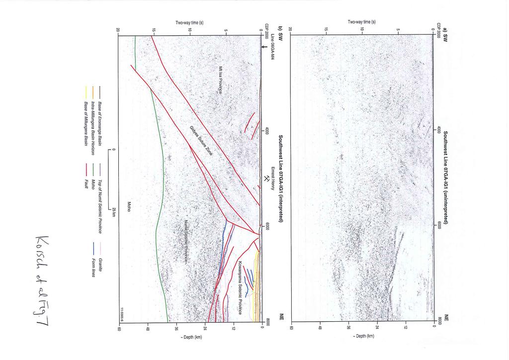
71

72
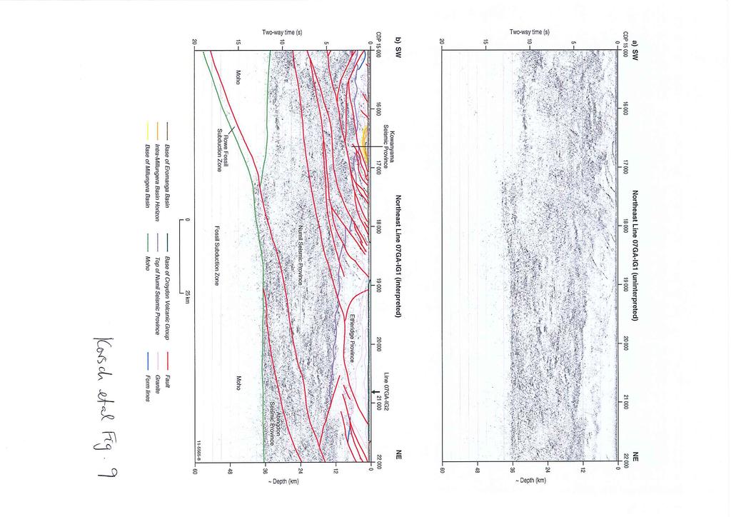
73

74

75
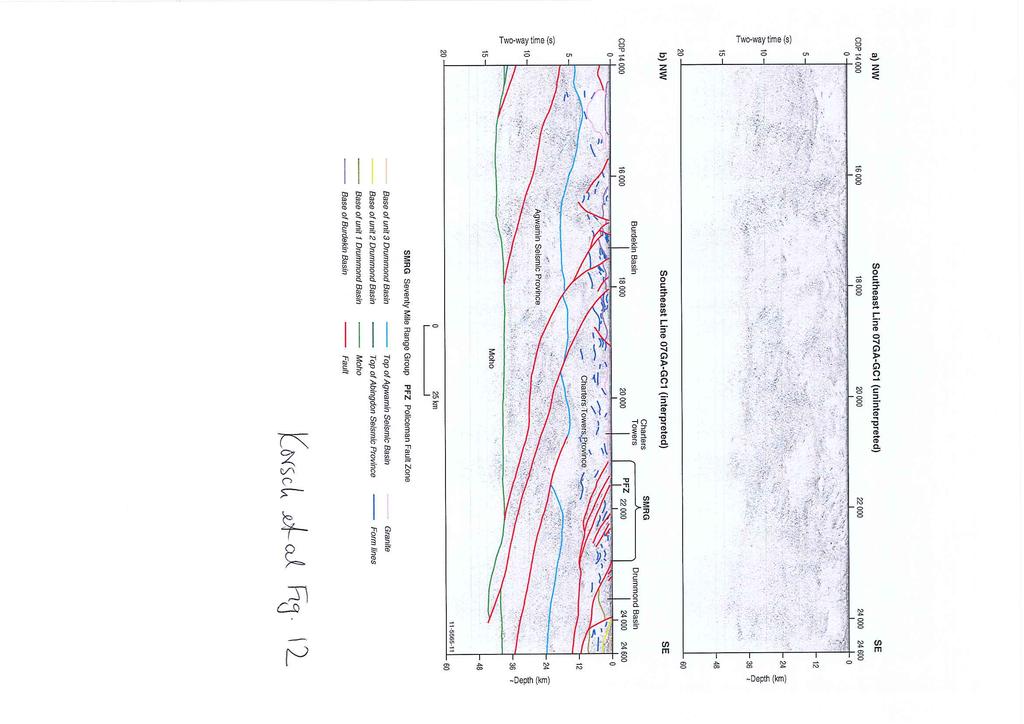
76
77

78
79

80
L.K. Carr 1, R.J. Korsch 1, A.J. Mory 2, R.M. Hocking 2, S.K. Marshall 1, R.D. Costelloe 1, J. Holzschuh 1, J.L. Maher 1. Australia.
 STRUCTURAL AND STRATIGRAPHIC ARCHITECTURE OF WESTERN AUSTRALIA S FRONTIER ONSHORE SEDIMENTARY BASINS: THE WESTERN OFFICER AND SOUTHERN CARNARVON BASINS L.K. Carr 1, R.J. Korsch 1, A.J. Mory 2, R.M. Hocking
Structural Styles and Geotectonic Elements in Northwestern Mississippi: Interpreted from Gravity, Magnetic, and Proprietary 2D Seismic Data
 Structural Styles and Geotectonic Elements in Northwestern Mississippi: Interpreted from Gravity, Magnetic, and Proprietary 2D Seismic Data Nick Loundagin 1 and Gary L. Kinsland 2 1 6573 W. Euclid Pl.,
Strike-Slip Faults. ! Fault motion is parallel to the strike of the fault.
 Strike-Slip Faults! Fault motion is parallel to the strike of the fault.! Usually vertical, no hanging-wall/footwall blocks.! Classified by the relative sense of motion. " Right lateral opposite block
5. Gravity. 5.1 Geoid Variations. The Australian Continent: A Geophysical Synthesis Gravity
 34 The Australian Continent: A Geophysical Synthesis Gravity 5. Gravity Gravity data map subtle changes in the Earth s gravitational field caused by variations in the density of the underlying materials.
3D Map and Supporting Geophysical Studies in the North Queensland Region
 G E O S C I E N C E A U S T R A L I A 3D Map and Supporting Geophysical Studies in the North Queensland Region Richard Chopping and Paul A. Henson (Editors) Record 2009/29 GeoCat # 69581 A P P LY I N G
Geological interpretation of seismic. Arrowie Basin, South Australia
 Geological interpretation of seismic reflection lines 08GA-A1 and 09TE-01: Arrowie Basin, South Australia L.K. Carr 1, R.J. Korsch 1, J. Holzschuh 1, Geological R.D. interpretation Costelloe 1, A.J. Meixner
Geodynamic implications of the GOMA deep seismic reflection line (08GA-OM1)
") Geodynamic implications of the GOMA deep seismic reflection line (08GA-OM1) Russell Korsch 1, N. Kositcin 1, R. Blewett 1, G. Fraser 1, G. Baines 2, B. Kennett 3, N. Neumann 1, A. Reid 4, W. Preiss 4,
Geodynamic implications of the GOMA deep seismic reflection line (08GA-OM1) Russell Korsch 1, N. Kositcin 1, R. Blewett 1, G. Fraser 1, G. Baines 2, B. Kennett 3, N. Neumann 1, A. Reid 4, W. Preiss 4,
L.K. Carr 1, R.J. Korsch 1, A.J. Mory 2, R.M. Hocking 2, S.K. Marshall 1, R.D. Costelloe 1, J. Holzschuh 1, J.L. Maher 1
 STRUCTURAL AND STRATIGRAPHIC ARCHITECTURE OF WESTERN AUSTRALIA S FRONTIER ONSHORE SEDIMENTARY BASINS: THE WESTERN OFFICER AND SOUTHERN CARNARVON BASINS L.K. Carr 1, R.J. Korsch 1, A.J. Mory 2, R.M. Hocking
Structural Geology of the Mountains
 Structural Geology of the Mountains Clinton R. Tippett Shell Canada Limited, Calgary, Alberta clinton.tippett@shell.ca INTRODUCTION The Southern Rocky Mountains of Canada (Figure 1) are made up of several
Preliminary results from the Thomson-Lachlan Deep Seismic Survey, northwest New South Wales
 Preliminary results from the Thomson-Lachlan Deep Seismic Survey, northwest New South Wales R.A. Glen 1, R.J. Korsch 2, R.D. Costelloe 2, Y. Poudjom Djomani 1 & R. Mantaring 1 1 New South Wales Department
This file is part of the following reference: Access to this file is available from:
 ResearchOnline@JCU This file is part of the following reference: Quentin de Gromard, R. (2011) The Paleozoic tectonometamorphic evolution of the Charters Towers Province, North Queensland, Australia. PhD
Chapter 2. Tectonic Setting of Australia. 2.1 Archaean Cratons
 Chapter 2 Tectonic Setting of Australia The Australian continent comprises a number of different tectonic blocks: Archaean and Proterozoic blocks in the western and central parts and relatively younger
Geology of the Batemans Bay region. Geological evolution. The Lachlan Orogen
 Australian Journal of Earth Sciences 1 The word orogen is derived from the ancient Greek language word for mountain building. The Lachlan Orogen The rocks exposed in the Batemans Bay are part of the geological
Answers: Internal Processes and Structures (Isostasy)
") Answers: Internal Processes and Structures (Isostasy) 1. Analyse the adjustment of the crust to changes in loads associated with volcanism, mountain building, erosion, and glaciation by using the concept
Answers: Internal Processes and Structures (Isostasy) 1. Analyse the adjustment of the crust to changes in loads associated with volcanism, mountain building, erosion, and glaciation by using the concept
Energy potential of the Millungera Basin: a newly discovered basin in North Queensland
 Energy potential of the Millungera Basin: a newly discovered basin in North Queensland Russell Korsch 1, H. Struckmeyer 1, A. Kirkby 1, L Hutton 2, L Carr 1, K. Hoffmann 2, R. Chopping 1, I. Roy 1, M.
Global Tectonics. Kearey, Philip. Table of Contents ISBN-13: Historical perspective. 2. The interior of the Earth.
 Global Tectonics Kearey, Philip ISBN-13: 9781405107778 Table of Contents Preface. Acknowledgments. 1. Historical perspective. 1.1 Continental drift. 1.2 Sea floor spreading and the birth of plate tectonics.
The Lithosphere and the Tectonic System. The Structure of the Earth. Temperature 3000º ºC. Mantle
 The Lithosphere and the Tectonic System Objectives: Understand the structure of the planet Earth Review the geologic timescale as a point of reference for the history of the Earth Examine the major relief
ENERGY POTENTIAL OF THE MILLUNGERA BASIN: A NEWLY DISCOVERED BASIN IN NORTH QUEENSLAND
 Lead author Russell Korsch ENERGY POTENTIAL OF THE MILLUNGERA BASIN: A NEWLY DISCOVERED BASIN IN NORTH QUEENSLAND R.J. Korsch 1, H.I.M. Struckmeyer 2, A. Kirkby 1, L.J. Hutton 3, L.K. Carr 1, K.L. Hoffmann
Structural Style in the Peel Region, NWT and Yukon
 Structural Style in the Peel Region, NWT and Yukon Adriana Taborda* Husky Energy and University of Calgary, Calgary, AB Adriana.Taborda@huskyenergy.ca and Deborah Spratt University of Calgary, Calgary,
Earth Science, (Tarbuck/Lutgens) Chapter 10: Mountain Building
 Chapter 10: Mountain Building") Earth Science, (Tarbuck/Lutgens) Chapter 10: Mountain Building 1) A(n) fault has little or no vertical movements of the two blocks. A) stick slip B) oblique slip C) strike slip D) dip slip 2) In a(n) fault,
Earth Science, (Tarbuck/Lutgens) Chapter 10: Mountain Building 1) A(n) fault has little or no vertical movements of the two blocks. A) stick slip B) oblique slip C) strike slip D) dip slip 2) In a(n) fault,
3. Radiometry. The Australian Continent: A Geophysical Synthesis Radiometry
 16 3. Radiometry A major effort has been made to assemble a continent-scale study combining the results of many different airborne radiometric surveys (Figure 3.1). The radiometric surveys measure the
Name. GEOL.5220 Structural Geology Faults, Folds, Outcrop Patterns and Geologic Maps. I. Properties of Earth Materials
 I. Properties of Earth Materials GEOL.5220 Structural Geology Faults, Folds, Outcrop Patterns and Geologic Maps Name When rocks are subjected to differential stress the resulting build-up in strain can
Structural Geology Lab. The Objectives are to gain experience
 Geology 2 Structural Geology Lab The Objectives are to gain experience 1. Drawing cross sections from information given on geologic maps. 2. Recognizing folds and naming their parts on stereoscopic air
Geodynamics of congested subduction zones - implications for evolution of the Tasmanides
 Geodynamics of congested subduction zones - implications for evolution of the Tasmanides Pete Betts - School of Earth, Atmosphere, and environment, Monash University Louis Moresi Department of Earth Sciences,
Study the architecture and processes responsible for deformation of Earth s crust. Folding and Faulting
 Crustal Deformation AKA Structural geology (adapted from Brunkel, 2012) Study the architecture and processes responsible for deformation of Earth s crust. Folding and Faulting How Rocks Deform: 4 Controls
STRUCTURAL AND STRATIGRAPHIC ARCHITECTURE OF AUSTRALIA S FRONTIER ONSHORE SEDIMENTARY BASINS: THE ARCKARINGA, OFFICER, AMADEUS, AND GEORGINA BASINS
 STRUCTURAL AND STRATIGRAPHIC ARCHITECTURE OF AUSTRALIA S FRONTIER ONSHORE SEDIMENTARY BASINS: THE ARCKARINGA, OFFICER, AMADEUS, AND GEORGINA BASINS L.K. Carr 1, R.J. Korsch 1, W.V. Preiss 2, S. A. Menpes
9. Density Structure. The Australian Continent: A Geophysical Synthesis Density Structure
 84 The Australian Continent: A Geophysical Synthesis Density Structure 9. Density Structure Although the primary focus for the development of the AuSREM model was the creation of 3-D seismic wavespeed
Lecture 6 Folds, Faults and Deformation Dr. Shwan Omar
 Fold: A fold is a bend or wrinkle of rock layers or foliation; folds form as a sequence of ductile deformation. Folding is the processes by which crustal forces deform an area of crust so that layers of
Copyright McGraw-Hill Education. All rights reserved. No reproduction or distribution without the prior written consent of McGraw-Hill Education
 Copyright McGraw-Hill Education. All rights reserved. No reproduction or distribution without the prior written consent of McGraw-Hill Education Tibetan Plateau and Himalaya -southern Asia 11.00.a VE 10X
KEY CHAPTER 12 TAKE-HOME QUIZ INTERNAL STRUCTURES AND PROCESSES Score Part B = / 55 PART B
 GEOLOGY 12 KEY CHAPTER 12 TAKE-HOME QUIZ INTERNAL STRUCTURES AND PROCESSES Score Part B = / 55 PART B CHAPTER 12 Isostacy and Structural Geology 1. Using the terms below, label the following diagrams and
GEOLOGIC MAPS PART II
 EARTH AND ENVIRONMENT THROUGH TIME LABORATORY - EES 1005 LABORATORY FIVE GEOLOGIC MAPS PART II Introduction Geologic maps of orogenic belts are much more complex than maps of the stable interior. Just
Geologic Structures. Changes in the shape and/or orientation of rocks in response to applied stress
 Geologic Structures Changes in the shape and/or orientation of rocks in response to applied stress Figure 15.19 Can be as big as a breadbox Or much bigger than a breadbox Three basic types Fractures >>>
10. Paleomagnetism and Polar Wandering Curves.
 Map of ocean floor Evidence in Support of the Theory of Plate Tectonics 10. Paleomagnetism and Polar Wandering Curves. The Earth's magnetic field behaves as if there were a bar magnet in the center of
CHAPTER 8. TUVA AND WEST-SAYAN
 169 CHAPTER 1. THEORY OF FAULTING AND EVALUATION OF TIMING OF FAULT MOVEMENTS: METHODOLOGY CHAPTER 2. NEOTECTONICS OF ALTAI-SAYAN CHAPTER 3. GEOLOGICAL AND GEODYNAMICAL SETTINGS CHAPTER 4. THE TELETSK
Summary. Study Area. Data Acquisition
 Evidence for hyper-extended continental crust in the East Orphan Basin from seismic reflection data and potential field forward modelling and inversion J. Kim Welford 1, Deric Cameron 2, James Carter 2
Mineral Systems modelling in the Mount Isa Inlier, and its use in identification of permissive tracts for copper and lead/zinc mineralisation.
 Department of Natural Resources and Mines Mineral Systems modelling in the Mount Isa Inlier, and its use in identification of permissive tracts for copper and lead/zinc mineralisation. L.J.Hutton Geological
Mine Scale Constrained Geophysical Inversion; A Case Study at the Darlot-Centenary Gold Mine
 Page 1 Mine Scale Constrained Geophysical Inversion; A Case Study at the Darlot-Centenary Gold Mine Sarah Monoury, SRK Consulting, Ben Jupp, SRK Consulting and Andrew Foley, Gold Fields This article was
Section 7. Reading the Geologic History of Your Community. What Do You See? Think About It. Investigate. Learning Outcomes
 Chapter 3 Minerals, Rocks, and Structures Section 7 Reading the Geologic History of Your Community What Do You See? Learning Outcomes In this section, you will Goals Text Learning Outcomes In this section,
Evolution of Continents Chapter 20
 Evolution of Continents Chapter 20 Does not contain complete lecture notes. Mountain belts Orogenesis the processes that collectively produce a mountain belt Includes folding, thrust faulting, metamorphism,
Mountain Building. Mountain Building
 Mountain Building Mountain building has occurred during the recent geologic past American Cordillera the western margin of the Americas from Cape Horn to Alaska Includes the Andes and Rocky Mountains Alpine
predictive mineral discovery*cooperative Research Centre A legacy for mineral exploration science Mineral Systems Q1 Architecture
 Mineral Systems Q1 Architecture 1 Key Parameter Mineral System Exploration is reflected in scale-dependent translation A. Gradient in hydraulic potential B. Permeability C. Solubility sensitivity to P,
CHAPTER 4 POTENTIAL FIELD MODELLING
 CHAPTER 4 POTENTIAL FIELD MODELLING POTENTIAL FIELD MODELLING The reference dataset used for the potential field modelling is the Gravity anomaly map and Magnetic anomaly map of the Atlantic region of
Regional GIS based exploration targeting studies in data poor environments
 Regional GIS based exploration targeting studies in data poor environments A case study of gold prospectivity mapping in Nigeria Matthew Greentree, Mathieu Lacorde and Bert De Waele Acknowledgements Australian
3. The diagram below shows how scientists think some of Earth's continents were joined together in the geologic past.
 1. The map below shows the present-day locations of South America and Africa. Remains of Mesosaurus, an extinct freshwater reptile, have been found in similarly aged bedrock formed from lake sediments
Quaternary clays alluvial sands of the Shepparton Formation overlie the basement rocks.
 NAGAMBIE GOLDFIELD Regional Geological Setting The Nagambie Project is located within the Melbourne Structural Zone of Victoria. The lithologies range in age from the Upper Silurian Broadford Formation
GEOLOGY GL1 Foundation Unit
 Candidate Name Centre Number Candidate Number 2 General Certificate of Education Advanced Subsidiary/Advanced 451/01 GEOLOGY GL1 Foundation Unit P.M. THURSDAY, 10 January 2008 (1 hour) Examiner Question
Drilling program commences on Cloncurry and Mount Isa projects
 1P P May UASX/Media Announcement st 2009 Drilling program commences on Cloncurry and Mount Isa projects Key Points 1,700 metres reverse circulation drilling program over two prospects on untested geochemical,
Continental Landscapes
 Continental Landscapes Landscape influenced by tectonics, climate & differential weathering Most landforms developed within the last 2 million years System moves toward an equilibrium Continental Landscapes
Distortion Effects of Faults on Gravity Worm Strings Robin O Leary
 Distortion Effects of Faults on Gravity Worm Strings Robin O Leary Problem Can upward continued gravity anomaly worm strings be used as a tool to determine the dip direction of an offsetting structure
Tectonics is a study of the major structural features of the Earth s crust or a broad structure of a region. Tecto- means building
 TECTONICS AND TECTONIC STRUCTURES Tectonics is a study of the major structural features of the Earth s crust or a broad structure of a region. Tecto- means building The plate theory Different stages are
Chapter 15 Structures
 Chapter 15 Structures Plummer/McGeary/Carlson (c) The McGraw-Hill Companies, Inc. TECTONIC FORCES AT WORK Stress & Strain Stress Strain Compressive stress Shortening strain Tensional stress stretching
Structural Geology Lab. The Objectives are to gain experience
 Geology 2 Structural Geology Lab The Objectives are to gain experience 1. Drawing cross sections from information given on geologic maps. 2. Recognizing folds and naming their parts on stereoscopic air
GREATLAND GOLD PLC (AIM:GGP) ERNEST GILES PROJECT - EASTERN YILGARN
 ERNEST GILES PROJECT - EASTERN YILGARN") GREATLAND GOLD PLC (AIM:GGP) ERNEST GILES PROJECT - EASTERN YILGARN Ownership Greatland Pty Ltd 100% Area 1,800 square kilometres Licences E38/2204 Calanchini Granted E38/2882 Carnegie Granted E38/3183
GREATLAND GOLD PLC (AIM:GGP) ERNEST GILES PROJECT - EASTERN YILGARN Ownership Greatland Pty Ltd 100% Area 1,800 square kilometres Licences E38/2204 Calanchini Granted E38/2882 Carnegie Granted E38/3183
Isan deformation, magmatism and extensional kinematics in the Western Fold Belt of the Mount Isa Inlier
 Isan deformation, magmatism and extensional kinematics in the Western Fold Belt of the Mount Isa Inlier Rick Gordon Department of Earth Sciences University of Queensland A thesis submitted for examination
Plate Tectonics. entirely rock both and rock
 Plate Tectonics I. Tectonics A. Tectonic Forces are forces generated from within Earth causing rock to become. B. 1. The study of the origin and arrangement of Earth surface including mountain belts, continents,
Thermal Map from Assessed Proxies (TherMAP): a pilot study to estimate subsurface temperatures for the Australian continent
: a pilot study to estimate subsurface temperatures for the Australian continent") Proceedings Australian Geothermal Energy Conferences 2013 Brisbane, Australia, 14-15 November 2013 Thermal Map from Assessed Proxies (TherMAP): a pilot study to estimate subsurface temperatures for the
Proceedings Australian Geothermal Energy Conferences 2013 Brisbane, Australia, 14-15 November 2013 Thermal Map from Assessed Proxies (TherMAP): a pilot study to estimate subsurface temperatures for the
LAB 1: ORIENTATION OF LINES AND PLANES
 LAB 1: ORIENTATION OF LINES AND PLANES Read the introductory section, chapter 1, pages 1-3, of the manual by Rowland et al (2007) and make sure you understand the concepts of bearing, strike, dip, trend,
Iron oxide-copper-gold potential of the southern Arunta Region
 Iron oxide-copper-gold potential of the southern Arunta Region Iron oxide-copper-gold (IOCG) deposits are a diverse family of mineral deposits unified by a number of common geological features, including
Seismic stratigraphy, some examples from Indian Ocean, interpretation of reflection data in interactive mode
 Seismic stratigraphy, some examples from Indian Ocean, interpretation of reflection data in interactive mode K. S. Krishna National Institute of Oceanography, Dona Paula, Goa-403 004. krishna@nio.org Seismic
Wind Mountain Project Summary Memo Feeder Program
 A Manex Resource Group Company Wind Mountain Project Summary Memo Feeder Program J.A. Kizis, Jr., February 07, 2018 Assays have been received for both holes drilled at Wind Mountain during late 2017 and
EXISTING GEOLOGICAL INFORMATION
 CHAPER 3 EXISTING GEOLOGICAL INFORMATION 3-1 General Geology of the Surrounding Area (1) General geology and ore deposits in Mongolia Geographically, Mongolia is a country located between Russia to the
Essentials of Geology, 11e
 Essentials of Geology, 11e Crustal Deformation and Mountain Building Chapter 17 Instructor Jennifer Barson Spokane Falls Community College Geology 101 Stanley Hatfield Southwestern Illinois College Jennifer
Proterozoic Granites - Australia
 Jan 2007 PS-T Proterozoic Granites - Australia granites widespread (~145,000 km 2 ) Proterozoic Granites - Australia range from (late Neoarchaean-) early Palaeoproterozoic to Neoproterozoic most ca. 1950-1500
!'f \, w. Alan Stewart Colorado Exploration Company, Golden STRUCTURE OF THE FOOTHILLS AREA WEST OF DENVER, COLORADO. Introduction
 STRUCTURE OF THE FOOTHLLS AREA WEST OF DENVER, COLORADO w. Alan Stewart Colorado Exploration Company, Golden ntroduction i ; The dominant structural features west of Denver and along the mountain front
Description of faults
 GLG310 Structural Geology Description of faults Horizontal stretch Crustal thickness Regional elevation Regional character Issues Normal Thrust/reverse Strike-slip >1 1 in one direction and < 1 in
New Mexico Geological Society
 New Mexico Geological Society Downloaded from: http://nmgs.nmt.edu/publications/guidebooks/25 Structure of the Guadalupe Box area, Sandoval County, New Mexico Harvey R. DuChene, 1974, pp. 131-135 in: Ghost
How mountains are made. We will talk about valleys (erosion and weathering later)
") How mountains are made We will talk about valleys (erosion and weathering later) http://www.ilike2learn.com/ilike2learn/mountainmaps/mountainranges.html Continent-continent plate convergence Less dense,
How mountains are made We will talk about valleys (erosion and weathering later) http://www.ilike2learn.com/ilike2learn/mountainmaps/mountainranges.html Continent-continent plate convergence Less dense,
GEOPHYSICS GRAVITY DATA COVERAGE
 GEOPHYSICS DATA COVERAGE The Mudgee-Gulgong district lies within the Dubbo 1:250,000 sheet area. This area is now covered by high res_olution gravity, magnetic and radiometric data. The aeromagnetic and
Crags, Cracks, and Crumples: Crustal Deformation and Mountain Building
 Crags, Cracks, and Crumples: Crustal Deformation and Mountain Building Updated by: Rick Oches, Professor of Geology & Environmental Sciences Bentley University Waltham, Massachusetts Based on slides prepared
Chapter 16. Mountain Building. Mountain Building. Mountains and Plate Tectonics. what s the connection?
 Chapter 16 Mountains and Plate Tectonics what s the connection? Mountain Building Most crustal deformation occurs along plate margins. S.2 Active Margin Passive Margin Mountain Building Factors Affecting
Topics Laramide Orogeny: Late Cretaceous to Early Eocene Reading: GSA DNAG volume 3, Ch. 6
 Topics Laramide Orogeny: Late Cretaceous to Early Eocene Reading: GSA DNAG volume 3, Ch. 6 Late Cretaceous to early Eocene New patterns developed 5 main regions Tectonic interpretations Post-Laramide events
The countdown to drilling in the Southern Thomson Orogen
 SMEDG NOVEMBER 2016 SYDNEY The countdown to drilling in the Southern Thomson Orogen John Greenfield Director Geoscience Acquisition & Synthesis Geological Survey of New South Wales Aim: Unlock a new mineral
11.1 Rock Deformation
 Tarbuck Lutgens Mountain Building 11.1 Rock Deformation Factors Affecting Deformation Factors that influence the strength of a rock and how it will deform include temperature, confining pressure, rock
Structure and history of the Kern Canyon fault system: introduction and thesis overview
 1 Chapter 1 Structure and history of the Kern Canyon fault system: introduction and thesis overview Exposures of fault zones from the surface to deep levels afford an opportunity to study the transition
SQUARE POST PROJECT CHARTERS TOWERS NORTH QUEENSLAND AUSTRALIA
 SQUARE POST PROJECT CHARTERS TOWERS NORTH QUEENSLAND AUSTRALIA Square Post - Summary PROJECT DETAILS - SQUARE POST The Square Post exploration permit (EPM 18510) contains two styles of mineralisation:
Update on Chillagoe Mining District Research: Dec 7, 2017
 Update on Chillagoe Mining District Research: Dec 7, 2017 Peter Illig 1, Zhaoshan Chang 1 1 EGRU James Cook University, Townsville QLD 4811, Australia Introduction to Chillagoe Deposits Regional introduction
7 Sedimentation and tectonics at a mid- Ordovician to Silurian active margin
 80 Mountain Building in Scotland 7 Sedimentation and tectonics at a mid- Ordovician to Silurian active margin 7.1 Introduction In mid-ordovician to Silurian times, the Grampian mountains underwent exhumation,
Lecture # 6. Geological Structures
 1 Lecture # 6 Geological Structures ( Folds, Faults and Joints) Instructor: Dr. Attaullah Shah Department of Civil Engineering Swedish College of Engineering and Technology-Wah Cantt. 2 The wavy undulations
What Forces Drive Plate Tectonics?
 What Forces Drive Plate Tectonics? The tectonic plates are moving, but with varying rates and directions. What hypotheses have been proposed to explain the plate motion? Convection Cells in the Mantle
Before Plate Tectonics: Theory of Continental Drift
 Before Plate Tectonics: Theory of Continental Drift Predecessor to modern plate tectonics Shape and fit of the continents was the initial evidence Snider-Pelligrini (1858) Taylor (1908) Wegner (1915) Fig.
Report of Activities 2003 Published by: Manitoba Industry, Economic Development and Mines Manitoba Geological Survey, 2003.
 Report of Activities 2003 Published by: Manitoba Industry, Economic Development and Mines Manitoba Geological Survey, 2003. ERRATA: The publisher/department name in the bibliographic reference cited immediately
Non-ideal Subduction
 Subduction zone cross sections Earthquake locations : black = teleseismic est. gray = local-array est. red line = top of slab seismicity blue line = center of slab seismicity Non-ideal Subduction Oblique
History of Earth. Chapter 9: HISTORY OF EARTH. The Solar System. Early Earth: A Giant Impact! Early Earth. Formation of the Solar System
 Chapter 9: HISTORY OF EARTH The Essential Earth, 2 nd Edition Thomas H. Jordan & John Grotzinger History of Earth Earth is 4.56 Billion Years Old Earth has experienced a rich and diverse history that we
3D Geometry of the Xade Complex inferred from Gravity and Magnetic Data
 Geophysical Case Histories 3D Geometry of the Xade Complex inferred from Gravity and Magnetic Data 1. British Geological Survey, Edinburgh, United Kingdom Paper 92 Pouliquen, G. [1], Key, R. [1] ABSTRACT
Lecture Outlines PowerPoint. Chapter 10 Earth Science, 12e Tarbuck/Lutgens
 Lecture Outlines PowerPoint Chapter 10 Earth Science, 12e Tarbuck/Lutgens 2009 Pearson Prentice Hall This work is protected by United States copyright laws and is provided solely for the use of instructors
Yilgarn crust and mantle lithosphere framework: geodynamic insights and interpretations
 Australian Government Geoscience Australia Yilgarn crust and mantle lithosphere framework: geodynamic insights and interpretations Minerals Exploration Seminar Perth, 29 November 2004 Acknowledgements
OZ SEEBASE TM. Datasets. Digital Elevation Model
 Digital Elevation Model 10 Digital Elevation Models (DEM s) often show the youngest structures, and any active geological structures. They are widely used for neotectonic analysis. The composition of eroding
Predictive Mineral Discovery the Yilgarn gold story.. by Y4-A3-M9-F6 Project Members. predictive mineral discovery Cooperative Research Centre
 Predictive Mineral Discovery the Yilgarn gold story.. by Y4-A3-M9-F6 Project Members Continent Y4-A3-M9-F6 Craton Province Camp-district Deposit SESSION: YILGARN 11:20 Bruce Goleby Y4) Big system big picture:
NAME HOMEWORK ASSIGNMENT #3 MATERIAL COVERS CHAPTERS 8, 9, 10, 11
 NAME HOMEWORK ASSIGNMENT #3 MATERIAL OVERS HAPTERS 8, 9, 10, 11 Assignment is due the beginning of the class period on November 23, 2004. Answers for each chapter will be discussed in class, as Exam #3
FOOT OF THE CONTINENTAL SLOPE IN ARTICLE 76
 FOOT OF THE CONTINENTAL SLOPE IN ARTICLE 76 Vaughan Stagpoole, Institute of Geological & Nuclear Sciences, Lower Hutt, New Zealand, v.stagpoole@gns.cri.nz Ray Wood, Institute of Geological & Nuclear Sciences,
GEOLOGY - GL4 INTERPRETING THE GEOLOGICAL RECORD
 Candidate Name Centre Number 2 Candidate Number GCE A level 1214/01 GEOLOGY - GL4 INTERPRETING THE GEOLOGICAL RECORD A.M. MONDAY, 21 June 2010 2 hours Section A 1. 2. 3. 15 15 15 1214 01 01 4. 15 Section
Parts of the Sevier/ Laramide Orogeny
 Parts of the Sevier/ Laramide Orogeny AA. Accretionary Prism BB. Forearc Basin Sediment scraped off of subducting plate Sediment derived from the volcanic arc CC. Volcanic Arc Magmatic intrusion into the
Crustal Deformation Earth - Chapter Pearson Education, Inc.
 Crustal Deformation Earth - Chapter 10 Structural Geology Structural geologists study the architecture and processes responsible for deformation of Earth s crust. A working knowledge of rock structures
Geology of Quesnel and Stikine terranes and associated porphyry deposits. Jim Logan Paul Schiarizza
 Geology of Quesnel and Stikine terranes and associated porphyry deposits Jim Logan Paul Schiarizza Quesnel and Stikine terranes Major cordilleran terranes characterized by similar Late Triassic Early Jurassic
L.O: THE CRUST USE REFERENCE TABLE PAGE 10
 USE REFERENCE TABLE PAGE 10 1. The oceanic crust is thought to be composed mainly of A) granite B) sandstone C) basalt D) rhyolite 2. To get sample material from the mantle, drilling will be done through
How to Build a Mountain and other Geologic Structures. But first a short review
 How to Build a Mountain and other Geologic Structures But first a short review Where do we see deep earthquakes? What is happening there? What can happen at a plate boundary? 1. Plates can move apart
Origin and Evolution of the Ocean Floor
 Origin and Evolution of the Ocean Floor Outline Mapping the Ocean Floor Continental Margins Origin of Oceanic Lithosphere Structure of Ocean Crust Mapping the ocean floor Depth originally measured by lowering
Chapter 02 The Sea Floor
 Chapter 02 The Sea Floor Multiple Choice Questions 1. One of the following is not one of the world's major ocean basins: A. Atlantic Ocean B. Arctic Ocean C. Indian Ocean D. Antarctic Ocean E. Pacific
The 2nd South Asain Geoscience Conference and Exhibition,GEOIndia2011, 12-14th Jan,2011,Gearter Noida,New Delhi,India
 Summary Jaisalmer basin of western Rajasthan: a gravity perspective K. Arora, K. Suman, M.M. Dixit and D. Sarkar The sedimentary basins of western Rajasthan constitute a part of the shelf zone of the Indus
Earthscope in the Northern Rockies Workshop
 Earthscope in the Northern Rockies Workshop Co-conveners: David Foster - University of Florida Paul Mueller - University of Florida David Mogk - Montana State University EarthScope in the Northern Rockies