L.K. Carr 1, R.J. Korsch 1, A.J. Mory 2, R.M. Hocking 2, S.K. Marshall 1, R.D. Costelloe 1, J. Holzschuh 1, J.L. Maher 1
|
|
|
- Anissa Shepherd
- 6 years ago
- Views:
Transcription
1 STRUCTURAL AND STRATIGRAPHIC ARCHITECTURE OF WESTERN AUSTRALIA S FRONTIER ONSHORE SEDIMENTARY BASINS: THE WESTERN OFFICER AND SOUTHERN CARNARVON BASINS L.K. Carr 1, R.J. Korsch 1, A.J. Mory 2, R.M. Hocking 2, S.K. Marshall 1, R.D. Costelloe 1, J. Holzschuh 1, J.L. Maher 1 1 Geoscience Australia, GPO Box 378, Canberra, ACT 2601, Australia. 2 Geological Survey Division, Department of Mines and Petroleum, Western Australia, 100 Plain Street, East Perth, WA 6044, Australia. Commonwealth of Australia (Geoscience Australia) 2012
2 Outline Onshore Energy Security Program Seismic acquisition parameters Officer Basin seismic interpretation Southern Carnarvon Basin seismic interpretation Conclusions

3 Onshore Energy Security Program 5 year program Precompetitive geoscience data and assessments on petroleum, geothermal & uranium New deep seismic reflection data across frontier basins to document basin architecture, internal geometries


4 Seismic lines 11GA-YO1 & 11GA-SC1
5 Seismic acquisition parameters Line and source type 11GA-SC1, 3 IVI Hemi 50 vibrators Sweep frequency 6-64 Hz, Hz, 8-72 Hz Line and source type 11GA-YO1, 3 IVI Hemi 50 vibrators Sweep frequency 6 64 HZ, HZ, 8 80 HZ Source array 15 m pad-to-pad, 15 m move up Sweep length 3 x 12 s Vibration point (VP) interval 80 m Receiver group 12 geophones at 3.3 m spacing Group interval 40 m Number of recorded channels 300 Fold (nominal) 75 Record length 20 s at 2 ms
6 Seismic line 11GA-YO1 across Officer Basin


7 Officer Basin stratigraphy SIMEONOVA, A. P., and IASKY, R. P., 2005, Seismic mapping, salt deformation, and hydrocarbon potential of the central western Officer Basin, Western Australia: Western Australia Geological Survey, Report 98, 51p.


8 Officer Basin well control NE SW 1625 m 3803 m m SIMEONOVA, A. P., and IASKY, R. P., 2005, Seismic mapping, salt deformation, and hydrocarbon potential of the central western Officer Basin, Western Australia: Western Australia Geological Survey, Report 98, 51p.

9 Surface control Talbot map sheet SG 52-9


10 Seismic line 11GA-YO1 uninterpreted section VE=4x
")


11 Previous cross sections (2005) Marginal Overthrusted zone SIMEONOVA, A. P. and IASKY, R. P., 2005 Seismic mapping, salt deformation, and hydrocarbon potential of the central western Officer Basin, Western Australia: Western Australia Geological Survey, Report 98, 51p.


12 Seismic line 11GA-YO1 interpreted section Paleochannel Projected Table Hill Volcanics Mesoprot outcrop VE=4x Possible salt traps
13 Summary of Officer Basin Seismic line 11GA-YO1: Provides a section across almost the entire basin Asymmetrical basin Thickening to the east Sedimentary succession has been disrupted by salt diapirs, some of which extend to the near surface Known hydrocarbon system

14 Seismic Line 11GA-SC1 across the Southern Carnarvon
 MORY, A. J.")


15 Carnarvon Basin stratigraphy (A. Mory) MORY, A. J., and BACKHOUSE, J., 1997, Permian stratigraphy and palynology of the Carnarvon Basin, Western Australia: Western Australia Geological Survey, Report 51, 46p.


16 Basin elements Gascoyne Platform Woodleigh impact structure Merlinleigh Sub-basin Byro Sub-basin Yilgarn Craton GHORI, K. A. R., 1999, Silurian Devonian petroleum source-rock potential and thermal history, Carnarvon Basin, Western Australia: Western Australia Geological Survey, Report 72, 88p.
17 Well control Well TD Age Yaringa1 (projected) Gascoyne platform 7508 feet (2,288 m) Ordovician - Tumblagooda Sandstone Woodleigh 1982/01 (Impact structure) 207 m Silurian - Dirk Hartog Formation GSWA Ballythanna 1 - Byro Sub-basin 465 m Permian - Lyons Group Hamelin Pool 1 and 2 (projected) Gascoyne platform feet (1,558 m) feet (1,219 m) Ordovician -Tumblagooda Sandstone, Silurian - Dirk Hartog Formation

18 Surface control Yaringa map sheet SG5009


19 Surface control Byro map sheet SG5010 Hanging wall anticline

20 Seismic line 11GA-SC1 uninterpreted section


21 Line 11GA-YO1 stacking velocity


22 Seismic line 11GA-SC1 interpreted section


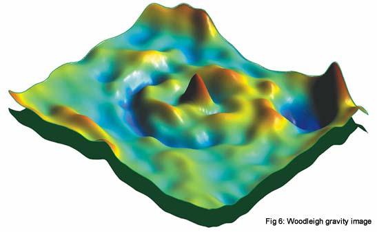
23 Woodleigh impact structure


24 Woodleigh impact structure


25 Byro Sub-basin


26 Byro Sub-basin interpretation
27 Summary of the Southern Carnarvon Basin Seismic line 11GA-SC1: Crossed the Gascoyne platform, Merlinleigh and Byro Sub-basins and part of the Yilgarn Byro Sub-basin two relatively thick half graben bounded by west-dipping faults two distinct sedimentary successions separated by an unconformity are present in both half graben Known source rocks present On the Gascoyne Platform the seismic line crosses the Woodleigh Impact Structure.
28 Conclusions Onshore Energy Security Program has collected data across several onshore frontier basins Western Officer Basin is a continuous, thickening to the east, asymmetrical depocentre, disrupted in places by salt diapirs. Southern Carnarvon Basin, showed that the Byro Sub-basin consists of two half graben, each with two distinct sedimentary rock packages Also images the Woodleigh Impact Structure in the west
L.K. Carr 1, R.J. Korsch 1, A.J. Mory 2, R.M. Hocking 2, S.K. Marshall 1, R.D. Costelloe 1, J. Holzschuh 1, J.L. Maher 1. Australia.
 STRUCTURAL AND STRATIGRAPHIC ARCHITECTURE OF WESTERN AUSTRALIA S FRONTIER ONSHORE SEDIMENTARY BASINS: THE WESTERN OFFICER AND SOUTHERN CARNARVON BASINS L.K. Carr 1, R.J. Korsch 1, A.J. Mory 2, R.M. Hocking
STRUCTURAL AND STRATIGRAPHIC ARCHITECTURE OF AUSTRALIA S FRONTIER ONSHORE SEDIMENTARY BASINS: THE ARCKARINGA, OFFICER, AMADEUS, AND GEORGINA BASINS
 STRUCTURAL AND STRATIGRAPHIC ARCHITECTURE OF AUSTRALIA S FRONTIER ONSHORE SEDIMENTARY BASINS: THE ARCKARINGA, OFFICER, AMADEUS, AND GEORGINA BASINS L.K. Carr 1, R.J. Korsch 1, W.V. Preiss 2, S. A. Menpes
Geological interpretation of seismic. Arrowie Basin, South Australia
 Geological interpretation of seismic reflection lines 08GA-A1 and 09TE-01: Arrowie Basin, South Australia L.K. Carr 1, R.J. Korsch 1, J. Holzschuh 1, Geological R.D. interpretation Costelloe 1, A.J. Meixner
Liberty Petroleum Corporation. Liberty Petroleum Corporation L-12-5 Review
 Liberty Petroleum Corporation L-12-5 Liberty Petroleum Corporation Western Australia Officer Basin Location: Officer Basin Australia Block size: 5,600,000 Acres Operator: Liberty chosen as preferred explorer,
Petroleum Potential of the Application Area L12-4
 Petroleum Potential of the Application Area L12-4 The Application Area (L12-4) is underlain by the western Officer Basin, beneath the Gunbarrel Basin. The general basin architecture is outlined in Figure
Structural and stratigraphic architecture of Australia's frontier onshore sedimentary basins: the Arckaringa, Officer, Amadeus and Georgina basins
 tructural and stratigraphic architecture of Australia's frontier onshore sedimentary basins: the Arckaringa, Officer, Amadeus and Georgina basins L Carr, R Korsch (Geoscience Australia), W Preiss, Menpes
Northern Houtman Sub-basin prospectivity preliminary results
 Northern Houtman Sub-basin prospectivity preliminary results Irina Borissova, Chris Southby, George Bernardel, Jennifer Totterdell, Robbie Morris & Ryan Owens Geoscience Australia, GPO Box 378, Canberra
Probabilistic Assessment of Geothermal Resource Bases
 Probabilistic Assessment of Geothermal Resource Bases Introduction J. Florian Wellmann 1 *, Jonathan Poh 2 and Klaus Regenauer-Lieb 1,2,+ 1 CSIRO Earth Science and Resource Engineering 2 The University
ONSHORE / OFFSHORE & NEW SHALE POTENTIAL OF MOROCCO
 Kingdom of Morocco ONSHORE / OFFSHORE & NEW SHALE POTENTIAL OF MOROCCO Mr M. NAHIM Mrs N. ESSALLOUMI Key aspects of Morocco Political and economic stability; Economic policy of integration at regional
GSWA Lower Lesueur 2D Seismic Survey. A summary on the impact of the new seismic survey on the South West Hub Carbon Capture and Storage Project
 GSWA Lower Lesueur 2D Seismic Survey A summary on the impact of the new seismic survey on the South West Hub Carbon Capture and Storage Project Cautionary Statement Advice and opinions given by Schlumberger
3. Radiometry. The Australian Continent: A Geophysical Synthesis Radiometry
 16 3. Radiometry A major effort has been made to assemble a continent-scale study combining the results of many different airborne radiometric surveys (Figure 3.1). The radiometric surveys measure the
BACK TO BASICS WHY THE TORRES BASIN COULD BE A COMPANY MAKER Papua New Guinea :PPL326 A Frontier Basin
 BACK TO BASICS WHY THE TORRES BASIN COULD BE A COMPANY MAKER Papua New Guinea :PPL326 A Frontier Basin 1 Tertiary Carbonate/Clastic Prospects and Leads PNG_LNG Facility PPL326 has a large number of over
THE HYDROCARBON POTENTIAL EXPLORATION PERMIT EP-439 ONSHORE CARNARVON BASIN WESTERN AUSTRALIA
 THE HYDROCARBON POTENTIAL OF EXPLORATION PERMIT EP-439 ONSHORE CARNARVON BASIN WESTERN AUSTRALIA by DR. B. J. WARRIS AAPG Certified Petroleum Geologist No. 4723 for ROUGH RANGE OIL PTY LTD January, 2006
Hydrocarbon Exploration in Morocco: Current Activities and Opportunities. H. Jabour
 Hydrocarbon Exploration in Morocco: Current Activities and Opportunities H. Jabour O N H Y M February 06, 2013 Outline Background Hydrocarbon potential of Morocco Non-Conventional Hydrocarbon Resources
Multicomponent seismic surveys at Sibbald Flats, Alberta
 Multicomponent seismic surveys at Sibbald Flats, Alberta Robert R. Stewart and Don C. Lawton ABSTRACT We conducted a 3C seismic survey, using vibrators, over a 5 km line in the Sibbald Flats area some
For personal use only
 19 April 2013 Company Announcements Office ASX Limited 4 th Floor 20 Bridge Street Sydney NSW 2000 CANNING BASIN SPECIAL PROSPECTING AUTHORITY AWARDED AND GAZETTAL BIDS SUBMITTED Oilex awarded a Special
Palatine Energy Pty Ltd
 Palatine Energy Pty Ltd Australian Business Number: 20 153 352 231 Geology and Resource Potential: North Perth Basin (WA STP-EPA-0127) Fig. 1 From: Western Australian Department of Mines & Petroleum letter
Preliminary results from the Thomson-Lachlan Deep Seismic Survey, northwest New South Wales
 Preliminary results from the Thomson-Lachlan Deep Seismic Survey, northwest New South Wales R.A. Glen 1, R.J. Korsch 2, R.D. Costelloe 2, Y. Poudjom Djomani 1 & R. Mantaring 1 1 New South Wales Department
The Paleozoic Hudson Bay Basin in Northern Canada: New Insights Into Hydrocarbon Potential of the Last North-America Conventional Frontier Basin*
 The Paleozoic Hudson Bay Basin in Northern Canada: New Insights Into Hydrocarbon Potential of the Last North-America Conventional Frontier Basin* Denis Lavoie 1, Nicolas Pinet 1, Jim Dietrich 2 and Zhuoheng
Hydrocarbon Exploration in Morocco: Status & Perspectives
 Hydrocarbon Exploration in Morocco: Status & Perspectives Outline Conventional HC Exploration; Licensing Status; Exploration ancient objectives and New ones Perspectives; Objectives of the Remaining open
Subsurface Geology and Resource Exploration
 LAB 11. Subsurface Geology and Resource Exploration Locating earth resources such as aluminum, copper, gold and gemstones has been an important job for geologists for a long time. This lab deals with the
Evidence Linking Surface Lineaments, Deep-Seated Faults and Fracture-Controlled Fluid Movement in the Williston Basin
 Evidence Linking Surface Lineaments, Deep-Seated Faults and Fracture-Controlled Fluid Movement in the Williston Basin Lynden Penner J.D. Mollard and Associates Limited Regina, SK Canada 14 th Williston
Petroleum geology framework, West Coast offshore region
 Petroleum geology framework, West Coast offshore region James W. Haggart* Geological Survey of Canada, Vancouver, BC jhaggart@nrcan.gc.ca James R. Dietrich Geological Survey of Canada, Calgary, AB and
SAND DISTRIBUTION AND RESERVOIR CHARACTERISTICS NORTH JAMJUREE FIELD, PATTANI BASIN, GULF OF THAILAND
 SAND DISTRIBUTION AND RESERVOIR CHARACTERISTICS NORTH JAMJUREE FIELD, PATTANI BASIN, GULF OF THAILAND Benjawan KIinkaew Petroleum Geoscience Program, Department of Geology, Faculty of Science, Chulalongkorn
Structural characteristics of northern Houtman sub-basin, Perth Basin
 Structural characteristics of northern Houtman sub-basin, Perth Basin Chris Southby* 1 Irina Borissova 1 Lisa Hall 1 Ryan Owens 1 George Bernardel 1 Emmanuelle Grosjean 1 Cameron Mitchell 1 Guillaume Sanchez
Unconformities are depositional contacts that overlie rocks distinctly older than they are. They are often called gaps in the sedimentary record.
 UNCONFORMITIES Unconformities are depositional contacts that overlie rocks distinctly older than they are. They are often called gaps in the sedimentary record. The contact represents time when no sediment
MUHAMMAD S TAMANNAI, DOUGLAS WINSTONE, IAN DEIGHTON & PETER CONN, TGS Nopec Geological Products and Services, London, United Kingdom
 Geological and Geophysical Evaluation of Offshore Morondava Frontier Basin based on Satellite Gravity, Well and regional 2D Seismic Data Interpretation MUHAMMAD S TAMANNAI, DOUGLAS WINSTONE, IAN DEIGHTON
RELINQUISHMENT REPORT. License P1546 Block April 2009
 RELINQUISHMENT REPORT License P1546 Block 110-01 14 April 2009 Sherritt International Oil and Gas Limited 2000, 425-1 st street S.W., Calgary, Alberta Canada T2P 3L8 Telephone (403) 260-2900 Fax (403)
The Pine Creek AEM Survey, Northern Territory
 The Pine Creek AEM Survey, Northern Territory (Data acquisition, processing, delivery and interpretation) M.A. Craig, M.T. Costelloe, S. Liu, S. Jaireth Onshore Energy and Minerals Division, Geoscience
Chapter 15 Structures
 Chapter 15 Structures Plummer/McGeary/Carlson (c) The McGraw-Hill Companies, Inc. TECTONIC FORCES AT WORK Stress & Strain Stress Strain Compressive stress Shortening strain Tensional stress stretching
December 21, Chapter 11 mountain building E.notebook. Feb 19 8:19 AM. Feb 19 9:28 AM
 Mountains form along convergent plate boundaries. Typically (usually) if you look at a mountain range, you know that it is at a plate boundary (active continental margin) or has been some time in the past
Karoon Awarded Exploration Permit EPP46 in Australia s Most Active Exploration Province, the Ceduna Sub Basin, Great Australian Bight
 7 October 2016 ASX Announcement Karoon Awarded Exploration Permit EPP46 in Australia s Most Active Exploration Province, the Ceduna Sub Basin, Great Australian Bight Karoon Gas Australia Ltd (ASX: KAR)
Risk Factors in Reservoir Simulation
 Risk Factors in Reservoir Simulation Dr. Helmy Sayyouh Petroleum Engineering Cairo University 12/26/2017 1 Sources Of Data Petro-physical Data Water saturation may be estimated from log analysis, capillary
REGOLITH GEOCHEMISTRY OF THE NORTH KIMBERLEY, WESTERN AUSTRALIA: A STRONG PROXY FOR BEDROCK
 REGOLITH GEOCHEMISTRY OF THE NORTH KIMBERLEY, WESTERN AUSTRALIA: A STRONG PROXY FOR BEDROCK Paul A. Morris 1 1 Geological Survey of Western Australia, 100 Plain Street, East Perth 6004, Western Australia;
Structural Geology of the Mountains
 Structural Geology of the Mountains Clinton R. Tippett Shell Canada Limited, Calgary, Alberta clinton.tippett@shell.ca INTRODUCTION The Southern Rocky Mountains of Canada (Figure 1) are made up of several
10 th Biennial International Conference & Exposition P 114. David Moore 1, Priyanka Roy Chowdhury 1, Tony Rudge 2. Summary.
 10 th Biennial International Conference & Exposition P 114 FALCON Airborne Gravity Gradiometry provides a smarter exploration tool for unconventional and conventional hydrocarbons: case study from the
Study the architecture and processes responsible for deformation of Earth s crust. Folding and Faulting
 Crustal Deformation AKA Structural geology (adapted from Brunkel, 2012) Study the architecture and processes responsible for deformation of Earth s crust. Folding and Faulting How Rocks Deform: 4 Controls
Uncovering the greater McArthur Basin, Northern Territory Tania Dhu Manager Geophysics and Remote Sensing, Northern Territory Geological Survey
 Uncovering the greater McArthur Basin, Northern Territory Tania Dhu Manager Geophysics and Remote Sensing, Northern Territory Geological Survey www.minerals.nt.gov.au Why focus on the McArthur Basin? Large,
Geology of Neoproterozoic to Cambrian Adelaide Geosyncline and Cambrian Delamerian Orogen
 Geology of Neoproterozoic to Cambrian Adelaide Geosyncline and Cambrian Delamerian Orogen W. V. Preiss Geological Survey Branch, PIRSA Link line traverses Flinders Ranges to join western end of E-W Curnamona
Crustal Deformation Earth - Chapter Pearson Education, Inc.
 Crustal Deformation Earth - Chapter 10 Structural Geology Structural geologists study the architecture and processes responsible for deformation of Earth s crust. A working knowledge of rock structures
Bulletin of Earth Sciences of Thailand. Controls on Reservoir Geometry and Distribution, Tantawan Field, Gulf of Thailand.
 Controls on Reservoir Geometry and Distribution, Tantawan Field, Gulf of Thailand Atchara Praidee Petroleum Geoscience Program, Department of Geology, Faculty of Science, Chulalongkorn University, Bangkok
Integrated well log and 3-D seismic data interpretation for the Kakinada area of KG PG offshore basin
 IOSR Journal of Applied Geology and Geophysics (IOSR-JAGG) e-issn: 2321 0990, p-issn: 2321 0982.Volume 5, Issue 4 Ver. II (Jul. Aug. 2017), PP 01-05 www.iosrjournals.org Integrated well log and 3-D seismic
Future giant discovery in the Outeniqua Basin, offshore South Africa. Anongporn Intawong & Neil Hodgson
 Future giant discovery in the Outeniqua Basin, offshore South Africa Anongporn Intawong & Neil Hodgson Spectrum Geoscience 23 February 2017 1 Talk Outlines Structural framework & Evolution of the South
EGAS. Ministry of Petroleum
 EGAS Ministry of Petroleum EGAS Ministry of Petroleum About The Block Location: N. El Arish offshore block is located in the extreme eastern part of the Egypt s economic water border and bounded from the
2.1. Central Indus Basin:
 14 2.1. Central Indus Basin: Research area lies in the Central Indus Basin of Pakistan. Central Indus Basin may be divided into following broad tectonic divisions from east to west (Kadri, 1995) (1) Punjab
The McCully gas field in southern New Brunswick was discovered in the year 2000 on a joint drilling exploration venture by Corridor Resources Inc.
 1 The McCully gas field in southern New Brunswick was discovered in the year 2000 on a joint drilling exploration venture by Corridor Resources Inc. and Potash Corporation of Saskatchewan. Located about
FUNDAMENTALS OF SEISMIC EXPLORATION FOR HYDROCARBON
 FUNDAMENTALS OF SEISMIC EXPLORATION FOR HYDROCARBON Instructor : Kumar Ramachandran 10 14 July 2017 Jakarta The course is aimed at teaching the physical concepts involved in the application of seismic
Applications of Borehole Imaging to Hydrocarbon Exploration and Production
 Applications of Borehole Imaging to Hydrocarbon Exploration and Production Instructor: Philippe MONTAGGION / NExT, Schlumberger Title: Petroleum Geology Consultant Specialty: Borehole Imaging, Petroleum
Meandering Miocene Deep Sea Channel Systems Offshore Congo, West Africa
 Meandering Miocene Deep Sea Channel Systems Offshore Congo, West Africa S. Baer* (PGS), J. E. Comstock (PGS), K. Vrålstad (PGS), R. Borsato (PGS), M. Martin (PGS), J.P. Saba (SNPC), B. Débi-Obambé (SNPC)
Blocks 31, 32, 33, 34, 35 & 36/03 Southeast Offshore Vietnam
 Blocks 31, 32, 33, 34, 35 & 36/03 Southeast Offshore Vietnam Block 31 32 33 34 35 36/03 Area (km 2) 5,036 4,440 4,630 4,700 4,630 2,950 Sea level (m) 20 20-30 30-40 50 50 50 Seismic 2D (km) 1,294 685 431
Hydrocarbon plays of the Mid North Sea High: an integrated seismic and basin modelling study
 Hydrocarbon plays of the Mid North Sea High: an integrated seismic and basin modelling study Stephen Corfield, Julian Moore, Maurice Bamford, Andrew Barnwell and Patrick Barnard -OGA Frontier exploration
Structural Style and Tectonic Evolution of the Nakhon Basin, Gulf of Thailand
 Structural Style and Tectonic Evolution of the Nakhon Basin, Gulf of Thailand Piyaphong Chenrai Petroleum Geoscience Program, Department of Geology, Faculty of Science, Chulalongkorn University, Bangkok
Play fairway mapping in the Northeast Atlantic Margin Comparison between mature and immature basins. David Mudge, Joanne Cranswick
 Play fairway mapping in the Northeast Atlantic Margin Comparison between mature and immature basins David Mudge, Joanne Cranswick Contents Ternan North Sea Play fairway mapping Tertiary case study Northeast
EGAS. Ministry of Petroleum
 EGAS Ministry of Petroleum EGAS Ministry of Petroleum About The Block Location: N. Thekah offshore block is located at about 56 km to the north of the Mediterranean shore line, 85 km to the north west
A 3D seismic survey for mapping shallow targets
 A 3D seismic survey for mapping shallow targets Don C. Lawton, Robert R. Stewart, and Malcolm B. Bertram Department of Geoscience University of Calgary 2500 University Drive N.W. Calgary, Alberta T2N 1N4
P1794 Relinquishment Document Blocks 22/2d, 22/3c & 22/4c
 P1794 Relinquishment Document Blocks 22/2d, 22/3c & 22/4c 1. Licence Information Licence Number: P1794 Licence Round: 26 th Round- Awarded January 2011 Licence Type: Traditional; (Drill or Drop within
IRAQ. Target Exploration. Geodynamic Evolutions of The Sedimentary Basins of. This study is a major reference for Petroleum
 barr Target Exploration Target Exploration Geodynamic Evolutions of The Sedimentary Basins of IRAQ This study is a major reference for Petroleum Explorationists on the tectonics, stratigraphy, sedimentary
Structural Style in the Peel Region, NWT and Yukon
 Structural Style in the Peel Region, NWT and Yukon Adriana Taborda* Husky Energy and University of Calgary, Calgary, AB Adriana.Taborda@huskyenergy.ca and Deborah Spratt University of Calgary, Calgary,
Petroleum Prospectivity in the Namibe and Southern Benguela Basins, Offshore Angola
 Petroleum Prospectivity in the Namibe and Southern Benguela Basins, Offshore Angola C. Koch* (PGS), F. Pepe (PGS), R. Vasconcelos (PGS), F. Mathew (PGS), R. Borsato (PGS) & M.P.C. de Sá (Sonangol) SUMMARY
Name. GEOL.5220 Structural Geology Faults, Folds, Outcrop Patterns and Geologic Maps. I. Properties of Earth Materials
 I. Properties of Earth Materials GEOL.5220 Structural Geology Faults, Folds, Outcrop Patterns and Geologic Maps Name When rocks are subjected to differential stress the resulting build-up in strain can
The truth about Triassic salt tectonic models for the Northern North Sea
 The truth about Triassic salt tectonic models for the Northern North Sea Christopher A-L. Jackson Basins Research Group (BRG), Department of Earth Science & Engineering, Imperial College, Prince Consort
Blocks offered in Sri Lanka s Second Licensing Round
 Blocks offered in Sri Lanka s Second Licensing Round Sri Lankan Main Basins Cauvery Basin Cauvery Deep Water sub-basin Mannar Basin 2 Structural Framework Sri Lanka Basins Cauvery & Mannar Basins were
Key Elements of the Petroleum Systems of the Rockall and Slyne-Erris Basins
 Key Elements of the Petroleum Systems of the Rockall and Slyne-Erris Basins Bandon Corrib Dooish Atlantic Ireland Conference, Dublin, 1 st - 2 nd November 2016 Rockall and Slyne-Erris Basins Only 11 exploration
Sedimentary Cycle Best Practice: Potential Eo-Oligocene Sediments in Western Indonesia*
 Sedimentary Cycle Best Practice: Potential Eo-Oligocene Sediments in Western Indonesia* Mellinda Arisandy 1 and I Wayan Darma 1 Search and Discovery Article #11008 (2017)** Posted November 6, 2017 *Adapted
Orphan Basin, Offshore Newfoundland: New seismic data and hydrocarbon plays for a dormant Frontier Basin
 Orphan Basin, Offshore Newfoundland: New seismic data and hydrocarbon plays for a dormant Frontier Basin Jerry Smee* G&G Exploration Consulting, 301 400-3rd Avenue SW, Calgary, AB, T2P 4H2 Sam Nader, Paul
OIL AND GAS PLAYS OF THE MICHIGAN BASIN, SOUTHERN ONTARIO. Terry Carter, Consulting Geologist London, Ontario
 OIL AND GAS PLAYS OF THE MICHIGAN BASIN, SOUTHERN ONTARIO Terry Carter, Consulting Geologist London, Ontario 1 Ontario Petroleum Industries Oil and Natural Gas 1250 oil wells, 1200 gas wells, annual production
Appendix B: Geophysical Data (Thesis Appendix, 2013)
") Utah State University From the SelectedWorks of David J Richey 2013 Appendix B: Geophysical Data (Thesis Appendix, 2013) David J Richey, Utah State University Available at: https://works.bepress.com/david_richey/2/
Utah State University From the SelectedWorks of David J Richey 2013 Appendix B: Geophysical Data (Thesis Appendix, 2013) David J Richey, Utah State University Available at: https://works.bepress.com/david_richey/2/
Earth Science, (Tarbuck/Lutgens) Chapter 10: Mountain Building
 Chapter 10: Mountain Building") Earth Science, (Tarbuck/Lutgens) Chapter 10: Mountain Building 1) A(n) fault has little or no vertical movements of the two blocks. A) stick slip B) oblique slip C) strike slip D) dip slip 2) In a(n) fault,
Earth Science, (Tarbuck/Lutgens) Chapter 10: Mountain Building 1) A(n) fault has little or no vertical movements of the two blocks. A) stick slip B) oblique slip C) strike slip D) dip slip 2) In a(n) fault,
Sequence Stratigraphy. Historical Perspective
 Sequence Stratigraphy Historical Perspective Sequence Stratigraphy Sequence Stratigraphy is the subdivision of sedimentary basin fills into genetic packages bounded by unconformities and their correlative
11.1 Rock Deformation
 Tarbuck Lutgens Mountain Building 11.1 Rock Deformation Factors Affecting Deformation Factors that influence the strength of a rock and how it will deform include temperature, confining pressure, rock
Multiattributes and Seismic Interpretation of Offshore Exploratory Block in Bahrain A Case Study
 Multiattributes and Seismic Interpretation of Offshore Exploratory Block in Bahrain A Case Study Suresh Thampi, Aqeel Ahmed, Yahya Al-Ansari, Ali Shehab, Ahmed Fateh, Anindya Ghosh, Ghada Almoulani. The
Reprocessing strategy for shallower prospects from the available 3D data set Case history of Cambay Basin
 P-378 Reprocessing strategy for shallower prospects from the available 3D data set Case history of Cambay Basin M.Singh*, Vikash Chandra, USD Pandey Summary The occurrence of non commercial hydrocarbons
Aptian/Albian Reservoir Development in the Jeanne d Arc Basin, Offshore Eastern Canada
 Aptian/Albian Reservoir Development in the Jeanne d Arc Basin, Offshore Eastern Canada Jonathan Marshall, Statoil Canada Ltd. Calgary, Alberta, Canada. jomars@statoil.com Introduction: The Jeanne d Arc
Akshaya Kumar*, Ganesh Karri, Manish Kumar Gupta, S.K.Das,V. K. Kulshrestha, Oil India Ltd.
 P-377 An Integrated Approach Using Non Seismic and Seismic Surveys for Hydrocorbon Exploration in the Interior Sub-Basin, Gabon (Central West Africa) A Case Study Akshaya Kumar*, Ganesh Karri, Manish Kumar
Seismic Reflection Results: Stewart Gulch Region, Boise, Idaho
 Seismic Reflection Results: Stewart Gulch Region, Boise, Idaho Report Prepared for The Terteling Company Boise, Idaho Lee M. Liberty Center for Geophysical Investigation of the Shallow Subsurface (CGISS)
REGIONAL GEOLOGY IN KHMER BASIN
 CONTENTS 1-Khmere Basin 2-Regional Geology Khmer Basin 3-Regime Tectonic 4-Seismic Database -a/ Acquisition Data -b/ Prospect Angkor -C/ Cross Section Seismic 5-Play Type -a/ Play Schematic -b/ Structure
Building for the Future with Global Knowledge and Dedicated Skills. Jan Maier North Africa Capital Markets Day
 Building for the Future with Global Knowledge and Dedicated Skills Jan Maier North Africa 1 Core Plays: Recent and Current Exploration in North Africa Sirte Basin Matruh Basin CORE PLAYS Fold Belts Rift
predictive mineral discovery*cooperative Research Centre A legacy for mineral exploration science Mineral Systems Q1 Architecture
 Mineral Systems Q1 Architecture 1 Key Parameter Mineral System Exploration is reflected in scale-dependent translation A. Gradient in hydraulic potential B. Permeability C. Solubility sensitivity to P,
For personal use only
 ASX ANNOUNCEMENT 11 September 2018 Billion Barrel Oil Potential Assessed in Pancontinental s PEL 87 Offshore Namibia Giant* scale oil potential in multiple Large Leads in PEL 87 Vast Cretaceous Superfan
!'f \, w. Alan Stewart Colorado Exploration Company, Golden STRUCTURE OF THE FOOTHILLS AREA WEST OF DENVER, COLORADO. Introduction
 STRUCTURE OF THE FOOTHLLS AREA WEST OF DENVER, COLORADO w. Alan Stewart Colorado Exploration Company, Golden ntroduction i ; The dominant structural features west of Denver and along the mountain front
GEOLOGIC MAPS PART II
 EARTH AND ENVIRONMENT THROUGH TIME LABORATORY - EES 1005 LABORATORY FIVE GEOLOGIC MAPS PART II Introduction Geologic maps of orogenic belts are much more complex than maps of the stable interior. Just
For personal use only
 14 View Street North Perth, Western Australia, 6006 PO Box 317 North Perth, Western Australia 6906 Telephone + 61 (08) 9328 8400 Facsimile + 61 (08) 9328 8733 Email admin@grandbridge.com.au Internet www.grandbridge.com.au
Beneath the sand of the Tanami Desert
 Beneath the sand of the Tanami Desert ARGA 2018, Wallaroo, SA Nadir de Souza Kovacs Ngururrpa program The program area covers the traditional land of the Parna Ngururrpa People in a remote part of the
Lecture Outlines PowerPoint. Chapter 10 Earth Science, 12e Tarbuck/Lutgens
 Lecture Outlines PowerPoint Chapter 10 Earth Science, 12e Tarbuck/Lutgens 2009 Pearson Prentice Hall This work is protected by United States copyright laws and is provided solely for the use of instructors
Chapter 16. Mountain Building. Mountain Building. Mountains and Plate Tectonics. what s the connection?
 Chapter 16 Mountains and Plate Tectonics what s the connection? Mountain Building Most crustal deformation occurs along plate margins. S.2 Active Margin Passive Margin Mountain Building Factors Affecting
For personal use only
 12 October 2012 Companies Announcement Office Australian Securities Exchange Limited 10th Floor, 20 Bond Street SYDNEY NSW 2000 ADVENT ENERGY LTD SHALE GAS DATA RELEASE MEC Resources Limited (ASX:MMR)
What Causes Rock to Deform?
 Crustal Deformation Earth, Chapter 10 Chapter 10 Crustal Deformation What Causes Rock to Deform? Deformation is a general term that refers to all changes in the shape or position of a rock body in response
2D Seismic Interpretation and Well Log Analysis of Missakaswal Area, Upper Indus Basin, Pakistan
 2D Seismic Interpretation and Well Log Analysis of Missakaswal Area, Upper Indus Basin, Pakistan Urooj Shakir 1, Muyyassar Hussain 2, Rida Azhar 1, Anum Zafar 1, Snodia Asghar 1, Muhammad Raiees Amjad
Ireland Atlantic Margin: a new era in a frontier basin
 first break volume 32, December 2014 special topic Ireland Atlantic Margin: a new era in a frontier basin Richard Wrigley 1, Anongporn Intawong 1 and Karyna Rodriguez 1* review the prospectivity of the
GEOLOGY - GL4 INTERPRETING THE GEOLOGICAL RECORD
 Candidate Name Centre Number 2 Candidate Number GCE A level 1214/01 GEOLOGY - GL4 INTERPRETING THE GEOLOGICAL RECORD A.M. MONDAY, 21 June 2010 2 hours Section A 1. 2. 3. 15 15 15 1214 01 01 4. 15 Section
Outcrops from Every Continent and 20 Countries in 140 Contributions. Tor H. Nilsen, Roger D. Shew, Gary S. Steffens, and Joseph R.J. Studlick.
 Paper VIII Tor H. Nilsen, Roger D. Shew, Gary S. Steffens, and Joseph R.J. Studlick Editors Outcrops from Every Continent and 20 Countries in 140 Contributions http://bookstore.aapg.org Length ~ 23 m (75.5
FALCON AGG inversion to constrain 3D geological models in the Glyde Sub-Basin, Northern Territory
 FALCON AGG inversion to constrain 3D geological models in the Glyde Sub-Basin, Northern Territory Peter Kovac 1, Luke Titus 2, Carlos Cevallos 3, Josh Bluett 2, Fabio Vergara 3 1 CGG GravMag Solutions,
: Morondava Basin, Offshore Madagascar New Long Offset Seismic Data highlights the Petroleum Prospectivity of this Emerging Frontier Basin.
 1555684: Morondava Basin, Offshore Madagascar New Long Offset Seismic Data highlights the Petroleum Prospectivity of this Emerging Frontier Basin. Glyn Roberts(1); Trond Christoffersen(2); Huang Weining(3).
A comparison of structural styles and prospectivity along the Atlantic margin from Senegal to Benin. Peter Conn*, Ian Deighton* & Dario Chisari*
 A comparison of structural styles and prospectivity along the Atlantic margin from Senegal to Benin Overview Peter Conn*, Ian Deighton* & Dario Chisari* * TGS, Millbank House, Surbiton, UK, KT6 6AP The
Deepwater Niger Delta fold-and-thrust belt modeled as a critical-taper wedge: The influence of a weak detachment on styles of fault-related folds
 Deepwater Niger Delta fold-and-thrust belt modeled as a critical-taper wedge: The influence of a weak detachment on styles of fault-related folds Frank Bilotti 1, Chris Guzofski 1, John H. Shaw 2 1 Chevron
Devonian Petroleum Systems and Exploration Potential, Southern Alberta, Part 3 Core Conference
 Devonian Petroleum Systems and Exploration Potential, Southern Alberta, Part 3 Core Conference Andy Mort (1), Leonard Stevens (2), Richard Wierzbicki (2) Abstract Part 1: Devonian Petroleum Systems Dr.
Figure 1: Location and bathymetry of the study area. Gulf of Guinea. Cameroon. Congo. Gabon. PGS/DGH Gabon MegaSurvey Coverage (35000Km 2 ) Eq.
 Eq.") Deepwater hydrocarbon prospectivity analysis of offshore North and South Gabon Muhammad S Tamannai (*), Thomas Hansen (1), Ron Borsato (1), Jennifer Greenhalgh (1) Martial-Rufin Moussavou (2) & Landry
Deepwater hydrocarbon prospectivity analysis of offshore North and South Gabon Muhammad S Tamannai (*), Thomas Hansen (1), Ron Borsato (1), Jennifer Greenhalgh (1) Martial-Rufin Moussavou (2) & Landry
Airborne gravity gradiometer surveying of petroleum systems under Lake Tanganyika, Tanzania
 Airborne gravity gradiometer surveying of petroleum systems under Lake Tanganyika, Tanzania D. Roberts Beach Energy P. Roy Chowdhury CGG S. J. Lowe CGG A. N. Christensen CGG Outline Introduction Geology
MkII Airborne Laser Fluorosensor Survey Reprocessing And Interpretation Report: Barrow Sub-basin, Carnarvon Basin, North West Shelf, Australia
 MkII Airborne Laser Fluorosensor Survey Reprocessing And Interpretation Report: Barrow Sub-basin, Carnarvon Basin, North West Shelf, Australia Prepared For AGSO Geoscience Australia June 2001 Record 2001/20
Relinquishment Report
 Relinquishment Report Licence P1403 Block 13/22d Chevron North Sea Limited Korean National Oil Company Chevron North Sea Limited December 2009 1 SYNOPSIS... 3 2 INTRODUCTION. 3 2.1 Licence Terms.. 3 2.2