THE HYDROCARBON POTENTIAL EXPLORATION PERMIT EP-439 ONSHORE CARNARVON BASIN WESTERN AUSTRALIA
|
|
|
- Marjory Garrett
- 6 years ago
- Views:
Transcription
1 THE HYDROCARBON POTENTIAL OF EXPLORATION PERMIT EP-439 ONSHORE CARNARVON BASIN WESTERN AUSTRALIA by DR. B. J. WARRIS AAPG Certified Petroleum Geologist No for ROUGH RANGE OIL PTY LTD January, 2006
2 TABLE OF CONTENTS LIST OF ILLUSTRATIONS...2 EXECUTIVE SUMMARY INTRODUCTION PERMIT DETAILS EXPLORATION HISTORY REGIONAL GEOLOGY AND STRATIGRAPHY HYDROCARBON POTENTIAL Reservoir/Seal Point Maud Member Gneudna Formation Nannyarra Sandstone Source Maturity Timing SEISMIC INTERPRETATION LAKE MACLEOD PROSPECT REFERENCES...11 LIST OF ILLUSTRATIONS FIGURES Figure 1 Figure 2 Figure 3 Figure 4 Figure 5 Figure 6 Figure 7 Locality Map and Tectonic Elements Generalised Stratigraphy Frasnian Palaeogeography Gneudna Formation Source Rocks Maturity Map Gneudna Formation Time Structure Map Top Dirk Hartog Group Seismic Line CG83-01L ENCLOSURES Enclosure 1 Stratigraphic Correlation
3 EXECUTIVE SUMMARY Exploration Permit EP-439 is located in the Gascoyne Sub-basin and covers an area of 7,200 sq kms (1.8 million acres). The Northwest Coastal Highway, an all weather sealed road, runs northsouth through the western part of the permit, and the Dampier-Perth Natural Gas Pipeline transverses north-south through the eastern part of the permit. The port of Carnarvon is only 30 kilometres to the south of the permit. The Gascoyne Sub-basin contains up to 6,000 metres of Late Cambrian, Ordovician, Silurian, Devonian, Carboniferous, and Permian marine clastic and carbonate sediments. The main play in EP-439 is the Late Devonian reefs, dolomites and carbonates of the Gneudna Formation, sealed and sourced by the intra-formational marine shales. Carbonate and dolomite reservoirs within the Gneudna Formation have been demonstrated to have reservoir potential in the Gascoyne Sub-basin. Barrabiddy-1A intersected a dolomitised reef with Amphipora stromotoporoids and rugose corals in the Gneudna Formation. One core sample near the top of the reef had porosity of 15.5% with an effective permeability of 40.7 millidarcies. However, complete loss circulation during the drilling of the reef section attest to much higher permeabilities. At Quobba-1, secondary porosity in a dolomite at 1,170 metres had log-derived values of up to 15%. This dolomite was open hole drill stem tested and flowed some 1,000 BWPD from about 5 metres of porosity. Permeabilities from this test were good. Good oil-prone Type II source rocks are present in organic-rich marine shales of the Late Devonian Gneudna Formation. TOC s range from % with common to abundant sapropel and alginite. Rock-Eval S1+ S2 range up to 40 mg/gm with hydrogen indicies varying from indicating Type II source rocks. These source rocks are in the oil generation window over the northern half of EP-439. The main structures in EP-439 formed either during the Early Devonian Pertnjara Movement or during the Miocene. The Miocene structures (Quobba-1, Pendock-1D and Wandagee-1) all postdate primary hydrocarbon migration and are dry. The Early Devonian structures, however, pre-date primary hydrocarbon migration from the Gneudna Formation source rocks which generated their hydrocarbons during the Late Carboniferous to Permian. None of these aged structures have been drilled in the Gascoyne Sub-basin. In Exploration Permit EP-439, the main prospect is the Lake Macleod Prospect. Quobba-1 was drilled on a Miocene compressional anticline with the underlying Devonian sediments dipping to the west. A large structure is present to the east. The Devonian sediments drape over an older Silurian fault block and therefore the Lake Macleod structure has been present since Late Devonian times. Timing of oil migration from the Gneudna Formation source rocks into the Lake Macleod Prospect is excellent. The Lake Macleod Prospect covers an area of 27,500 hectares (70,000 acres) with a vertical relief of 100 milliseconds (150 metres). Estimated potential recoverable reserves for the Lake Macleod prospect are of the order of 150 million barrels. It is planned to drill the Lake Macleod Prospect during the second half of Farmout terms are for farmines to contribute 100% of the well cost (estimated to be $1.5 million) to earn 75% interest in the entire permit.
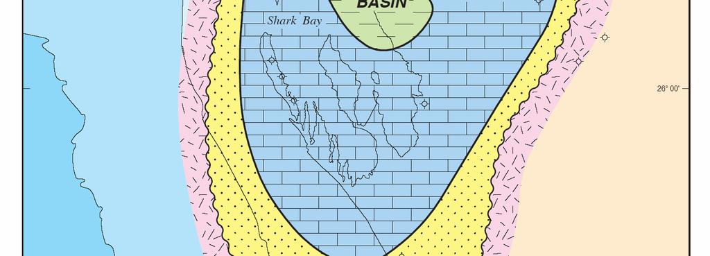
4 1 INTRODUCTION Exploration Permit EP-439 is located in the Gascoyne Sub-basin and covers an area of 7,200 sq kms (1.8 million acres). The Northwest Coastal Highway, an all weather sealed road, runs northsouth through the western part of the permit, and the Dampier-Perth Natural Gas Pipeline transverses north-south through the eastern part of the permit. The port of Carnarvon is only 30 kilometres to the south of the permit (Figure 1). 2 PERMIT DETAILS The permit was awarded on the 2 nd February, 2006 for an initial six year period. The permit consists of 95 graticular blocks covering an area of 7,200 square kilometres (1.8 million acres). Permit holders are summarised below: Permit Holder Rough Range Oil Pty Ltd 44.44% Euro Pacific Energy Pty Ltd 31.67% Indigo Oil Pty Ltd 11.11% Falcore Pty Ltd 11.11% Vigilant Oil Pty Ltd 1.67% The work obligations for the permit are summarised below: Permit Year Period Minimum Work Requirements Estimated Expenditure One 2/2/05 1/2/06 Seismic Reprocessing $100,000 Two 2/2/06 1/2/07 Seismic Interpretation $100,000 Three 2/2/07 1/2/ kms 2D Seismic Survey $1,200,000 Four 2/2/08 1/2/ kms 2D Seismic Survey $600,000 Five 2/2/09 1/2/10 Seismic Processing & Interpretation $150,000 Six 2/2/10 1/2/11 One (1) Exploration Well $600,000 Total $2,750,000 The Year One seismic reprocessing has been completed and the permit is in good standing.
5 3 EXPLORATION HISTORY Only two wells have been drilled in the permit. These are a stratigraphic well Cape Cuvier-1 and Quobba-1 by Canada Northwest in At the end of 1990, Western Geophysical Australia conducted a speculative vibroseis survey in the area between Wandagee-1 in the east and Lake Macleod in the west. This program comprised 312 kilometres of regional coverage and incorporating the reprocessed Wapet line 72-2, a long eastwest regional line in EP-439. The Geological Survey of Western Australia, in an attempt to upgrade the petroleum industry s perception of the hydrocarbon potention of the Palaeozoic sequences onshore Carnarvon Basin, drilled two stratigraphic wells, Gneudna-1 in 1995 and Barrabiddy-1A in The results of these wells have been described by Mory (1996) and Mory & Yasin (1997). Exploration permit EP-439 was awarded to the current joint venture in The Operator has reinterpreted the existing seismic data and incorporated the drilling results of the Geological Survey of Western Australia stratigraphic wells, Gneudna-1 and Barrabiddy-1A into a full evaluation of the permit. This report summarises the results of this evaluation. 4 REGIONAL GEOLOGY AND STRATIGRAPHY The Gascoyne Sub-basin contains a sequence of up to 6,000 metres of Cambrian to Lower Carboniferous sediments deposted between the Pilbara Block to the east, the Bernier Platform to the west, the Northampton Block to the south and which opens to the north where it plunges beneath the thick Mesozoic to Tertiary Exmouth Sub-basin (Figure 1). The generalised stratigraphy of the Gascoyne Sub-basin is illustrated in Figure 2. This is based on formations outlined by Hocking et al (1987) and modified by Gorter et al (1994). Sedimentation began in the Gascoyne Sub-basin during the Late Cambrian with tectonic activity and uplift of the Pilbara and Northampton blocks. This provided clastic sedimentation (Tumblagooda Sandstone) in the form of thick fluvial, alluvial and fan deposition which grade northwards into marginal marine to tidal deposits. These sediments were deposited in a transgressive system tract during progressive rising sea levels with transgression to the south (Gorter et al, 1994). After a period of non-deposition during most of the Ordovician, a marine transgression began in the Late Ordovician allowing carbonate and evaporitic sedimentation (Dirk Hartog Group) to occur on a shallow, warm and partly restricted shelf. These sediments were deposited in alternating transgressive and high stand system tracts with a low stand (Yaringa Evaporite) during the Homerian (Gorter et al, 1994). These conditions continued throughout the Silurian and were terminated by uplift and erosion with marginal marine and tidal clastic deposits of the Kopke Sandstone prograding across the shelf as a high stand system tract. Shallow, warm carbonate and evaporitic conditions (Sweeny Mia Formation) were again established over the area during the Early Devonian during a transgressive
6 and then high stand system tracts (Gorter et al, 1994). This phase of sedimentation was terminated by the Pertnjara Orogeny. During the Givetian, a marine clastic shelf was established over the basin. Shallow marine sandstones (Nannyarra Sandstone) were deposited in beach, barrier island and tidal channel complexes with deeper water shoreface environments occuring in the central parts of the basin. The basin was closed to the south and opened out to the north where it was connected to the Canning and Bonaparte basins (Warris, 1993). Rising sea levels during the late Givetian, Frasnian and early Famennian established a carbonate shelf Gneudna Formation) over the basin. Environments consisted of mud flats, lagoons, shallow shelf with Amphipora stromatoporoid reefs (Point Maud Member of Geary, 1970) and oolite banks. The shelf edge is interpreted to be to the north under the Exmouth Sub-basin but with a tongue of deep water interpreted to extend along the axis of the Gascoyne Sub-basin at least as far south as Quobba-1 (Figure 3). The Gneudna Formation is thick (at least 1000 metres) and comprises alternating transgressive and high stand system tracts. (Gorter et al, 1998). During the Famennian, uplift of the Pilbara Block allowed the alluvial fan deposition of the Willaraddie Formation (Moors, 1981) along the eastern flanks of the Merlinleigh and Ashburton Sub-basins. To the west, these are believed to grade into the extensive marine clastics of the Munabia Sandstone (Nicoll, 1979 and Warris, 1993 & 1994). By Tournaisian times, the basin deepened and quiet conditions prevailed and a broad carbonate shelf (Moogooree Limestone) was established over the basin (Hocking et al, 1987 and Baillie & Jacobsen, 1995). Tectonic activity and uplift of the Pilbara Block at the end of the Tournaisian allowed alluvial fan deposition (Williambury Formation) along the eastern flanks of the Merlinleigh and Ashburton Sub-basins (Hocking et al, 1987). To the west, these are believed to grade into marine clastics which were followed by Visean carbonate deposition (Yindagindy Formation) and Namurian clastic deposition (Quail Formation) (Nicoll & Gorter, 1994). This sequence was terminated during the Mid-Carboniferous by the Alice Springs Orogeny. The major Giralia and Wandagee faults are believed to have formed at this time burying the Merlinleigh, Ashburton and northern Gascoyne sub-basins under considerable thicknesses of Permian sediments. The Gascoyne Sub-basin was uplifted metres relative to the Merlinleigh Sub-basin (Blake et al, 1984) and became a major Permian depocentre. It is not known if Triassic or Jurassic sediments were deposited in the Gascoyne Sub-basin. If they were, they, together with the Permian sediments, were eroded during major periods of uplift and block faulting during the Late Triassic, Late Jurassic and Early Cretaceous. A major marine transgression began in the late Valanginian and flooded the basin with uniform marine clastics. With the decline in the influx of terrigenous sediment as Australia moved northward into more tropical latitudes, shelf carbonates became established during the Turonian to Santonian. The Tertiary was mostly a period of erosion with nearshore marine carbonate and clastic deposition during the Eocene. Mid-Miocene compression and wrenching, caused by Australia colliding with the Asian plate, formed a number of reverse faulted anticlines (Baillie & Jacobsen, 1995) some of which are related to older Palaeozoic faults. These anticlines persist only down to the Base Cretaceous Unconformity below which the Palaeozoic structures are quite different (Warris, 1993).
7 5 HYDROCARBON POTENTIAL 5.1 Reservoir/Seal Point Maud Member One of the main objectives in EP-439 is the Frasnian reefal Point Maud Member of the Gneudna Formation. Point Maud reefs have only been encountered in two wells in the Gascoyne Sub-basin; Pendock-1D and Barrabiddy-1A. In Pendock-1D, the Point Maud Member is composed of massive, fine to coarse grained dolomite containing abundant Amphipora stromatoporoids and rare rugose corals (Geary, 1970). It has sonic log-derived porosities of up to 10%. In Barrabiddy-1A, the Point Maud Member consist of dolomitised limestones with Amphipora stromotoporoid floatstones, rugose coral packstones and boundstones, bryozoan-brachiopod-crinoid packstones, and brachiopod-crinoid grainstones. The section was continuously cored and had intercrystalline and leached vuggy and cavernous porosities, and was brecciated and fractured. Most of the core broke up and was unsuitable for core analysis. One sample at 283 metres near the top of the reef had porosity of 15.5% with an effective permeability of 40.7 millidarcies. However, complete loss circulation during the drilling of the reef section (Mory & Yasin, 1998) attest to much higher permeabilities. In Barrabiddy-1A, the Point Maud Member reef was unconformably overlain by the Munabia Sandstone and therefore is not sealed. The Point Maud Member reef in Pendock-1D, was conformably overlain by 200 metres of interbedded marls and calcilutites of the upper Gneudna Formation which provides an excellent seal. However, it is believed that the Devonian section in Pendock-1D had been deeply buried, diagenetically altered and then uplifted prior to Cretaceous sedimentation. In addition, Pendock-1D was drilled on a Cretaceous anticline with the underlying Devonian section dipping at 20º to the west (Figure 6, Geary, 1970). It was not a valid test of the Point Maud Member reef. In EP-410, seal is inferred to be provided by thick marine shales and marls of the upper Gneudna Formation overlying the Point Maud Member (Enclosure 1) Gneudna Formation Carbonate reservoirs within the Gneudna Formation have been demonstrated to have reservoir potential and are the main objectives for the Lake Macleod Prospect in EP-439. At Quobba-1, secondary porosity in a dolomite at 1,170 metres had log-derived values of up to 15% (Blake et al, 1984). This dolomite was open hole drill stem tested and flowed some 1,000 BWPD from about 5 metres of porosity. Permeabilities from this test were good. Loss circulation in carbonates was also encountered in Quobba-1 between metres. Seal is provided by intra-formational marine shales and marls within the Gneudna Formation (Enclosure 1).
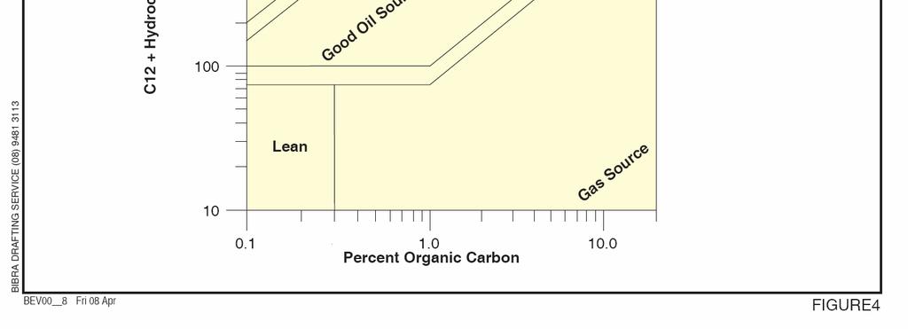
8 5.1.3 Nannyarra Sandstone The Nannyarra Sandstone also provides a secondary objective in EP-439. These sandstones have log-derived porosities of 15-20% with good permeabilities in Wandagee-1; log-derived porosities of up to 30% in Echo Bluff-1 (Warris, 1993); and core-derived porosities of up to 18.3% with permeabilities of 28 millidarcies in Pendock-1D. Vertical seal is provided by the regional marine shales of Sequence 1 at the base of the Gneudna Formation (Gorter et al, 1998). This shale unit is of the order of 100 metres thick in Pendock-1D, Quail-1 and Quobba-1 (Enclosure 1), and would also provide lateral seal across small faults. 5.2 Source According to Klemme & Ulmishek (1991), 8% of the world s oil was generated from platform or intracratonic sag black shale facies of Frasnian to Tournaisian age. Eighty percent of these reserves are oil and were sourced from mostly Type 1 kerogens deposited within 45º of the equator. Palaeogeographical reconstructions show that the Gascoyne Sub-basin lay between 25º to 30º south of the equator during the Upper Devonian (Figure 3 of Ormiston & Oglesby, 1995). Good oil-prone source rocks are present in organic-rich marine shales in the lower part of the Gneudna Formation. This is based on source rock analyses by AGSO (Edwards et al, 1997); Industry (Analabs, 1984 & 1985; Percival & Cooney, 1985; Purcell & Ingram, 1984; and Blake et al, 1984); Curtin University (Scott & Alexander, 1991) and the Geological Survey of WA (Ghori, in Mory & Yasin, 1998; Ghori, in Mory, 1996 and Ghori, 1998). A summary of these source rocks is shown in the following table. Well TOC% Kerogen S1+S2 Hydrogen Index Barrabiddy-1A Cape Cuvier % Sapropel Tr-25% Alginite Gneudna Pendock-1D % Sapropel % Alginite Quobba Tr-25% Sapropel % Alginite Wandagee % Sapropel Tr-10% Alginite The best source rocks in the Gneudna Formation were intersected in Barrabiddy-1A. These source rocks have been characterised as containing Type II kerogens and being oil prone (Figure 4). Lambert (1993) discussed the distribution of source rocks in Upper Devonian to Lower Carboniferous shales (Woodford and Chattanooga Shales) in North America and related them to the depositional framework via sequence stratigraphy. In Lambert s model, the best source rocks were deposited during the late transgressive phase at the time of maximum flooding.
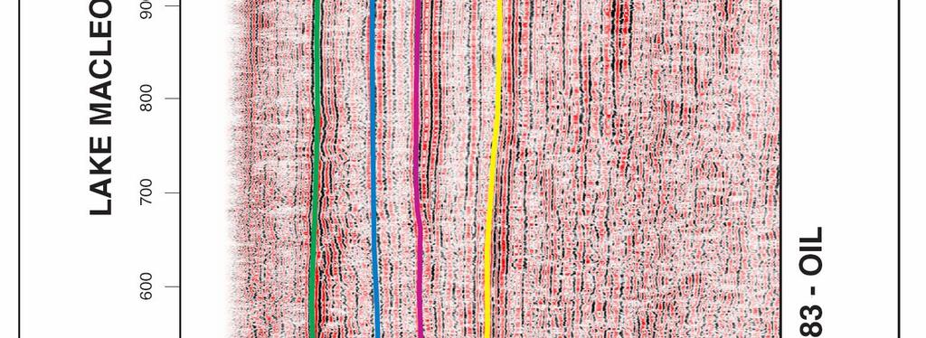
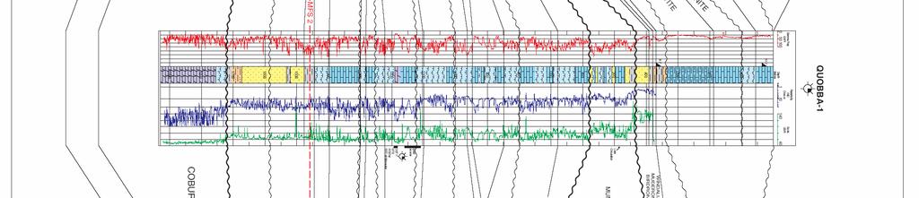
9 5.3 Maturity A thermal maturity map of the lower part of the Gneudna Formation is shown in Figure 5. This is based on cross plots of Tmax versus Production Index cross plots (Gorter et al, 1998); thermal alteration indices (TAI - Analabs, 1984 & 1985 and Purcell, in Mory & Yasin, 1998a) and conodont colour alteration indices (CAI - Gorter et al, 1994 and Mory & Yasin, 1998). The lower Gneudna Formation is immature in Gneudna-1 (Mory, 1996) and in the early oil window in Barrabiddy-1A (Mory & Yasin, 1998), Pendock-1D (Scott & Alexander, 1991) and Qubba-1 (Purcell & Ingram, 1984). The unit is in the gas window in Quail-1 where it was deeply buried beneath thick Permian sediments of the Merlinleigh Sub-basin (Percival & Cooney, 1984). Figure 5 illustrates that the Gneudna Formation source rocks are in the oil window in the northwestern quarter of EP-439 and extend south to the northern flanks of the Lake Macleod Prospect. 5.4 Timing Due to tectonic events which caused uplift and erosion of the Gascoyne Sub-basin during the Mid- Carboniferous, Late Triassic, Late Jurassic and Early Cretaceous, it is not possible to produce a meaningful burial history plot of the Gneudna Formation. However, based on the stratigraphic section onshore (Hocking et al, 1987), there is a mostly continuous sedimentary section from the Middle Devonian Nannyarra Sandstone to the Middle Carboniferous Quail Formation. The section above the Gneudna Formation in the northwest quarter of EP-439 is estimated to have been 2,000 metres thick where a full Late Devonian to Early Carboniferous section would have been present beneath the Base Cretaceous Unconformity. Assuming a normal geothermal gradient of 2.5º to 3.0º C/100 metres, the Gneudna Formation source rocks are predicted to have generated most of their oil during the Early to Mid Carboniferous. The main structures in EP-439 formed either during the Early Devonian Pertnjara Movement or during the Miocene. The Miocene structures (Quobba-1, Pendock-1D and Wandagee-1) all post-date primary hydrocarbon migration and are dry. The Early Devonian structures, however, pre-date primary hydrocarbon migration from the Gneudna Formation source rocks which generated their hydrocarbons during the Late Carboniferous to Permian. None of these aged structures have been drilled in the Gascoyne Sub-basin. 6 SEISMIC INTERPRETATION The initial seismic interpretation was carried out using paper section displays of the 1983 Lyell Range Seismic Survey and the reprocessed B72-1L line from the Lyndon Quobba Seismic Survey. The quality of this seismic is very good (Figures 7) with excellent seismic character providing reliable horizon ties at line intersections. Five seismic horizons were mapped with time structure maps prepared for two of these. The horizons are:
10 (i) Base Cretaceous Unconformity (ii) Intra-Gneudna Event (iii) Top Dirk Hartog Group (Figure 6) (v) Top Tumblagooda Sandstone Significant tectonic movements took place during the Early Devonian Pernjara Movement (Warris, 1994) causing significal vertical uplift and block faulting in parts of the basin. 7 LAKE MACLEOD PROSPECT In Exploration Permit EP-439, the main prospect is the Lake Macleod Prospect. Quobba-1 was drilled on a Miocene compressional anticline with the underlying Devonian sediments dipping to the west. A large structure is present to the east (Figure 6). The Devonian sediments drape over an older Silurian fault block and therefore the Lake Macleod structure has been present since Late Devonian times (Figure 7). Timing of oil migration from the Gneudna Formation source rocks into the Lake Macleod Prospect is excellent. The Devonian section in Quobba-1 is mostly shale so seal is not a problem. There were good oil and gas shows throughout the Gneudna Formation in Quobba-1 and in particular a dolomite at 1,170 metres. This dolomite was open hole drill stem tested and flowed some 1,000 BWPD from about 5 metres of porosity. Permeabilities from this test were good. The Lake Macleod Prospect covers an area of 27,500 hectares (70,000 acres) with a vertical relief of 100 milliseconds (150 metres). Estimated potential recoverable reserves for the Lake Macleod prospect are of the order of 150 million barrels (Table 1). TABLE 1 POTENTIAL RESERVE ESTIMATE LAKE MACLEOD PROSPECT Area 275 sq km 27,500 hectares Maximum Gross Pay 100 milliseconds 150 metres Net Dolomite Pay 5 metres Average Net Pay 5 metres Volume 137,500 hectare-metres Reservoir Porosity = 12% (average) Sw = 40% FVF = 1.2 Oil-in-Place 3,800 barrels/hm 522 million barrels Recovery Factor 30% Recoverable Oil Reserves 155 million barrels
11 8 REFERENCES Analabs, Summary of geochemical, palynological and petrological data for Quobba-1. Unpublished Report. Analabs, Hydrocarbon source rocks characterisation study, Carnarvon Basin regional evaluation. Unpublished Report. Baille, P.W. & Jacobsen, E., Structural Evolution of the Carnarvon Terrace, Western Australia. The APEA Journal, 35 (1) Blake, T., Burgess, I., Saruk, E. & Hartog, D., Quobba No 1 Well Completion Report, Carnarvon Basin, Gascoyne Sub-basin, EP-274. Unpublished Report prepared for Canada Northwest Australia Oil NL. Edwards, D.S., Summons, R.E., Kennard, J.M., Nicoll, R.S., Bradshaw, J., Bradshaw, M., Foster, C.B., O Brien, G.W. & Zumberge, J.F., Geochemical characteristics of Palaeozoic petroleum systems in northwestern Australia. The APEA Journal, 37 (1) Geary, J.K., Offshore Exploration in the southern Carnarvon Basin.The APEA Journal, 10 (1) Ghori, K.A.R., 1998 Palaeozoic petroleum generating potential and thermal history, Carnarvon Basin, Western Australia. In: Purcell, P.G. & R.R. (Eds). West Australian Basins. Proceedings of Petroleum Exploration Society of Australia Symposium, Perth, Gorter, J.D., Nicoll, R.S. & Foster, C.B., Lower Palaeozoic facies in the Carnarvon Basin, Western Australia: stratigraphy and hydrocarbon prospectivity. In: Purcell, P.G. & R.R. (Eds). Sedimentary Basins of Western Australia. Proceedings of Petroleum Exploration Society of Australia Symposium, Perth, 1994, Gorter, J.D., Mory, A. & Nicoll, R.S., Sequence Stratigraphy and Hydrocarbon Potential of the Middle to Upper Devonian (Givetian - Frasnian) in the Carnarvon Basin, Western Australia. In: Purcell, P.G. & R.R. (Eds). West Australian Basins. Proceedings of Petroleum Exploration Society of Australia Symposium, Perth, Hocking, R.M., Moors, H.T. & Van de Graaff, J.E., Geology of the Carnarvon Basin, Western Australia. Geological Survey of Western Australia, Bulletin 133. Klemme, H.D. & Ulmishek, G.F., Effective petroleum source rocks of the world: stratigraphic distribution and controlling depositional factors. American Association of Petroleum Geologists, Bulletin 75, Lambert, M.W., Internal stratigraphy and organic facies of the Devonian-Mississippian Chattanooga (Woodford) Shale in Oklahoma and Kansas. In: Katz, B.J. & Pratt, L.M. (Eds). Source Rocks in a Sequence Stratigraphic Framework. AAPG Studies in Geology #37,
12 Moors, H.T., An alluvial fan-fluvial plain depositional model for the Devonian Willaraddie Formation and Munabia Sandstone of the Carnarvon Basin, Western Australia. Geological Survey of Western Australia Annual Report 1980, Mory, A., GSWA Gneudna 1 Well Completion Report, Merlinleigh Sub-basin, Carnarvon Basin, Western Australia. Geological Survey of Western Australia, Record 1996/6. Mory, A. & Yasin, GSWA Barrabiddy 1 and 1A Well Completion Reports, Wandagee Ridge, Southern Carnarvon Basin, Western Australia. Geological Survey of Western Australia, Record In Press. Nicoll, R.S., A Late Devonian age for the Munabia Sandstone, Carnarvon Basin. Australian BMR Professional Opinion Geol. 79/034. Nicoll, R.S. & Gorter, J.D., Interpretation of the Devonian-Carboniferous stratigraphy of Quail 1, onshore Carnarvon Basin: regional implications for geohistory and hydrocarbon prospectivity, AGSO Journal of Geology & Geophysics, 15 (4) Ormiston, A.R. & Oglesby, R.J., Effect of Late Devonian paleoclimate on source rock quality and location. In: Huc, A.Y. (Ed). Paleogeography, Paleoclimate and Source Rocks. AAPG Studies in Geology, #40, Percival, I.G. & Cooney, P.M., Petroleum geology of the Merlinleigh Sub-basin, Western Australia.The APEA Journal, 25 (1) Purcell, R.R. & Ingram, B., Palynology Report AP38 Palynology and source rock assessment of Quobba No 1. Unpublished Report for Canada Northwest, May, Scott, J. & Alexander, R., Geochemical analysis of Cane River-1, Dirk Hartog-17B, Fortescue-1, Mardie-1, Pendock-1D, Sholl-1, Tamala-1 and Rough Range-1. WA Centre for Petroleum Exploration Curtin University (unpublished). Warris, B.J., The hydrocarbon potential of the Palaeozoic Basins of Western Australia. The APEA Journal, 33 (1) Warris, B.J., The hydrocarbon potential of the onshore Carnarvon Basin. In: Purcell, P.G. & R.R. (Eds). Sedimentary Basins of Western Australia. Proceedings of Petroleum Exploration Society of Australia Symposium, Perth, 1994,


13


14


15


16


17


18


19


20
L.K. Carr 1, R.J. Korsch 1, A.J. Mory 2, R.M. Hocking 2, S.K. Marshall 1, R.D. Costelloe 1, J. Holzschuh 1, J.L. Maher 1. Australia.
 STRUCTURAL AND STRATIGRAPHIC ARCHITECTURE OF WESTERN AUSTRALIA S FRONTIER ONSHORE SEDIMENTARY BASINS: THE WESTERN OFFICER AND SOUTHERN CARNARVON BASINS L.K. Carr 1, R.J. Korsch 1, A.J. Mory 2, R.M. Hocking
Petroleum Potential of the Application Area L12-4
 Petroleum Potential of the Application Area L12-4 The Application Area (L12-4) is underlain by the western Officer Basin, beneath the Gunbarrel Basin. The general basin architecture is outlined in Figure
MUHAMMAD S TAMANNAI, DOUGLAS WINSTONE, IAN DEIGHTON & PETER CONN, TGS Nopec Geological Products and Services, London, United Kingdom
 Geological and Geophysical Evaluation of Offshore Morondava Frontier Basin based on Satellite Gravity, Well and regional 2D Seismic Data Interpretation MUHAMMAD S TAMANNAI, DOUGLAS WINSTONE, IAN DEIGHTON
L.K. Carr 1, R.J. Korsch 1, A.J. Mory 2, R.M. Hocking 2, S.K. Marshall 1, R.D. Costelloe 1, J. Holzschuh 1, J.L. Maher 1
 STRUCTURAL AND STRATIGRAPHIC ARCHITECTURE OF WESTERN AUSTRALIA S FRONTIER ONSHORE SEDIMENTARY BASINS: THE WESTERN OFFICER AND SOUTHERN CARNARVON BASINS L.K. Carr 1, R.J. Korsch 1, A.J. Mory 2, R.M. Hocking
Petroleum geology framework, West Coast offshore region
 Petroleum geology framework, West Coast offshore region James W. Haggart* Geological Survey of Canada, Vancouver, BC jhaggart@nrcan.gc.ca James R. Dietrich Geological Survey of Canada, Calgary, AB and
RELINQUISHMENT REPORT. License P1546 Block April 2009
 RELINQUISHMENT REPORT License P1546 Block 110-01 14 April 2009 Sherritt International Oil and Gas Limited 2000, 425-1 st street S.W., Calgary, Alberta Canada T2P 3L8 Telephone (403) 260-2900 Fax (403)
Depositional History and Petroleum Potential of Ombilin Basin, West Sumatra - Indonesia, Based on Surface Geological Data*
 Depositional History and Petroleum Potential of Ombilin Basin, West Sumatra - Indonesia, Based on Surface Geological Data* Yahdi Zaim 1, Litto Habrianta 2, Chalid I. Abdullah 1, Aswan 1, Yan Rizal 1, Nurcahyo
Petroleum Systems (Part One) Source, Generation, and Migration
 Source, Generation, and Migration") Petroleum Systems (Part One) Source, Generation, and Migration GEOL 4233 Class January 2008 Petroleum Systems Elements Source Rock Migration Route Reservoir Rock Seal Rock Trap Processes Generation Migration
Petroleum Systems (Part One) Source, Generation, and Migration GEOL 4233 Class January 2008 Petroleum Systems Elements Source Rock Migration Route Reservoir Rock Seal Rock Trap Processes Generation Migration
Vail et al., 1977b. AAPG 1977 reprinted with permission of the AAPG whose permission is required for further use.
 Well 5 Well 4 Well 3 Well 2 Well 1 Vail et al., 1977b AAPG 1977 reprinted with permission of the AAPG whose permission is required for further use. Well 5 Well 4 Well 3 Well 2 Well 1 Vail et al., 1977b
RELINQUISHMENT REPORT. UK Traditional Licence P Blocks 12/16b & 12/17b. First Oil Expro Limited (Operator, 46.67%)
") RELINQUISHMENT REPORT UK Traditional Licence P.1887 Blocks 12/16b & 12/17b First Oil Expro Limited (Operator, 46.67%) Nautical Petroleum Limited (26.67%) North Sea Energy (UK NO2) Limited (26.67%) February
RELINQUISHMENT REPORT UK Traditional Licence P.1887 Blocks 12/16b & 12/17b First Oil Expro Limited (Operator, 46.67%) Nautical Petroleum Limited (26.67%) North Sea Energy (UK NO2) Limited (26.67%) February
ONSHORE / OFFSHORE & NEW SHALE POTENTIAL OF MOROCCO
 Kingdom of Morocco ONSHORE / OFFSHORE & NEW SHALE POTENTIAL OF MOROCCO Mr M. NAHIM Mrs N. ESSALLOUMI Key aspects of Morocco Political and economic stability; Economic policy of integration at regional
Structural Geology of the Mountains
 Structural Geology of the Mountains Clinton R. Tippett Shell Canada Limited, Calgary, Alberta clinton.tippett@shell.ca INTRODUCTION The Southern Rocky Mountains of Canada (Figure 1) are made up of several
Meandering Miocene Deep Sea Channel Systems Offshore Congo, West Africa
 Meandering Miocene Deep Sea Channel Systems Offshore Congo, West Africa S. Baer* (PGS), J. E. Comstock (PGS), K. Vrålstad (PGS), R. Borsato (PGS), M. Martin (PGS), J.P. Saba (SNPC), B. Débi-Obambé (SNPC)
BALOCHISTAN FOLDBELT BASIN
 INTRODUCTION BALOCHISTAN FOLDBELT BASIN The Kharan-3 block is located in the Kharan Trough of Balochistan Basin. GEOLOGICAL SETTING The Balochistan Province is an Upper Cretaceous to Recent structurally
Sedimentary Cycle Best Practice: Potential Eo-Oligocene Sediments in Western Indonesia*
 Sedimentary Cycle Best Practice: Potential Eo-Oligocene Sediments in Western Indonesia* Mellinda Arisandy 1 and I Wayan Darma 1 Search and Discovery Article #11008 (2017)** Posted November 6, 2017 *Adapted
A comparison of structural styles and prospectivity along the Atlantic margin from Senegal to Benin. Peter Conn*, Ian Deighton* & Dario Chisari*
 A comparison of structural styles and prospectivity along the Atlantic margin from Senegal to Benin Overview Peter Conn*, Ian Deighton* & Dario Chisari* * TGS, Millbank House, Surbiton, UK, KT6 6AP The
APPENDIX C GEOLOGICAL CHANCE OF SUCCESS RYDER SCOTT COMPANY PETROLEUM CONSULTANTS
 APPENDIX C GEOLOGICAL CHANCE OF SUCCESS Page 2 The Geological Chance of Success is intended to evaluate the probability that a functioning petroleum system is in place for each prospective reservoir. The
BACK TO BASICS WHY THE TORRES BASIN COULD BE A COMPANY MAKER Papua New Guinea :PPL326 A Frontier Basin
 BACK TO BASICS WHY THE TORRES BASIN COULD BE A COMPANY MAKER Papua New Guinea :PPL326 A Frontier Basin 1 Tertiary Carbonate/Clastic Prospects and Leads PNG_LNG Facility PPL326 has a large number of over
EGAS. Ministry of Petroleum
 EGAS Ministry of Petroleum EGAS Ministry of Petroleum About The Block Location: N. Thekah offshore block is located at about 56 km to the north of the Mediterranean shore line, 85 km to the north west
Hydrocarbon Pools Of The Southeastern Great Slave Plain, Northwest Territories
 Hydrocarbon Pools Of The Southeastern Great Slave Plain, Northwest Territories Introduction E.P. Janicki* C.S. Lord Northern Geoscience Centre, Yellowknife, NWT ed_janicki@gov.nt.ca The geology of hydrocarbon
Relinquishment Report
 Relinquishment Report Licence P1403 Block 13/22d Chevron North Sea Limited Korean National Oil Company Chevron North Sea Limited December 2009 1 SYNOPSIS... 3 2 INTRODUCTION. 3 2.1 Licence Terms.. 3 2.2
Overview of Selected Shale Plays in New Mexico*
 Overview of Selected Shale Plays in New Mexico* Ron Broadhead 1 Search and Discovery Article #10627 (2014)** Posted August 18, 2014 *Adapted from presentation at RMAG luncheon meeting, Denver, Colorado,
Devonian Petroleum Systems and Exploration Potential, Southern Alberta, Part 3 Core Conference
 Devonian Petroleum Systems and Exploration Potential, Southern Alberta, Part 3 Core Conference Andy Mort (1), Leonard Stevens (2), Richard Wierzbicki (2) Abstract Part 1: Devonian Petroleum Systems Dr.
Blocks 31, 32, 33, 34, 35 & 36/03 Southeast Offshore Vietnam
 Blocks 31, 32, 33, 34, 35 & 36/03 Southeast Offshore Vietnam Block 31 32 33 34 35 36/03 Area (km 2) 5,036 4,440 4,630 4,700 4,630 2,950 Sea level (m) 20 20-30 30-40 50 50 50 Seismic 2D (km) 1,294 685 431
EGAS. Ministry of Petroleum
 EGAS Ministry of Petroleum EGAS Ministry of Petroleum About The Block Location: N. El Arish offshore block is located in the extreme eastern part of the Egypt s economic water border and bounded from the
Orphan Basin, Offshore Newfoundland: New seismic data and hydrocarbon plays for a dormant Frontier Basin
 Orphan Basin, Offshore Newfoundland: New seismic data and hydrocarbon plays for a dormant Frontier Basin Jerry Smee* G&G Exploration Consulting, 301 400-3rd Avenue SW, Calgary, AB, T2P 4H2 Sam Nader, Paul
The Kingfisher Field, Uganda - A Bird in the Hand! S R Curd, R Downie, P C Logan, P Holley Heritage Oil plc *
 A Bird in the Hand! EXTENDED ABSTRACT The Kingfisher Field, Uganda - A Bird in the Hand! Heritage Oil plc * The Kingfisher Field lies on Uganda s western border beneath Lake Albert, situated in the western
Upper Ordovician reefs in the Hudson Bay Basin: Porosity evolution and hydrocarbon charge
 Upper Ordovician reefs in the Hudson Bay Basin: Porosity evolution and hydrocarbon charge Denis Lavoie 1, Ariane Castagner 2, Omid Haeri Ardakani 3, André Desrochers 2 1 Geological Survey of Canada, Québec
Figure 1 Extensional and Transform Fault Interaction, Influence on the Upper Cretaceous Hydrocarbon System, Equatorial Margin, West Africa.
 Figure 1 Extensional and Transform Fault Interaction, Influence on the Upper Cretaceous Hydrocarbon System, Equatorial Margin, West Africa. Presented to the 10th PESGB/HGS Conference on Africa E + P September
For personal use only
 3 April 2012 MILLIGANS FORMATION OIL PLAY Highlights Competent Persons Report completed on Tangiers Milligans Fan oil play in the Bonaparte Basin Permit Areas WA-442-P and NT/P81 by ISIS Petroleum Consultants.
Image: G. Parker. Presenters: Henry Chan, Kayla Ireland, Mara Morgenstern, Jessica Palmer, Megan Scott
 Image: G. Parker Presenters: Henry Chan, Kayla Ireland, Mara Morgenstern, Jessica Palmer, Megan Scott Is the Ross Formation a suitable analog for sand-rich turbidite plays in passive margin basins? Play:
Controls on clastic systems in the Angoche basin, Mozambique: tectonics, contourites and petroleum systems
 P2-2-13 Controls on clastic systems in the Angoche basin, Mozambique: tectonics, contourites and petroleum systems Eva Hollebeek, Olivia Osicki, Duplo Kornpihl Schlumberger, London, UK Introduction Offshore
The Paleozoic Hudson Bay Basin in Northern Canada: New Insights Into Hydrocarbon Potential of the Last North-America Conventional Frontier Basin*
 The Paleozoic Hudson Bay Basin in Northern Canada: New Insights Into Hydrocarbon Potential of the Last North-America Conventional Frontier Basin* Denis Lavoie 1, Nicolas Pinet 1, Jim Dietrich 2 and Zhuoheng
Evaluation of Neocomian Shale source rock In Komombo Basin, Upper Egypt
 Evaluation of Neocomian Shale source rock In Komombo Basin, Upper Egypt Abdelhady, A. 1, Darwish, M. 2, El Araby, A. 3 and Hassouba, A. 4 1 DEA Egypt, Cairo, Egypt 2 Geology Department, Faculty of Science,
Palatine Energy Pty Ltd
 Palatine Energy Pty Ltd Australian Business Number: 20 153 352 231 Geology and Resource Potential: North Perth Basin (WA STP-EPA-0127) Fig. 1 From: Western Australian Department of Mines & Petroleum letter
6. Cretaceous Zone Play Results
 C H A P T E R S I X 6. Cretaceous Zone Play Results 6. Geological Overview The Mannville Group was deposited as a clastic wedge east of the mountain ranges. This wedge varies in thickness from 7 metres
Case Study of the Structural and Depositional-Evolution Interpretation from Seismic Data*
 Case Study of the Structural and Depositional-Evolution Interpretation from Seismic Data* Yun Ling 1, Xiangyu Guo 1, Jixiang Lin 1, and Desheng Sun 1 Search and Discovery Article #20143 (2012) Posted April
Licence P1368: Relinquishment Report (end of 2 nd term) Hurricane Exploration PLC
 Hurricane Exploration PLC") Licence P1368: Relinquishment Report (end of 2 nd term) Hurricane Exploration PLC March 2012 1. Header Licence Number: P1368 Licence Round: 23 rd Licence Type: Frontier Block Numbers: 202/4, 202/5, 204/30,
Licence P1368: Relinquishment Report (end of 2 nd term) Hurricane Exploration PLC March 2012 1. Header Licence Number: P1368 Licence Round: 23 rd Licence Type: Frontier Block Numbers: 202/4, 202/5, 204/30,
Hydrocarbon Exploration in Morocco: Status & Perspectives
 Hydrocarbon Exploration in Morocco: Status & Perspectives Outline Conventional HC Exploration; Licensing Status; Exploration ancient objectives and New ones Perspectives; Objectives of the Remaining open
Ministry of Oil and Minerals Petroleum Exploration & Production Authority BLOCK 85 (Al Uqlah North)
") Ministry of Oil and Minerals Petroleum Exploration & Production Authority BLOCK 85 (Al Uqlah North) The Al Uqlah North Block (85) occupies an area of 597 km 2 in the Sabatayn Basin in the province of Shabwah
Ministry of Oil and Minerals Petroleum Exploration & Production Authority BLOCK 85 (Al Uqlah North) The Al Uqlah North Block (85) occupies an area of 597 km 2 in the Sabatayn Basin in the province of Shabwah
Testing of the Strawn Sand, White Hat 20#3, Mustang Prospect, Permian Basin, Texas
 Date: 11 April 2019 ASX Code: WEL Directors John Kopcheff Non-Executive Chairman Neville Henry Managing Director Peter Allchurch Non-Executive Director Larry Liu Non-Executive Director Lloyd Flint Company
Modeling of Hydrocarbon generation and expulsion from Tannezuft and Aouinet Ouinine Formations in southern Tunisia North Africa
 Page No. 036-1 Modeling of Hydrocarbon generation and expulsion from Tannezuft and Aouinet Ouinine Formations in southern Tunisia North Africa Mounir Ferjaoui, Abdelaziz Meskini, and Mohamed Hedi Acheche
Fusselman/Devonian Study. of the Midland Basin, Texas
 Fusselman/Devonian Study of the Midland Basin, Texas Fusselman-Devonian Study of the Midland Basin, Texas Overview The Fusselman-Devonian study of the Midland Basin is designed to enhance both exploration
Maturity Modeling of Gomin and South Gomin fields Southern Pattani Basin, Gulf of Thailand
 Maturity Modeling of Gomin and South Gomin fields Southern Pattani Basin, Gulf of Thailand Patinya Jaithan Petroleum Geoscience Program, Department of Geology, Faculty of Science, Chulalongkorn University,
TIARO COAL JOINT VENTURE IRWIN RIVER COAL & COAL SEAM GAS QUEENSLAND TCJV AND WEST AUSTRALIAN COAL SEAM GAS PROJECT
 Suite 2, Mezanine Level, 35-37 Havelock Street WestPerth WA 6000 Telephone (08) 9481 8668 Facsimile: (08) 9322 7211 ASX ANNOUNCEMENT/MEDIA RELEASE 30th September 2008 TIARO COAL JOINT VENTURE IRWIN RIVER
3. The diagram below shows how scientists think some of Earth's continents were joined together in the geologic past.
 1. The map below shows the present-day locations of South America and Africa. Remains of Mesosaurus, an extinct freshwater reptile, have been found in similarly aged bedrock formed from lake sediments
The McCully gas field in southern New Brunswick was discovered in the year 2000 on a joint drilling exploration venture by Corridor Resources Inc.
 1 The McCully gas field in southern New Brunswick was discovered in the year 2000 on a joint drilling exploration venture by Corridor Resources Inc. and Potash Corporation of Saskatchewan. Located about
High-resolution Sequence Stratigraphy of the Glauconitic Sandstone, Upper Mannville C Pool, Cessford Field: a Record of Evolving Accommodation
 Page No. 069-1 High-resolution Sequence Stratigraphy of the Glauconitic Sandstone, Upper Mannville C Pool, Cessford Field: a Record of Evolving Accommodation Thérèse Lynch* and John Hopkins, Department
Relinquishment Report. for. Licence P1605, Block 220/27
 Relinquishment Report for Licence P1605, Block 220/27 November 2013 Licence P.1605 Relinquishment Report August 2012 1 of 11 CONTENT 1 Introduction 2 - Exploration Summary 2.1 Exploration Activity 2.2
Hydrocarbon Exploration in Morocco: Current Activities and Opportunities. H. Jabour
 Hydrocarbon Exploration in Morocco: Current Activities and Opportunities H. Jabour O N H Y M February 06, 2013 Outline Background Hydrocarbon potential of Morocco Non-Conventional Hydrocarbon Resources
Mammoth Cave National Park, Kentucky
 Mammoth Cave National Park, Kentucky Objectives of Today s Lecture Refresher on Sedimentary Depositional Systems and Rock Classifications Transgressive and Regressive Marine Environments Carbonate Depositional
Blocks: 53/15b, 53/19, 53/20, 54/11 & 54/16. Promote Licence P1252 Two Year Report
 Blocks: 53/15b, 53/19, 53/20, 54/11 & 54/16 Promote Licence P1252 Two Year Report Wintershall Noordzee BV October 2006 Contents Contents 1 List of Figures and Tables...2 1. Licence details and work commitments...3
Masila 1: Shallow shelf carbonate facies variability and secondary reservoir development - Saar Formation Masila block, Yemen
 Masila 1: Shallow shelf carbonate facies variability and secondary reservoir development - Saar Formation Masila block, Yemen Kent Wilkinson* Nexen Inc., Calgary, AB kent_wilkinson@nexeninc.com ABSTRACT
Petroleum Prospectivity in the Namibe and Southern Benguela Basins, Offshore Angola
 Petroleum Prospectivity in the Namibe and Southern Benguela Basins, Offshore Angola C. Koch* (PGS), F. Pepe (PGS), R. Vasconcelos (PGS), F. Mathew (PGS), R. Borsato (PGS) & M.P.C. de Sá (Sonangol) SUMMARY
Update - Testing of the Strawn Sand, White Hat 20#3, Mustang Prospect, Permian Basin, Texas
 Date: 15 April 2019 ASX Code: WEL Directors John Kopcheff Non-Executive Chairman Neville Henry Managing Director Peter Allchurch Non-Executive Director Larry Liu Non-Executive Director Lloyd Flint Company
Ministry of Oil and Minerals Petroleum Exploration & Production Authority BLOCK 80 (WADI SARR)
") Ministry of Oil and Minerals Petroleum Exploration & Production Authority BLOCK 80 (WADI SARR) The Wadi Sarr Block (80) occupies an area of 1961 km 2 on the Sayun- Masilah Basin in the central Yemen. Block
Ministry of Oil and Minerals Petroleum Exploration & Production Authority BLOCK 80 (WADI SARR) The Wadi Sarr Block (80) occupies an area of 1961 km 2 on the Sayun- Masilah Basin in the central Yemen. Block
For personal use only
 12 October 2012 Companies Announcement Office Australian Securities Exchange Limited 10th Floor, 20 Bond Street SYDNEY NSW 2000 ADVENT ENERGY LTD SHALE GAS DATA RELEASE MEC Resources Limited (ASX:MMR)
Ministry of Oil and Minerals Petroleum Exploration & Production Authority BLOCK 6 (Iryam)
") Ministry of Oil and Minerals Petroleum Exploration & Production Authority BLOCK 6 (Iryam) The Iryam Block (6) occupies an area of 3,911 km 2 in the Sabatayn Basin in the province of Shabwah in central
Ministry of Oil and Minerals Petroleum Exploration & Production Authority BLOCK 6 (Iryam) The Iryam Block (6) occupies an area of 3,911 km 2 in the Sabatayn Basin in the province of Shabwah in central
Ladyfern, N.E.B.C.: Major Gas Discovery in the Devonian Slave Point Formation
 Page No. 112-1 Ladyfern, N.E.B.C.: Major Gas Discovery in the Devonian Slave Point Formation Thomas Boreen and Kelvin Colquhoun, Apache Canada Ltd., Calgary, Alberta ABSTRACT The Upper Devonian Slave Point
Seismic Stratigraphy of the Fang Basin, Chiang Mai, Thailand Rungsun Nuntajun
 Chiang Mai J. Sci. 2009; 36(1) 77 Chiang Mai J. Sci. 2009; 36(1) : 77-82 www.science.cmu.ac.th/journal-science/josci.html Contributed Paper Seismic Stratigraphy of the Fang Basin, Chiang Mai, Thailand
FY 2013 Annual Technical Report for NCRDS State Cooperative Program
 FY 2013 Annual Technical Report for NCRDS State Cooperative Program SUBSURFACE GAS-SHALE SAMPLES OF THE UPPER DEVONIAN AND LOWER MISSISSIPPIAN WOODFORD SHALE, PERMIAN BASIN, WEST TEXAS AND SOUTHEASTERN
RWE Dea UK SNS Limited (50%), Faroe Petroleum (UK) Limited
, Faroe Petroleum (UK) Limited") 1. Licence information Licence Number P1975 Licence Round 27 th (2012) Licence Type Traditional Blocks 3/28c & 9/3e Licensees Work Programme 2. Synopsis RWE Dea UK SNS Limited (50%), Faroe Petroleum (UK)
1. Licence information Licence Number P1975 Licence Round 27 th (2012) Licence Type Traditional Blocks 3/28c & 9/3e Licensees Work Programme 2. Synopsis RWE Dea UK SNS Limited (50%), Faroe Petroleum (UK)
SEDIMENTARY BASINS BASIN TYPES ACCORDING TO TECTONIC. by Prof. Dr. Abbas Mansour
 SEDIMENTARY BASINS BASIN TYPES ACCORDING TO TECTONIC by Prof. Dr. Abbas Mansour B. Convergent plate margins 10. STABLE CONTINENTAL INTERIOR BASIN E.g. Lake Eyre Basin Intracratonic (= within stable continental
Multiattributes and Seismic Interpretation of Offshore Exploratory Block in Bahrain A Case Study
 Multiattributes and Seismic Interpretation of Offshore Exploratory Block in Bahrain A Case Study Suresh Thampi, Aqeel Ahmed, Yahya Al-Ansari, Ali Shehab, Ahmed Fateh, Anindya Ghosh, Ghada Almoulani. The
Bulletin of Earth Sciences of Thailand. Evaluation of the Petroleum Systems in the Lanta-Similan Area, Northern Pattani Basin, Gulf of Thailand
 Evaluation of the Petroleum Systems in the Lanta-Similan Area, Northern Pattani Basin, Gulf of Thailand Sirajum Munira Petroleum Geoscience Program, Department of Geology, Faculty of Science, Chulalongkorn
Play fairway mapping in the Northeast Atlantic Margin Comparison between mature and immature basins. David Mudge, Joanne Cranswick
 Play fairway mapping in the Northeast Atlantic Margin Comparison between mature and immature basins David Mudge, Joanne Cranswick Contents Ternan North Sea Play fairway mapping Tertiary case study Northeast
Perspectives from Offshore Argentina & Uruguay
 Perspectives from Offshore Argentina & Uruguay A Prospectivity Overview Hannah Kearns October 2018 Introduction Argentina Offshore License Round 1 14 blocks Argentina North, 24 Austral-Malvinas Offshore
SAND DISTRIBUTION AND RESERVOIR CHARACTERISTICS NORTH JAMJUREE FIELD, PATTANI BASIN, GULF OF THAILAND
 SAND DISTRIBUTION AND RESERVOIR CHARACTERISTICS NORTH JAMJUREE FIELD, PATTANI BASIN, GULF OF THAILAND Benjawan KIinkaew Petroleum Geoscience Program, Department of Geology, Faculty of Science, Chulalongkorn
Hydrocarbon plays of the Mid North Sea High: an integrated seismic and basin modelling study
 Hydrocarbon plays of the Mid North Sea High: an integrated seismic and basin modelling study Stephen Corfield, Julian Moore, Maurice Bamford, Andrew Barnwell and Patrick Barnard -OGA Frontier exploration
Elevation s Barnett Oil Play: Its Genesis and Why it Works. April 25, 2018
 Elevation s Barnett Oil Play: Its Genesis and Why it Works April 25, 2018 UL Permian Basin Position Posted: 2018 Horizontal Spuds (IHS Energy) UL 2018 Partners Forum - April 25, 2018 2 April 2013 (Elevation
Future giant discovery in the Outeniqua Basin, offshore South Africa. Anongporn Intawong & Neil Hodgson
 Future giant discovery in the Outeniqua Basin, offshore South Africa Anongporn Intawong & Neil Hodgson Spectrum Geoscience 23 February 2017 1 Talk Outlines Structural framework & Evolution of the South
Tetsuya Fujii. Bachelor of Geology, Shinshu University, Japan Master of Geophysics, the University of Tokyo, Japan
 USING 2D AND 3D BASIN MODELLING AND SEISMIC SEEPAGE INDICATORS TO INVESTIGATE CONTROLS ON HYDROCARBON MIGRATION AND ACCUMULATION IN THE VULCAN SUB-BASIN, TIMOR SEA, NORTH-WESTERN AUSTRALIA By Tetsuya Fujii
Comment on: Cenozoic evolution of the eastern Danish North Sea by M. Huuse, H. Lykke-Andersen and O. Michelsen, [Marine Geology 177, 243^269]
![Comment on: Cenozoic evolution of the eastern Danish North Sea by M. Huuse, H. Lykke-Andersen and O. Michelsen, [Marine Geology 177, 243^269]](/thumbs/93/112023617.jpg "Comment on: Cenozoic evolution of the eastern Danish North Sea by M. Huuse, H. Lykke-Andersen and O. Michelsen, [Marine Geology 177, 243^269]") Marine Geology 186 (2002) 571^575 Discussion Comment on: Cenozoic evolution of the eastern Danish North Sea by M. Huuse, H. Lykke-Andersen and O. Michelsen, [Marine Geology 177, 243^269] P. Japsen, T.
Marine Geology 186 (2002) 571^575 Discussion Comment on: Cenozoic evolution of the eastern Danish North Sea by M. Huuse, H. Lykke-Andersen and O. Michelsen, [Marine Geology 177, 243^269] P. Japsen, T.
Key Elements of the Petroleum Systems of the Rockall and Slyne-Erris Basins
 Key Elements of the Petroleum Systems of the Rockall and Slyne-Erris Basins Bandon Corrib Dooish Atlantic Ireland Conference, Dublin, 1 st - 2 nd November 2016 Rockall and Slyne-Erris Basins Only 11 exploration
East Gainsborough, Saskatchewan: a Prairie Evaporite salt dissolution and Mississippian erosional unconformity trap
 East Gainsborough, Saskatchewan: a Prairie Evaporite salt dissolution and Mississippian erosional unconformity trap Andre St.Onge* and Eric Strachan Upton Resources Inc., 3900, 205-5 th Avenue S.W., Calgary,
Figure 1: PEDL 155 Location Map
 Licence Details UK Onshore Licence PEDL 155 October 2014 Licence Number: PEDL 155 Licence Round: UK 12 th Onshore Licensing Round Effective Date: 1 October 2004 Licence Type: Petroleum Exploration and
EAS 233 Geologic Structures and Maps Winter Miscellaneous practice map exercises. 1. Fault and separation:
 Miscellaneous practice map exercises 1. Fault and separation: With respect to Map 1, what are (a) the orientation of the fault, and (b) the orientation of bedding in the units cut by the fault. (c) Mark
P1645 Fig 1: Licence P1645 Introduction
 Licence Number: P.1645 commenced 12 th November 2008 Licence Round: 25 th Licence Type: Traditional Block Number: 9/8b Operator: EnQuest (60%) Partners: Norwegian Energy Company (Noreco) UK Ltd 40% Work
PETROLEUM GEOLOGY AND GEOPHYSICS OF THE MOZAMBIQUE CHANNEL ANNOUNCEMENT
 PETROLEUM GEOLOGY AND GEOPHYSICS OF THE MOZAMBIQUE CHANNEL ANNOUNCEMENT Rusk, Bertagne & Associates are pleased to announce the completion of a three year study and the publication of a report entitled
Sequence Stratigraphy of the Upper Cretaceous Niobrara Formation, A Bench, Wattenberg Field, Denver Julesburg Basin, Colorado*
 Sequence Stratigraphy of the Upper Cretaceous Niobrara Formation, A Bench, Wattenberg Field, Denver Julesburg Basin, Colorado* Lisa E. Remington LaChance 1 and Mark C. Robinson 1 Search and Discovery Article
The Late Tertiary Deep-Water Siliciclastic System of the Levant Margin - An Emerging Play Offshore Israel*
 The Late Tertiary Deep-Water Siliciclastic System of the Levant Margin - An Emerging Play Offshore Israel* Michael A. Gardosh 1, Yehezkel Druckman 2 and Binyamin Buchbinder 2 Search and Discovery Article
Highstand Stacked Tidal Flat / Standing Water Evaporite Cycles of the Midale Evaporite in Southeast Saskatchewan, Mississippian Williston Basin*
 Highstand Stacked Tidal Flat / Standing Water Evaporite Cycles of the Midale Evaporite in Southeast Saskatchewan, Mississippian Williston Basin* J. H. Lake 1 and D. M. Kent 2 Search and Discovery Article
Pre Stack Imaging To Delineate A New Hydrocarbon Play A Case History
 5th Conference & Exposition on Petroleum Geophysics, Hyderabad-2004, India PP 375-379 Pre Stack Imaging To Delineate A New Hydrocarbon Play A Case History D. Srinivas, T.R. Murali Mohan, Ashwani Lamba,
THE NORTH SUMATERA BASIN : GEOLOGICAL FRAMEWORK & PETROLEUM SYSTEM REVIEW
 THE NORTH SUMATERA BASIN : GEOLOGICAL FRAMEWORK & PETROLEUM SYSTEM REVIEW By the Delegation of Indonesia : Bambang Wicaksono TM* Jonathan Setyoko H* Hermes Panggabean** * Lemigas ** PSG Krabi, 12-15 May
PROSPECT EVALUATION OF UNCONVENTIONAL PLAYS IN RUSSIA EPUG 2014
 PROSPECT EVALUATION OF UNCONVENTIONAL PLAYS IN RUSSIA EPUG 2014 Main definitions AGENDA Shale/shale play definition - Organic matter content - Thermal maturity Potential for unconventionals development
Controls on facies distributions in the Charlie Lake Formation, Peace River Arch, Alberta
 Controls on facies distributions in the Charlie Lake Formation, Peace River Arch, Alberta E.L. Percy 12, C. Frostad 2, A. Juska 2, C. Schmidt 2, C. Sitzler 2, and J.P. Zonneveld 3 University of Calgary,
Mesozoic Earth History
 Mesozoic Earth History The Mesozoic Era 251-66 MYA Breakup of Pangea Changes in air and oceanic currents Evolution of new terrestrial and marine life Opening of the Atlantic Ocean Basin Rocky Mountains
Determination of Geothermal Gradient in the Eastern Niger Delta Sedimentary Basin from Bottom Hole Temperatures
 Journal of Earth Sciences and Geotechnical Engineering, vol. 4, no. 3, 2014, 109-114 ISSN: 1792-9040 (print), 1792-9660 (online) Scienpress Ltd, 2014 Determination of Geothermal Gradient in the Eastern
Lower Skinner Valley Fill Sandstones: Attractive Exploration Targets on the Northeast Oklahoma Platform*
 Lower Skinner Valley Fill Sandstones: Attractive Exploration Targets on the Northeast Oklahoma Platform* By Jim Puckette 1 Search and Discovery Article #10050 (2003) *Adapted from presentation to Tulsa
For personal use only
 ASX ANNOUNCEMENT 11 September 2018 Billion Barrel Oil Potential Assessed in Pancontinental s PEL 87 Offshore Namibia Giant* scale oil potential in multiple Large Leads in PEL 87 Vast Cretaceous Superfan
B.C. s Offshore Oil and Gas: a Guide to the Geology and Resources.
 B.C. s Offshore Oil and Gas: a Guide to the Geology and Resources. Introduction Beneath the offshore regions of British Columbia are four moderately large, geologically young sedimentary basins (Figure
GeoConvention 2012: Vision 1
 Cretaceous possibilities: Sedimentology and reservoir potential of the Early Cretaceous Isachsen Formation of the Sverdrup Basin, Ellef Ringnes Island, Arctic Canada Dylan Tullius Department of Geoscience
Sediment and sedimentary rocks Sediment
 Sediment and sedimentary rocks Sediment From sediments to sedimentary rocks (transportation, deposition, preservation and lithification) Types of sedimentary rocks (clastic, chemical and organic) Sedimentary
Aptian/Albian Reservoir Development in the Jeanne d Arc Basin, Offshore Eastern Canada
 Aptian/Albian Reservoir Development in the Jeanne d Arc Basin, Offshore Eastern Canada Jonathan Marshall, Statoil Canada Ltd. Calgary, Alberta, Canada. jomars@statoil.com Introduction: The Jeanne d Arc
Northern Houtman Sub-basin prospectivity preliminary results
 Northern Houtman Sub-basin prospectivity preliminary results Irina Borissova, Chris Southby, George Bernardel, Jennifer Totterdell, Robbie Morris & Ryan Owens Geoscience Australia, GPO Box 378, Canberra
Origin and Evolution of Formation Waters in the West-Central Part of the Alberta Basin
 Page No. 004-1 Origin and Evolution of Formation Waters in the West-Central Part of the Alberta Basin Karsten Michael* University of Alberta, 1-26 ESB, Edmonton, AB T6G 2E3 karsten@ualberta.ca and Stefan
Lecture 24: Paleozoic 1:
 UNIVERSITY OF SOUTH ALABAMA GY 112: Earth History Lecture 24: Paleozoic 1: Laurentia Instructor: Dr. Douglas W. Haywick Last Time (before the exam) The Cambrian Explosion A) Why a Cambrian explosion B)
Calcite Cements in Middle Devonian Dunedin Formation:
 Geochemistry of the Fracture-Filling Dolomite and Calcite Cements in Middle Devonian Dunedin Formation: Implication for the Strata Dolomitization Model Sze-Shan Yip 1, Hairuo Qing 1 and Osman Salad Hersi
Figure 1: Location and bathymetry of the study area. Gulf of Guinea. Cameroon. Congo. Gabon. PGS/DGH Gabon MegaSurvey Coverage (35000Km 2 ) Eq.
 Eq.") Deepwater hydrocarbon prospectivity analysis of offshore North and South Gabon Muhammad S Tamannai (*), Thomas Hansen (1), Ron Borsato (1), Jennifer Greenhalgh (1) Martial-Rufin Moussavou (2) & Landry
Deepwater hydrocarbon prospectivity analysis of offshore North and South Gabon Muhammad S Tamannai (*), Thomas Hansen (1), Ron Borsato (1), Jennifer Greenhalgh (1) Martial-Rufin Moussavou (2) & Landry
Implications of the Rabat Deep 1 exploration well on the prospectivity of the surrounding area
 Transformational Growth Through Exploration Implications of the exploration well on the prospectivity of the surrounding area Morocco Brazil Namibia South Atlantic 100 Ma Reconstruction Growth through