Plan of the presentation
|
|
|
- Tracey Watson
- 6 years ago
- Views:
Transcription
, Lesser Antilles Plan")


 Tsunamis T i in i the th")
1 Inundation Risks for the French West Indies (Guadeloupe & Martinique), Lesser Antilles Plan of the presentation F.W.I. Historical data of Tsunamis Numerical simulations of historical Tsunamis Narcisse Zahibo Laboratory of Reasearch in Geosciences and Energie (LARGE) Numerical simulation of potential tsunamis Attempt Surges of Modelling of Hurricane Storm The month of Science, Tallinn, November 7, 211 The Greater and Lesser Antilles Geodynamics of Caribbean North Atlantic Ocean Subduction Zone Seismicity in Caribbean Tsunamigenic earthquakes Shallow earthquackes (< 5 km) Tsunamis T i in i the th Caribbean C ibb Today : about 1 events Magnitude > 6.3 1
 3 Teletsunamis 1755 Lisbon, Portugal 1929 Terre-Neuve, Canada 24 Indian Ocean 7 Volcanic Tsunamis - Martinique, Volcano Mont-Pelée 192 : May 5, 8, 18-2 and August 3 -")


2 Tsunamigenic earthquakes Thrust Strike-slipt Normal F.W.I. Tsunamis data base (2 events) 3 Teletsunamis 1755 Lisbon, Portugal 1929 Terre-Neuve, Canada 24 Indian Ocean 7 Volcanic Tsunamis - Martinique, Volcano Mont-Pelée 192 : May 5, 8, 18-2 and August 3 - Montserrat, Volcano Soufriere 1997, 23, 26 1 seismic Tsunamis 169, 1767, 1823, 1827, 1839, 1842, 1843, 1867, 1985, 24 Historical testimonies : 18 m of tsunami in Guadeloupe Numerical Simulations of Historical Tsunamis 1755 Lisbon Tsunami 1867 Virgin Island 23 Montserrat Volcano tsunami The 1755 Lisbon Earthquake The coordinates of the earthquake epicenter are known approximately Picture of Tsunami in Lisbon Documented felt area Mw : November 1, 1755 Tsunami propagated through the Atlantic Ocean and reached the Lesser Antilles British Virgin Islands Lesser An ntilles 7 m Sabs St Kitts St Bartholomew St Martin 4.5 m Montserrat 4.5 m Barbuda Antigua 3.6 m Guadeloupe Grenada 3.6 m Dominique 1.8 m Martinique St Lucia St Vincent Run up Barbados 1.5 m Description of 1755 Tsunami NGDC, 26 The sea waves swept across the Atlantic and were observed in several of the West Indian Islands, where the usual rise of the tide is little more than 2 feet [6 cm]. An extraordinary motion of the waters was observed 6 hours after the first shock was felt at Lisbon. In St. Martin, the sea retired so far that a sloop, riding at anchor in 15 feet [4.6 m] of water, was laid dry on her broadside. In Martinique and most of the French Islands, it overflowed the low land, and returned quickly to its former boundaries. In that remarkable flux and reflux of the sea, some places were left dry on about a mile [1.5 km]. Near Fort-de-France, sea withdrew 1.6 km and returned to inundate the upper floors of houses. Morton et al, 26 Probable geological evidence of the 1755 tsunami on the east coast of Guadeloupe 2
 21 Slip Dislocation (m) 19 Gorringe Bank (Jonhston, 1996) Gudalquivir Bank (Baptista, 23) Dip Angle (deg) 15 Rake Angle (deg) 1 Strike Strike Angle (deg. CW) Angle (deg.")
 4 35 m 7 6 4 3 2-1 -2 3-16 -14-12 -1-8 -6-4 -2-16 -14-12 -1-8 -6-4 -2-16 -14-12 -1-8 -6-4 -2-3 Shallow Water Theory in numerical simulation 2 M 1 M")
 in the Project acronymed TRANSFER (Tsunami Risk And Strategies")
 + h is the total water depth http://namidance.ce.metu.edu.")
3 Possible locations of the rupture areas (Guster, 26) Marquis de Plombal (Zitelini, 21, Gracia, 23) Selected rupture parameters Source I/II/III Focal Depth (km) 22 Fault Length (km) 18 Fault Width (km) 21 Slip Dislocation (m) 19 Gorringe Bank (Jonhston, 1996) Gudalquivir Bank (Baptista, 23) Dip Angle (deg) 15 Rake Angle (deg) 1 Strike Strike Angle (deg. CW) Angle (deg. CW) : 15 / 815/8/55 / 55 Maximum Positive Amplitude (m) 8.14 Okada 1985, Elevation = 8.14m, Depression = 2.66m Minimum Negative Amplitude (m) Horseshoe Fault (Fukao, 1973, Levret 1991) 4 35 m Shallow Water Theory in numerical simulation 2 M 1 M 1 MNcosθ gd η = fn t R θ λ D cos Rcosθ θ D Rcosθ λ 2 N 1 MN 1 N cosθ gd η = fm t R cosθ λ D R cosθ θ D R θ η t R 1 cosθ M λ θ N cosθ Numerical Code NAMI DANCE NAMI DANCE was tested, validated and verified together with other internationally accredited tsunami computational tools (such as MOST, TUNAMI N2, COMCOT) in the Project acronymed TRANSFER (Tsunami Risk And Strategies for European Region) funded by the European Commission. is the water surface displacement, M and N are components of water discharge fluxes D = (x,y) + h is the total water depth Domain 1 min (GEBCO Digital Atlas, British Oceanographic Data Centre) Tsunami travel time in minutes (source I) Full reflection on land; free passage on open boundaries Travel time when the water elevation exceeds 15 cm (uplift or subsidence) 3


.")
4 Source 1 Distribution of tsunami waves amplitudes in Atlantics (source 1) Snapshots, 7 hours Florida and Bahamas (2 cm in the open ocean, up to 1 m near Bahamas) Maximum Amplitude Source 2 Minimum Amplitude Brazil (-2 cm in the ocean) Source 3 The first main conclusion from the simulations is that in the case of tsunami generated in the vicinity of the Portuguese coast, the tsunami energy is directed towards Brazilian and Florida coasts and the region near Lesser Antiles remains less affected. Source 1 Source 2 Similar results have recently been obtained by Lovholt et al (28), who studied tsunami source located near the Canary Islands, and it demonstrates similar characteristics of tsunami propagation in the Atlantics. Source 3 Source 1 Computed Wave Amplitudes at north of Guadeloupe are 4-5 cm (wave height is approximately 1 m). Source 2 Synthetic Tide-gauge Record Northern Guadeloupe Source 3 Runup ratio for the tsunami is 2-3 Tsunami runup height can reach m 4


5 Computed Tide-gauge Synthetic Mariogram 5


6 Distribution of tsunami amplitudes along northern and north-eastern coasts of Guadeloupe Red points - locations where tsunami amplitude exceeds 1m Pointe des Chateaux, 2.17 m; Petit-Canal, 1.42 m Pointe à Bacchus, near Petit-Bourg,.95 m Martinique 6


7 Red points - locations where tsunami amplitude exceeds 1m 1.5 m in Bain du Simon; 1.4 m near Sainte Marie; 1.14 m in Pointe de la Batterie; 1.12 m in Sainte-Anne; 1 m in La Trinité and Pointe Banane. Distribution of wave amplitude along eastern coast of Martinique 7


, which broke over the")
8 The Main Results Tsunami energy is divided into two parts: (Florida and the Bahamas) and Brazil. Pointe des Chateaux, East of Guadeloupe, amplitude - 217m 2.17 Bain du Simon, Martinique 1.5 m Observations: Guadeloupe 2-3 m Martinique 1.8 m The 1867 Virgin Tsunami M = 7.5, Depth < 3km, Multi-shock Earthquakes A great sea wave was started by the first shock, and a second larger one by the second shock some ten minutes later; Other waves followed but were relatively unimportant Description of the tsunami in the local newspaper of Guadeloupe St. Thomas, Virgin Island fifteen minutes after the great jolt of November 18, the sea formed, at the entry of the bays, a bar of more than 1 meters height whichprecipitatedonthecitylike an avalanche; but the floods, broken on its passage on the white rocks which are in the middle of the passage, have decreased their violence Description of the tsunami in the local newspaper of Guadeloupe Ste. Rose, Guadeloupe sea has suddenly withdrawn to more than one hundred meter from the littoral and then returned in a wave at least 6 feet high ( 18m), which broke over the shore and carried off all floatable objects The 1867 Virgin Island Tsunami Analyse of the tsunami directivity Fault Length 12 km, Width 3 km 18.N 65.W Mw = 7.5 Depth = 3 km distribution of positive amplitudes S1 // Latitude S2, S3, S4 at 15, 2, 25 8


9 2 m 1 S1 Influence of the source orientation Deshaies, Guadeloupe 2 m S2 1 Snapshots -1 S min 12 2 m S3 S min 12-1 S min 12 2 m S4 S min Observed data and numerical results for different sources Correlation :.16 (.63 without Deshayes & Ste Rose) t, m Height Observations S1 S2 S3 S4 The Tsunami generated by the volcano eruption on July 12-13, 23 at Montserrat 2 Arroyo Tortola Christensted Antigua Basse-Terre St. George's San Juan Yabucoa St Thomas Fredericksted Ste Rose Gouyave Deshayes Grenadines Dome growing from February 22 to February 23 Crater January 24 Pyroclastic Flow July 23 Tar River Valley Tsunami generation 9


 6 m")


 Numerical tide records (blue")
.")

 3 4 5 6 Vieux-Bourg.8 Time (min).")
10 Tsunami field in Montserrat Tsunami Field Survey in Guadeloupe Bursting in the river mouth in Deshaies 4 m at 1-2 m in the lands Malendure : 7 cm Modeling of the 23 Montserrat Tsunami - Dispersive model with Boussinesq, FUNWAVE - Non Dispersive model with NLSW, TUNAMI Distribution of maximum elevation (non-dispersive model) 6 m near the source m constructed batymetry file with tide gaude distibution Numerical tide records (blue OFFSHORE solid line non dispersive flow, black.6.8 dotted line dispersive flow) Numerical tide records (blue solid line non dispersive flow, black Saint-Louis.2 Capesterre-Belle-Eau.3 dotted line dispersive flow).2 Water elevation (m) Water elevation (m) Time Time (min) (min) Water elevation (m) Water elevation (m) Vieux-Bourg.8 Time (min) Time (min) Water elevation (m) Water elevation (m) Port-Louis Time (min) Time (min) 1


11 Potential Tsunamis in Guadeloupe from the subduction zone Subduction zone characterized par a set of blocks precomputed N. Atl. Plate Carib. Plate Nested grids : A, B, C 12 C grids around Guadeloupe Initial water displacement Okada model (1985) Tsunami animation Elevation 3.9 m Depression 1.8 m 11


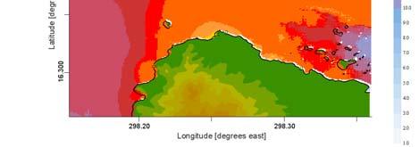

12 4 m 5 m Beach of Sainte Anne Marina of St. François Arrival time 25 mn Arrival time 25 mn Inundation Zone in Ste. Anne St. François Ste. Anne St. François Deshaies (West coast) Inundation Zone in Deshaies Waves amplitude in Martinique, Ford-de-France Inside A grid Maximum inundation zone 12


13 The need of elevation data Topographic and bathymetric data = D.E.M. (Digital Elevation Models) Update of the Caribbean Tsunamis data base NGDC tsunami database Global CMT Catalog Harvard The Research of the Worst Scenarios Building a bank of scenarios for all te blocks : in progress Update of the Caribbean Seismic Synthesis N. Atl. Plate Carib. Plate Monitoring all the sources parameters Main Results The nonlinear hyperbolic shallow-water system is an effective tool to compute the propagation and runup of the tsunami waves. Modeling is one of the major component of Assessment and Mitigation of Tsunamis Accurate Bathymetry, Valid, Verified, Faster Computational Tools are essential in Modeling Determination of possible Source Mechanisms and Rupture Characteristics in Relation to Tsunami Generation Storm surges induced by cyclones in Guadeloupe (334 years) 162 cyclones simulate propagation and coastal amplification of long waves in irregular topographies provide data for comparison and discuss analytical and experimental results 13


, tropical fruits and sugar cane (7% of production")


 Extreme waves induced by Hurricane Dean Severely damaged territories The main damage observed in Grande Terre during")
.")
14 Statistical Analysis Historical data of storm surges Table. Damaging cyclones in Lesser Antilles Both Atlantic and Caribbean coasts of the island exposed to extreme waves, the mean value of storm surge height for the Atlantic coast (2.2 meters) is twice lower than for the Caribbean one (4.4 meters). The most dangerous regions are observed in the southern shore of Grande Terre: Gosier, Sainte Anne and Saint François. Locations and dates of extreme waves in Guadeloupe in Extreme waves induced by Hurricane Dean Extreme waves induced by Hurricane Dean Cyclone general information Hurricane Dean on August 2 at 18:41 UTC, NOAA DeancrossedtheAntilleanarcinAugust, 16 17, 27. After traversing the channel Sainte Lucie, Dean reached to the 3 rd stage of SSS, its average wind speed was in the order of km/h with blasts of 2 km/h. Two deaths were caused by Dean in Martinique. Great damage occurred in the French territories: trees were overthrown and root out; roads were destroyed. Some beaches of white sand disappeared under the water. But the most considerable damage occurred to bananas (1% of production in Martinique and 8% in Guadeloupe), tropical fruits and sugar cane (7% of production in Martinique) Field survey of Guadeloupe was carried out two days after hurricane passage by a survey team from the University of Antilles Guyane: Prof. Narcisse Zahibo, MSc student Irina Nikolkina and Dr. Ira Didenkulova. Severely damaged territories Grande Terre was especially damaged by storm surges. This amplification could be caused bybottom topography asthe beaches in Grand Terre are the flattest. The most damaged territories were located in the northern coast of the Caribbean shore, St Anne, St Félix and Petit Havre. Destroyed berth, Petit Havre Hurricane track: August, 13 23, 27 Destroyed berth, Gosier Beach of Saint Felix: before the hurricane, February 27 (left); after the Hurricane Dean, August 27 (right) Extreme waves induced by Hurricane Dean Severely damaged territories The main damage observed in Grande Terre during the field survey included soil degradation, inundation (Sainte Anne), destruction of littoral buildings (Petit Havre), and debris of marine origin up to 5 6 meters inshore (Saint Felix). Extreme waves induced by Hurricane Dean Severely damaged territories North western part of Basse Terre was damaged mainly by wind. The field survey results showed that the most significant damage was caused in north and north western parts of Basse Terre (Vieux Habitants, Malendure). Beach of Sainte Anne : before the hurricane, December 25 (left); after the Hurricane Dean, August 27 (right) Extreme left sea grass several meters inshore in Malendure (on the photo: Dr. Ira Didenkulova) Damage in Vieux Habitants The beach of Petit Havre Fallen palms, Sainte Anne Damage in Basse Terre 14


, where storm surges of 3")


15 Extreme waves induced by Hurricane Dean Extreme waves induced by Hurricane Dean Tide gauge data In Guadeloupe 4 tide gauges are located in average depth of 2 meters in Deshaies, Bouillante, Vieux Habitants and Gourbeyre. According to records storm surges in Deshaies reached 3 m height. Caribbean coast especially south of Grande Terre and west of Basse Terre were damaged significantly. The field survey results mark that Deshaies was slightly damaged by wind, not by sea waves. Records of sea, Deshaies; August, 27 However there was some water inside the tide gauges. This statement is in a good agreement with data of the western part of Basse Terre (Vieux Habitants), where storm surges of 3 4 meters height were observed. Apparently the amplitude of storm surges might have had the similar order in all Basse Terre. The atmospheric pressure is in an obvious correlation with sea waves; so called rule of reverse barometer. Records of atmospheric pressure, Deshaies; August, 27 Locations and amplitude of storm surges produced by Hurricane Dean (run up height: big underlined letters, run up length: small letters) Storm surges in Vieux Habitants Numerical simulation of long wave generation by hurricane "Lilli» with NSW Hurricane Surges : Mathematical Model S = S1 + S2 + S3 Trajectory of "Lilli" P Depression W W cos Towards the coast f Along the coast Data of "Lilli" on his trajectory Preliminary modelling of wave generation by hurricane "Lilli" Evolution of cyclone and wave generation Shallow Water Theory 15


16 Computed sea level oscillations in Guadeloupe during Lilli passing Test of Numerical Simulation of Hurricane surges in Haiti with SWAN Code Wind map of Hurricane Fay (16/8/28) at 16h3 and 19h3 UTC Significative wave hight at 16h3 and 19h3 THANK YOU FOR YOUR ATTENTION Significative pick periods at 16h3 and 19h3 16
Statistical analysis of cyclone activity for Guadeloupe. Irina Nikolkina*,**, Narcisse Zahibo*, and Ira Didenkulova***
 Statistical analysis of cyclone activity for Guadeloupe Irina Nikolkina*,**, Narcisse Zahibo*, and Ira Didenkulova*** *Laboratory of Tropical and Atmospheric Physics, University of Antilles Guyane, Guadeloupe
TSUNAMI HAZARD ASSESSMENT IN NORTHERN EGYPT USING NUMERICAL SIMULATION
 TSUNAMI HAZARD ASSESSMENT IN NORTHERN EGYPT USING NUMERICAL SIMULATION Abutaleb Ali Supervisor: Bunichiro SHIBAZAKI MEE16717 Yushiro FUJII ABSTRACT To investigate the tsunami hazard along the northern
Trans-Atlantic Propagation of 1755 Tsunami and Its Effects on the French West Indies
 30 The Open Oceanography Journal, 2011, 5, 30-41 Open Access Trans-Atlantic Propagation of 1755 Tsunami and Its Effects on the French West Indies Narcisse Zahibo 1, Efim Pelinovsky *,1,2,3, Ahmet Yalciner
Effect of the Emperor seamounts on trans-oceanic propagation of the 2006 Kuril Island earthquake tsunami
 GEOPHYSICAL RESEARCH LETTERS, VOL. 35, L02611, doi:10.1029/2007gl032129, 2008 Effect of the Emperor seamounts on trans-oceanic propagation of the 2006 Kuril Island earthquake tsunami S. Koshimura, 1 Y.
HURRICANE FRANCES CHARACTERISTICS and STORM TIDE EVALUATION
 HURRICANE FRANCES CHARACTERISTICS and STORM TIDE EVALUATION ((DRAFT)) By Robert Wang and Michael Manausa Sponsored by Florida Department of Environmental Protection, Bureau of Beaches and Coastal Systems
TSUNAMI GENERATED BY THE VOLCANO ERUPTION ON JULY 12-13, 2003 AT MONTSERRAT, LESSER ANTILLES
 TSUNAMI GENERATED BY THE VOLCANO ERUPTION ON JULY 12-13, 2003 AT MONTSERRAT, LESSER ANTILLES Efim Pelinovsky 1), Narcisse Zahibo 2), Peter Dunkley 3), Marie Edmonds 4), Richard Herd 4), Tatiana Talipova
MODELING OF TSUNAMI GENERATION, PROPAGATION COAST FROM THE AZORES CONVERGENCE ZONE AND REGIONAL IMPACT ALONG THE UPPER U.S. EAST
 MODELING OF TSUNAMI GENERATION, PROPAGATION AND REGIONAL IMPACT ALONG THE UPPER U.S. EAST COAST FROM THE AZORES CONVERGENCE ZONE BY ANNETTE R. GRILLI AND STEPHAN T. GRILLI DEPT. OF OCEAN ENGINEERING, UNIVERSITY
HURRICANE JEANNE CHARACTERISTICS and STORM TIDE EVALUATION
 HURRICANE JEANNE CHARACTERISTICS and STORM TIDE EVALUATION ((DRAFT)) By Robert Wang and Michael Manausa Sponsored by Florida Department of Environmental Protection, Bureau of Beaches and Coastal Systems
NUMERICAL SIMULATION AS GUIDANCE IN MAKING TSUNAMI HAZARD MAP FOR LABUAN ISLAND
 NUMERICAL SIMULATION AS GUIDANCE IN MAKING TSUNAMI HAZARD MAP FOR LABUAN ISLAND MOHD RIDZUAN bin Adam Supervisor: Fumihiko IMAMURA MEE09199 ABSTRACT At the northeast end of the South China Sea, tsunamis
2. Tsunami Source Details
 2. Tsunami Source Details The Northland area faces a range of potential tsunamigenic sources that include several local and distant fault systems and underwater landslides. A NIWA study (Goff et al. 2006)
TSUNAMI PROPAGATION AND INUNDATION MODELINGS ALONG SOUTH-EAST COAST OF PAPUA NEW GUINEA
 TSUNAMI PROPAGATION AND INUNDATION MODELINGS ALONG SOUTH-EAST COAST OF PAPUA NEW GUINEA Martin WAREK Supervisor: Yushiro FUJII MEE12620 Bunichiro SHIBAZAKI ABSTRACT This study covers tsunami generation,
Climate Change Impacts and Adaptation for Coastal Transport Infrastructure in Caribbean SIDS
 UNCTAD National Workshop Saint Lucia 24 26 May 2017, Rodney Bay, Saint Lucia Climate Change Impacts and Adaptation for Coastal Transport Infrastructure in Caribbean SIDS Impacts of Natural Hazards on the
Tsunami and earthquake in Chile Part 2
 EUROPEAN COMMISSION DIRECTORATE GENERAL JRC JOINT RESEARCH CENTRE Institute for the Protection and Security of the Citizen Global Security and Crisis Management Unit CriTech Sunday, 28 February 2010 Executive
DIRECTION INTERREGIONALE ANTILLES-GUYANE
 DIRECTION INTERREGIONALE ANTILLES-GUYANE SUMMARY OF THE 2010 HURRICANE SEASON IN THE FRENCH WEST INDIES ( Martinique, Guadeloupe, St Barthelemy and St Martin ) Among the nineteen named tropical cyclones
Tropical Cyclone Isaac (AL092012)
") Tropical Cyclone Isaac (AL092012) Event Briefing, Central Caribbean Impacts Caribbean Risk Managers Ltd Facility Supervisor 27 August 2012 Facility Supervisor: Caribbean Risk Managers Ltd Email: ccrif@ccrif.org
Tropical Cyclone Isaac (AL092012) Event Briefing, Central Caribbean Impacts Caribbean Risk Managers Ltd Facility Supervisor 27 August 2012 Facility Supervisor: Caribbean Risk Managers Ltd Email: ccrif@ccrif.org
NUMERICAL SIMULATION OF TSUNAMI PROPAGATION AND INUNDATION ALONG THE RAKHINE COAST AREAS IN MYANMAR
 NUMERICAL SIMULATION OF TSUNAMI PROPAGATION AND INUNDATION ALONG THE RAKHINE COAST AREAS IN MYANMAR Su Hninn Htwe Supervisor: Bunichiro SHIBAZAKI MEE12619 Yushiro FUJII ABSTRACT This study aimed to assess
Location Option Details. 1. Florida
 1. Florida Florida has the smallest number of earthquaes in the United States. Florida is the U.S. location where hurricanes are most frequent. Of the six deadliest hurricanes to hit the continental U.S.,
Dr. ELIAS A., International Day for Disaster Risk Reduction, AUB - 15 Oct 2012
 3/3/14 Dr. Ata ELIAS, Geology department AUB Outline 1. Tsunami events: 2. The physical and geological tsunami event 3. Global tsunami mitigation efforts Tsunami hazard 1. The tsunami hazard in the Mediterranean
Earthquake Hazards. Tsunami
 Earthquake Hazards Tsunami Review: What is an earthquake? Earthquake is the vibration (shaking) and/or displacement of the ground produced by the sudden release of energy. The point inside the Earth where
Climate Change Impacts and Adaptation for Coastal Transport Infrastructure in Caribbean SIDS
 UNCTAD National Workshop Jamaica 30 May 1 June 2017, Kingston, Jamaica Climate Change Impacts and Adaptation for Coastal Transport Infrastructure in Caribbean SIDS Impacts of Natural Hazards on the Transport
Magnitude 7.7 QUEEN CHARLOTTE ISLANDS REGION
 A major 7.7 magnitude earthquake struck at 8:04 PM local time in western British Columbia, Canada. The epicenter is located on Moresby Island, the southern large island in the Queen Charlotte Islands region.
TSUNAMI CHARACTERISTICS OF OUTER-RISE EARTHQUAKES ALONG THE PACIFIC COAST OF NICARAGUA - A CASE STUDY FOR THE 2016 NICARAGUA EVENT-
 TSUNAMI CHARACTERISTICS OF OUTER-RISE EARTHQUAKES ALONG THE PACIFIC COAST OF NICARAGUA - A CASE STUDY FOR THE 2016 NICARAGUA EVENT- Amilcar Cabrera Supervisor: Yuichiro TANIOKA MEE16718 ABSTRACT Nicaragua
Tsunami waveform analyses of the 2006 underthrust and 2007 outer-rise Kurile earthquakes
 Author(s) 2008. This work is licensed under a Creative Commons License. Advances in Geosciences Tsunami waveform analyses of the 2006 underthrust and 2007 outer-rise Kurile earthquakes Y. Tanioka 1, Y.
Tropical Cyclone Harvey (AL092017)
") Tropical Cyclone Harvey (AL092017) Wind and Storm Surge Preliminary Event Briefing Windward Islands 20 August 2017 Registered Office: CCRIF SPC c/o Sagicor Insurance Managers Limited, 198 North Church
Tropical Cyclone Harvey (AL092017) Wind and Storm Surge Preliminary Event Briefing Windward Islands 20 August 2017 Registered Office: CCRIF SPC c/o Sagicor Insurance Managers Limited, 198 North Church
News Release December 30, 2004 The Science behind the Aceh Earthquake
 News Release December 30, 2004 The Science behind the Aceh Earthquake PASADENA, Calif. - Kerry Sieh, the Robert P. Sharp Professor of Geology at the California Institute of Technology and a member of Caltech's
Earthquake Hazards. Tsunami
 Earthquake Hazards Tsunami Review: What is an earthquake? Earthquake is the vibration (shaking) and/or displacement of the ground produced by the sudden release of energy. The point inside the Earth where
NUMERICAL SIMULATIONS FOR TSUNAMI FORECASTING AT PADANG CITY USING OFFSHORE TSUNAMI SENSORS
 NUMERICAL SIMULATIONS FOR TSUNAMI FORECASTING AT PADANG CITY USING OFFSHORE TSUNAMI SENSORS Setyoajie Prayoedhie Supervisor: Yushiro FUJII MEE10518 Bunichiro SHIBAZAKI ABSTRACT We conducted numerical simulations
Earthquake Hazards. Tsunami
 Earthquake Hazards Tsunami Measuring Earthquakes Two measurements that describe the power or strength of an earthquake are: Intensity a measure of the degree of earthquake shaking at a given locale based
REAL-TIME TSUNAMI INUNDATION FORECAST STUDY IN CHIMBOTE CITY, PERU
 REAL-TIME TSUNAMI INUNDATION FORECAST STUDY IN CHIMBOTE CITY, PERU Nabilt Moggiano Supervisor: Kenji SATAKE MEE16720 ABSTRACT For rapid forecast of tsunami inundation during a tsunamigenic event, we constructed
Preliminary Study of Possible Tsunami Hazards in Taiwan Region
 Preliminary Study of Possible Tsunami Hazards in Taiwan Region Xiaoming Wang and Philip L.-F. Liu Cornell University (First Draft on May 25 2006) (Second Draft on June 1 2006) (Final Update on June 8 2006)
Cascadia Seismic Event Planning for the Maritime Community
 Cascadia Seismic Event Planning for the Maritime Community Jonathan Allan, Oregon Dept. of Geology and Mineral Industries Presentation to Annual Pacific Northwest Waterways Association Meeting (PNWA) October
Tsunami Simulation of 2009 Dusky Sound Earthquake in New Zealand
 Tsunami Simulation of 2009 Dusky Sound Earthquake in New Zealand Polina Berezina 1 Institute of Geology, Taras Shevchenko National University of Kyiv, Kyiv, Ukraine Supervisor: Prof. Kenji Satake Earthquake
VALIDATION OF TSUNAMI INUNDATION MODELING FOR THE 2004 SUMATRA-ANDAMAN EARTHQUAKE FOR MAKING HAZARD MAPS IN PENANG AND LANGKAWI, MALAYSIA
 Synopses of Master Papers Bulletin of IISEE, 47, 11-16, 013 VALIDATION OF TSUNAMI INUNDATION MODELING FOR THE 004 SUMATRA-ANDAMAN EARTHQUAKE FOR MAKING HAZARD MAPS IN PENANG AND LANGKAWI, MALAYSIA Noor
Hazards in the Seattle Area. Disaster Questions. Where Were You? Where Were You? Volcanoes St. Helens Adams, Rainier, Glacier, Baker
 Hazards in the Seattle Area Volcanoes St. Helens Adams, Rainier, Glacier, Baker Earthquakes Outer coast Puget Sound (Seattle Fault & others) Tsunami Outer coast Puget Sound (Seattle Fault & others) Disaster
SCIENCE OF TSUNAMI HAZARDS
 SCIENCE OF TSUNAMI HAZARDS ISSN 8755-6839 Journal of Tsunami Society International Volume 29 Number 3 2010 POTENTIAL DEFICIENCIES IN EDUCATION, INSTRUMENTATION, AND WARNINGS FOR LOCALLY GENERATED TSUNAMIS
HURRICANE CHARLEY CHARACTERISTICS and STORM TIDE EVALUATION
 HURRICANE CHARLEY CHARACTERISTICS and STORM TIDE EVALUATION By Robert Wang, Michael Manausa And Jenny Cheng Sponsored by Florida Department of Environmental Protection, Bureau of Beaches and Coastal Systems
Tropical Storm Isaac. INFORMATION NOTE No. 3 AS OF 8:00 PM (AST) ON SEPTEMBER 12, Synopsis of Tropical Storm Isaac
 ON SEPTEMBER 12, Synopsis of Tropical Storm Isaac") Synopsis of Tropical Storm Isaac LOCATION: 260 MILES EAST NORTH EAST OF MARTINIQUE PRESENT MOVEMENT: WEST AT 20 MPH MAXIMUM SUSTAINED WINDS: 60 MPH MINIMUM CENTRAL PRESSURE: 1003 MB WATCHES AND WARNINGS
Synopsis of Tropical Storm Isaac LOCATION: 260 MILES EAST NORTH EAST OF MARTINIQUE PRESENT MOVEMENT: WEST AT 20 MPH MAXIMUM SUSTAINED WINDS: 60 MPH MINIMUM CENTRAL PRESSURE: 1003 MB WATCHES AND WARNINGS
Indian Ocean Tsunami Warning System: Example from the 12 th September 2007 Tsunami
 Indian Ocean Tsunami Warning System: Example from the 12 th September 2007 Tsunami Charitha Pattiaratchi 1 Professor of Coastal Oceanography, The University of Western Australia Email: chari.pattiaratchi@uwa.edu.au
Hurricane Wilma Post Storm Data Acquisition Estimated Peak Wind Analysis and Storm Tide Data. December 27, 2005
 Hurricane Wilma Post Storm Data Acquisition Estimated Peak Wind Analysis and Storm Tide Data December 27, 2005 Hurricane Wilma was the sixth major hurricane of the record-breaking 2005 Atlantic hurricane
photo courtesy of
 BRITISH VIRGIN ISLANDS REPORT TROPICAL STORM JEANNE photo courtesy of www.bviplatinum.com PREPARED BY THE DEPARTMENT OF DISASTER MANAGEMENT 1 EVENT 13 th -16 th September, 2004 TROPICAL STORM JEANNE Sequence
Department of Civil & Geological Engineering GEOE Engineering Geology ASSIGNMENT #2
 Department of Civil & Geological Engineering GEOE 218.3 Engineering Geology ASSIGNMENT #2 Due Date: Hand in to: Friday 24 September, 2010 before 12:30 pm There will be a box outside 1C18 for this assignment
TSUNAMI PROPAGATION IN ARABIAN SEA AND ITS EFFECT ON DWARKA CITY OF GUJARAT, INDIA
 International Journal of Advanced Structural Engineering, Vol. 2, No. 2, Pages 163-174, December 2010 Islamic Azad University, South Tehran Branch Published online December 2010 at (http://journals.azad.ac.ir/ijase)
Modeling of the 2011 Tohoku-oki. oki Tsunami and it s s impacts to Hawaii
 WAVES 11, KONA HAWAI`I Modeling of the 2011 Tohoku-oki oki Tsunami and it s s impacts to Hawaii Yoshiki Yamazaki 1, Volker Roeber 1, Kwok Fai Cheung 1 and Thorne Lay 2 1 Department of Ocean and Resources
European Geosciences Union General Assembly Vienna, Austria 27 April - 02 May 2014
 European Geosciences Union General Assembly Vienna, Austria 27 April - 02 May 2014 Projecting the Current & Future Impact of Storm Surges on Coastal Flood Extent at Pigeon Point, South-West Tobago, through
Name Midterm Review Earth Science Constructed Response
 Name Midterm Review Earth Science Constructed Response Base your answers to questions 1 and 2 on the world map below. Points A through H represent locations on Earth's surface. 1. Identify the tectonic
Introduction to Environmental Geology, 5e Case History: Indonesian Tsunami Indonesian Tsunami (2) Introduction Historic Tsunamis
 Introduction Historic Tsunamis") 1 2 3 4 5 6 7 8 9 Introduction to Environmental Geology, 5e Chapter 7 Tsunami Case History: Indonesian Tsunami December 26, 2004, within a few hours, close to 250,000 people were killed With no warning
1 2 3 4 5 6 7 8 9 Introduction to Environmental Geology, 5e Chapter 7 Tsunami Case History: Indonesian Tsunami December 26, 2004, within a few hours, close to 250,000 people were killed With no warning
Table S1. Locations and dates of reported sightings of massive pelagic Sargassum strandings in the tropical North Atlantic in 2011.
 Supplemental Content for Franks et al. 2016. Franks, J.S., D.R. Johnson, and D.S. Ko. 2016. Pelagic Sargassum in the tropical North Atlantic. Gulf and Caribbean Research 27:S6-S12. DOI: 10.18785/gcr.2701.08
Earthquakes Science & Safety. Dr. Richard Robertson Geologist & Head Seismic Research Unit
 Earthquakes Science & Safety Dr. Richard Robertson Geologist & Head Seismic Research Unit Summary The Eastern Caribbean islands are in a seismically active part of the world. Earthquake safety tips should
Coupling of Wave and Hydrodynamic Models for Predicting Coastal Inundation: A case study in Jakarta and Semarang
 Coupling of Wave and Hydrodynamic Models for Predicting Coastal Inundation: A case study in Jakarta and Semarang http://peta-maritim.bmkg.go.id/cifdp/maps Nelly Florida Riama,Andri Ramdhani, Andi Eka Sakya,,
Disclaimer. This report was compiled by an ADRC visiting researcher (VR) from ADRC member countries.
 from ADRC member countries.") Disclaimer This report was compiled by an ADRC visiting researcher (VR) from ADRC member countries. The views expressed in the report do not necessarily reflect the views of the ADRC. The boundaries and
Disclaimer This report was compiled by an ADRC visiting researcher (VR) from ADRC member countries. The views expressed in the report do not necessarily reflect the views of the ADRC. The boundaries and
Introduction to Environmental Geology, 5e
 Lecture Presentation prepared by X. Mara Chen, Salisbury University Introduction to Environmental Geology, 5e Edward A. Keller Chapter 7 Tsunami Case History: Indonesian Tsunami December 26, 2004, within
Disaster Risk Management in India. Kamal Kishore New Delhi, 27 October 2016
 Disaster Risk Management in India Kamal Kishore New Delhi, 27 October 2016 Hazard, Exposure and Vulnerability Disaster Prevention Mitigation Hurricane Matthew: Cuba & Haiti Emergency Response Coordination
Predicting of Tsunami Inundation Area based on Propagation and Runup Numerical Model in Pacitan City
 Predicting of Tsunami Inundation Area based on Propagation and Runup Numerical Model in Pacitan City 1 Agus Suharyanto, 1 Alwafi Pujiraharjo, 2 Adipandang Yudono, 3 Keisuke Murakami, and 3 Chikashi Deguchi
9.3. Earthquakes. Earthquakes at Divergent Boundaries
 9.3 Earthquakes Preview the headings on these two pages. What can you say about where earthquakes occur? As the plates that make up Earth s crust move, the rough edges lock together. Over time, pressure
The Bottom of the Ocean
 The Bottom of the Ocean Overview: In this lesson, students study bathymetric features of the ocean, predict how bathymetric features influence propagation and runup, then analyze an animation of a tsunami
SOURCE INVERSION AND INUNDATION MODELING TECHNOLOGIES FOR TSUNAMI HAZARD ASSESSMENT, CASE STUDY: 2001 PERU TSUNAMI
 Paper No. TS-4-1 SOURCE INVERSION AND INUNDATION MODELING TECHNOLOGIES FOR TSUNAMI HAZARD ASSESSMENT, CASE STUDY: 2001 PERU TSUNAMI Bruno Adriano 1, Shunichi Koshimura 2 and Yushiro Fujii 3 ABSTRACT The
ovember 2008 Antigua and Barbuda Meteorological Service
 ovember 2008 Antigua and Barbuda Meteorological Service The Atlantic Hurricane Season Summary 2008 Special Focus on Antigua and Barbuda The Season in Brief Sixteen (16) named storms formed in the Atlantic
Probable Maximum Tsunami due to an Earthquake in the Makran Subduction Zone
 Probable Maximum Tsunami due to an Earthquake in the Makran Subduction Zone Ahmed Jemie Dababneh, Ph.D., P.E., Benjamin Ferguson, P.E. and, Daniel J. Barton, P.E. Paul C. Rizzo Associates, Inc. Pittsburgh,
STUDY ON APPROPRIATE MODELING OF TSUNAMIS IN MALAYSIA FOR RISK EVALUATION
 STUDY ON APPROPRIATE MODELING OF TSUNAMIS IN MALAYSIA FOR RISK EVALUATION Zaty Aktar binti Mokhtar* Supervisor: Fumihiko Imamura** MEE06025 Shunichi Koshimura** ABSTRACT In order to design a tsunami warning
Geography Definitions/Sentences
 Geography Definitions/Sentences 1. BEACH 1. The shore of a body of water, especially when sandy or pebbly. 2. The sand or pebbles on a shore. The zone above the water line at a shore of a body of water,
Processes and Impact of Natural Hazards
 The Big Island of Hawaii is the largest of the Hawaiian Islands. It is also home to a very active volcano. The Kilauea volcano has been active since 1983. The lava that flows from the Kilauea volcano has
Modeling Tsunami Inundation and Assessing Tsunami Hazards for the U. S. East Coast (Phase 3) NTHMP Semi-Annual Report May 21, 2015
 NTHMP Semi-Annual Report May 21, 2015") Modeling Tsunami Inundation and Assessing Tsunami Hazards for the U. S. East Coast (Phase 3) NTHMP Semi-Annual Report May 21, 2015 Project Progress Report Award Number: NA14NWS4670041 National Weather
Modeling Tsunami Inundation and Assessing Tsunami Hazards for the U. S. East Coast (Phase 3) NTHMP Semi-Annual Report May 21, 2015 Project Progress Report Award Number: NA14NWS4670041 National Weather
Source of the July 2006 West Java tsunami estimated from tide gauge records
 GEOPHYSICAL RESEARCH LETTERS, VOL. 33, L24317, doi:10.1029/2006gl028049, 2006 Source of the July 2006 West Java tsunami estimated from tide gauge records Yushiro Fujii 1 and Kenji Satake 2 Received 13
SIMULATION OF FUTURE ANDAMAN TSUNAMI INTO STRAITS OF MALACCA BY TUNA
 Journal of Earthquake and Tsunami, Vol. 3, No. 2 (29) 89 1 c World Scientific Publishing Company SIMULATION OF FUTURE ANDAMAN TSUNAMI INTO STRAITS OF MALACCA BY TUNA KOH HOCK LYE,, TEH SU YEAN,KEWLEEMING
Numerical investigation of the November 17, 2015 anomaly in the harbor of Crotone, Ionian Sea
 Numerical investigation of the November 17, 2015 anomaly in the harbor of Crotone, Ionian Sea F. Zaniboni, A. Armigliato, G. Pagnoni, M. A. Paparo, S. Tinti Dipartimento di Fisica e Astronomia, Alma Mater
Homework 8: Hurricane Damage (adapted from Pipkin et al.)
") 1 Homework 8: Hurricane Damage (adapted from Pipkin et al.) Tropical cyclones have a significant impact on coastal areas of the world. In the Atlantic and Eastern Pacific Oceans they are called hurricanes
1 Homework 8: Hurricane Damage (adapted from Pipkin et al.) Tropical cyclones have a significant impact on coastal areas of the world. In the Atlantic and Eastern Pacific Oceans they are called hurricanes
Numerical Modeling for the Propagation of Tsunami Wave and Corresponding Inundation
 IOSR Journal of Mechanical and Civil Engineering (IOSR-JMCE) e-issn: 78-1684,p-ISSN: 30-334X, Volume 1, Issue Ver. IV (Mar - Apr. 015), PP 55-6 www.iosrjournals.org Numerical Modeling for the Propagation
Chapter Overview. Bathymetry. Measuring Bathymetry. Measuring Bathymetry
 CHAPTER 3 Marine Provinces Chapter Overview The study of bathymetry determines ocean depths and ocean floor topography. Echo sounding and satellites are efficient bathymetric tools. Most ocean floor features
Coastal Flood Risk Study Project for East Coast Central Florida Study Area
 Coastal Flood Risk Study Project for East Coast Central Florida Study Area St Lucie County, Florida Flood Risk Review Meeting March 28, 2017 Introductions Risk MAP Project Team FEMA Region IV BakerAECOM,
Three Dimensional Simulations of Tsunami Generation and Propagation
 Chapter 1 Earth Science Three Dimensional Simulations of Tsunami Generation and Propagation Project Representative Takashi Furumura Authors Tatsuhiko Saito Takashi Furumura Earthquake Research Institute,
Chapter 4 Earthquakes and Tsunamis
 Geology of the Hawaiian Islands Class 21 30 March 2004 100 100 100 96 A B C D F Exam Scores 95 94 94 90 85 83 83 83 Mean 72 67 61 59 59 55 54 41 Mean = 78.5 Median = 83 Any Questions? Chapter 4 Earthquakes
Chapter 4 Earthquakes and Tsunamis. Geology of the Hawaiian Islands. Any Questions? Class March Mean = 78.
 Geology of the Hawaiian Islands Class 21 30 March 2004 Any Questions? 100 100 100 96 A B C D F Exam Scores 95 94 94 90 85 83 83 83 Mean 72 67 61 59 59 55 54 41 Mean = 78.5 Median = 83 Chapter 4 Earthquakes
Earthquakes Science & Safety. Ms Joan L. Latchman Seismologist Seismic Research Unit
 Earthquakes Science & Safety Ms Joan L. Latchman Seismologist Seismic Research Unit Summary Trinidad lies in an area of high earthquake activity for the Caribbean. Earthquake safety tips should be practiced
Covered Area Rainfall Event (29-30 September 2016) Tropical Cyclone Matthew Excess Rainfall
 Tropical Cyclone Matthew Excess Rainfall") Covered Area Rainfall Event (29-30 September 2016) Tropical Cyclone Matthew Excess Rainfall Event Briefing Dominica 11 October 2016 Registered Office: c/o Sagicor Insurance Managers Ltd., 103 South Church
Covered Area Rainfall Event (29-30 September 2016) Tropical Cyclone Matthew Excess Rainfall Event Briefing Dominica 11 October 2016 Registered Office: c/o Sagicor Insurance Managers Ltd., 103 South Church
Bathymetry Measures the vertical distance from the ocean surface to mountains, valleys, plains, and other sea floor features
 1 2 3 4 5 6 7 8 9 10 11 CHAPTER 3 Marine Provinces Chapter Overview The study of bathymetry determines ocean depths and ocean floor topography. Echo sounding and satellites are efficient bathymetric tools.
EVALUATION OF TSUNAMI RISK FOR COASTAL SOUTHERN CALIFORNIA CITIES. Appendix A - Figures
 EVALUATION OF TSUNAMI RISK FOR COASTAL SOUTHERN CALIFORNIA CITIES Appendix A - Figures Figure 1.Map showing major faults of the southern California region. Northwest-trending faults are rightslip in character.
What Are Disasters? The Rescue Kids Trio!
 The Rescue Kids Trio! What Are Disasters? This manual was made possible through funding by the Council of Local Authorities for International Relations. Disasters and emergency preparedness Emergency preparedness
The Circle of Learning
 The Circle of Learning Title: Theme: Subject: Tracking the Storm Weather Predictions Mathematics Overview: Severe weather can have devastating effects on people and the communities in which they live.
THE DEPOSITS OF TSUNAMIS WESLEY PESANTEZ, CATHERINE NIELD, COLIN WINTER
 THE DEPOSITS OF TSUNAMIS WESLEY PESANTEZ, CATHERINE NIELD, COLIN WINTER AN OVERVIEW OF OUR SEMINAR WHAT IS A TSUNAMI WHY STUDY TSUNAMIS PROPERTIES OF TSUNAMIS TSUNAMI HYDRODYNAMICS IDEALIZED DEPOSITS SEDIMENT
Hurricanes and Storm Surge : Before coming to lab, visit the following web site:
 Geol 108 Lab #7 Week of October 15-19, 2012 Coastal Studies Hurricanes and Storm Surge : Before coming to lab, visit the following web site: http://www.usatoday.com/graphics/weather/gra/gsurge/flash.htm
Map shows 3 main features of ocean floor
 Map shows 3 main features of ocean floor 2017 Pearson Education, Inc. Chapter 3 Marine Provinces 2017 Pearson Education, Inc. 1 Chapter 3 Overview The study of bathymetry determines ocean depths and ocean
Covered Area Rainfall Event (28-30 September 2016) Tropical Cyclone Matthew Excess Rainfall
 Tropical Cyclone Matthew Excess Rainfall") Covered Area Rainfall Event (28-30 September 2016) Tropical Cyclone Matthew Excess Rainfall Event Briefing St. Vincent & the Grenadines 11 October 2016 Registered Office: c/o Sagicor Insurance Managers
Covered Area Rainfall Event (28-30 September 2016) Tropical Cyclone Matthew Excess Rainfall Event Briefing St. Vincent & the Grenadines 11 October 2016 Registered Office: c/o Sagicor Insurance Managers
Tsunami waves swept away houses and cars in northern Japan and pushed ships aground.
 Japan was struck by a magnitude 8.9 earthquake off its northeastern coast Friday. This is one of the largest earthquakes that Japan has ever experienced. In downtown Tokyo, large buildings shook violently
Field survey and numerical simulation of the 21 November 2004 tsunami at Les Saintes (Lesser Antilles)
") GEOPHYSICAL RESEARCH LETTERS, VOL. 35, L12308, doi:10.1029/2008gl034051, 2008 Field survey and numerical simulation of the 21 November 2004 tsunami at Les Saintes (Lesser Antilles) Anne Le Friant, 1 Philippe
GEOPHYSICAL RESEARCH LETTERS, VOL. 35, L12308, doi:10.1029/2008gl034051, 2008 Field survey and numerical simulation of the 21 November 2004 tsunami at Les Saintes (Lesser Antilles) Anne Le Friant, 1 Philippe
Satellite Earth Observation - Educational initiatives of Belgian Science Policy 10 YEARS OF IMAGING ASIA SPOT VEGETATION
 The Neverending Battle with Nature Natural disasters occur everywhere in the world, in all their various forms: earthquakes, volcanoes, tsunamis, hurricanes, floods... Their appearance naturally largely
Magnitude 6.5 OFFSHORE NORTHERN CALIFORNIA
 A powerful offshore earthquake that struck near the Northern California coast left a hodgepodge of debris for communities to sort through Sunday but spared residents any serious injury. After 25,000 people
Three Fs of earthquakes: forces, faults, and friction. Slow accumulation and rapid release of elastic energy.
 Earthquake Machine Stick-slip: Elastic Rebound Theory Jerky motions on faults produce EQs Three Fs of earthquakes: forces, faults, and friction. Slow accumulation and rapid release of elastic energy. Three
Future climate change in the Antilles: Regional climate, tropical cyclones and sea states
 Future climate change in the Antilles: Regional climate, tropical cyclones and sea states Ali Belmadani Météo-France Antilles-Guiana (DIRAG), Martinique Acknowledgements: P. Palany, R. Pilon, F. Chauvin,
Contribution of HPC to the mitigation of natural risks. B. Feignier. CEA-DAM Ile de France Département Analyse, Surveillance, Environnement
 Contribution of HPC to the mitigation of natural risks B. Feignier CEA-DAM Ile de France Département Analyse, Surveillance, Environnement Introduction Over the last 40 years, the increase in computational
Sendai Earthquake NE Japan March 11, Some explanatory slides Bob Stern, Dave Scholl, others updated March
 Sendai Earthquake NE Japan March 11, 2011 Some explanatory slides Bob Stern, Dave Scholl, others updated March 14 2011 Earth has 11 large plates and many more smaller ones. Plates are 100-200 km thick
Dynamic Earth A B1. Which type of plate boundary is located at the Jordan Fault? (1) divergent (3) convergent (2) subduction (4) transform
 divergent (3) convergent (2) subduction (4) transform") Dynamic Earth A B1 1. The edges of most lithospheric plates are characterized by (1) reversed magnetic orientation (2) unusually rapid radioactive decay (3) frequent volcanic activity (4) low P-wave and
Dynamic Earth A B1 1. The edges of most lithospheric plates are characterized by (1) reversed magnetic orientation (2) unusually rapid radioactive decay (3) frequent volcanic activity (4) low P-wave and
TSUNAMI HAZARD ASSESSMENT FOR THE CENTRAL COAST OF PERU USING NUMERICAL SIMULATIONS FOR THE 1974, 1966 AND 1746 EARTHQUAKES
 TSUNAMI HAZARD ASSESSMENT FOR THE CENTRAL COAST OF PERU USING NUMERICAL SIMULATIONS FOR THE 1974, 1966 AND 1746 EARTHQUAKES Sheila Yauri Supervisor: Yushiro FUJII MEE10521 Bunichiro SHIBAZAKI ABSTRACT
Riskscape module Documentation: Inundation Modelling in Bay of Plenty. X. Wang C. Mueller
 Riskscape module Documentation: Inundation Modelling in Bay of Plenty X. Wang C. Mueller CONTENTS 1.0 GENERAL INFORMATION... 2 1.1 SITE OF STUDY... 5 1.2 SOURCE SCENARIOS... 5 1.3 NUMERICAL MODEL... 5
LITERATURE REVIEW OF TSUNAMI SOURCES AFFECTING TSUNAMI HAZARD ALONG THE US EAST COAST
 LITERATURE REVIEW OF TSUNAMI SOURCES AFFECTING TSUNAMI HAZARD ALONG THE US EAST COAST STEPHAN T. GRILLI, JEFFREY C. HARRIS AND TAYEBEH TAJALLI BAKHSH DEPARTMENT OF OCEAN ENGINEERING, UNIVERSITY OF RHODE
Storm Surge Analysis Update Meeting Cross City, Florida June 17, 2014
 Big Bend Coastal Storm Surge Study Storm Surge Analysis Update Meeting Cross City, Florida June 17, 2014 Introductions Risk MAP Project Team FEMA Region IV Florida Division of Emergency Management (FDEM)
Magnitude 7.1 NEAR THE EAST COAST OF HONSHU, JAPAN
 Japan was rattled by a strong aftershock and tsunami warning Thursday night nearly a month after a devastating earthquake and tsunami flattened the northeastern coast. This earthquake can be considered
HURRICANE IVAN CHARACTERISTICS and STORM TIDE EVALUATION
 HURRICANE IVAN CHARACTERISTICS and STORM TIDE EVALUATION By Robert Wang and Michael Manausa Sponsored by Florida Department of Environmental Protection, Bureau of Beaches and Coastal Systems Submitted
Disaster Risk Assessment: Opportunities for GIS and data management with Open DRI
 Disaster Risk Assessment: Opportunities for GIS and data management with Open DRI Jacob Opadeyi Department of Geomatics Engineering and Land Management, The University of the West Indies, St. Augustine,
Tsunami Inundation Modeling in the Aegean Sea
 Tsunami Inundation Modeling in the Aegean Sea B. Aydın Akdeniz University, Antalya, Turkey O. Hoto & U. Kânoğlu Middle East Technical University, Ankara, Turkey SUMMARY: The tsunami forecasting system
WEDNESDAY 30 TH AUGUST, :57 p.m. Tropical Storm Irma forms in the Atlantic. Don t let your guard down, always #Be Ready.
 Chapter 1 - The Set Up In the days leading up to Irma a series of composed and sobering text messages, presented in truncated form below, from Department of Disaster Management warned us of the pending