MODERN SEDIMENTARY ENVIRONMENTS, TWIN CAYS, BELIZE, CENTRAL AMERICA
|
|
|
- Mildred Garrett
- 6 years ago
- Views:
Transcription
1 ATOLL RESEARCH BULLETIN NO. 509 MODERN SEDIMENTARY ENVIRONMENTS, TWIN CAYS, BELIZE, CENTRAL AMERICA BY IAN G. MACINTYRE, MARGUERITE A. TOSCANO, AND GREGOR B. BOND ISSUED BY NATIONAL MUSEUM OF NATURAL HISTORY SMITHSONIAN INSTITUTION WASHINGTON, D.C., U.S.A. SEPTEMBER 2004
2
3 MODERN SEDIMENTARY ENVIRONMENTS, TWIN CAYS, BELIZE, CENTRAL AMERICA ABSTRACT The mapping of environmental settings on and around Twin Cays was completed in 1982 with the aid of aerial photographs. A total of three mangrove-island and five marine depositional environments were identified. Size analyses of surface samples collected from 120 marine sites indicate that the higher percentages of mud are found mostly in protected areas between the two islands and in deeper locations. In contrast, the very sandy sites were found in nearshore shallow flats and isolated offshore shoals where winnowing action has removed the finer fraction. Halimeda and molluscs dominate the sand-size fraction. INTRODUCTION The continental shelf off Belize is about 250 km long and krn wide (Purdy et al., 1975). It consists of an Outer Barrier Platform that supports a variety of patch reefs and mangrove islands and is bordered along its eastern edge by a fringing reef off Ambergris Cay that extends southward into the longest Caribbean barrier reef (Smith, 1971). Shoreward, this shallow platform gives way to the Shelf Lagoon that to the north is lun wide and less than 15 m deep but deepens to the south to more than 15 m and reaches widths of more than 40 m before expanding into the Gulf of Honduras (Riitzler and Macintyre, 1982). Our study site at Twin Cays is located in the Central Province (Burke, 1982) which extends from Gallows Point Reef to Gladen Spit (Purdy et al., 1975). This province is characterized by long sections of uninterrupted barrier reef behind which numerous patch reefs and mangrove islands occur on the shallow platform lagoon. In the Central Province, terrigenous sediments occur in the Shelf Lagoon and are dominantly quartz sand and terrigenous clay. This is in marked contrast to the carbonate sands and muds that characterized the Outer Barrier Platform (Purdy et al., 1975). Purdy et al. (1 975) included the Twin Cays site in their carbonate "Halimeda" facies (p.25). The purpose of this study is to provide a more detailed understanding of the distribution patterns of sediments surrounding Twin Cays and in the channel that separates the two islands. I Department of Paleobiology, P.O. Box , National Museum of Natural History, Smithsonan Institution, Washington, DC Hydroenvironmental Technologies, Inc., P. 0. Box 25073, Chicago, IL 60625
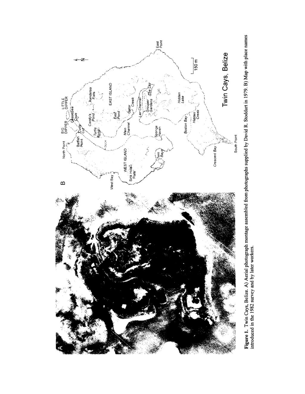
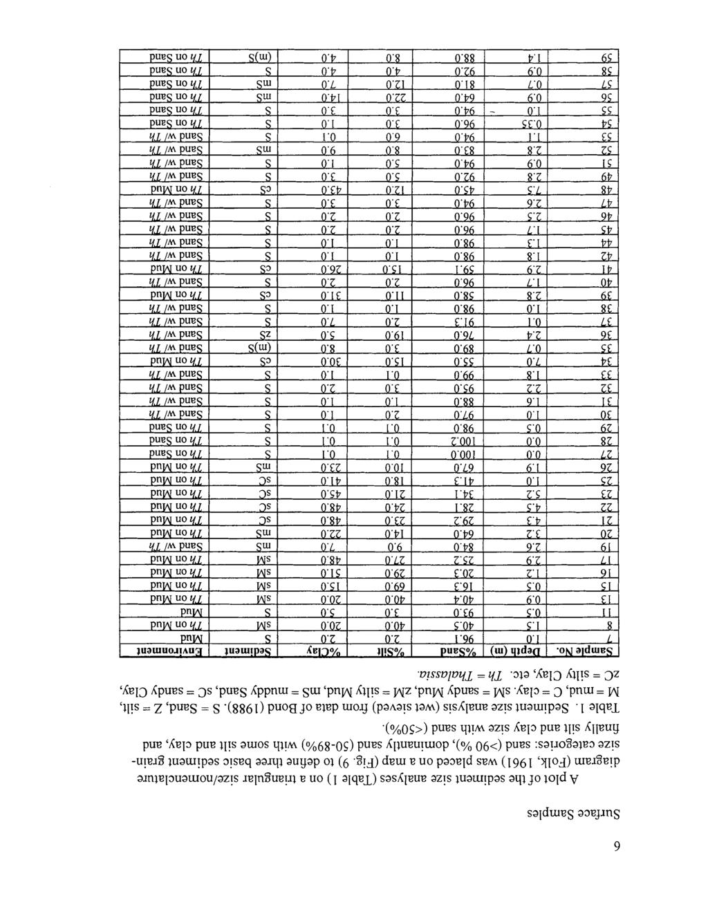
4 METHODS In 1982, I. G. Macintyre and W. T. Boykins mapped the major marine and subaerial surface depositional environments for Twin Cays and the surrounding area with the aid of aerial photographs (Fig. 1). During this mapping, a total of 120 surface sediment samples were collected (Fig. 2) from the marine environments. Size analyses were carried out in all but the very organic-rich samples collected in the channel areas. Samples were wetsieved at the Texas A&M Geosciences laboratory (mesh sizes 2 mm, 1 mm, 0.5 mm, 0.25 mm, mrn, and <0.063 mm) (Bond, 1988). The mud fractions were then sent to the Sedimentology Laboratory at Smithsonian Institution and separated into silt (63 rnrn - 4p) and clay (<4p) size fractions by decantation. Percentages for each size fraction were calculated for all samples (Table 1). Samples estimated to be composed of >5O% organics were not sieved. These have been omitted from Table 1. Twin Cays, Belize 085 Figure 2. Map of Twin Cays with numbered sediment sample locations.

5 Three thin sections, in the coarse, medium, and fine sand ranges, were made from a sediment sample representing each major marine depositional environments as determined in the field from aerial and boat-based reconnaissance. Thin sections were point-counted to a minimum of 320 points per slide. Loose grains of the very coarse sand and granule size distributions were also counted for these samples, with either the entire set of grains being counted or a subsarnple if more than 600 grains were present. RESULTS char2 (Fig. [ere In cover Mangroves Sparse mangroves No mangroves rn Mud Thalassia on mud Sand (blowout) Sand with Thalassia Thalassia on sand Figure 3. Depositional environments map of Twin Cays based on 1982 field observations.

6 Emergent Environments Mangrove cover consists of thick-to-moderate density of either mixed red and black mangroves or monospecific red mangroves along the outer margins of the islands, closest to water. Mangroves create an in situ peat substrate with leaf mats, which intertongue with carbonate sands at the shoreline. Sparse mangrove cover is found in shallow ponds and other interior portions of the islands. Scattered red mangrove development occurs in the ponds, while a mixture of red and black mangroves grows around the ponds and extends into interior regions. Sediment on pond bottoms consists of flocculated mud cover on a thick peat base, with scattered Halimeda sp. and Thalassia testudinum. The forest mat is a peat base with leaf litter layers and a mixture of remains of other succulent plants. Mangroveless environments occur near the large shallow pond in the interior of the island. The bottom is covered with a thin layer of flocculated mud over a peat base. Scattered molluscs occur as well as rare dwarf red mangrove trees. Submerged Environments The "Mud bottom" environment occurs in both the interior channels of Twin Cays and in the protected leeward lagoon near the island. Mud is described as "thixotropic" andfor flocculent. Patchy Thalassia testudinum, Halimeda and Penicillus occur on the mud bottom. Callianassid shrimp burrows and the upside-down jellyfish, Cassiopeia xamachana, are common (Fig. 4). Along channel shorelines, the mud bottom is replaced by a Halimeda sand bottom adjacent to mangrove prop roots surrounded by Halimeda mats. The oyster Crassotrea rhizophorae also commonly encrusts prop roots, giving rise to adjacent shell hash. Mangrove leaf mats cover some muddy areas. In the extremely restricted Lair Channel the mud bottom is very rich in organic content (Fig. 5). The "Thalassia on Mud" bottom environments consist of muddy or soft sand-mud bottoms with either a patchy or extensive Thalassia testudinum cover, both in open deeper (->3m) areas and in channels (Fig. 6). The Thalassia has longer blades, typical for deeper areas. Scattered Halimeda and Penicillus grow within the Thalassia areas. Caulerpa sp., Diadema and Callianassid shrimp burrows are common. This depositional environment has a wide depth range ( m; avg. 3.5 m). The "Thalassia on Sand" environment occurs on the windward side of Twin Cays and is characterized by a compact sandy or sandy mud bottom densely covered by Thalassia testudinum, with Syringodium jiliforme, Penicillus sp., Halimeda opuntia (forming large mounds), Diadema, other echinoids, Porites furcata and Callianassid shrimp mounds (Fig. 7). The sediments in some places contain shell hash layers or overlie a peat base. Sand blowouts are sandy depressions in these Thalassia beds that have been eroded during severe storm activity. Water depths range from 0.0 to 2.5 m (avg. 1.2 m). The "Sand with Thalassia" bottom is generally a shallow water ( m; avg. 1.7 m) environment (Fig. 8) trending E-W across the northern coast of Twin Cays. Smaller areas occur at South Point and in small shallow patches within the deeper "Thalassia

7 on Mud" environment on the leeward western side of the islands (Fig. 3). The bottom consists predominantly of hard, compact, rippled sand. Varying densities of the seagrasses Thalassia, Syringodium, and Halodule occur with the algae Halimeda opuntia, Penicillus, Laurencia and branching Neogoniolithon strictum. Corals include Manicina areolata, Porites divaricata, Porites furcata, Porites astreoides, Siderastrea radians, branching Cladocora arbuscula, and rare occurrences of Acropora cervicornis. Diadema are numerous as are Callianassid shrimp burrows. Other echinoids occur, as do gorgonians. Figure 4. "Mud bottom" depositional environment in north end of the channel separating the West and East Islands. Note scattered Halimeda and the upside-down jell yfish Cassiopeia xamachana (arrow). Figure 5. Organic-rich mud bottom of the Lair Channel. Figure 6. "Thalassia on Mud" depositional environment along the leeward (western) lagoonal side of West Island, Twin Cays. Note long Thalassia blades and Callianassid shrimp burrows (arrows) Figure 7. "Thalassia on Sand" depositional environment along the windward (eastern) shoreline of East Island, Twin Cays.
8

9 O S I Th on Sand ( I Mud
10 Twin Cays, Belize C z 2: 1 1 :2 c-i! clay C:Z silt (after Folk. 1961) s 0 sand > 90% cs-ms-zs 8 > SO-89%S SC-SM-sz < 50% sand Figure 9. Map showing the sediment grain-size size characteristics at each location based on Folk's (1961) nomenclature illustrating the percentage of sand for each sample. Compare to depositional environment map (Figure 3).
.")
11 Thin Sections Particle types that were point-counted included: Halimeda plates, bivalves, gastropods, miliolid foraminifera, soritid foraminifera, rotilid foraminifera, echinoderm fragments, coral fragments, coralline algae, crustacean fragments, tunicate spicules, alyconarian spicules, diatoms, fish teeth and quartz grains (Bond, 1988). Point count data (percentages of various grain types) of samples (33,34,48,63,72,94,96, 1 13) representing the depositional environments (Table 2) indicate that Halimeda is the dominant skeletal component in the thin sections forming the primary skeletal grain in the sand size range and in the granule class. Both bivalve and gastropod shell fragments are the next most abundant grain type, followed by foraminifera. The combined compositional percentages of Halimeda and molluscs correlate closely to the percent sand in the samples, except in two mud-dominated samples. Other constituent grains include, in the coarsest size fractions, molluscs, miliolid foraminifers and echinoderm fragments, with bivalves in certain cases being locally dominant. Foraminifera tend to be miliolids in the sand size fractions and in the finer grained fractions rotilid and soritid foraminifera become increasingly abundant. Echinoderm fragments form no more than three percent of any thin section point count. Table 2. Thin section point count data - sedimentary constituents (after Bond 1988). % Sand is from Table 1. The % Sand correlates to the total of % Halimeda + % Molluscs in all cases except samples 34 and 48, which are located in muddy areas and have higher percentages of molluscs, foraminifera and other components. Th = Thalassia. DISCUSSION AND CONCLUSIONS A total of three emergent mangrove and five marine depositional environments occur on and around Twin Cays (Fig. 3). In marine depositional environments surrounding Twin Cays, sediment analyses (Table 1) and depositional environments mapped in Figure 3 indicate a generally sand-dominated series of bottom types distinguished by their windward or leeward locations, water depths, and the density of aquatic vegetation. An extensive study of the distribution of submerged macroalgae and seagrasses at Twin Cays was conducted by Littler et al. (1985). The sheltered channels of Twin Cays apparently contained lower species diversity (dominated by productive filamentous algae) and greater total cover than the more exposed bay community, where Halimeda and Thalassia provided the dominant cover. Lower levels of physical
. Nearshore windward depositional environments (\"Thalassia on Sand,\" Fig.")
12 disturbance, lack of herbivory and greater availability of recycled nutrients in channels near mangroves account for the greater incidence of filamentous algae than in the waveexposed bay environments (Littler et al., 1985). Nearshore windward depositional environments ("Thalassia on Sand," Fig. 7) consist of sandier (Halimeda-rich) sediments with a denser cover of Thalassia testudinum than in leeward and offshore environments. The deeper windward offshore area is classified as "Thalassia on Mud" (Fig. 6), a depositional environment that extends into the main channel between East and West Islands, as well as across much of the western (leeward) shelf. Areas of "Sand with Thalassia" (Fig. 8) occur in patches on the western shelf, at South Point and along the northern edges of the islands. The "Sand with Thalassia" depositional environment contains a lower density of Thalassia than the "Thalassia on Sand" areas along the windward coast. The main muddy areas are limited to the W-E trending channel into the interior of East Island. Sediment samples 1-6 obtained from the inner reaches of this channel were judged to be too organic-rich for sediment analysis. A comparison of the sediment grain-size patterns in Figure 8 with the marine depositional environments map in Figure 3 indicates that the mud-rich areas are mostly limited to the low-energy sites in the Twin Cays channels and to the deeper "Thalassia on Mud" depositional environment. The muddy sands also tend to be found in more protected sites off the coasts and in the deeper "Thalassia on Sand" areas. Finally, the very sandy samples are generally limited to the shallow well-winnowed and compact bottoms of the "Sand with Thalassia" environment. The Halimeda sand-dominated sediments of the Twin Cays area are consistent with Purdy et al.'s (1 975) designation of a large Halimeda facies for this area of the Barrier Reef Platform lagoon. Our sediment analyses allowed us to differentiate Purdy et al.'s (1975) general Halimeda facies into the three distinct environments described above based on the percentage of sand (Fig. 9). The dominance of mud-size sediment in the protected channel areas has persisted for thousands of years as illustrated in the Holocene cross-sections in Macintyre et al. (this volume). The other muddy environment ("Thalassia on Mud"), consisting of mud with a rich cover of Thalassia, occurs in the deeper (2-7 m) areas of the windward coast, all through the central channel between the Islands, continuing outward along the bay side (Fig. 3). The sandy areas ("Sand with Thalassia;" "Thalassia on Sand"), directly adjacent to the shorelines, consist of shallow (0-4 m) flats of compact sand with scattered Thalassia. Again, the Holocene sections (Macintyre et al., this volume) indicate that over the 8,000 cal-year mangrove-peat history of Twin Cays, these lagoonal Halimeda-rich sands transgressed into the mangroves, sometimes for thousands of years. Halimeda dominated the sedimentation, while Rhizopora mangle formed peat and both maintained the buildup with sea-level rise over the Holocene. Along the north coast of Twin Cays, the "Sand with Thalassia" depositional environment meets a shoreline of eroding peat and mangroves, similar to the north coast of nearby Tobacco Range (Macintyre et al., 1995). This erosion is likely due to the destructive N-NE winter wave climate. In contrast, the windward southern and eastern shores consist of mangroves that are prograding over lagoonal sediments, as reflected in the elongate shape of Eastern Island and the lobes of sandy deposits surrounding South Point.
13 ACKNOWLEDGMENTS William T. Boykins is gratefully acknowledged for his assistance during the initial survey. We also thank Mary Parish for her help with graphics, and William Boykins for text and photographic layouts (CCRE Contribution Number 675). REFERENCES Bond, G.B Sedimentology and Holocene stratigraphy of a carbonate mangrove buildup, Twin Cays, Belize, Central America. Unpublished MSc thesis. Texas A&M University, College Station, Texas. 108p. Burke, R.B Reconnaissance study of the geomorphology and benthic communities of the outer Barrier reef Platform, Belize. In: Rutzler, K. and I.G. Macintyre, eds., The Atlantic Barrier Reef Ecosystem at Carrie Bow Cay, Belize 1, Smithsonian Contributions to the Marine Sciences No. 12: , Smithsonian Press, Washington, DC. Folk, R.L Petrology of Sedimentary Rocks. Austin Texas, Hemphill's 154p. Littler, M.M., P.R. Taylor, D.S. Littler, R.H. Sims, and J.N. Norris The distribution, abundance, and primary productivity of submerged macrophytes in a Belize barrier-reef mangrove system. Atoll Research Bulletin 289,20p. Macintyre, I.G., M.M. Littler, and D.S. Littler Holocene history of Tobacco Range, Belize, Central America. Atoll Research Bulletin 430, 18p. Macintyre, I.G., M.A. Toscano, R.G. Lighty, and G.B. Bond Holocene history of the mangrove islands of Twin Cays, Belize, Central America. Atoll Research Bulletin (this issue). Purdy, E.G., W.C. Pusey 111, and K.F. Wantland Continental shelf of Belize - regional shelf attributes. In: Wantland, K.F. and W.C. Pusey, eds., Belize Shelf- Carbonate Sediments, Clastic Sediments, and Ecology, American Association of Petroleum Geologists, Studies in Geology 2: 1-39.
14 Riitzler,K., and I.G. Macintyre The Atlantic Barrier Reef Ecosystem at Carrie Bow Cay, Belize, 1 Structure and Communities. Smithsonian Contributions to the Marine Sciences 12, 539p, Smithsonian Press, Washington, DC. Smith, F.G.W Atlantic Reef Corals. Miami, Florida. University of Miami Press 164 p.
MAINTENANCE DREDGE BENTHIC ASSESSMENT SUNSET POINT FARM LLC LONG POINT KEY MONROE COUNTY, FLORIDA. Prepared by:
 MAINTENANCE DREDGE BENTHIC ASSESSMENT SUNSET POINT FARM LLC LONG POINT KEY MONROE COUNTY, FLORIDA Prepared by: December 11, 2016 INTRODUCTION The owners of the Sunset Point Farms LLC, located on the northern
Holocene Carbonate-Siliciclastic Shoreline and Ravinement Stratigraphy of the Belize Lagoon: a Mixed-System Model
 Holocene CarbonateSiliciclastic Shoreline and Ravinement Stratigraphy of the Belize Lagoon: a MixedSystem Model DONALD F. MCNEILL AND CLINTON A. COWAN Key findings o Mixedsystem facies heterogeneity during
Brief report on Belize carbonate environments field trip Feb. 2012
 Brief report on Belize carbonate environments field trip Feb. 2012 In february 2012 I travelled to San Pedro (Ambergris Caye) Belize (Figure 1) to examine and study depositional environments of carbonate
Shelf Reefs, Southwestern Puerto Rico
 Shelf Reefs, Southwestern Puerto Rico Jack Morelock, Nahum Schneidermann, and W. R. Bryant Abstract The insular shelf off Parguera, Puerto Rico, is 8 to 10 km wide. The shelf break at 20 m depth is a marginal
Lecture Outline Wednesday - Friday February 14-16, 2018
 Lecture Outline Wednesday - Friday February 14-16, 2018 Quiz 2 scheduled for Friday Feb 23 (Interlude B, Chapters 6,7) Questions? Chapter 6 Pages of the Past: Sedimentary Rocks Key Points for today Be
CORAL BIODIVERSITY AND ZONATION ON A PLEISTOCENE REEF, SOUTHEASTERN JAMAICA
 CORAL BIODIVERSITY AND ZONATION ON A PLEISTOCENE REEF, SOUTHEASTERN JAMAICA Sherene A. James PhD Student - University of the West Indies, Mona Education Outreach Officer - Natural History Division, Institute
Holocene evolution of Dahab coastline Gulf of Aqaba, Sinai Peninsula, Egypt 1
 Holocene evolution of Dahab coastline Gulf of Aqaba, Sinai Peninsula, Egypt 1 Magdy Torab* 2 * Prof. of Geomorphology, Department of Geography, Damanhour University, Egypt 3 E-mail: magdytorab@hotmail.com.
Chapter 5. The Sedimentary Archives
 Chapter 5 The Sedimentary Archives Factors affecting Sedimentary Characteristics 1. Tectonic setting 2. Physical, chemical, and biological processes in the depositional environment 3. Method of sediment
Sedimentary Environments Chapter 8
 Sedimentary Environments Chapter 8 Does not contain complete lecture notes. To be used to help organize lecture notes and home/test studies. What is a sedimentary rock? Sedimentary rocks are products of
Paleo Lab #4 - Sedimentary Environments
 Paleo Lab #4 - Sedimentary Environments page - 1. CHARACTERISTICS OF SEDIMENT Grain size and grain shape: The sizes and shapes of sedimentary particles (grains) are modified considerably during their transportation
The Marine Environment
 The Marine Environment SECTION 16.1 Shoreline Features In your textbook, read about erosional landforms, beaches, estuaries, longshore currents, and rip currents. For each statement below, write or. 1.
Sediment. Weathering: mechanical and chemical decomposition and disintegration of rock and minerals at the surface
 Sediment Some basic terminology Weathering: mechanical and chemical decomposition and disintegration of rock and minerals at the surface Erosion: removal of weathered rock and minerals from one place to
Sediments and Sedimentary Rocks
 Sediments and Sedimentary Rocks (Shaping Earth s Surface, Part 2) Science 330 Summer 2005 What is a sedimentary rock? Products of mechanical and chemical weathering Account for about 5 percent of Earth
Feet. SAND; clayey, fine grained; shells are common; rounded quartz grains. SHELLS; muddy; almost no sand, shells and fragments common
 SAND; clayey, fine grained; shells are common; rounded quartz grains SHELLS; muddy; almost no sand, shells and fragments common SAND; back to medium to fine; has a mottled appearance and looks burrowed;
Laboratory#6 Sediment Particle Size Distribution and Turbidity Flows
 Laboratory#6 Sediment Particle Size Distribution and Turbidity Flows Although this laboratory will pertain to oceanic sediments similar processes can also be observed on land and other aquatic systems
ATOLL RESEARCH BULLETIN NO. 536
 ATOLL RESEARCH BULLETIN NO. 6 MEASUREMENTS OF THE GENERATION AND DISTRIBUTION OF CARBONATE SEDIMENTS OF BUCK ISLAND CHANNEL, ST. CROIX, U. S. VIRGIN ISLANDS, WITH OBSERVATIONS ABOUT SEDIMENTS IN FRINGING
DATA REPOSITORY MATERIAL: PALEOCHANNEL GROUP MAPPING DESCRIPTIONS
 Data Repository item 2695 DATA REPOSITORY MATERIAL: PALEOCHANNEL GROUP MAPPING DESCRIPTIONS Groups 1 (North Myrtle Beach) and 2 (Atlantic Beach) Channel Groups 1 (North Myrtle Beach) and 2 (Atlantic Beach)
Directed Reading. Section: The Water Planet. surface is called the a. Earth s ocean. b. Pacific Ocean. c. salt-water ocean. d. global ocean.
 Skills Worksheet Directed Reading Section: The Water Planet 1. The body of salt water covering nearly three-quarters of the Earth s surface is called the a. Earth s ocean. b. Pacific Ocean. c. salt-water
Significant Ecological Marine Area Assessment Sheet
 Significant Ecological arine Area Assessment Sheet Name: Eastern Bay of Island Biogenic Soft Sediment Complex Summary: The semi-sheltered areas between the central islands of the Eastern Bay of Islands
The Marine Environment
 The Marine Environment SECTION 16.1 Shoreline Features In your textbook, read about erosional landforms, beaches, estuaries, longshore currents, and rip currents. For each statement below, write true or
(with 3 Text-figures)
") 18 SUBTIDAL SEDIMENTARY FACIES, SOUTHERN MORETON BAY by M.C. Friederich (with 3 Text-figures) ABSTRACT. On the basis of the mud/sand and carbonate content, sediments are assigned to one of four facies:
18 SUBTIDAL SEDIMENTARY FACIES, SOUTHERN MORETON BAY by M.C. Friederich (with 3 Text-figures) ABSTRACT. On the basis of the mud/sand and carbonate content, sediments are assigned to one of four facies:
Sediment and sedimentary rocks Sediment
 Sediment and sedimentary rocks Sediment From sediments to sedimentary rocks (transportation, deposition, preservation and lithification) Types of sedimentary rocks (clastic, chemical and organic) Sedimentary
The Coast: Beaches and Shoreline Processes
 1 2 3 4 5 6 7 8 9 The Coast: es and Shoreline Processes Trujillo & Thurman, Chapter 10 Oceanography 101 Chapter Objectives Recognize the various landforms characteristic of beaches and coastal regions.
The Coast: Beaches and Shoreline Processes Trujillo & Thurman, Chapter 10
 The Coast: es and Shoreline Processes Trujillo & Thurman, Chapter 10 Oceanography 101 Chapter Objectives Recognize the various landforms characteristic of beaches and coastal regions. Identify seasonal
Lab 7: Sedimentary Structures
 Name: Lab 7: Sedimentary Structures Sedimentary rocks account for a negligibly small fraction of Earth s mass, yet they are commonly encountered because the processes that form them are ubiquitous in the
The Nature of Sedimentary Rocks
 The Nature of Sedimentary Rocks Sedimentary rocks are composed of: Fragments of other rocks Chemical precipitates Organic matter or biochemically produced materials The Nature of Sedimentary Rocks Sedimentary
EARTH SURFACE PROCESSES AND SEDIMENTATION!
 Sed and Strat EARTH SURFACE PROCESSES AND SEDIMENTATION! 2/27 Lecture 7- Exposure: Weathering and the Sediment Factory 3/04 Lecture 8 - Rivers and Landscapes 3/06 Lecture 9 - Waves (not Tides) 3/11 Lecture
What creates a coral reef? Why are corals able to form huge reefs?
 Marine ecosystems 5: Coral Reefs Unique features The foundation of the ecosystem is produced by living things Reef-building corals Similarities with tropical rain forests Richness and complexity 3-dimensional
THE PLEISTOCENE LIMESTONE FOUNDATION BELOW TWIN CAYS, BELIZE, CENTRAL AMERICA IAN G. MACINTYRE AND MARGUERITE A. TOSCANO
 ATOLL RESEARCH BULLETIN NO. 511 THE PLEISTOCENE LIMESTONE FOUNDATION BELOW TWIN CAYS, BELIZE, CENTRAL AMERICA BY IAN G. MACINTYRE AND MARGUERITE A. TOSCANO ISSUED BY NATIONAL MUSEUM OF NATURAL HISTORY
Sedimentary Rocks Chapter 6
 Sedimentary Rocks Chapter 6 I. What is a sedimentary rock? A. Sedimentary rock 1) Rock made of detrital sediments (such as sand) or inorganic/organic chemical precipitates (such as calcite) 2) Detrital
III. Acropora coral habitat distribution
 2008 Quick Look Report: Miller et al. III. Acropora coral habitat distribution Background The declines in abundance of two of the principal Caribbean reef-building corals, staghorn coral (Acropora cervicornis)
GEOLOGY MEDIA SUITE Chapter 5
 UNDERSTANDING EARTH, SIXTH EDITION GROTZINGER JORDAN GEOLOGY MEDIA SUITE Chapter 5 Sedimentation Rocks Formed by Surface Processes 2010 W.H. Freeman and Company Mineralogy of sandstones Key Figure 5.12
Environmental Science
 Environmental Science A Study of Interrelationships Cui Jiansheng Hebei University of Science and Technology CH06 Kinds of Ecosystems and Communities Chapter Objectives After reading this chapter, you
Earth / Environmental Science. Ch. 14 THE OCEAN FLOOR
 Earth / Environmental Science Ch. 14 THE OCEAN FLOOR The Blue Planet Nearly 70% of the Earth s surface is covered by the global ocean It was not until the 1800s that the ocean became an important focus
4. The map below shows a meandering stream. Points A, B, C, and D represent locations along the stream bottom.
 1. Sediment is deposited as a river enters a lake because the A) velocity of the river decreases B) force of gravity decreases C) volume of water increases D) slope of the river increases 2. Which diagram
Sediment and Sedimentary rock
 Sediment and Sedimentary rock Sediment: An accumulation of loose mineral grains, such as boulders, pebbles, sand, silt or mud, which are not cemented together. Mechanical and chemical weathering produces
Small area of the ocean that is partially surrounded by land. The Ocean Basins. Three Major Oceans. Three Major Oceans. What is a SEA?
 The Ocean Basins How Deep is the Ocean? 1 2 Three Major Oceans Three Major Oceans Pacific Atlantic the shallowest ocean (3.3km average depth) Indian second shallowest ocean (3.8km average depth) Pacific
The boundary between two formations (or any distinct layers) is called a contact. Sedimentary rocks cover 75% of continents.
 is called a contact. Sedimentary rocks cover 75% of continents.") Sedimentary Rocks Sedimentary rocks form at the Earth s surface through interactions of the hydrologic system and the crust. Fortunately, many of these processes are in operation today, and geologists
Sedimentary Rocks Sedimentary rocks form at the Earth s surface through interactions of the hydrologic system and the crust. Fortunately, many of these processes are in operation today, and geologists
"The Relationship Between Seagrass Cover and Species- richness of Invertebrates"
 "The Relationship Between Seagrass Cover and Species- richness of Invertebrates" SCIE 2204: Marine Systems The Cottesloe Marine Ecosystem Research Project 2014 By Baronie Shaw, K., Bortoloso, T., Cargill,
What Are Coral Reefs?
 ELA.08.CR.1.9.132 C1 T9 Sample Item Id: ELA.08.CR.1.9.132 Grade/Model: 08 / 1b Claim: 1: Students can read closely and analytically to comprehend a range of increasingly complex literary and informational
GY 402: Sedimentary Petrology
 UNIVERSITY OF SOUTH ALABAMA GY 402: Sedimentary Petrology Lecture 22: Reefs Instructor: Dr. Douglas W. Haywick Last Time Shelves Definition and a bit of history Factors controlling shelf sedimentation
Marine Sediments EPSS15 Spring 2017 Lab 4
 Marine Sediments EPSS15 Spring 2017 Lab 4 Why Sediments? Record of Earth s history - Tectonic plate movement - Past changes in climate - Ancient ocean circulation currents - Cataclysmic events 1 Classification
GLY Coastal Geomorphology Notes
 GLY 4734 - Coastal Geomorphology Notes Dr. Peter N. Adams Spring 2011 2 Coastal Classification In this lecture, we discuss some successful classification schemes of the coastal landscape, and pay particular
Unit 4 - Water. Earth s Interior. Earth s Interior. Continental Drift. Continental Drift. Continental Drift. Crust. Mantle. Core.
 Unit 4 - Water How did the oceans form? What special adaptations do saltwater organisms have? Where does our water come from? How do humans affect the Earth s water? Crust Rigid outer shell of Earth Oceanic
Coastal and Marine Ecological Classification Standard (CMECS)
") Coastal and Marine Ecological Classification Standard (CMECS) Kathy Goodin, NatureServe EMECS, August 2011 Baltimore, MD 1 Outline Objectives & Process Classification Content Questions 2 Objectives Develop
Coastal and Marine Ecological Classification Standard (CMECS) Kathy Goodin, NatureServe EMECS, August 2011 Baltimore, MD 1 Outline Objectives & Process Classification Content Questions 2 Objectives Develop
Types of intertidal communities
 Between the tides Marine ecosystems 1 Intertidal Delimited by the highest high tide and the lowest low tides marks The best studied and best-understood by humans Relatively easy to sample compared to other
Nearshore Benthic Habitats Program
 Nearshore Benthic Habitats Program Travis Thyberg, Diego Lirman, Greg Deangelo, Joe Serafy, Sarah Bellmund, Ligia Collado, Joan Browder Rosenstiel School of Marine & Atmospheric Science University of Miami
Bulletin of Earth Sciences of Thailand
 Depositional Environments and Stratigraphic Development of the Grand Taman Sari Circuit Outcrop: an Analogue for Transgressive Mahakam Delta Successions Ridha Santika Riadi Petroleum Geoscience Program,
Kigoma Bay bathymetry, sediment distribution, and acoustic mapping
 Kigoma Bay bathymetry, sediment distribution, and acoustic mapping Student: Gwynneth Smith Mentor: Kiram Lezzar Introduction Echosounding is a method commonly employed for determining the bathymetry of
ARE YOU READY TO THINK? Look at the first slide THINK PAIR SHARE!
 ARE YOU READY TO THINK? Look at the first slide THINK PAIR SHARE! WHAT PROMINENT FEATURE CAN YOU IDENTIFY IN THIS PICTURE? What do you think the different colors represent? Who might find such a picture
The Ocean Floor Chapter 14. Essentials of Geology, 8e. Stan Hatfield and Ken Pinzke Southwestern Illinois College
 The Ocean Floor Chapter 14 Essentials of Geology, 8e Stan Hatfield and Ken Pinzke Southwestern Illinois College The vast world ocean Earth is often referred to as the water planet 71% of Earth s surface
EPS 50 Lab 4: Sedimentary Rocks
 Name: EPS 50 Lab 4: Sedimentary Rocks Grotzinger and Jordan, Chapter 5 Introduction In this lab we will classify sedimentary rocks and investigate the relationship between environmental conditions and
Sedimentology, Petrography, and Mineralogy of the Tallahatta Formation near the City of Meridian, Mississippi
 Sedimentology, Petrography, and Mineralogy of the Tallahatta Formation near the City of Meridian, Mississippi Kiana McFadden and Ezat Heydari Department of Physics, Atmospheric Sciences, and Geoscience,
ENGINEERING WITH NATURE: NEARSHORE BERM PLACEMENTS AT FORT MYERS BEACH AND PERDIDO KEY, FLORIDA, USA
 1 ENGINEERING WITH NATURE: NEARSHORE BERM PLACEMENTS AT FORT MYERS BEACH AND PERDIDO KEY, FLORIDA, USA KATHERINE E. BRUTSCHÉ 1, PING WANG 2, JULIE D. ROSATI 1, CHERYL E. POLLOCK 1 1. U.S. Army Engineer
Sedimentary Rocks. Origin, Properties and Identification. Physical Geology GEOL 101 Lab Ray Rector - Instructor
 Sedimentary Rocks Origin, Properties and Identification Physical Geology GEOL 101 Lab Ray Rector - Instructor Sedimentary Rock Origin and Identification Lab Pre-Lab Internet Link Resources 1) http://www.rockhounds.com/rockshop/rockkey/index.html
Depositional Environment
 Depositional Environment Sedimentary depositional environment describes the combination of physical, chemical and biological processes associated with the deposition of a particular type of sediment. Types
Facies Analysis Of The Reservoir Rocks In The. Sylhet Trough, Bangladesh. Abstract
 Facies Analysis Of The Reservoir Rocks In The Sylhet Trough, Bangladesh Joyanta Dutta Petroleum Geoscience Program, Department of Geology, Faculty of Science, Chulalongkorn University, Bangkok 10330, Thailand
Skeletal grains. Pores. Matrix <20 m) Cement. Non-skeletal grains. 1 cm
 Cement. Non-skeletal grains. 1 cm") Components of a Carbonate rock Skeletal grains Pores Matrix
Components of a Carbonate rock Skeletal grains Pores Matrix
Marine Sediments. Introductory Oceanography. Ray Rector: Instructor
 Marine Sediments Introductory Oceanography Ray Rector: Instructor Ocean Basins are Vast Sinks for Huge Amounts of Sediment from Numerous Different Sources Four Major Types of Seafloor Sediments 1. Lithogenous
24. Ocean Basins p
 24. Ocean Basins p. 350-372 Background The majority of the planet is covered by ocean- about %. So the majority of the Earth s crust is. This crust is hidden from view beneath the water so it is not as
GEOLOGIC MAPS OF THE SOUTHWESTERN PUERTO RICO PARGUERA TO GUANICA INSULAR SHELF
 GEOLOGIC MAPS OF THE SOUTHWESTERN PUERTO RICO PARGUERA TO GUANICA INSULAR SHELF Jack Morelock, Elizabeth A. Winget, and Carlos Goenaga Introduction These maps describe the sediments and sedimentary environment
Weathering of Rocks. Weathering - Breakdown of rocks into pieces (sediment) 2 main types of weathering to rocks
 2 main types of weathering to rocks") Weathering of Rocks Weathering - Breakdown of rocks into pieces (sediment) 2 main types of weathering to rocks Mechanical weathering requires physical forces to break rocks into smaller pieces. Chemical
Weathering of Rocks Weathering - Breakdown of rocks into pieces (sediment) 2 main types of weathering to rocks Mechanical weathering requires physical forces to break rocks into smaller pieces. Chemical
Forecast of Nearshore Wave Parameters Using MIKE-21 Spectral Wave Model
 Forecast of Nearshore Wave Parameters Using MIKE-21 Spectral Wave Model Felix Jose 1 and Gregory W. Stone 2 1 Coastal Studies Institute, Louisiana State University, Baton Rouge, LA 70803 2 Coastal Studies
1 Shoreline Erosion and Deposition
 CHAPTER 12 1 Shoreline Erosion and Deposition SECTION Agents of Erosion and Deposition BEFORE YOU READ After you read this section, you should be able to answer these questions: What is a shoreline? How
2.2.7 Backbarrier flats
 FIGURE 24. VERTICAL PHOTOGRAPH SHOWING THE DEVELOPMENT OF SMALL PARABOLIC DUNES FROM BLOWOUTS IN A LARGE RELICT FOREDUNE NORTHWEST OF HUNTER'S CREEK. PHOTOGRAPH COURTESY OF CAR'T'ER HOLT HARVEY FORESTS
Sedimentary Rocks. Origin, Properties and Identification. Geology Laboratory GEOL 101 Lab Ray Rector - Instructor
 Sedimentary Rocks Origin, Properties and Identification Geology Laboratory GEOL 101 Lab Ray Rector - Instructor Sedimentary Rock Origin and Identification Lab Pre-Lab Internet Link Resources 1) http://www.rockhounds.com/rockshop/rockkey/index.html
Sedimentology & Stratigraphy. Thanks to Rob Viens for slides
 Sedimentology & Stratigraphy Thanks to Rob Viens for slides Sedimentology The study of the processes that erode, transport and deposit sediments Sedimentary Petrology The study of the characteristics and
The Geology of Sebago Lake State Park
 Maine Geologic Facts and Localities September, 2002 43 55 17.46 N, 70 34 13.07 W Text by Robert Johnston, Department of Agriculture, Conservation & Forestry 1 Map by Robert Johnston Introduction Sebago
MARINE GEOLOGY & GEOGRAPHY
 MARINE GEOLOGY MARINE GEOLOGY & GEOGRAPHY Marine Geology 4 LAYERS OF THE EARTH CRUST THICKNESS: VARIES BETWEEN OCEAN & CONTINENTS 5-40 KM STATE: SOLID ELEMENTS: SILICON, ALUMINUM, CALCIUM, SODIUM, POTASSIUM
Illustrations of Selected Ordovician fossils
 Illustrations of Selected Ordovician fossils Appendix 1 Brachiopods Cephalopods Brachiopods (brack'-i-oh-pods) are a group of marine animals with two shells. They all have an upper and lower shell. The
Sedimentary and Stratigraphic Analysis of the Viking Sand in the Edgerton/Wainwright Area, Central Alberta* By Russell Walz 1
 Sedimentary and Stratigraphic Analysis of the Viking Sand in the Edgerton/Wainwright Area, Central Alberta* By Russell Walz 1 Search and Discovery Article #50030 (2006) Posted June 25, 2006 *Extended abstract
Determination of texture characteristics of coastal sediments in East of Bandar Abbas
 Journal of Biodiversity and Environmental Sciences (JBES) ISSN: 2220-6663 (Print) 2222-3045 (Online) Vol. 6, No. 6, p. 515-520, 2015 http://www.innspub.net RESEARCH PAPER OPEN ACCESS Determination of texture
Maine Geologic Facts and Localities October, Lobster Lake, Maine. Text by Robert G. Marvinney. Maine Geological Survey
 Maine Geologic Facts and Localities October, 1998 Lobster Lake, Maine 45 o 51 7.91 N, 69 o 30 53.88 W Text by Robert G. Marvinney, Department of Agriculture, Conservation & Forestry 1 Map by Introduction
Understanding Earth Fifth Edition
 Understanding Earth Fifth Edition Grotzinger Jordan Press Siever Chapter 5: SEDIMENTATION: Rocks Formed by Surface Processes Lecturer: H Mohammadzadeh Assistant professors, Department of Geology, FUM Copyright
Module 9 Sedimentary Rocks
 Module 9 Sedimentary Rocks SEDIMENTARY ROCKS Rocks formed from material derived from preexisting rocks by surfacial processes followed by diagenesis There are two main classes of sedimentary rocks Clastic
Developed in Consultation with Florida Educators
 Developed in Consultation with Florida Educators Table of Contents Next Generation Sunshine State Standards Correlation Chart... 7 Benchmarks Chapter 1 The Practice of Science...................... 11
General Information about Tampa Bay
 General Information about Tampa Bay 400 square miles Watershed is 6 times that size Over 100 + tributaries Phytoplankton is the primary producer More than 200 fish species Five counties: Pasco, Polk, Pinellas,
7(i). Ripple patches in the Cretaceous Dakota Sandstone near Denver, Colorado, a classical locality for microbially bound tidal sand flats
. Ripple patches in the Cretaceous Dakota Sandstone near Denver, Colorado, a classical locality for microbially bound tidal sand flats") 1 7(i). Ripple patches in the Cretaceous Dakota Sandstone near Denver, Colorado, a classical locality for microbially bound tidal sand flats J. Schieber The Dakota Sandstone marks the Early Cretaceous
1 7(i). Ripple patches in the Cretaceous Dakota Sandstone near Denver, Colorado, a classical locality for microbially bound tidal sand flats J. Schieber The Dakota Sandstone marks the Early Cretaceous
Beach Pebbles Tell a Story
 Maine Geologic Facts and Localities September, 2000 Text by Joseph T. Kelley, Department of Agriculture, Conservation & Forestry 1 Introduction The smooth, sandy beaches of southern Maine are popular with
2013 SCEC Annual Report
 2013 SCEC Annual Report Collaborative research: Documentation of Tsunami Deposits in the Carpinteria Estuary: A signal of Great Earthquakes on the Pitas Point Thrust L. Reynolds, A. Simms, T.K. Rockwell,
14.2 Ocean Floor Features Mapping the Ocean Floor
 14.2 Ocean Floor Features Mapping the Ocean Floor The ocean floor regions are the continental margins, the ocean basin floor, and the mid-ocean ridge. 14.2 Ocean Floor Features Continental Margins A continental
II Why study coastal landforms?
 COASTAL LANDFORMS (32) I Main topics A Why study coastal landforms? B Sediment budget and system response C Coastal landforms 3/26/15 GG454 1 II Why study coastal landforms? A Dynamic systems B Reflect
To get you thinking Explain how these different layers of rock formed? Why are these layers different colors? Sedimentary Rocks
 To get you thinking Explain how these different layers of rock formed? Why are these layers different colors? Sedimentary Rocks Bryce Canyon, Utah Badlands, South Dakota Weathering Whenever rock is exposed
4 Sedimentary phosphate deposits 4.1 Introduction
 4 Sedimentary phosphate deposits 4.1 Introduction Sedimentary phosphate deposits or phosphorites contain few percents of calcium phosphate in form of grains of apatite, bone fragments or coprolites, and
Submersible investigation of unconfirmed western Miami Terrace habitat
 Submersible investigation of unconfirmed western Miami Terrace habitat Prepared By: Brian K. Walker, Ph.D. Nova Southeastern University Oceanographic Center 6/08/2015 On June 5, 2015 Nova Southeastern
MARINE GEOLOGY & GEOGRAPHY
 MARINE GEOLOGY & GEOGRAPHY Bathymetry BATHYMETRY BATHYMETRY THE UNDERWATER EQUIVALENT TO TOPOGRAPHY THE STUDY OF WATER DEPTH A BATHYMETRIC MAP SHOWS FLOOR RELIEF OR TERRAIN AS CONTOUR LINES Bathymetry
Ecoregions Glossary. 7.8B: Changes To Texas Land Earth and Space
 Ecoregions Glossary Ecoregions The term ecoregions was developed by combining the terms ecology and region. Ecology is the study of the interrelationship of organisms and their environments. The term,
CHAPTER 1 INTRODUCTION
 1 CHAPTER 1 INTRODUCTION 1.1 GENERAL Washover sandsheets are often found in low-lying coastal embayment s (Sedgwick and Davis 2003). Washover deposition of marine sand is usually attributed to storm activity
Late Holocene island reef development on the inner zone of the northern Great Barrier Reef: Insights from Low Isles Reef
 University of Nebraska - Lincoln DigitalCommons@University of Nebraska - Lincoln Papers in the Earth and Atmospheric Sciences Earth and Atmospheric Sciences, Department of 2008 Late Holocene island reef
Coral Reefs. Organisms and Ecology
 Coral Reefs Organisms and Ecology General Characteristics: Rival tropical rainforests for beauty, richness, complexity Basic structure is made by organisms 3 Dimensional framework home to incredible assortment
Oceanography. Oceanography is the study of the deep sea and shallow coastal oceans.
 Oceanography Oceanography is the study of the deep sea and shallow coastal oceans. Studying the Ocean Floor To determine the shape and composition of the ocean floor, scientists use techniques such as
Relatively little hard substrate occurs naturally in the
 CHAPTER FIVE Rock Habitats Relatively little hard substrate occurs naturally in the estuary, owing mainly to the vast quantities of fine sediment that have been deposited by the rivers. Rock habitat is
Permafrost-influenced Geomorphic Processes
 Section 4 Permafrost-influenced Geomorphic Processes Geomorphic processes vary greatly among ecoregions in northern Alaska, extending from the Beaufort Sea coast to the Brooks Range (Figure 4.1). Regional
THE DEPOSITS OF TSUNAMIS WESLEY PESANTEZ, CATHERINE NIELD, COLIN WINTER
 THE DEPOSITS OF TSUNAMIS WESLEY PESANTEZ, CATHERINE NIELD, COLIN WINTER AN OVERVIEW OF OUR SEMINAR WHAT IS A TSUNAMI WHY STUDY TSUNAMIS PROPERTIES OF TSUNAMIS TSUNAMI HYDRODYNAMICS IDEALIZED DEPOSITS SEDIMENT
Sedimentary Rocks. Origin, Properties and Identification. Physical Geology GEOL 100. Ray Rector - Instructor
 Sedimentary Rocks Origin, Properties and Identification Physical Geology GEOL 100 Ray Rector - Instructor Sedimentary Rock Origin and Identification Lab Pre-Lab Internet Link Resources 1) http://www.rockhounds.com/rockshop/rockkey/index.html
Sand. Sand is any eroded material (igneous, metamorphic or sedimentary) that has a grain size from 1/16 th to 2 millimeters in size.
 that has a grain size from 1/16 th to 2 millimeters in size.") Sedimentology 001 What is sedimentology? Sedimentology...encompasses the study of modern sediments such as sand [1], mud (silt) [2] andclay [3] and understanding the processes that deposit them.[4] It
Sedimentology 001 What is sedimentology? Sedimentology...encompasses the study of modern sediments such as sand [1], mud (silt) [2] andclay [3] and understanding the processes that deposit them.[4] It
Chapter 02 The Sea Floor
 Chapter 02 The Sea Floor Multiple Choice Questions 1. One of the following is not one of the world's major ocean basins: A. Atlantic Ocean B. Arctic Ocean C. Indian Ocean D. Antarctic Ocean E. Pacific
A BEACH IS A BEACH. Or Is It? Hawaii. St. Croix, US Virgin Islands
 A BEACH IS A BEACH Or Is It? Pt. Reyes, California Western Florida Hawaii AGI What is a beach? Eastern Maine A beach is a strip of shoreline washed by waves and tides. Crane Key, Florida Bay St. Croix,
Overview of Chapter 6
 Overview of Chapter 6 Earth s Major Biomes Aquatic Ecosystems Freshwater ecosystems Estuaries Marine Ecosystems Wildfires and Ecosystems Wildfire unexpected fire in grass, shrub, or forests (a significant
Chapter 17. Ocean and Coastal Processes
 Chapter 17 Ocean and Coastal Processes Ocean Basins and Plates Ocean Basins Ocean Basins are profoundly different from the continents. Ocean crust is thin and dense and young. New ocean crust is generated