Mission Pre-Briefing for Crew B
|
|
|
- Eleanore Martin
- 6 years ago
- Views:
Transcription
1 BPLF Lunar Mission Simulations 2009 Briefing Topic: Mission Pre-Briefing for Crew B


2 Regional Geologic Context Black Point Lava Flow 2009 Test Site BPLF occurs along the NE margin of a large volcanic field USGS DEM
3 Regional Geologic Context Morphology of an eroded stratovolcano
4 Regional Geologic Context Morphologies of cinder cones
5 Regional Geologic Context Morphologies of lava flows
6 Regional Geologic Context

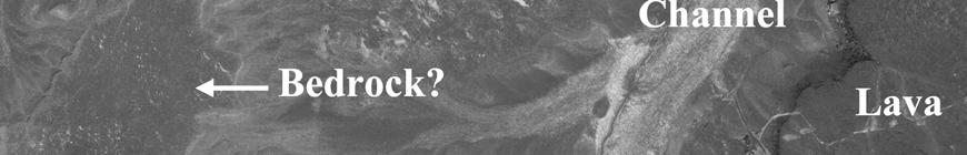
7 Black Point Lava Flow Black Point Lava Flow QuickBird Detail
8 Volcanic Terrain Additional Lava Flow Black Point Lava Flow Possible Volcanic Vents QuickBird Detail
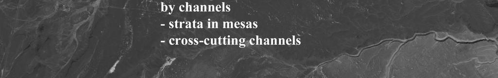
9 Underlying Layered Terrain Dark Albedo Layered Terrain Light Albedo Layered Terrain Black Point Lava Flow Light Albedo Layered Terrain a. Strata in mesas b. Strata in ravines c. Strata parallel to structural elements
10 Regional Slope Regional Slope Drains Towards River QuickBird Detail
11 Structural Elements Lineations & Anticlinal Fold QuickBird Detail
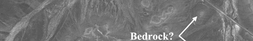
12 Geologic Units Volcanics Black Point Lava Flow Neighboring lava flows (up to seven within QuickBird frame) Potential vents (with cinder cones abundant beyond the limits of the QuickBird frame) Layered Terrain Strata with a wide range of albedos Surfaces with distinctly different knobby, lineated, & smooth surfaces Structurally modified (potential faults and fold) Cross-cutting Channels Localized High-albedo Terrain
13 Science Questions Are the Ages, Mineralogy, and Composition of these Lavas the Same? a. Strata in mesas b. Strata in ravines c. Strata parallel to structural elements
14 Science Questions Are these different lobes the same lava flow or different, overlapping lava flows?
15 Science Questions Are these different lobes the same lava flow or different, overlapping lava flows? Are there lateral or vertical variations In the lava flow(s)?
16 Science Questions What are the layered units? Sedimentary strata or volcanoclastic units? -Do these units extend the volcanic history of the area? - Or provide clues for past climates and ecosystems?
17 Science Questions What are the layered units? Sedimenatary strata or volcanoclastic units? What is responsible for albedo differences between regions and within each terrain?
18 Science Questions On the Moon We will be looking for paleoreogliths beneath lava flows. Is there a paleosol beneath this lava flow?
19 Science Questions On the Moon We will be looking for paleoreogliths beneath lava flows. Is there a paleosol beneath this lava flow? In general, the contacts between geologic units are very important.
20 Science Objectives Top-level objectives Determine the origin (nature) and relative ages of geologic units to determine the geologic history of the site Locate and collect suitable samples that will further elucidate these issues when analyzed in a terrestrial laboratory Specific test site objectives Characterize the Black Point Lava Flow (age, morphology, flow structure, petrology, chemistry, and any spatial or temporal variations) Determine the relationship of BPLF with other volcanic features in the area Characterize other geologic units in the area Characterize the structural evolution of the area
21 Science Objectives BPLF and other volcanic rocks Provide precise ages that are calibration points for the geologic history of a planet Provide information about the thermal evolution and interior chemistry of a planet Ideal targets for sample return missions, because a lot of additional information can be gleaned from them using terrestrial laboratories Thus, the highest priority sequence of rocks Layered, channel, and high-albedo units Layered rocks may be either volcaniclastic (in which case they might extend story gleaned from BPLF) or sedimentary (in which case they might provide information about past environments and climate) Channel deposits may provide mobilized debris from far-away terrains (although of limited value in this particular setting) High-albedo units are likely tertiary and unconsolidated sediments Although geologic important units, they are of lower science priority (particularly when viewed in a lunar analogue context) Structural elements Features that were not evident within the 2008 test area Rely more heavily on observational techniques rather than sample collection Provides an anologue to structural elements on the Moon (e.g., fault bounded blocks around the peripheries of impact craters or the folding that occurs in crater peaks and rims)
22 Science Objectives BPLF and other volcanic rocks Special Note: Although there are multiple flows in the test area, the only bedrock samples available on the north traverse will be from the BPLF. Samples of other flows will be limited to alluvial and eolian sedimentary deposits. Other volcanic rocks will, however, be accessible to traverses on the south and west sides of BPLF and should be a primary target during those traverses. Layered, channel, and high-albedo units Special Note: These units are well-exposed on the north side of BPLF. Some overlapping observations and collecting of these units may also be possible by traverses on the south and west sides of BPLF. Structural elements Special Note: Structural elements may be best exposed and accessible on a traverse along the north side of BPLF. A smaller number of features will be accessible on top of the flow (and all of them visible in the distance from the top of the flow). A subset of the structural elements may also be accessible on a traverse on the south side of the flow, if crew is able to reach the far southeastern corner of the test area.
23 Images with Additional Geologic Details
24 Black Point Lava Flow, Arizona


25 Black Point Lava Flow, Arizona
26 Black Point Lava Flow, Arizona
27 Black Point Lava Flow, Arizona
28 Black Point Lava Flow, Arizona

29 Black Point Lava Flow, Arizona


30 Black Point Lava Flow, Arizona


31 Black Point Lava Flow, Arizona

32 Black Point Lava Flow, Arizona
33 Black Point Lava Flow, Arizona Does alluvium contain cobbles, pebbles, sand, and silt from lithologies far to the south of traverse region? Can sediment be used to determine the geology of those distant sites?
34 Black Point Lava Flow, Arizona What are lineations? - exposed strata? -joints? - dissolution fissures?

35 Black Point Lava Flow, Arizona
36 Black Point Lava Flow, Arizona Structural element: Offset stream channel
37 Black Point Lava Flow, Arizona Structural element: Offset stream channel ~1 km Scale of feature is 0.5 to 1 km ~0.5 km


38 Black Point Lava Flow, Arizona


39 Black Point Lava Flow, Arizona
40 Black Point Lava Flow, Arizona Preferred model - consistent with extension in area - consistent with distinct lithological window


41 Relative Distances QuickBird Detail
Lunar Exploration Initiative
 Briefing Topic: Expanding BPLF Activity to the West David A. Kring November 2008 Contents: Regional Geologic Context 2 Location of Desert RATS 2008-2009 Activities 10 Potential Expansion of Test Area to
Analogue Mission Simulations
 Analogue Mission Simulations Briefing Topic: Potential Locations for NEO Mission Simulations, Black Point Lava Flow, Arizona David A. Kring Analogue Mission Simulations Contents: Previous BPLF Mission
Examining the Terrestrial Planets (Chapter 20)
") GEOLOGY 306 Laboratory Instructor: TERRY J. BOROUGHS NAME: Examining the Terrestrial Planets (Chapter 20) For this assignment you will require: a calculator, colored pencils, a metric ruler, and your geology
GEOLOGY 306 Laboratory Instructor: TERRY J. BOROUGHS NAME: Examining the Terrestrial Planets (Chapter 20) For this assignment you will require: a calculator, colored pencils, a metric ruler, and your geology
COSMORPHOLOGY - May 2009
 Name COSMORPHOLOGY - May 2009 Geologic landforms Purpose: By studying aerial photographs you will learn to identify different kinds of geologic features based on their different morphologies and learn
Geologic Landforms Seen on Aerial Photos Instructor Notes
 1.5 hours Exercise Two Geologic Landforms Instructor Notes Suggested Correlation of Topics Geomorphology, gradation, impact cratering, tectonism, volcanism, photography Purpose The objective of this exercise
Starting at Rock Bottom
 Starting at Rock Bottom At rock bottom of the Brushy Creek site s geological column lies the first clue to human habitation: A smelting and heattreating furnace, and mold, carved into Bed Ked: Figure 15
Rilles Lunar Rilles are long, narrow, depressions formed by lava flows, resembling channels.
 Rilles Lunar Rilles are long, narrow, depressions formed by lava flows, resembling channels. Rugged Terra Rugged terra are mountainous regions of the moon. Wrinkle Ridges Wrinkle Ridges are created through
EPS 50 Lab 6: Maps Topography, geologic structures and relative age determinations
 Name: EPS 50 Lab 6: Maps Topography, geologic structures and relative age determinations Introduction: Maps are some of the most interesting and informative printed documents available. We are familiar
3. GEOLOGY. 3.1 Introduction. 3.2 Results and Discussion Regional Geology Surficial Geology Mine Study Area
 3. GEOLOGY 3.1 Introduction This chapter discusses the baseline study of the geology and mineralization characteristics of the mine study area. The study consolidates existing geological data and exploration
Science Targets Along a Proposed Gale Traverse. Ryan Anderson, Dawn Sumner & Jim Bell 5 th Mars Science Laboratory Landing Site Workshop May 17, 2011
 Science Targets Along a Proposed Gale Traverse Ryan Anderson, Dawn Sumner & Jim Bell 5 th Mars Science Laboratory Landing Site Workshop May 17, 2011 Traverse Overview This is a notional traverse. Based
Photogeologic Mapping of Mars
 Exercise Two and Fifteen are suggested as introductory exercises. 2.0 hours Exercise Seventeen Photogeologic Mapping of Mars Instructor Notes Suggested Correlation of Topics Deductive reasoning, geologic
Lunar Geology of Apollo 11 Landing Site. Chenango Forks High School Sharon Hartzell Sarah Maximowicz Benjamin Daniels Sarah Andrus Jackson Haskell
 Lunar Geology of Apollo 11 Landing Site Chenango Forks High School Sharon Hartzell Sarah Maximowicz Benjamin Daniels Sarah Andrus Jackson Haskell Lunar Maria Lunar Maria Lunar Maria Low albedo Volcanic
GLY 155 Introduction to Physical Geology, W. Altermann. Press & Siever, compressive forces. Compressive forces cause folding and faulting.
 Press & Siever, 1995 compressive forces Compressive forces cause folding and faulting. faults 1 Uplift is followed by erosion, which creates new horizontal surface. lava flows Volcanic eruptions cover
Figure 1 The map shows the top view of a meandering stream as it enters a lake. At which points along the stream are erosion and deposition dominant?
 1. In which type of climate does chemical weathering usually occur most rapidly? 1. hot and dry 3. cold and dry 2. hot and wet 4. cold and wet 2. Figure 1 The map shows the top view of a meandering stream
Name. 4. The diagram below shows a soil profile formed in an area of granite bedrock. Four different soil horizons, A, B, C, and D, are shown.
 Name 1. In the cross section of the hill shown below, which rock units are probably most resistant to weathering? 4. The diagram below shows a soil profile formed in an area of granite bedrock. Four different
Gale Crater MSL Candidate Landing Site in Context
 Gale Crater MSL Candidate Landing Site in Context by K. Edgett April 2010 MSL Science Team Landing Sites Discussions Gale Crater Edgett, p. 1 What do I mean by Context? How will the things we can learn
Geomorphology Final Exam Study Guide
 Geomorphology Final Exam Study Guide Geologic Structures STRUCTURAL GEOLOGY concerned with shapes, arrangement, interrelationships of bedrock units & endogenic (within) forces that cause them. Tectonic
Geology 101 Lab Worksheet: Geologic Structures
 Name: Geology 101 Lab Worksheet: Geologic Structures Refer to the Geologic Structures Lab for the information you need to complete this worksheet (http://commons.wvc.edu/rdawes/g101ocl/labs/structurelab.html).
Continental Landscapes
 Continental Landscapes Landscape influenced by tectonics, climate & differential weathering Most landforms developed within the last 2 million years System moves toward an equilibrium Continental Landscapes
Introduction. Background
 Introduction In introducing our research on mars we have asked the question: Is there a correlation between the width of an impact crater and the depth of that crater? This will lead to answering the question:
Directed Reading page
 Skills Worksheet Directed Reading page 185-190 Section: Determining Relative Age 1. How old is Earth estimated to be? 2. Who originated the idea that Earth is billions of years old? 3. On what did the
Structural Geology Lab. The Objectives are to gain experience
 Geology 2 Structural Geology Lab The Objectives are to gain experience 1. Drawing cross sections from information given on geologic maps. 2. Recognizing folds and naming their parts on stereoscopic air
Extraterrestrial Volcanism
 Extraterrestrial Volcanism What does it take to create volcanic activity? How do different planetary conditions influence volcanism? Venus Volcanism in our solar system. Io Europa Mercury Venus Earth/Moon
Back to the Big Question
 5.1 Understand the 5.4 Question Explore Learning Set 5 Back to the Big Question What processes within Earth cause geologic activity? You now know a lot about patterns of volcanoes in your region and around
5. Crater Rim Uplift and Crater Wall Collapse
 5. Crater Rim Uplift and Crater Wall Collapse The basic processes involved in crater rim uplift are understood, but there is a lot of evidence at the crater that has not been fully explored and may eventually
Today you will be able to: Utilize the SEVEN rules of rock age identification to describe the geologic age of this rock sequence!
 Mr. Sandomenico Welcome!!!! Today we will begin a new unit! The Earth s History!!!!! Today you will be able to: Utilize the SEVEN rules of rock age identification to describe the geologic age of this rock
Our Barren Moon. Chapter Ten. Guiding Questions
 Our Barren Moon Chapter Ten Guiding Questions 1. Is the Moon completely covered with craters? 2. Has there been any exploration of the Moon since the Apollo program in the 1970s? 3. Does the Moon s interior
TAKE HOME EXAM 8R - Geology
 Name Period Date TAKE HOME EXAM 8R - Geology PART 1 - Multiple Choice 1. A volcanic cone made up of alternating layers of lava and rock particles is a cone. a. cinder b. lava c. shield d. composite 2.
Section 7. Reading the Geologic History of Your Community. What Do You See? Think About It. Investigate. Learning Outcomes
 Chapter 3 Minerals, Rocks, and Structures Section 7 Reading the Geologic History of Your Community What Do You See? Learning Outcomes In this section, you will Goals Text Learning Outcomes In this section,
6. Crater Rim Uplift and Crater Wall Collapse
 6. Crater Rim Uplift and Crater Wall Collapse The basic processes involved in crater rim uplift are understood, but there is a lot of evidence at the crater that has not been fully explored and may eventually
9/15/16. Guiding Questions. Our Barren Moon. The Moon s Orbit
 Our Barren Moon Guiding Questions 1. Is the Moon completely covered with craters? 2. Has there been any exploration of the Moon since the Apollo program in the 1970s? 3. Does the Moon s interior have a
Lecture 15 Crater counting on Mars (Matt Smith, ESS)
") Tuesday, 24 February Lecture 15 Crater counting on Mars (Matt Smith, ESS) Reading assignment: Ch. 8.1-8.5 Radar Basics (p.626 648) Ch 8.20 - Passive microwave (p. 709-714) Next lecture Forest remote sensing,
Tuesday, 24 February Lecture 15 Crater counting on Mars (Matt Smith, ESS) Reading assignment: Ch. 8.1-8.5 Radar Basics (p.626 648) Ch 8.20 - Passive microwave (p. 709-714) Next lecture Forest remote sensing,
Cattaraugus Creek: A Story of Flowing Water and the Geology of the Channel It Flows Through Presentation to West Valley Citizen Task Force 4/27/16
 Cattaraugus Creek: A Story of Flowing Water and the Geology of the Channel It Flows Through Presentation to West Valley Citizen Task Force 4/27/16 Raymond C. Vaughan, Ph.D. What happens if you drop a
Student Briefing: Lunar Electric Rover (LER) and Crew Activities, Black Point Lava Flow David A. Kring
 and Crew Activities, Black Point Lava Flow David A. Kring") Student Briefing: Lunar Electric Rover (LER) and Crew Activities, Black Point Lava Flow David A. Kring December 2009 2009 Desert Research and Technology Studies (Desert RATS) Joe Kosmo, Mission Manager
Student Briefing: Lunar Electric Rover (LER) and Crew Activities, Black Point Lava Flow David A. Kring December 2009 2009 Desert Research and Technology Studies (Desert RATS) Joe Kosmo, Mission Manager
Today. Events. Terrestrial Planet Geology. Fall break next week - no class Tuesday
 Today Terrestrial Planet Geology Events Fall break next week - no class Tuesday When did the planets form? We cannot find the age of a planet, but we can find the ages of the rocks that make it up. We
Interiors of Worlds and Heat loss
 Interiors of Worlds and Heat loss Differentiation -materials separate into layers by gravity How do we learn about planetary interiors? Measure moment of inertia & average density Observe seismic events
Name Date. Partners. Comparative Planetology by Mary Lou West after Paul Johnson and Ron Canterna
 Name Date Partners Comparative Planetology by Mary Lou West after Paul Johnson and Ron Canterna Purpose : to become familiar with the major features of the planets of the solar system, especially the Earth,
Section 5. Rock Units and Your Community. What Do You See? Think About It. Investigate. Learning Outcomes
 Chapter 3 Minerals, Rocks, and Structures Section 5 Rock Units and Your Community What Do You See? Learning Outcomes In this section, you will Recognize that rocks are arranged in Earth s crust as well-defined
Objectives: Define Relative Age, Absolute Age
 S6E5. Students will investigate the scientific view of how the earth s surface is formed. c. Classify rocks by their process of formation. g. Describe how fossils show evidence of the changing surface
Geology and New England Landscapes
 Geology and New England Landscapes Jim Turenne, CPSS USDA-NRCS Warwick, RI. http://nesoil.com Why Geology? Provides the big picture of site conditions. Major part of soil formation (parent material and
Lab 7: Sedimentary Structures
 Name: Lab 7: Sedimentary Structures Sedimentary rocks account for a negligibly small fraction of Earth s mass, yet they are commonly encountered because the processes that form them are ubiquitous in the
1. Base your answer to the following question on the map below, which shows the generalized bedrock of a part of western New York State.
 1. Base your answer to the following question on the map below, which shows the generalized bedrock of a part of western New York State. 3. The table below describes the deposits that an observer saw while
Geo 327G Semester Project. Landslide Suitability Assessment of Olympic National Park, WA. Fall Shane Lewis
 Geo 327G Semester Project Landslide Suitability Assessment of Olympic National Park, WA Fall 2011 Shane Lewis 1 I. Problem Landslides cause millions of dollars of damage nationally every year, and are
Geoscience 001 Fall Rock Identification and Contextual Interpretation
 Geoscience 00 Fall 2005 Rock Identification and Contextual Interpretation The purpose of this week s lab is to gain some more experience and practice in identifying rocks and then interpreting the geologic
The Moon. Tidal Coupling Surface Features Impact Cratering Moon Rocks History and Origin of the Moon
 The Moon Tidal Coupling Surface Features Impact Cratering Moon Rocks History and Origin of the Moon Earth Moon Semi-major Axis 1 A.U. 384 x 10 3 km Inclination 0 Orbital period 1.000 tropical year 27.32
Mapping the Surface of Mars Prelab. 1. Explain in your own words what you think a "geologic history" for a planet or moon is?
 Prelab 1. Explain in your own words what you think a "geologic history" for a planet or moon is? 2. Describe some of the major features seen on the Martian surface by various spacecraft missions over the
6. The lithosphere is
 Name: APES: Geology and Nonrenewable Mineral Resources Earth Composition and Structure Webquest Date: I. Earth Structure http://scign.jpl.nasa.gov/learn/plate1.htm Click on the button press here to see
Relative Dating Exercises
 Laboratory 1 Relative Dating Exercises Pamela J. W. Gore Department of Geology, Georgia Perimeter College Clarkston, GA 30021 Copyright 1998-2005 Pamela J. W. Gore Examine the geologic cross sections which
Surface Processes Focus on Mass Wasting (Chapter 10)
") Surface Processes Focus on Mass Wasting (Chapter 10) 1. What is the distinction between weathering, mass wasting, and erosion? 2. What is the controlling force in mass wasting? What force provides resistance?
Surface Processes Focus on Mass Wasting (Chapter 10) 1. What is the distinction between weathering, mass wasting, and erosion? 2. What is the controlling force in mass wasting? What force provides resistance?
Exploring Geography. Chapter 1. Chapter 1, Section
 Chapter 1, Section World Geography Chapter 1 Exploring Geography Copyright 2003 by Pearson Education, Inc., publishing as Prentice Hall, Upper Saddle River, NJ. All rights reserved. Chapter 1, Section
2) Elucidate a weakness of two of the lines of evidence you listed in the previous question.
 Elucidate a weakness of two of the lines of evidence you listed in the previous question.") GEO 110 Final Test May 30 2003 Name: IMPORTANT: Please write legibly!!! Short Answer (2 points each) 1) List three of the four lines of evidence that the Johnson Space Center team presented as evidence
GEO 110 Final Test May 30 2003 Name: IMPORTANT: Please write legibly!!! Short Answer (2 points each) 1) List three of the four lines of evidence that the Johnson Space Center team presented as evidence
Class Exercise. Today s Class. Overview of Mercury. Terrestrial Planet Interiors. Today s Class: Mercury & Venus
 Today s Class: Mercury & Venus Homework: Further reading on Venus for next class Sections 10.1 and 10.5 in Cosmic Perspective. Space in the News: 'Frankenstein' Galaxy Surprises Astronomers Presenter:
Chapter 9 Planetary Geology: Earth and the Other Terrestrial Worlds
 Chapter 9 Planetary Geology: Earth and the Other Terrestrial Worlds 9.1 Connecting Planetary Interiors and Surfaces Our goals for learning What are terrestrial planets like on the inside? What causes geological
Topics: The Layers of the Earth and its Formation Sources of Heat Volcanos and Earthquakes Rock Cycle Rock Types Carbon Tax
 Topics: The Layers of the Earth and its Formation Sources of Heat Volcanos and Earthquakes Rock Cycle Rock Types Carbon Tax Essay Question on Carbon Tax 1. Drilling 2. Volcanic Activity 3. Laboratory experiments
Principles of Geology
 Principles of Geology Essential Questions What is Uniformitarianism? What is Catastrophism? What is Steno s s Law? What are the other geologic principles? How is relative age determined using these principles?
Landforms and Rock Structure
 Landforms and Rock Structure Rock Structure as a Landform Control Landforms of Horizontal Strata and Coastal Plains Landforms of Warped Rock Layers Landforms Developed on Other Land-Mass Types Landforms
The Moon. Part II: Solar System. The Moon. A. Orbital Motion. The Moon s Orbit. Earth-Moon is a Binary Planet
 Part II: Solar System The Moon Audio update: 2014Feb23 The Moon A. Orbital Stuff B. The Surface C. Composition and Interior D. Formation E. Notes 2 A. Orbital Motion 3 Earth-Moon is a Binary Planet 4 1.
B) color B) Sediment must be compacted and cemented before it can change to sedimentary rock. D) igneous, metamorphic, and sedimentary rocks
 color B) Sediment must be compacted and cemented before it can change to sedimentary rock. D) igneous, metamorphic, and sedimentary rocks") 1. Which characteristic of nonsedimentary rocks would provide the least evidence about the environment in which the rocks were formed? A) structure B) color C) crystal size D) mineral composition 2. Which
1. Which characteristic of nonsedimentary rocks would provide the least evidence about the environment in which the rocks were formed? A) structure B) color C) crystal size D) mineral composition 2. Which
L.O: SLOWING STREAMS DEPOSIT (SORT) SEDIMENT HORIZONTALLY BY SIZE.
 SEDIMENT HORIZONTALLY BY SIZE.") L.O: SLOWING STREAMS DEPOSIT (SORT) SEDIMENT HORIZONTALLY BY SIZE. 1. Base your answer to the following question on the profile shown below, which shows the pattern of horizontal sorting produced at a
L.O: SLOWING STREAMS DEPOSIT (SORT) SEDIMENT HORIZONTALLY BY SIZE. 1. Base your answer to the following question on the profile shown below, which shows the pattern of horizontal sorting produced at a
Earth Science 14 th Edition, 2015 Tarbuck Lutgens - Tasa
 A Correlation of Tarbuck Lutgens - Tasa To the Oklahoma Academic Standards for Earth & Space Science A Correlation of, EARTH & SPACE SCIENCE HS-ESS1 Earth s Place in the Universe HS-ESS1-1 Students who
Glacial Erosion Polished on front side Glacial striations (scratches) on top
 on top") St Mary s Cemetery Glacial Erosion Polished on front side Glacial striations (scratches) on top Weathering Water channel in the rock mechanical weathering Some rocks eroding faster than others mechanical
St Mary s Cemetery Glacial Erosion Polished on front side Glacial striations (scratches) on top Weathering Water channel in the rock mechanical weathering Some rocks eroding faster than others mechanical
Geohistory Review. Things you need to know:
 Geohistory Review Things you need to know: a) The earth and the solar system are 4.5 billion years old (4.5 X 10 9 ) b) Law of original horizontality: Sedimentary rock layers are always deposited as horizontal
Introduction to Planetary Volcanism
 Introduction to Planetary Volcanism SUB G&ttlngen 204459 028 Gregory Mursky University of Wisconsin Milwaukee 96 A11088 Prentice Hall Upper Saddle River, New Jersey 07458 ' Preface Introduction 1 Historical
Rivers T. Perron
 1 Rivers T. Perron 12.001 After our discussions of large-scale topography, how we represent topography in maps, and how topography interacts with geologic structures, you should be frothing at the mouth
Rocks and the Rock Cycle. Banded Iron Formation
 Rocks and the Rock Cycle Banded Iron Formation Rocks Big rocks into pebbles, Pebbles into sand. I really hold a million, million Rocks here in my hand. Florence Parry Heide How do rocks change? How are
LANDFORMS. Patterns and Processes
 LANDFORMS Patterns and Processes Structure From the surface the Earth is a planet of continents and oceans. There is constant motion on the earth s surface. Seismology is the study of earthquakes. Scientists
Where do they come from?
 Exploring Meteorite Mysteries Lesson 7 Crater Hunters Objectives Students will: observe impact craters on Earth and other solar system bodies. discuss geologic forces that have removed most of the evidence
Chapter 16. Mountain Building. Mountain Building. Mountains and Plate Tectonics. what s the connection?
 Chapter 16 Mountains and Plate Tectonics what s the connection? Mountain Building Most crustal deformation occurs along plate margins. S.2 Active Margin Passive Margin Mountain Building Factors Affecting
What are terrestrial planets like on the inside? Chapter 9 Planetary Geology: Earth and the Other Terrestrial Worlds. Seismic Waves.
 Chapter 9 Planetary Geology: Earth and the Other Terrestrial Worlds What are terrestrial planets like on the inside? Seismic Waves Vibrations that travel through Earth s interior tell us what Earth is
Automatic Recognition Of Crater-Like Structures In Terrestrial Images
 Automatic Recognition Of Crater-Like Structures In Terrestrial Images J.Earl 1, A.Chicarro 2, C.Koeberl 3, P.G.Marchetti 4, M.Milnes 1 22 nd March 2005 1 LogicaCMG UK (Space & Defence), 2 ESA/ESTEC Scientific
EARTH AND SPACE SCIENCE
 EARTH AND SPACE SCIENCE Content Domain Range of Competencies l. Nature of Science 0001 0003 18% ll. Geology 0004 0007 25% lll. IV. Oceanography and Freshwater Systems 0008 0010 19% The Atmosphere, Weather,
LAB - Rock Classification
 NAME: LAB - Rock Classification Date: Introduction: A rock is any naturally occurring aggregate of minerals, mineral-like solids, glass, or organic particles. The properties that can be observed in a rock
Moon and Mercury 3/8/07
 The Reading Assignment Chapter 12 Announcements 4 th homework due March 20 (first class after spring break) Reminder about term paper due April 17. Next study-group session is Monday, March 19, from 10:30AM-12:00Noon
Chapter 8 Earth Systems and Resources
 Chapter 8 Earth Systems and Resources Earth s resources were determined when the planet formed. The Earth s Crust Layers Core: innermost zone of the planet, largely nickel and iron. Mantle: above the core,
Laboratory Exercise #4 Geologic Surface Processes in Dry Lands
 Page - 1 Laboratory Exercise #4 Geologic Surface Processes in Dry Lands Section A Overview of Lands with Dry Climates The definition of a dry climate is tied to an understanding of the hydrologic cycle
Sediment and sedimentary rocks Sediment
 Sediment and sedimentary rocks Sediment From sediments to sedimentary rocks (transportation, deposition, preservation and lithification) Types of sedimentary rocks (clastic, chemical and organic) Sedimentary
Hiking the Bold Coast, Cutler, Maine
 Maine Geologic Facts and Localities June, 2010 Hiking the Bold Coast, Cutler, Maine 44 o 39 36.34 N, 67 o 12 46.99 W Text by Robert A. Johnston, Department of Agriculture, Conservation & Forestry 1 Map
Structural Geology tectonics, volcanology and geothermal activity. Kristján Saemundsson ÍSOR Iceland GeoSurvey
 Structural Geology tectonics, volcanology and geothermal activity Kristján Saemundsson ÍSOR Iceland GeoSurvey Discussion will be limited to rift zone geothermal systems with sidelook on hot spot environment.
Impact Cratering. David A. Hardy MARS EDUCATION PROGRAM
 Impact Cratering David A. Hardy MARS EDUCATION PROGRAM Impact cratering overview: What we will learn about impact craters today: Causes of impacts - meteorites! Impact craters in our solar system Formation
Rocks don't form into the three types of rocks and stay there. The Earth is constantly changing and in motion. The rock cycle demonstrates how a rock
 Rocks don't form into the three types of rocks and stay there. The Earth is constantly changing and in motion. The rock cycle demonstrates how a rock can start out as one type and change into another.
Ch 10 Deposition Practice Questions
 1. Base your answer to the following question on the data table below. Six identical cylinders, A through F, were filled with equal volumes of sorted spherical particles. The data table shows the particle
QUINTETTE COAL LIMITED 1979 EXPLORATION ASSESSMENT REPORT
 QUINTETTE COAL LIMITED 1979 EXPLORATION ASSESSMENT REPORT JANUARY 1980 TABLE OF CONTENTS 1.0 Introduction 1.1 Geological Mapping 1.2 Field Camp 2.0 Geology 2.1 Introduction 2.2 Stratigraphy 2.3 Structure
Topography the natural and human features of the Earth s surface. ie. Surface features need to understand difference between relief and elevation
 Chapter 1 Landform Patterns and Processes Highlighted script will not be assessed Topography the natural and human features of the Earth s surface. ie. Surface features need to understand difference between
GLG101: What-To-Know List
 Exam 3, Page 1 GLG101: What-To-Know List (Derived from Before You Leave This Page Lists) This list is intended to guide your reading and to help you prepare for the online multiple-choice quizzes. Each
Overview of the Seismic Source Characterization for the Palo Verde Nuclear Generating Station
 Overview of the Seismic Source Characterization for the Palo Verde Nuclear Generating Station Scott Lindvall SSC TI Team Lead Palo Verde SSC SSHAC Level 3 Project Tuesday, March 19, 2013 1 Questions from
Michigan s Geology and Groundwater
 Michigan s Geology and Groundwater Ralph J. Haefner Deputy Director U.S. Geological Survey Michigan-Ohio Water Science Center Lansing, Michigan Outline About the USGS Geology 101 Michigan s geology Bedrock
A bowl shaped depression formed by the collapse of a volcano is called a. Magma that has left the vent of a volcano is known as. Lava.
 Magma that has left the vent of a volcano is known as Lava A bowl shaped depression formed by the collapse of a volcano is called a Caldera This can form in a caldera when magma starts to come back up
We will apply two of these principles to features on the lunar surface in the following activities.
 STUDENT ACTIVITY 4 Studying the Geologic Past Scientists who study the processes that shape the surface of Earth are called geologists. They have scientific rules, which help them figure out the history
depression above scarp scarp
 1 LAB 1: FIELD TRIP TO McKINLEYVILLE AND MOUTH OF THE MAD RIVER OBJECTIVES: a. to look at geomorphic and geologic evidence for large scale thrust-faulting of young sediments in the Humboldt Bay region
A. Refer to Appendix F in back of lab manual for list of commonly used geologic map symbols
 Structural Geology Lab 2: Outcrop Patterns and Structure Contours I. Geologic Map Symbols A. Refer to Appendix F in back of lab manual for list of commonly used geologic map symbols 1. Emphasis: a. strike
OUTCOMES BASED LEARNING MATRIX. Course: Physical Geology Department: _Physical Science. Study the text and lecture material
 OUTCOMES BASED LEARNING MATRIX Course: Physical Geology Department: _Physical Science Physical Geology This course is intended to acquaint students with the physical structure of the Earth, the nature
Meandering Miocene Deep Sea Channel Systems Offshore Congo, West Africa
 Meandering Miocene Deep Sea Channel Systems Offshore Congo, West Africa S. Baer* (PGS), J. E. Comstock (PGS), K. Vrålstad (PGS), R. Borsato (PGS), M. Martin (PGS), J.P. Saba (SNPC), B. Débi-Obambé (SNPC)
Starting at Rock Bottom: A Peculiar Central Texas PreClovis Culture
 Starting at Rock Bottom: A Peculiar Central Texas PreClovis Culture Background Brushy Creek grades, overall, west-northwest (WNW) to east-southeast (ESE) through the easternmost portions of the central
Landforms. Why does the land look like it does? 1. Controlled by water 2. Controlled by the rocks
 Landforms Why does the land look like it does? 1. Controlled by water 2. Controlled by the rocks Landforms Made by Running Water Stream erosion The evolution of a river system Entrenched meanders Fluvial
24. Ocean Basins p
 24. Ocean Basins p. 350-372 Background The majority of the planet is covered by ocean- about %. So the majority of the Earth s crust is. This crust is hidden from view beneath the water so it is not as
Structural Geology Lab. The Objectives are to gain experience
 Geology 2 Structural Geology Lab The Objectives are to gain experience 1. Drawing cross sections from information given on geologic maps. 2. Recognizing folds and naming their parts on stereoscopic air
YORK CASTLE HIGH SCHOOL CHRISTMAS TERM EXAMINATIONS GEOGRAPHY Duration 1 1 /2 HRS.
 GRADE 9 YORK CASTLE HIGH SCHOOL CHRISTMAS TERM EXAMINATIONS GEOGRAPHY Duration 1 1 /2 HRS. Name: 1. Label the internal structure of the earth provided below. WRITE on the space provide. Oceanic Crust/Upper
State the principle of uniformitarianism. Explain how the law of superposition can be used to determine the relative age of rocks.
 Objectives State the principle of uniformitarianism. Explain how the law of superposition can be used to determine the relative age of rocks. Compare three types of unconformities. Apply the law of crosscutting
The Official CA State Science Education Standards for Earth Science K 8
 The Official CA State Science Education Standards for Earth Science K 8 Kindergarten The Earth is composed of land, air and water. As a basis for understanding this concept, students know: a. characteristics
Page One. GEOL 1030 Pre test S15. Please enter your rst and last name.
 GEOL 1030 Pre test S15 Page One Please enter your rst and last name. First Name: Last Name: 1. The most common elements in the Earth's crust, in order of decreasing abundance, are: a. feldspar, quartz,