Soil Survey of Scotland ORKNEY & SHETLAND SHEET I. The Macaulay Institute for Soil Research Aberdeen 1982
|
|
|
- Frederick Curtis
- 6 years ago
- Views:
Transcription

1 r Soil Survey of Scotland ORKNEY & SHETLAND SHEET I The Macaulay Institute for Soil Research Aberdeen 1982
2 SOIL SURVEY OF SCOTLAND Soil and Land Capability for Agriculture ORKNEY AND SHETLAND By F. T. Dry, BSc and J. S. Robertson, BSc The Macaulay Institute for Soil Research Aberdeen 1982
3 @ The Macaulay Institute for Soil Research, Aberdeen, 1982 The cover illustration shows St. Magnus Bay, Shetland with Foula (centre nght) in the distance. Institute of Geological Sciences photograph published by permission of the Director; NERC copyright. ISBN PRINTED IN GREAT BRITAIN AT THE UNIVERSITY PRESS ABERDEEN
4 Contents Chapter PREFACE 1 DESCRIPTION OF THE AREA GEOLOGY AND RELIEF North-east Caithness and Orkney Shetland CLIMATE SOILS North-east Caithness and Orkney Shetland VEGETATION North-east Caithness and Orkney Shetland LAND USE North-east Caithness and Orkney Shetland 2 THE SOIL MAP UNITS Alluvial soils Organic soils The Arkaig Association The Canisbay Association The Countesswells/Dalbeattie/Priestlaw Associations The Darleith/Kirktonmoor Associations The Deecastle Association The Dunnet Association The Durnhill Association The Foudland Association The Fraserburgh Association The Insch Association The Leslie Association The Links Association The Lynedardy Association The Rackwick Association The Skelberry Association Page ,
5 CONTENTS The Sourhope Association The Strichen Association The Thurso Association The Walls Association 3 LAND EVALUATION Land capability classification for agriculture Physical factors and their effect upon agriculture in north-east Caithness and the Northern Isles The classification The land capability classes and divisions Land capability for forestry Other applications of soil survey REFERENCES LIST OF PLATE3 1 Deerness, Orkney 2 Lunnasting Peninsula, Shetland 3 Burn of Setter, Yell, Shetland 4 Loch of Funzie, Fetlar, Shetland 5 Crofting landscape, North Ronaldsay, Orkney 6 Blanket peat, Head of Skella Dale, Shetland 7 Cut-over peat, Birsay, Orkney 8 Elswick peninsula, South Nesting, Shetland 9 John OGroats, Caithness 10 Heather moor at Mangaster, Shetland 11 Cuilags and the Ford of Hoy, Orkney 12 Rocky terrain of Virda Field, Unst, Shetland 13 Hamara Field on Fetlar, Shetland 14 Fitty Hill, Westray, Orkney 15 Wind-shaped trees, Stemster, Caithness 16 The Tingwall Valley, Shetland 17 Baltasound, Unst
6 c o m LIST OF FIGURES 1 Geology 2 Landforms of western Shetland 3 Rainfall 4 Climate regions 5 Cross-section of map unit 28 6 Cross-section of map units 29, 127 and Cross-section of map unit Cross-section of the Leslie Association 9 Cross-sections of two forms of map unit 542 LIST OF TABLES A Areas of soil map units B Areas of land capability for agriculture map units C Land capability for agriculture, classes, divisions and soil map units V
7 Preface Prior to 1978, when the proposal for 1: soils and land capability for agriculture surveys of Scotland was approved, soils and land use capability surveys within the area represented by Sheet 1 were confined to north-east Caithness and Orkney. The soils and land capability for agriculture in Shetland were surveyed at 1: during 1979 and 1980 by F. T. Dry with the assistance of C. G. B. Campbell on Yell and Unst in The maps and handbook were prepared using the National Soil Map Legend of B. M. Shipley and the guidelines for land capability for agriculture devised by Bibby, Douglas, Thomasson and Robertson (1982). The 1: maps of Orkney and Shetland were compiled by F. T. Dry and those of north-east Caithness by D. W. Futty and W. Towers. Vegetation assessments were made according to a system designed by E. L. Birse and J. S. Robertson; correlation was the responsibility of the latter. The correlator for land capability for agriculture was J. S. Bibby. The author of the Orkney and Shetland handbook was F. T. Dry, with the text of vegetation details being contributed by J. S. Robertson. The handbook has been edited by D. W. Futty. The base map was compiled and drawn by the Soil Survey cartographic section using modified components from Ordnance Survey 1 : scale topographic and administrative maps. The soil map was drawn by W. S. Shirreffs and Miss P. R. Carnegie and the Land Capability for Agriculture map was drawn by A. D. Moir. The diagrams in this book were drawn by A. D. Moir and Mrs. R. M. J. Fulton. Copies of aerial photographs (scale 1:25 000) and field maps (scale 1:50 000) used in the project may be inspected by prior arrangement with the Department of Soil Survey, Macaulay Institute for Soil Research, Craigiebuckler, Aberdeen AB9 29J. ROBERT GRANT Head of the Soil Suruey of Scotland vii
8 Acknowledgements The Soil Survey of Scotland wishes to thank landowners and farmers who willingly co-operated in the survey by allowing access to their land. The Department would like to express its thanks to M. M. Grantham, G. D. Henry and A. Macdonald (Department of Agriculture and Fisheries for Scotland) and A. Howie, A. J. S. Mitchelhill, A. D. Young and J. W. Bell (North of Scotland College of Agriculture) for their help and guidance in the land capability for agriculture assessments. Photographs in the text are by Aerofilms Ltd., Borehamwood, the Ordnance Survey, the Institute of Geological Sciences, Edinburgh and by members of the Soil Survey Department.... vlll
9 1 Description of the Area Sheet 1 represents a total land area of 2919 square kilometres. The area covers a broad spectrum of geology, soils, landforms and vegetation and is perhaps best considered initially in terms of two major geographical regions: (i) north-east Caithness and Orkney; and (ii) Shetland. GEOLOGY AND RELIEF NORTH-EAST CAITHNESS AND ORKNEY North-east Caithness and Orkney account for approximately 51 per cent of the land area of Sheet 1. The region is formed largely of rocks of the Middle Old Red Sandstone and consists of a gently undulating landscape of subdued relief with much of the land lying below 60 metres, but with a number of smooth, rounded hills rising from the general plain to just over 120 metres in Caithness and to a maximum of 268 metres in Mainland Orkney. The island of Hoy and Dunnet Head are underlain principally by rocks of the Upper Old Red Sandstone and are characteristically more rugged but again offer a landscape of generally subdued relief. The highest levels are met in Hoy, much of the central part of the island rising to over 300 metres with Ward Hill (479 metres) the highest point. The dominant characteristic of the landscape is its drowned appearance; most of the hillslopes are convex, the lower, normally concave, slopes being submerged. In Orkney submersion was such that river systems were severely truncated and only small streams remain. In north-east Caithness however two major river systems have survived, the River Thurso and the Wick River; the River Thurso drains generally south to north and the Wick River west to east. Many of the broad, open bays of the area have an extensive hinterland of windblown sand. The solid geology of the region (Fig. 1) is relatively uncomplicated, the area consisting almost entirely of gently inclined sedimentary rocks and subordinate lavas and tuffs of Middle and Upper Old Red Sandstone age. A crystalline basement complex composed of metamorphic rocks of Moinian type and Caledonian granites crops out around Stromness. A high proportion of the complex is made up of poorly foliated granite which grades locally into granite-gneiss (Mykura, 1976). The general succession is shown overleaf: 1
10 ORKNEY AND SHETLAND North East Caithness Upper Old Red Sandstone Dunnet Sandstones Orkney Hoy Sandstone Hoy Volcanics Uncon formity Middle Old Red Sandstone John 0 Groats Sandstones Upper Caithness Flagstone Group Moinian Lower Caithness Flagstone Group Eday Beds Rousay Flags Upper Stromness Flags Lower Stromness Flags Basement complex The Caithness Flagstone Groups and their Orkney equivalents are made up of rhythmic sequences of thinly bedded and, in part, laminated grey and black carbonate-rich siltstones and silty mudstones alternating with generally thin beds of fine-grained sandstones or sandy siltstones (Mykura, 1976). In contrast to other rocks of the Old Red Sandstone formation in Scotland, the flags are not red, but vary from pale to dark browns and greys. The John 0 Groats Sandstones and the Eday Beds consist mainly of red and yellow sandstones with flagstones and mark. The rocks of the Upper Old Red Sandstone consist of red, pink and yellow sandstones with subordinate bands of marl. The Hoy Sandstone is underlain by a variable thickness of basalt lava and tuff which rests on an eroded surface of faulted and gently folded members of the Middle Old Red Sandstone sequence. A detailed account of the geology of Caithness can be found in Crampton and Carruthers (1914) while accounts of that of Orkney can be found in Wilson et al. (1935) and in Mykura (1976). The superficial deposits of the area are mainly the various drift deposits associated with the Pleistocene Glaciation. The area must have been glaciated in all four episodes of the Pleistocene Ice Age, but only evidence of the most recent, the Devensian glaciation now remains. Wilson (Zn Wilson et al., 1935) suggests that in the earliest stages of glaciation Scandinavian ice moved westwards across the area. At a later stage the pressure exerted by the eastern ice appears to have lessened and Scottish ice was able to force its way north-westwards across the area. Wilson suggests a final stage of glaciation when Scottish ice moved northwards. Two main types of till occur: (i) a brown, greyish brown or dark grey mediumto moderately fine-textured till derived from rocks of the Middle Old Red Sandstone; and (ii) a reddish brown or red moderately fine-textured till derived from rocks of the Middle Old Red Sandstone. Both tills are of variable thickness; the average is some 120 centimetres but deeper sections occur principally where valleys and bays have been infilled. The deeper sections are sometimes calcareous below about 120 centimetres and contain fragments of shells. A moderately coarse- or medium-textured drift of a morainic nature occurs locally throughout the area. Recent drift deposits consist of windblown sand and alluvium. Peat development is extensive. 2

11 DESCRIPTION OF THE AREA SHETLAND Shetland lies about 180 kilometres north-east of the mainland of Scotland and about 360 kilometres west of Bergen in Norway at a mean latitude of 60 degrees North. The island group extends for 112 kilometres from south to north, has a total land area of approximately 1433 square kilometres and consists of over a hundred islands of which sixteen are inhabited. The group includes the two outlying islands Foula and Fair Isle, Foula lying approximately 45 kilometres west of Scalloway and Fair Isle approximately 40 kilometres south-west of Sumburgh Head. The most striking chaiacteristics of Shetland is its north-south elongation and the presence in the eastern half of the island group of smooth north- to north-east- trending ridges with intervening partly drowned valleys. These features reflect the underlying geology which consists of metamorphic rocks and partially recrystallized granites, in both of which the foliation is vertical or steeply inclined and trends north or, in places north-east (Mykura, 1976). Heights are not extreme, most of the ridges lying between 100 metres and 200 metres and local prominence rarely exceeding 300 metres. Shetland is divided into two geologically distinct parts, East and West Shetland, by a major north-south trending fault, the Walls Boundary Fault (Mykura, 1976). The topography of western Shetland (Fig. 2) is more rugged and diverse than that of the east, due to the varied geology which includes several large masses of granite and diorite, an extensive area of highly folded sandstone and lava of Old Red Sandstone age and some belts of metamorphic rock. Much of the strongly undulating and rocky landscape lies below 120 metres but with the granite mass of Ronas Hill rising to 450 metres. Less strongly undulating ground, generally below 60 metres above sea level, occurs along the south-eastern coastal strip of Mainland and on the western seaboard of the Walls and Esha Ness peninsulas. These areas are formed of gently inclined sandstones, flagstones and conglomerates of Old Red Sandstone age and, in Papa Stour and Esha Ness, of Old Red Sandstone lavas. Foula and Fair Isle both consist mainly of sandstone which has been eroded into magnificent sea cliffs on their western coasts, those on Foula attaining a height of 372 metres. The geology of Shetland is thus complex, consisting partly of ancient sedimentary rocks which were metamorphosed and intruded by igneous rocks during the Caledonian Orogeny and partly of sedimentary and volcanic rocks of Old Red Sandstone age which were laid down and folded during the final stages of that orogeny. Fig. 1 shows the simplified geology of Shetland. The complexity of the geology is illustrated by the wide range of rocks: gneiss, quartzite, schists, crystalline limestone, serpentine, metagabbro, granite, diorite, conglomerate, sandstone, flagstone, andesite, basalt and rhyolite. The much simplified succession is: Old Red Sandstone Dalradian Moinian?Lewisian Rhyolite, andesite and basalt Conglomerate, sandstone and flagstone Granite, granodiorite and diorite of the Caledonian Orogeny Schist and gneiss with serpentine and metagabbro Gneiss with serpentine and metagabbro Gneiss 3
12 ORKNEY AND SHETLAND E? c" 4
13 Sandstones Sandstones, flagstones, shales and limestones Upper Old Red Sandstone I Sedimentary rocks Middle Old Red Sandstone Acid and intermediate rocks Intrusive Igneous rocks Gneisses Moine and? Lewisian 1 Metamorphic. rocks Major fault (Walls Boundary Fault) Figure 1. GeoloQ

14 ORKNEY AND SHETLAND A B C D E F Plateaux with gentle to strong slopes and a wide range of rockiness Hillsides with very steep slopes; moderately and very rocky Hillsides with steep and very steep slopes; non-rocky Hillsides with gentle and strong slopes; non-rocky Strongly undulating lowlands with gentle and strong slopes; moderately rocky Strongly undulating and rugged lowlands with gentle and strong slopes; very rocky Figure 2. Generalized diagram of h e landforms of western Shetland Detailed accounts of the geology of Shetland are to be found in Mykura (1976), Mykura and Phemister (1976) and Flinn (in Berry and Johnston, 1980). The first comprehensive account of the glaciation of Shetland was produced by Peach and Horne (1879) who concluded that during the primary glaciation Shetland was overridden from the north-east by Scandinavian ice. As the ice crossed the axis of Shetland its course was deflected to the north-west, probably by the presence of ice moving northwards from the Scottish mainland. After the pressure of Scandinavian ice had eased, a local ice-cap developed with ice-flow in all directions. It is now recognized (Mykura, 1976) that Shetland must have been ice-covered during all four maxima of the Pleistocene Period but that most of the drift deposits and ice-formed features are attributable to the last, the Devensian, glacial episode. The concept of Peach and Horne of a westward ice-flow across Shetland during the maximum stage of the last glaciation has not been substantiated, except perhaps in the extreme north and south of the island group (Mykura, 1976). In the central part of Shetland the evidence points to the existence of a local ice-sheet during the maximum stage of the Devensian (Mykura, 1976) with a general radial flow. Flinn (1978) suggests a radial flow from several elongated dispersion centres. The flow was deflected in the southwest so that it moved in a north-westerly direction across Foula and southeastwards across Fair Isle. The pattern suggests (Flinn, 1978) that the flow to the 6

15 DESCRIPTION OF THE AREA Plate I. Deerness, Orkney, looking south westwardr to Burray and South Ronaldray showing the charactmstic la he Can on andparticularly of map unit 79, an mtmely cultivated gently undulating l0 glqs. Small areas of windblown sand (map unit 261) 0 o eat Mainland The mea of uncultivatedground (upper centrr) comprises map unit 813 a unit based dominantly on peaty po&ols. Aerofilms. Lunnaslin, tnsula, Shetlanl: king south oar& Vhalsr!9 (Arkazg Association). The unit conrists of peaty glqs and peat with peaty Tankers and peaty podzok and occurs on strong4 undulating, ruggeds moderately and very rocky lowlandr The dominant vegetation is north bog heather moor. Class 6.3 land. Institute of Geological Sciences photograph published by permission of the Director, NERC copyright. 7
16 ORKNEY AND SHEIZAND 0001._. 8

17 DESCRIPTION OF THE AREA south-west was blocked, possibly by a mass of ice lying over Orkney, but that there was no hindrance to the flow to the east. Evidence for the presence of Scandinavian ice in the area is provided by erratics. In southern Mainland Shetland local rocks have been carried westwards over the watershed and at Dalsetter a large erratic of tonsbergite, a rock known to occur in situ only in southern Norway (Finlay, 1926), was discovered in Flinn (1978) thus suggests that at some time before the radial pattern was established, either at an early phase of the last glaciation or during an earlier glaciation, Shetland was invaded by Scandinavian ice which crossed at least the southern part of Shetland. The ice sheets have greatly modified the Shetland landscape. In most of eastern Mainland and in the eastern and northern isles the passage of ice has smoothed out much of the original relief and has given rise to generally rounded hills. In Northmaven, Lunnasting, Muckle Roe and the northern part of the Walls peninsula however the rugged topography shows clearly the affects of glacial moulding and scouring. The glacial scouring has produced numerous hollows, many of which now form small inland lochs. Glacial drift deposits are generally thin and irregular with the thicker deposits being largely restricted to ice-gouged depressions. Morainic deposits are rare and inextensive; perhaps the best-defined moraine belt extends for approximately 1.5 kilometres across the centre of Papa Stour. No fluvioglacial deposits were encountered. The undoubted complexity of the geology of Shetland is reflected by the large number of soil associations recognized. CLIMATE b I I The climate of the area is governed basically by three factors, namely, the intimate relationship with the sea, the open topography and the high latitude. In spite of its latitude the area does not suffer too severe a climate, the affects being ameliorated by the North Atlantic Drift. The annual range of mean monthly temperature is around 9"C, increasing from about 3.5OC in February to about 12.5OC in August with Shetland being only marginally cooler than north-east Caithness and Orkney. Although winter temperatures are not very low, there is only a slow build-up of temperature in the early part of the year and spring tends to be late and cool. The area has a good sunshine record and during the summer enjoys prolonged daylight. Along the eastern seaboard however haar commonly reduces the effectiveness of the sun. Rainfall (Fig. 3) is not excessive, ranging from approximately 900 millimetres in north-east Caithness and along the eastern seaboard of Orkney to 1200 millimetres on the highest and most exposed parts of Shetland, but a low evaporation potential associated with low summer temperatures and high relative humidities makes the average rainfall effectively greater. The number of days with recorded rain is high because of the common incidence of light rain or mist. There is no doubt that the most significant climatic element is the overall windiness of the area and the very high incidence of strong to gale-force winds. Over much of the area the mean wind speed throughout the year is approximately 6.5 metres per second while at Lerwick (82 metres above sea level) gales occur on an average of 53 days a year- a gale being defined as a wind speed in excess of 17.2 metres per second (38 miles per hour) and being maintained for at least ten minutes. The average number of gale-days at Wick (36 metres above sea level) is 12 and at Kirkwall (26 metres above sea level) 30. Many other parts of the area will suffer much more extreme conditions. 9
18 OKKNEY AND SHETI.ANI) 10
19 DESCRIPTION OF THE AREA U c CO U c m 0-3 -?- U U K m 0-3 -?- U U C (0 Q 3 - U c m U- 3 C m I- P U K m a =I - U C m.i- P U C m U c m Q P L. al > 11
. Fig.")
20 ORKNEY AND SHETLAND Detailed climatic data for north-east Caithness and Orkney can be found in Plant (1968) and Plant and Dunsire (1974). Basic information for Shetland can be found in Shetland Islands Council Research and Development Department (1 980). Fig. 4 shows the distribution of specific climate regions based on Birse and Dry (1970). The regions are defined on the basis of accumulated temperature (daydegrees above 5.6OC) and potential water deficit and offer an assessment of climatic conditions. SOILS The system of soil classification used in the production of the 1: National Soils Maps is that adopted by the Soil Survey of Scotland and is similar to that used in published memoirs. Soils with very similar profiles are assigned to the same major sod group and subgroup. Some additional soil groups have been introduced to accommodate those soils that have not been described in previous publications. The classification is described in detail in Handbook 8. NORTH-EAST CAITHNESS AND ORKNEY The soils are dominated by poorly drained noncalcareous gleys and peat. Soil map units based primarily on noncalcareous gleys account for approximately 40 per cent of the area while peat occupies some 20 per cent. Map units dominated by freely and imperfectly drained brown forest soils account for approximately 15 per cent of the area and units based on peaty gleys occupy a further 12 per cent. The gleys are generally surface-water gleys, the normally compact, slowly permeable parent material hindering the downwards movement of water. The surface-water problem is further enhanced by the general subdued relief of the area and the low evaporation potential. Many of the brown forest soils exhibit indurated horizons, quite often with a thin iron pan developed on the upper surface and usually lying immediately beneath the Ap horizon. They are developed on a more strongly sloping landscape or within a moraine complex. Windblown sand deposits occur around many of the more open, shallow bays. Extensive deposits are found in Caithness at Dunnet Links and in Orkney at Bay of Skaill, Bow in Burray and Birsay Bay while approximately one-third of Sanday and considerable areas of Westray and North Ronaldsay are sand covered. The sand consists principally of finely comminuted shell fragments and ph values are usually high. Small areas of noncalcareous sand occur locally, the most extensive being found around the Loch of Doomy in Eday. High-level storm beaches occur locally and particularly along exposed western shores in Orkney, prime examples being found at Aikerness in Westray and Sacquoy Head in Rousay where crescent-shaped accumulations of large sandstone and flagstone blocks occur at some distance behind the cliff-tops, which are respectively 12 metres and 18 metres high. Hoy and Dunnet Head are dominated by peat and peaty podzols with peaty rankers and minor peaty gleys. Subalpine and alpine soils occur on the highest hills of Hoy and extend down to approximately 275 metres. The soils are generally weakly podzolized and subjected to disturbance by wind and water. Gley soils and peat occur locally. Areas of windblown quartzose residual sands (Hill-dunes-Goodier and Ball, 1975), are found on the plateau summits of Ward Hill and Cuilags in particular. Certain areas of peat are strongly contaminated with blown sand. 12
21

22 ORKNEY AND SHETLAND crystalline limestone and to soils of the Leslie Association. The Leslie Association occurs principally in Unst and Fetlar with magnesian gleys dominating the landscape. The soils are particularly rich in magnesium, iron, nickel and bases and pose specific management problems; nickel toxicity is recognized and phosphate demands are heavy. Brown calcareous soils, calcareous gleys and regosols occur on areas of windblown sand. An extensive area of windblown shelly sand occurs around the Bay of Quendale in south Mainland and somewhat smaller areas are found at Spiggie, Bigton (the sand here producing a tombolo with St Ninian s Isle), Hamnavoe, Melby and Papa Stour. There are also small areas of blown sand on Yell and Unst. Saline soils occur locally along the coastal fringes. Storm beaches are a feature of the exposed coasts. They are particularly well developed along the cliffs of Stenness and Ekha Ness where the Old Red Sandstone lavas and tuffs are readily broken up into blocks by wave action. Alpine and subalpine soils have been mapped principally above 200 metres on Ronas Hill. The soils are weakly podzolized and the surface horizons show banding and evidence of disturbance by wind and water. VEGETATION In the following account, the distribution of the plant communities and their relationship with the soils of the area are briefly discussed under the separate headings of the two main geographical regions. The common names quoted for these communities in the text, both here and under each soil association description (Chapter 2), are based on the field units used in the 1:250,000 survey. These units are listed and described in Handbook 8. Individual species names follow those of Clapham, Tutin and Warburg (1962) for vascular plants as do the bulk of the common names, those of Smith (1978) for mosses and those of James (1965) for lichens. The classification of the plant communities in phytosociological terms is quoted in brackets after each community name and follows that of Birse and Robertson (1976) and Birse (1980, 1982). When a community is firmly established as an association, it is put in the Latin form (-eturn), but when there is some doubt as to the validity of the association, it is named by one or two plant species followed by the term Association. When there are insufficient records to establish an association, the vegetation is again named by one or two plant species, but with the term Community following. NORTH-EAST CAITHNESS AND ORKNEY A large proportion of the dominantly smooth and gently undulating landscape of north-east Caithness and Orkney is either cultivated or under permanent pasture (Lolio-Cynosuretum). Natural or semi-natural rough grassland is not extensive and is largely confined to the lower and middle hill slopes where topography precludes any widespread improvement. Acid bent- fescue grassland (part of Achilleo-Festucetum tenuifoliae) occurs on the more freely drained podzols and its herb-rich equivalent on the brown forest soils of the steeper slopes. White bent grassland (part of Junco squarrosi-festucetum tenuifoliae) is found on the less well-drained peaty podzols and peaty gleys. Both associations, under a regime of heavy grazing and dunging, may become altered to a form of permanent pasture dominated by broad-leaved grasses, the meadow-grass- bent pasture (the Galium 14

23 DESCRIPTION OF THE AREA saxatile-poa pratenszi Community), which may also develop from long-ley pastures that have been allowed to deteriorate. Moorland communities are common, though restricted to the more rugged, hilly areas such as are found on Dunnet Head, Mainland Orkney and the islands of Hoy, Rousay, Eday and Westray. Dry and moist Atlantic heather moors (parts of Carici binervis-ericetum cinereae) occur on the peaty podzols and peaty gleys while typical lowland blanket bog (part of Erico-Sphagnetum papillosi) is relatively uncommon and confined to the more sheltered dystrophic peaty basins of Hoy, Mainland and Caithness. As exposure increases, the northern forms of the moorland communities gain dominance. Northern Atlantic heather moor on peaty podzols and peaty gleys, northern bog heather moor (part of Narthecio- Ericetum tetralicis) on peaty gleys and shallow peat and upland blanket bog on peat dominate the landscape. Some of the steeper, less-accessible valley slopes with brown forest soils carry a herb-rich Atlantic heather moor, and a maritime form of the same association- characterized by the presence of sand sedge (Curex arenunu) and birdsfoot- trefoil (Lotus corniculatus) - has been developed on the immature links soils at Rackwick on Hoy and on Dunnet Links, Caithness. On the highest hills of Orkney- Ward Hill, Cuilags and the Knap of Trowieglen- a barren, rock-debris-strewn landscape which carries a very patchy, windcropped vegetation has developed. The alpine soils of these sites, where colonized, support oroarctic plant communities the commonest of which are alpine azalea-lichen heath (Alectorio-Callunetum vulgaris) and fescue-woolly fringemoss heath (Festuco-Racomitrietum lanuginosi). Gley soils of the seasonally wetter, late snow-lie slopes and hollows are more extensively vegetated with mountain white bent grassland (pat of the Carex bigelomi-festuca uzm$ara Association). Bog whortlebeny heath (Racomitnum lanuginosum- Vaccinium ulzginosum Association) may also occur on these sites. Exposed cliffs and headlands cany a salt-spray-influenced vegetation of maritime communities which occur in a clear zonal sequence. The plantain cliff-top pasture (the Plantago coronopls Community) colonizes the very shallow humic soils of the cliff edges and is succeeded by a band of vernal squill maritime pasture (the Scilla uem-festuca rubra Community) and then by a mosaic of this pasture and its moorland equivalent, the sea plantain-crowberry heath (the Plantago manh'ma-empetrum n&rum Community) in which the frog orchid (Coeloglossum vide) may be found. Further inland, the grassland element is gradually lost from the mosaic and the maritime heath itself eventually gives way to the more typical Atlantic heather moor. On the stepped hill slopes of Westray, some of the flats cany a form of maritime grassland in which the Scottish primrose (Primula scotica) grows. On those areas subjected to extreme salt-water inundation-such as Yesnaby, Rose Ness and Costa Hill-mud rush salt-marsh (Juncetum gerardii) has become established. The maritime communities of the cliff zone occur principally on saline gleys but also on saline peaty gleys and saline peat. Links and dune communities are relatively common along the coastlines of Orkney and Caithness, the majority being underlain by shelly sand. The full sequence of dune communities is particularly well developed on Dunnet Links and along the south-eastern shores of Sanday. Foreshore (the Salsola kali- Atnilex glabn'uscula Association), foredunes (Elymo- Agropyretum boreoatlanticum and Potentillo-Elymetum arenareae) and yellow/grey dunes (Elymo-Ammophiletum) are all represented. A few stations of the oyster plant (Mertensia maritima) may still be found along some foreshores. On the dune slacks and flats to the rear of the dune systems, eyebright-red fescue dune pasture (Euphrasio- 15
.")
24 ORKNEY AND SHETLAND Festucetum tenuifoliae) has developed on the drier soils. These sites are often agriculturally improved by reseeding or by applying fertilizers to create permanent pastures (Lolio-Cynosuretum and the Galzum saxatile-poa pratenszi Community). The calcareous gleys, best exemplified on the island of Sanday, carry a profusion of swamp and sedge communities of which silverweed pasture (the Potentilla anserina- Carex nigra Community) is the most widespread. As mentioned above, a maritime form of the Atlantic heather moor (Carici binervis- Ericetum cinereae) occurs at Rackwick and at Dunnet Links. Other moorland communities have become established on the more mature peaty soils of the nonshelly windblown sand round Loch of Doomy on Eday. Moist Atlantic heather moor occurs on peaty gleys while peat supports northern blanket bog (part of Erico-Sphagnetum papillosi). The flushed peaty slopes, basins and alluvial channels throughout the landscape carry a wide range of swamp-, rush- and sedge-dominated vegetation, the presence of one particular community or another being dependent on the degree of base saturation of the flush water and nutrient status of the habitat. At the dystrophic end of the range, communities such as common cotton-grass bog (part of Erico-Sphagnetum papillosi), flushes dominated by common sedge (Carex nzgra communities), bog moss water track (the Juncus effusus-sphagnum recuruum Community), star sedge mire (Caricetum echinato-paniceae) and soft rush pasture (the Ranunculus repens-juncus effusus Community) occur on acid peat and peaty gleys, especially in the more upland sites. The nutrient-rich gleys, humic gleys and flushed peats are colonized by mires such as flea-sedge (Caricetum hostiano-pulicaris), bog-rush (the Schoenus nigrzcaiu Community) and few-flowered spike-rush (Carici dioici-eleocharitetum quinqueflorae). Yellow flag swamp (the IrG pseudacorus Community), marsh marigold meadow (the Caltha palustris Community), common spike-rush swamp (the Ebocharw palustrzi Community), meadow-sweet meadow (Valeriano-Filipenduletum) and reed swamp (Phragmition) are commonly found on the high base status soils of the lowland alluvial basins and often merge with the wet communities of the links soils. The only significant occurrence of natural woodland in Orkney is on Hoy in Berriedale and the valley of the Burn of Segal where patches of common sallow scrub (the Sa& atrocznerea Community) and dry grassy birchwood (part of Blechno-Quercetum) (Birse, 1982) have colonized the flushed brown forest soils of the sheltered slopes. Besides willow (Salzx spp.) and birch (Betula pubescens) there are trees of rowan (Sorbus aucupanu) and aspen (Populus tremula) and in Berriedale, two hazel trees (Coylus auellana); stone bramble (Rubus saxatih) occurs in the underlying vegetation (Bullard and Goode, 1975). SHETLAND A general impression of the vegetation of Shetland provides a marked contrast to that of Orkney and Caithness. Whereas latitude and exposure result in the same elements of the plant associations being present, i.e. northern and upland forms, the rugged, rocky nature of the Shetland landscape is such that cultivation is restricted to a far greater degree and natural and semi-natural communities are consequently far more widespread. The crofting landscape is itself very characteristic of the Shetland islands, each holding being made up of long narrow strips of wet meadow and plantings of mixed arable crops. The wet, species-rich meadows usually occur on flushed peaty gleys or peat and, where surface conditions permit, are cut for hay. These 16
 and other colourful plants such as ragged robin (Lychnls fros-cuculz), creeping water forget-me-not (Myosotk secunda), yellow rattle (Rhinanthw minor), marsh marigold (Caltha palustrzi)")
25 DESCRIPTION OF M E AREA meadows are the site of the northern fen orchid (Dactylorchls purpurella), the meadow orchid (D. incarr~~ta) and other colourful plants such as ragged robin (Lychnls fros-cuculz), creeping water forget-me-not (Myosotk secunda), yellow rattle (Rhinanthw minor), marsh marigold (Caltha palustrzi) and marsh violet ( Viola palustrzi). Tall plants of Magellan ragwort (Senecio smithiz)- a garden escape-often fringe the hay meadows along the line of the drainage ditches and marsh ragwort (S. uquaticw)-a plant poisonous to cattle, horses and, to a lesser extent, sheep-is often present in some abundance. Outwith the cultivated areas lie the common grazing which consist principally of rough grassland communities which may be present in a mosaic with closecropped heath. Much of the land is influenced by salt-spray. As in Orkney and Caithness, this effect is especially marked along the exposed cliffs and headlands where a zone of maritime communities has devdoped, but its influence is also reflected in the presence of sea plantain (Pkznfago maritima) and vernal squill (SciNn zenu) in the grassland communities dominated by white bent (Nardus strictu) - part of Junco squarrosi-festucetum tenuifoliae- and bent-fescue (AgrostG-Festuca)- par: of Achilleo-Festucetum tenuifoliae. In more favoured areas, some improvement of the natural graziqgs by the application of fertilizers, control of grazing or by reseeding has created permanent pastures (Lolio- Cynosuretum and the Gnlium saxutzle-poa pratensis Community). Many former crofting areas have now been abandoned and, where the Lgrazing pressure has also 1 1,tit I lorlh (if loih o/ iirii:ii Iillor \httiniid \lciwsriin <It)\ o/ni(i/i iiirit ;70 (Iijiit luo(iu/iori),hod ttw rhararttwslt< niowiic of rlortly rropprd sea pkrnlarn hrll hrallirr nioor and srdqt pacturer (,/on 52 land been reduced, a tall grassy sward dominated by sweet vernal (Anthoxanthum odorutum), Yorkshire fog (Holcw lanutw) and red fescue (Festuca rubra) has developed (part of the Gahum saxattle-poa pratensu Community). The herb-rich forms of the white bent and bent-fescue grasslands are commonly found on the drier, steeper slopes on the more base-rich parent materials where the soils are dominantly brown forest soils. Some flying bent grassland (part of Junco 17
 on peaty podzols and peaty gleys and bog heather moor (Narthecio-Ericetum")
26 ORKNEY AND SHETLAND squarrosi-festucetum tenuifoliae) does occur on peaty gleys and shallow peat but is confined mainly to the west in the peninsulas of Walls and &ha Ness. Moorland communities consist mainly of the northern elements of Atlantic heather moor (Carici binervis-ericetum cinereae) on peaty podzols and peaty gleys and bog heather moor (Narthecio-Ericetum tetralicis) on peaty gleys and shallow peat. Deeper peats carry upland blanket bog (part of Erico-Sphagnetum papillosi). The typical lowland moorland elements occur locally where more sheltered conditions prevail. Where exposure increases further up the hill slopes, the Atlantic heather moor may give way to a narrow zone of its boreal equivalent (Vaccinio-Ericetum cinereae) on soils which possess some of the characteristics of subalpine podzols. The exposed tops of many of the hills and ridges-such as Colvadale, Virda Field and Vord Hill on Unst, Arisdale on Yell and Ronas Hill, Roga Field and Oxnabool on Mainland-carry true oroarctic communities on alpine and subalpine soils, the dominant types being alpine azalea-lichen heath ( Alectorio-Callunetum vulgaris) and fescue-woolly fringe-moss heath (Festuco- Racomitrietum lanuginosi). The late snow-lie slopes and depressions of Ronas Hill and Roga Field carry mountain white bent grassland (part of the Carex bigelomz- Festuca ViV$ara Association) which may also contain bog whortleberry (the Racomitnum lanuginosum- Vaccznium uliginosum Association) or alpine club-moss (the Lycopodium alpinum- Nardus strictu Community). A considerable area of Hermaness in Unst is covered by a blanket bog vegetation with bog whortleberry that much resembles mountain blanket bog (Rhytidiadelpho- Sphagnetum fusci). The links and dune systems of Shetland are not nearly as extensive as those of Orkney and Caithness. The best examples are at Nonvick (Unst), Papil (Fetlar), Houlland (Yell) and Spiggie and Quendale (Mainland) where the common communities are similar to those described for north-east Caithness and Orkney. The rare sea pea (Lathyrus japonicus mantimus) has one of its few northern stations on the yellow dunes of Unst. Exploitation of the shelly sand for agricultural purposes at Quendale and at West Sandwick (Yell) has destroyed much of the natural vegetation, but an interesting example of a wayside community has developed at the latter site beside the extraction road. The vegetation includes caraway (Camm cam) and Shetland campion (Silene dioica zetlandica) and has been classed as oat-grass wayside meadow (Centaureo- Arrhenatheretum). The influence of a high shell content in the sand is most marked in the wet depressions or dune slacks to the rear of the dune systems (e.g. at Spiggie) where a variety of attractive species such as grass of Parnassus (Parnassia palustni), marsh marigold (Caltha palustni), ragged robin (Lychnir $os-cuculz) and field gentian (Gentianella campestni) may be found. Communities here are principally silver-weed pasture (the Potentilla amenha- Carex nigra Community) and sedge-dominated vegetation such as flea-sedge mire (Caricetum hostiano-pulicaris) on peaty and humic gleys. The shingle storm beaches round many of the rockier bays carry a nitrophilous vegetation dominated by species such as oraches (Atnplex spp.), docks (Rumex spp.) and couch-grass (Agropyron repens) and one such beach at Urrafirth is a site of the oyster plant (Mertensia maritima). As mentioned above, the effect of salt-spray on the exposed cliffs, headlands and seaward slopes has been to create a zone of maritime communities which have been fully described in the Orkney and Caithness section. Similarly, the communities of flushed channels, slopes and basins are also those as described for that area, yellow flag swamp (the Zni pseudacorus Community) being a notable element of the lowland scene. 18

27 DESCRIPI'ION OF THE ARM A specialized vegetation endemic to Shetland- and to Unst and Fetlar in particular- is that found on the serpentine soils of the Leslie Association. Here, the combination of magnesium-rich soils, exposure to salt-spray and a heavy grazing regime has produced a mosaic of herb-rich heaths and sedge pastures which lends a characteristic 'quilted appearance to the landscape much like that of bog heather moor with which it often merges. The plant communities are sea plantain- bell heather moor (the Plantago maritima- Erica cinerea Association) and camation-grass pasture (the Antennanu dzoica- Carex pulicanj Association). together with a number of other sedge mires. The barren serpentine debris of the Keen of Hamar on Unst is the only known site of the Shetland mouse-ear chickweed (Cerastium nzgrescens). *.all- LAND USE NORTH-EAST CAITHNESS AND ORKNEY Agriculture of the upland stock-rearing type is the principal land user with beef cattle, sold traditionally as stores, and sheep being the chief source of income. The dominance of the store industry has been sustained and strengthened by improvements in grassland quality with introduction of new grass varieties better 19
28 ORKNEY AND SHETLAND able to withstand the rigours of climate, by superior grass conservation with advances in silage- and hay-making techniques and by the introduction of the socalled exotic animal breeds, replacing in part the traditional Aberdeen-Angus. The sheep industry is dominated by the North Country Cheviot and the Half- Bred. The last few years have seen marked increases in the areas laid down to grass and fodder barley, the increases leading inevitably to a decline in the areas of the traditional winter-feed supplements of swedes, turnips and oats, although the oat crop is perhaps holding its own in some of the northern isles of Orkney and particularly in those areas dominated by windblown shelly sand. Seed and ware potatoes are produced on a small scale. Much of the hill ground is utilized as rough grazings with a subsidiary and minor sporting interest. Forestry is of limited extent. The Forestry Commission have a sizeable (123 hectares) plantation established on shelly sand at Dunnet Links while a few small blocks have been planted elsewhere and largely for experimental purposes. Otherwise the area is thinly wooded with only occasional belts of hardwood species planted for shelter and amenity around the larger estate properties. Some of the shelly sand deposits are extracted for use as agricultural lime and peat is cut extensively for domestic heating purposes. SHETLAND Approximately 93 per cent of the land in Shetland is considered as rough grazings; of the remaining 7 per cent approximately 75 per cent is laid down to grass for grazing and conservation, 5 per cent to oats and 3 per cent to potatoes. Sheep, mainly Shetland crosses, are the principal source of agricultural income with a total sheep population of some 275,000. The area is very sparsely wooded with little natural scrub or woodland but a number of small experimental blocks have been established particularly in the Weisdale valley at Kergord and at Sullom. As in north-east Caithness and Orkney some of the shelly sand deposits are used as a local source of agricultural lime and peat is cut extensively for domestic heating purposes. 20

29 2 The Soil Map Units The associations, with the exception of the organic soils, are described alphabetically while the soil map units of each association are listed and described in numerical order. The soil map units are numbered and defined nationally. A comprehensive account of the soils of north-east Caithness occurs in Futty and Dry (1977) while those of Orkney are detailed in Dry (in preparation). There are no previous Soil Survey of Scotland publications describing the soils of Shetland. Some of the peat deposits of Shetland are however described in Department of Agriculture and Fisheries for Scotland (1968). ALLUVIAL SOILS (Map unit 1) The parent materials of this unit comprise riverine and lacustrine alluvium. The texture is variable, ranging from silty loam to coarse sand and rapid lateral changes sometimes occur. Soil drainage is similarly most variable and encompasses the whole drainage range-from free to very poor. Marl, a light grey calcareous silty loam which occasionally contains gastropod shells, frequently occurs at the base of alluvial deposits of lacustrine origin. Deposits consisting of banded organic and mineral layers or of mineral alluvium with a high content of organic matter are considered as complexes of peat and alluvium. They are most closely associated with lacustrine alluvium but are also present alongside many small streams. The alluvial soils occur mainly in north-east Caithness where they are largely associated with the River Thurso and the Wick River. The soils are of very limited extent in Orkney and Shetland, where there are no major river systems, but occur as a component of a number of map units. They occupy a total area of 11 square kilometres or 0.4 per cent of the land area. The soils occur mainly in the fairly warm moderately dry lowland climatic region (Fig. 4). Principally as a consequence of the wide range in soil drainage the soils support a diverse vegetation. The wet, peaty alluvial soils of the flushed basins, channels and depressions carry a variety of swamp, rush and sedge communities. These commonly include marsh marigold meadow (the Caltha palwtrzj Community), yellow flag swamp (the Zn3 pseudacorus Community), common spike-rush swamp (the Eleochani palustni Community), reed swamp (Phragmition), meadow-sweet meadow 21
.")
30 ORKNEY AND SHETLAND (Valeriano-Filipenduletum), soft rush pasture (the Ranunculus repens-juncus effusus Community), flea-sedge mire (Caricetum hostiano-pulicaris) and fewflowered spike-rush mire (Carici dioici-eleocharitetum quinqueflorae). The drier soils are cultivated or laid down in permanent pasture (Lolio-Cynosuretum or the Galium saxatzle- Poa pratenslj Community) while grazing pressures on some sites has resulted in the development of white bent grassland (part of Junco squarrosi- Festucetum tenuifoliae). ORGANIC SOILS (Map units 3 and 4) The organic soils occupy a total area of 834 square kilometres or 28.6 per cent of the land area and constitute the most extensive association. The parent materials consist dominantly of dystrophic peat with a far lesser proportion of mesotrophic and eutrophic material. The soils are widely distributed being found in northeast Caithness, Hoy, west Mainland Orkney, Rousay, Eday and Shetland. They cover a considerable part of Shetland and form an almost unbroken cover on Yell, western Unst and large areas of central and western Mainland, but are virtually absent from the serpentine and metagabbro areas of Unst and Fetlar and occupy only small patches in the rugged terrains of Northmaven, North Roe and the Walls peninsula. The soils occur on a variety of slopes ranging from gentle to strong and occasionally steep and they lie mainly in the cool moderately dry lowland and foothill and the cool wet lowland and foothill climatic regions (Fig. 4). The dominant community on unflushed dystrophic peat is the upland form of the blanket bog association (part of Erico-Sphagnetum papillosi) as indicated by the presence of crowberry (Empetrum nzgrum) and the moss Rhytidzadelphw loreus. Much of the main peat deposits has been extensively cut over, especially in Shetland, and blanket bog vegetation may be replaced locally by northern bog heather moor (part of Narthecio-Ericetum tetralicis) on the wetter sites or by Atlantic heather moor (Carici binervis-ericetum cinereae) where the peat is shallow and well drained. Both the lowland and northern forms of the blanket bog occur in more sheltered situations. The northernmost peat deposits at Hermaness on Unst carry a form of upland blanket bog closely related to the mountain peat association (Rhytidadelpho-Sphagnetum fusci). Bog whortleberry (Vaccznzum ulzgznosum) has its most extensive occurrence here and a sedge with characteristics midway between those of common sedge (Carex ngru) and stiff sedge (C. bzgelowzz) is also present. Within the large expanses of blanket peat are flushed gullies, slopes and channels that carry a more varied flora. It is in these sites that sheep gain the best grazings. The more dystrophic flushes are dominated by soft rush (/uncus effuszu), common sedge (Curex nzgra), common cotton-grass (Enbphorum angustqolzum) or flying bent (Molznzu caeruleu), whilst the more eutrophic areas carry white bent grassland (part of Junco squarrosi-festucetum tenuifoliae) which may be rich in sedges. Heath rush (/uncm syuarrosus) often supercedes white bent (Nurdus strzcla) as the most abundant species. A large area of blanket peat to the west of Saversfield on Mainland Shetland has been gradually improved over many years by the application of fertilizers and now carries an extensive sward of white bent. Where blanket peat borders the exposed cliffs of the islands, especially in the west, the incidence of salt-spray has resulted in the formation of a narrow band of maritime communities, the principal of which is a mosaic of sea plantain- 22

31 THE SOIL MAP LJNITS
32 ORKNEY AND SHETLAND crowberry heath (the Plantago mantima- Empetrum nigrum Community) and vernal squill maritime pasture (the Scilla uem-festuca ru67a Community). The flushed mesotrophic peats of basins, flats and depressions carry a vegetation cover similar in every respect to that of the wet alluvial soils, the most commonly encountered communities being marsh marigold meadow (the Caltha palwtnj Community), yellow flag swamp (the Inj pseudacorw Community) and soft rush pasture (the Ranunculus repens- funcus effiw Community). Map unit 3 comprises basin and valley peats with peat and peaty alluvial soils the principal component soils. The unit occupies 33 square kilometres (4 per cent of the association or 1.1 per cent of the land area) and is widely distributed. Fine examples occur at Glims Moss in Orkney and at Petta Dale in Shetland. The parent materials are usually dystrophic peat but sometimes mesotrophic peat. Land use is restricted to rough grazing. Map unit 4 is blanket peat with minor peaty alluvial soils and peaty gleys. Some of the peat is flushed. The parent materials are usually dystrophic peat. The unit occupies 801 square kilometres (96 per cent of the association) and covers 27.4 per cent of the land area (Table A). Three phases have been mapped: (i) undifferentiated peat, i.e. a complex of more or less equal proportions of shallow peat (peat thicknesses ranging from 50 to 100 centimetres) and deep peat (ii) deep peat, i.e. peat thicknesses in excess of 100 centimetres; and (iii) eroded peat, evident in Shetland. The deep phase accounts for 443 square kilometres and the eroded phase for 307 square kilometres. Land use is restricted to rough grazing and minor sporting interests. The peat is extracted locally for domestic heating purposes. THE ARKAIG ASSOCIATION (Map units 19, 23, 24, 28, 29 and 31) The Arkaig Association comprises drifts derived from schists, gneisses, granulites and quartzites principally of the Moine series. It is confined to Shetland where it occurs mainly as a brown coarse- and moderately coarse- textured drift derived from acid schists and gneisses of Moinian type. Colluvium and rock debris are minor parent materials. The association occupies 308 square kilometres or 10.6 per cent of the land area. Drift cover is generally thin and patchy being confined largely to infilled valleys and depressions in a generally ice-scoured landscape. A wide range of landforms is encountered but the association is most generally typified by strongly undulating moderately rocky or very rocky lowland or foothill or by weakly stepped hillslopes. The association is also mapped on steep or very steep, non-rocky or moderately rocky hillslopes and on gently to strongly sloping, non-rocky, undulating lowlands and hills. The association is dominated by peaty gleys and peat developed on slopes ranging from gentle to very steep. The peaty gleys are generally poorly drained and may possess indurated horizons. Peaty podzols and peaty rankers occur on the more steep slopes, the peaty podzols usually possessing a thin iron pan and generally being freely drained below the pan: the rankers are associated with the proximity of rock. The association lies mainly in the cool moderately dry lowland climatic region but extends into cool wet lowland and foothill. Northern bog heather moor (part of Narthecio-Ericetum tetralicis) and upland blanket bog (part of Erico-Sphagnetum papillosi) occur extensively on the peaty gleys and peat of the gentler slopes and flats with common cotton-grass bog (part 24 "^ a'
33 i THE SOIL MAP UNITS of Erico-Sphagnetum papillosi) on the flushed dystrophic sites and white bent grassland (part of Junco squarrosi-festucetum tenuifoliae) on the steeper, more eutrophic flushed slopes and flat alluvial channels. Dry Atlantic heather moor (part of Carici binervis-ericetum cinereae) is found in association with the peaty podzols and peaty rankers of the steep hill slopes and valley sides and where grazing pressure has been maintained at a sufficient level over a prolonged period, or where there is enrichment due to flushing, heath grass-white bent grassland (part of Junco squarrosi-festucetum tenuifoliae) has developed. The northern form of the Atlantic heather moor may be found on more exposed sites and, at Funzie on Fetlar, the adverse combination of exposure and soil (shallow peat on rock) has resulted in the formation of a woolly fringe-moss (Racomitn'um lanuginosum)-dominated vegetation closely allied to alpine azalea-lichen heath (Alectorio-Callunetum vulgaris). The vegetation is excessively wind-cut and contains stiff sedge (Carex bgelowiz), golden-rod (Solidago virgaurea) and the lichens Corniculana aculeata and Cetrana zilandica. Where peaty soils fringe sea cliffs exposed to salt-spray, the moorland community of sea plantain-crowberry heath (the Plantago maritima-empetrum nigrum Community) is found in association with vernal squill maritime pasture (the Scilla uem-festuca rubra Community). Flushed channels, flats and basins of the lowlands are the site of marsh marigold (Caltha palustni) and allied swamp communities, soft rush pasture (the Ranunculus repens-juncus effusus Community) and sedge mires on peat, peaty alluvium and humic gleys. Arable fields and permanent pastures (Lolio-Cynosuretum and the Galium saxatile-poa pratensis Community) are found on cultivated soils associated with crofting areas. Map unit 19 is a complex consisting of peaty gleys and noncalcareous gleys with some peat and peaty podzols developed on drift on weakly undulating ground with gentle and strong, non-rocky slopes. It is of widespread but local distribution and occupies 56 square kilometres (18 per cent of the association) or 1.9 per cent of the land area. The unit has lent itself well to reclamation and arable agriculture and much of the unit is farmed; non-cultivated land is utilized as rough grazings. Map unit 23 is of limited extent (5 square kilometres- 2 per cent of the association and less than 0.3 per cent of the land area) and restricted to Lamb Hoga in Fetlar. The complex consists of peaty gleys and peat with some peaty podzols developed on gently to strongly sloping non-rocky ground. The unit is the result of extensive peat extraction for domestic purposes on an island where peat deposits are at a premium. Present-day land use is restricted to rough grazings and peat extraction is much reduced. Soil pattern and wetness are the principal restrictions on land use. Map unit 24 is a complex of peat, peaty gleys and peaty podzols developed on drift on steep and very steep non-rocky hills and valley sides. Some flushing is usually present. The complex occupies 51 square kilometres (17 per cent of the association) or 1.7 per cent of the land area. It is of widespread and local occurrence: the unit is well represented on the slopes bounding Dales Voe. Land use is restricted to rough grazings principally by slope and soil, particularly the peat element. The unit is similar to map unit 31, a rocky variant. Map unit 28 (Fig. 5) comprises peaty gleys and peaty podzols with peaty rankers 25
34 ORKNEY AND SHETLAND and local brown forest soils developed on a thin stony drift. Peat and peaty alluvial soils are minor components of the complex. Saline gleys and alpine soils occur locally. The alpine soils occur on the more prominent and most severely exposed rocky knolls; on Fetlar a vegetation closely allied to alpine azalea-lichen heath was noted at a height of 70 metres. The unit occupies 59 square kilometres (19 per cent of the association) or 2 per cent of the land area. It is extensively developed in North Roe, the Burra Isles and Fetlar where it is mapped on the Funzie conglomerate. The complex is associated with undulating lowlands with gentle and strong slopes; it is moderately rocky and locally non-rocky. The peaty gleys together with the peat and peaty alluvial components occupy the flats and channels between rocky ridges and knolls. Peaty gleys also dominate the less steep slopes, being sometimes replaced by peaty podzols and rankers as the gradient increases and the drift thins. The unit is generally utilized as rough grazings with some arable cropping where soil, slope, soil pattern and climate permit. The unit is related to map unzi 29; both occupy similar landscapes but map unil 29 is wetter and contains a far greater proportion of peat. + 3 krn c a - peaty gleys and noncalcareous gleys c - ranker soils. rock and podzols rlpre i ldeahzed crowsection oflandfirms and ~oi6 in 7nap umf 28 b - peaty podzols d - peat drift Map unit 29 (Fig. 6) occupies 119 square kilometres (39 per cent of the association) or 4 per cent of the land area and comprises peaty gleys and peat with some peaty rankers and peaty podzols developed on thin, stony drift, colluvium and rock. The soils are developed on strongly undulating lowlands with gentle, strong and steep, occasionally very steep, slopes. The unit is generally moderately rocky but may be very rocky and rarely non-rocky. The peaty gleys and peat occupy the flats and channels between rocky knolls and ridges and the lower slopes of the ridges. The peaty gleys dominate the middle and upper slopes, being sometimes replaced by peaty podzols on the more steep slopes. The peaty rankers are associated with the steepest slopes and the proximity of rock. The peat is usually shallow and sometimes flushed. Saline gleys occur locally. The unit is well represented on Lunna Ness, on the Lunnasting and Eswick peninsulas and on Whalsay. Land use is generally restricted to rough grazings but some minor arable cropping is undertaken where topography and soil permit. Map unit 31 comprises peaty gleys, peaty rankers and peaty podzols and is mapped on steep and very steep moderately rocky and very rocky hill and valley sides. Some flushing is usually present. Drift cover is thin, patchy and restricted to 26
%ctlond, looking norlhtourds ouer the typirally s[ron,qly undulating landscape of map unit 29 (Arkai<q As,sociulion) wilh rocky ri&y and knoll!. The.roil% are dominated by pratv &v and pro!")
35 ~~ ~ ~~ I THE SOIL MAP UNITS Plate X. Elstuir.l, peninvidu,.youth?jc.\/iii,y,.)%ctlond, looking norlhtourds ouer the typirally s[ron,qly undulating landscape of map unit 29 (Arkai<q As,sociulion) wilh rocky ri&y and knoll!. The.roil% are dominated by pratv &v and pro! andgenerally suppor! northern bog heather moor. C%Ss 6.3 land.. 5 km - a - peaty gleys and peat b - peat c - rock and peaty rankers d - peaty podzols and peaty rankers drift Fibwre fi. ldealizd crowsrction of landforms andsoil< in map unity 29, 127 and
36 ~~~ Table A Areas ofsoil map units ALLUVIAL SOILS ORGANIC SOILS (834 sq. km, 28 6%) 4e d de (03 2 ARKAIG (308sq km. 106 /cl o l CAMS BAY (295sa km 10 1%) l ( ( INSCH (03 10 (21 sq km,07%) (0.3 ( LESLIE (60sq km. 21%) LYNEOARDY (03 65 (3 sa km (0 3%) (03 35 RACKWICK ( SKELBERRY (61 sq kn 2 1%) 460 l2 O4 2o COUNTESSWELLS o (144 sq km, 4 9% (03 (5 DARLEITHI KIRKTONMOOR ( OEECASTLE DUNNET (69sq km. 24%) 177 l5 2o SOURHOPE STRICHEN 122 sq km, 0 8%) (03 ( (03 ( THURSO (809sq krn,277%) (0.3 ( (03 5 FOUDLAND (32 sq km. 11%) FRASERBURGH 40 ' 65 (61sqkm.21%) (03 ( WALLS (103sq km,35%) (03 (5 BUILT-UP AREAS

37 THE SOIL (MAP UNITS the lower slopes. The complex occupies 18 square kilometres (6 per cent of the association) or 0.6 per cent of the land area and is of local distribution being best displayed on the valley slopes to the east of Loch of Strom. Land use is restricted to flushing, with moderate grazing values. Slope, rockiness and the general shallowness of the soils are the principal limitations of land use. THE CANISBAY ASSOCIATION (Map units 78-83) The Canisbay Association comprises drifts derived from sandstones and flagstones of Middle Old Red Sandstone age. The dominant parent material is a compact, slowly permeable reddish brown or red moderately fine- textured, moderately stony till; the stone fraction is commonly strongly weathered and poses few mechanical problems for farmers. The till is of variable thickness, the average being around 120 centimetres but deeper sections occur principally where valleys and bays have been infilled. The till is sometimes calcareous at depth and contains fragments of shells. A moderately coarse- to mediumtextured drift is found locally. This drift is usually thinner than the till and is often indurated. The association occupies 295 square kilometres or approximately 10 per cent of the land area and dominates east Mainland Orkney, South Ronaldsay, Flotta, Shapinsay, Stronsay and Westray. It also occurs as a narrow strip along the north and north-east coasts of Caithness. The association occupies gently undulating lowlands with gentle and strong slopes and rarely occurs on steep slopes. The association lies mainly in the fairly warm moderately dry lowland climatic region but extends into the cool moderately dry lowland region. Poorly drained soils- noncalcareous gleys, peaty gleys and saline gleys- dominate and units based principally on these soils occupy some 80 per cent of the association. The predominance of poorly drained soils is the result of three interacting features: (i) a compact, slowy permeable sandy clay loam or clay loam till; (ii) a climate of low summer temperatures, high relative humidities and low evapo-transpiration potential; and (iii) a subdued topography of mainly gentle relief. There is little doubt that the majority of the noncalcareous gleys result from the cultivation of peaty gleys; many of the soils contain high amounts of organic matter in the Ap horizon and often have a zone of organic staining, typical of that found in peaty gleys, present immediately below it. Shallow ploughing is traditional, the plough depth rarely exceeding 35 centimetres. The soils demand draining with permeable infill a general requisite as the soils commonly have a high fine sand or silt content. The soils will rarely hold a mole drain; the clay content is usually too low and the high proportion of strongly weathered sandstone and flagstone encourages the collapse of the tunnel. Most of the soils would benefit from subsoiling. Trace elements may pose a problem. Cobalt figures are usually low and copper marginal. Much of the association is under extensive arable cultivation or ley and permanent pastures (Lolio-Cynosuretum and the Galium saxatzle-poa pratenslj Community). The peaty podzols and peaty gleys of the hill slopes carry dry and moist Atlantic heather moor (part of Carici binervis-ericetum cinereae), with the northern form occurring on the exposed tops. A variety of swamp communities dominated by species such as marsh marigold (the Cultha palustris Community), yellow flag (the Iris pseudacorus Community) and common spike-rush (the Eleocharzk palustris Community) and sedge mires occupy flushed flats, channels and basins on peat and peaty alluvium. A significant element of the vegetation is 29
 and vernal squill maritime pasture (the Sci/ln zw-r~-fatztcn richrn Community).")
38 ORLYEY ASD SHEILASD the mosaic of maritime communities on the exposed headlands. usually sea plantain- crowberry heath (the Plniitngo?rim-ft/mn- Em/ietri~m n/+i~n Community) and vernal squill maritime pasture (the Sci/ln zw-r~-fatztcn richrn Community). Map unit 78 is dominated by brown forest soils with subsidiary noncalcareous gleys. The brown forest.soils are developed on stony sandy loam or loam. rarely sandy clay loam, drift which is often indurated. A thin iron pan is sometimes present on the upper surface of the indurated horizon. The soils arr freely or imperfectly drained. The complex occurs on non-rocky undulating lowlands with gentle and strong slopes. It occupies 9 square kilometres (3 per cent of the association) or 0.3 per cent of the land area and is locally distributed in east Mainland Orkney. Most of the land is cultivated and in arable rotation or ley and permanent pastures with climate the principal limitation on land use. Map unit 79 dominates the association. accounting for 223 square kilometres or 76 per cent of thc association (7.6 per cent of the land area). The complex consists of noncalcarrous gleys with minor peaty gleys and brown forest soils. The soils are developed on the sandv clay loam or clay loam till on undulating lowlands with gentle. non-rocky slopes. The noncalcareous gleys are principally poorly drained surface-water gleys but some imperfectly and very poorly drained gley soils occur locally. The unit contains a few Lvound-water gleys. The distribution of the unit parallels that of the association as a whole. The unit is almost entirely cultivated and in arable rotation or ley and permanent pastures. Climate and soil wftness are the principal limitations on land use.

39 THE SOIL MAP UNITS Map unit 80 comprises brown forest soils and noncalcareous gleys or peaty podzols and peaty gleys with ranker soils and locally, saline gleys, developed on generally thin drift with pockets of deeper till and colluvium. The soils occur on undulating and strongly undulating ground with gentle and strong slopes and on steep stepped hillsides. The unit is generally non-rocky but can be moderately rocky. The complex occupies 18 square kilometres (6 per cent of the association) or 0.6 per cent of the land area and occurs most extensively on Shapinsay with lesser areas on North Ronaldsay, Papa Westray and South Ronaldsay. The gley soils occur on flats and channels and on the treads of the stepped hillsides while the brown forest soils, rankers and peaty podzols are found on the steeper slopes and crests and on the risers. Much of the unit is cultivated and in arable rotation or ley and permanent pastures but slope, soil pattern, rockiness and climate can, as in Papa Westray and North Ronaldsay, severely limit land use. Map unit 81 is a complex consisting mainly of peaty podzols with some peaty gleys and shallow peat. The soils are usually developed on sandy loam or loam drift but may occur on sandy clay loam till. Induration is usually absent. The soils are generally freely drained below a thin iron pan but imperfect drainage is more common on the finer textured drifts. The unit occurs on undulating lowlands with gentle and strong non-rocky slopes and on steep non-rocky hillsides. The complex is widely distributed in Orkney and occupies 30 square kilometres (10 per cent of the association) or 1 per cent of the land area. Land use is largely restricted to rough grazings but some reclamation has occurred where limitations of soil, particularly the thickness of the organic surface horizons, and slope permit. Map unit 82 is comprised principally of peaty gleys with some shallow peat and minor peaty podzols and is developed on the sandy clay loam or clay loam till on gently sloping non-rocky ground. The peaty gleys are mainly poorly drained surface-water gleys although some very poorly drained surface-water and groundwater gleys do occur locally. The unit occupies 9 square kilometres (3 per cent of the association) or 0.3 per cent of the land area and is widely distributed throughout east Mainland Orkney and South Ronaldsay. Soil limitations, wetness and to some extent climate restrict land use to rough grazings. Map unit 83 is of minor extent (6 square kilometres-2 per cent of the association or less than 0.3 per cent of the land area) and comprises saline gleys developed on a clay loam till. The till is stropgly weathered and strongly gleyed and leached and sometimes possesses a strong coarse columnar structure. The soils are influenced profoundly by salt-spray and sea-gusting and have extremely high sodium and magnesium contents. The unit occurs on gently sloping ground which is often strongly eroded. It is usually non-rocky but may be bouldery. The complex is found locally along the eastern seaboard of Orkney and on Stroma. Land use is restricted to rough grazings of moderate value. Soil limitations and exposure are the principal factors restricting land use. THE COUNTESSWELLS/DALBEATTIE/PRIESTLAW ASSOCIATIONS (Map units 117, 127, 131 and 136) These associations comprise soils developed on drifts derived from granite and granitic rocks. They have been amalgamated for the 1: soil survey but only soils of the Countesswells Association occur on Sheet 1 and are confined to 31

40 ORKNEY AND SHETLAND Shetland. The principal parent material is a stony and very stony brown or reddish yellow coarse- textured drift derived from granite, granophyre and granodiorite. The drift is patchily distributed, generally thin, and confined largely to depressions between rocky hillocks and to lower hillslopes. Frost-sorted debris occurs as a local parent material. The association occurs most extensively in western Shetland in Northmaven, extending from Muckle Roe to North Roe and including Ronas Hill. It is found in the south-west of the Walls peninsula around Easter Skeld, around Sullom Voe and around Spiggie in the extreme south of Mainland Shetland. The area of the association is 144 square kilometres or 4.9 per cent of the land area. The association lies mainly within the cool moderately dry lowland and the cool wet lowland and foothill climatic regions but extends into the very cold wet upland region on Ronas Hill. The dominant landform of the association comprises rugged and strongly undulating moderately rocky and locally very rocky lowlands and foothills with strong and steep slopes. The association also occurs on very steep and very rocky slopes and on non-rocky hills and valley sides with gentle to steep slopes. Ronas Hill offers a gently to strongly sloping summit that varies in rockiness from nonto very rocky but which is generally extremely bouldery. The dominant soils of the association are peaty gleys, peat and peaty rankers with peaty podzols on the more regular strong and steep slopes. The peaty gleys and peat occupy flats and channels between rocky hillocks and knolls and lower, gentle and smooth slopes. The peaty gleys are generally poorly drained and may be indurated. The peaty podzols are mainly freely drained below a thin iron pan and usually possess an indurated or cemented B horizon. Alpine soils occur locally and principally in the Ronas Hill area. Moist northern Atlantic heather moor (part of Carici binervis-ericetum cinereae), white bent and flying bent grassland (part of Juncosquarrosi-Festucetum tenuifoliae) and upland blanket bog (part of Erico-Sphagnetum papillosi) are the most extensive of the plant communities found on both the peaty gleys and peat of the rugged lowlands and foothills. Dry Atlantic heather moor occurs on the peaty podzols and peaty rankers of steeper slopes and dry boreal heather moor (part of Vaccinio-Ericetum cinereae) may be found locally where the effects of exposure are more severe. A herb-rich community with affinities to both boreal heather moor and alpine azalea-lichen heath occurs on Ronas Hill as bands of vegetation on the risers of the stepped hillside. Species here include wild thyme (Thymm drucez), common violet (Viola n miziana) and slender St John s wort (Hypencum pulchrum), with bog whortlebeny ( Vaccinium ulipnosum), alpine lady s-mantle (Alchemilla alpim) and alpine clubmoss (Lycopodium alpinum). Ronas Hill itself and much of the surrounding landscape is covered with fellfield- barren areas of rubble with a very sparse plant cover (Spence, 1979, 1980). The mountain communities of alpine azalea-lichen heath (Alectorio-Callunetum vulgaris) and fescue-woolly fringe-moss heath (Festuco- Racomitrietum lanuginosi) are scattered across the exposed slopes and summits where least willow (Sal& herbacea), mountain azalea (Lozieleuniz procumbens), spiked woodrush (Luzula spicata) and three-leaved rush Uuncus tnjiidus) are found. Downslope of the heath-covered solifluction lobes are more extensive areas of white bent-dominated vegetation. These snow-bed and flush communities include mountain white bent grassland (the Carex bigelowzi-festuca uzmipara Association), bog whortleberry heath (the Racomitnum lanuginosum- Vaccinzum ulzginosum Association) and alpine clubmoss snow-bed (the Lycopodium alpinum- Nardw stncta Community). 32
 and allied swamp communities, soft rush pasture (the Ranunculus repem-juncw effusus Community) and sedge mires colonize the flushed peat and alluvium of the wetter")
41 THE SOIL MAP UNITS The reclaimed crofting areas of the lowlands support arable fields and permanent pastures (Lolio-Cynosuretum and the Galzum saxatile-poa patensis Community). Marsh marigold (Caltha palwtris) and allied swamp communities, soft rush pasture (the Ranunculus repem-juncw effusus Community) and sedge mires colonize the flushed peat and alluvium of the wetter lowland sites. Map unit 117 consists of peaty podzols and humus-iron podzols with some peaty gleys. Peat and peaty alluvial soils are a minor component and saline gleys occur locally. The unit is widely distributed and occupies 40 square kilometres (30 per cent of the association) or 1.4 per cent of the land area. The soils are developed on drift of variable thickness on hill and valley sides with gentle and strong, occasionally steep, slopes and on undulating lowlands with gentle and strong slopes. The unit is generally non-rocky but is locally moderately rocky. The complex is in part cultivated, particularly in the Quendale-Spiggie district of south Mainland, supporting arable crops and ley or permanent pastures; elsewhere land use is largely restricted by soil and slope limitations to rough grazings. Map unit 127 (Fig. 6) occupies 83 square kilometres (60 per cent of the association) or 2.8 per cent of the land area and dominates Northmaven from Muckle Roe to North Roe. The complex comprises peaty gleys and peat with peaty rankers and peaty podzols developed on thin stony drift and rock and occurs on hills and strongly undulating, often rugged, moderately rocky and very rocky lowlands with strong and steep, occasionally very steep, slopes. The peaty gleys and peat occupy both drift-filled hollows between rocky hillocks and ridges and the lower and middle slopes where the drift begins to thin. Peaty podzols are found on the middle, more steep and regular slopes while peaty rankers dominate the drift-free upper slopes and crests. Land use is almost entirely restricted to rough grazings but a little arable cropping does occur where topographical limitations are less severe; such cropping areas are mainly confined to coastal strips. Map unit 131 of limited extent (6 square kilometres-less than 5 per cent of the association or less than 0.3 per cent of the land area) and occurs on steep, very steep and precipitous very rocky hill and valley slopes. Ranker soils dominate the unit with some peaty gleys; some flushing is usually apparent. The unit is best presented at Beorgs of Skelberry in North Roe. Land use is much restricted and confined to rough grazings. Map unit 136 consists of alpine soils with some peat and subalpine soils. The complex occupies 15 square kilometres (10 per cent of the association) or 0.5 per cent of the land area. The unit is generally associated with mountain summits but in Shetland a combination of high latitude and harsh climate, particularly severe exposure, has markedly lowered the basal level of the unit to approximately 200 metres. The unit is largely confined to the Collafirth-Ronas Hill area of North Roe. The soils are developed on frost-shattered and frost-sorted debris on gentle and strong, occasionally steep, slopes. Rockiness varies from non- to very rocky and the complex is usually extremely bouldery. The unit displays the classic patterned-ground features associated with wind and frost action (Ball and Goodier, 1974). Land use is much restricted, but the unit does offer some seasonal rough grazings. 33

42 ORKNEY AND SHETLAND THE DARLEITH/KIRKTONMOOR ASSOCIATIONS (Map unit 151) These associations comprise soils developed on drifts derived from basaltic rocks. The two associations have been amalgamated for the 1: soil survey but only soils of the Darleith Association occur in the area. The association is of very minor extent (1 square kilometrr or less than 0.3 per cent of the land area) and is confined to north-west Hoy where it occurs on basaltic lavas and tuffs of Upper Old Red Sandstone age. The principal parent matrrial is a weak red or brown moderately coarse-textured stony drift. The association lies within the cool wet lowland climatic region. The dominant vegetation of the association is dry herb-rich Atlantic heather moor (part of Carici binervis-ericetum cinereae) with species such as birdsfoottrefoil (Loftis cornicukzfus), wild thyme (Thymus druce?). slender St John's wort (Hvpericuni pulchrurn), mountain everlasting (Arifcrirzarin dzoicn) and common violet ( C'ioln niininnn). Map unit 151 comprises freely drained brown forest soils with humus-iron podzols and minor peaty rankers developed on thin stony drift and locally on rock on steep or very steep slightly rocky hillslopes. Land use is largely restricted to 34
43 THE SOIL MAP UNITS rough grazings but some mechanical improvement of the sward is practicable on less-steep slopes. THE DEECASTLE ASSOCIATION (Map unit 165) The Deecastle Association comprises drifts derived from Dalradian limestones and calc-silicate rocks. The association occupies 30 square kilometres or 1 per cent of the land area and is restricted to Shetland where it dominates the Tingwall valley, Whiteness peninsula and the Weisdale valley. Crystalline limestone and calc-silicate rocks and a brown moderately coarse-textured drift containing schists are the principal parent materials. The association lies mainly within the cool moderately dry lowland climatic region. Map unit 165 (Fig. 7) is composed of freely and imperfectly drained brown forest soils with brown rankers, poorly drained noncalcareous gleys and local peaty alluvial soils. The unit occurs on valley sides, usually weakly stepped, with gentle and strong, occasionally steep, slightly rocky or very rocky slopes and on gently sloping lowlands and valley bottoms with isolated ridges and knolls. c b d b 0-1 km a - brown rankers, brown forest soils and rock b - brown forest soils, noncalcareous gleys and brown rankers c - peat alluvium d - rock drift Figure 7 Ideulized cross-sectton of lundfonns end sotb in map unit 7 65 Influence of the limestone on vegetation is largely confined to the brown forest soils and brown rankers of narrow rock outcrops where the soils support herb-rich bent-fescue grassland (part of Achilleo-Festucetum tenuifoliae) and to flushed channels and basins where marsh marigold (Cultha palustni), yellow flag (Ini pseudaco7-w) and allied swamp and sedge communities predominate. Where landform and soil depth permit the soils are cultivated or carry permanent pastures (Lolio-Cynosuretum, and the Galium saxatile- Poa pratensw Community). Vernal squill maritime pasture (the Scilla verna-festuca rubra Community) occurs on sites exposed to salt-spray. The better agricultural land is associated with the soils of the Deecastle Association - and undoubtedly with the partial protection from exposure afforded by valley situations. Land use on the steeper and more rockier slopes is restricted to rough grazings but mechanical improvement of the sward is considered to be practicable in most instances. The limestone rocks are quarried as a source of agricultural lime. 35

44 ORKNEY AND SHETLAND THE DUNNET ASSOCIATION (Map units ) The soils of the Dunnet Association are developed on drifts derived from sandstones of the Upper Old Red Sandstone. The association occupies (69 square kilometres or 2.4 per cent of the land area and is confined to Dunnet Head in Caithness and to Hoy. The principal parent material on Hoy is a yellow or red coarse- and moderately coarse- textured drift. Occasionally on Hoy but extensively on Dunnet Head the parent material is weathered sandstone rock. A bouldery moxainic drift occurs locally and frost-sorted debris occupies the highest hills of Hoy. The association lies mainly within the cool moderately dry lowland and foothill climatic region but extends into the cool wet foothill and upland region on Hoy. The association occurs on a number of landforms but dominantly on undulating lowlands and foothills with gentle and strong slopes. Peaty podzols and peat are the principal soils, the peaty podzols being generally freely drained below a thin iron pan but occasionally imperfectly drained. Peaty gleys and alpine soils occur locally. The drier slopes of the lowlands and lower foothills carry dry Atlantic heather moor (part of Carici binervis-ericetum cinereae) on peaty podzols, with the herbrich form occurring on the steeper valley sides with flushed brown forest soils and humus-iron podzols. Common sallow scrub (the Salix atrocinerea Community) and dry birchwood (part of Blechno-Quercetum) are also found locally on these valley sites that afford some shelter, notably at Segal and Berriedale (Bullard and Goode, 1975). Moist Atlantic heather moor and, to a lesser extent, bog heather and northern bog heather moor (Narthecio-Ericetum tetralicis) occur on the peaty gleys of the wetter sites. Level and gently sloping ground carries blanket bog (Erico-Sphagnetum papillosi); soft rush pasture (the Ranunculus repens- Juncus effusus Community) and sedge communities such as flea-sedge mire (Caricetum hostiano-pulicaris) and bog-rush mire (the Schoenus nigncans Community) are found in the flushed peaty channels and basins throughout the landscape. Some surface improvement has been possible in the more favourable lowland areas and permanent pastures. (Lolio-Cynosureturn and the Galium saxatile- Poa pralenszi Community) have been established. Further up the hill slopes as exposure becomes more severe, there is a transition from northern Atlantic heather moor on the podzols and peaty gleys to dry and lichen-rich boreal heather moor (part of Vaccinio-Ericetum cinereae) and finally to alpine azalea- lichen heath (Alectorio-Callunetum vulgaris) on the alpine soils of the hill tops. Least willow (Sal& herbacea) may be present in this last community, notably on Ward Hill and Knap of Trowieglen on Hoy. Bog whortleberry heath (the Racomitnum lanuginosum- Vaccinium uliginosum Association) and mountain white bent grassland (part of the Carex bigelowii-festuca vlin$ara Association) occur in association with the wetter snow-bed soils and upland blanket bog (part of Erico-Sphagnetum papillosi) is found on the high-level peats. The gullies and ledges of the high sandstone cliffs and screes carry a rich flushed montane vegetation, often dominated by ferns or the greater woodrush (Luzula sylmtica), but including species such as rose-root (Sedum rosea), alpine saussurea (Saussurea alpim), mountain sorrel (Oxynu dgyna), golden-rod (Solidago zniguurea) and yellow mountain-saxifrage (Sax$-agu azoides) (Prentice and Prentice, 1975). 36
45 LE
46 THE SOIL MAP UNITS Map unit 178 is a complex based on alpine soils with some subalpine soils and peat. Regosols developed on windblown sand are also included. The unit occupies 9 square kilometres (15 per cent of the association) or 0.3 per cent of the land area and occurs on the highest hills of Hoy at heights generally above 275 to 300 metres. The soils are usually podzolic, but brown soils and gleys are also found; peat is largely confined to gullies. The soils occur on gentle and strong upper hillslopes and on plateau summits; the unit is generally slightly rocky but stony and bouldery. Extensive terrace and stripe development is found (Goodier and Ball, 1975). Land use is much restricted and confined to seasonal rough grazings. THE DURNHILL ASSOCIATION (Map units 191 and 193) The Durnhill Association comprises drifts derived from quartzites, quartzose schists and quartzose grits. It is of minor extent (2 square kilometres or less than 0.3 per cent of the land area) and occurs only in Shetland on Yell on the Hill of Oxnabool in the Sullom area. The principal parent material is a brown or yellowish brown coarse- and moderately coarse-textured stony drift; drift cover is usually patchy and thin. The association lies within the cool wet lowland and foothill climatic region. The principal soils are peaty podzols, peaty rankers, alpine soils and peat. The peaty podzols and peaty rankers generally support dry Atlantic heather moor (part of Carici binervis-ericetum cinereae) while the peat is associated with upland blanket bog (part of Erico-Sphagnetum papillosi). The alpine soils occur on the exposed ridges of Arisdale and Oxnabool and carry a wind-cut vegetation mosaic of alpine azalea-lichen heath (Alectorio-Callunetum vulgaris) and fescue-woolly fringe-moss heath (Festuco-Racometrietum lanuginosi) in which least willow (Salzx herbacea) is often present. Map unit 191 consists of peaty podzols and peaty rankers with peat and occurs on steep and very steep moderately rocky hillslopes at Virdi Water on Yell, the soils being developed either on thin, stony drift or on rock. The unit occupies 1 square kilometre (50 per cent of the association) or less than 0.3 per cent of the land area. Slope and soil restrict land use to rough grazings. Map unit 193 is based dominantly on alpine soils with some subalpine soils, peaty rankers, peaty podzols and peat. The unit occurs on gently sloping slightly rocky but stony and bouldery, hill summits. The summits are generally narrow and extremely exposed. The unit occupies 1 square kilometre (50 per cent of the association) or less than 0.3 per cent of the land area and is found on the Hill of Arisdale on Yell and on Hill of Oxnabool on Mainland Shetland. The unit is generally associated with mountain tops but in Shetland a combination of high latitude and severe exposure reduces the basal level of the complex to approximately 200 metres. Land use is much restricted and confined by climate and soils to rough grazings. 38

47 THE SOIL MAP UNITS THE FOUDLAND ASSOCIATION (Map units 240, 246 and 253) The Foudland Association comprises drifts derived from slates, phyllites and other weakly metamorphosed argillaceous rocks. It occupies 32 square kilometres or 1.1 per cent of the land area and occurs on the fringing slopes of the Clift Hills in south Mainland Shetland, on Unst and Fetlar. The parent material is usually a thin stony grey, greyish brown or brown moderately coarse- and medium-textured drift derived from phyllitic schists. On Unst and Fetlar the drift contains a proportion of basic and ultrabasic metamorphic rocks. Weathered rock and hard rock occur locally as parent materials. The association lies within the cool moderately dry lowland and cool wet lowland and foothill climatic regions. It occupies two principal landforms, undulating lowlands with gentle and strong slopes and steep or very steep hill and valley sides. The dominant soils are peaty gleys developed on thin drift or rock, locally on pockets of deeper drift. Peaty podzols are rare and peat, largely confined to basins, occurs locally. The undulating lowlands generally carry northern Atlantic heather moor (part of Carici binervis-ericetum cinereae) on peaty gleys and, to a lesser extent, peaty podzols. On steeper slopes the peaty podzols locally support dry Atlantic heather moor. Heath grass-white bent grassland (part of Junco squarrosi-festucetum tenuifoliae) is found on the steeper, more flushed sites where the stag s-horn moss (Lycopodium clawztum) - rare in Shetland- occurs. The flushed slopes, channels and basins with peat or peaty alluvial soils are colonized by soft rush pasture (the Ranunculus repens-juncus effusw Community), marsh marigold meadow (the Caltha palustrzi Community) and allied swamp and sedge mire communities. Upland blanket bog (part of Erico-Sphagnetum papillosi) occurs locally on the small areas of unflushed peat. Where salt-spray has increased the salinity of the soils, vernal squill maritime pasture (the Scilla vema- Festuca rubra Community) has become established. Arable fields and permanent pastures (Lolio-Cynosuretum and the Galium saxatile-poa firatensis Community) are found on the more amenable lowland sites. Map unit 240 is a complex of minor extent (2 square kilometres- 5 per cent of the association or less than 0.3 per cent of the land area) and local distribution. The unit is dominated by freely drained brown forest soils and brown rankers with minor noncalcareous gleys. Saline gleys and peaty alluvial soils occur locally. The soils occur on undulating lowlands and weakly stepped hillsides with strong and steep, occasionally very steep, slopes; the unit is usually moderately rocky but is locally very rocky. Land use is restricted to rough grazing with rockiness and slope the principal limitations. Some mechanical improvement of less-steep and less-rocky ground is practicable. Map unit 246 consists of peaty gleys and noncalcareous gleys with some peat and minor peaty podzols. The soils occur on weakly undulating lowlands with gentle and strong non-rocky slopes. The peat occupies well-defined basins. The organomineral soils are generally shallow with thin organic surface horizons. The complex occurs on Unst, around Muness and on Fetlar and occupies 15 square kilometres (45 per cent of the association) or 0.5 per cent of the land area. The unit is partly cultivated but where climate, particularly exposure, and soils impose limitations, land use is restricted to rough grazing. 39

48 ORKh'EY AND SHETLAh'D Map unit 253 comprises peaty gleys and peat with some peaty podzols. The unit occupies 15 square kilometres (approximately 45 per cent of the association) or 0.5 per cent of the land area and occurs on steeply and very steeply inclined and sometimes weakly stepped slopes of the Clift Hills. The slopes are usually nonrocky but are occasionally moderately rocky when stepped. The soils are often strongly flushed. Slope and wetness restrict land use to rough grazings but grazing values are generally moderate. THE FRASERBURGH ASSOCIATION (Map units 261 and 262) The Fraserburgh Association comprises soils developed on shelly sands. In northeast Caithness, Orkney and Shetland the sands are windblown deposits which occur locally around some of the more open, shallow bays of the area. The association covers 61 square kilometres or 2.1 per cent of the land area. Three soils are encountered- regosols, brown calcareous soils and calcareous gleys. The soils are characterized by their coarse texture, weak structure, low organic matter and by the presence of shell fragments. They are all calcareous and high ph values are usual. The high ph contributes to serious trace element deficiencies and cobalt, copper and manganese are all low. The soils are highly susceptible to wind erosion. The association includes three basic landforms: (i) high steep-sided, undulating dunes which fringe the coast; (ii) fixed dunes which form a low, gently undulating landscape; and (iii) flat areas of sand and the dune slacks. The association lies within the fairly warm moderately dry lowland and cool moderately dry lowland climatic regions. Dunes and dune pasture are found throughout the region but are not extensive in Shetland where the largest area at Quendale has been markedly altered by extraction, cultivation and heavy grazing. The most extensive deposits are on the island of Sanday and on Dunnet Links in Caithness where a full succession of foreshore (the Salsola koli-atn$dex glabn'wcula Association), foredunes (Elymo- Agropyretum boreo- atlanticum, Potentillo- Elymetum arenariae), yellow and grey dunes (Elymo-Ammophiletum) and dune slacks is well represented. Eyebright- red fescue dune pasture (Euphrasio-Festucetum arenariae) occurs on the more subdued topography behind the dune systems in most localities, but is often altered by heavy grazing and surface treatment to a permanent pasture (Lolio-Cynosuretum or the Galzum saxatz'le-poa pratenszh Community). Some limited cultivation is carried out locally. The dune pasture on Dunnet Links is noted for the occurrence of the Scottish primrose (Prz'mula scotica). A grassland community dominated by a thick sward of red fescue (Fesluca rubra), together with lady's bedstraw (Galzum uerum), birdsfoot-trefoil (Lotus corniculatus), ribwort (Plantago lanceokzta) and smooth meadow-grass (Poa pratewzi), is sometimes found on links in the Orkney islands of Sanday, Westray and North Ronaldsay. Its existence is probably due to the influence of salt-spray and the community is akin to vernal squill maritime pasture (the Sczlkz uem-festuca rubra Community). The wet hollows of the dune slacks and depressions behind the dune systems support a wide variety of swamp, rush and sedge communities of which silverweed pasture (the Potentilla amenha- Curex nigra Community) is the most commonly encountered. This landform is particularly well exemplified in Sanday where a broad belt of wet links and lochs occupies the greater portion of the eastern limb of the island. 40

49 THE SOIL MAP UNITS Map unit 261 comprises brown calcareous soils and calcareous gleys with regosols. The unit occurs on dunes and slacks with a wide range of slopes, the brown calcareous soils and calcareous gleys dominating the fixed dunes and slacks and the regosols the higher and steeper fringe of mobile dunes. The complex occupies 40 square kilometres (65 per cent of the association) or 1.4 per cent of the land area and is widely distributed. Land use is largely restricted to rough grazings although some mechanical improvement of the sward is possible in most areas. In spite of the risks of erosion and the probability of trace element difficulties, part of the unit, particularly in Orkney, is cultivated and laid down to permanent pastures for grazing and conservation but with some arable cropping. The unit offers one of few areas where stock can be out-wintered, as the water-retention capacity of the brown calcareous soils is low and poaching risks are considerably reduced. There is a Forestry Commission plantation at Dunnet in Caithness. The shelly sand deposits are used locally as a source of agricultural lime. Map unit 262 is dominated by calcareous gleys with some brown calcareous soils, regosols and alluvial soils. The soils occur on gently sloping, weakly undulating ground most usually with a narrow fringe of steep-sided coastals dunes. The unit occupies 21 square kilometres (35 per cent of the association) or 0.7 per cent of the land area and occurs most extensively on Sanday and North Ronaldsay. Much of the unit is consigned to rough grazings but with a possibility of mechanical improvement of the sward in some areas. In spite of the wetness, risks of erosion and manurial problems, some of the unit is cultivated and laid down largely to permanent pastures for grazing and conservation. THE INSCH ASSOCIATION (Map units 320, 323, 327 and 330) The Insch Association comprises drifts derived from gabbros and allied igneous rocks. It occupies 21 square kilometres or 0.7 per cent of the land area and is COIIfined almost entirely to Unst. The principal parent material is a brown, yellowish brown or greyish brown medium- or moderately fine-textured stony drift derived from metagabbros with some ultrabasic rocks and, locally, acid schists. The drift is patchily distributed and confined to lower slopes and to depressions between rocky hillocks. In some areas the drift is overlain by up to fifty centimetres of coarse rock rubble which may be of periglacial origin. A small area of morainelike drift occurs around Wethersta on Mainland Shetland. Two main types of landform occur: (i) strongly and steeply sloping ridged or weakly stepped rocky hillslopes; and (ii) undulating lowlands with rocky ridges and knolls. The association is dominated by peaty gleys and peaty rankers, the peaty gleys being poorly drained with shallow organic surface horizons, the thickness of the 0 horizon rarely exceeding 15 centimetres. Peaty podzols occur locally and particularly on the moraine-like deposits around Wethersta. Alpine and subalpine soils occur locally on severely exposed hill summits. The association lies within the cool moderately dry lowland and cool wet lowland regions. The characteristic vegetation of the peaty gleys is northern bog heather moor (part of Narthecio-Ericetum tetralicis) in which cushions of woolly fringe-moss 41
 also occurs on less-exposed peaty gleys and on the drier peaty rankers and peaty podzols; the herb-rich form of northern")
50 ORKNEY AND SHETLAND (Racomitnum lanuginosum) dominate. Northern Atlantic heather moor (part of Carici binervis-ericetum cinereae) also occurs on less-exposed peaty gleys and on the drier peaty rankers and peaty podzols; the herb-rich form of northern Atlantic heather moor occurs locally. White bent grassland (part of Junco squarrosi-festucetum tenuifoliae) develops on heavily grazed sites. The vegetation of the alpine soils of the exposed hill tops is dominated by woolly fringe-moss (Racomitnum lanugznosum) and has close affinities with alpine azalea-lichen heath (Alectorio-Callunetum vulgaris). Part of the association has been extensively cultivated and improved. Some arable fields and ley pastures (Lolio-Cynosuretum) remain, but much of the crofting land has been abandoned for all but open grazing and has regressed to a permanent pasture dominated by a tall sward of sweet vernal (Anthoxanthum odoratum), Yorkshire fog (Holcus lanatus), red fescue (Festuca rubra) and other grasses (part of the Galzum saxatile-poa pratenszi Community). Herb-rich bent-fescue grassland (part of Achilleo-Festucetum tenuifoliae) occurs locally. Vernal squill maritime pasture (the Scz'lln uerna-festuca rubra Community) develops locally under the influence of salt-spray. The flushed channels, flats and basins throughout the landscape carry swamp and sedge mires with marsh marigold meadow (the Caltha fialustrzs Community) and few-flowered spike-rush mire (Carici dioicae-eleocharitetum quinqueflorae) the most common. Map unit 320 is of minor extent (3 square kilometres- 15 per cent of the association or less than 0.3 per cent of the land area) and it occurs on the moraine-like deposits around Wethersta and on gentle and strong hillslopes on thin drift. The complex is generally non-rocky but is locally slightly rocky. The soils comprise peaty podzols and peat with some peaty gleys. Noncalcareous gleys occur locally and minor pockets of peaty alluvium are present throughout the unit. The drift in the vicinity of Brae is similar to that of the Tarves Association-a mixed drift derived from acid and basic rocks. Soil pattern and wetness largely restrict land use to rough grazings that can generally be improved by mechanical means. Where pattern or slope permits some arable cropping is undertaken. Map unit 323 of minor extent, occupying 2 square kilometres (10 per cent of the association) or less than 0.3 per cent of the land area but possesses the best soils of the association. It occurs on a largely abandoned coastal crofting strip on the east side of Unst and comprises brown forest soils, often with indurated horizons, and brown rankers with subsidiary flushed gleys and peaty alluvial soils. Saline gleys occur locally. The complex is developed on strongly and steeply sloping ridged or weakly stepped hillsides. It is generally only slightly rocky but is locally very rocky. Mounds of large boulders offer evidence of major rock clearances. Slope and rockiness generally restrict land use to permanent pastures but some arable cropping is practised on the more regular, less-steep and less-rocky slopes. Map unit 327 consists of peaty gleys and peaty rankers with peaty podzols and minor peat or peaty alluvial soils. Some flushing is usually present. The unit dominates the association, occupying 15 square kilometres (70 per cent of the association) or 0.5 per cent of the land area, and it occurs exclusively in eastern Unst. The soils occur on gentle and steep, moderately and very rocky hillslopes, the slopes often being ridged or weakly stepped. The unit is also mapped on undulating moderately rocky lowlands with ridges and knolls. The soils are developed on patchy and thin drift, the drift being locally overlain by rock 42

51 THE SOIL \14P IlKITS rubble, and on rock. Soil pattern, rockiness and slope impose severe constraints on land use and restrict it to rough <qazings. The unit is related to mnp urzzf 323 in that both units occupv similar landforms. Map unit 323 results undoubtedly from the reclamation of more-favoured parts of rnnp unrt 327. Map unit 330 consists of subalpine and alpine soils, principallv gleys. with some peaty rankers and peaty gleys. The unit is of minor extent (1 square kilometre- less than 5 per cent of the association or less than 0.3 per cent of the land area) and local distribution occurring in Unst along the Hill of Colvadale ridge. The soils are mainly developed in rock rubble over drift. The unit is qenerallv restricted to mountain summits but in Unst latitude and severe exposure have reduced the basal level of the unit to approximately 100 metres. Exposure imposes severe limitations and restricts land use to rough cqazinlgs. THE LESLIE ASSOCIATION (Map units and 373) The Leslir Association (Fig. 8) comprises drifts derived from ultrabasic rocks. The association occupies 60 square kilometres or 2.1 per cent of the land area and is almost exclusively confined to Unst and Fetlar with a sinall area at Hoo Fell, near Mail on Mainland Shetland. The parent material is dominantly brown or yellowish brown medium- and moderately fine- textured drift derived from srrprntinite. The drift is usually shallow with rock being met at depths of between 50 and 70 ccntimetres. Rock rubble and rock are local parent materials. 43

52 ORKNEY AND SHETLAND The association is mapped on undulating lowlands, on gently and strongly sloping, weakly ridged hillsides and on steep hillsides. It lies within the cool moderately dry lowland and cool wet lowland climatic regions. The dominant soils of the association are magnesian gleys. The gleys are generally poorly drained although some imperfectly drained gleys do occur. They have mineral rather than organic surface horizons but the A horizon is generally dark coloured with a high organic-matter content. The horizon is generally thin and rarely exceeds 15 centimetres. Cultivated soils possess a dark greyish brown or brown loam Ap horizon. Freely and imperfectly drained brown magnesian soils and ranker soils occur locally. The soils are rich in bases, particularly magnesium, and in iron, nickel and chromium and consequently manurial and trace element problems can be expected. Phosphate demands are heavy, soluble phosphate becoming rapidly unavailable in combination with free iron and herbage may contain amounts of nickel, for example, that are toxic to grazing animals. The distinctive vegetation of the magnesian gleys of Unst and Fetlar is a mosaic of closely cropped herb-rich heath (sea plantain- bell heather moor) and sedge pasture. The sea plantain- bell heather moor (the Plantago mantima-enca cinerea Association) includes such species as mountain everlasting (Antennunu dioz'ca), wild thyme (Tliymw drucez), slender St John's wort (Hypencum pulchrum), vernal squill (Scz'lla uena) and lesser clubmoss (Selagznella selaginoides). Running between the tussocky patches of heath are sedge communities, the commonest of which is carnation-grass pasture (the Antennanu diozca- Carex pulicarzi Association). Bog-rush mire (the Schoenw nzgncans Community), fewflowered spike-rush mire (Carici dioici-eleocharitetum quinqueflorae) and star sedge mire (Caricetum echinato-paniceae) are also present. The herb-rich heath is replaced by bog heather or northern bog heather moor (Narthecio-Ericetum tetralicis) on sites where a peaty top has developed on the soil. On the barren debris of the Keen of Hamar on Unst is found the Shetland mouse-ear chickweed community (the Cerastium nigrescens- Armena mantima Association), its only occurrence. This community is equivalent to the Arenanu nomegica- Cardamznopszi petrae fellfield (Spence, 1979, 1980). Where landform, soil or climate have not been restrictive, some cultivation has been possible and both ley and permanent pastures have been established (Lolio- Cynosuretum). Many of the former crofting areas now carry a degenerate pasture of sweet vernal (Anthoxanthum odoratum), Yorkshire fog (Holcus lanatw) and red fescue (Festuca rubru) which usually form a tall sward (part of the Galium suxutz'le-poa pratenszi Community). The drier slopes close to crofting areas where grazing pressure is still relatively high support rich rough grassland communities of heath grass-white bent (part of Junco squarrosi-festucetum tenuifoliae) and herb-rich bent-fescue (part of Achilleo-Festucetum tenuifoliae) on brown magnesian soils. Where the vegetation is exposed to salt-spray, vernal squill maritime pasture (the Scilla uem-festuca rubra Community) has developed and, where low cliffs abut the shores, patches of sea poa (Puccinellietum maritimae) and mud rush salt-marsh (Juncetum gerardii) occur. The small area of serpentine soils on the Mainland at Hoo Fell carries herb-rich bent-fescue grassland and vernal squill maritime pasture. Map unit 370 is dominated by magnesian gleys with some freely and imperfectly drained brown magnesian soils, brown rankers and peaty alluvial soils. It occupies 13 square kilometres (20 per cent of the association) or 0.5 per cent of the land area and occurs around Baltasound, Unst and on Fetlar. The soils occur 44

53 1 e q e q e q OPL n SLINll dvw 110s 3KL
54 ORKNEY AND SHETLAND on undillating lowlands with gentle and strong slopes. The unit is generally nonrocky but is locally slightly rocky. Certain areas of the unit are strongly eroded. Land use is partly restricted by soil pattern to rough grazings but a large proportion of the unit is cultivated and laid down basically to permanent pastures for grazing and conservation but with some arable cropping; climate and soil limitations, particularly those associated with the chemical properties of the soils, are the principal factors restricting land use. Map unit 372 consists principally of magnesian gleys with some brown magnesian soils and ranker soils; some peaty alluvial soils occur locally. The soils are generally developed on thin drift or on rock rubble and occur on undulating lowlands with gentle and strong slopes with generally isolated rocky ridges and knolls and on weakly stepped hillslopes. The unit is generally slightly or moderately rocky but is locally very rocky with expanses of rock pavement. The complex occupies 27 square kilometres (45 per cent of the association) or 0.9 per cent of the land area and is present on Unst and Fetlar. Soil pattern and rockiness restrict land use to rough grazings but some mechanical improvement of the sward is possible. Map unit 373 is mapped on hillsides with strong and very steep slopes, the slopes being generally very rocky and bouldery. The complex comprises magnesian gleys and ranker soils developed on thin drift and on rock. The unit occupies 20 square kilometres (35 per cent of the association) or 0.7 per cent of the land area and it occurs mainly on Unst and Fetlar but with a small area at Hoo Field. Land use is restricted to rough grazings; slope and rockiness preclude any mechanical improvement but grazing values are moderate and locally high. THE LINKS ASSOCIATION (Map units 380 and 384) The parent material of the Links Association is windblown sand. The deposits are coarse-textured, poorly structured and noncalcareous. The association is of limited extent (3 square kilometres or less than 0.3 per cent of the land area) and is confined mainly to Orkney and particularly to Eday and the area around the Loch of Doomy. The principal soils are regosols and peaty gleys with peat. The association lies within the fairly warm moderately dry lowland climatic category. The usual succession of dune communities is rarely fully developed on the Links deposits. Fragmentary dunes support northern marram grass (Elymo- Ammophiletum) while eyebright-red fescue dune pasture (Euphrasio- Festucetum arenaria) with common violet ( Viola ninizzana), wild thyme (Thymus drucez), lady's bedstraw (Galium uerum) and field gentian (Gentianella campestrzj) usually occurs behind the dunes. Heavy grazing can alter the vegetation to a form of permanent pasture (the Galium saxatile-poa pratenszi Community). Wet depressions carry silvenveed pasture (the Potentilla anseniza- Carex nkra Community) or soft rush pasture (the Ranunculus repens-juncus effmus Community). The peaty gleys support moist Atlantic heather moor (part of Carici binervis-ericetum cinereae) while the peat is associated with northern blanket bog (part of Erico-Sphagnetum papillosi). 46
 or less than 0.")
55 THE SOIL MAP UNITS Map unit 380 comprises freely and imperfectly drained regosols with minor poorly drained regosols on gently sloping lowlands with coastal dunes. The unit occupies 1 square kilometre (35 per cent of the association) or less than 0.3 per cent of the land area and occurs at Rackwick on Hoy, at both Burrafirth and Skaw on Unst and at Papil on Fetlar. The soil at Rackwick support the maritime form of Atlantic heather moor (Carici binervis-ericetum cinereae), a form characterized by sand sedge (Curex urenanu) and birdsfoot-trefoil (Lotus corniculatus). Soil limitations of texture and structure and the limitation of high liability to erosion restricts land use to rough grazings although mechanical improvement of the sward would be possible. Map unit 384 is composed of poorly drained peaty gleys and peat with some freely and imperfectly drained regosols and is confined to Eday and the area around the Loch of Doomy where it occupies 2 square kilometres (65 per cent of the association) or less than 0.3 per cent of the land area. The peaty gleys and peat occur on gently sloping and occasionally weakly ridged lowlands while the regosols are restricted to a zone of coastal dunes and to isolated narrow inland ridges. Wetness and soil limitations restrict land use to rough grazings and preclude any mechanical improvements of the sward. THE LYNEDARDY ASSOCIATION (Map units 399 and 400) The Lynedardy Association is unique to Orkney and comprises drifts derived from sandstones and flagstones of the Middle Old Red Sandstone with graniteschist rocks of the basement complex. The association occupies 3 square kilometres or less than 0.3 per cent of the land area and forms mainly the hinterland of Stromness. The parent material is a brown or yellowish brown moderately coarse- or moderately fine-textured stony till usually less than one metre thick. The sandstones and flagstones are generally strongly weathered. The principal soils of the association are peaty gleys, noncalcareous gleys and peaty podzols with peaty rankers and local saline gleys. The peaty gleys and the noncalcareous gleys occur on a loam or sandy clay loam till and are poorly drained. The organic surface horizons of the peaty gleys are generally thin and rarely exceed 25 centimetres. The peaty podzols develop on a stony, often indurated, sandy loam drift, the soils generally being freely drained below a thin iron pan; the organic surface horizons are again thin. The association lies mainly within the cool moderately dry lowland climatic category. The vegetation of the peaty gleys and peaty podzols is dominantly Atlantic heather moor (Carici binervis-ericetum cinereae) with northern Atlantic heather moor on the more exposed sites. Where climatic conditions, and particularly exposure, permit some cultivation has taken place and permanent pastures (Lolio-Cynosuretum and the Galzum saxutzle- Poa prutemzi Community) and some arable cropping have been established. The saline gleys support vernal squill maritime pasture (the Scillu vem-festuca rubra Community). Map unit 399 comprises peaty gleys and noncalcareous gleys with saline gleys and minor peaty podzols developed on till on undulating lowlands with gentle and strong non-rocky slopes. It occupies 2 square kilometres (65 per cent of the association) or less than 0.3 per cent of the land area. Part of the unit is reclaimed 47
 or less than 0.")
56 ORKNEY AND SHETLAND as permanent pastures with some arable cropping while the remainder is utilized as rough grazings. Climate and wetness are the principal limitations on land use. Map unit 400 occupies 1 square kilometre (35 per cent of the association) or less than 0.3 per cent of the land area and it occurs on the strongly and very steeply sloping hillsides immediately behind Stromness and on strongly undulating ground with rocky ridges and knolls around Croval and on Graemsay. The unit is moderately rocky. The soils comprise peaty gleys and peaty podzols developed on pockets of till and colluvium with ranker soils and humus-iron podzols on the steeper, more regular slopes. Small basins of peat and channels of peaty alluvial soils occur within the complex. Land use is largely restricted to rough grazings by slope, soil pattern and rockiness. THE RACKWICK ASSOCIATION (Map unit 431) The Rackwick Association is of minor extent (2 square kilometres or less than 0.3 per cent of the land area) and is confined to the Rackwick end of the valleys of the South Burn and Ford of Hoy in north-west Hoy. The parent material is fluvioglacial sands and gravels derived from sandstones of the Upper Old Red Sandstone and light brown, red or yellow in colour. The deposits are dominantly current- bedded sands with gravels and silt lenses and they occur as isolated steepsided ridges, strong and steep-sided mounds and as a kettle-holed terrace feature. The dominant soils are peaty podzols, usually freely drained below a thin iron pan, and peat. The association lies mainly within the fairly warm rather wet lowland climate region; the area is too small for reproduction on Fig. 4. Map unit 431 comprises peaty podzols and peat with some peaty alluvial soils. The peaty podzols occur on the ridges and the upper slopes of the mounds while the peat occupies the flats and channels between the mounds, the lower and middle slopes and much of the terrace. The peaty podzols support dry Atlantic heather moor (part of the Carici binervis-ericetum cinereae) and the peat blanket bog (Erico-Sphagnetum papillosi). Soft rush pasture (the Ranunculus repem-juncw effwus Community) occurs locally on the more flushed sites and on peaty alluvium. Land use is largely restricted to rough grazings by wetness, soil pattern and slope limitations. THE SKELBERRY ASSOCIATION (Map units ) The Skelberry Association comprises drifts derived from sandstones, flagstones and conglomerates of the Middle and Upper Old Red Sandstone: The association is unique to Shetland occurring in Bressay, Fair Isle and along the eastern seaboard of Mainland Shetland from Sumburgh Head to Lerwick and occupying 61 square kilometres or 2.1 per cent of the land area. Two parent materials are found- a thin brown coarse- or moderately coarse-textured stony drift and a grey, brown or brownish grey medium- or moderately fine-textured till containing phyllitic schists. The till is patchily distributed with the largest expanse being found at Sandwick. The association is mapped on two major landform units-steep slopes and undulating lowlands with gentle and strong slopes. 48

57 THE SOIL MAP UNITS The principal soils are peaty gleys and noncalcareous gleys with peaty podzols, peaty rankers and local saline gleys. Basins of peat and peaty alluvial soils occur locally. The association lies within the cool moderately dry lowland climatic category. The more gentle slopes of the lowlands and foothills with peaty gleys, peaty podzols and peaty rankers carry a full range of northern moorland communities from Atlantic heather moor (Carici binervis-ericetum cinereae) to bog heather moor (Narthecio-Ericetum tetralicis) and blanket bog (Erico-Sphagnetum papillosi). The vegetation of the more exposed parts is wind-cut and contains in its most extreme form elements of alpine azalea-lichen heath (Alectorio-Callunetum vulgaris) on peaty rankers. Dry Atlantic heather moor occurs on peaty podzols of the steeper and more regular slopes while heavy grazing of similar sites produces white bent and heath grass-white bent grasslands (parts of Junco squarrosi-festucetum tenuifoliae). Swamp communities, soft rush pasture (the Ranunculus repem-juncus effmus Community) and sedge mires colonize the flushed channels, flats and basins with peat and peaty alluvial soils. Sea plantain-crowberry heath (the Plantago mantima- Empetrum n@um Community) and vernal squill maritime pasture (the Sczlla vena-festuca rubra Community) occur on the saline gleys of the seaward slopes. Where soil conditions and exposure permit some cultivation has taken place and permanent pastures (Lolio-Cynosuretum and the Galium saxutz'le- Poa prutenszi Community) and arable cropping established. Map unit 459 consists of peaty gleys and noncalcareous gleys with ranker soils and peaty podzols and local basin peat, peaty alluvium and saline gleys. The soils occur on undulating lowlands with gentle and strong, occasionally steep, slopes and are developed on both the thin stony drift and the deeper and heaviertextured till. The unit is mainly slightly rocky but is locally very rocky where conglomerate crops out. It dominates the association, occupying 40 square kilometres (65 per cent of the association) or 1.4 per cent of the land area. Soil limitations, particularly shallowness, rockiness and climate impose major restrictions on land use and much of the area is consigned to rough grazings although mechanical improvement of the sward would be possible in all but the rockiest and most exposed areas. Where soil and climatic conditions are more favourable cultivations have taken place with the establishment of pastures for grazing and conservation and of arable crops. Map unit 460 comprises peaty gleys with peat and peaty podzols. The soils are generally developed on thin, stony drift on undulating lowlands with gentle and strong, and occasionally steep, non-rocky slopes. The unit occupies 12 square kilometres (20 per cent of the association) or 0.4 per cent of the land area and is most extensively developed on the central part of Bressay. Wetness and soil limitations restrict land use to rough grazings. Map unit 461 occupies 9 square kilometres (15 per cent of the association) or 0.3 per cent of the land area and occurs on Fair Isle and as the hinterland of Lerwick. It comprises mainly ranker soils with shallow peaty gleys and peaty podzols and occurs on steep and very steep moderately rocky and very rocky hillsides and on ridged, strongly undulating moderately rocky lowlands and foothills with strong slopes. Slope, shallowness of soil and climate, particularly exposure, limit land use to rough grazings and preclude mechanical improvements. 49

58 ORKh'EY AND SHETLAND THE SOURHOPE ASSOCIATION (Map unit 478) The Sourhope Association generally comprises drifts derived mainly from intermediate lavas of Old Red Sandstone age but the association in Shetland contains an appreciable amount of granitic material. The principal parent material is a -brown or greyish brown moderately coarse- and medium-textured thin stony drift derived from granite and andesite or andestic tuff with some rhyolite and basalt. The association occupies 18 square kilometres or 0.6 per cent of the land area and occurs on the Ekha Ness peninsula of north-west Mainland Shetland. It lies mainly within the cool moderately dry lowland climatic region. Map unit 478 comprises peaty gleys and peaty rankers with peaty podzols and local noncalcareous gleys, brown forest soils, brown rankers, basin peats, saline gleys, peat and peaty alluvium and it occurs on undulating lowlands with gentle and strong slopes and isolated near-parallel steep-sided rocky ridges. It is generally non-rocky but is locally moderately rocky. The vegetation of the peaty gleys, peaty rankers and peaty podzols is largely wind-cut and dominated by northern Atlantic heather moor (part of Carici binervis-ericetum cinereae) with abundant woolly fringe-moss (RacomztniLm lanugznosum). Peaty rankers in the more exposed situations may carry a vegetation which contains elements of alpine azalea- lichen heath (Alectorio- Callunetum vulgaris). Elsewhere on less-exposed sites the moist and dry elements of Atlantic heather moor are associated with the peaty gleys and peaty rankers and peaty podzols. Grassland communities are represented by heath-grass-white bent, white bent and flying bent grasslands (Junco squarrosi-festucetum tenuifoliae) on peaty glcys and peaty podzols, herb-rich bent-fescue grassland (part of Achilleo- Festucetum tenuifoliae) on brown forest soils and brown rankers and vernal squill maritime pasture (the Sczlla vema-festucsa mbm Community) on those soils strongly influenced by salt-spray. The basin peats and peaty alluvial soils generally support swamp communities with sedge mires in the more flushed localities; some upland blanket bog (part of Erico-Sphagnetum papillosi) occurs locally. Where soil conditions and climate permit some cultivation has taken place and permanent pastures (Lolio-Cynosuretum and the Galzum saxatzle-poa pratenszj Community) and some arable cropping have been established; otherwise land use is restricted to rough grazings. In most instances the rough grazings can be improved by mechanical means. THE STRICHEN ASSOCIATION (Map units 501, 503 and 510) The Strichen Association comprises drifts derived from arenaceous schists and strongly metamorphosed argillaceous schists of the Dalradian series. The association is restricted to south Mainland Shetland and occupies 22 square kilometres or 0.8 per cent of the land area. The parent materials are dominated by a brown, yellowish brown or greyish brown moderately coarse- or medium- textured drift. A small area of moraine-like deposits occupies the lower valley of the Burn of Mail. 50

59 THE SOIL MAP UNITS The association is mapped on three landforms- undulating lowlands, hillslopes and hummocky moraine. The dominant soils of the association are peaty gleys and peat with noncalcareous gleys. The gleys are poorly drained and are developed mainly on sandy loam or loam, rarely sandy clay loam, drift and locally on shattered rock. Peaty rankers and brown rankers are locally dominant while peaty podzols occur infrequently. The association lies within the cool moderately dry lowland and cool wet lowland and foothill climatic regions. The peaty gleys and peat are dominantly associated with northern Atlantic heather moor (part of Carici-binervis-Ericetum cinereae), with some northern bog heather moor (part of Narthecio-Ericetum tetralicis) on peaty gleys and some upland blanket bog (part of Erico-Sphagnetum papillosi) on the occasional flats of deep peat. The drier, steeper and locally rocky slopes with peaty podzols or peaty rankers support dry Atlantic heather moor, white bent grassland and, locally, heath grass-white bent grassland (part of Junco squarrosi-festucetum tenuifoliae). Swamp communities and sedge mires are confined to flushed channels and depressions. Some cultivation and the establishment of permanent pastures (Lolio- Cynosuretum and the Galzum saxatile- Poa pratenszi Community) has taken place on more amenable sites. Map unit 501 comprises peaty gleys and generally shallow peat with some peaty alluvial soils. The unit occupies 9 square kilometres (40 per cent of the association) or 0.3 per cent of the land area and is confined to the Veensgarth peninsula to the north-west of Lerwick. It occurs on undulating lowlands and hills with strong, occasionally gentle and steep, slopes and is generally non-rocky. Wetness and climate generally restrict land use to rough grazing but some mechanical improvement of the swards is usually possible. Some reclamation has taken place and permanent pastures for grazing and conservation have been established. Map unit 503 is of minor extent (1 square kilometre- less than 5 per cent of the association or less than 0.3 per cent of the land area) and is mapped on hummocky moraine-like deposits in the lower valley of the Burn of Mail. The origin of the deposits is argued; Flinn (1980) suggests that they are not moraine but the product of an interglacial landslip. The complex comprises peaty podzols and brown forest soils with peaty gleys and noncalcareous gleys on the lower slopes of the mounds. Peat and peaty alluvium occur on flats and in channels. The unit is locally bouldery. Land use is partially restricted by slope, soil pattern and boulders to improvable rough grazing but parts are cultivated and laid down to permanent pasture of grazing and conservation. Map unit 510 occurs on steep and very steep very rocky hill and valley sides. It occupies 12 square kilometres (55 per cent of the association) or 0.4 per cent of the land area and occurs on the western seaboard of the Clift Hills and on the west-facing slopes of the Hill of Steinswall bordering the Loch of Asta and the Loch of Tingwall. The unit comprises peaty rankers and brown rankers with shallow peaty gleys on the lower slopes of the Hill of Steinswall; some flushing is present. Slope and rockiness limit land use to rough grazing. 51
, and it dominates the landscape of north-east Caithness and west Mainland Orkney.")
60 ORKNEY AND SHETLAND THE THURSO ASSOCIATION (Map units and ) The Thurso Association comprises drifts derived from sandstones and flagstones of the Middle Old Red Sandstone. The association is extensive, occupying 809 square kilometres (27.7 per cent of the land area), and it dominates the landscape of north-east Caithness and west Mainland Orkney. The parent materials are a compact greyish brown or yellowish brown medium- or moderately fine-textured till, a stony brown moderately coarse or medium-textured drift and a morainic drift of coarse or medium texture. Some soils are developed directly on rock which may be strongly and deeply weathered. The till is usually about 120 centimetres thick but much thicker till deposits occur as infillings of valleys and bays, many of which have now been re-excavated; at Thurso Bay the till is more than 30 metres thick. Below 120 to 200 centimetres the till is dark grey and often calcareous. The calcareous nature is due partly to the presence of shell fragments, but mainly to the predominantly carbonatebearing rocks from which the till has been derived. The upper part of the till is generally strongly weathered and leached and does not contain shell fragments. The till dominates north-east Caithness but is more locally distributed throughout west Mainland Orkney. On the lower ground along the Thurso and Wick Rivers a layer of partially sorted material sometimes overlies the till. This material varies in thickness from a few centimetres to a metre or more and has a coarse or moderately coarse texture. The stony drift occurs most extensively in west Mainland Orkney and locally in north-east Caithness. The drift rarely exceeds 120 centimetres in thickness and is usually between 50 and 100 centimetres thick. The deposit is more friable than the compact till, although induration generally occurs in the upper part. The degree of induration is mainly moderate but is sometimes strong. It is characteristically stronger at the top of the horizon and decreases with depth. The average depth to the top of the induration is about 30 centimetres and the average thickness of the induration is commonly around 30 centimetres, although thicknesses in excess of 60 centimetres have been met. The morainic till occurs locally throughout north-east Caithness and Orkney and is associated with moundy topography. In many respects it is similar to the stony drift but is usually coarser textured, more loose and perhaps less frequently indurated. Shallow soils developed more or less directly on rock occur locally whilst deeply weathered rock Zn sztu is found on Graemsay and along the western seaboards of Mainland Orkney, Rousay and Westray. The association occurs on a number of landforms including hummocky moraine, undulating lowlands with gentle and strong slopes, steep slopes, and ridged or stepped steep hillsides. Poorly drained soils dominate the Thurso Association, approximately 75 per cent of the association being map units based dominantly on poorly drained soils. The moisture regimes of these soils is a reflection of: ( i) climate, principally the low summer temperatures, high relative humidities and low evapo-transpiration potential; (ii) topography and a generally subdued landscape with dominantly gentle and strong slopes; and (iii) parent material and the overall dominance of the compact, slowly permeable sandy clay loam or loam till. It has been known for a long time that soils derived from rocks of Old Red Sandstone can give trace element problems and the soils of the Thurso Association are no exception. Extractable cobalt and copper levels in the surface horizons are generally low and 52

61 THE SOIL MAP UNITS may result in a herbage deficient in these trace elements. High levels of molybdenum are found in some poorly drained soils and suggest that molybdenumexcess problems may arise locally. The association lies mainly within the fairly warm moderately dry climatic region but extends into the cool moderately dry lowland and foothill. As in the Canisbay Association, much of the lowlands occupied by the soils of the Thurso Association is either in arable rotation or laid down in long ley or permanent pastures (Lolio-Cynosuretum and the Galium saxatile-poa prutensis Community). The peaty podzols and peaty gleys carry dry and moist Atlantic heather moor (parts of Carici binervis-ericetum cinereae) and some blanket bog (Erico-Sphagnetum papillosi) occurs locally on unflushed peat. On steeper slopes under moderate grazing pressure, moorland gives way to white bent (part of Junco squarrosi-festucetum tenuifoliae) and acid bent- fescue grassland (part of Achilleo-Festucetum tenuifoliae) and, where there are brown forest soils on these sites, herb-rich Atlantic heather moor, heath grass-white bent and herb-rich bent-fescue grassland can occur. The flushed channels, slopes and depressions in the landscape are colonized by swamp communities dominated by species such as marsh marigold (the Caltha palustn5 Community), yellow flag (the Iris pseudacorus community) and meadow-sweet (Valeriano-Filipenduletum), by soft rush pasture (the Ranunculus repens-juncus eflusus Community) and by sedge communities such as flea-sedge mire (Carici hostiano-pulicaris), bog-rush mire (the Schoenus ngricans Community) or few-flowered spike-rush mire (Carici dioici-eleocharitetum quinqueflorae). Headlands exposed to salt-spray carry a mosaic of maritime communities, principally sea plantain-crowberry heath (the Pluntugo mantimu-empetrum nigrum Community) and vernal squill maritime pasture (the Scilla vem-festuca rubra Community) with mud rush salt-marsh (Juncetum gerardii) occurring locally. Where exposure begins to influence the vegetation, northern Atlantic heather moor predominates and the very exposed tops of the higher hills carry alpine azalea-lichen heath (Alectono-Callunetum vulgaris). The upland phase of the blanket bog is found on the high-level peats. Map unit 535 comprises brown forest soils with brown rankers and some noncalcareous gleys. The unit includes some peat, alluvial soils and peaty alluvial soils. Saline gleys occur locally. The unit occupies 199 square kilometres (25 per cent of the association) or 6.8 per cent of the land area and it occurs extensively throughout west Mainland Orkney and locally in north-east Caithness. The soils are developed on drift on undulating lowlands with gentle and strong, occasionally steep, slopes; the unit is non-rocky. The brown forest soils are freely or imperfectly drained soils with commonly an indurated horizon. Most generally the indurated horizon immediately underlies the plough layer at a depth of 30 to 40 centimetres but occasionally the indurated horizon is overlain by much greater depths of material in a p1aggenboden -type soil. Sometimes the soils occur directly on rock with little or no drift cover, the rock being met at depths of between 30 and 50 centimetres. The greater proportion of the unit is cultivated and in arable rotation. Climate and, to a lesser extent, restricted rooting depths due to induration or rock, are the principal limitations on land use. Map unit 536 is dominated by noncalcareous gleys, developed on till with partially sorted surface horizons. The unit is of limited extent (5 square kilometresless than 1 per cent of the association or less than 0.3 per cent of the land area) and occurs locally in north-east Caithness being particularly associated with the 53

62 ORKPI'EY AND SHETLAND Wick River. The soils are poorly drained and occur mainly on level and gently sloping lowlands and river terraces and rarely on strong slopes. In the Noss area, to the north of Wick, the unit occurs on gently undulating moundy ground. Most of the soils are cultivated and support both permanent or ley pastures for grazing and conservation and arable crops. As a result of the coarser texture of the partially sorted surface horizons root penetration is facilitated, the soils warm up more readily and plant growth usually begins a little earlier than is normal for north-east Caithness. Climate and soil wetness are the principal limitations on land use. Map unit 537 is dominated by noncalcareous gleys with some peaty gleys, brown forest soils and brown rankers. Peaty, alluvium and peaty alluvial soils are minor components and saline gleys occur locally. The unit is extensive, occupying 398 square kilometres (approximately 50 per cent of the association) or 13.6 per cent of the land area and is the principal unit of north-east Caithness; it is widely distributed throughout west Mainland Orkney and occupies much of South Walls in Hoy. The dominant soils are generally poorly drained surface-water gleys developed on a compact, slowly permeable till on undulating lowlands with gentle non-rocky slopes. Some imperfectly drained gleys and very poorly drained gleys occur locally. Soil depths are somewhat variable. Most of the soils are developed on deep till but the unit does include shallow poorly drained gley soils developed on thin drift over rock; in some instances the rock is strongly and deeply weathered. The unit is largely cultivated and supports both permanent or ley pastures for grazing and conservation and arable crops. Climate and soil wetness are the principal limitations on land use. The soils demand comprehensive drainage with permeable infill and will benefit from such secondary drainage treatments as subsoiling. Spring lines can be a problem when bed-rock lies near to the ground surface. Map unit 538 is unique to the western seaboard of Orkney and comprises soils that are profoundly influenced by salt-spray and sea-gusting. The soils are saline gleys and rankers and they occur on gentle and strong slopes, the gleys being developed on a medium-textured drift with a very high silt and fine sand content. The unit is generally non-rocky but is locally bouldery and often very severely eroded. The soils are noteworthy for their intriguing chemical and physical properties. They have exceptionally high contents of sodium and magnesium and sometimes possess a strongly developed, very coarse columnar structure in the Eg or Bg horizons, the ped units being vividly expressed by translocated organic matter. The surface horizon is generally rich in organic matter but rarely exceeds 15 centimetres in thickness. The soils are developed on strongly weathered till or on strongly and deeply weathered rock, the original layering of the rock still remaining. The surface horizons of those soils lying in close proximity to the cliff edge are often banded with small rounded stones and particles of grit and appear water-worked and washed. The inland penetration of the severe maritime influences varies but is related to aspect and to cliff height and conformation and can exceed one kilometre. The unit occupies 22 square kilometres (3 per cent of the association) or 0.8 per cent of the land area. Land use is restricted to rough grazings with albeit moderate grazing values and with exposure, soil and soil pattern the principal limitations on land use. 54

63 THE SOIL MAP UNITS Map unit 539 occurs on coarse- or moderately coarse-textured hummocky morainic drift with gentle to steep-sided mounds and comprises brown forest soils with gleys, peat and peaty alluvial soils. The brown forest soils occur on the mounds while the gleys occupy the intervening flats and channels. The gleys are developed usually on colluvium but occasionally on till. The morainic drift is stony, sometimes indurated but often loose. An area of rock-controlled, rather than morainic, mounds with a similar assemblage of soils is included within the unit. The unit occurs locally throughout north-east Caithness and Orkney and occupies 42 square kilometres (5 per cent of the association) or 1.4 per cent of the land area with extensive areas in Stenness, St Andrews and Holm in Orkney and around Bilbster in Caithness. The complex is largely cultivated and mainly laid down to permanent pasture for grazing and conservation. Some arable crops are taken from those areas with a more subdued moundiness. The principal limitations on land use are climate and soil pattern, while in addition, steep slope, or shallow rooting depth due to the proximity of the underlying rock, can be locally limiting. Map unit 541 is dominated by peaty podzols with occasional peaty gleys and peat. The unit occurs on strong and steep, occasionally gentle, hillslopes and is generally non-rocky. The complex occupies 24 square kilometres (3 per cent of the association) or 0.8 per cent of the land area and is widely distributed. The peaty podzols usually possess a thin iron pan and are poorly drained above the pan and freely or imperfectly drained below; the thickness of the peaty surface horizons can reach 50 centimetres. The soils are developed on stony drift, which is normally indurated, or on rock. Land use is restricted largely to rough grazings with the potential for the mechanical improvement of the sward being limited by the thickness of the organic surface horizons, the steepness of slope and by climate. Map unit 542 comprises both peaty gleys with peaty podzols and peaty rankers and noncalcareous gleys with brown forest soils. The soils occur on undulating and strongly undulating lowlands and on stepped hillsides with strong and very steep slopes (Fig. 9). The slopes are generally moderately rocky but are locally very rocky. The landscape is rock-controlled, the peaty podzols, peaty rankers and brown forest soils being present on rocky ridges and knolls and on the risers of the stepped hillside while the gleys occur on flats and channels between ridges and on the hillside treads. The soils are generally shallow, the drift cover being patchy and largely restricted to flats and channels; the soils are often flushed. The unit occupies 59 square kilometres (7 per cent of the association) or 2 per cent of the land area and is particularly well represented on the ice-scoured hillslopes of Rousay and Westray, on the slopes of the surrounding hills of west Mainland Orkney and on Egilsay. Land use is largely restricted to rough grazings but where slope, soil pattern and rockiness permit, cultivation has taken place and permanent or ley pastures for grazing and conservation and some arable cropping have been established. Map unit 543 is dominated by peaty glrys and peat with minor peaty podzols and peaty alluvial soils. The soils are mainly developed on till on undulating lowlands and foothills with gentle and strong slopes; the unit is generally non-rocky. The peaty gleys are usually poorly drained and have organic surface horizons up to 50 centimetres thick. The peat is generally shallow. The unit includes areas of intensively cut-over peat where only narrow and isolated banks of peat now 55

64 saal6 autles - 3 slozpod Alead pue slios Jayuel,130~ - q saal6 snoaje3)e3uou pue saal6 Alead - e YlJP, \ ' \ \ \\'\ \ zps 1tun \ \ \ \ \'\\. ClNVIHHS anv.43nyxo
 or 2 per cent of the land area and occurs most extensively on the hills of Evie and Rendall in west Mainland Orkney.")
65 THE SOIL MAP UNITS remain. The unit occupies 57 square kilometres (7 per cent of the association) or 2 per cent of the land area and occurs most extensively on the hills of Evie and Rendall in west Mainland Orkney. It occurs locally in north-east Caithness where the peaty gleys dominate and the proportion of peat within the complex is much reduced. Land use is restricted largely to rough grazings with the potential for the mechanical improvement of the sward being limited by the thickness of the organic surface horizons, the proportion of peat, and by wetness and climate. Map unit 544 comprises peaty podzols and peat with some peaty rankers and peaty gleys. The unit occurs on rock-controlled undulating lowlands with strongly sloping ridges and mcmds and on stepped hillsides with strong and steep slopes; it is generally moderately rocky. The unit is of limited extent (3 square kilometres -less than 1 per cent of the association or less than 0.3 per cent of the land area) and locally distributed. Soils, soil pattern and slope restrict land use to rough grazings. THE WALLS ASSOCIATION (Map units ) The Walls Association comprises drifts derived from sandstones of Middle Old Red Sandstone age with acid schists and granites. It is unique to Shetland, occupying 103 square kilometres or 3.5 per cent of the land area and is restricted to the Walls peninsula. The principal parent material is a stony, brown moderately coarse- textured drift derived from sandstones with acid schists, felsites, granites and locally rhyolites. The drift deposits are generally thin and confined to small irregular depressions between rocky hillocks. The drift cover is more continuous in the less-rugged Sandness area, in Papa Stour and in the lower ground along the western and south-western coasts of the Walls peninsula. The thicker drift deposits are often moderately indurated. Small areas of morainic drift occur locally and most noticeably in Papa Stour where a north-north-east belt of morainic mounds extends for approximately 1.5 kilometres across the centre of the island. The mounds are composed of a coarse- and moderately coarse- textured unbedded drift which contains large boulders of sandstone and the whole morainic belt is covered with scattered blocks of sandstone, conglomerate and rhyolite. It is suggested (Mykura and Phemister, 1976) that the belt is possibly a terminal moraine, marking the position of h halt during the eastwards recession of the ice or the westward limit of a local readvance of the ice sheet centred on the Mainland. A less well-defined area of moraine occurs on the north-facing slope of Sandness Hill. The drift is brown with a coarse- or moderately coarse- texture and is composed almost entirely of sandstones. A small area of frost-sorted debris occurs on the plateau summit of Sandness Hill. The association occupies generally a rocky, strongly undulating rugged landscape with strongly sloping ridges and knolls and steep, stepped hillslopes. The landscape becomes less rugged and more open in the west of the peninsula and, as was mentioned, in the Sandness area and in Papa Stour. The association lies dominantly within the cool moderately dry lowland and cool wet lowland climatic regions but extends into cold wet foothill. The soils of the association are dominantly peaty gleys, peat and peaty rankers with peaty podzols on the more regular strong and steep slopes. Brown rankers, alpine soils and saline gleys occur locally. The peaty gleys are poorly drained and occur on gentle and strong lower and middle slopes on either drift or thin drift 57

66 ORKNEY AND SHETLAND over rock. The peat is extensive occurring on flats, in depressions and on the lower and middle slopes where it may be contiguous with the peaty gleys. The ranker soils occur on steep or very steep slopes and on the ridge crests. The peaty podzols usually possess a thin iron pan and are generally freely drained below the pan. The peaty gleys of the lower slopes carry moist Atlantic heather moor (part of Carici binervis-ericetum cinereae) and, occasionally, flying bent grassland (part of Junco squarrosi-festucetum tenuifoliae) and northern bog heather moor (part of Narthecio-Ericetum tetralicis). Swamp communities, soft rush pasture (the Ranunculus repens-juncus effusus Community) and sedge mires occupy the flushed peaty channels and basins and upland blanket bog (part of Erico-Sphagnetum papillosi) occurs on the unflushed flats between the rocky mounds. Where the slopes become steeper and drier, dry Atlantic heather moor and white bent grassland (part of Junco squarrosi-festucetum tenuifoliae) are found on the peaty podzols while herb-rich bent- fescue (part of Achilleo-Festucetum tenuifoliae) and heath grass- white bent grassland colonize the richer brown forest soils and rankers. As exposure increases, so the vegetation is replaced by northern Atlantic heather moor, then dry boreal heather moor (part of Vaccinio-Ericetum cinereae), finally giving way on the alpine soils of Sandness Hill to alpine azalea-lichen heath (Alectorio-Callunetum vulgaris) and stiff sedge-fescue grassland (the Carex bigelowii-festuca zn'zn+ara Association). A fringe of vernal squill maritime pasture (the Scilh uem-festuca Tuba Community) skirts the seaward slopes influenced by salt-spray. Map unit 568 is of minor extent (3 square kilometres- less than 5 per cent of the association or less than 0.3 per cent of the land area) and is restricted to an area some five kilometres west of Bixter. The unit occurs on gently sloping lowlands with isolated steep-sided rock-controlled ridges and knolls; it is usually non-rocky but is locally slightly rocky. The soils are dominantly peat, with some peaty gleys, peaty podzols and peaty rankers on the middle and upper slopes of the ridges. The peat is mainly deep with shallow peat on the lower slopes and broader tops of the ridges. Soil limitations and wetness restrict land use to rough grazings and preclude any mechanical improvement of the sward. Map unit 569 comprises peaty gleys and noncalcareous gleys with some peat and locally peaty podzols, ranker soils and saline gleys. The soils are dominantly developed on drift and are associated with undulating lowlands with gentle and strong slopes and with hummocky moraine. The unit is generally non-rocky but the morainic deposits are locally bouldery. The complex occupies 24 square kilometres (25 per cent of the association) or 0.8 per cent of the land area and occurs mainly in western Walls, in the Sandness area and in Papa Stour. Much of the unit is cultivated and laid down to permanent or ley pastures for grazing or conservation and to arable cropping. Where soil pattern, wetness or climate preclude cultivation, land use is restricted to rough grazings. Map unit 570 comprises peaty gleys with peaty rankers, peaty podzols, peat, peaty alluvial soils and, locally, brown rankers. It occurs on strongly undulating lowlands with gentle and strong, locally steep slopes. It is generally slightly rocky but is locally very rocky and bouldery. Most of the soils are developed on thin stony drift over rock or on rock with the peat and peaty alluvium being confined to depressions and channels and usually being flushed. The unit occupies 27 58
67 THE SOIL MAP UNITS square kilometres (25 per cent of the association) or approximately 1 per cent of the land area and is centred on the village of Walls. Some of the unit is cultivated and permanent or ley pastures have been established but land use is mainly rough grazings. The quality of grazings over much of the area could however be improved by mechanical means. Map unit 571 (Fig. 6) comprises peaty gleys and peat with peaty rankers and peaty podzols and occurs on strongly undulating rugged lowlands with gentle and strong, locally steep, slopes; it is generally moderateley rocky. The unit is rock controlled and drift cover is patchy. The complex occupies 24 square kilometres (25 per cent of the association) or 0.8 per cent of the land area and it occurs in the central and eastern parts of the Walls peninsula. Land use is restricted by soil pattern, wetness and climate to rough grazings. The unit occupies a similar landfonn to that of map unit 570 but contains a far greater proportion of peat and supports a moorland rather than a grassland vegetation. Map unit 572 consists of peaty rankers with local brown rankers and some peaty gleys and peaty podzols. It occurs on rugged strongly undulating lowlands with strong and steep slopes and on very steeply sloping and stepped hillsides; it is generally very rocky. The complex contains very little peat but does possess narrow channels of flushed peaty alluvial soils. Drift deposits are patchy and very minor in extent. The unit occupies 24 square kilometres (25 per cent of the association) or 0.8 per cent of the land area and it occurs in northern Walls. Land use is restricted by topography and shallowness of soils to rough grazings. Map unit 573 is of minor extent (1 square kilometre- less than 5 per cent of the association or less than 0.3 per cent of the land area) and occupies the gently sloping plateau summit of Sandness Hill. The unit comprises alpine soils with some minor peat in gullies. The principal parent material is frost-shattered and frost-sorted rock debris, with windblown material occurring locally. Land use is restricted to seasonal rough grazings. 59

68 3 Land Evaluation Previous chapters of this book have described the main natural resource attributes of north-east Caithness and the Northern Isles (climate, landform, soil and vegetation) and classified them into a number of units. The characteristics of each of these units influence man s use of the land contained within it. Land evaluation is the assessment of a range of possible uses of the land units, for example for agriculture, forestry, recreation or engineering. It incorporates not only the physical attributes of the land but also man s resources of technology, finance and labour. Since the latter are variable through time in a manner that cannot be predicted accurately, systems of assessing the capability of land for any specific purpose usually attempt to standardize them. The potential use of the land may then be assessed under the standard conditions and expressed as capability classes. Land evaluation is not static and must be reviewed when significant changes take place in any of the human resources. Land capability classifications are not recommendations for the particular use of a piece of land. They seek to identify areas where that use may be carried out most easily. Only by comparing carefully all the alternatives and incorporating economic and political judgements can recommendations for actual land use be arrived at. For this reason no one map indicating best land use is likely to be achieved. A system of land capability classification for general agricultural purposes has been constructed. An explanation of its broad principles and the parameters used in its application in north-east Caithness and the Northern Isles appears below. More detailed descriptions of the individual classes and divisions form the bulk of the chapter and a final section attempts to provide some comments on the effects of natural resources on other uses, for which classification systems are not yet constructed. LAND CAPABILITY CLASSIFICATION FOR AGRICULTURE The Land Capability Classification for Agriculture is designed to present detailed information on soils, climate and relief in a form which will be of value to landuse planners, agricultural advisers, farmers and others involved in optimizing the use of land resources. Its applications include the following: 60

69 LAND EVALUATION Contribution to an inventory of the national land resource Providing a means of assessing the value to agriculture of land on a uniform basis as an input to planning decisions Defining major limitations to land use Assisting in environmental and amenity planning Contributing to farm and estate planning and to technical advisory work. PHYSICAL FACTORS AND THEIR EFFECT UPON AGRICULTURE IN NORTH-EAST CAITHNESS AND THE NORTHERN ISLES 1 Climate There is no doubt that the principal feature of climate affecting land use in the area is exposure and the high incidence of strong and gale-force winds. At any time of the year crops may be subjected to severe wind damage by the salt-laden air. It is unfortunate that harvest time coincides with the onset of gales associated with the autumnal equinox and grain losses due to lodgings can be heavy. Rainfall is not excessive but high relative humidities and relatively low summer temperatures result in a low evapo- transpiration potential and make the annual rainfall effectively greater. Although winter temperatures are not particularly low, there is only a slow build-up of temperature in the early part of the year and spring tends to be late and cool; nitrification and germination are retarded and the onset of the growing season is consequently delayed. Climate, and the likelihood of soil structural damage by poaching, determines that most stock is housed from late autumn to mid-spring. Moulds, mildews and fungal attacks are favoured by the generally high relative humidities and severe leather-jacket infestations may occur as the partial result at least of a mild winter. Climate imposes profound restrictions on land use and systems based principally on grass production dominate the arable landscape. 2 Gradient Slope is frequently a serious obstacle to the reclamation of land for grass, not only in the initial operations but also in maintenance. While in theory 25 degrees is the limit of operation of four-wheeled drive tractors, in practice few slopes over 15 degrees are considered for reclamation. Slope pattern severely affects operations and wet and peaty surfaces encourage tractor instability. 3 Soils The principal soil factor affecting land use on those soils developed on the thicker tills or drifts is the presence of an impermeable, or only slightly permeable, subsurface horizon which may be either coarsely or massively structured with a moderately fine texture or indurated. The horizons generally pose few restrictions on rooting depths but do act as an effective barrier to water movement through the soil. The till soils are generally wet and are liable to structural damage through poaching or by traffic of farm machinery; the dangers of structural damage are enhanced in those soils with peaty surface horizons with high waterretention capacities. Wetness tends to be a more seasonal problem in those soils with indurated horizons. Stoniness is rarely a problem in those soils developed on till because the component rocks are generally readily weathered, but it may be a problem in those soils 61

70 ORKNEY AND SHETLAND developed on moraine or shallow drift. In north-east Caithness and Orkney many of the soils have lent themselves readily to reclamation and to arable farming systems. Most of the soils demand drainage with the use of permeable infill as the soils often have high fine sand and silt contents and may be liable to slaking. Subsoiling is often a greatly beneficial secondary drainage treatment. The soils possess few problems of fertility although some trace element difficulties may arise. Many of the soils of Shetland have an inherently low fertility. They are generally shallow and stony with organic surface horizons that are often thick. The soils are wet and drainage is often difficult and costly. Those soils developed on drifts derived mainly from serpentine may have manurial problems as a result of the high levels of iron and the ready fixation of soluble phosphate. Soils developed on windblown sand have low clay and organic-matter contents and low cation-exchange capacities. In most instances the deposits are calcareous with high ph values and trace element deficiencies are encountered. 4 Wetness Rainfall and the low evapo- transpiration potential combined with the tendency to high organic matter production, the presence of impermeable sub-surface horizons and subdued relief produce soil wetness. Most of the soils of the area are wet and poorly drained, the major exceptions to this general rule being the brown calcareous soils, the brown forest soils and the alpine soils. Even those soils with free or imperfect drainage can remain at field capacity for considerable periods during wet weather and suffer damage from stock or harvesting operations. Soils with organic surface horizons remain wet for much of the year and, even when reclaimed, are suitable only for light use and low stocking rates. Workability and trafficability are low and poaching risks high. 5 Erosion Water and wind erosion of land surfaces are fundamental geomorphic processes operative at varying intensity under all soil and climatic conditions and evidence of often severe erosion can be seen throughout the region. The principal concern is to avoid systems of land use which enhance the natural tendencies to erosion. The soils developed on windblown sand are particularly vulnerable to the influences of man with the prospects of erosion being promoted by disruption of the natural ecosystem. Topsoil losses can be heavy and the soil resource seriously depleted. 6 Pattern Short-range variation in the properties of the land is a serious limitation to the use of resources in Shetland. The often strongly undulating topography, the patchy distribution of drift, the local variations in stoniness, wetness and slope all impose severe restrictions on land use. The deployment of farm machineq, of specialized land reclamation or drainage equipment is both impracticable and uneconomic. On the till soils of north-east Caithness and Orkney the problems of pattern are less severe and impose few major restrictions on land use, the occasional wet hollow or the local proximity of rock causing minor impediments. Pattern is a more serious restriction on land use on some of the quite extensive hummocky morainic drifts of Orkney and north-east Caithness. 62
71 LAND EVALUATION THE CLASSIFICATION The classification comprises three main categories, the class, the division and the unit, of which only the first two are utilized on the 1: map presented with this report. Land placed in any class or any division has a similar overall degree of limitation; within any class or division there are therefore different management requirements. Comments on the principal types of limitation and the management problems which occur are found in the descriptions of the classes and divisions. Land in Classes 1 to 4 is suited to arable use while that in Classes 5 to 7 is not suitable for cultivation. There are no divisions within Classes 1, 2 and 7, two divisions in each of Classes 3 and 4 and three divisions in Classes 5 and 6. A full description of the classification system and national guidelines is available as a Soil Survey Monograph (Bibby et al., 1982). The following is a condensed description of the classes and divisions. Land suited to arable cropping Class 1 Class 2 Class 3 Class 4 Land capable of producing a very wide range of crops Cropping is highly flexible and includes the more exacting crops such as winter-harvested vegetables. The levels of yield are consistently high Land capable of producing a wide range of crops Cropping is very flexible and a wide range of crops may be grown but difficulties with winter vegetables may be encountered in some years. The level of yield is high but less consistently obtained than in Class 1. Land capable of producing a moderate range of crops Division 1 The land is capable of producing consistently high yields of a narrow range of crops (cereals and grass) or moderate yields of a wider range (potatoes, field beans and other vegetables and root crops). Grass leys of short duration are common. Division 2 The land is capable of average production but high yields of grass, barley and oats are often obtained. Grass leys are common and longer than in division 1. Land capable of producing a narrow range of crops Division 1 Long ley grassland is commonly encountered but the land is capable of producing forage crops and cereals for stock. Division 2 The land is primarily grassland with some limited potential for other crops. Land suited only to improved grassland and rough grazings Class 5 Land capable of use as improved grassland Division 1 grassland. Land well suited to reclamation and to use as improved Division 2 Land moderately suited to reclamation and to use as improved grassland. 63
72 ORKNEY Ah'D SHETLAND Class 6 Class 7 Dzvtstbn 3 Land marginally suited to reclamation and to use as improved grassland. Land capable only of we a.s rough grazing Diixiion I Land with high grazing value. Diixiion 2 Land with moderate grazing value Dzulsion? Land with low grazing value. Land of very limited agricultural value Assumptions The following assumptions must be taken into account in using the classification: 1 The classification is designed to assess the value of land for agriculture. 2 Land is classified according to the degree to which its physical characteristics affect the flexibilty of cropping and its ability to produce certain crops consistently. 3 The classification does not group land according to its most profitable use. 4 The standard of management adopted is the level of input and intensity of soil, crop and grassland management 'applied successfully by the reasonable and practical farmer within the relevant sector of the farming industry. Such management will maintain or improve the land resource. 5 Land which has limitations which may be removed or reduced at economic cost by the farmer or his contractors is classes on the severity of the remaining limitations. 6 Land with severe limitations is classified accordingly except where there is clear evidence that a major improvement project (e.g. arterial drainage) will be completed within the next 10 years. In such cases the land is classed as if the improvements had occurred. 7 Location, farm structure, standard of fixed equipment and access to markets do not influence the grading. They may, however, affect land use decisions. 8 The interpretations are an expression of current knowledge and revision will be necessary with new experience or technological innovation. Class 3 THE LAND CAPABILITY CLASSES AND DIVISIONS Class 3 land is good agricultural land capable of producing a moderate range of crops. The rigours of climate preclude any Class 3.1 land and the class is represented solely by its lower division. Divtsion 2 Class 3.2 land is capable of average production but high yields of barely, oats and grass are often obtained. Other crops are largely limited to forage crops and potatoes. The division occupies 272 square kilometres or 9.3 per cent of the land area (Table B) and is restricted to north-east Caithness and particularly to the gently undulating lowlands lying between Thurso and Wick. 64

73 LAND EVALUATION The soil map units included in the division (Table C) comprise riverine alluvium and units based dominantly both on brown forest soils and on noncalcareous gleys. The alluvial soils are medium textured, mainly loams or silty loams, and are generally poorly drained and demanding drainage. They are liable to structural damage by poaching and are likely to suffer slaking and capping with the consequence that seedling emergence may be hampered. The brown forest soils are freely or imperfectly drained and generally possess a moderately or strongly indurated horizon, the indurated horizon being sometimes overlain by a thin iron pan. Drainage is not a major problem in these soils although the indurated horizon does pose a minor hindrance to soil profile drainage and the soils will benefit to a degree from sub-soiling. The indurated horizon does not normally restrict rooting depths as the thickness of the Ap horizon generally exceeds. 25 centimetres. The brown forest soils are associated with brown rankers and available rooting depth may be a problem in the rankers. The Ap horizon sometimes has a high organic-matter content which may have an adverse effect on trafficability when the soils are wet. The principal limitation on these soils is climate. The noncalcareous gleys are poorly drained surface-water gleys developed on a compact, slowly permeable sandy clay loam or loam till. They demand intensive drainage with the use of permeable infill and the permeable infill should make contact with the base of the Ap horizon. The soils will benefit from secondary drainage treatments such as sub-soiling. The soils are liable to give problems of trafficability, enhanced in some instances by a high organic-matter content in the Ap horizon and a consequent high water-retention capacity of the horizon. The texture of the Ap horizon varies from sandy loam to silty loam and Ap horizons with the higher fine sand and silt contents may be liable to slaking and capping. The Ap horizon usually exceeds 25 centimetres in thickness so rooting depth is not generally a problem. The principal limiting factors therefore are those of climate, trafficability, workability and the attendant risks of sward damage. Any increase in the severity of climate because of increased exposure or a less favourable thermal regime results in a down-grading to Class 4. Class 4 Class 4 land is suitable for systems based primarily on grasslands with arable breaks of barley, oats, potatoes and forage crops. Yields of grass are often high but difficulties of production and utilization may be encountered. Diuision 1 Class 4.1 land is suited to rotations which although primarily based on ley grasslands, include forage crops and cereals for stock feed. It occupies 169 square kilometres (5.8 per cent of the land area) and occurs extensively in west Mainland Orkney, in the parish of Holm, in Sanday and in the more exposed parts of north-east Caithness. The soil map units considered within the division are shown in Table C. The division is dominated by freely and imperfectly drained brown forest soils with brown rankers. The soils pose essentially the same limitations on utilization as their counterparts in Class 3.2 but occur under a more severe climate. Stoniness may be an increased hazard with a stony Ap horizon and stony surface hampering the preparation of the seed- bed and causing mechanical difficulties and perhaps damage during harvest. Map Unit 539 can display slope and pattern limitations. The division includes an area of imperfectly and freely drained riverine alluvium at Dale in Caithness. The texture of the alluvium is 65
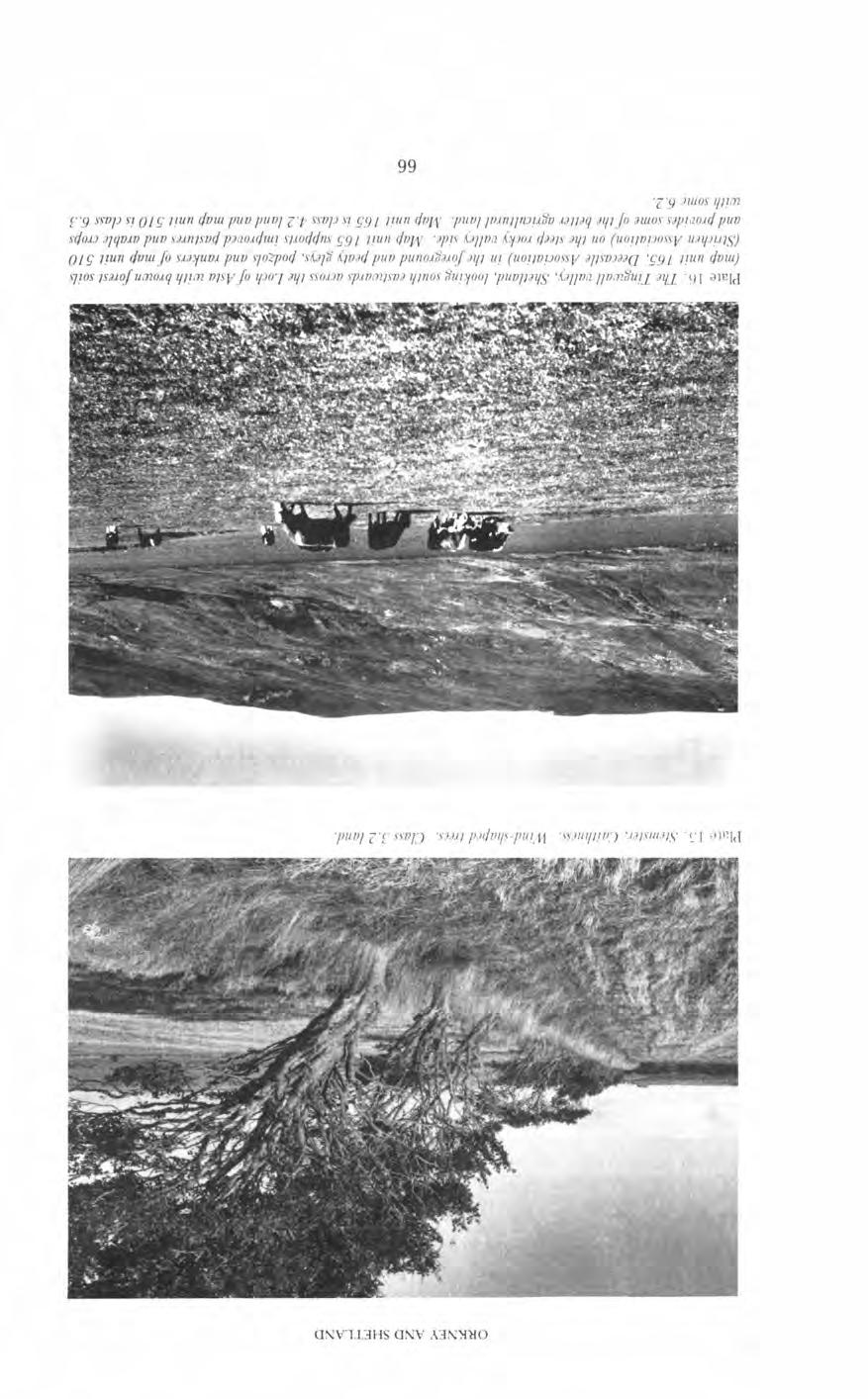
74
 and dominates the arable landscapes of Orkney and Shetland.")
75 LAND EVALUATION variable, ranging from loamy sand to loam, and as a result minor soil pattern limitations are imposed but again it is climate that is the principal limiting factor. Dirkion 2 Class 4.2 land occupies 443 square kilometres (15.2 per cent of the land area) and dominates the arable landscapes of Orkney and Shetland. The land is primarily grassland but with some limited potential for other crops, mainly forage crops, potatoes and cereals for stock-feed. Grass yields can be high but difficulties of utilization or conservation may be severe. The soil map units included in the division are shown in Table C. The majority are based predominantly on poorly drained noncalcareous gleys and peaty gleys. The soils are capable of arable cropping but suffer either an adverse climate or are liable to structural damage because of poor workability and trafficability. The gleys are generally surfacewater gleys developed on compact and slowly permeable sandy clay loam or clay loam till. The soils demand intensive drainage schemes with permeable infill extending to the base of the Ap horizon. Both the Ap horizons and the Bg horizons often have high fine sand and silt contents and the infill acts as an essential filter. The soils benefit from secondary drainage treatments such as sub-soiling. The landscape is such that it is often difficult to provide sufficient fall for the drains without deep and costly ditches. In many instances the drains are eventually blocked by ochre. The susceptibility of soils to structural damage by cultivations, traffic and stock, with the consequent penalties for crop production is governed by three main factors: (i) soil drainage and the depth to an impermeable horizon. (ii) the water-retention properties of the topsoil. (These properties are related broadly to texture and organic-matter content; coarse- and moderately coarse- textured materials have a low retention capacity while moderately fine- and fine-textured materials have a high retention capacity and stay wetter longer. Organic horizons and horizons with a high organic-matter content also have high water-retention capacities). (iii) climate and particularly the length of the field capacity period. The wetter the soils the more liable they are to damage and the greater the need for comprehensive drainage. Some areas of peaty podzols are included in the division, the organic surface horizons in these instances being sufficiently thin to encourage and permit reclamation and allowing arable cropping to be established. Areas dominated by magnesian gleys, as at Baltasound, Unst, are included in the division. The soils are poorly or imperfectly drained with a thin humose surface horizon and demand drainage but an uneven thickness of drift-cover and the local proximity of rock can interfere with, and cause difficulties in, the lay-out of the drainage scheme. A major limitation in these soils is their chemistry. The soils contain high amounts of magnesium, iron and nickel; phosphate demands are heavy, as applied soluble phosphate is rendered unavailable by ready reaction with iron, and nickel toxicity in grazing stock can be a problem. Map unit 165-mainly brown forest soils of the Deecastle Association and found particularly in the Tingwall Valley, Shetland- is included in this division. Soil, drainage and pattern limitations are minimal and it is the climate that is the principal limiting factor in this instance. Class 5 The agricultural use of land in Class 5 is restricted to grass production. Mechanized surface treatments to improve grassland are practical. An occasional forage 67

76 ORlCllEY AND SHETLAND crop or cereal crop for stock-feed may be grown but the land is generally unsuitable for arable cropping. Diuziion I In Class 5.1 land the establishment of a grass sward and its maintenance present few problems and potential yields are high with ample growth throughout the season. Patterns of soil, slope or wetness may be slightly restricting but the land has few poaching problems and high stocking rates are possible. The division occupies 50 square kilometres (1.7 per cent of the land area) and occurs in northeast Caithness where it is associated with soils developed on windblown shelly sand, and in Orkney on the hummocky moraine complex of map unit 539, on the rock-ridged complex of map unit 80 and on the steep slopes of map unit 151. The windblown shelly sands of north-east Caithness have generally high ph values which can result in trace element problems and induce, perhaps in particular, manganese deficiencies. The coarse- textured material is liable to wind erosion especially when the vegetation cover is breached. Slope, soil pattern and stoniness are additional limitations to that of climate in map unit 5?9 in Orkney. Diuision 2 Class 5.2 land presents none or few difficulties in the establishment of a sward but sometimes moderate or low trafficability, patterned land and slope may cause problems. Growth rates can be high and despite some problems of poaching satisfactory stocking rates can be achieved. The division occupies 359 square kilometres (12.3 per cent of the land area) and is of widespread and local distribution. The majority of soil map units included within the division (Table C) are based principally on poorly drained gley soils which necessitate comprehensive drainage schemes. The soils occur in an adverse climatic regime and are often shallow with limitations on available rooting depth. Organic surface horizons are thin, only rarely exceeding 30 centimetres and do not offer undue impediment to 68
77 LAND EVALUATION machinery under normal moisture conditions. Drainage schemes demand constant attention and the blocking of drains by ochre is often a severe problem and particularly so in the peaty gleys. Magnesian gleys around Baltasound, Unst are included in this division. The soils are often strongly eroded and exhibit pattern limitations. The unique soil limitations due to the chemistry of the soils militates further against their potential. A number of units based dominantly on peaty podzols are included in the division. The organic surface horizons are insufficiently thick to cause major trafficability problems in all but the wettest periods. Three units based on windblow sand (map units 261, 262 and 380) are considered within the division. The soils suffer a particularly adverse climate and are liable to severe wind erosion especially when the vegetation cover is breached by either natural or artificial means. They may have fertility problems associated with high ph values, low organic-matter content and low clay values, while map unit 262 is wet with a high water-table and is subjected to periodic flooding. The units occur most extensively in the northern isles of Orkney, particularly in Westray, Sanday and North Ronaldsay and around many of the broad, shallow bays of Mainland Orkney and Shetland. Some arable cropping, mainly oats on the high ph soils, is undertakeq but the risks are great. Seed-beds can be destroyed by wind erosion and manganese deficiencies are recurring problems requiring specialized treatments. Units based on brown forest soils with rankers are included in the division. Trafficability is not a problem but soil pattern, particularly in respect of rock outcrop, and slope are major limitations. Dimiion 3 In Class 5.3 the land experiences an adverse climate and usually has properties that lead to serious trafficability problems; although an initial sward establishment may be relatively easy, deterioration in quality is often rapid. The land cannot support high stocking rates without suffering structural damage which may be serious even in summer after heavy rain and possibly irreversible. The soil map units included in the division are shown in Table C. The division occupies 174 square kilometres (6 per cent of the land area) and is of widespread and local distribution. The majority of the units are dominated by peaty gleys and peaty podzols with shallow peat and display major problems of trafficability. The climate is commonly poor, and the organic surface horizons are wet and thick enough to militate against the use of machinery in reclamation in all but the driest months. The soils are only marginally suited to reclamation and such exercises will be costly in terms of finance and time. Trafficability is not a major problem in map unit 372-a unit based on magnesian gleys and occurring on Unst and Fetlar, but climate, soil pattern particularly in respect of rock outcrop and erosion, and limitations associated with chemistry and fertilizer demands are constraints on land use and on the practicalities of improvement. Exposed areas of North Ronaldsay and the eastern seaboard of Orkney are similarly included in this division; trafficability is not a problem but erosion imposes pattern limitations and the soils have serious limitations associated with the high contents of sodium and magnesium. Some areas of basin and valley peat in south Mainland Shetland are included in this division. Class 6 Class 6 land has very severe site, soil or wetness limitations which generally prevent the use of tractor-operated machinery for improvement. Reclamation of 69
78 ORKNEY AND SHETLAND Tabh B Areas of land capability for agriculture map units CLASS and DIVISION -- SHEET 1 ORKNEY and % N E CAITHNESS SHETLAND OVERALL LAND AREA SCOTLAND % so. KM. LAND AREA ( BUILT-UP AREAS TOTAL sq. km. = 100 hectares Areas in bolh this [able and iri table A haue been estimated by poiiil-count methodr. Care should be exercised in calrulaiioiu inuolvirig uni& of less lhan 10 square kilometres. Iliscussion of method and estinraliori of error is contained in Hrndbook 8. small areas, by open-ditching and surface seeding for example, to encourage stock to range is possible. Climate is often a significant limiting factor. The class is divided into three on the basis of the assessment of relative grazing values. Dzvlsion I Class 6.1 has high relative grazing values, the results of a high proportion of palatable herbage in the sward. The division is of very limited extent (2 square 70
79 LAND EVALUATION Table C Land capability for agiculture, classes, divisions and soil m p units CLASS DIVISION SOll. MAP UNITS , 536, 537, , , 79, 80, 11 7, , 459, 535, , , 240, , , , 399,400,459,478, , 535, 537, , , , 459, , ,459, , 29, , , ,380,461,478, , , , 330, , 461, 510, , 544, , 571, kilometres; less than 0.3 per cent of the land area) and is restricted to south Mainland Shetland. Excessive rockiness and steepness of slope are the principal restrictions. Diiision 2 Class 6.2 land has moderate grazing values, the vegetation being dominated by such moderate quality herbage as white and flying bent grasslands, rush pastures and herb-rich moorlands or occurring as a mosaic of herbage of both high and low grazing values. The division occupies 134 square kilometres (4.6 per cent of the land area); the soil map units included within the division are shown in Table C. Most of the units occur on steep and very steep slopes, the slopes being sufficiently steep to preclude the use of tractors. Additional limitations can include wetness including flushing, the presence of organic surface horizons and rockiness. Map units based dominantly on saline gleys and occurring most particularly on the western seaboard of the Orkney archipelago are subjected to saltspray and sea-gusting. The map units occur on gentle and strong slopes which may be bouldery but are generally non-rocky. They are, however, commonly strongly eroded with the vegetation cover much broken. The soils support the characteristic and unique vegetation of sea plantain-crowberry heath and vernal squill maritime pasture. Areas of windblown sand where particularly exposed and most vulnerable to erosion are similarly included in the class; the soils are 71
80 ORKNEY ANI) SHETLAND generally immature with thin surface horizons. The vegetation cover of northern dune and dune pasture is often broken and periodically overwhelmed by blown sand. Maritime influence and grazing have marked effects on the vegetation; the ericeous plants tend to be suppressed and a replacement mosaic of perhaps herbrich rough grasslands and maritime heath may be established as occurs immediately north of Mavis Grind in north-west Shetland. Dz'miion 3 Class 6.3 land is dominated by plant communities with low relative grazing values, particularly Atlantic heather moor, bog heather moor and blanket bog. It occupies 1262 square kilometres or 43.2 per cent of the land area (Table B). The soils are generally peaty and wet and occur on a wide variety of landfornis; the soil map units included within the division are shown in Table C. Soil limitations, wetness, slope, soil pattern and climate all militate strongly against improvement. Some open-ditch drainage of peatland is possible but major improvements are not practical. Class 7 Class 7 land is of very limited agricultural value, land use being restricted to generally seasonal rough grazings. The land has extremely severe limitations that cannot be rectified and vegetation cover is generally sparse and much broken. The class occupies 24 square kilometres (0.8 per cent of the land area) and occurs on the plateau summits of the highest hills of Hoy, on Ronas Hill in north-west Shetland and on the very steep and rocky hillsides of Beorgs of Skelberry in North Roe, Shetland. Table B shows the paucity of land suitable for arable cultivations in Shetland. Climate restrictions in particular limit the most potentially productive land to Class 4.2 and the division occupies a mere 3 per cent of Shetland while Classes 6 and 7 occupy 70 per cent. The figures show some 25 per cent of class 5 landland capable of use as improved grassland in Shetland and indicate the potential value, in terms of improved grazing and greater carrying capacity of Class 5 land to the Shetland economy. Orkney and north-east Caithness display a completely different picture. Land suitable for arable cultivations amounts to some 56 per cent of the land area of Orkney and north-east Caithness while Class 5 land occupies 15 per cent. The limits of scale determine that the land capability classes discussed will contain areas of both higher and lower agricultural potential. LAND CAPABILITY FOR FORESTRY The extremes of climate, the salt-laden air, the ever-present danger of gale-force winds and the pressures on land for arable and grassland cropping militate most strongly and effectively against commercial forestry. The Forestry Commission have an established plantation on blown shelly sand at Dunnet in north-east Caithness; tree growth is slow and wind-pruning extreme but the effects of mutual shelter are becoming obvious. Experimental blocks have been laid out in north-east Caithness at Acharole and at Spital to examine problems of drainage and nutrition in tree establishment on deep peat. Four experimental blocks were set up in Hoy in 1974 with lodgepole pine, Scots pine, Sitka spruce and mountain pine dominating. With the exception of Scots pine, survival rate is high but growth is much retarded. 72

81 LAND EVALUATION A number of hardwood shelter belts are established throughout the area and show that species such as sycamore, ash, beech and larch can survive the adverse conditions of extreme exposure and salt-laden air. OTHER APPLICATIONS OF SOIL SURVEY The area has much to offer in terms of ornithology, botany, archaeology, fishing and sailing and has a number of superb beaches for the occasional sand-yachter or the less-active members of society. The factors associated with recreation are numerous but it is perhaps in problems associated with (a) the establishment of long-term camping or caravan sites and (b) freedom of access, that soil properties must be most seriously evaluated. Five basic factors must be considered when the suitability of an area of land for a site is assessed: (a) the protection of existing high amenity values; (b) access to the site and the susceptibility of the soils to structural damage; (c) the prevention of acceleration of the natural processes of erosion; (d) topography- relief, aspect and the degree of shelter; and (e) the safe disposal of sewage and kindred wastes. The planning of footpaths will demand attention to the first three factors in particular. Wet soils and soils with either organic or highly humose horizons are most susceptible to structural damage by poaching and traffic. The dangers of puddling and minor flooding are ever present. The soils in which erosion might most easily be promoted by human activity are those developed on windblown sand. The soils are coarsely textured, very friable and weakly structured with low organic-matter contents and are liable to often severe wind erosion once the vegetation cover is breached. The disposal of sewage will most usually be by septic tanks with the consequent necessity for a stable and efficient soak-away system. Soils developed on the thicker slowly permeable till cannot be regarded as suitable mediums for a soakaway. In the more shallow soils the underlying rock might be utilized but its efficiency would be closely related to the nature of the rock. If the five fundamental requirements are rigorously invoked then the number of soil map units that might be suitable for the establishment of a long-term site is small. Ideally the soils should be freely or imperfectly drained, not liable to erosion and capable of providing an efficient soak-away. The site should be gently sloping and regular and offer a degree of shelter. Parts of those soil map units based predominantly on brown forest soils offer the best possibilities from a soils viewpoint but then the same units correspond with some of the best agricultural soils and an obvious conflict of interest arises. As a secondary choice, some areas of soil map units 117, 459, 478, 537, 569 and 570 might be considered. Map unit 117 in this instance does however correspond with some of the better agricultural soils of Shetland. In all cases it is the provision of an adequate sewage system that would pose the major problem. In map unit 537 only those areas of relatively shallow till should be considered as possible sites. As stated earlier the area has much to offer the botanist for a number of interesting and possibly unique vegetation communities are established, for example, the sea plantain-crowberry heath and maritime pasture of the exposed seaboard, the unique sea plantain-bell heather moor on soils of the Leslie Association, the vegetation of the serpentine barrens, the alpine vegetation of the hill tops, the species-rich pastures of windblown shelly sands and the natural woodlands of Berriedale and Burn of Segal in Hoy. Many of these communities are, however, vulnerable and possibly liable to ultimate destruction by excessive human activities. 73
The Soils and Land Capability for Agriculture. Land North of Aberdeen, Aberdeenshire
 The Soils and Land Capability for Agriculture Of Land North of Aberdeen, Aberdeenshire Report prepared for Peter Radmall Associates May 2012 Reading Agricultural Consultants Ltd Beechwood Court, Long Toll,
Higher Geography Paper one Physical and Human environment Biosphere Model answers
 Higher Geography Paper one Physical and Human environment Biosphere Model answers Soil profile model answer Podzol Select one of the following soil types: 1. Podzol 2. Brown Earth 3. Gley With the aid
The elevations on the interior plateau generally vary between 300 and 650 meters with
 11 2. HYDROLOGICAL SETTING 2.1 Physical Features and Relief Labrador is bounded in the east by the Labrador Sea (Atlantic Ocean), in the west by the watershed divide, and in the south, for the most part,
BIOSPHERE. Vegetation plant succession Psammoseres sand dune successions
 Vegetation plant succession Psammoseres sand dune successions 1 What do you need to know? Evolution of vegetation communities to climax states Example: Coastal dune belts 2/3 examples of plants and their
Chapter 6, Part Colonizers arriving in North America found extremely landscapes. It looked different to region showing great.
 Social Studies 9 Unit 1 Worksheet Chapter 6, Part 1. 1. Colonizers arriving in North America found extremely landscapes. It looked different to region showing great. 2. The Earth is years old and is composed
GEOLOGY OF TODMORDEN MOOR 2 BACKGROUND
 GEOLOGY OF TODMORDEN MOOR 2 BACKGROUND 1) THE CARBONIFEROUS SERIES OF ROCKS The rocks of the Todmorden district are of the Carboniferous Series and were first laid down in an ancient sea, which covered
Favourable Condition of Blanket Bog on Peak District SSSIs. Richard Pollitt Lead Adviser, Conservation & Land Management, Dark and South West Peak
 Favourable Condition of Blanket Bog on Peak District SSSIs Richard Pollitt Lead Adviser, Conservation & Land Management, Dark and South West Peak Definitions SSSI Site of Special Scientific Interest statutory
Chapter 2. Regional Landscapes and the Hydrologic Cycle
 Chapter 2. Regional Landscapes and the Hydrologic Cycle W. Lee Daniels Department of Crop and Soil Environmental Sciences, Virginia Tech Table of Contents Introduction... 23 Soils and landscapes of the
Surface Processes on the Earth. Rocks, Weathering, Erosion and Soil
 Surface Processes on the Earth Rocks, Weathering, Erosion and Soil ROCKS AND ROCK CYCLE Rock types Three main types of rock Igneous Metamorphic Sedimentary Igneous Form when magma or lava cools and hardens
Bell Ringer. Are soil and dirt the same material? In your explanation be sure to talk about plants.
 Bell Ringer Are soil and dirt the same material? In your explanation be sure to talk about plants. 5.3 Mass Movements Triggers of Mass Movements The transfer of rock and soil downslope due to gravity is
Ecoregions Glossary. 7.8B: Changes To Texas Land Earth and Space
 Ecoregions Glossary Ecoregions The term ecoregions was developed by combining the terms ecology and region. Ecology is the study of the interrelationship of organisms and their environments. The term,
What landforms make up Australia?!
 What landforms make up Australia? The tectonic forces of folding, faulting and volcanic activity have created many of Australia's major landforms. Other forces that work on the surface of Australia, and
Higher Geography Biosphere Vegetation Succession: Sand Dunes
 Higher Geography Biosphere Vegetation Succession: Sand Dunes A PowerPoint resource to accompany the posters available at: http://www.macaulay.ac.uk/soilposters/education_vegetation_6v2.pdf http://www.macaulay.ac.uk/soilposters/education_vegetation_7v2.pdf
Permafrost-influenced Geomorphic Processes
 Section 4 Permafrost-influenced Geomorphic Processes Geomorphic processes vary greatly among ecoregions in northern Alaska, extending from the Beaufort Sea coast to the Brooks Range (Figure 4.1). Regional
Module 10: Resources and Virginia Geology Topic 4 Content: Virginia Geology Notes
 Virginia is composed of a very diverse landscape that extends from the beaches and barrier islands all of the way to the highly elevated Appalachian Plateau. Geologists have discovered ancient shallow
Pratice Surface Processes Test
 1. The cross section below shows the movement of wind-driven sand particles that strike a partly exposed basalt cobble located at the surface of a windy desert. Which cross section best represents the
Chapter 10. Chapter Rocks and the Rock Cycle. Rocks. Section 1 Rocks and the Rock Cycle
 Chapter 10 Rocks 1 Chapter 10 Section 1 Rocks and the Rock Cycle 2 10.1 Rocks and the Rock Cycle Magma is the parent material for all rocks. Once the magma cools and hardens, many changes can occur. Geology:
Landscape evolution. An Anthropic landscape is the landscape modified by humans for their activities and life
 Landforms Landscape evolution A Natural landscape is the original landscape that exists before it is acted upon by human culture. An Anthropic landscape is the landscape modified by humans for their activities
Prentice Hall EARTH SCIENCE
 Prentice Hall EARTH SCIENCE Tarbuck Lutgens Chapter 7 Glaciers, Desert, and Wind 7.1 Glaciers Types of Glaciers A glacier is a thick ice mass that forms above the snowline over hundreds or thousands of
1. Any process that causes rock to crack or break into pieces is called physical weathering. Initial product = final product
 Weathering 1. Any process that causes rock to crack or break into pieces is called physical weathering. Initial product = final product End Result of physical weathering is increased surface area. 2. Physical
Wednesday, November 15, 2017
 Wednesday, November 15, 2017 Northern Europe: Physical Geography Objective: Locate and describe the various traditional regions of Western Europe. Outline how the physical geography varies from region
Continental Landscapes
 Continental Landscapes Landscape influenced by tectonics, climate & differential weathering Most landforms developed within the last 2 million years System moves toward an equilibrium Continental Landscapes
Weathering, Erosion and Deposition
 Weathering, Erosion and Deposition Shaping the Earth s Surface Weathering the process of breaking down rocks into smaller fragments Erosion the transport of rock fragments from one location to another
A Geological Tour of Tumbledown Mountain, Maine
 Maine Geologic Facts and Localities April, 1998 A Geological Tour of Tumbledown Mountain, Maine 44 45 3.21 N, 70 32 50.24 W Text by Robert G. Marvinney, Department of Agriculture, Conservation & Forestry
EARTH S CHANGING SURFACE
 EARTH S CHANGING SURFACE Weathering Together, weathering and erosion work continuously to wear down the material on Earth s surface. weathering process that breaks down rock and other substances of Earth
Lab 7: Sedimentary Structures
 Name: Lab 7: Sedimentary Structures Sedimentary rocks account for a negligibly small fraction of Earth s mass, yet they are commonly encountered because the processes that form them are ubiquitous in the
STUDY GUIDE FOR CONTENT MASTERY. Surface Water Movement
 Surface Water SECTION 9.1 Surface Water Movement In your textbook, read about surface water and the way in which it moves sediment. Complete each statement. 1. An excessive amount of water flowing downslope
6.E E Rock Cycle/Weathering/Soil
 Name: Date: 1. A lake is surrounded by hills covered with trees and shrubs. Which statement correctly describes how a change to the plants in this area will affect this environment? A. Adding plants to
4. The map below shows a meandering stream. Points A, B, C, and D represent locations along the stream bottom.
 1. Sediment is deposited as a river enters a lake because the A) velocity of the river decreases B) force of gravity decreases C) volume of water increases D) slope of the river increases 2. Which diagram
Chapter 2. Wearing Down Landforms: Rivers and Ice. Physical Weathering
 Chapter 2 Wearing Down Landforms: Rivers and Ice Physical Weathering Weathering vs. Erosion Weathering is the breakdown of rock and minerals. Erosion is a two fold process that starts with 1) breakdown
MAFF Ministry of IfiriLE Agriculture Fisheries and Food
 MAFF Ministry of IfiriLE Agriculture Fisheries and Food STATEMENT OF PHYSICAL CHARACTERISTICS AND AGRICULTURAL LAND CLASSIFICATION UPSLAND, KIRKLINGTON NORTH YORKSHIRE EXTRACTION OF SAND AND GRAVEL MARCH
The Welsh Borderland. Geologically recent surface deposits. The Welsh Borderland
 The Welsh Borderland This account provides a broad perspective of the geology of the Welsh Borderland region which comprises the southeast of Powys, southern Shropshire, northern Gwent, the western half
2. PHYSICAL FEATURES OF INDIA
 2. PHYSICAL FEATURES OF INDIA Question 1: Choose the right answer from the four alternatives given below. (i) A landmass bound by sea on three sides is referred to as (a) Coast (c) Peninsula (b) Island
3.2.2 Ecological units of the Des Quinze lake proposed biodiversity reserve
 3.2.2 Ecological units of the proposed biodiversity reserve An intact forest mass The proposed biodiversity reserve (see appendix 3) protects terrestrial environments almost exclusively. Proximity of Des
Description DESCRIPTION
 DESCRIPTION The location of the Upper James Watershed is located in northeastern South Dakota as well as southeastern North Dakota. It includes the following counties located in North Dakota Barnes, Dickey,
Soil is formed from the weathering of rocks. Weathering: the breaking down of parent material (rock). There are 3 types of weathering:
. There are 3 types of weathering:") Soil is formed from the weathering of rocks. Weathering: the breaking down of parent material (rock). There are 3 types of weathering: Physical, Chemical Biological. The natural forces carry this out:
Soil is formed from the weathering of rocks. Weathering: the breaking down of parent material (rock). There are 3 types of weathering: Physical, Chemical Biological. The natural forces carry this out:
SOIL INFORMATION FOR PUMPED WATER STORAGE SCHEME, STEELPOORT VALLEY
 REPORT On contract research for Bohlweki Environmental SOIL INFORMATION FOR PUMPED WATER STORAGE SCHEME, STEELPOORT VALLEY February 2007 By D.G. Paterson ARC-Institute for Soil, Climate and Water, Private
Chapter 7 Case study. Sand dune coastal environment: Studland Bay
 Sand dune coastal environment: Studland Bay Sand dunes are common features of low-lying stretches of coastline in the UK and elsewhere in the world. They form in places where there is a plentiful supply
Geology and New England Landscapes
 Geology and New England Landscapes Jim Turenne, CPSS USDA-NRCS Warwick, RI. http://nesoil.com Why Geology? Provides the big picture of site conditions. Major part of soil formation (parent material and
The Geology of Sebago Lake State Park
 Maine Geologic Facts and Localities September, 2002 43 55 17.46 N, 70 34 13.07 W Text by Robert Johnston, Department of Agriculture, Conservation & Forestry 1 Map by Robert Johnston Introduction Sebago
Landforms. Why does the land look like it does? 1. Controlled by water 2. Controlled by the rocks
 Landforms Why does the land look like it does? 1. Controlled by water 2. Controlled by the rocks Landforms Made by Running Water Stream erosion The evolution of a river system Entrenched meanders Fluvial
Description of Wild Land Area Duirinish Wild Land Area
 22 Duirinish Wild Land Area 1 Context Duirinish is one of the 11 island Wild Land Areas (WLA), one of two on the Isle of Skye. At 43 km 2 it is one of the smallest nationally, located in the far north
Weathering, Erosion, Deposition, and Landscape Development
 Weathering, Erosion, Deposition, and Landscape Development I. Weathering - the breakdown of rocks into smaller particles, also called sediments, by natural processes. Weathering is further divided into
Name. 4. The diagram below shows a soil profile formed in an area of granite bedrock. Four different soil horizons, A, B, C, and D, are shown.
 Name 1. In the cross section of the hill shown below, which rock units are probably most resistant to weathering? 4. The diagram below shows a soil profile formed in an area of granite bedrock. Four different
Name a sedimentary rock and explain how was it formed. Y11 Changing landscapes of the UK
 Name a sedimentary rock and explain how was it formed Small particles that have been transported and deposited in layers, such as sandstone; or from the remains of plants and animals e.g. chalk. Pressure
GEOLOGY OF THE NICOLA GROUP BETWEEN MISSEZULA LAKE AND ALLISON LAKE
 GEOLOGY OF THE NICOLA GROUP BETWEEN MISSEZULA LAKE AND ALLISON LAKE (92H/15E. 10E1 By V. A. Preto INTRODUCTION Mapping was continued southward from the area covered in 1973 and an additional 55 square
Landforms and Rock Structure
 Landforms and Rock Structure Rock Structure as a Landform Control Landforms of Horizontal Strata and Coastal Plains Landforms of Warped Rock Layers Landforms Developed on Other Land-Mass Types Landforms
Topic 6: Weathering, Erosion and Erosional-Deposition Systems (workbook p ) Workbook Chapter 4, 5 WEATHERING
 Workbook Chapter 4, 5 WEATHERING") Topic 6: Weathering, Erosion and Erosional-Deposition Systems (workbook p. 95-125) Workbook Chapter 4, 5 THE BIG PICTURE: Weathering, erosion and deposition are processes that cause changes to rock material
Topic 6: Weathering, Erosion and Erosional-Deposition Systems (workbook p. 95-125) Workbook Chapter 4, 5 THE BIG PICTURE: Weathering, erosion and deposition are processes that cause changes to rock material
Weathering, Erosion & Soils Quiz
 Weathering, Erosion & Soils Quiz Multiple Choice Identify the choice that best completes the statement or answers the question. 1. The diagram below shows a cross-section of a rock layer. Erosion is the
Unit 3 Review - Surface Processes
 Unit 3 Review - Surface Processes 1. Why is the surface of Mercury covered with meteor impact craters, while Earth s surface has relatively few craters? A) Mercury is larger than Earth, so it gets hit
Bradbury Mountain, Pownal, Maine
 Maine Geologic Facts and Localities August, 2008 Bradbury Mountain, Pownal, Maine 43 o 53 56.56 N, 70 o 10 45.11 W Text by Henry N. Berry IV, Department of Agriculture, Conservation & Forestry 1 Introduction
National Meteorological Library and Archive
 National Meteorological Library and Archive Fact sheet No. 4 Climate of the United Kingdom Causes of the weather in the United Kingdom The United Kingdom lies in the latitude of predominately westerly
EQ: Discuss main geographic landforms of the U.S. & Canada and examine varied landforms in relation to their lifestyles.
 EQ: Discuss main geographic landforms of the U.S. & Canada and examine varied landforms in relation to their lifestyles. Places & Terms for Discussion Appalachian Mountains Great Plains Canadian Shield
Erosion and Deposition
 Erosion and Deposition Erosion Sediment natural forces move rock/soil from one place to another. gravity, water, wind, glaciers, waves are causes material moved by erosion Deposition when erosion lays
Biosphere. All living things, plants, animals, (even you!) are part of the zone of the earth called the biosphere.
 are part of the zone of the earth called the biosphere.") Unit 1 Study Guide Earth s Spheres Biosphere All living things, plants, animals, (even you!) are part of the zone of the earth called the biosphere. Hydrosphere Water covers ¾ of the earth, made up mostly
Unit 1 Study Guide Earth s Spheres Biosphere All living things, plants, animals, (even you!) are part of the zone of the earth called the biosphere. Hydrosphere Water covers ¾ of the earth, made up mostly
Weathering, Soil, and Mass Movements
 Tarbuck Lutgens Weathering, Soil, and Mass Movements 5.1 Weathering Mechanical Weathering Mechanical weathering occurs when physical forces break rock into smaller and smaller pieces without changing the
Section I: Multiple Choice Select the best answer to each question. Mark your final answer on the answer sheet. (1 pt each)
") Sedimentary Rocks & Surface Processes Quest Name: Earth Science 2013 Block: Date: Section I: Multiple Choice Select the best answer to each question. Mark your final answer on the answer sheet. (1 pt each)
Sedimentary Rocks & Surface Processes Quest Name: Earth Science 2013 Block: Date: Section I: Multiple Choice Select the best answer to each question. Mark your final answer on the answer sheet. (1 pt each)
(version 3) I. HumAN -Environment Interaction
 I. HumAN -Environment Interaction") (version 3) I. HumAN -Environment Interaction A. Landforms 1. Earth s topography is made up of many different types of landforms. 2. While the planet is covered primarily with water, the four major types
(version 3) I. HumAN -Environment Interaction A. Landforms 1. Earth s topography is made up of many different types of landforms. 2. While the planet is covered primarily with water, the four major types
As compaction and cementation of these sediments eventually occur, which area will become siltstone? A) A B) B C) C D) D
 A B) B C) C D) D") 1. A student obtains a cup of quartz sand from a beach. A saltwater solution is poured into the sand and allowed to evaporate. The mineral residue from the saltwater solution cements the sand grains together,
1. A student obtains a cup of quartz sand from a beach. A saltwater solution is poured into the sand and allowed to evaporate. The mineral residue from the saltwater solution cements the sand grains together,
BUTE MAP 6: GARROCH HEAD to STRAVANNAN BAY
 BUTE MAP 6: GARROCH HEAD to STRAVANNAN BAY Hinterland Geology and Coastal Geomorphology: Old Red Sandstone and lavas form the principal base deposits and are overlain by marine deposits towards Port Dornoch.
Classify Rock (rock1)
") Name: Date: 1. Cleavage of a mineral is related to a mineral's A. chemical composition. B. streak color. C. luster. D. crystalline structure. 2. Which is not part of the definition of a mineral? A. naturally
Name: Date: 1. Cleavage of a mineral is related to a mineral's A. chemical composition. B. streak color. C. luster. D. crystalline structure. 2. Which is not part of the definition of a mineral? A. naturally
THE TOPOGRAPHY AND GEOLOGY OF THE GRAND PORTAGE^
 THE TOPOGRAPHY AND GEOLOGY OF THE GRAND PORTAGE^ Few areas within the boundaries of Minnesota are of greater historical interest than the region surrounding the Grand Portage, which long before the first
Lowland Glaciation North Wales
 Lowland Glaciation North Wales Background Although there have been many glaciations and advances in ice, the most significant for this are was the Dimlington Stadial which was a period of glacial advance
Soils and Soil Minerals. Remember, most things can be too little or too much.
 Soils and Soil Minerals Remember, most things can be too little or too much. 1 2 3 Source of essential elements CO 2, O 2 from atmosphere H 2 0, O 2, minerals from soil NH 4, SO 4 can volatilize and be
Earth Science, 10e. Edward J. Tarbuck & Frederick K. Lutgens
 Earth Science, 10e Edward J. Tarbuck & Frederick K. Lutgens Weathering, Soil, and Mass Wasting Chapter 3 Earth Science, 10e Stan Hatfield and Ken Pinzke Southwestern Illinois College Earth's external processes
Classification according to patent rock material/origin, soil distribution and orders
 Classification according to patent rock material/origin, soil distribution and orders Alluvial Soils Shales and Sandstone Soils Limestone Soils Chocolate Hills: Limestone formation Andesite and Basalt
Tiree s great yellow bumblebee project
 Tiree s great yellow bumblebee project * * * * * Facts about the great yellow bumblebee LATIN NAME Bombus distinguendus GAELIC NAME Seillean mòr buidhe HOW RARE ARE THEY? It s one of the UK s rarest bumblebees
Name: Which rock layers appear to be most resistant to weathering? A) A, C, and E B) B and D
 A, C, and E B) B and D") Name: 1) The formation of soil is primarily the result of A) stream deposition and runoff B) precipitation and wind erosion C) stream erosion and mass movement D) weathering and biological activity 2)
Name: 1) The formation of soil is primarily the result of A) stream deposition and runoff B) precipitation and wind erosion C) stream erosion and mass movement D) weathering and biological activity 2)
LAB 2 IDENTIFYING MATERIALS FOR MAKING SOILS: ROCK AND PARENT MATERIALS
 LAB 2 IDENTIFYING MATERIALS FOR MAKING SOILS: ROCK AND PARENT MATERIALS Learning outcomes The student is able to: 1. understand and identify rocks 2. understand and identify parent materials 3. recognize
Soil Formation. Parent Material. Time. Climate
 Soil Formation Parent Material Time Climate Topography Biota Main Objectives 1. Gain a general understanding of soil formation processes 2. Understand the importance of mineral weathering in soil formation
3.13Glaciers past and present
 3.13Glaciers past and present We start with a headline from The Scotsman newspaper that rocked Britain s scientific establishment on the morning of 7 October 1840: 3 Discovery of the Former Existence of
Chapter 2: Geomorphology of the Swan Coastal Plain
 Chapter 2: Geomorphology of the Swan Coastal Plain 2.1 Overview of geology This introduction is not meant to be a comprehensive description of the geology of the Australian continent. The intention is
Essential Questions. What is erosion? What is mass wasting?
 Erosion Essential Questions What is erosion? What is mass wasting? What is Erosion? Erosion The transportation of sediment from one area to another Caused mainly by running water but also caused by glaciers,
Answers: Internal Processes and Structures (Isostasy)
") Answers: Internal Processes and Structures (Isostasy) 1. Analyse the adjustment of the crust to changes in loads associated with volcanism, mountain building, erosion, and glaciation by using the concept
Answers: Internal Processes and Structures (Isostasy) 1. Analyse the adjustment of the crust to changes in loads associated with volcanism, mountain building, erosion, and glaciation by using the concept
3.3 CLIMATE, GEOLOGY, TOPOGRAPHY, AND SOILS CLIMATE GEOLOGY TOPOGRAPHY
 3.3 CLIMATE, GEOLOGY, TOPOGRAPHY, AND SOILS This section describes the climate, geology, topography, and soil resource characteristics of the Yolo Bypass Wildlife Area (Wildlife Area). Agricultural soil
Landforms in Canada. Canada is made up of three dis;nct types of landforms: Canadian Shield Highlands Lowlands
 Canada s Landforms What is a Landform? A landform is any physical feature of the Earth s surface having a characteris;c, recognizable shape, produced by natural causes. Landforms include major features
Erosion and Deposition
 Erosion and Deposition The Erosion-Deposition Process What do you think? Read the two statements below and decide whether you agree or disagree with them. Place an A in the Before column if you agree with
Tropical Moist Rainforest
 Tropical or Lowlatitude Climates: Controlled by equatorial tropical air masses Tropical Moist Rainforest Rainfall is heavy in all months - more than 250 cm. (100 in.). Common temperatures of 27 C (80 F)
Map Introduction: South Uist Map 1
 96 Map Introduction: Map This map section covers part of the south coast of, including the head of the causeway which links the island to Eriskay. It extends from South Glen Dale to Taobh a'caolas. There
Objectives. Introduction to Soils. Terms to know: What is soil? Study of Soils. The Soil Body 11/9/2012
 Objectives Explain what soil is and where it comes from Define a soil body List examples of the five soil-forming factors Explain how soils develop Introduction to Soils Terms to know: What is soil? Alluvial
CHAPTER 6 & 7 VOCABULARY
 CHAPTER 6 & 7 VOCABULARY 1. Biome 2. Climate 3. Latitude 4. Altitude 5. Emergent layer 6. Epiphyte 7. Understory 8. Permafrost 9. Wetland 10.Plankton 11.Nekton 12.Benthos 13.Littoral zone 14.Benthic zone
Topographical Maps ANSWER KEY- Assignment 6
 Topographical Maps ANSWER KEY- Assignment 6 Question 1 (To be answered using toposheet 45 D/7, Grid reference 76 to 85) 1. Cite two differences between the Sipu River and the Mahadeviyo Nala? Sipu River
1. The diagram below shows the stump of a tree whose root grew into a small crack in bedrock and split the rock apart.
 1. The diagram below shows the stump of a tree whose root grew into a small crack in bedrock and split the rock apart. 4. Which process involves either a physical or chemical breakdown of earth materials?
Environmental Science
 Environmental Science A Study of Interrelationships Cui Jiansheng Hebei University of Science and Technology CH06 Kinds of Ecosystems and Communities Chapter Objectives After reading this chapter, you
Landscape. Review Note Cards
 Landscape Review Note Cards Last Ice Age Pleistocene Epoch that occurred about 22,000 Years ago Glacier A large, long lasting mass of ice which forms on land and moves downhill because of gravity. Continental
every continent has an extensive dry region! " deserts are as much as 1/3 of Earth s surface!
 deserts! deserts! every continent has an extensive dry region! " deserts are as much as 1/3 of Earth s surface! Hollywood portrayal of vast stretches of sand dune! " Sahara has only 10% covered by sand!
8UNIT. External dynamics of the Earth. What do you remember? Key language. Content objectives
 8UNIT External dynamics of the Earth What do you remember? Can you name the solids in the photograph? nd the liquid? Is the liquid moving? How does it move? What is the name of this formation of water?
Geology 12 FINAL EXAM PREP. Possible Written Response Exam Questions
 Geology 12 FINAL EXAM PREP Possible Written Response Exam Questions Use this study guide to prepare for the written response portion of the final exam. Name FINAL EXAM - POSSIBLE WRITTEN RESPONSE QUESTIONS
A journey through the earth history of Australia s Coastal Wilderness Part 3 The backdrop - a 70 million year old plain
 A journey through the earth history of Australia s Coastal Wilderness Part 3 The backdrop - a 70 million year old plain Monaro Plain 3. The Cretaceous Plain The western horizon behind Moruya is dominated
Unit 4: Landscapes Practice Problems
 Name: Date: 1. Soil with the greatest porosity has particles that are A. poorly sorted and densely packed B. poorly sorted and loosely packed C. well sorted and densely packed D. well sorted and loosely
Sediment and sedimentary rocks Sediment
 Sediment and sedimentary rocks Sediment From sediments to sedimentary rocks (transportation, deposition, preservation and lithification) Types of sedimentary rocks (clastic, chemical and organic) Sedimentary
Introduction to Soil Science and Wetlands Kids at Wilderness Camp
 Introduction to Soil Science and Wetlands Kids at Wilderness Camp Presented by: Mr. Brian Oram, PG, PASEO B.F. Environmental Consultants http://www.bfenvironmental.com and Keystone Clean Water Team http://www.pacleanwater.org
1/6/ th Grade Earth s Surface. Chapter 3: Erosion and Deposition. Lesson 1 (Mass Movement)
") Lesson 1 (Mass Movement) 7 th Grade Earth s Surface Chapter 3: Erosion and Deposition Weathering the chemical and physical processes that break down rock at Earth s surface Mechanical weathering when rock
Lesson 1 (Mass Movement) 7 th Grade Earth s Surface Chapter 3: Erosion and Deposition Weathering the chemical and physical processes that break down rock at Earth s surface Mechanical weathering when rock
Supplemental Slides. Shore: Junction of Land & Water. Junction of Land & Water. Sea Level Variations. Shore vs. Coast. Sea Level Variations
 Shore: Junction of Land & Water Supplemental Slides Sediments come off land Most get dumped at the beach Sediment interacts with ocean waves and currents Junction of Land & Water Features: Breaking waves,
Shore: Junction of Land & Water. Sediments come off land Most get dumped at the beach Sediment interacts with ocean waves and currents
 Shore: Junction of Land & Water Supplemental Slides Sediments come off land Most get dumped at the beach Sediment interacts with ocean waves and currents Junction of Land & Water Features: Breaking waves,
Example Quiz on Earthquakes
 Example Quizzes, Tests, and Review Information A Example Quiz on Earthquakes Quizzes such as this one are given at the beginning of each lab. 1. The point beneath the Earth s surface at which an earthquake
Physiographic zones. and water quality
 Southland Physiographic zones bedrock/hill country Technical information Physiographic zones are part of the Water and Land 2020 & Beyond project that aims to maintain and improve water quality in the
The Marine Environment
 The Marine Environment SECTION 16.1 Shoreline Features In your textbook, read about erosional landforms, beaches, estuaries, longshore currents, and rip currents. For each statement below, write or. 1.
=%REPORT RECONNAISSANCE OF CHISHOLM LAKE PROSPECT. October 25, 1977
 =%REPORT ON FIELD RECONNAISSANCE OF CHISHOLM LAKE PROSPECT October 25, 1977 Bruce D. Vincent Imperial Oil Limited, Minerals - Coal, CALGARY, ALBERTA CHISHOLM LAKE PROSPECT Introduction The Chisholm Lake
The United States & Canada. A Regional Study of Anglo America
 A Regional Study of Anglo America Landform Regions of the United States & Canada world leaders in agricultural and industrial production because of... VAST LANDS stretch from the Atlantic Ocean on the