FEAST (Feature Activity Sensitivity Tool)
|
|
|
- Harold Harvey
- 6 years ago
- Views:
Transcription
1 FEAST (Feature Activity Sensitivity Tool) Dr Suz Henderson Coastal and Marine Ecosystems Unit (CMEU), SNH, Inverness.

2
3 FEAST sensitivity assessment FEAST enables users to explore what is known about MPA protected feature sensitivity to pressures and the marine activities that can cause them. Users can explore FEAST from a feature starting point, such as horse mussel beds, and read information on the sensitivity of that feature to pressures and the associated activities Users can also explore the FEAST by starting with an activity, such as the farming of finfish, and read information on associated pressures and the features sensitive to them. FEAST is a starting point for determining potential management requirements for Nature Conservation MPAs and highlights where further discussion with users of the marine environment may be required. It does not take into account the intensity, frequency or cumulative impacts from activities taking place at specific locations
4 FEAST sensitivity assessments Methodology Define the key elements of the feature (in terms of life history, and ecology of the key and characterizing species); Assess the feature's tolerance (resistance) and recovery (resilience) to a defined pressure (the benchmark); Combine tolerance and recovery to derive an overall sensitivity score; Evidence used is presented Assess the confidence in the sensitivity scores (tolerance and recovery);
5 FEAST Involved MSS, MS, JNCC and SNH Modified MB0102 approach DEFRA funded project Marine Protected Areas - gathering/developing and accessing the data for the planning of a network of Marine Conservation Zones Task 3 Updated features, activities, pressure definitions and linkages to reflect activities/features in Scotland, MSFD work, clarification Focussed on MPA protected features at present MS developed and host online tool MS want to develop tool further (additional ~ 90 features)
6 FEAST sensitivity assessment Pros Evidence is visible to all increased transparency Confidence given of assessment Can search for sensitivity via an activity or feature route Useful to all different types of stakeholders Single place for sensitivity information on Scottish features Cons Good understanding of methodology needed to use correctly Evidence often lacking; expert judgement is frequently used Requires regular updating Tool - still a little clunky Feedback welcome!
7 FEAST 33 Protected biodiversity features: 25 habitats; 3 low mobility species, 5 mobile species 28 Geomorphological features 46 Activities 29 Pressures Original definitions altered since 2013 due to on going work: (Intercessional Correspondence Group on Cumulative Effects (ICG-C) 2011 (OSPAR 2011). MSFD work MarLIN SNCB discussions Examples of pressures..

8

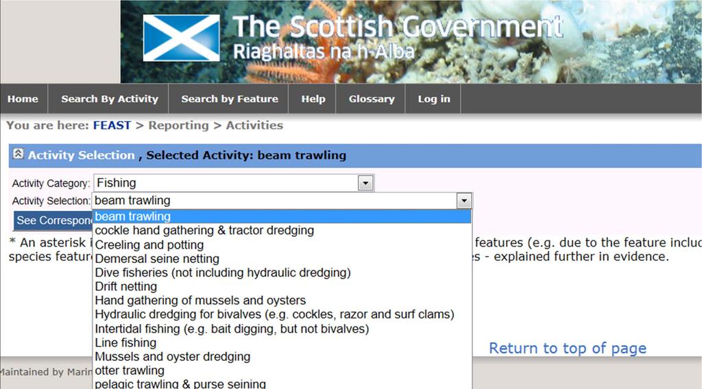
9 Scottish Natural Heritage Search by Activity


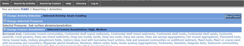
10 Scottish Natural Heritage

11 Search by Feature
12 Pressure Scottish Natural Heritage Electromagnetic changes Nitrogen & phosphorus enrichment Non-synthetic compound contamination (inc. heavy metals, hydrocarbons, produced water) Organic enrichment Physical change (to another seabed type) Salinity changes - local Siltation changes (high) Definition Basking shark and common skate only - Local electric field of 1 volt per meter; Local magnetic field of 10 telsa (µt). Compliance with WFD criteria for good status. Ideally, the pressure would be assessed in terms of increases in nutrient loading over background. However, such information is not readily available. As a surrogate it could be possible to use information from WFD and CEMP assessments in relation to winter concentrations of DIN (a measure of state) and compare these to WFD standards and status classification outputs. Note: Closely linked with Deoxygenation pressure. Compliance with all AA EQS, conformance with PELs, EACs/ER-Ls. Water column annual average (AA) environmental quality standards (EQS) provide high levels of protection for all living organisms. Canadian interim sediment quality guidelines (ISQG) Probable Effects Levels (PELs) provide an indication of sediment risks. OSPAR Environmental Assessment Criteria (EACs) and Effects Range- Low (ER-Ls) criteria provide guidelines for sediment risks. There are also some OSPAR EACs for biota. A deposit of 100gC/m2/yr. This pressure is referring to particulate organic matter and is therefore closely associated with the Siltation pressures. Dissolved organic matter is not covered directly by other pressures, but N and P enrichment pressure addresses the key enrichment factors. The permanent change of one marine habitat type to another marine habitat type, through the change in substratum. For instance a change from sediment to solid substrate including artificial (e.g. concrete mattresses, rock dumping, and moorings), or from one type of sediment to another. This pressure concerns disposal or the deposit of material, whilst the removal of material is covered under abrasion pressures. Increase from 35 to 38 units for one year or Decrease in salinity by 4-10 units for a year 30cm of fine material added to the seabed in a single event or the deposition of fine material over the lifetime of the development.
13 Pressure Definition Scottish Natural Heritage Siltation changes (low) 5cm of fine material added to the seabed in a single event, or the deposition of fine material over the lifetime of the development. Sub-surface abrasion/penetration: Surface abrasion Synthetic compound contamination (inc. pesticides, antifoulants, pharmaceuticals) Underwater noise Water clarity changes Damage to species living within the seabed. For geological/geomorphological features, the pressure relates to the indirect removal of surface sediment via accelerated flow (e.g. from scour around foundations or from propeller jets) or penetration by structures/equipment (e.g. fishing gear) Damage to species living on the seabed or damage to geological and geomorphological structures at the seabed surface "Compliance with all AA EQS, conformance with PELs, EACs, ER-Ls. Water column annual average (AA) environmental quality standards (EQS) provide high levels of protection for all living organisms. Canadian interim sediment quality guidelines (ISQG) Probable Effects Levels (PELs) provide an indication of sediment risks. OSPAR Environmental Assessment Criteria (EACs) and Effects Range- Low (ER-Ls) criteria provide guidelines for sediment risks. There are also some OSPAR EACs for biota. Marine Strategy Framework Directive indicator levels (Sound Exposure Level or peak Sound Pulse Level) exceeded for 20% of days in calendar year within site A change in one rank on the WFD scale, e.g. from clear to turbid for one year (ranks are mean suspended particulate matter in units of mg/c: >300 - very turbid; medium turbidity; intermediate; <10 - clear.)
14 Other sensitivity assessments MarLIN recently updated sensitivity assessments and now uses the same methodology. Marine Evidence based Sensitivity Assessment (MarESA) approach Evidence updated Differences in features assessed (biotope groups, PMFs, FOCI) NE Advice on Operations - Methodology different Sensitive/Not sensitive Mobile features- using a more precautionary combination of tolerance and recovery and separate supporting habitat matrix. FAP (Feature Activity Pressure) matrix JNCC SAP Interagency group on Sensitivities, Activities and Pressure Pressures- Activities Database online (DEFRA project) FAP offshore matrix
Crustose algae communities on Baltic infralittoral rock and mixed substrata
 European Red List of Habitats Marine: Baltic Habitat Group Crustose algae communities on Baltic infralittoral rock and mixed substrata Summary This benthic habitat is present throughout the Baltic where
Mapping of marine habitats in shallow coastal areas in Denmark
 6 th Workshop Seabed Acoustics, Rostock, November 14/15, 2013 P11-1 Mapping of marine habitats in shallow coastal areas in Denmark Dr. Zyad Al-Hamdani Geological Survey of Denmark and Greenland - GEUS
HELSINKI COMMISSION Baltic Marine Environment Protection Commission
 HELSINKI COMMISSION Baltic Marine Environment Protection Commission HELCOM RECOMMENDATION 24/10 Adopted 25 June 2003, having regard to Article 20, Paragraph 1 b) of the 1992 Helsinki Convention IMPLEMENTATION
Identifying species and ecosystem sensitivities. Appendix 9. Species biology and sensitivity key information pro forma. (September 1999 onwards)
") Appendix 9. Species biology and sensitivity key information pro forma. (September 1999 onwards) Scientific name (Authority and Date) Common name(s) 4. Date last updated 5. MCS / Ulster Museum species code
Appendix 9. Species biology and sensitivity key information pro forma. (September 1999 onwards) Scientific name (Authority and Date) Common name(s) 4. Date last updated 5. MCS / Ulster Museum species code
Why Erosion and Sedimention Control is Important: A Fish s Point of View
 Why Erosion and Sedimention Control is Important: A Fish s Point of View Fisheries Protection Program Department of Fisheries and Oceans June 6, 2014 Basic definition: Sediment is defined as soil particles
HELCOM-VASAB Maritime Spatial Planning Working Group Twelfth Meeting Gdansk, Poland, February 2016
 HELCOM-VASAB Maritime Spatial Planning Working Group Twelfth Meeting Gdansk, Poland, 24-25 February 2016 Document title HELCOM database for the coastal and marine Baltic Sea protected areas (HELCOM MPAs).
Annual algae communities on Baltic infralittoral coarse sediment
 European Red List of Habitats Marine: Baltic Sea Habitat Group Annual algae communities on Baltic infralittoral coarse sediment Summary This habitat is found in all the Baltic Sea subbasins and is especially
v=7tat9croynk&feature=youtu.be
 https://www.youtube.com/watch? v=7tat9croynk&feature=youtu.be Malta Summer School 2018 Operational Oceanography for Blue Growth EMODnet in a nutshell: unlocking, and offering access to, European marine
Seabed Habitat Classification Issues Jacques Populus - Ifremer - Brest
 Seabed Habitat Classification Issues Jacques Populus - Ifremer - Brest Classifications of nature types are necessary to provide an explicit view of the seabed on maps, however they are only an imperfect
Natural Susceptibility to Coastal Erosion: Methodology and Mapping Summary
 Natural Susceptibility to Coastal Erosion: Methodology and Mapping Summary. Introduction The Flood Risk Management (Scotland) Act 2009 (FRM Act) introduced a coordinated and partnership approach to how
Dam Removal Analysis Guidelines for Sediment
 A review of: Dam Removal Analysis Guidelines for Sediment Joe Rathbun (Retired) rathbunj@sbcglobal.net Some Potential Sediment Issues Reservoir restoration Downstream water quality Downstream deposition
National Marine Sanctuary Program
 National Marine Sanctuary Program NMSP/USGS Joint Seabed Mapping Initiative: September 2004 AA National Ocean Service National Marine Sanctuaries Interim Report September 2004 Background: Since 2002,
Unvegetated epifaunal communities on Baltic infralittoral coarse sediment
 European Red List of Habitats Marine: Baltic Habitat Group Unvegetated epifaunal communities on Baltic infralittoral coarse sediment Summary This habitat occurs in all the Baltic Sea subbasins although
Data and data product catalogue. Preliminary version May 2018
 Data and data product catalogue Preliminary version May 2018 This document has been produced by the EMODnet Secretariat. All the maps have been extracted from the EMODnet thematic portals. Data Data products
Geospatial Decision Support Tools for Planning of Marine Protected Areas in California
 Geospatial Decision Support Tools for Planning of Marine Protected Areas in California WILL MCCLINTOCK (UNIVERSITY OF CALIFORNIA SANTA BARBARA), MATT MERRIFIELD (THE NATURE CONSERVANCY), SOPHIE DE BEUKELAER
The HELCOM Baltic Sea Action Plan and Marine Spatial Planning
 The HELCOM Baltic Sea Action Plan and Marine Spatial Planning Anne Christine Brusendorff Executive Secretary HELCOM The Baltic Sea Our common responsibility. Workshop on Integrated Sea Use management Stockholm
Scottish MPA Project Data confidence assessment SHIANT EAST BANK MPA PROPOSAL
 Scottish MPA Project Data confidence assessment SHIANT EAST BANK MPA PROPOSAL Document version control Version Date Author Reason / Comments Version 1 29/01/2014 Laura Clark Revised MPA proposal format,
Seagrass Transplantation & Environmental & Marine Consulting Services, Inc. Drew Campbell, Vice President & Lead Scientst.
 Indian River Lagoon Symposium Seagrass Transplantation & Project Considerations Environmental & Marine Consulting Services, Inc. Drew Campbell, Vice President & Lead Scientst March 26 th, 2013 Regulatory
Scottish MPA Project Data confidence assessment SMALL ISLES POSSIBLE NATURE CONSERVATION MPA
 Scottish MPA Project Data confidence assessment SMALL ISLES POSSIBLE NATURE CONSERVATION MPA Document version control Version Date Author Reason / Comments Version 1 07/09/2012 Ben James, Laura Clark and
Using seascapes to help predict Australia s benthic marine habitat diversity in the development of a national system of marine protected areas
 Using seascapes to help predict Australia s benthic marine habitat diversity in the development of a national system of marine protected areas A.D. Heap 1, T. Whiteway 1, V. Lucieer 2, S. Nichol 1 1. Geoscience
Sediment and biota monitoring of an offshore dredged material disposal site in the German Bight
 Sediment and biota monitoring of an offshore dredged material disposal site in the German ight Assessment by means of the OSPAR-criteria Uwe Hentschke 1, Sabine Schäfer 1, irgit Schubert 1 Maja Karrasch
Multi-sector biodiversity surveys: integrating federal, territorial and community-based surveys. Kevin J. Hedges
 Multi-sector biodiversity surveys: integrating federal, territorial and community-based surveys Kevin J. Hedges Outline Study area Research/stakeholder groups Recent integration Eastern Canadian Arctic
Mapping ecosystem services provided by benthic habitats in the European Atlantic Ocean
 Mapping and Assessment Ecosystem Services and Links to Good Environmental Status Mapping ecosystem services provided by benthic habitats in the European Atlantic Ocean Ibon Galparsoro, Angel Borja and
Higher National Unit specification. General information for centres. Geology and Geomorphology. Unit title: Unit code: F3SL 34
 Higher National Unit specification General information for centres Unit title: Geology and Geomorphology Unit code: F3SL 34 Unit purpose: This Unit provides an introduction to geology and geomorphology.
Exploitation of Ocean Predictions by the Oil and Gas Industry. GODAE OceanView Symposium 2013
 Exploitation of Ocean Predictions by the Oil and Gas Industry GODAE OceanView Symposium 2013 Introduction Information needs Challenges Acknowledgements IMarEST/SUT Metocean Awareness Course Colleagues
Technical Review of Pak Beng Hydropower Project (1) Hydrology & Hydraulics and (2) Sediment Transport & River Morphology
 Hydrology & Hydraulics and (2) Sediment Transport & River Morphology") Technical Review of Pak Beng Hydropower Project (1) Hydrology & Hydraulics and (2) Sediment Transport & River Morphology The 2 nd Regional Stakeholder Forum The Pak Beng Hydropower Project 5 th May 2017
Technical Review of Pak Beng Hydropower Project (1) Hydrology & Hydraulics and (2) Sediment Transport & River Morphology The 2 nd Regional Stakeholder Forum The Pak Beng Hydropower Project 5 th May 2017
Flood Risk Mapping and Forecasting in England
 Flood Risk Mapping and Forecasting in England Mark Franklin Environment Agency, England NORDESS Workshop on Risk Assessment and Acceptable Risk Outline Flood risk in England Who we are and how we work
Findings and recommendations from Central Baltic case
 W 1/1 Recommendations on transboundary planning from Baltic SCOPE Findings and recommendations from Central Baltic case Ingūna Urtāne Director of Spatial Planning Department of the Ministry of Environmental
Infaunal communities in Baltic infralittoral muddy sediment not dominated by bivalves
 European Red List of Habitats Marine: Baltic Habitat Group Infaunal communities in Baltic infralittoral muddy sediment not dominated by bivalves Summary This habitat occurs in shallow areas in all the
ABP Southampton. Environmental Statement for Port of Southampton: Berth 201/202 Works. Appendix K. Recommended Marine Conservation Zone Assessment
 ABP Southampton Environmental Statement for Port of Southampton: Berth 201/202 Works Appendix K Recommended Marine Conservation Zone Assessment Appendix K Berth 201/202 Works Potential Impact on Recommended
Mobrand to Jones and Stokes. Sustainable Fisheries Management Use of EDT
 Sustainable Fisheries Management Use of EDT Ecosystem Diagnosis and Treatment EDT EDT designed to provide a practical, science-based approach for developing and implementing watershed plans. Provides decision
Designing Networks of Marine Protected Areas in DFO s Three Atlantic Bioregions
 Designing Networks of Marine Protected Areas in DFO s Three Atlantic Bioregions Presentation for Indigenous Protected Areas Workshop Max Westhead, DFO and Adrian Gerhartz-Abraham, Dalhousie March 29, 2017
Significant Ecological Marine Area Assessment Sheet
 Significant Ecological arine Area Assessment Sheet Name: Eastern Bay of Island Biogenic Soft Sediment Complex Summary: The semi-sheltered areas between the central islands of the Eastern Bay of Islands
Impact of Noise on the Marine Environment a Regulatory Perspective
 Impact of Noise on the Marine Environment a Regulatory Perspective John Hartley Hartley Anderson Ltd. Photographs courtesy of JNCC Over-arching Objective Minimise the Impact of Oil and Gas Activities &
Relatively little hard substrate occurs naturally in the
 CHAPTER FIVE Rock Habitats Relatively little hard substrate occurs naturally in the estuary, owing mainly to the vast quantities of fine sediment that have been deposited by the rivers. Rock habitat is
BalticBOOST Appendix 1, WP 3.3 Deliverable 1 Final report 14 February 2017
 Theme 1: Biodiversity This is a deliverable from the BalticBOOST project that was coordinated by HELCOM and co-financed by the European Union in 2015-2016 as part of the programme DG ENV/MSFD Action Plans/2016.
OSPAR CONVENTION FOR THE PROTECTION OF THE MARINE ENVIRONMENT OF THE NORTH-EAST ATLANTIC
 OSPAR CONVENTION FOR THE PROTECTION OF THE MARINE ENVIRONMENT OF THE NORTH-EAST ATLANTIC GUIDANCE ON DEVELOPING AN ECOLOGICALLY COHERENT NETWORK OF OSPAR MARINE PROTECTED AREAS (Reference number 2006-3)
working today for nature tomorrow The practical implementation of marine spatial planning - understanding and addressing cumulative effects
 Report Number 599 The practical implementation of marine spatial planning - understanding and addressing cumulative effects English Nature Research Reports working today for nature tomorrow English Nature
Mapping of marine ecosystems and their services in the Bulgarian Black Sea region. Evaluation of current condition
 Mapping of marine ecosystems and their services in the Bulgarian Black Sea region. Evaluation of current condition V. Karamfilov, D. Berov, V. Biserkov, G. Daskalov, S. Klayn,Y. Biserkov- IBER-BAS V. Todorova,
The Imperative of Sediment Management Concepts in River Basin Management Plans
 The Imperative of Sediment Management Concepts in River Basin Management Plans Stefan Vollmer, Thomas Hoffmann, Gudrun Hillebrand, Ina Quick, Axel Winterscheid Department M3 Groundwater, Geology, River
Subcommittee on Sedimentation Draft Sediment Analysis Guidelines for Dam Removal
 Subcommittee on Sedimentation Draft Sediment Analysis Guidelines for Dam Removal August 4, 2011 Jennifer Bountry, M.S., P.E. Tim Randle, M.S., P.E., D.WRE. Blair Greimann, Ph.D., P.E. Sedimentation and
Dynamic Coast. Coastal erosion / Management Briefing to THC
 Dynamic Coast Coastal erosion / Management Briefing to THC What is Dynamic Coast? Dynamic Coast is a Scottish Government project, funded by CREW, managed by SNH, with a research team from the University
GIS-Based Sediment Quality Database for the St. Louis River Area of Concern (AOC): Overview Presentations and Demonstration
: Overview Presentations and Demonstration") GIS-Based Sediment Quality Database for the St. Louis River Area of Concern (AOC): Overview Presentations and Demonstration Judy L. Crane 1 and Dawn E. Smorong 2 1 Minnesota Pollution Control Agency, St.
GIS-Based Sediment Quality Database for the St. Louis River Area of Concern (AOC): Overview Presentations and Demonstration Judy L. Crane 1 and Dawn E. Smorong 2 1 Minnesota Pollution Control Agency, St.
Mapping and Assessment of Ecosystems and their Services
 Mapping and Assessment of Ecosystems and their Services ALTER-Net Conference 2013: Science underpinning the EU 2020 Biodiversity Strategy. April 2013 Gent Joachim MAES 1 This presentation is based on the
DFO Maritimes Region Update. Gulf of Maine Council - Coastal and Marine Spatial Planning (CMSP) Committee Web-Ex May 16, 2017
 Committee Web-Ex May 16, 2017") DFO Maritimes Region Update Gulf of Maine Council - Coastal and Marine Spatial Planning (CMSP) Committee Web-Ex May 16, 2017 1 National Oceans Priorities Marine Conservation Targets Oceans Protection Plan
DFO Maritimes Region Update Gulf of Maine Council - Coastal and Marine Spatial Planning (CMSP) Committee Web-Ex May 16, 2017 1 National Oceans Priorities Marine Conservation Targets Oceans Protection Plan
Rapid Geomorphic Assessments: RGA s
 Establishing Current Reference Conditions Rates and concentrations of suspended-sediment transport vary over time and space due to factors such as precipitation characteristics and discharge, geology,
Use of benthic invertebrate biological indicators in evaluating sediment deposition impairment on the Middle Truckee River, California
 Use of benthic invertebrate biological indicators in evaluating sediment deposition impairment on the Middle Truckee River, California David B. Herbst Sierra Nevada Aquatic Research Laboratory University
low turbidity high turbidity
 What is Turbidity? Turbidity refers to how clear the water is. The greater the amount of total suspended solids (TSS) in the water, the murkier it appears and the higher the measured turbidity. Excessive
Capturing a Holistic Understanding of a Large Marine Ecosystem The NOAA Gulf of Mexico Data Atlas
 Capturing a Holistic Understanding of a Large Marine Ecosystem The NOAA Gulf of Mexico Data Atlas NODC / National Coastal Data Development Center gulfalas.noaa.gov Need: data that contribute to long-term
June 2018 Sediments and Dredging at GBR Ports
 June 2018 Sediments and Dredging at GBR Ports Reef 2050 Long Term Sustainability Plan The Great Barrier Reef is over 2000 km long and covers an area of approximately 350,000 square kilometres. It is a
Dynamic preservation of the coastline
 Dynamic preservation of the coastline Content Introduction The Dutch coastal defence by dynamic processes Data collection Management of the sand resources Growing importance of marine sand and gravel resources
Key Indicators for Territorial Cohesion & Spatial Planning Stakeholder Workshop - Project Update. 13 th December 2012 San Sebastián, Basque Country
 Key Indicators for Territorial Cohesion & Spatial Planning Stakeholder Workshop - Project Update 13 th December 2012 San Sebastián, Basque Country Key Aims Explore the use of territorial data in developing
HydroSpatial II Practical application of INSPIRE in Marine Mapping Data
 HydroSpatial II Practical application of INSPIRE in Marine Mapping Data INSPIRE Conference 30 th June 2011 Carlos Berná Esteban, GIS Analyst, SeaZone carlos.berna-esteban@seazone.com Overview HydroSpatial
CNSC Review of the Long-Term Safety Case for a Deep Geologic Repository
 CNSC Review of the Long-Term Safety Case for a Deep Geologic Repository T. Son Nguyen Geoscience Specialist Brugg, Switzerland May 13, 2016 e-doc 4972224 nuclearsafety.gc.ca Content Ontario Power Generation
Infaunal communities of Baltic upper circalittoral sand not dominated by bivalves
 European Red List of Habitats Marine: Baltic Habitat Group Infaunal communities of Baltic upper circalittoral sand not dominated by bivalves Summary This habitat is typical of upper circalittoral sand
Economic Valuation of the Montego Bay Marine Park
 Economic Valuation of the Montego Bay Marine Park Methodology Test Cases Presenter: Brian L. Zane What? A means to estimate the value of environmental resources How? Different methodologies exist Total
Natura 2000 in the marine environment: state of implementation and next steps
 Life on the blue planet: biodiversity research and the new European marine policies EPBRS European Platform on Biodiversity Research Strategy Porto, Portugal 7-9 November 2007 Natura 2000 in the marine
Environmental impact assessment study of the new offshore dumping sites for Šventoji port in Lithuania
 Environmental impact assessment study of the new offshore dumping sites for Šventoji port in Lithuania Introduction Summary In 2003 Lithuanian Ministry of Transport initiated the preparation of feasibility
Annual transport rates at two locations on the fore-slope.
 Sediment Transport by Currents Fore-slope Sediment transport rates and sediment concentrations were computed from the hydrodynamic model runs as well as from direct measurements of current velocities at
MEMORANDUM OF UNDERSTANDING ON THE CONSERVATION OF MIGRATORY SHARKS HABITAT CONSERVATION. (Prepared by the Advisory Committee)
") MEMORANDUM OF UNDERSTANDING ON THE CONSERVATION OF MIGRATORY SHARKS CMS/Sharks/MOS3/Doc.10.2 24 August 2018 Original: English 3 rd Meeting of the Signatories (Sharks MOS3) Monaco, 10 14 December 2018 Agenda
MEMORANDUM OF UNDERSTANDING ON THE CONSERVATION OF MIGRATORY SHARKS CMS/Sharks/MOS3/Doc.10.2 24 August 2018 Original: English 3 rd Meeting of the Signatories (Sharks MOS3) Monaco, 10 14 December 2018 Agenda
Page 7 1 NON-TECHNICAL SUMMARY
 Page 7 1 NON-TECHNICAL SUMMARY This section provides a non-technical summary of the Environmental Impact Assessment (EIA) for Shell and its Consortium partners shallow coring program proposed to occur
Evolution and Life in the Ocean
 Characteristics of All Living Things Contain matter in a highly organized state Capture, store and transmit energy; all organisms require energy Capable of reproduction Change through time and adapt to
Providing Marine Data. The German Marine Data Infrastructure (MDI-DE) as an example for best practice
 as an example for best practice") Providing Marine Data The German Marine Data Infrastructure (MDI-DE) as an example for best practice Data Originators 18 Agencies and Institutions in the EEZ and 12 Mile Zone Federal Government BSH Schleswig-Holstein
Providing Marine Data The German Marine Data Infrastructure (MDI-DE) as an example for best practice Data Originators 18 Agencies and Institutions in the EEZ and 12 Mile Zone Federal Government BSH Schleswig-Holstein
Appendix G.19 Hatch Report Pacific NorthWest LNG Lelu Island LNG Maintenance Dredging at the Materials Offloading Facility
 Appendix G.19 Hatch Report Pacific NorthWest LNG Lelu Island LNG Maintenance Dredging at the Materials Offloading Facility Project Memo H345670 To: Capt. David Kyle From: O. Sayao/L. Absalonsen December
Marine/Maritime Spatial Planning Andrej Abramić
 Marine/Maritime Spatial Planning Andrej Abramić EcoAqua SUMMER SCHOOL: Ecosystem approach to aquaculture 26-29th of October 2015 Research and Technology to enhance excellence in Aquaculture development
Implementation of the Political Declaration on energy cooperation between the North Seas Countries. Support Group 1 on Maritime Spatial Planning
 Implementation of the Political Declaration on energy cooperation between the North Seas Countries Support Group 1 on Maritime Spatial Planning Work Programme 1. Work area as outlined in Annex I to the
Scottish MPA Project Data confidence assessment SOUTHERN TRENCH MPA PROPOSAL
 Scottish MPA Project Data confidence assessment SOUTHERN TRENCH MPA PROPOSAL Document version control Version Date Author Reason / Comments Version 1 29/01/2014 Laura Clark Revised MPA proposal format,
Management of Sediment Quality and Quantity in the Danube River Basin
 Management of Sediment Quality and Quantity in the Danube River Basin 5 th SedNet Conference 27-29 May 2008 Oslo (N) Igor Liska ICPDR igor.liska@unvienna.org CONTENT ICPDR & EU WFD implementation Sediment
Introduction: The Gulf of Mexico Alliance. The Gulf GAME project MERMAid and PHINS Results & Conclusions What s next? Examples
 AAG Las Vegas March 25, 2009 Introduction: Ocean governance and Ecosystem-Based Management The Gulf of Mexico Alliance Habitat Identification and Characterization The Gulf GAME project MERMAid and PHINS
The Problem. Which ecosystems are the most sensitive? Where will ecosystems be migrating? Where will investments be overwhelmed?
 BC Parks BC Parks is responsible for the designation, management and conservation of a system of ecological reserves, provincial parks and recreation areas located throughout the province. British Columbia
Marine Spatial Planning, a Norwegian user case NSHC33
 Marine Spatial Planning, a Norwegian user case NSHC33 Marine Spatial Management Tool Support the marine spatial planning process with updated and reliable geospatial information Marine management is important
Scottish MPA Project Data confidence assessment SOUTH ARRAN POSSIBLE NATURE CONSERVATION MPA
 Scottish MPA Project Data confidence assessment SOUTH ARRAN POSSIBLE NATURE CONSERVATION MPA Document version control Version Date Author Reason / Comments Version 1 02/10/2012 Ben James and Laura Clark
Spatial Decision-Support for National Marine Conservation Areas in the Southern Strait of Georgia and Gwaii Haanas
 Spatial Decision-Support for National Marine Conservation Areas in the Southern Strait of Georgia and Gwaii Haanas Lindsay McBlane Krista Royle Greg MacMillan Photo: Mark Hiebert Western and Northern Service
ACRONYMS AREAS COUNTRIES MARINE TERMS
 Natura 2000 ACRONYMS AREAS COUNTRIES MARINE TERMS DEFINITION A European network of protected sites under the European Habitats and Birds Directives, aiming to protect the most valuable and threatened European
Report from the SedNet Round Table Discussion November Sediment Management an essential element of River Basin Management Plans
 Report from the SedNet Round Table Discussion 22-23 November 2006 Sediment Management an essential element of River Basin Management Plans Piet den Besten, Steering Group SedNet Objectives WFD River Basin
MESMA: An integrated tool box to support an ecosystem based spatial management of marine areas
 MESMA: An integrated tool box to support an ecosystem based spatial management of marine areas Stelzenmüller, V., Stamford, T., Vassilopoulou, V., Kastanevakis, S., Vincx, M, Vanaverbeke, J., Rabaut, M.,
EMODnet data. Flanders Marine Institute. Simon Claus. A. Giorgetti, D. Schaap, A. Novellino, A. Pititto, H.Lilis, V. Henry, T.
 EMODnet data Simon Claus A. Giorgetti, D. Schaap, A. Novellino, A. Pititto, H.Lilis, V. Henry, T. Schmitt Flanders Marine Institute EMODnet data themes Types of Data Vocabularies Data Exchange Format Metadata
Food for thoughts. Jon Davies MESH Project Coordinator
 Food for thoughts Jon Davies MESH Project Coordinator You are not alone.. There is someone out there.. Habmap UKSeaMap MESH Why is he here? Introduce the MESH Project, give a brief overview of other marine
Spatial Planning in Canada s Maritimes Region. Maritimes Region
 Spatial Planning in Canada s Maritimes Region Glen Herbert, Scott Coffen-Smout Smout,, and Tanya Koropatnick Oceans and Coastal Management Division Ecosystem Management Branch Fisheries and Oceans Canada
MERSEA Marine Environment and Security for the European Area
 MERSEA Marine Environment and Security for the European Area Development of a European system for operational monitoring and forecasting of the ocean physics, biogeochemistry, and ecosystems, on global
Non-Technical Summary
 Non-Technical Summary Proposed Project TGS-NOPEC Geophysical Company ASA (TGS) proposes to undertake a two dimensional (2D) seismic survey and seabed sampling in the western Greenland Sea off North East
Marine Spatial Planning (MSP): A practical approach to ecosystembased
: A practical approach to ecosystembased") Marine Spatial Planning (MSP): A practical approach to ecosystembased management Erik Olsen, Institute of Marine Research, Norway Fanny Douvere, International Oceanographic Commission Overview Why we need
Marine Spatial Planning (MSP): A practical approach to ecosystembased management Erik Olsen, Institute of Marine Research, Norway Fanny Douvere, International Oceanographic Commission Overview Why we need
Mapping intertidal sediment distributions using the RoxAnn System, Dornoch Firth, NE Scotland
 Mapping intertidal sediment distributions using the RoxAnn System, Dornoch Firth, NE Scotland J. HULL & R. NUNNY Ambios Environmental Consultants Ltd, The Ferns, Kilkenny Ave, Taunton, Somerset TA2 7P
BCGQ Mission Statement. Acquire new geoscientific knowledge in Québec within a sustainable development perspective of our mineral resources.
 BCGQ Mission Statement Acquire new geoscientific knowledge in Québec within a sustainable development perspective of our mineral resources. Financial Resources Natural Resources Fund, Mining Heritage Section
The European Marine Observation and Data Network. EU-China Blue Year Event 1 June,
 The European Marine Observation and Data Network EU-China Blue Year Event 1 June, 2017 secretariat@emodnet.eu info@emodnet.eu There is only one Earth, with only one history, and we get only one chance
MUDMAP TM. Software Description
 ASA Applied Science Associates, Inc. 70 Dean Knauss Drive Narragansett, RI 02882-1143 U.S.A. Tel: 401-789-6224 Fax: 401-789-1932 asa@asascience.com www.asascience.com MUDMAP TM Software Description MUDMAP
Coastal Environment. Introduction. 4.1 Coastal Environment. Extent of Coastal Environment
 4 The primary objective (set out in Chapter 2) to be implemented by this Chapter is Objective 2.4 ; the following objectives are also relevant due to the objectives integrated nature: 2.1 Tāngata whenua
Picture: Nigel Keeley. SustainAqua. Sustainable aquaculture in the North identifying thresholds, indicators and tools for future growth
 Picture: Nigel Keeley SustainAqua Sustainable aquaculture in the North identifying thresholds, indicators and tools for future growth 4 årigt forskningsråds prosjekt Norway International Raymond Bannister
Opportunities to Improve Ecological Functions of Floodplains and Reduce Flood Risk along Major Rivers in the Puget Sound Basin
 Opportunities to Improve Ecological Functions of Floodplains and Reduce Flood Risk along Major Rivers in the Puget Sound Basin Christopher Konrad, US Geological Survey Tim Beechie, NOAA Fisheries Managing
BEFORE THE ENVIRONMENTAL PROTECTION AUTHORITY AT WELLINGTON
 BEFORE THE ENVIRONMENTAL PROTECTION AUTHORITY AT WELLINGTON IN THE MATTER of the Exclusive Economic Zone and Continental Shelf (Environmental Effects) Act 2012 (EEZ Act) AND IN THE MATTER BETWEEN AND AND
15 March 2010 Re: Draft Native Vegetation of the Sydney Metropolitan Catchment Management Authority Area GIS layers and explanatory reports
 SYDNEY COASTAL COUNCILS GROUP Inc. C/- City of Sydney Council Level 14, 456 Kent Street GPO Box 1591, SYDNEY NSW 2001 Phone: (02) 9246 7791 Facsimile: (02) 9265 9660 Email: info@sydneycoastalcouncils.com.au
Texas A & M University and U.S. Bureau of Reclamation Hydrologic Modeling Inventory Model Description Form
 Texas A & M University and U.S. Bureau of Reclamation Hydrologic Modeling Inventory Model Description Form JUNE, 1999 Name of Model: Two-Dimensional Alluvial River and Floodplain Model (MIKE21 CHD & CST)
SPLAN-Natura Towards an integrated spatial planning approach for Natura th January, 2017 Brussels. Commissioned by DG Environment
 SPLAN-Natura 2000 Towards an integrated spatial planning approach for Natura 2000 Commissioned by DG Environment 17 th January, 2017 Brussels V. Simeonova (Ph.D.) Drivers towards integrating Biodiversity
Watershed Assessment of River Stability and Sediment Supply: Advancing the Science of Watershed Analysis
 Watershed Assessment of River Stability and Sediment Supply: Advancing the Science of Watershed Analysis 2009 MWEA Annual Conference Rob Myllyoja, CET rmyllyoja@hrc-engr.com Watershed Assessment of River
Best Management Practices for Coldwater Fisheries Enhancement and Restoration
 Best Management Practices for Coldwater Fisheries Enhancement and Restoration MACC Annual Environmental Conference 2017 March 3, 2017 Tim Dexter, MassDOT Highway Division 1 Leading the Nation in Transportation
The Governance of Land Use
 The planning system The Governance of Land Use United Kingdom Levels of government and their responsibilities The United Kingdom is a unitary state with three devolved governments in Northern Ireland,
Introduction. Ecology is the scientific study of the interactions between organisms and their environment.
 Introduction Ecology is the scientific study of the interactions between organisms and their environment. 1. The interactions between organisms and their environments determine the distribution and abundance
A TOOLKIT FOR MARINE SPATIAL PLANNING Version: 17 July, 2009
 A TOOLKIT FOR MARINE SPATIAL PLANNING Version: 17 July, 2009 NEED FOR MARINE SPATIAL PLANNING The health of marine ecosystems is declining, and use conflicts in the marine environment are increasing, in
STORM IMPACT MODELING ANALYSIS FOR THE RESTORATION OF GULF STATE PARK, AL
 STORM IMPACT MODELING ANALYSIS FOR THE RESTORATION OF GULF STATE PARK, AL Jordon Cheifet, PE, CFM Joao Dobrochinski, MSc Morjana Signorin APTIM Senior Project Engineer APTIM Numerical Modeling Lead APTIM
OSPAR request on the production of spatial data layers of fishing intensity/pressure
 ICES Technical Service Published 25 August 2017 OSPAR request on the production of spatial data layers of fishing intensity/pressure Service summary ICES Secretariat has collected relevant VMS and logbook