A hydro-sedimentological view of the Samarco disaster, focusing in the Rio Doce estuary and adjacent coastal zone
|
|
|
- Marcia Robinson
- 6 years ago
- Views:
Transcription

1 A hydro-sedimentological view of the Samarco disaster, focusing in the Rio Doce estuary and adjacent coastal zone Paulo Cesar Colonna Rosman Area of Coastal & Oceanographic Engineering Depart. Water Resources & Environment Escola Politécnica & COPPE/PEnO UFRJ Places and distances via Google Earth Recommended and ongoing responses Suspended sediments plume passing along the estuary Has the plume reached Abrolhos coral reefs?

2 A hydro-sedimentological view of the Samarco disaster, focusing in the Rio Doce estuary and adjacent coastal zone Samarco dams Places and Distances ~ 670 km from the Samarco dams to the sea ~ 80 km Gualaxo do Norte river ~ 30 km Carmo river ~ 560 km Rio Doce 4 reservoirs in the Rio Doce ~ 215 km from the Rio Doce mouth to Abrolhos


3 A hydro-sedimentological view of the Samarco disaster, focusing in the Rio Doce estuary and adjacent coastal zone Before and After: Dams and Bento Rodrigues District Fundão dam collapsed in 2015.Nov.05 The mud flow from the collapsed dam invaded the Santarém reservoir, and overtopped its dam (no collapse). Estimated overtoping volume = 35 million m³ Area covered by the mud flow before reaching the Gualaxo do Norte river 3.2 million m². ~ 10% of the thicker mud deposited Recommended zone for Bento Rodrigues Memorial Park with reforestation and landscaping
 Destruction of riparian forests and deposits of mud in floodplains and")

4 A hydro-sedimentological view of the Samarco disaster, focusing in the Rio Doce estuary and adjacent coastal zone Before and After: Gualaxo do Norte river (80 km) Destruction of riparian forests and deposits of mud in floodplains and marginal areas Recommended soil correction and reforestation of riparian forests along 2 80 km the Gualaxo do Norte river Impacted area in Gualaxo do Norte river ~ 120 m 80 km 9.5 million m². Mud deposits of ~20% of the original sediment volume


5 A hydro-sedimentological view of the Samarco disaster, focusing in the Rio Doce estuary and adjacent coastal zone Before and After: Gualaxo do Norte Carmo river Carmo river Gualaxo do Norte river Destruction of riparian forests and deposits of mud in floodplains and marginal areas Impacted area in Carmo river ~120 m 34 km 4 million m². Deposits of ~10% of the heavier mud Carmo river Recommended soil correction and reforestation of riparian forests along 2 34 km along the Carmo river

.")
6 A hydro-sedimentological view of the Samarco disaster, focusing in the Rio Doce estuary and adjacent coastal zone Before and After: Rio Doce = Carmo + Piranga rivers Rio Doce Rio Doce has a wider section and suffered no relevant damage in riparian forests, because the passing muddy wave was more fluid, came with a ~40% reduction in sediment volume, and had already been quite dispersed. There was significant deposition of sediments in the reservoirs, especially in the first one, Risoleta Neves (ex-candonga). The biggest reservoir, about of 400 km downstream, is Aimorés
7 A hydro-sedimentological view of the Samarco disaster, focusing in the Rio Doce estuary and adjacent coastal zone Concentrations of Total Suspended Sediment (SST) will remain above normal in the Rio Doce, while: 1. Stocks of fine sediments deposited along the banks of Gualaxo do Norte and Carmo rivers remain available for erosion and keep being washed by rain into the rivers. Therefore, restoration of riparian forests must be done as soon as possible, to lessen availability of erodible sediments. 2. Stocks of accumulated mud in the bottom of the reservoirs of hydroelectric plants keep being flushed downstream during floods. It is recommended to evaluate the convenience of operating the gates in order to allow for scheduled sediment flushes, alleviating need for dredging. Such flushes could transport in a diluted form the deposited sediments, with controllable environmental risks. Dredging of fluid mud is challenging, has low efficiency, and disposal of the dredged material is problematic. Both the option of using large geotextile bags, to filter and retain the sediments, or the option of constructing marginal levees involve environmental challenges and high costs.
8 A hydro-sedimentological view of the Samarco disaster, focusing in the Rio Doce estuary and adjacent coastal zone Recommendations (Dec/2015): Restore the soil as soon as possible to create a Memorial Park where Bento Rodrigues existed. Reforestation with fertilization and soil correction, landscaping and maintenance of Memorial Monuments (Churches, ruins etc.), to retain sediment deposits, mitigating erosion by rain. The Memorial Park would represent an honorable and respectful memory of the victims of the tragedy. Restore as soon as possible the riparian zones of the rivers Gualaxo do Norte and Carmo. Reforestation with fertilization and soil correction designed to retain sediment deposits, mitigating erosion by rain. (Riparian zones of the Rio Doce were mostly unaffected.) Operate the reservoirs in order to provide gradual flushing of the fluid mud deposits, during rainy months.

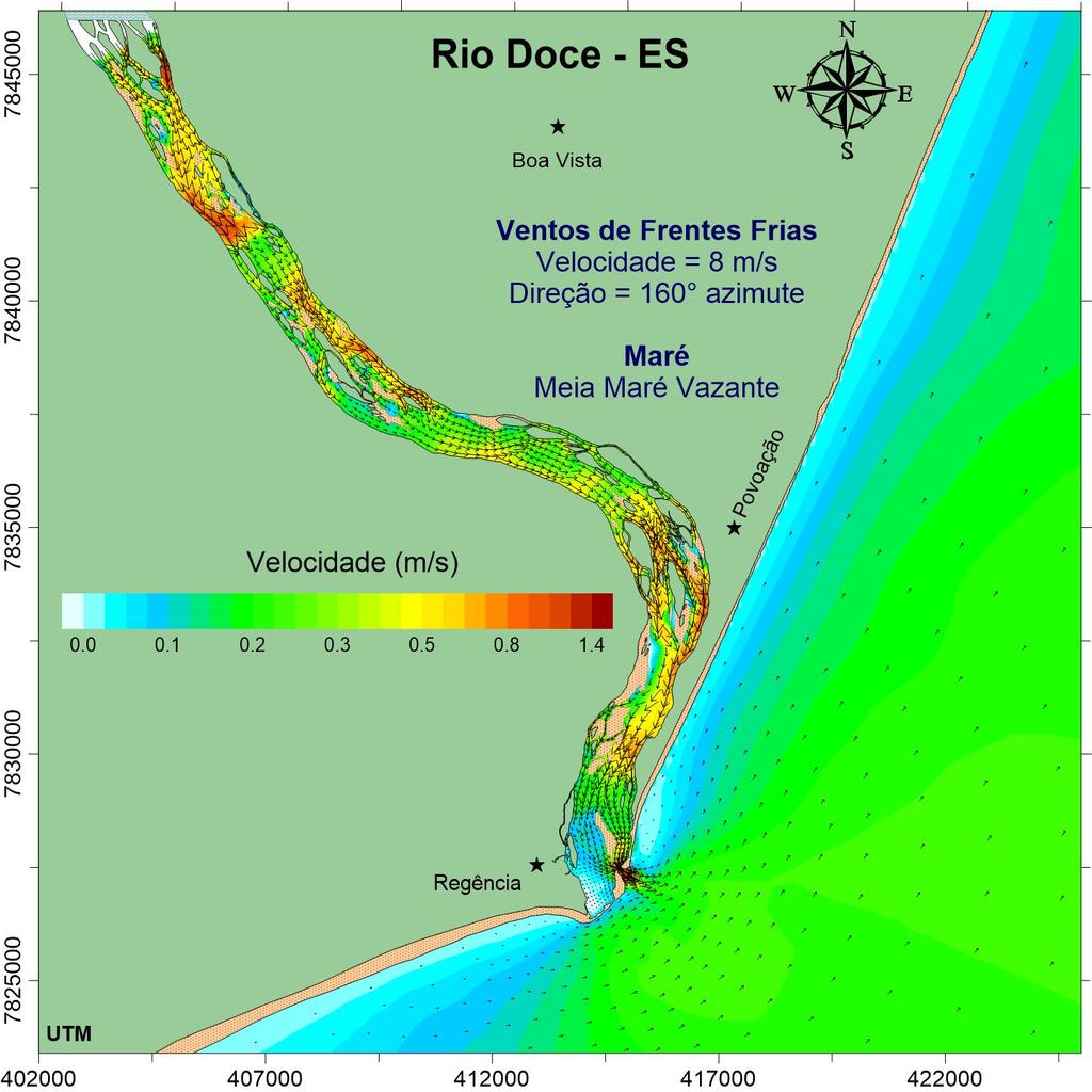
9 Hydro-sedimentological aspects in the Estuarine Region of Rio Doce and adjacent Coastal Zone Technical team: Prof. Paulo Cesar Colonna Rosman D.Sc. Ludmila Assunção Pinheiro M.Sc. Rodrigo dos Santos Peixoto M.Sc. Patricia Auler Rosman Modeling done with SisBaHiA
10 SST (mg/l) Discharge Vazão (m 3 /s) Basic data of Rio Doce: River Discharge and Total Suspended Sediment (SST) Concentration Vazão - Estação Colatina Rio Doce discharge at Colatina, ES (~100 km upstream of the mouth) /11/ /12/ /01/ /02/ /03/2016 Date Tempo (dd/mm/yy) Sólidos Suspensos Totais - Linhares Total Suspended Sediments (SST) at Linhares, ES (~40 km upstream of the mouth) /11/ /12/ /01/ /02/ /03/2016 Date Tempo (dd/mm/yy) Data provided by Vale S.A. Date (dd/mm/yy) Granulometry

11 Tide Nível Elevation (m) (m) Basic data of Rio Doce: Winds and Tides Elevação da Maré Tides in the coastal zone near Rio Doce mouth /11/ /12/ /01/ /02/ /03/ m = IBGE Imbituba Datum Date (dd/mm/yy) Tempo


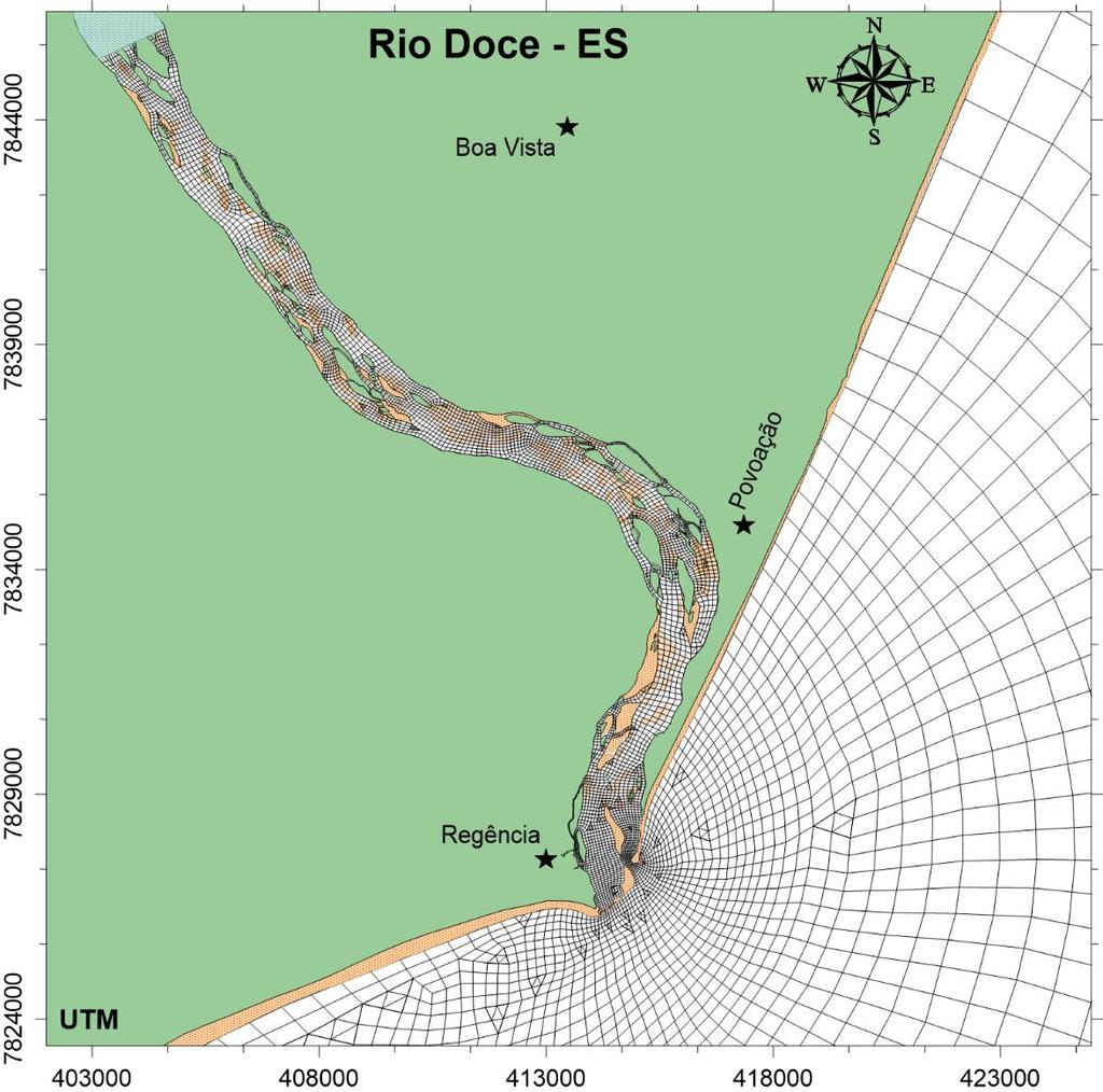
12 Digital Terrain Modeling
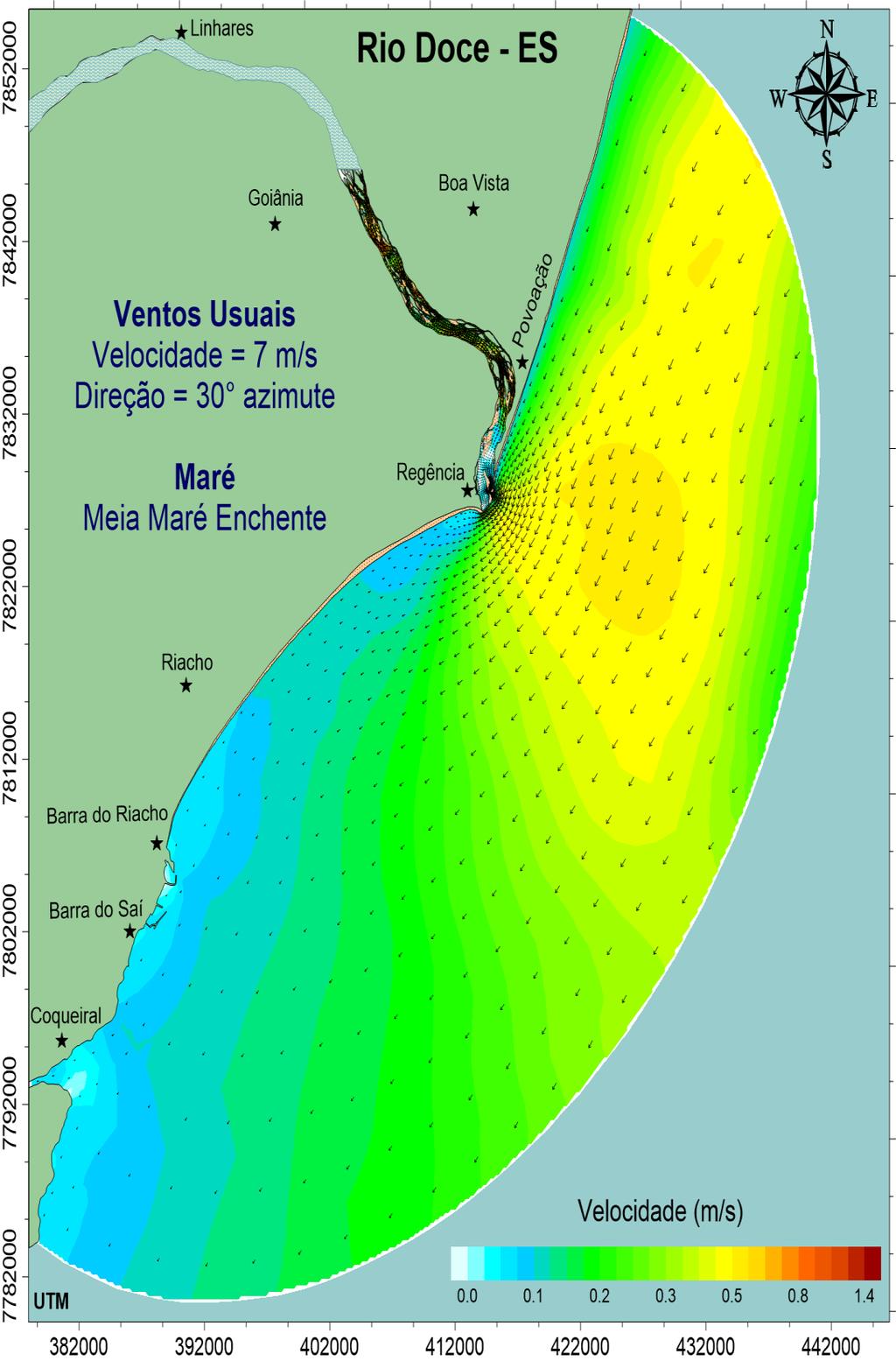
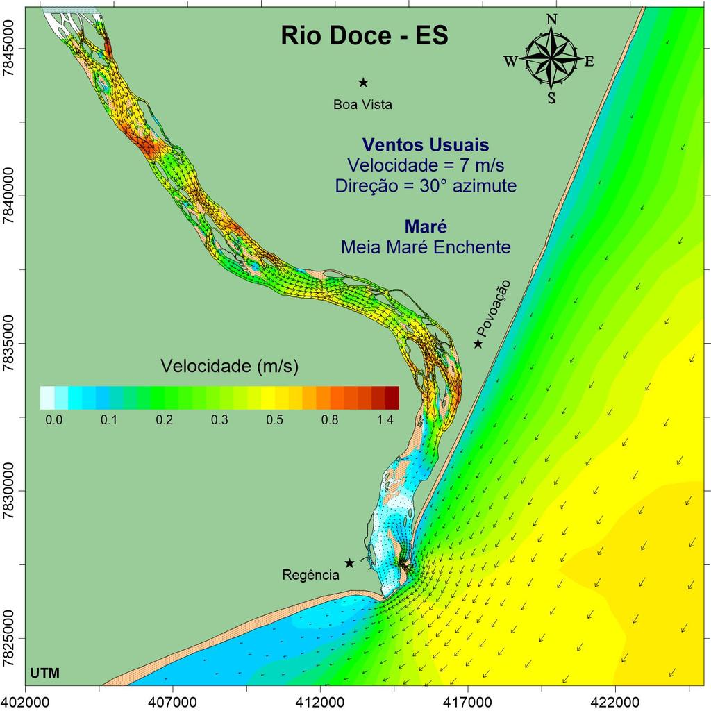
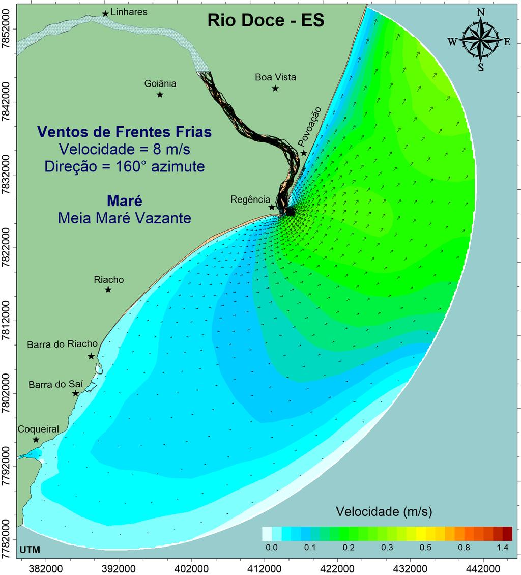
13 - 13 Hydrodynamic Modeling

14 SST (mg/l) Vazão (m 3 /s) LRF To assess these values consider: Transparent coastal waters: SST <10 mg/l. Waters in estuaries and bays: SST< 100 mg/l. Rivers with muddy waters: SST > 500 mg/l. Madeira river in the dry season: SST ~ 500 mg/l Madeira river in the flood season: SST > 3000 mg/l. Mouth of the Amazon river in the flood season SST ~ 2000 mg/l. Results showing passage of peak load of sediments arriving at the mouth in November /11/ /12/ /01/ /02/ /03/ Vazão - Estação Colatina Tempo Sólidos Suspensos Totais - Linhares 0 20/11/ /12/ /01/ /02/ /03/2016 Tempo
15 SST (mg/l) Vazão (m 3 /s) Results showing flood wave passage in the mouth: January 2016 To assess these values consider: Transparent coastal waters: SST <10 mg/l. Waters in estuaries and bays: SST< 100 mg/l. Rivers with muddy waters: SST > 500 mg/l. Madeira river in the dry season: SST ~ 500 mg/l Madeira river in the flood season: SST > 3000 mg/l. Mouth of the Amazon river in the flood season SST ~ 2000 mg/l. Vazão - Estação Colatina /11/ /12/ /01/ /02/ /03/2016 Tempo Sólidos Suspensos Totais - Linhares /11/ /12/ /01/ /02/ /03/2016 Tempo

16 Persistence of SST above 20, 50 and 100 mg/l between 20/11/2015 and 20/03/
17 Velocidade (m/s) Current Velocity (m/s) Maximum Northward Drift (km) Maximum sediment plume drift northward of the Rio Doce mouth Total Suspended Sediments (SST) and Maximum Northward Drift from the mouth Current Componente velocity component longitudinal parallel da corrente to the coastline de deriva induced induzida by pelos prevailing ventos winds N S /11/ /01/ /03/ /05/ /07/ /09/2016 Tempo Date (dd/mm/yy) 20 km northward of the mouth SST is ~20% of value in Rio Doce 40 km northward of the mouth SST is < 5% of value in Rio Doce
Controlling Processes That Change Land
 1 Name Date Controlling Processes That Change Land People try to control some of the processes that change land. To do this, people apply technology- the use of science to solve problems in everyday life.
Modelling vulnerability of coastal ecosystems to land-based mining pollution: a case study from Brazil
 Modelling vulnerability of coastal ecosystems to land-based mining pollution: a case study from Brazil By Rafael A. Magris, Natalie C. Ban, Jose Monteiro Mining in Brazil is a significant primary industry
CASE STUDY BINGA, PHILIPPINES
 SEDIMENT MANAGEMENT CASE STUDY BINGA, PHILIPPINES Key project features Name: Binga Country: Philippines Category: modify operating rule (focus or redistribute sediment); adaptive strategies Binga hydropower
Earth Science Chapter 6 Section 2 Review
 Name: Class: Date: Earth Science Chapter 6 Section Review Multiple Choice Identify the choice that best completes the statement or answers the question. 1. Most streams carry the largest part of their
Science EOG Review: Landforms
 Mathematician Science EOG Review: Landforms Vocabulary Definition Term canyon deep, large, V- shaped valley formed by a river over millions of years of erosion; sometimes called gorges (example: Linville
Floods Lecture #21 20
 Floods 20 Lecture #21 What Is a Flood? Def: high discharge event along a river! Due to heavy rain or snow-melt During a flood, a river:! Erodes channel o Deeper & wider! Overflows channel o Deposits sediment
CASE STUDY BINGA, PHILIPPINES
 SEDIMENT MANAGEMENT CASE STUDY BINGA, PHILIPPINES Key project features Name: Binga Country: Philippines Category: modify operating rule (focus or redistribute sediment); adaptive strategies Reservoir volume
Changes in Texas Ecoregions
 Comment On Lesson Changes in Texas Ecoregions The state of Texas can be divided into 10 distinct areas based on unique combinations of vegetation, topography, landforms, wildlife, soil, rock, climate,
Strategies for managing sediment in dams. Iwona Conlan Consultant to IKMP, MRCS
 Strategies for managing sediment in dams Iwona Conlan Consultant to IKMP, MRCS 1 Sediment trapping by dams Active storage capacity Dead storage coarse material (bed load) Fine materials (suspension) Francis
Tips for Success on a Test
 Number of Incorrect: Final Grade: Parent Signature: Top Tips for Success on a Test 1. Read the following statements at least two times. 2. Circle the key words in each question/ or statement. (*Remember
Sediment Transport Modelling of Proposed Maintenance Dredging of the Outer and Inner Berths at the Aughinish Marine Terminal, Shannon Estuary
 Sediment Transport Modelling of Proposed Maintenance Dredging of the Outer and Inner Berths at the Aughinish Marine Terminal, Shannon Estuary Prepared for Malachy Walsh & Partners On behalf of Aughinish
Technical Review of Pak Beng Hydropower Project (1) Hydrology & Hydraulics and (2) Sediment Transport & River Morphology
 Hydrology & Hydraulics and (2) Sediment Transport & River Morphology") Technical Review of Pak Beng Hydropower Project (1) Hydrology & Hydraulics and (2) Sediment Transport & River Morphology The 2 nd Regional Stakeholder Forum The Pak Beng Hydropower Project 5 th May 2017
Technical Review of Pak Beng Hydropower Project (1) Hydrology & Hydraulics and (2) Sediment Transport & River Morphology The 2 nd Regional Stakeholder Forum The Pak Beng Hydropower Project 5 th May 2017
Tarbela Dam in Pakistan. Case study of reservoir sedimentation
 Tarbela Dam in Pakistan. HR Wallingford, Wallingford, UK Published in the proceedings of River Flow 2012, 5-7 September 2012 Abstract Reservoir sedimentation is a main concern in the Tarbela reservoir
27. Running Water I (p ; )
") 27. Running Water I (p. 424-436; 440-444) Hydrosphere How much of the Earth s surface is covered by water? Earth's water is collectively called the and is stored in a number of so-called as follows: 1.
27. Running Water I (p. 424-436; 440-444) Hydrosphere How much of the Earth s surface is covered by water? Earth's water is collectively called the and is stored in a number of so-called as follows: 1.
Sediment Transport and Strata Formation in the Adriatic Sea
 Sediment Transport and Strata Formation in the Adriatic Sea Wayne R. Geyer James D. Irish Peter A. Traykovski Woods Hole Oceanographic Institution Woods Hole, MA 02543 Tel. (508) 289-2868, Fax: (508) 457-2194,
3D Modelling of Combined Dredge and Disposal Plumes Dispersion. Mathews Morais
 3D Modelling of Combined Dredge and Disposal Plumes Dispersion Mathews Morais About Vale Brazilian global mining company; Leader in the production of iron ore and the second largest producer of nickel;
SHORELINE AND BEACH PROCESSES: PART 2. Implications for Coastal Engineering
 SHORELINE AND BEACH PROCESSES: PART 2 Implications for Coastal Engineering Objectives of the lecture: Part 2 Show examples of coastal engineering Discuss the practical difficulties of ocean engineering
Sedimentation in the Nile River
 Advanced Training Workshop on Reservoir Sedimentation Sedimentation in the Nile River Prof. Dr. Abdalla Abdelsalam Ahmed 10-16 Oct. 2007, IRTCES, Beijing, China CWR,Sudan 1 Water is essential for mankind
National Hydrology committee of Afghanistan (NHCA) Sedimentation in Reservoire
 Sedimentation in Reservoire") National Hydrology committee of Afghanistan (NHCA) Sedimentation in Reservoire OCt.2007 Prof. Mohammad Qasem Seddeqy KPU بسم االله الرحمن الرحيم وجعلنامن الماءکل شي ء حی 30 واز ا ب هر چيزی رازنده گردانيدیم
National Hydrology committee of Afghanistan (NHCA) Sedimentation in Reservoire OCt.2007 Prof. Mohammad Qasem Seddeqy KPU بسم االله الرحمن الرحيم وجعلنامن الماءکل شي ء حی 30 واز ا ب هر چيزی رازنده گردانيدیم
State Water Survey Division SURFACE WATER SECTION
 State Water Survey Division SURFACE WATER SECTION AT THE UNIVERSITY OF ILLINOIS Illinois Department of Energy and Natural Resources SWS Miscellaneous Publication 88 SEDIMENTATION OF POOL 19 ON THE MISSISSIPPI
B-1. Attachment B-1. Evaluation of AdH Model Simplifications in Conowingo Reservoir Sediment Transport Modeling
 Attachment B-1 Evaluation of AdH Model Simplifications in Conowingo Reservoir Sediment Transport Modeling 1 October 2012 Lower Susquehanna River Watershed Assessment Evaluation of AdH Model Simplifications
Chapter 11. Rivers: Shaping our landscape
 Chapter 11 Rivers: Shaping our landscape Learning outcomes In this presentation you will learn: Common terms associated with rivers About the three stages of a river About the processes of river erosion
3/3/2013. The hydro cycle water returns from the sea. All "toilet to tap." Introduction to Environmental Geology, 5e
 Introduction to Environmental Geology, 5e Running Water: summary in haiku form Edward A. Keller Chapter 9 Rivers and Flooding Lecture Presentation prepared by X. Mara Chen, Salisbury University The hydro
Estimated Sediment Volume: Bridge Street Dam Impoundment, Royal River, Yarmouth, Maine
 University of Southern Maine USM Digital Commons Publications Casco Bay Estuary Partnership (CBEP) 2015 Estimated Sediment Volume: Bridge Street Dam Impoundment, Royal River, Yarmouth, Maine Stantec Follow
Development and application of demonstration MIKE 21C morphological model for a bend in Mekong River
 Development and application of demonstration MIKE 21C morphological model for a bend in Mekong River September 2015 0 Table of Contents 1. Introduction... 2 2. Data collection... 3 2.1 Additional data...
Year 6. Geography. Revision
 Year 6 Geography Revision November 2017 Rivers and World knowledge How the water cycle works and the meaning of the terms evaporation, condensation, precipitation, transpiration, surface run-off, groundwater
How to predict the sedimentological impacts of reservoir operations?
 ICSE 212 How to predict the sedimentological impacts of reservoir operations? E. Valette EDF CIH eric.valette@edf.fr M. Jodeau EDF R&D LNHE magali.jodeau@edf.fr Presentation of the numerical code Courlis
Appendix O. Sediment Transport Modelling Technical Memorandum
 Appendix O Sediment Transport Modelling Technical Memorandum w w w. b a i r d. c o m Baird o c e a n s engineering l a k e s design r i v e r s science w a t e r s h e d s construction Final Report Don
Research Topic Updated on Oct. 9, 2014
 Research Topic Updated on Oct. 9, 204 Mixed Cohesive/Non-cohesive Sediments Sedimentation in Estuary: Flocculation Deposition Erosion Transport Consolidation *: It has been recognized that when the fraction
Science of Natural Disasters: RIVERS& FLOODS! 27 April 2016
 Science of Natural Disasters: RIVERS& FLOODS! 27 April 2016 Rebecca Clotts Department of Geology, University of St Thomas Flood in St Paul, 2014, Star Tribune 1 2 What is a watershed? 3 4 5 6 7 What is
Island Design. UMRS EMP Regional Workshop. Presentation for the
 Island Design Presentation for the UMRS EMP Regional Workshop by Jon Hendrickson Hydraulic Engineer Regional Technical Specialist, Water Quality and Habitat Restoration August 17 19, 2005 Project Delivery
Influence of the Major Drainages to the Mississippi River and Implications for System Level Management
 Influence of the Major Drainages to the Mississippi River and Implications for System Level Management Brian M. Vosburg Geologist Louisiana Coastal Protection and Restoration Authority brian.vosburg@la.gov
SEDIMENT TRANSPORT IN RIVER MOUTH ESTUARY
 SEDIMENT TRANSPORT IN RIVER MOUTH ESTUARY Katsuhide YOKOYAMA, Dr.Eng. dredge Assistant Professor Department of Civil Engineering Tokyo Metropolitan University 1-1 Minami-Osawa Osawa, Hachioji,, Tokyo,
Project (Project No. US-CA-62-2) Maintenance Inspection and Reports (Subtask 14.1) Inspection Report No.2
 Maintenance Inspection and Reports (Subtask 14.1) Inspection Report No.2") MEMORANDUM TO: FROM: Jim Well, Ducks Unlimited Mike Harvey, PhD, PG SUBJECT: M&T/ Llano Seco Fish Screen Project (Project No. US-CA-62-2) Maintenance Inspection and Reports (Subtask 14.1) Inspection Report
MEMORANDUM TO: FROM: Jim Well, Ducks Unlimited Mike Harvey, PhD, PG SUBJECT: M&T/ Llano Seco Fish Screen Project (Project No. US-CA-62-2) Maintenance Inspection and Reports (Subtask 14.1) Inspection Report
What is weathering and how does it change Earth s surface? Answer the question using
 7 th Grade Lesson What is weathering and how does it change Earth s surface? Answer the question using the sentence frame. You have 4 minutes. Weathering is. This changes the Earth s surface because. 1
ES 105 Surface Processes I. Hydrologic cycle A. Distribution % in oceans 2. >3% surface water a. +99% surface water in glaciers b.
 ES 105 Surface Processes I. Hydrologic cycle A. Distribution 1. +97% in oceans 2. >3% surface water a. +99% surface water in glaciers b. >1/3% liquid, fresh water in streams and lakes~1/10,000 of water
Catastrophic Events Impact on Ecosystems
 Catastrophic Events Impact on Ecosystems Hurricanes Hurricanes An intense, rotating oceanic weather system with sustained winds of at least 74 mph and a welldefined eye Conditions for formation: Warm water
Physical landscapes River landscapes in the UK
 Physical landscapes River landscapes in the UK The shape of river valleys change s as rivers flow downstream - PROCESSES Erosion Abrasion or corrasion Attrition Hydraulic Action Solution or corrosion Deposition
Appendix A Flood Damages in 2013
 Appendix A Flood Damages in 2013 RPT2-2014-07-09-App_A_Highwood_River_Flood_Damage_In_2013.Docx Table of Contents page Sign-Off 1. Flood Damage in 2013... 1 1.1 Background... 1 1.2 Town of High River...
The Use of Water an Impact to the Eco-system
 Continuous Sediment Transfer ConSedTrans - Method A way to reduce the risk of sedimentation and siltation, flooding, soil and coast erosion, and saltation of groundwater. ACWUA s 5th Best Practices Conference
Stream Geomorphology. Leslie A. Morrissey UVM July 25, 2012
 Stream Geomorphology Leslie A. Morrissey UVM July 25, 2012 What Functions do Healthy Streams Provide? Flood mitigation Water supply Water quality Sediment storage and transport Habitat Recreation Transportation
CR AAO Bridge. Dead River Flood & Natural Channel Design. Mitch Koetje Water Resources Division UP District
 CR AAO Bridge Dead River Flood & Natural Channel Design Mitch Koetje Water Resources Division UP District Old County Road AAO Bridge Map courtesy of Marquette County Silver Lake Basin McClure Basin
Environmental Geology Chapter 9 Rivers and Flooding
 Environmental Geology Chapter 9 Rivers and Flooding Flooding in Pakistan 2010-1600 killed/20000 affected The hydrologic cycle is powered by the Sun The cycle includes evaporation, precipitation, infiltration,
Term Knowledge Using and applying Grade Criteria Autumn 1 Assessment window October Natural hazards pose major risks to people and property.
 Assessment Schedule Year 9 2015/6 Term Knowledge Using and applying Grade Criteria Autumn 1 Assessment window October 2015 3.1.1.2 Tectonic Natural hazards pose major risks to people and property. Definition
Learning Objectives: I can identify and interpret river flows and directions.
 Learning Objectives: I can identify and interpret river flows and directions. Bellringer Review: Check for Understanding Questions: 1 2 What Are The Key Parts Of A River s Anatomy? In your data notebooks
ADDRESSING GEOMORPHIC AND HYDRAULIC CONTROLS IN OFF-CHANNEL HABITAT DESIGN
 ADDRESSING GEOMORPHIC AND HYDRAULIC CONTROLS IN OFF-CHANNEL HABITAT DESIGN Conor Shea - Hydrologist U.S. Fish and Wildlife Service Conservation Partnerships Program Arcata, CA Learning Objectives Examine
Sessom Creek Sand Bar Removal HCP Task 5.4.6
 Sessom Creek Sand Bar Removal HCP Task 5.4.6 Prepared by: Dr. Thomas Hardy Texas State University Dr. Nolan Raphelt Texas Water Development Board January 6, 2013 DRAFT 1 Introduction The confluence of
Vietnam Coastal Erosion - Cause and Challenges -
 Administration of Sea and Islands Center for Oceanography University of Transport and Communications, Hanoi Vietnam Vietnam Coastal Erosion - Cause and Challenges - Presenters: Pham Hoang KIEN Le Van CONG
June 2018 Sediments and Dredging at GBR Ports
 June 2018 Sediments and Dredging at GBR Ports Reef 2050 Long Term Sustainability Plan The Great Barrier Reef is over 2000 km long and covers an area of approximately 350,000 square kilometres. It is a
Els van Lavieren (Conservation International Suriname) Prof. Sieuwnath Naipal (Anton de Kom University, Suriname) 1
 Prof. Sieuwnath Naipal (Anton de Kom University, Suriname) 1") Building with Nature at Weg naar Zee, Paramaribo, Suriname A nature based solution for coastal resilience & mangrove restoration Ecological Mangrove Restoration Concept Els van Lavieren (Conservation International
Building with Nature at Weg naar Zee, Paramaribo, Suriname A nature based solution for coastal resilience & mangrove restoration Ecological Mangrove Restoration Concept Els van Lavieren (Conservation International
Technical Memorandum No Sediment Model
 Pajaro River Watershed Study in association with Technical Memorandum No. 1.2.9 Sediment Model Task: Development of Sediment Model To: PRWFPA Staff Working Group Prepared by: Gregory Morris and Elsie Parrilla
Appendix G.19 Hatch Report Pacific NorthWest LNG Lelu Island LNG Maintenance Dredging at the Materials Offloading Facility
 Appendix G.19 Hatch Report Pacific NorthWest LNG Lelu Island LNG Maintenance Dredging at the Materials Offloading Facility Project Memo H345670 To: Capt. David Kyle From: O. Sayao/L. Absalonsen December
IS THERE ENOUGH SEDIMENT? Presentation at the State of the Estuary Conference San Francisco, CA, October 9-10, By Philip B.
 IS THERE ENOUGH SEDIMENT? Presentation at the State of the Estuary Conference San Francisco, CA, October 9-10, 2001 By Philip B. Williams 1. INTRO I AM TEMPTED TO MAKE THIS THE SHORTEST TALK OF THE CONFERENCE:
New GCSE Geography AQA
 Learning Checklist Half Term 1 26 th September 3 rd October 10 th October 17 th October 1.1.1 Tectonic Hazards Plate tectonics theory. Global distribution of earthquakes and volcanic eruptions and their
SCOPE OF PRESENTATION STREAM DYNAMICS, CHANNEL RESTORATION PLANS, & SEDIMENT TRANSPORT ANALYSES IN RELATION TO RESTORATION PLANS
 DESIGN METHODS B: SEDIMENT TRANSPORT PROCESSES FOR STREAM RESTORATION DESIGN PETER KLINGEMAN OREGON STATE UNIVERSITY CIVIL ENGINEERING DEPT., CORVALLIS 2 ND ANNUAL NORTHWEST STREAM RESTORATION DESIGN SYMPOSIUM
[1] Performance of the sediment trap depends on the type of outlet structure and the settling pond surface area.
![[1] Performance of the sediment trap depends on the type of outlet structure and the settling pond surface area.](/thumbs/76/74245181.jpg "[1] Performance of the sediment trap depends on the type of outlet structure and the settling pond surface area.") Sediment Trench SEDIMENT CONTROL TECHNIQUE Type 1 System Sheet Flow Sandy Soils Type 2 System [1] Concentrated Flow Clayey Soils Type 3 System [1] Supplementary Trap Dispersive Soils [1] Performance of
Sediment Trench SEDIMENT CONTROL TECHNIQUE Type 1 System Sheet Flow Sandy Soils Type 2 System [1] Concentrated Flow Clayey Soils Type 3 System [1] Supplementary Trap Dispersive Soils [1] Performance of
Chapter 2. Denudation: Rivers and Ice
 Chapter 2. Denudation: Rivers and Ice DENUDATION: process that lowers level of land - caused by rivers, glaciers, waves & wind - involves processes of WEATHERING & EROSION Weathering Def: breakdown of
GEOL 1121 Earth Processes and Environments
 GEOL 1121 Earth Processes and Environments Wondwosen Seyoum Department of Geology University of Georgia e-mail: seyoum@uga.edu G/G Bldg., Rm. No. 122 Seyoum, 2015 Chapter 6 Streams and Flooding Seyoum,
SPECIFIC DEGRADATION AND RESERVOIR SEDIMENTATION. By Renee Vandermause & Chun-Yao Yang
 SPECIFIC DEGRADATION AND RESERVOIR SEDIMENTATION By Renee Vandermause & Chun-Yao Yang Outline Sediment Degradation - Erosion vs Sediment Yield - Sediment Yield - Methods for estimation - Defining Sediment
From micro to macro scale the impact on the sediment discharge after construction of the Three Gorges Dam on Yangtze River (Changjiang)
") From micro to macro scale the impact on the sediment discharge after construction of the Three Gorges Dam on Yangtze River (Changjiang) Aleksandra Dewiszek 9th International SedNet conference Solving societal
From micro to macro scale the impact on the sediment discharge after construction of the Three Gorges Dam on Yangtze River (Changjiang) Aleksandra Dewiszek 9th International SedNet conference Solving societal
Earth processes are dynamic actions that occur both on
 29 Weathering, Erosion, and Deposition R EA D I N G Earth processes are dynamic actions that occur both on the earth s surface and inside the earth. Any process that breaks down earth material, such as
The Danube River. Hydrological Connectivity and Human Influence. By: Pat O Connell, Pat Wilkins, Tiana Royer, and Kevin Gaitsch
 The Danube River Hydrological Connectivity and Human Influence By: Pat O Connell, Pat Wilkins, Tiana Royer, and Kevin Gaitsch Danube River Characteristics Length: 2860 km Drainage Area: 816,000 km 2 Peak
The Coast: Beaches and Shoreline Processes
 1 2 3 4 5 6 7 8 9 The Coast: es and Shoreline Processes Trujillo & Thurman, Chapter 10 Oceanography 101 Chapter Objectives Recognize the various landforms characteristic of beaches and coastal regions.
Essential Questions. What is erosion? What is mass wasting?
 Erosion Essential Questions What is erosion? What is mass wasting? What is Erosion? Erosion The transportation of sediment from one area to another Caused mainly by running water but also caused by glaciers,
CASE STUDY NATHPA JHAKRI, INDIA
 SEDIMENT MANAGEMENT CASE STUDY NATHPA JHAKRI, INDIA Key project features Name: Nathpa Jhakri Country: India Category: reduce sediment production (watershed management); upstream sediment trapping; bypass
The Coast: Beaches and Shoreline Processes Trujillo & Thurman, Chapter 10
 The Coast: es and Shoreline Processes Trujillo & Thurman, Chapter 10 Oceanography 101 Chapter Objectives Recognize the various landforms characteristic of beaches and coastal regions. Identify seasonal
Streams. Stream Water Flow
 CHAPTER 14 OUTLINE Streams: Transport to the Oceans Does not contain complete lecture notes. To be used to help organize lecture notes and home/test studies. Streams Streams are the major geological agents
Upgrading Feasibility Study on the Upper Seti Storage Hydroelectric Project in Nepal
 6.5 Evaporation Evaporation is measured at No. 815 meteorological station, EL. 5 m, in the Seti River basin. The average monthly evaporation from 1977 to 1997 is as shown in Table 6.5-1. Table 6.5-1 Average
EAGLES NEST AND PIASA ISLANDS
 EAGLES NEST AND PIASA ISLANDS HABITAT REHABILITATION AND ENHANCEMENT PROJECT MADISON AND JERSEY COUNTIES, ILLINOIS ENVIRONMENTAL MANAGEMENT PROGRAM ST. LOUIS DISTRICT FACT SHEET I. LOCATION The proposed
Sediment management plans in French mountainous catchments with illustrations from emblematic projects Dr. Benoit Terrier
 Sediment management plans in French mountainous catchments with illustrations from emblematic projects Dr. Benoit Terrier Agence de l Eau Rhône Méditerranée et Corse, FRANCE Presentation layout 1. The
Fresh Water: Streams, Lakes Groundwater & Wetlands
 Fresh Water:, Lakes Groundwater & Wetlands Oct 27 Glaciers and Ice Ages Chp 13 Nov 3 Deserts and Wind and EXAM #3 Slope hydrologic cycle P = precip I = precip intercepted by veg ET = evapotranspiration
CASE STUDY NATHPA JHAKRI, INDIA
 SEDIMENT MANAGEMENT CASE STUDY NATHPA JHAKRI, INDIA Key project features Name: Nathpa Jhakri Country: India Category: reforestation/revegetation; upstream sediment trapping; bypass channel/tunnel; reservoir
Predicting the implications of tidal energy barrages: the use of analogues in exploring environmental issues
 Predicting the implications of tidal energy barrages: the use of analogues in exploring environmental issues Roger Morris Bright Angel Coastal Consultants Structure of this presentation Introduction to
STUDY AREA AND METHODOLOGY
 . CHAPTER 2 STUDY AREA AND METHODOLOGY 26 CHAPTER 2 STUDY AREA AND METHODOLOGY Kundalika is a major river in konkan region of Maharashtra. River originates in Western Ghats at an altitude of 820 m ASL
A MULTI-CRITERIA APPROACH SUPPORTING THE INVESTIGATION OF A FLOODPLAIN POTENTIALLY CONTAMINATED BY PESTICIDES
 A MULTI-CRITERIA APPROACH SUPPORTING THE INVESTIGATION OF A FLOODPLAIN POTENTIALLY CONTAMINATED BY PESTICIDES L ZILIANI, B GROPPELLI, S CECCON, F COLOMBO (RAMBOLL ENVIRON) D BOCCHIOLA, M C RULLI, G RAVAZZANI,
Current Status of Vietnam Coastal Erosion and Major Measures for Mitigation
 Vietnam Administration of Sea and Islands Center for Oceanography University of Transport and Communications Current Status of Vietnam Coastal Erosion and Major Measures for Mitigation Case Study: Thanh
STUDY GUIDE FOR CONTENT MASTERY. Surface Water Movement
 Surface Water SECTION 9.1 Surface Water Movement In your textbook, read about surface water and the way in which it moves sediment. Complete each statement. 1. An excessive amount of water flowing downslope
Figure 1. Which part of the river is labelled in Figure 1? a) Mouth b) Source c) Lower course d) channel
 Mouth b) Source c) Lower course d) channel") Rivers 1. Study Figure 1 showing the long profile of a river Figure 1 A Which part of the river is labelled in Figure 1? a) Mouth b) Source c) Lower course d) channel (1 mark) 2. Complete the sentences
Rivers 1. Study Figure 1 showing the long profile of a river Figure 1 A Which part of the river is labelled in Figure 1? a) Mouth b) Source c) Lower course d) channel (1 mark) 2. Complete the sentences
ΛTKINS. Applications of Regional Sediment Management Concepts in Texas Estuarine Restoration Projects. Riparian Workshop Fort Worth, October 17, 2012
 Juan C Moya, PhD., PG Coastal Planning and Restoration Applications of Regional Sediment Management Concepts in Texas Estuarine Restoration Projects Riparian Workshop Fort Worth, October 17, 2012 West
STREAM SYSTEMS and FLOODS
 STREAM SYSTEMS and FLOODS The Hydrologic Cycle Precipitation Evaporation Infiltration Runoff Transpiration Earth s Water and the Hydrologic Cycle The Hydrologic Cycle The Hydrologic Cycle Oceans not filling
Precipitation Evaporation Infiltration Earth s Water and the Hydrologic Cycle. Runoff Transpiration
 STREAM SYSTEMS and FLOODS The Hydrologic Cycle Precipitation Evaporation Infiltration Earth s Water and the Hydrologic Cycle Runoff Transpiration The Hydrologic Cycle The Hydrologic Cycle Oceans not filling
The spatial distribution of suspended sediment analysis along Krueng Cut River, Banda Aceh
 IOP Conference Series: Earth and Environmental Science PAPER OPEN ACCESS The spatial distribution of suspended sediment analysis along Krueng Cut River, Banda Aceh To cite this article: M Irham et al 08
The Imperative of Sediment Management Concepts in River Basin Management Plans
 The Imperative of Sediment Management Concepts in River Basin Management Plans Stefan Vollmer, Thomas Hoffmann, Gudrun Hillebrand, Ina Quick, Axel Winterscheid Department M3 Groundwater, Geology, River
How Do Human Impacts and Geomorphological Responses Vary with Spatial Scale in the Streams and Rivers of the Illinois Basin?
 How Do Human Impacts and Geomorphological Responses Vary with Spatial Scale in the Streams and Rivers of the Illinois Basin? Bruce Rhoads Department of Geography University of Illinois at Urbana-Champaign
APPROACH TO THE SPANISH WATER ORGANISATION IMPROVING FLOOD HAZARD MAPPING, LAWS AND AUTHORITIES COORDINATION
 "Workshop On Land Use Planning And Water Management, With Focus On Flood Risk Management Oslo, Norway. Wednesday 31 January and Thursday 1 February 2007 APPROACH TO THE SPANISH WATER ORGANISATION IMPROVING
UGRC 144 Science and Technology in Our Lives/Geohazards
 UGRC 144 Science and Technology in Our Lives/Geohazards Flood and Flood Hazards Dr. Patrick Asamoah Sakyi Department of Earth Science, UG, Legon College of Education School of Continuing and Distance Education
Huong River. Serial No. : Viet Nam-8 Location: Thua Thien Hue Province, Viet Nam N 16 00' '
 Viet Nam 8 Huong River Map of River Table of Basic Data Name: Huong River Serial No. : Viet Nam-8 Location: Thua Thien Hue Province, Viet Nam N 16 00' - 14 40' E 107 07' - 107 50' 2 Area: 2,830 km Length
Subcommittee on Sedimentation Draft Sediment Analysis Guidelines for Dam Removal
 Subcommittee on Sedimentation Draft Sediment Analysis Guidelines for Dam Removal August 4, 2011 Jennifer Bountry, M.S., P.E. Tim Randle, M.S., P.E., D.WRE. Blair Greimann, Ph.D., P.E. Sedimentation and
Sediment and nutrient transport and storage along the urban stream corridor
 Sediment and nutrient transport and storage along the urban stream corridor Greg Noe, Cliff Hupp, Ed Schenk, Jackie Batson, Nancy Rybicki, Allen Gellis What is the role of floodplains everywhere? Noe 2013,
Session: For more information:
 Session: For more information: www.hydropower.org/congress San Juan, Puerto Rico www.glmengineers.com 2015 World Hydropower Congress Sustainable Sediment Management and Hydropower Reservoirs 21 May 2015
Special Public Notice
 Special Public Notice Applicability: General Public Date: June 3, 2014 The purpose of this public notice is to inform you of existing guidance and policy contained in Regulatory Guidance Letter 05-04 concerning
2. PRESENT CONDITION OF THE RESERVOIR 2.1 View of Wonogiri Reservoir (1/3)
") 2.1 View of Wonogiri Reservoir (1/3) Wonogiri dam abutment on the left side of dam Spillway forebay on thet left side of dam Bank erosion around Wonogiri reservoir. Wonogiri Dam view from chersonese. An
2.1 View of Wonogiri Reservoir (1/3) Wonogiri dam abutment on the left side of dam Spillway forebay on thet left side of dam Bank erosion around Wonogiri reservoir. Wonogiri Dam view from chersonese. An
Long-Term Effects Of River Bed Variations Downstream Of The Shihmen Reservoir Due To Climate Change
 City University of New York (CUNY) CUNY Academic Works International Conference on Hydroinformatics 8-1-2014 Long-Term Effects Of River Bed Variations Downstream Of The Shihmen Reservoir Due To Climate
Stream Restoration and Environmental River Mechanics. Objectives. Pierre Y. Julien. 1. Peligre Dam in Haiti (deforestation)
") Stream Restoration and Environmental River Mechanics Pierre Y. Julien Malaysia 2004 Objectives Brief overview of environmental river mechanics and stream restoration: 1. Typical problems in environmental
Stream Restoration and Environmental River Mechanics Pierre Y. Julien Malaysia 2004 Objectives Brief overview of environmental river mechanics and stream restoration: 1. Typical problems in environmental
Weathering and Erosion
 Have you ever looked at the land around you and wondered how it was shaped? The geologic features that help define the world are still being shaped by the natural processes of weathering, erosion, and
Soil erosion susceptibility and coastal evolution: examples in southern New Caledonia
 Pacific Island Countries GIS /RS User Conference Soil erosion susceptibility and coastal evolution: examples in southern New Caledonia Pascal DUMAS et Olivier COHEN University of New-Caledonia (EA 4242/
Running Water Earth - Chapter 16 Stan Hatfield Southwestern Illinois College
 Running Water Earth - Chapter 16 Stan Hatfield Southwestern Illinois College Hydrologic Cycle The hydrologic cycle is a summary of the circulation of Earth s water supply. Processes involved in the hydrologic
Behavior of radioactive cesium accumulation in water bodies in contaminated area by FDNPP accident
 Behavior of radioactive cesium accumulation in water bodies in contaminated area by FDNPP accident Seiji HAYASHI Center for Regional Environmental Research National Institute for Environmental Studies
Beach Recovery Processes in Urban Beach Systems : A Study in Hong Kong after an Extreme Storm Event
 Beach Recovery Processes in Urban Beach Systems : A Study in Hong Kong after an Extreme Storm Event LIFE+ FLANDRE international workshop "Management of coastal dunes and sandy beaches" Session 1. Climate
Remaining Capacity in Great Lakes Reservoirs
 US Army Corps of Engineers Detroit District Remaining Capacity in Great Lakes Reservoirs Storage Capacity Behind Great Lakes Dams Field Data and Modeling Motivation for project Project overview Data and