Els van Lavieren (Conservation International Suriname) Prof. Sieuwnath Naipal (Anton de Kom University, Suriname) 1
|
|
|
- Roderick Gardner
- 5 years ago
- Views:
Transcription
 Prof.")
1 Building with Nature at Weg naar Zee, Paramaribo, Suriname A nature based solution for coastal resilience & mangrove restoration Ecological Mangrove Restoration Concept Els van Lavieren (Conservation International Suriname) Prof. Sieuwnath Naipal (Anton de Kom University, Suriname) 1

2 Suriname & Guiana shield Suriname Located on the Guianas Coast on the north coast of South America Coastal structure is dominated by mud outflow from the Amazon River, with extensive areas of mangrove forest across wide, lowlying floodplains muddy coast Paramaribo is the capital city of Suriname & the only substantial urban section along Suriname s 386 km long coast Guyana SURINAME French Guiana Brazil 2

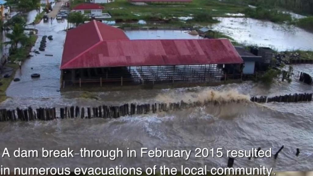
3 Location Weg naar Zee (WnZ) Weg naar Zee is the northern part of Paramaribo Agricultural heart of the Paramaribo region Much of the original mangrove forest is removed (anthropogenic disturbance) It has accelerated local erosion Its low-lying land is subject to coastal and runoff flooding Under development pressure The primary livelihood activities in this coastal area are agriculture, fisheries, and apiculture At risk of salinization 3


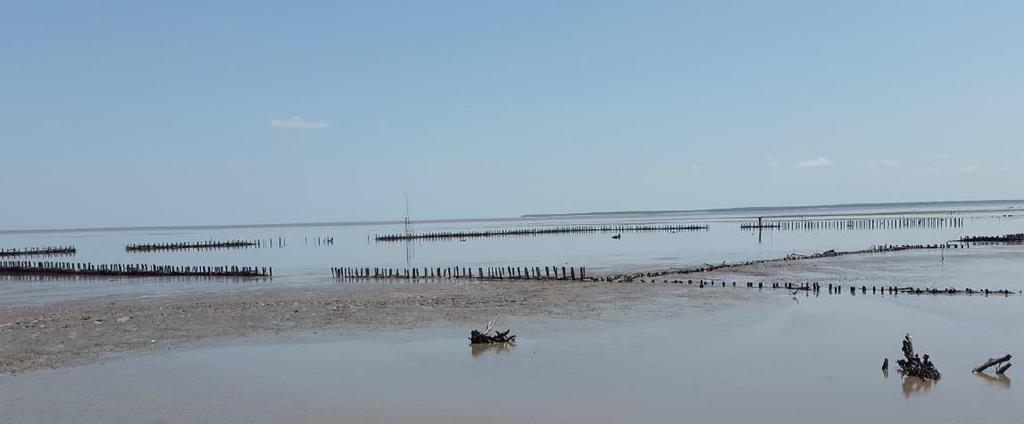
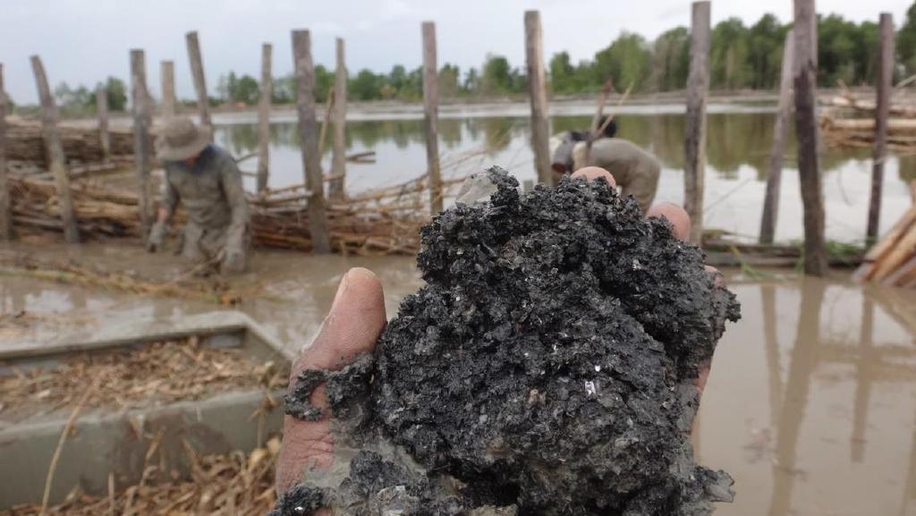
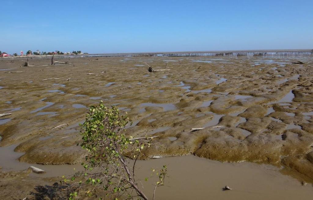
4 Erosion at Weg naar Zee 4
5 5
 30-50 km long mudbanks migrating along the coast at")
6 Sediment supply (P. Augustinus) km long mudbanks migrating along the coast at a rate of 1-3 km per year (every 30 years) 6
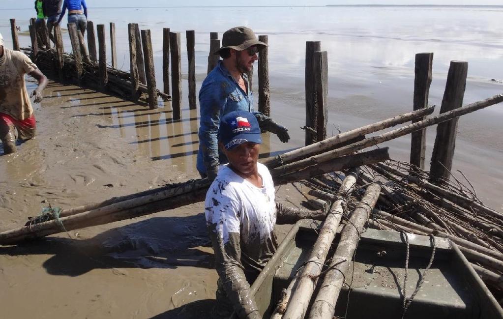
7 Hard solutions vs soft / green/ nature based solutions 7


8 Hard/ grey solutions vs muddy coasts Source: Wetlands International Disturbed balance between incoming and outgoing sediment Bigger waves and more soil erosion in front of the hard structure Large/ high waves are needed to deposit sediment breakwaters prevent high waves Expensive (construction and maintenance) Incapable of adapting to climate change They fail to provide the vital economic, environmental and social services that healthy mangrove belts provide 8
9 9
 Marshes / kwelders in Netherlands Building with Nature Indonesia Millions")

10 Salt marshes in the Netherlands an inspiration for other countries (with muddy coasts) Marshes / kwelders in Netherlands Building with Nature Indonesia Millions of people living along coast of Demak (Java) A whole village is supported by this project with income from work Indonesian government invested millions in this project 10
 economy and society")
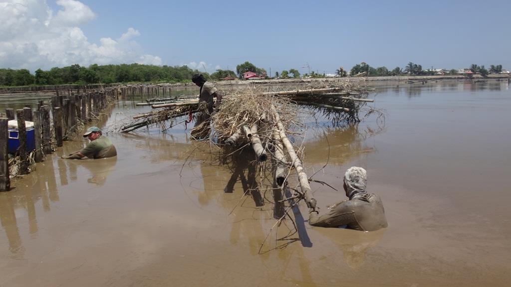
11 Building with Nature concept Developing hydraulic infrastructure: In harmony with the behaviour of the natural system By letting nature do part of the work In close collaboration with stakeholders and local communities With added value for nature, (local) economy and society 11

12 The main objective of this pilot project was to develop adaptation measures against sea level rise, and hence addressing climate change in a sustainable way. The adaptation measure includes e.g. establishing of a sedimentation trapping unit aiming to demonstrate the mitigation of the coastal erosion through accumulation of mud/sediment and restoring conditions for mangrove rehabilitation. Pilot STU: approximate dimensions of (L x W) 150m x 200m Effective starting date was July 11, 2015 The Pilot Sediment Trapping Unit (STU) 12


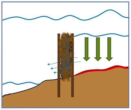
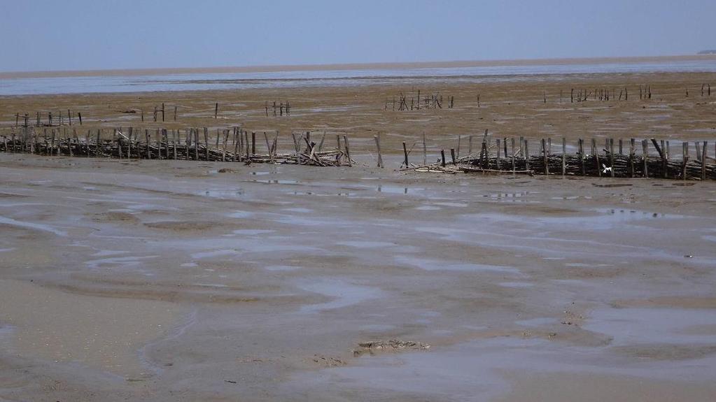
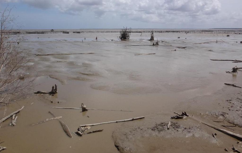
13 Function of the Sediment Trapping Units 13

14 Wind & wave direction 14


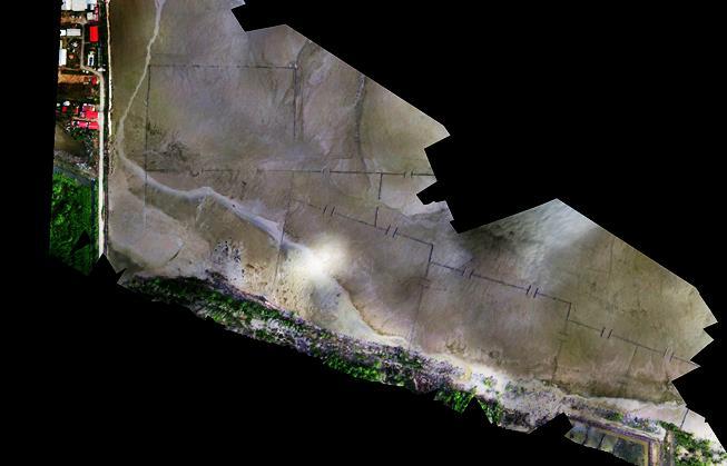
15 Phase 1 (pilot STU) and 2 15
16 Construction of Phase
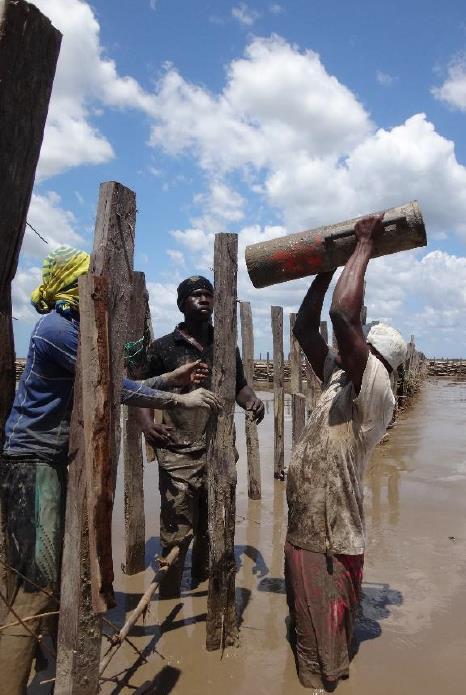
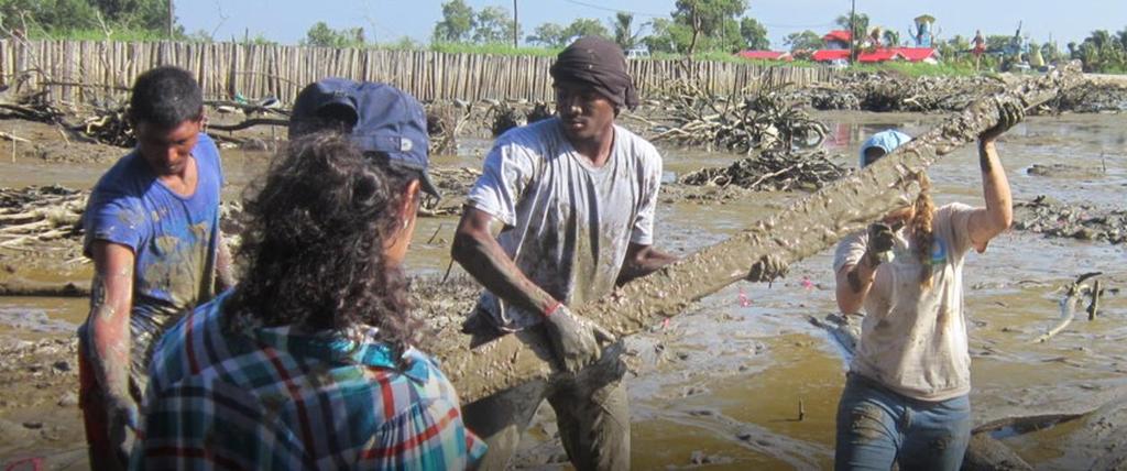
17 Constructing the pilot STU 17
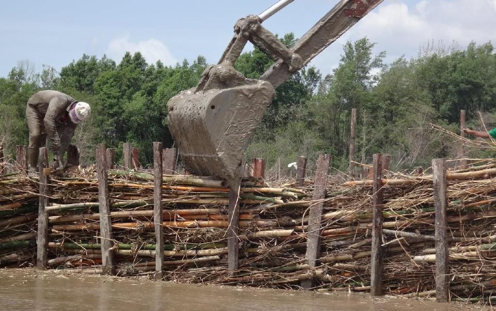
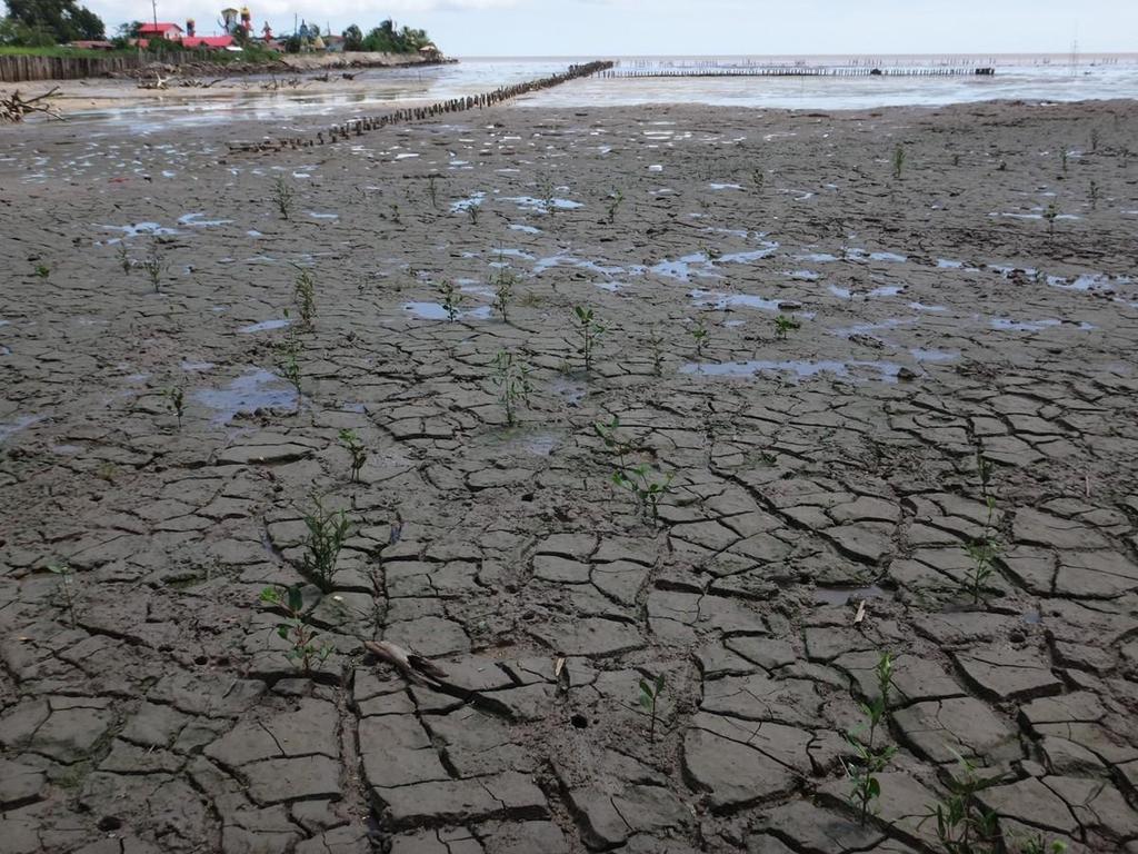
18 Construction of Phase 2 18
19 19
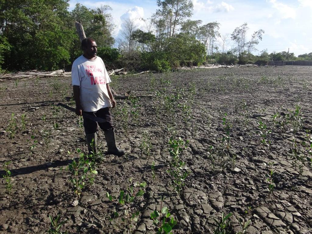
20 Monitoring Placement of 9 staff gauges to monitor seabed elevation 20
21 21

22 Challenges in phase 2 22
23 23
24 24

25 Results 25
26 26
27 27
28 28

29 Clear accumulation of mud despite loss of bamboo on seaward dams 29
30 30
31 Mangrove regeneration (July 2017) 31

32 MANGROVE REGENERATION, July

33 Conclusion & Next steps 33
34 Conclusions & next steps Phase 3 Proof of concept still in progress but the first results look promising We have applied for funding for phase 3 34

35 Acknowledgements The support of the Government of Suriname via the Ministry of Public Works The students of AdeK University, particularly from the Department of Infrastructure Partners Anton de Kom University CI- Suriname SORTS Ecoshape Wetlands International Deltares Biosfera Witteveen & Bos Funders Staatsolie Foundation The Royal Dutch Embassy in Suriname Kosmos Energy 35
Assessing the Permanence of Blue Carbon Sinks
 Assessing the Permanence of Blue Carbon Sinks with Rising Sea Levels Gail L. Chmura and Dante D. Torio Department of Geography, McGill University and Global Environmental and Climate Change Centre Montreal,
Figure 1. Sediment balance of the 1500 km-long muddy coast of South America
 a b c Figure 1. Sediment balance of the 1500 km-long muddy coast of South America between the Amazon and the Orinoco rivers. a, map of the Amazon-Orinoco sediment system. The black box delimits the area
CLIMATE RESILIENT ALTITUDINAL GRADIENTS (CRAGs)
") CLIMATE RESILIENT ALTITUDINAL GRADIENTS (CRAGs) BUILDING CLIMATE CHANGE RESILIENCE IN THE KIVU- RUSIZI WATERSHEDS Great Lake Conference Entebbe 2017 Chris Magero WHAT ARE CRAGs? Climate-Resilient Altitudinal
CLIMATE RESILIENT ALTITUDINAL GRADIENTS (CRAGs) BUILDING CLIMATE CHANGE RESILIENCE IN THE KIVU- RUSIZI WATERSHEDS Great Lake Conference Entebbe 2017 Chris Magero WHAT ARE CRAGs? Climate-Resilient Altitudinal
16540/14 EE/cm 1 DG E 1A
 Council of the European Union Brussels, 5 December 2014 (OR. en) 16540/14 ENV 965 CULT 139 NOTE From: To: Subject: General Secretariat of the Council Delegations Charter of Rome on Natural and Cultural
A Quantitative Assessment of Human Interventions and Climate Change on the West African sediment budget
 Public Disclosure Authorized Public Disclosure Authorized A Quantitative Assessment of Human Interventions and Climate Change on the West African sediment budget Public Disclosure Authorized The West African
CLIMATE CHANGE ADAPTATION BY MEANS OF PUBLIC PRIVATE PARTNERSHIP TO ESTABLISH EARLY WARNING SYSTEM
 CLIMATE CHANGE ADAPTATION BY MEANS OF PUBLIC PRIVATE PARTNERSHIP TO ESTABLISH EARLY WARNING SYSTEM By: Dr Mamadou Lamine BAH, National Director Direction Nationale de la Meteorologie (DNM), Guinea President,
Coastal Vulnerability Assessment in Semarang City, Indonesia Based on Sea Level Rise and Land Subsidence Scenarios
 Coastal Vulnerability Assessment in Semarang City, Indonesia Based on Sea Level Rise and Land Subsidence Scenarios I. M. Radjawane, D. Hartadi and W. R. Lusano Oceanography Research Division Fac. of Earth
Land Use Modelling for Environmental and Ecological Policy Assessment:
 Judith Borsboom Land Use Modelling for Environmental and Ecological Policy Assessment: Sustainable Netherlands Study in collaboration with: Wageningen University & Research centre WL Delft Hydraulics Arcadis
12/05/2016. The First step in Adaptation to future climate change Reduce Vulnerability and Exposure to present Climate Variability (IPCC 2014)
") Integrating CCA, DRR and L+D to Address Emerging Challenges due to Slow Onset Processes Joy Jacqueline Pereira (Project Leader), SEADPRI-Universiti Kebangsaan Malaysia, Nguyen Van Thang (Collaborator),
Integrating CCA, DRR and L+D to Address Emerging Challenges due to Slow Onset Processes Joy Jacqueline Pereira (Project Leader), SEADPRI-Universiti Kebangsaan Malaysia, Nguyen Van Thang (Collaborator),
The UN-GGIM: Europe core data initiative to encourage Geographic information supporting Sustainable Development Goals Dominique Laurent, France
 INSPIRE conference Strasbourg 6 September 2017 The UN-GGIM: Europe core data initiative to encourage Geographic information supporting Sustainable Development Goals Dominique Laurent, France Introduction
New GCSE Geography AQA
 Learning Checklist Half Term 1 26 th September 3 rd October 10 th October 17 th October 1.1.1 Tectonic Hazards Plate tectonics theory. Global distribution of earthquakes and volcanic eruptions and their
Exploring the impacts of future global change on mangrove-fishery-community linkages
 Exploring the impacts of future global change on mangrove-fishery-community linkages Rachel Seary University of Cambridge/ UNEP-WCMC Supervisors: Dr Tom Spencer, Dr Mike Bithell & Dr Chris McOwen Photograph:
INTEGRATING CLIMATE VULNERABILITY & RISK ASSESSMENT INTO URBAN SPATIAL PLANNING PROCESS
 INTEGRATING CLIMATE VULNERABILITY & RISK ASSESSMENT INTO URBAN SPATIAL PLANNING PROCESS (CASE STUDY: BLITAR CITY, EAST JAVA, INDONESIA) SHINTA MICHIKO PUTERI, ST, MT. DR. IR. DENNY ZULKAIDI, MUP. WRITER
Sri Lanka has a coastline of km excluding the shoreline of bays and inlets.
 Defining and Demarcating Coastal zones in Sri Lanka Procedure, Challenges and What needs to be done? Dr. Anil Premaratne Director General Coast Conservation Coast Conservation Department Sri Lanka 1 Sri
P.G.E.F. Augustinus Institute for Marine and Atmospheric Research Utrecht, Utrecht University, The Netherlands
 COASTAL SYSTEMS P.G.E.F. Augustinus Institute for Marine and Atmospheric Research Utrecht, Utrecht University, The Netherlands Keywords: Coastal systems, morphodynamic systems, coastal geomorphology Contents
FIG Working Week May, Bulgaria From the wisdom of the ages to the challanges of modern world
 FIG Working Week 17-21 May, Bulgaria From the wisdom of the ages to the challanges of modern world COASTAL RISK ANALYSIS OF THE BLACK SEA UNDER THE SEA LEVEL RISE N e v i n B e t u l A V S A R, S e n o
Regional Sediment Management
 Regional Sediment Management Linda S. Lillycrop Program Manager Coastal Engineer US Army Engineer Research and Development Center Coastal and Hydraulics Laboratory Q AVG Coastal Resilience: The Environmental,
Term Knowledge Using and applying Grade Criteria Autumn 1 Assessment window October Natural hazards pose major risks to people and property.
 Assessment Schedule Year 9 2015/6 Term Knowledge Using and applying Grade Criteria Autumn 1 Assessment window October 2015 3.1.1.2 Tectonic Natural hazards pose major risks to people and property. Definition
Center for Spatial Data Infrastructures and Land Administration Department of Geomatics, University of Melbourne. Content
 Heri SUTANTA, Abbas RAJABIFARD, Ian BISHOP Center for Spatial Data Infrastructures and Land Administration Department of Geomatics, University of Melbourne Content Introduction Coastal Urban Environment
West Carroll Parish Hazard Mitigation Plan Update Public Meeting. August 25, 2015 Oak Grove, LA
 West Carroll Parish Hazard Mitigation Plan Update Public Meeting August 25, 2015 Oak Grove, LA Agenda Hazard Mitigation Planning Process SDMI Staff Risk Assessment SDMI Staff Update on Previous/Current
Semester: Two. Study Hours: 28 contact/80 independent BSU Credits: 10 ECTS: 5
 BATH SPA UNIVERSITY Erasmus, exchange & study abroad module catalogue Geography: semester 2 Modules at Bath Spa University are usually worth either 10, 20 or 40 credits. If you are using the European Credit
Measuring Disaster Risk for Urban areas in Asia-Pacific
 Measuring Disaster Risk for Urban areas in Asia-Pacific Acknowledgement: Trevor Clifford, Intl Consultant 1 SDG 11 Make cities and human settlements inclusive, safe, resilient and sustainable 11.1: By
Module 3, Investigation 1: Briefing 2 The ENSO game: Predicting and managing for El Niño and La Niña
 Part 5. The ENSO game How can prediction help avoid ENSO s tragic human consequences? Scientists from around the world are involved in forecasting, with computer models and sophisticated measurements,
EBRO DELTA WORK PLAN
 EBRO DELTA Third Workshop on Flood Risk and Danube Delta, September 2011 Albert Rovira & Carles Ibáñez IRTA-Aquatic Ecosystems 0 Ebro Delta Work Plan Main aim is to mitigate the effects of sediment imbalance
Newsletter # 2. Pilot sites in Greece. December 2018
 A HarmonizEd framework to Mitigate coastal EroSion promoting ICZM protocol implementation Newsletter # 2 December 2018 View of a beach in Ammolofi ( Paggaio Municipality ) Pilot sites in Greece 1. Name
Geological information for Europe : Towards a pan-european Geological Data Infrastructure
 Geological information for Europe : Towards a pan-european Geological Data Infrastructure Integrating geoscientific information for EU competitiveness Co-funded by the European Union European societal
GTZ Partner for the Future. Worldwide.
 GTZ Partner for the Future. Worldwide. Multidisciplinary approach of information system for integrated water resources management and biodiversity data gathering: an example for benefits from cross-linking
TOWARDS CLIMATE-RESILIENT COASTAL MANAGEMENT: OPPORTUNITIES FOR IMPROVED ICZM IN BELIZE
 TOWARDS CLIMATE-RESILIENT COASTAL MANAGEMENT: OPPORTUNITIES FOR IMPROVED ICZM IN BELIZE CHANTALLE SAMUELS Coastal Zone Management Authority and Institute The Caribbean Community Climate Change Centre VULNERABILITY
and the Myanmar economy World Water Day, 2018
 and the Myanmar economy World Water Day, 2018 Hannah.baleta@panda.org Three key messages Myanmar is growing economically and developing socially with a large dependency on natural resources such as the
Commercialisation. Lessons learned from Dutch weather market
 Commercialisation Lessons learned from Dutch weather market Where information comes together weather traffic public transport Weather, traffic and public transport. Daily actual information that influences
Bishkek City Development Agency. Urban Planning Bishkek
 Bishkek City Development Agency Urban Planning Bishkek Bishkek City Development Agency Official name City budget Population Area GRP Import value Export value External trade turnover Foreign direct investments
Deborah Balk 1,2 Gordon McGranahan 3 Bridget Anderson 2
 Preference and Risks of Coastal Population Distribution: A systematic assessment of population and land area in urban and rural areas of coastal zones. Deborah Balk 1,2 Gordon McGranahan 3 Bridget Anderson
8 Current Issues and Research on Sediment Movement in the River Catchments of Japan
 8 Current Issues and Research on Sediment Movement in the River Catchments of Japan YUTAKA ICHIKAWA INTRODUCTION Prediction of sediment movement is one of the challenging tasks in water-related research.
Advancing Geoscientific Capability. Geological Survey of Finland
 Advancing Geoscientific Capability Geological Survey of Finland GTK in brief The Geological Survey of Finland (GTK) is one of the largest European centres of excellence in assessment, research and the
Asia Protected Areas Charter
 資料 3-1 Asia Protected Areas Charter The Asia Challenge Asia is the world s most rapidly growing region as well as one of the most bio-diverse. This dynamic development has led to unprecedented growth,
The Suriname-Guyana Basin: The Next Giant Suriname 2013 International Bidding Round
 This image cannot currently be displayed. The Suriname-Guyana Basin: The Next Giant Suriname 2013 International Bidding Round Suriname About Us Humid tropical climate Paramaribo on UNESCO World Heritage
Linking the value of ocean space and marine ecosystem to coastal reclamation planning: A case study of Xiamen
 Linking the value of ocean space and marine ecosystem to coastal reclamation planning: A case study of Xiamen Benrong Peng, PhD Coastal and Ocean Management Institute, Xiamen University (COMI) Nov. 20,
Georeferencing and Satellite Image Support: Lessons learned, Challenges and Opportunities
 Georeferencing and Satellite Image Support: Lessons learned, Challenges and Opportunities Shirish Ravan shirish.ravan@unoosa.org UN-SPIDER United Nations Office for Outer Space Affairs (UNOOSA) UN-SPIDER
Geography Curriculum Content Overview Key stage 3
 Geography Curriculum Content Overview 2017-18 Key stage 3 Year 7 Around the Map Skills Into Africa Weather & Rainforests world An introductory topic underpinned by the 4 key skills of map work, use of
Scenarios for the NI coast in the 21 st Century
 Scenarios for the NI coast in the 21 st Century Prof Julian Orford Geography, Archaeology & Palaeoecology Queen s University, Belfast Challenging perspective Living by the coast is good for your health!
Stream Restoration and Environmental River Mechanics. Objectives. Pierre Y. Julien. 1. Peligre Dam in Haiti (deforestation)
") Stream Restoration and Environmental River Mechanics Pierre Y. Julien Malaysia 2004 Objectives Brief overview of environmental river mechanics and stream restoration: 1. Typical problems in environmental
Stream Restoration and Environmental River Mechanics Pierre Y. Julien Malaysia 2004 Objectives Brief overview of environmental river mechanics and stream restoration: 1. Typical problems in environmental
Mapping and Assessment of Ecosystems and their Services
 Mapping and Assessment of Ecosystems and their Services ALTER-Net Conference 2013: Science underpinning the EU 2020 Biodiversity Strategy. April 2013 Gent Joachim MAES 1 This presentation is based on the
CNCS GCSE. Case Study and Exam Question Revision Booklet
 1 CNCS GCSE Case Study and Exam Question Revision Booklet Note: there is no single way to respond to a 9 mark question attached is guidance only (Grades 7-9 will require judgement and will need to be more
Opportunities to Improve Ecological Functions of Floodplains and Reduce Flood Risk along Major Rivers in the Puget Sound Basin
 Opportunities to Improve Ecological Functions of Floodplains and Reduce Flood Risk along Major Rivers in the Puget Sound Basin Christopher Konrad, US Geological Survey Tim Beechie, NOAA Fisheries Managing
Geo-hazard Potential Mapping Using GIS and Artificial Intelligence
 Geo-hazard Potential Mapping Using GIS and Artificial Intelligence Theoretical Background and Uses Case from Namibia Andreas Knobloch 1, Dr Andreas Barth 1, Ellen Dickmayer 1, Israel Hasheela 2, Andreas
AP ENVIRONMENTAL SCIENCE 2013 SCORING GUIDELINES [14 pt space] Question 1
![AP ENVIRONMENTAL SCIENCE 2013 SCORING GUIDELINES [14 pt space] Question 1](/thumbs/77/74883235.jpg "AP ENVIRONMENTAL SCIENCE 2013 SCORING GUIDELINES [14 pt space] Question 1") AP ENVIRONMENTAL SCIENCE 2013 SCORING GUIDELINES [14 pt space] Question 1 (a) Identify TWO human activities that alter the natural flow of sediments into Gulf Coast ecosystems. Explain how each of the
AP ENVIRONMENTAL SCIENCE 2013 SCORING GUIDELINES [14 pt space] Question 1 (a) Identify TWO human activities that alter the natural flow of sediments into Gulf Coast ecosystems. Explain how each of the
Current Status of Vietnam Coastal Erosion and Major Measures for Mitigation
 Vietnam Administration of Sea and Islands Center for Oceanography University of Transport and Communications Current Status of Vietnam Coastal Erosion and Major Measures for Mitigation Case Study: Thanh
Assumption Parish Hazard Mitigation Plan Update Public Meeting. September 1, 2015 Napoleonville, LA
 Assumption Parish Hazard Mitigation Plan Update Public Meeting September 1, 2015 Napoleonville, LA Agenda Hazard Mitigation Planning Process SDMI Staff Risk Assessment SDMI Staff Update on Previous/Current
Presentation of the different land cover mapping activities in the French Guiana
 Presentation of the different land cover mapping activities in the French Guiana LCCS Land Cover Classification System 9 to 13 March 2015 Paramaribo - Suriname INTRODUCTION French Guiana : 8 046 427 ha
Academic Vocabulary CONTENT BUILDER FOR THE PLC WORLD GEOGRAPHY
 Academic Vocabulary CONTENT BUILDER FOR THE PLC WORLD GEOGRAPHY : academic vocabulary directly taken from the standard STANDARD WG.1A analyze the effects of physical and human geographic patterns and processes
Together towards a Sustainable Urban Agenda
 Together towards a Sustainable Urban Agenda The City We (Youth) Want Preliminary findings from youth consultations Areas Issue Papers Policy Units 1.Social Cohesion and Equity - Livable Cities 2.Urban
Future Sea Level Rise and its Implications for SIDS and LDCs
 Future Sea Level Rise and its Implications for SIDS and LDCs Bill Hare, Michiel Schaeffer, Mahé Perrette, Matthias Mengel COP17, Durban, 2 nd December Overview Part 1: Global sea level: past and future
Vulnerability and Adaptation to Climate Change
 Vulnerability and Adaptation to Climate Change Prof. Dr. Christoph Görg Department of Social Sciences, University of Kasssel Head of Department Environmental Politics, UFZ Leipzig 1 Introduction: Climate
Workshop on MCCOE Radar Meteorology /Climatology in Indonesia. Segel Ginting Wanny K. Adidarma
 Workshop on MCCOE Radar Meteorology /Climatology in Indonesia BPPT, 28 Februari 2013 JAKARTA FLOOD EARLY WARNING SYSTEM (J-FEWS) Segel Ginting Wanny K. Adidarma JCP (Joint Cooperation Program) Indonesia
This table connects the content provided by Education Perfect to the NSW Syllabus.
 Education Perfect Geography provides teachers with a wide range of quality, engaging and innovative content to drive positive student learning outcomes. Designed by teachers and written by our in-house
Physical landscapes River landscapes in the UK
 Physical landscapes River landscapes in the UK The shape of river valleys change s as rivers flow downstream - PROCESSES Erosion Abrasion or corrasion Attrition Hydraulic Action Solution or corrosion Deposition
Approach of Estimating Tsunami Economic Losses in The. Okinawa Island with Scenario-based of Input-Output Table. and Okinawa Earthquake Sources
 ORIGINAL ARTICLE Approach of Estimating Tsunami Economic Losses in The Okinawa Island with Scenario-based of Input-Output Table and Okinawa Earthquake Sources Kwanchai Pakoksung 1*, Anawat Suppasri 1,
Sediment management: a european perspective. Piet den Besten Centre for Water Management Rijkswaterstaat, Netherlands
 Sediment management: a european perspective Piet den Besten Centre for Water Management Rijkswaterstaat, Netherlands Content Background of Dutch-German exchange (DGE plus) What is needed for adequate sediment
Solutions to Flooding on Pescadero Creek Road
 Hydrology Hydraulics Geomorphology Design Field Services Photo courtesy Half Moon Bay Review Solutions to Flooding on Pescadero Creek Road Prepared for: San Mateo County Resource Conservation District
Building the Climate Change Resilience in the Lake Kivu and Rusizi River Catchments: CRAGs II project
 Building the Climate Change Resilience in the Lake Kivu and Rusizi River Catchments: CRAGs II project Project countries: Rwanda and Burundi Project Area: Sebeya and Ruhwa River Systems (Rwanda), Muhira
The World Bank Ecuador Risk Mitigation and Emergency Recovery Project (P157324)
") Public Disclosure Authorized LATIN AMERICA AND CARIBBEAN Ecuador Social, Urban, Rural and Resilience Global Practice Global Practice IBRD/IDA Investment Project Financing FY 2016 Seq No: 2 ARCHIVED on
Public Disclosure Authorized LATIN AMERICA AND CARIBBEAN Ecuador Social, Urban, Rural and Resilience Global Practice Global Practice IBRD/IDA Investment Project Financing FY 2016 Seq No: 2 ARCHIVED on
COASTAL VULNERABILITY DUE TO SEA-LEVEL RISE HAZARDS IN THE BANGLADESH DELTA: BAND-AID
 Band-Aid Project NASA NASA ESA ESA JAXA NASA/DLR COASTAL VULNERABILITY DUE TO SEA-LEVEL RISE HAZARDS IN THE BANGLADESH DELTA: BAND-AID R. Rietbroek, B. Uebbing, C.K. Shum, V. Ballu, S. Calmant, J. Duan,
Vietnam Coastal Erosion - Cause and Challenges -
 Administration of Sea and Islands Center for Oceanography University of Transport and Communications, Hanoi Vietnam Vietnam Coastal Erosion - Cause and Challenges - Presenters: Pham Hoang KIEN Le Van CONG
Atlas on spatial structures and processes in the Alps
 Atlas on spatial structures and processes in the Alps Third project meeting in Grenoble on 25 th -27 th of January 2007 Content Overall goals / Addressed persons Basic conditions (financial and time conditions,
EUROSION: Coastal erosion measures, knowledge and results acquired through 60 studies
 Herrier J.-L., J. Mees, A. Salman, J. Seys, H. Van Nieuwenhuyse and I. Dobbelaere (Eds). 2005. p. 421-431 Proceedings Dunes and Estuaries 2005 International Conference on Nature Restoration Practices in
Sea-level Rise on Cape Cod: How Vulnerable Are We? Rob Thieler U.S. Geological Survey Woods Hole, MA
 Sea-level Rise on Cape Cod: How Vulnerable Are We? Rob Thieler U.S. Geological Survey Woods Hole, MA Outline Sea-level and coastal processes Past sea-level change Predictions for the future Coastal responses
I CAN DO sheets Southchurch High School
 Rate your confidence in the following topic content and geographical skills by ticking the appropriate column beside each point: Red = Not confident Yellow = Almost there Green = Confident Changing landscapes
Sustainable and Harmonised Development for Smart Cities The Role of Geospatial Reference Data. Peter Creuzer
 Sustainable and Harmonised Development for Smart Cities The Role of Geospatial Reference Data Peter Creuzer 1. Introduction - Smart Cities and Geodata 2. Geodata in Germany 3. Examples 4. Data and Service
Controlling Processes That Change Land
 1 Name Date Controlling Processes That Change Land People try to control some of the processes that change land. To do this, people apply technology- the use of science to solve problems in everyday life.
Kootenai River Habitat Restoration Program Update
 Kootenai River Habitat Restoration Program Update Kootenai Tribe of Idaho Kootenai Valley Resource Initiative November 19, 2012 Bonners Ferry, Idaho Changes to Kootenai Basin Beaver trapping Floodplain
Building Disaster Resilience Community in Asia: Indonesian perspective
 Workshop C of the 7th Science Council of Asia (SCA) Conference Construction of Secure and Safe Society against Global Changes of Natural Disasters Okinawa, June 14 th, 2007 Building Disaster Resilience
Global Land Cover Mapping
 Global Land Cover Mapping and its application in SDGs Prof. Chen Jun 1, Dr. He Chaoying 2 1 National Geomatics Center of China (NGCC) 2 Ministry of Natural Resources, P.R.China May 30, 2018, Copenhagen
Public Disclosure Copy
 Public Disclosure Authorized LATIN AMERICA AND CARIBBEAN Belize Social, Urban, Rural and Resilience Global Practice Global Practice IBRD/IDA Investment Project Financing FY 2015 Seq No: 7 ARCHIVED on 19-Dec-2017
Flash flood disaster in Bayangol district, Ulaanbaatar
 Flash flood disaster in Bayangol district, Ulaanbaatar Advanced Training Workshop on Reservoir Sedimentation Management 10-16 October 2007. IRTCES, Beijing China Janchivdorj.L, Institute of Geoecology,MAS
Public Disclosure Copy
 Public Disclosure Authorized EAST ASIA AND PACIFIC Vietnam Environment & Natural Resources Global Practice IBRD/IDA Investment Project Financing FY 2016 Seq No: 1 ARCHIVED on 03-Nov-2016 ISR25240 Implementing
APPROACH TO THE SPANISH WATER ORGANISATION IMPROVING FLOOD HAZARD MAPPING, LAWS AND AUTHORITIES COORDINATION
 "Workshop On Land Use Planning And Water Management, With Focus On Flood Risk Management Oslo, Norway. Wednesday 31 January and Thursday 1 February 2007 APPROACH TO THE SPANISH WATER ORGANISATION IMPROVING
Geography Exams. RAG rate The Challenge of Natural Hazards
 Geography Exams You will sit three papers, Paper 1 will last 1 hour 30 minutes and will examine your understanding of The Challenge of Natural Hazards, The Living World and Physical Landscapes in the UK.
Disaster Management & Recovery Framework: The Surveyors Response
 Disaster Management & Recovery Framework: The Surveyors Response Greg Scott Inter-Regional Advisor Global Geospatial Information Management United Nations Statistics Division Department of Economic and
Moreton Bay and Key Geographic Concepts Worksheet
 Moreton Bay and Key Geographic Concepts Worksheet The Australian Curriculum: Geography draws on seven key geographic concepts: place scale space environment change interconnection sustainability They are
Megacity Research Project TP. Ho Chi Minh Adaptation to Global Climate Change in Vietnam: Integrative Urban and Environmental Planning Framework
 1. Organization 2. Global Warming 3. Starting Phase 4. Results, Transdisciplinarity, Low-Rise High Density 5. Risk of Flooding 6. Partners 7. Action Field 1 8. Action Field 2 9. Urban Development Trends
9 th INTECOL Orlando, Florida June 7, 2012
 Restoration of the Everglades Saline Wetlands and Florida Bay: Responses Driven from Land and Sea David Rudnick 1, Colin Saunders 2, Carlos Coronado 2, Fred Sklar 2 Erik Stabenau 1, Vic Engel 1, Rene Price
World Geography Fall 2013 Semester Review Project
 Reporting Category RC 1: History, Government and Citizenship Standard WG.1 History. The student understands how geography and processes of spatial exchange (diffusion) influenced events in the past and
Spatial Analysis of Natural Hazard and Climate Change Risks in Peri-Urban Expansion Areas of Dakar, Senegal
 1 Spatial Analysis of Natural Hazard and Climate Change Risks in Peri-Urban Expansion Areas of Dakar, Senegal URBAN WEEK 2009 BBL Preston Lounge Thursday, March 12, 2009 Christian Hoffmann GeoVille group
Best Management Practices for Coldwater Fisheries Enhancement and Restoration
 Best Management Practices for Coldwater Fisheries Enhancement and Restoration MACC Annual Environmental Conference 2017 March 3, 2017 Tim Dexter, MassDOT Highway Division 1 Leading the Nation in Transportation
Dar es Salaam - Reality Check Workshop
 Dar es Salaam - Reality Check Workshop hosted by GIZ and Dar es Salaam City Council Introduction: Key Urban Characteristics of Dar es Salaam Challenges and Opportunities for Resilient Development in the
CAN THO URBAN DEVELOPMENT AND RESILIENCE PROJECT
 CAN THO URBAN DEVELOPMENT AND RESILIENCE PROJECT 1 Phnom Penh Can Tho City HCM City EAST SEA 2 1 3 Highest Water Level WATER LEVEL RAISE IN CAN THO DURING LAST 40 YEARS 4 2 Land subsidence a threat that
Rural Coastal Community Resilience: Adapting to Rising Seas and Salinization on the Albemarle Pamlico Peninsula
 Rural Coastal Community Resilience: Adapting to Rising Seas and Salinization on the Albemarle Pamlico Peninsula MAT THEW JURJONAS, DOCTORAL STUDENT ERIN SEEKAMP, PHD DEPARTMENT OF PARKS, RECREATION, AND
M14/3/GEOGR/SP2/ENG/TZ0/XX/Q GEOGRAPHY STANDARD LEVEL PAPER 2. Monday 19 May 2014 (morning) 1 hour 20 minutes INSTRUCTIONS TO CANDIDATES
 1 hour 20 minutes INSTRUCTIONS TO CANDIDATES") M14/3/GEOGR/SP2/ENG/TZ0/XX/Q 22145203 GEOGRAPHY STANDARD LEVEL PAPER 2 Monday 19 May 2014 (morning) 1 hour 20 minutes INSTRUCTIONS TO CANDIDATES Do not open this examination paper until instructed to do
M14/3/GEOGR/SP2/ENG/TZ0/XX/Q 22145203 GEOGRAPHY STANDARD LEVEL PAPER 2 Monday 19 May 2014 (morning) 1 hour 20 minutes INSTRUCTIONS TO CANDIDATES Do not open this examination paper until instructed to do
TOOLS FOR RISK MANAGEMENT Related to climate change
 TOOLS FOR RISK MANAGEMENT Related to climate change copyright CONTENT 1 CLIMATE CHANGE AND ENVIRONMENTAL STUDIES 2 METHODS AND TOOLS DEVELOPED BY EGIS For infrastructures For urban areas For crisis management
Strategic approach towards Post Tsunami Mitigation and Conservation of the Sri Lankan coastline
 Strategic approach towards Post Tsunami Mitigation and Conservation of the Sri Lankan coastline Dr. S.S.L.Hettiarachchi Dr. S.P.Samarawickrama University of Moratuwa Illustrated via a Case Study for the
NOAA s OCM: Services, tools and collaboration opportunities & Puerto Rico s NE Marine Corridor as a case study
 NOAA s OCM: Services, tools and collaboration opportunities & Puerto Rico s NE Marine Corridor as a case study Dr. Antares Ramos Álvarez NOAA s Office of Coastal Management September 15 th, 2016 Conservation
Regional-scale understanding of the geologic character and sand resources of the Atlantic inner continental shelf, Maine to Virginia
 Regional-scale understanding of the geologic character and sand resources of the Atlantic inner continental shelf, Maine to Virginia Workshop on Dredging, Beach Nourishment and Bird Conservation Atlantic
SEGMENTED BREAKWATERS AND THEIR USE IN COASTAL LOUISIANA
 SEGMENTED BREAKWATERS AND THEIR USE IN COASTAL LOUISIANA Prepared by: Louisiana Coastal Protection and Restoration Authority Engineering Division March 2016 The geology of Louisiana s coastal zone is intimately
PROPOSED UNESCO FUNDY BIOSPHERE RESERVE
 OVERVIEW PROPOSED UNESCO FUNDY BIOSPHERE RESERVE NEW BRUNSWICK, CANADA NOMINATION DOCUMENT April 10, 2007 The United Nations Educational, Scientific and Cultural Organization (UNESCO) Man and the Biosphere
Wetland Programmes. Biodiversity assessments in determining wetland conservation priorities: a catchment approach. Dr. Piet-Louis Grundling
 CHIEF DIRECTORATE NATURAL RESOURCE MANAGEMENT PROGRAMMES: Wetland Programmes Biodiversity assessments in determining wetland conservation priorities: a catchment approach Dr. Piet-Louis Grundling Environmental
Subject Area: Geography
 Long Term Planning Overview Key Stage 3 Subject Area: Geography Academic : 08-9 7 Assessment Your Island Home the physical and human geography of the UK and will investigate weather patterns, population
EAGLES NEST AND PIASA ISLANDS
 EAGLES NEST AND PIASA ISLANDS HABITAT REHABILITATION AND ENHANCEMENT PROJECT MADISON AND JERSEY COUNTIES, ILLINOIS ENVIRONMENTAL MANAGEMENT PROGRAM ST. LOUIS DISTRICT FACT SHEET I. LOCATION The proposed
Planning for the Future of Humboldt Bay: Sea Level Rise, Sediment Management, Sand Spits and Salt Marshes. Joel Gerwein
 Planning for the Future of Humboldt Bay: Sea Level Rise, Sediment Management, Sand Spits and Salt Marshes Joel Gerwein Introduction to Humboldt Bay Setting Economy, community, and environment Sediment
Extreme Weather Events: Infrastructure Damage and Impact on Vulnerable Populations
 Extreme Weather Events: Infrastructure Damage and Impact on Vulnerable Populations Cindy L. Parker MD, MPH Physicians for Social Responsibility Johns Hopkins Bloomberg School of Public Health 1 Climate
Arctic Adaptation Research Considerations and Challenges
 Arctic Adaptation Research Considerations and Challenges Dr Grete K. Hovelsrud, Research Director CICERO- Center for International Climate and Environmental Research Oslo, Norway Many Strong Voices Stakeholder