Fluvial Erosion Impacts on Infrastructure Along Indiana Rivers and Streams
|
|
|
- Victoria Hancock
- 5 years ago
- Views:
Transcription


1 Fluvial Erosion Impacts on Infrastructure Along Indiana Rivers and Streams Siavash Beik, Robert Barr, Brian Meunier 2017 Purdue Road School March 6-9, 2017

2

3 In June 2008, flooding damaged or destroyed more than 650 sections of road, 60 bridges, and 100 culverts in Indiana.

4 White River, Morgan County, IN June,2008


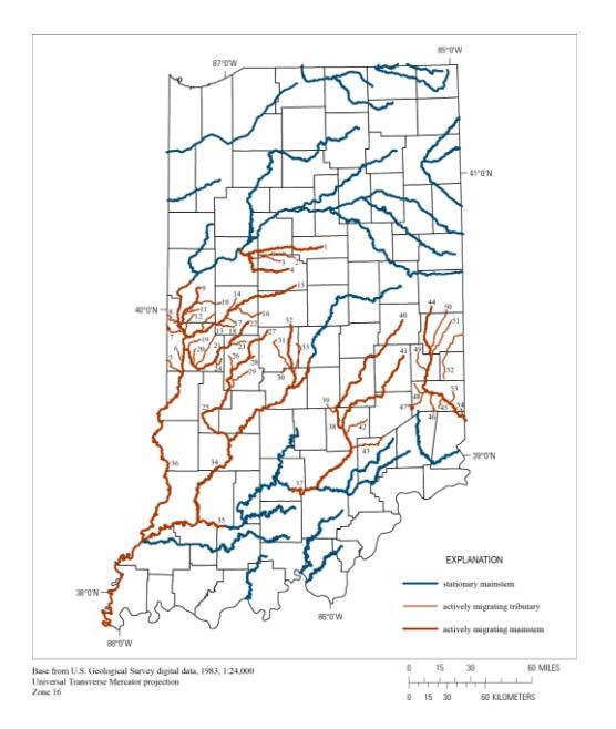
5 Distribution of relatively stationary and actively migrating stream reaches of the 42 drainage basins where channel-migration-rate values were documented in Indiana B. A. Robinson, USGS
6
7 Distribution of channel migration rates for 970 meander bends where channel-migration rates were documented in Indiana (B. A. Robinson, U. S. Geological Survey)
8 The 75th percentile channel-migration rate for the 42 stream reaches where channel-migration-rate values were documented in Indiana (B.A. Robinson, USGS)

9 Meander-Vulnerable Assets White River near Centerton, Ind. Transportation Assets Bridges Roads Railroads Railroad Bridges Utility Assets Power Lines Pipelines Dams Water-treatment Plants B. A. Robinson, U.S. Geological Survey Google Earth TM


10 B. A. Robinson, U.S. Geological Survey

11 Data set includes: 1,128 Assets Asset Class Latitude Longitude Stream Proximity Asset name Ownership B. A. Robinson, U.S. Geological Survey
")

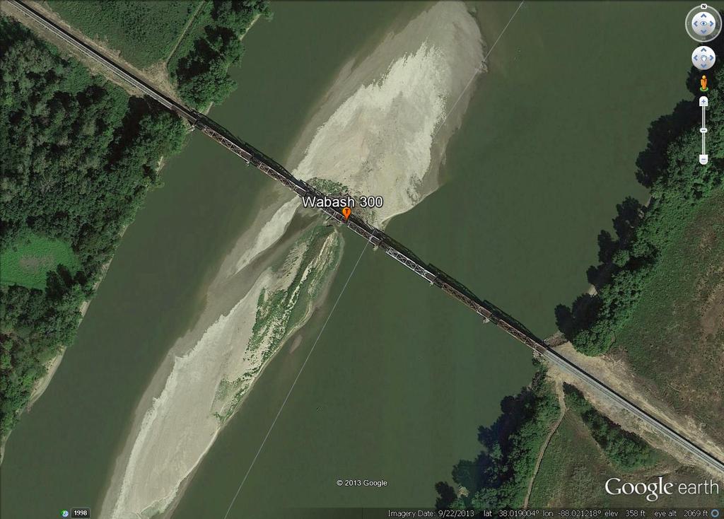
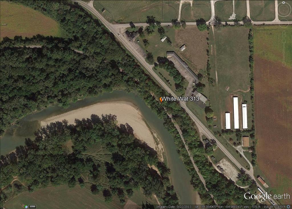
12 Buried Pipelines (Natural Gas & Oil) Actively Migrating Streams (16) Migrating Tributaries (38 not shown) 141 Crossings B. A. Robinson, U.S. Geological Survey
13 Eight counties account for 57% of vulnerable assets Putnam Parke Franklin Hendricks Morgan Shelby Knox Tippecanoe B. A. Robinson, U.S. Geological Survey

14 White River at US 37, near Martinsville, Morgan County, Indiana

15 Beacon Run at US 40, near Brazil, Putnam County, Indiana Note rotational slump (yellow arrow)

16 Whitewater River at Levee Road, near Brookville, Franklin County, Indiana
17 Lessons from White Lick Creek, Hendricks County, Indiana
18 White Lick Creek at SR 267, near Plainfield, Indiana

19 White Lick Creek at SR 267, near Plainfield, Indiana

20 Quaternary geologic map of Indiana Gray, H.H. 1989

21 White Lick Creek at SR 267, near Plainfield, Indiana Indiana 2011/2012 LiDAR
 left bank, yellow arrow indicates SR 267")
22 White Lick Creek at SR 267, near Plainfield, Indiana ( , ) left bank, yellow arrow indicates SR 267

23 White Lick Creek at SR 267, near Plainfield, Indiana ( , ) right bank

24 White Lick Creek at SR 267, near Plainfield, Indiana ( , ) left bank, bank sediment stratigraphy

25 White Lick Creek at SR 267, near Plainfield, Indiana ( , ) downstream

26 White Lick Creek at SR 267, near Plainfield, Indiana ( , ) upstream
27 Managing the Problems
28 Risk Reduction Strategies 1. Stay Away Erosion & channel migration will continue Limit exposure When possible, move infrastructure out of stream corridor Increase mitigation requirements to discourage development in stream corridor Refined Corridor Map Available at: viewer/index.html?id=43e7b307a0184c7c8 51b e2e23 RCB
29 Risk Reduction Strategies 2. More Stringent Development Standards Increase detention requirements (Channel protection volume) Promote / require use of LID & green infrastructure stormwater management strategies Institute riparian corridor with use restrictions RCB


30 Risk Reduction Strategies 3. Improve Planning & Risk Assessment Update regulatory flow rates Improve / update floodplain models Lateral migration monitoring 195 ft 35 ft Change in FEH Status from Channel Migration (Left Image taken 8/29/12; Right image taken 10/17/15, from Google Earth) RCB

31 Risk Reduction Strategies 4. Improve Maintenance & Protect Critical Infrastructure Tree maintenance program Strategic / critical erosion mitigation projects RCB
32 Bottom Line!

33 Things to Remember: Expect continued significant migration within expected erosional corridors SEB


34 Things to Remember: Expect continued significant migration within expected erosional corridors Increase in urbanization within the watershed has exacerbated the issues SEB


35 Things to Remember: Expect continued significant migration within expected erosional corridors Increase in urbanization within the watershed has exacerbated the issues Fixing the problem not likely feasible 1939 SEB

36 Things to Remember: Expect continued significant migration within expected erosional corridors Increase in urbanization within the watershed has exacerbated the issues Fixing the problem not likely feasible The recommended strategies: Multi-jurisdictional Coordination Disturbance Avoidance Zones Channel Protection Volume & GI Detailed Geomorphic Assessment Relocating Threatened Assets Monitoring At-risk Structures Protecting In-place Infrastructure Balanced Tree Management Strategies SEB

37 Riverine Impacts on Transportation Routes in a Nutshell Several Roads and Bridges in Indiana are Vulnerable to Floods and Stream Movement/Erosion Impacts There are ways to Predict, Screen, Monitor, and Prioritize Problem Sites before Potential Service Disruptions Occur A Detailed Morphological Stream Assessment is Crucial in Understanding the Overall System, Understanding the underlying System Stressors, and Making the Right Response and Repair Decisions Early Detection and Mitigation of Problems Saves Time, Money, and Headaches! SEB

38 QUESTIONS? Robert Barr Research Scientist Center for Earth and Environmental Science Department of Earth Sciences IUPUI (office) (mobile) Siavash Beik, PE, CFM, D.WRE Vice President, Principal Engineer Brian Meunier, PE H&H Team Leader Christopher B. Burke Engineering, LLC 115 West Washington Street, Suite 1368 South Indianapolis, IN Ph:
The Yellow River Initiative: The Birth of a System Approach to Challenges Facing the Everglades of the North
 The Yellow River Initiative: The Birth of a System Approach to Challenges Facing the Everglades of the North Robert Barr and Siavash Beik 2016 INAFSM Annual Conference Belterra Conference Center, Indiana
Development of a Fluvial Erosion Hazard Mitigation Program for Indiana
 Development of a Fluvial Erosion Hazard Mitigation Program for Indiana Indiana Watersheds Webinar Series October 12,2011 Robert Barr Center for Earth and Environmental Science Department of Earth Sciences
Stream Geomorphology. Leslie A. Morrissey UVM July 25, 2012
 Stream Geomorphology Leslie A. Morrissey UVM July 25, 2012 What Functions do Healthy Streams Provide? Flood mitigation Water supply Water quality Sediment storage and transport Habitat Recreation Transportation
Appendix C Fluvial Flood Hazards
 Appendix C Fluvial Flood Hazards Sea Level Rise Vulnerability Assessment and Adaptation Project March 2019 Contents Contents... i Figures... i Tables... i Definitions, Acronyms, & Abbreviations... ii
Historical channel change on the Upper Gila River, Arizona and New Mexico in response to anthropogenic modifications and extreme floods
 Historical channel change on the Upper Gila River, Arizona and New Mexico in response to anthropogenic modifications and extreme floods www.archives.gov www.paztcn.wr.usgs.gov wrh.noaa.gov Upper Gila River
Chapter 3 Erosion in the Las Vegas Wash
 Chapter 3 Erosion in the Las Vegas Wash Introduction As described in Chapter 1, the Las Vegas Wash (Wash) has experienced considerable change as a result of development of the Las Vegas Valley (Valley).
Working with Natural Stream Systems
 Working with Natural Stream Systems Graydon Dutcher Delaware County Soil & Water Conservation District Stream Corridor Management Program Tropical Storm Sandy October 29,2012 What is a Watershed?
Programmatic Approaches to Assessing and Mitigating Risk to Pipelines from Natural Forces
 Programmatic Approaches to Assessing and Mitigating Risk to Pipelines from Natural Forces 23 rd International Petroleum Environmental Conference New Orleans, Louisiana November 8-10, 2016 Introduction
CASE STUDIES. Introduction
 Introduction The City of Winston-Salem faces the challenge of maintaining public infrastructure (e.g., water and sewer lines, storm drains, roads, culverts and bridges) while minimizing the potential impacts
Griswold Creek August 22, 2013
 Creek August 22, 2013 1 Lake Erie Protection Fund Creek Study ver Evaluate the overall condition of Creek Determine stable channel dimensions & appropriate restoration techniques Starting Stat gpoint for
CR AAO Bridge. Dead River Flood & Natural Channel Design. Mitch Koetje Water Resources Division UP District
 CR AAO Bridge Dead River Flood & Natural Channel Design Mitch Koetje Water Resources Division UP District Old County Road AAO Bridge Map courtesy of Marquette County Silver Lake Basin McClure Basin
Identifying, Understanding and Addressing Flood-Related Hazards
 Identifying, Understanding and Addressing Flood-Related Hazards Julie Moore, P.E. July 9, 2012 Agenda Traditional approach to river management Understanding flood-related hazards Common flood and flood
The last three sections of the main body of this report consist of:
 Threatened and Endangered Species Geological Hazards Floodplains Cultural Resources Hazardous Materials A Cost Analysis section that provides comparative conceptual-level costs follows the Environmental
May 7, Roger Leventhal, P.E. Marin County Public Works Laurel Collins Watershed Sciences
 May 7, 2013 Roger Leventhal, P.E. Marin County Public Works Laurel Collins Watershed Sciences Background Funded in 2009 under EPA 2100 Grant for $30k and managed by SFEP Project Goals: Update original
Suwannee Satilla Basins Flood Control Issues, Opportunities and Assistance
 Suwannee Satilla Basins Flood Control Issues, Opportunities and Assistance Georgia Silver Jackets Meeting Valdosta, GA April 11, 2013 Presentation Outline Basin overview Recent floods: 2009 100 year flood
How Do Human Impacts and Geomorphological Responses Vary with Spatial Scale in the Streams and Rivers of the Illinois Basin?
 How Do Human Impacts and Geomorphological Responses Vary with Spatial Scale in the Streams and Rivers of the Illinois Basin? Bruce Rhoads Department of Geography University of Illinois at Urbana-Champaign
Swift Creek Sediment Management Action Plan (SCSMAP)
") Swift Creek Sediment Management Action Plan (SCSMAP) PHASE 3 PROJECT PLAN PROPOSAL Whatcom County Public Works Department 322 N. Commercial Street, Suite 210 Bellingham, WA 98225 (360) 676-6692 June 2013
Swift Creek Sediment Management Action Plan (SCSMAP) PHASE 3 PROJECT PLAN PROPOSAL Whatcom County Public Works Department 322 N. Commercial Street, Suite 210 Bellingham, WA 98225 (360) 676-6692 June 2013
STREAM RESTORATION AWRA Summer Specialty Conference, GIS and Water Resources IX
 STREAM RESTORATION 2016 AWRA Summer Specialty Conference, GIS and Water Resources IX Innovative Use of 2D Hydraulic Modeling in Stream Restoration Design Presented by: Li Gao, PE and Robert Scrafford,
SEARCHING FOR SEDIMENT SOURCES IN SPRING CREEK
 SEARCHING FOR SEDIMENT SOURCES IN SPRING CREEK Christopher Frederick, Department of Earth Sciences, University of South Alabama, Mobile, AL 36688. E-mail: cjf702@jaguar1.usouthal.edu. Sediment deposition
SCOPE OF PRESENTATION STREAM DYNAMICS, CHANNEL RESTORATION PLANS, & SEDIMENT TRANSPORT ANALYSES IN RELATION TO RESTORATION PLANS
 DESIGN METHODS B: SEDIMENT TRANSPORT PROCESSES FOR STREAM RESTORATION DESIGN PETER KLINGEMAN OREGON STATE UNIVERSITY CIVIL ENGINEERING DEPT., CORVALLIS 2 ND ANNUAL NORTHWEST STREAM RESTORATION DESIGN SYMPOSIUM
Section 4: Model Development and Application
 Section 4: Model Development and Application The hydrologic model for the Wissahickon Act 167 study was built using GIS layers of land use, hydrologic soil groups, terrain and orthophotography. Within
Swift Creek Sediment Management Action Plan (SCSMAP)
") Swift Creek Sediment Management Action Plan (SCSMAP) PHASE 2 PROJECT PLAN PROPOSAL Whatcom County Public Works Department 322 N. Commercial Street, Suite 210 Bellingham, WA 98225 (360) 676-6692 June 2013
Swift Creek Sediment Management Action Plan (SCSMAP) PHASE 2 PROJECT PLAN PROPOSAL Whatcom County Public Works Department 322 N. Commercial Street, Suite 210 Bellingham, WA 98225 (360) 676-6692 June 2013
Pequabuck River Flooding Study and Flood Mitigation Plan The City of Bristol and Towns of Plainville and Plymouth, CT
 Pequabuck River Flooding Study and Flood Mitigation Plan The City of Bristol and Towns of Plainville and Plymouth, CT Raymond Rogozinski and Maged Aboelata The City of Bristol and Towns of Plainville and
Welcome to NetMap Portal Tutorial
 Welcome to NetMap Portal Tutorial Potential Applications What Can you do with the Portal? At least 25 things! 1) Locate the best potential fish habitats. 2) Identify biological hotspots. 3) Map floodplain
L OWER N OOKSACK R IVER P ROJECT: A LTERNATIVES A NALYSIS A PPENDIX A: H YDRAULIC M ODELING. PREPARED BY: LandC, etc, LLC
 L OWER N OOKSACK R IVER P ROJECT: A LTERNATIVES A NALYSIS A PPENDIX A: H YDRAULIC M ODELING PREPARED BY: LandC, etc, LLC TABLE OF CONTENTS 1 Introduction... 1 2 Methods... 1 2.1 Hydraulic Model... 1 2.2
1 INTRODUCTION AND MAJOR FINDINGS... 1
 Memorandum To: Lindsey Clark, Stillwater Valley Watershed Council Coordinator From: Chad Raisland, Pioneer Technical Services, Inc. and Karin Boyd, Applied Geomorphology, Inc. CC: Tanya Lester, Stillwater
Birch Creek Geomorphic Assessment and Action Plan
 Birch Creek Geomorphic Assessment and Action Plan Jim Webster Tim Hanrahan, PhD, CFM Jesse Schwartz, PhD Zach Hill January 22, 2015 White Eagle Grange This Project is a First Step in Strategy Planning
UPPER COSUMNES RIVER FLOOD MAPPING
 UPPER COSUMNES RIVER FLOOD MAPPING DRAFT BASIC DATA NARRATIVE FLOOD INSURANCE STUDY SACRAMENTO COUTY, CALIFORNIA Community No. 060262 November 2008 Prepared By: CIVIL ENGINEERING SOLUTIONS, INC. 1325 Howe
Opportunities to Improve Ecological Functions of Floodplains and Reduce Flood Risk along Major Rivers in the Puget Sound Basin
 Opportunities to Improve Ecological Functions of Floodplains and Reduce Flood Risk along Major Rivers in the Puget Sound Basin Christopher Konrad, US Geological Survey Tim Beechie, NOAA Fisheries Managing
Black Gore Creek 2013 Sediment Source Monitoring and TMDL Sediment Budget
 Black Gore Creek 2013 Sediment Source Monitoring and TMDL Sediment Budget Prepared for: Prepared By: - I. Introduction The Black Gore Creek Total Maximum Daily Load (TMDL) was developed in collaboration
HYDROLOGIC AND HYDRAULIC REPORT FOR SR. 0522, SECTION 5BN ALONG BLACKLOG CREEK CROMWELL TOWNSHIP HUNTINGDON COUNTY. Prepared for:
 HYDROLOGIC AND HYDRAULIC REPORT FOR SR. 0522, SECTION 5BN ALONG BLACKLOG CREEK CROMWELL TOWNSHIP Prepared for: KCI Technologies, Inc. Mechanicsburg, PA and Pennsylvania Department of Transportation Engineering
Tom Ballestero University of New Hampshire. 1 May 2013
 Tom Ballestero University of New Hampshire 1 May 2013 1 Hydrology 2 Basic Hydrology Low flows most common Flows that fill the stream to the banks and higher are much less common Filling the stream to the
What is a watershed or landscape perspective?
 What is a watershed or landscape perspective? -remove sediment -add sediment -add wood, riparian manipulation -alter (engineer) channel/floodplain morphology -restore/abandon roads You are here What is
Wetland & Floodplain Functional Assessments and Mapping To Protect and Restore Riverine Systems in Vermont. Mike Kline and Laura Lapierre Vermont DEC
 Wetland & Floodplain Functional Assessments and Mapping To Protect and Restore Riverine Systems in Vermont Mike Kline and Laura Lapierre Vermont DEC NWI+ Hydro-Geomorphic Characterization of Wetlands and
When Creek Meets Valley Wall: Prioritizing Erosion Mitigation alongside the Oshawa Landfill
 1 When Creek Meets Valley Wall: Prioritizing Erosion Mitigation alongside the Oshawa Landfill Robin McKillop 1, Dan McParland 1 & Cassie Scobie 2 TRIECA conference March 22-23, 2017 1 Palmer Environmental
Kootenai River Habitat Restoration Program Update
 Kootenai River Habitat Restoration Program Update Kootenai Tribe of Idaho Kootenai Valley Resource Initiative November 19, 2012 Bonners Ferry, Idaho Changes to Kootenai Basin Beaver trapping Floodplain
Assessment. Assessment
 2001 SPRINGBROOK CREEK RESTORATION - THREE YEAR POST-CONSTRUCTION REVIEW - Presented by Bruce Henderson and Andy Harris 2005 River Restoration Northwest Symposium Skamania Lodge, Washington www.hendersonlandservices.com
RAILWAYS AND FISH: HOW TO PROTECT AND ENHANCE FISH HABITAT VALUES AT STREAM CROSSINGS THROUGH PROJECT DESIGN AND CONSTRUCTION
 RAILWAYS AND FISH: HOW TO PROTECT AND ENHANCE FISH HABITAT VALUES AT STREAM CROSSINGS THROUGH PROJECT DESIGN AND CONSTRUCTION Rail Environment Conference November 2016 AGENDA Objective Background Benefits
Frequently Asked Questions about River Corridors
 Frequently Asked Questions about River Corridors 1. What are river corridors and why are they important? ANR River Corridors encompass the area of land surrounding a river that provides for the meandering,
Why Geomorphology for Fish Passage
 Channel Morphology - Stream Crossing Interactions An Overview Michael Love Michael Love & Associates mlove@h2odesigns.com (707) 476-8938 Why Geomorphology for Fish Passage 1. Understand the Scale of the
GEOMORPHIC CHANGES IN LOWER CACHE CREEK 2012
 GEOMORPHIC CHANGES IN LOWER CACHE CREEK 2012 Eric W. Larsen Technical Memorandum Prepared for Cache Creek Technical Advisory Committee Natural Resources Program Yolo County Board of Supervisors 2012 Prepared
Avoiding Geohazards in the Mid-Atlantic Highlands by Using Natural Stream Principles
 Avoiding Geohazards in the Mid-Atlantic Highlands by Using Natural Stream Principles J. Steven Kite, WVU Neal Carte, WVDOT Will Harman, Michael Baker Corp. Donald D. Gray, WVU Photo: W. Gillespie North
AASHTO Extreme Weather Events Symposium Vermont s Road and Rivers - Managing for the Future
 AASHTO Extreme Weather Events Symposium Vermont s Road and Rivers - Managing for the Future May 22, 2013 PLANET EARTH 2 2 MANY MANYYEARS AGO 23,000 years ago there was more than 8,000 feet of glacier over
!"#$%&&'()*+#$%(,-./0*)%(!
*+#$%(,-./0*)%(!") 8:30 Sign in Hoosic River Revival Coalition!"#$%&&'()*+#$%(,-./0*)%(! 12-#30+4/#"5-(60 9:00 Welcome and Introductions 9:15 Goals for Today s Program: A Description of the Planning Process 9:30 First Session:
8:30 Sign in Hoosic River Revival Coalition!"#$%&&'()*+#$%(,-./0*)%(! 12-#30+4/#"5-(60 9:00 Welcome and Introductions 9:15 Goals for Today s Program: A Description of the Planning Process 9:30 First Session:
Fluvial Driven Alluvial Fans
 Fluvial Driven Alluvial Fans Restoration Project Evaluations - Examples from the Russian and Napa River Watersheds Mia Docto Masters Thesis UC Berkeley 1. Basic Fan Description 2. Fluvial Driven Fan Characteristics
APPENDIX A REACH DECRIPTIONS. Quantico Creek Watershed Assessment April 2011
 APPENDIX A REACH DECRIPTIONS Basin 615, South Fork of Quantico Creek - Project Reach Descriptions Reach Name: 615-A Coordinates (NAD 83, Virginia State Plane North): 11796510.57, 6893938.95 to 11801555.79,
PENNSYLVANIA DEPARTMENT OF TRANSPORTATION ENGINEERING DISTRICT 3-0
 PENNSYLVANIA DEPARTMENT OF TRANSPORTATION ENGINEERING DISTRICT 3-0 LYCOMING COUNTY S.R.15, SECTION C41 FINAL HYDROLOGIC AND HYDRAULIC REPORT STEAM VALLEY RUN STREAM RELOCATION DATE: June, 2006 REVISED:
Learning Objectives: I can identify and interpret river flows and directions.
 Learning Objectives: I can identify and interpret river flows and directions. Bellringer Review: Check for Understanding Questions: 1 2 What Are The Key Parts Of A River s Anatomy? In your data notebooks
4.9 GEOLOGY AND SOILS
 4.9 GEOLOGY AND SOILS 4.9.1 EXISTING CONDITIONS TOPOGRAPHY AND RELIEF Zone 40 is located in the central portion of Sacramento County. The topography of the county is represented by three physiographic
Restoration Goals TFG Meeting. Agenda
 San Joaquin River Restoration Program Restoration Goals TFG Meeting Reach 2B Update April 28, 2010 Agenda 1. Introductions 2. Program Restoration Goal Context 3. Program Update a) Interim Flows b) EIS/EIR
3.11 Floodplains Existing Conditions
 Other stormwater control practices may be needed to mitigate water quality impacts. In addition to detention facilities, other practices such as vegetated basins/buffers, infiltration basins, and bioswales
A SIMPLE GIS METHOD FOR OBTAINING FLOODED AREAS
 A SIMPLE GIS METHOD FOR OBTAINING FLOODED AREAS ROMAN P., I. 1, OROS C., R. 2 ABSTRACT. A simple GIS method for obtaining flooded areas. This paper presents a method for obtaining flooded areas near to
KENTUCKY HAZARD MITIGATION PLAN RISK ASSESSMENT
 KENTUCKY HAZARD MITIGATION PLAN RISK ASSESSMENT Presentation Outline Development of the 2013 State Hazard Mitigation Plan Risk Assessment Determining risk assessment scale Census Data Aggregation Levels
Intense Precipitation Events and Flooding
 Intense Precipitation Events and Flooding Climate Disruption & Our Water Future: Mitigate, Adapt or Suffer A Call for New Strategies Middle Rio Grande Water Assembly Saturday, March 21, 2015 Michael Jensen
Carmel River Bank Stabilization at Rancho San Carlos Road Project Description and Work Plan March 2018
 Carmel River Bank Stabilization at Rancho San Carlos Road Project Description and Work Plan March 2018 EXISTING CONDITION The proposed Carmel River Bank Stabilization at Rancho San Carlos Road Project
Dolores River Watershed Study
 CHAPTER 4: RIVER AND FLOODPLAIN ISSUES The Dolores River falls into a category of streams in Colorado that share some unique characteristics. Like some other mountain streams in the state, it has a steep
Four Mile Run Levee Corridor Stream Restoration
 Four Mile Run Levee Corridor Stream Restoration 30% Design Summary U.S. Army Corps of Engineers, Baltimore District Presentation Outline Four Mile Run 1.) Historic Perspective 2.) Existing Conditions 3.)
Chapter 6 Mapping and Online Tools
 Chapter 6 Mapping and Online Tools The stream site you monitor is just part of a much larger system. When analyzing stream health, it is important to take a holistic view by considering the entire watershed.
GOAL 7 AREAS SUBJECT TO NATURAL DISASTERS AND HAZARDS. To protect life and property from natural disasters and hazards.
 GOAL 7 AREAS SUBJECT TO NATURAL DISASTERS AND HAZARDS A. GOALS: To protect life and property from natural disasters and hazards. B. POLICIES: 1. Floodplains shall be maintained as natural drainage-ways.
The River Restoration Centre therrc.co.uk. Understanding Fluvial Processes: supporting River Restoration. Dr Jenny Mant
 The River Restoration Centre therrc.co.uk Understanding Fluvial Processes: supporting River Restoration Dr Jenny Mant Jenny@therrc.co.uk Understanding your catchment Hydrology Energy associated with the
Why Stabilizing the Stream As-Is is Not Enough
 Why Stabilizing the Stream As-Is is Not Enough Several examples of alternatives to the County s design approach have been suggested. A common theme of these proposals is a less comprehensive effort focusing
Thinking Outside the Box (Culvert) Making difficult decisions for Fish Passage. Dave Stewart Oregon Department of Fish and Wildlife
 Making difficult decisions for Fish Passage. Dave Stewart Oregon Department of Fish and Wildlife") Thinking Outside the Box (Culvert) Making difficult decisions for Fish Passage Dave Stewart Oregon Department of Fish and Wildlife Overview Fish Passage History Fast Version Where are we at Now Approval
Thinking Outside the Box (Culvert) Making difficult decisions for Fish Passage Dave Stewart Oregon Department of Fish and Wildlife Overview Fish Passage History Fast Version Where are we at Now Approval
Stream Restoration and Environmental River Mechanics. Objectives. Pierre Y. Julien. 1. Peligre Dam in Haiti (deforestation)
") Stream Restoration and Environmental River Mechanics Pierre Y. Julien Malaysia 2004 Objectives Brief overview of environmental river mechanics and stream restoration: 1. Typical problems in environmental
Stream Restoration and Environmental River Mechanics Pierre Y. Julien Malaysia 2004 Objectives Brief overview of environmental river mechanics and stream restoration: 1. Typical problems in environmental
 Red River Flooding June 2015 Caddo and Bossier Parishes Presented by: Flood Technical Committee Where the Rain Falls Matters I-30 versus I-20 I-20 Backwater and Tributary Floods (Localized) 2016 Flood
Sacramento River Bank Protection Project
 2005 - FIELD RECONNAISSANCE REPORT OF BANK EROSION SITES - SACRAMENTO RIVER FLOOD CONTROL LEVEES AND TRIBUTARIES Sacramento River Bank Protection Project Project No. 32-0530.10, Task 3 Prepared for: U.S.
APPENDIX B Hydraulic Considerations for Pipeline Crossings of Stream Channels
 APPENDIX B Hydraulic Considerations for Pipeline Crossings of Stream Channels B-1 B-2 APPENDIX B HYDRAULIC CONSIDERATIONS FOR PIPELINE CROSSINGS OF STREAM CHANNELS Pipeline crossings of perennial, intermittent,
Flood Frequency and Hazard Analysis of Santa Barbara s Mission Creek
 Flood Frequency and Hazard Analysis of Santa Barbara s Mission Creek Dylan Berry Andrew Donnelly Bruce Stevenson Dr. Professor Ed Keller ES 144: Rivers UC Santa Barbara Spring 2013 Abstract: The objective
GENERAL SUMMARY BIG WOOD RIVER GEOMORPHIC ASSESSMENT BLAINE COUNTY, IDAHO
 GENERAL SUMMARY BIG WOOD RIVER GEOMORPHIC ASSESSMENT BLAINE COUNTY, IDAHO Prepared For Trout Unlimited 300 North Main Street, Hailey, Idaho, 83333 Prepared By P. O. Box 8578, 140 E. Broadway, Suite 23,
CITY OF TUSCALOOSA ORGANIZATION OF 2015 FMP FLOODPLAIN MANAGEMENT PLAN
 CITY OF TUSCALOOSA FLOODPLAIN MANAGEMENT PLAN FMPC Meeting #2 July 8, 2015 ORGANIZATION OF 2015 FMP 2015 Floodplain Management Plan Structure Chapter 1 Introduction Chapter 2 Community Profile Chapter
10/8/ W01. Daniel Catiglione First Gulf Corporation 3751 Victoria Park Avenue Toronto, ON M1W 3Z4
 10/8/2014 Daniel Catiglione First Gulf Corporation 3751 Victoria Park Avenue Toronto, ON M1W 3Z4 Dear Sir, Subject: Lower Morrison Creek Meander Belt Width Assessment MMM was retained by First Gulf Corporation
NORTHUMBERLAND COUNTY, PA
 QUAKER RUN Stream and Wetland Restoration As-Built Completion Report and First Year Monitoring Data Coal Township NORTHUMBERLAND COUNTY, PA Upstream Before Upstream After Prepared for: COAL TOWNSHIP 805
Sediment and nutrient transport and storage along the urban stream corridor
 Sediment and nutrient transport and storage along the urban stream corridor Greg Noe, Cliff Hupp, Ed Schenk, Jackie Batson, Nancy Rybicki, Allen Gellis What is the role of floodplains everywhere? Noe 2013,
Extreme Weather Events
 Extreme Weather Events DOT Lessons Learned For the Resilient & Sustainable Transportation Systems Program M A Y 2 0 1 7 What is resiliency? AASHTO DEFINITION: The ability to prepare and plan for, absorb,
Sixteen Mile Creek Tributaries Meander Belt Width Assessment November 2009
 SIXTEEN MILE CREEK TRIBUTARIES THE CATHOLIC CEMETERIES OF THE DIOCESE OF HAMILTON -MEANDER BELT WIDTH ASSESSMENT - Report to: Attention: From: Director of Cemeteries Catholic Cemeteries of the Diocese
Illinois State Water Survey Division
 Illinois State Water Survey Division SURFACE WATER SECTION SWS Miscellaneous Publication 108 SEDIMENT YIELD AND ACCUMULATION IN THE LOWER CACHE RIVER by Misganaw Demissie Champaign, Illinois June 1989
OBJECTIVES. Fluvial Geomorphology? STREAM CLASSIFICATION & RIVER ASSESSMENT
 STREAM CLASSIFICATION & RIVER ASSESSMENT Greg Babbit Graduate Research Assistant Dept. Forestry, Wildlife & Fisheries Seneca Creek, Monongahela National Forest, West Virginia OBJECTIVES Introduce basic
Earth Science Chapter 6 Section 2 Review
 Name: Class: Date: Earth Science Chapter 6 Section Review Multiple Choice Identify the choice that best completes the statement or answers the question. 1. Most streams carry the largest part of their
Massachusetts Rivers & Roads Training
 Massachusetts Rivers & Roads Training Using Fluvial Geomorphology (FGM) to Reduce Conflicts Between Transportation Assets and Rivers Roy Schiff, Jessica Louisos, and Jim MacBroom, Milone & MacBroom Tim
ARMSTRONG COUNTY, PA
 ARMSTRONG COUNTY, PA Revised Preliminary DFIRM Mapping March 31, 2013 Kevin Donnelly, P.E., CFM GG3, Greenhorne & O Mara, Inc. Presentation Agenda Armstrong County DFIRM Overview - June 25, 2010 DFIRM
Bank Erosion and Morphology of the Kaskaskia River
 Bank Erosion and Morphology of the Kaskaskia River US Army Corps Of Engineers St. Louis District Fayette County Soil and Water Conservation District Team Partners : Carlyle Lake Ecosystem Partnership Vicinity
Climate Risk Visualization for Adaptation Planning and Emergency Response
 Climate Risk Visualization for Adaptation Planning and Emergency Response NCR Flood Fact Finding Workshop Ricardo Saavedra ricardo@vizonomy.com Social Media, Mobile, and Big Data St. Peter s Basilica,
EFFECTS OF RIPARIAN RETENTION (IN WATERSHEDS) ON ALLUVIAL FANS
 ON ALLUVIAL FANS") EFFECTS OF RIPARIAN RETENTION (IN WATERSHEDS) ON ALLUVIAL FANS TIM GILES GEOMORPHOLOGIST FLNRO EFFECTS OF RIPARIAN RETENTION (IN WATERSHEDS) ON ALLUVIAL FANS Description of alluvial fans Three case studies
EFFECTS OF RIPARIAN RETENTION (IN WATERSHEDS) ON ALLUVIAL FANS TIM GILES GEOMORPHOLOGIST FLNRO EFFECTS OF RIPARIAN RETENTION (IN WATERSHEDS) ON ALLUVIAL FANS Description of alluvial fans Three case studies
Field Trip Number One. By: Pat Dryer. Geography 360
 Field Trip Number One By: Pat Dryer Geography 360 Table of Contents Introduction. Page 1 Stop One... Page 2 Stop Two... Page 4 Stop Three... Page 5 Stop Four... Page 7 Bibliography Page 8 Campus Map Source:
CASE STUDY #9 - Brushy Fork Dam, Sugar Grove, West Virginia
 CASE STUDY #9 - Brushy Fork Dam, Sugar Grove, West Virginia Brushy Fork Dam is a flood control structure built by the Soil Conservation Service southeast of the city of Franklin in Pendleton County, West
CITY OF VESTAVIA HILLS
 CITY OF VESTAVIA HILLS FLOODPLAIN MANAGEMENT PLAN FMPC Meeting #3 September 29, 2015 ORGANIZATION OF 2015 FMP 2015 Floodplain Management Plan Structure Chapter 1 Introduction Chapter 2 Community Profile
Diagnostic Geomorphic Methods for Understanding Future Behavior of Lake Superior Streams What Have We Learned in Two Decades?
 Diagnostic Geomorphic Methods for Understanding Future Behavior of Lake Superior Streams What Have We Learned in Two Decades? Faith Fitzpatrick USGS WI Water Science Center, Middleton, WI fafitzpa@usgs.gov
Conceptual Model of Stream Flow Processes for the Russian River Watershed. Chris Farrar
 Conceptual Model of Stream Flow Processes for the Russian River Watershed Chris Farrar Several features of creeks affect the interactions between surface and groundwater. This conceptual model uses the
Predicting Erosion Impact on Highway and Railway Bridge Substructures
 Predicting Erosion Impact on Highway and Railway Bridge Charles T. Swann, R.P.G. Mississippi Mineral Resources Institute 111 Brevard Hall University, Mississippi Christopher L. Mullen Department of Civil
THE TRINITY RIVER VISION/ GATEWAY PARK / PANTHER ISLAND
 Quarterly Project Status Report May 2018 THE TRINITY RIVER VISION/ GATEWAY PARK / PANTHER ISLAND Flood Control Project Update Construction of North Main Street Bridge by TxDOT s bridge contractor, Texas
Dam Removal Analysis Guidelines for Sediment
 A review of: Dam Removal Analysis Guidelines for Sediment Joe Rathbun (Retired) rathbunj@sbcglobal.net Some Potential Sediment Issues Reservoir restoration Downstream water quality Downstream deposition
Red River Levee Panel
 Red River Levee Panel Mississippi River Commission Monday, August 9, 2017 Red River Levees in LA & AR NONE along TX & OK Boarder Red River Levee Issues Caddo Levee Cherokee Park Authorization Bossier Levee
3.12 Geology and Topography Affected Environment
 3 Affected Environment and Environmental Consequences 3.12 Geology and Topography 3.12.1 Affected Environment 3.12.1.1 Earthquakes Sterling Highway MP 45 60 Project Draft SEIS The Kenai Peninsula is predisposed
Use of Space-for-Time Substitution in River Restoration: examples from SE England
 Use of Space-for-Time Substitution in River Restoration: examples from SE England Drs Andrew Brookes and Niamh Burke (Jacobs) Lizzie Rhymes and Graham Scholey (Environment Agency, SE) What is Space-for-Time
The Effects of Flooding on Structures. Or What to Expect when the Drought Ends Violently
 The Effects of Flooding on Structures Or What to Expect when the Drought Ends Violently Let s Define Flood Increase in discharge compared to normal level Direct runoff of rainfall (we re talking about
Geomorphology Studies
 Geomorphology Studies Technical Workgroup Meeting February 14, 2012 Prepared by: Tetra Tech Prepared for: Alaska Energy Authority Overall Goal Geomorphology Studies Two studies Geomorphology Study (RSP
Minimizing Flood Risks and Habitat Impacts Due to Post-Flood Recovery Efforts
 Minimizing Flood Risks and Habitat Impacts Due to Post-Flood Recovery Efforts Roy Schiff, Milone & MacBroom, Inc. Mike Kline, Vermont Agency of Natural Resources Shayne Jaquith, Vermont Agency of Natural
Great Lakes Tributary Modeling: Canaseraga Creek Watershed
 Great Lakes Tributary Modeling: Canaseraga Creek Watershed SWAT Model Authority: Section 516(e) of WRDA 1996 US Army Corps of Engineers Canaseraga Creek Project Location - Encompasses portions of Livingston,
Implementing a Project with 319 Funds: The Spring Brook Meander Project. Leslie A. Berns
 Implementing a Project with 319 Funds: The Spring Brook Meander Project Leslie A. Berns "...to acquire... and hold lands... for the purpose of protecting and preserving the flora, fauna and scenic beauties...
City of Manitou Springs
 March 2018 City of Manitou Springs Implementing Land Use tools to reduce and mitigate natural hazard risk Context & History Past Present Historic homes Older infrastructure Hillside development Creekside
FUTURE MEANDER BEND MIGRATION AND FLOODPLAIN DEVELOPMENT PATTERNS NEAR RIVER MILES 200 TO 191 OF THE SACRAMENTO RIVER PHASE III REPORT
 FUTURE MEANDER BEND MIGRATION AND FLOODPLAIN DEVELOPMENT PATTERNS NEAR RIVER MILES 200 TO 191 OF THE SACRAMENTO RIVER PHASE III REPORT Eric W. Larsen REPORT FOR DUCKS UNLIMITED March 31, 2006-1 - Contents