CAIAG actions on high elevation observations in Kyrgyzstan
|
|
|
- Rachel Jackson
- 5 years ago
- Views:
Transcription


1 CAIAG actions on high elevation observations in Kyrgyzstan

2

3

4 Project structure


5 Aim of the project Water in Central Asia covers study of principal components of the water resources in Kyrgyzstan. One of them is focused on glaciers. Research activities of glaciers were carried out both by field methods as installation of ablation rods, measurements of topographical parameters using GPS by georadar, and through decoding of space images. Results: Within CAWa project in 2010 research activities on the Golubin glacier and Ak-Shyirak area were conducted; as well as installation of ablation rods and measurements of ablation level. Jointly with specialists from GFZ measurements of ice thickness were conducted using georadar. According to the results of decoding of space images, levels of the glacier tongue retreat were obtained.


6
 in 2012: 0.")
7 Balance by results for 2011 Aug 2012 Accumulation: +63g/cm2, ablation: g/cm2 Discharge (ablation) in 2012: 0.59 m3/sec or 0,018 km3/year

8 412 m = 0,014 sq.km/year = 0,013 Abramov glacier regime = 0,027 G.Glazyrin, G.Kamnianski = 0,077 F.Pertsiger, = +0, = +0, = 0, = CAIAG = 0, = 0, m Glacier Abramov 1978


9 The Naryn River basin


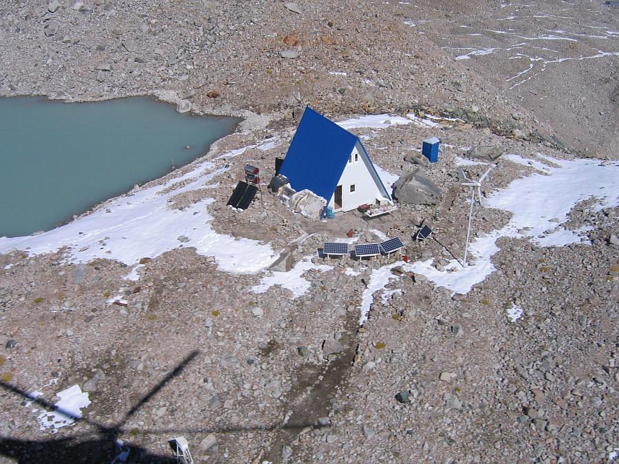
10 Desertification Floods Loss of biodiversity Earthquakes Landslides Ice dam bursts


11


12 Meteorological, seismic and GPS stations, hydro posts for monitoring the lake dynamics Data transfer from remote sensors is carried out using modems via satellite channel by VSAT.


13 Geological-geomorphological, hydrological, meteorological, glaciological research activities in the Inylchek river valley within the GCO project Aim of the project Study and monitoring of the Inylchek glacier for defining its balance, morphological, dynamic characteristics, as well as climatic and hydrological conditions was a study of the glacier using ground and remote methods for defining its dynamics and water balance. Results: In a number of field and theoretical research had being conducted within GCO project. Climatic, hydrological, glaciological factual material on the Sary-Djaz, Inylchek river basins and Inylchek glacier, obtained in the previous years, was classified. Field activities enabled to examine geomorphological features of the Inylchek river valley, lithological composition of ancient glaciological sediments, collect ground samples, ancient soil for following analysis of the genesis and age of these sediments. At the present time hydrological, meteorological and glaciological measurements are carried out on the Mertzbacher station base, created by CAIAG jointly with GFZ. Preliminary results on characteristics of the South and North Inylchek glaciers are obtained by specialists from GFZ.


14 In stakes were drilled In stakes were drilled Ablation stakes of 2012


15 Installation of ablation stakes and ablation measurements Based on the ALOS/PRISM data of 2006, after the lake outburst the DEM was built according to which contours of the terrain were generated.

16 Surface ice velocity on the Western and Southern Enylchek Glaciers
 - ASAI (Aksai) - MRZ1 (Merzbacher) - KRGT (Kerege-Tash) + EDGE - KRBK (Kara-Batkak) + EDGE - TKUM (Tash-Komur) + EDGE - ARSL (Arslanbob) - BIS2 (Bishkek; GFZ & CAIAG")
17 CAWa: Meteo+GNSS +VSAT - BAYT (Baytik) GCO: Meteo + GNSS + VSAT GNSS: Smart (VSAT+seismo Seismology: (Network Caremon): - SUFI (Sufikurgan) + meteo + GNSS): - TARA (Taragai) - ENEL (Enelchek) - ASAI (Aksai) - MRZ1 (Merzbacher) - KRGT (Kerege-Tash) + EDGE - KRBK (Kara-Batkak) + EDGE - TKUM (Tash-Komur) + EDGE - ARSL (Arslanbob) - BIS2 (Bishkek; GFZ & CAIAG station )


18 aresdnlhgioftp Kokomeren Automatic Hi tech Easy to maintain Autonomous system of power supply Power supply management Data transfer in real time mode Remote control Different sensors Abramov glacier


19 Meteorological sensors: Air temperature Air humidity Atmospheric pressure Wind speed and direction Precipitations Solar radiation / radiation balance Soil temperature Taragai Hydrological sensors: Water level River flow Depth of snow cover Density of snow cover Water equivalent of snow cover Water content in soil Dupuli

")
")
")
20 Extension of the observation network Ak-Say smart station(asai) Keregetash GNSS station (KRGT) Kokomeren meteostation(keki) Complex station on the Inylchek Glacier (MRZ1)


21 Observation network developing in the GLOF field

22
Monitoring and study of glacier systems in Kyrgyzstan under conditions of climate change (under the CAWa and GCO projects)
") Central Asian Institute of Applied Geosciences Joint NASA LCLUC Science Team Meeting with GOFC-GOLD CARIN, NEESPI and MAIRS on Land Use and Water Resources in Central Asia Monitoring and study of glacier
Central Asian Institute of Applied Geosciences Joint NASA LCLUC Science Team Meeting with GOFC-GOLD CARIN, NEESPI and MAIRS on Land Use and Water Resources in Central Asia Monitoring and study of glacier
Central Asian Institute for Applied Geosciences: one year with Sentinel Asia
 Central Asian Institute for Applied Geosciences: one year with Sentinel Asia http://www.caiag.kg Dr. B.Moldobekov DPN and JPTM 2010 for Sentinel Asia STEP-2 5-8 July 2010, Manila, Philippines Concept of
International Workshop on the Northern Eurasia High Mountain Ecosystems.
 International Workshop on the Northern Eurasia High Mountain Ecosystems B.Moldobekov, H.Echtler HEchtler http://www.caiag.kg Bishkek, Kyrgyzstan September 8-15, 2009 GFZ: Focus on Central Asia 1992 Space
The CAWa Project. CA High Elevation Research
 The CAWa Project A New Potential for Cooperation in CA High Elevation Research Katy Unger-Shayesteh & Gerd Rücker CAWa Project Coordination Outline CAWa Project Overview Selected Activities Hydrometeorological
Scientific component of Berlin Process (CAWa Project)
") Regional Research Network Central Asian Water Scientific component of Berlin Process (CAWa Project) Almas Kitapbayev, Abror Gafurov, Sarah Schönbrodt-Stitt, Lars Gerlitz Tashkent, 24.11.2017 CAWa Project
Regional Research Network Central Asian Water Scientific component of Berlin Process (CAWa Project) Almas Kitapbayev, Abror Gafurov, Sarah Schönbrodt-Stitt, Lars Gerlitz Tashkent, 24.11.2017 CAWa Project
Supplementary Materials for
 advances.sciencemag.org/cgi/content/full/3/12/e1701169/dc1 Supplementary Materials for Abrupt shift in the observed runoff from the southwestern Greenland ice sheet Andreas P. Ahlstrøm, Dorthe Petersen,
Report on cryosphere related activity in Uzbekistan.
 Report on cryosphere related activity in Uzbekistan. CryoNet Asia Workshop (The second Session) Salekhard, 2 5 February 2016 Klimentiy Valiev Centre of Hydrometeorological Service at Cabinet of Ministers
Cryosphere matters attribution of observed streamflow changes in headwater catchments of the Tarim River
 Cryosphere matters attribution of observed streamflow changes in headwater catchments of the Tarim River Doris Düthmann, Tobias Bolch *, Tino Pieczonka *, Daniel Farinotti, David Kriegel, Sergiy Vorogushyn,
China Physiographi hi i c v ew of N l epa India
 JMA/WMO Workshop on Quality Management in Surface, Climate and Upper-Air Observations in RA II (ASIA) Tokyo, Japan, 27-30 July 2010 Rajendra P. Shrestha Meteorological Forecasting Division Department of
Impact of climate and water resources changes on land degradation in Tajikistan
 Impact of climate and water resources changes on land degradation in Tajikistan Alexander Finaev Institute of Water Issues, Hydro Power Engineering and Ecology, Academy of Sciences, Republic of Tajikistan
Down-stream process transition (f (q s ) = 1)
 = 1)") Down-stream process transition (f (q s ) = 1) Detachment Limited S d >> S t Transport Limited Channel Gradient (m/m) 10-1 Stochastic Variation { Detachment Limited Equilibrium Slope S d = k sd A -θ d S
Down-stream process transition (f (q s ) = 1) Detachment Limited S d >> S t Transport Limited Channel Gradient (m/m) 10-1 Stochastic Variation { Detachment Limited Equilibrium Slope S d = k sd A -θ d S
RADAR Remote Sensing Application Examples
 RADAR Remote Sensing Application Examples! All-weather capability: Microwave penetrates clouds! Construction of short-interval time series through cloud cover - crop-growth cycle! Roughness - Land cover,
Towards more integrated research and observation in the Alps. The Bavarian Academy of Sciences and Humanities and its
 Towards more integrated research and observation in the Alps The Bavarian Academy of Sciences and Humanities and its Commission i for Glaciology l Our activities in Alpine Research Towards more integrated
Why modelling? Glacier mass balance modelling
 Why modelling? Glacier mass balance modelling GEO 4420 Glaciology 12.10.2006 Thomas V. Schuler t.v.schuler@geo.uio.no global mean temperature Background Glaciers have retreated world-wide during the last
Glaciology (as opposed to Glacial Geology) Why important? What are glaciers? How do they work?
 Why important? What are glaciers? How do they work?") Glaciology (as opposed to Glacial Geology) Why important? What are glaciers? How do they work? Glaciers are important because of their role in creating glacial landscapes (erosional and depositional features).
Glaciology (as opposed to Glacial Geology) Why important? What are glaciers? How do they work? Glaciers are important because of their role in creating glacial landscapes (erosional and depositional features).
Central Asia High Elevation International Geophysical (HEIG) Project, since 2015
 Project, since 2015") Central Asia High Elevation International Geophysical (HEIG) Project, since 2015 Under auspices of UNESCO: the International Geoscience Programme (IGCP), the US, Japan, Germany, China, France, Kazakhstan,
Central Asia High Elevation International Geophysical (HEIG) Project, since 2015 Under auspices of UNESCO: the International Geoscience Programme (IGCP), the US, Japan, Germany, China, France, Kazakhstan,
Snowcover accumulation and soil temperature at sites in the western Canadian Arctic
 Snowcover accumulation and soil temperature at sites in the western Canadian Arctic Philip Marsh 1, C. Cuell 1, S. Endrizzi 1, M. Sturm 2, M. Russell 1, C. Onclin 1, and J. Pomeroy 3 1. National Hydrology
Geography Class XI Fundamentals of Physical Geography Section A Total Periods : 140 Total Marks : 70. Periods Topic Subject Matter Geographical Skills
 Geography Class XI Fundamentals of Physical Geography Section A Total Periods : 140 Total Marks : 70 Sr. No. 01 Periods Topic Subject Matter Geographical Skills Nature and Scope Definition, nature, i)
2 nd Asia CryoNet Workshop Current methods of measurement of the cryosphere in Asia consistency and issues
 2 nd Asia CryoNet Workshop Current methods of measurement of the cryosphere in Asia consistency and issues Dongqi Zhang, Cunde Xiao, Vladimir Aizen and Wolfgang Schöner Feb.5, 2016, Salekhard, Russia 1.
ENVIRONMENTAL GEOSCIENCE UNIFORM SYLLABUS
 ENVIRONMENTAL GEOSCIENCE UNIFORM SYLLABUS The Association of Professional Engineers and Geoscientists of the Province of British Columbia Note: 1. This Syllabus May Be Subject To Change 2. These Courses
SNOW AND GLACIER HYDROLOGY
 SNOW AND GLACIER HYDROLOGY by PRATAP SINGH National Institute of Hydrology, Roorkee, India and VIJAY P. SINGH Department of Civil and Environmental Engineering, Louisiana State University, Baton Rouge,
mountain rivers fixed channel boundaries (bedrock banks and bed) high transport capacity low storage input output
 high transport capacity low storage input output") mountain rivers fixed channel boundaries (bedrock banks and bed) high transport capacity low storage input output strong interaction between streams & hillslopes Sediment Budgets for Mountain Rivers Little
mountain rivers fixed channel boundaries (bedrock banks and bed) high transport capacity low storage input output strong interaction between streams & hillslopes Sediment Budgets for Mountain Rivers Little
UIB Network - TWG 5 Hazards and risks:
 UIB Network - TWG 5 Hazards and risks: Philippus Wester & Muhammad Asif Khan ICIMOD & Karakoram International university TWG-5 members: Arun Shrestha, Liu Shiyin, Nusrat Nasab, Deedar Karim, Muhammad Zafar
Comparative analysis of data collected by installed automated meteorological stations and manual data in Central Asia.
 Comparative analysis of data collected by installed automated meteorological stations and manual data in Central Asia. Merkushkin Aleksandr Uzhydromet 71 K. Makhsumov str., 100052 Tashkent, Uzbekistan
How to manage risk through integrated geohazard assessment. Prof. John M. Reynolds Reynolds International Ltd, Mold, UK
 How to manage risk through integrated geohazard assessment Prof. John M. Reynolds Reynolds International Ltd, Mold, UK Talk outline Introduction Types of disasters within the Himalayas Integrated Geohazard
Fundamentals of THE PHYSICAL ENVIRONMENT. David Briggs, Peter Smithson, Kenneth Addison and Ken Atkinson
 Fundamentals of THE PHYSICAL ENVIRONMENT Second Edition David Briggs, Peter Smithson, Kenneth Addison and Ken Atkinson LONDON AND NEW YORK Contents L,ISI Of colour piates List of black and white plates
Analysis of current trends in climate parameters, river discharge and glaciers in the Aksu River basin (Central Asia)
") Publisher: Taylor & Francis & IAHS Press Journal: Hydrological Sciences Journal DOI: 10.1080/02626667.2014.925559 Analysis of current trends in climate parameters, river discharge and glaciers in the Aksu
Publisher: Taylor & Francis & IAHS Press Journal: Hydrological Sciences Journal DOI: 10.1080/02626667.2014.925559 Analysis of current trends in climate parameters, river discharge and glaciers in the Aksu
Data challenges in Trans-boundary River Basins: Case Study of the Upper Indus Basin
 Data challenges in Trans-boundary River Basins: Case Study of the Upper Indus Basin Asif Khan Lead Author (Water chapter- AR6 IPCC) Post Doctorate (Water-Energy-Food-Climate Change, IIASA, Austria) PhD
GIS Techniques for Floodplain Delineation. Dean Djokic
 GIS Techniques for Floodplain Delineation Dean Djokic (ddjokic@esri.com) Content What is a floodplain? How to get a floodplain? What can GIS do for floodplain modeling? Simple GIS techniques for floodplain
Inter-linkage case study in Pakistan
 7 th GEOSS Asia Pacific Symposium GEOSS AWCI Parallel Session: 26-28 May, 2014, Tokyo, Japan Inter-linkage case study in Pakistan Snow and glaciermelt runoff modeling in Upper Indus Basin of Pakistan Maheswor
GEOSPATIAL ANALYSIS OF GLACIAL DYNAMICS OF SHIGAR AND SHAYOK BASINS. Syed Naseem Abbas Gilany 1
 GEOSPATIAL ANALYSIS OF GLACIAL DYNAMICS OF SHIGAR AND SHAYOK BASINS 1 OUTLINE Introduction Problem Statement / Rationale Objectives Material and Methods Study Area Datasets Required Data Analysis / Assessment
MANAGEMENT OF THE NIEMEN RIVER BASIN WITH ACCOUNT OF ADAPTATION TO CLIMATE CHANGE. Hydro-meteorological Monitoring System
 MANAGEMENT OF THE NIEMEN RIVER BASIN WITH ACCOUNT OF ADAPTATION TO CLIMATE CHANGE Hydro-meteorological Monitoring System Draft Interim Report Milestone 1 Giovanni Crema 18 October 2012 Scope of work assessment
MODERN TECHNOLOGIES IN HYDRO-METEOROLOGICAL INFORMATION SYSTEMS
 MODERN TECHNOLOGIES IN HYDRO-METEOROLOGICAL INFORMATION SYSTEMS MARK HEGGLI, INNOVATIVE HYDROLOGY CONSULTING METEOROLOGIST/HYDROLOGIST TO THE WORLD BANK AREAS OF TECHNOLOGY ADVANCEMENT RECENT TECHNOLOGY
Estimating Glacial Volume on the Tibetan Plateau: A Combination Approach of Numerical Modeling and Remote Sensing
 Estimating Glacial Volume on the Tibetan Plateau: A Combination Approach of Numerical Modeling and Remote Sensing Introduction The retreat of the Antarctic and Greenland ice sheets, as well as that of
DISASTER HAZARDS IN BHUTAN By Tshewang Rinzin January Reducing Disaster Risks for a Safe and Happy Bhutan
 DISASTER HAZARDS IN BHUTAN By Tshewang Rinzin 26-27 January 2009 Reducing Disaster Risks for a Safe and Happy Bhutan Disaster Hazards in Bhutan Earthquakes Glacial Lake Outburst Flood (GLOF) Floods in
Role of Hydro-Met Services in Disaster Risk Management
 Role of Hydro-Met Services in Disaster Risk Management Tshewang Rigzin (Mr) National Centre for Hydrology and Meteorology, Bhutan 30 th November 2017 Outline Vision and Mission Functions related to Disaster
Background. Points of Discussion. Hydrographic Models
 Airborne Laser Remote Sensing Technology: Providing Essential Hydrologic Information in the 21 st Century Warwick Hadley, Optech Incorporated Presented by: Warwick Hadley Sales Manager, Middle East and
Chapter 4 Hydrodynamic Modelling of Glacial Lake Outburst Floods
 Chapter 4 Hydrodynamic Modelling of Glacial Lake Outburst Floods To better understand the impacts that a GLOF can have on the downstream valleys, an attempt was made to simulate one GLOF event each in
Waterbury Dam Disturbance Mike Fitzgerald Devin Rowland
 Waterbury Dam Disturbance Mike Fitzgerald Devin Rowland Abstract The Waterbury Dam was completed in October 1938 as a method of flood control in the Winooski Valley. The construction began in April1935
Novel Snotel Data Uses: Detecting Change in Snowpack Development Controls, and Remote Basin Snow Depth Modeling
 Novel Snotel Data Uses: Detecting Change in Snowpack Development Controls, and Remote Basin Snow Depth Modeling OVERVIEW Mark Losleben and Tyler Erickson INSTAAR, University of Colorado Mountain Research
Effects of forest cover and environmental variables on snow accumulation and melt
 Effects of forest cover and environmental variables on snow accumulation and melt Mariana Dobre, William J. Elliot, Joan Q. Wu, Timothy E. Link, Ina S. Miller Abstract The goal of this study was to assess
UGRC 144 Science and Technology in Our Lives/Geohazards
 UGRC 144 Science and Technology in Our Lives/Geohazards Flood and Flood Hazards Dr. Patrick Asamoah Sakyi Department of Earth Science, UG, Legon College of Education School of Continuing and Distance Education
Recent studies and plans on subjects related to NEESPI at JAMSTEC and other Japanese plans
 Recent studies and plans on subjects related to NEESPI at JAMSTEC and other Japanese plans Tetsuo Ohata Program Director IORGC/JAMSTEC, Yokosuka, Japan REGIONAL WATER CYCLE C SNOW COVER P E R C http://www.jamstec.go.jp
TRAINING ON GLACIER STUDIES AND REMOTE SENSING
 1 TRAINING ON GLACIER STUDIES AND REMOTE SENSING Sponsored by June 04-14, 2018 Divecha Centre for Climate Change, Indian Institute of Science, Bengaluru 560 012 Introduction Glaciers, ice and seasonal
Glacier Monitoring: WAPDA s Initiative in the Upper Indus Basin
 Pakistan Water and Power Development Authority (WAPDA) Glacier Monitoring & Research Centre Glacier Monitoring: WAPDA s Initiative in the Upper Indus Basin Asim Rauf Khan, Project Director GMRC WAPDA 17-18
HYDROLOGICAL MODELING OF HIGHLY GLACIERIZED RIVER BASINS. Nina Omani, Raghavan Srinivasan, Patricia Smith, Raghupathy Karthikeyan, Gerald North
 HYDROLOGICAL MODELING OF HIGHLY GLACIERIZED RIVER BASINS Nina Omani, Raghavan Srinivasan, Patricia Smith, Raghupathy Karthikeyan, Gerald North Problem statement Glaciers help to keep the earth cool High
Earth Science. Explain how Earth's biogeochemical cycles create a balance of materials. Examine the importance of biogeochemical cycles.
 Unit 1: DYNAMIC STRUCTURE OF EARTH Introduction to Understand that earth science is based upon the four sciences of astronomy, geology, meteorology, and oceanography. Identify topics studied within the
NIDIS Intermountain West Drought Early Warning System May 23, 2017
 NIDIS Drought and Water Assessment NIDIS Intermountain West Drought Early Warning System May 23, 2017 Precipitation The images above use daily precipitation statistics from NWS COOP, CoCoRaHS, and CoAgMet
ESTIMATING SNOWMELT CONTRIBUTION FROM THE GANGOTRI GLACIER CATCHMENT INTO THE BHAGIRATHI RIVER, INDIA ABSTRACT INTRODUCTION
 ESTIMATING SNOWMELT CONTRIBUTION FROM THE GANGOTRI GLACIER CATCHMENT INTO THE BHAGIRATHI RIVER, INDIA Rodney M. Chai 1, Leigh A. Stearns 2, C. J. van der Veen 1 ABSTRACT The Bhagirathi River emerges from
CAWa Central Asian Water. Training Course Geographical Information Systems in Hydrology
 CAWa Central Asian Water Training Course Geographical Information Systems in Hydrology 1 Place & Time Place to hold the workshop: Helmholtz Centre Potsdam GFZ German Research Center for Geosciences, Germany
Course Description. Course Objectives and Standards
 Earth and Space Science Curriculum Course Description Earth and Space Science 1 State # 3044 Grades offered: 10-12 Credits: A two credit course Prerequisite: none Counts as a Science Course for the General,
Joseph M. Shea 1, R. Dan Moore, Faron S. Anslow University of British Columbia, Vancouver, BC, Canada. 1 Introduction
 17th Conference on Applied Climatology, American Meteorological Society, 11-1 August, 28, Whistler, BC, Canada P2. - Estimating meteorological variables within glacier boundary layers, Southern Coast Mountains,
Tropical Montane Cloud Forests: Importance and Challenges in a Changing Environment
 Tropical Montane Cloud Forests: Importance and Challenges in a Changing Environment Daniel E. Comarazamy and Jorge E. González The NOAA-CREST Center & Department of Mechanical Engineering, City College
Hydrological change in the. regions of Central Asia
 Hydrological change in the mountainous and downstream regions of Central Asia Alexander I. Shiklomanov Water Systems Analysis Group University of New Hampshire International Workshop on the Northern Eurasia
Coping with International Water Conflict in Central Asia ~ Implications of Climate Change and Melting Ice in the Syr Darya Catchment *
 Coping with International Water Conflict in Central Asia ~ Implications of Climate Change and Melting Ice in the Syr Darya Catchment * *: Partially funded by NOAA CORC ARCHES. Tobias Siegfried, Thomas
Sediment production in Tuni lake catchment due to climate change
 Sediment production in Tuni lake catchment due to climate change (Proyecto Grande/Erosión y Sedimentación) Ramiro Pillco Zolá &, Seiki Kawagoe, Vanesa Vera San Andres Major University, Bolivia Fukushima
Sediment dynamics and sub-recent sediment budget of the braided sandur system at Sandane, Erdalen (Nordfjord, western Norway)
") Sediment dynamics and sub-recent sediment budget of the braided sandur system at Sandane, Erdalen (Nordfjord, western Norway) A.A. Beylich (1,2), L. Hansen (1), S. Liermann (3), D. Gintz (3), K. Laute
Sediment dynamics and sub-recent sediment budget of the braided sandur system at Sandane, Erdalen (Nordfjord, western Norway) A.A. Beylich (1,2), L. Hansen (1), S. Liermann (3), D. Gintz (3), K. Laute
Using Morphometric models and Open Source Software to locate Flood prone areas A guide to pilot Implementation
 SciNetNatHaz Project Progress Meeting - 23-26 Oct 2014, Burgas, Bulgaria SciNetNatHaz Project Progress Meeting - 7-9 May 2015, Thessaloniki, Hellas Using Morphometric models and Open Source Software to
Paper presented in the Annual Meeting of Association of American Geographers, Las Vegas, USA, March 2009 ABSTRACT
 Paper presented in the Annual Meeting of Association of American Geographers, Las Vegas, USA, March 2009 ABSTRACT CHANGING GEOMORPHOLOGY OF THE KOSI RIVER SYSTEM IN THE INDIAN SUBCONTINENT Nupur Bose,
Spring break reading. Glacial formation. Surface processes: Glaciers and deserts. The Control of Nature
 suggested Spring break reading The Control of Nature by John McPhee Surface processes: Glaciers and deserts describes our efforts to control three natural hazards: 1. The Mississippi Floods 2. The Heimaey
GEOCHEMISTRY UNIFORM SYLLABUS
 GEOCHEMISTRY UNIFORM SYLLABUS The Association of Professional Engineers and Geoscientists of the Province of British Columbia Note: 1. This Syllabus May Be Subject To Change 2. These Courses Are Required
Bhutan Country Report for JPTM 2010 (July, 2010) Department of Disaster Management Ministry of Home & Cultural Affairs Royal Government of Bhutan
 Department of Disaster Management Ministry of Home & Cultural Affairs Royal Government of Bhutan") Bhutan Country Report for JPTM 2010 (July, 2010) Department of Disaster Management Ministry of Home & Cultural Affairs Royal Government of Bhutan 1 Contents of Presentation 1. Disaster Hazards and Underlying
Bhutan Country Report for JPTM 2010 (July, 2010) Department of Disaster Management Ministry of Home & Cultural Affairs Royal Government of Bhutan 1 Contents of Presentation 1. Disaster Hazards and Underlying
Science EOG Review: Landforms
 Mathematician Science EOG Review: Landforms Vocabulary Definition Term canyon deep, large, V- shaped valley formed by a river over millions of years of erosion; sometimes called gorges (example: Linville
Country Report Nepal Geospatial Data Sharing Initiatives of Survey Department Supporting Disaster Management
 Third JPTM Step 2 for Sentinel Asia 6-8 July, 2010 Manila, The Philippines Country Report Nepal Geospatial Data Sharing Initiatives of Survey Department Supporting Disaster Management Durgendra M Kayastha
Topic 6: Weathering, Erosion and Erosional-Deposition Systems (workbook p ) Workbook Chapter 4, 5 WEATHERING
 Workbook Chapter 4, 5 WEATHERING") Topic 6: Weathering, Erosion and Erosional-Deposition Systems (workbook p. 95-125) Workbook Chapter 4, 5 THE BIG PICTURE: Weathering, erosion and deposition are processes that cause changes to rock material
Topic 6: Weathering, Erosion and Erosional-Deposition Systems (workbook p. 95-125) Workbook Chapter 4, 5 THE BIG PICTURE: Weathering, erosion and deposition are processes that cause changes to rock material
Debris flow: categories, characteristics, hazard assessment, mitigation measures. Hariklia D. SKILODIMOU, George D. BATHRELLOS
 Debris flow: categories, characteristics, hazard assessment, mitigation measures Hariklia D. SKILODIMOU, George D. BATHRELLOS Natural hazards: physical phenomena, active in geological time capable of producing
MODELLING FUTURE CHANGES IN CRYOSPHERE OF INDUS BASIN
 MODELLING FUTURE CHANGES IN CRYOSPHERE OF INDUS BASIN ANIL V. KULKARNI DISTINGUISHED VISITING SCIENTIST DIVECHA CENTRE FOR CLIMATE CHANGE INDIAN INSTITUTE OF SCIENCE BANGALORE 560012 INDIA Presented at
Using MODIS imagery to validate the spatial representation of snow cover extent obtained from SWAT in a data-scarce Chilean Andean watershed
 Using MODIS imagery to validate the spatial representation of snow cover extent obtained from SWAT in a data-scarce Chilean Andean watershed Alejandra Stehr 1, Oscar Link 2, Mauricio Aguayo 1 1 Centro
Modeling of a River Basin Using SWAT Model and SUFI-2
 Modeling of a River Basin Using SWAT Model and SUFI-2 NINA OMANI MASOUD TAJRISHY AHMAD ABRISHAMCHI Sharif University of Technology, Tehran, Iran Karkheh Dam, Iran 1 Area of Gharasu Sub-basin : 5793 km2
Class Notes: Surface Processes
 Name: Date: Period: Surface Processes The Physical Setting: Earth Science Class Notes: Surface Processes I. Weathering and Soils Weathering -! Sediments -! Weathering occurs when rocks are exposed to:
Mountain Rivers. Gutta cavat lapidem. (Dripping water hollows out a stone) -Ovid, Epistulae Ex Ponto, Book 3, no. 10, 1. 5
 -Ovid, Epistulae Ex Ponto, Book 3, no. 10, 1. 5") Mountain Rivers Gutta cavat lapidem (Dripping water hollows out a stone) -Ovid, Epistulae Ex Ponto, Book 3, no. 10, 1. 5 Mountain Rivers Fixed channel boundaries (bedrock banks and bed) High transport
Mountain Rivers Gutta cavat lapidem (Dripping water hollows out a stone) -Ovid, Epistulae Ex Ponto, Book 3, no. 10, 1. 5 Mountain Rivers Fixed channel boundaries (bedrock banks and bed) High transport
Earthquake Emergency Preparedness in Central-Hungary
 UN-SPIDER Fourth United Nations International UN-SPIDER Bonn Workshop on Disaster Management and Space Technology: The 4C Challenge:Communication Coordination Cooperation Capacity Development Bonn, Germany,
The Arctic Sea Ice Cover
 The Arctic Sea Ice Cover From the Living Earth Interface, Impediment, Integrator Frozen ocean 8-15 million km 2 Size of U.S. Meters thick Floating, moving ice Highly variable Large albedo Climate change!
Page 1. Name:
 Name: 1) Which property would best distinguish sediment deposited by a river from sediment deposited by a glacier? thickness of sediment layers age of fossils found in the sediment mineral composition
Presentation on HYDROLOGICAL & METEOROLOGICAL SERVICE OF NEPAL
 International Workshop on Socio-Economic Benefits of Hydrological & Meteorological Services 21-28 28 September 2009 Presentation on HYDROLOGICAL & METEOROLOGICAL SERVICE OF NEPAL by Suresh Maskey Hydrologist
Subject Classification
 Istituto Nazionale di Geofisica e Vulcanologia earth-prints home page roma library bologna library catania library milano library napoli library palerm Subject Classification Earth-prints organize its
APPLICATIONS OF DOWNSCALING: HYDROLOGY AND WATER RESOURCES EXAMPLES
 APPLICATIONS OF DOWNSCALING: HYDROLOGY AND WATER RESOURCES EXAMPLES Dennis P. Lettenmaier Department of Civil and Environmental Engineering For presentation at Workshop on Regional Climate Research NCAR
Assessment of solid load and siltation potential of dams reservoirs in the High Atlas of Marrakech (Moorcco) using SWAT Model
 using SWAT Model") Assessment of solid load and siltation potential of dams reservoirs in the High Atlas of Marrakech (Moorcco) using SWAT Model Amal Markhi: Phd Student Supervisor: Pr :N.Laftrouhi Contextualization Facing
Assessment of solid load and siltation potential of dams reservoirs in the High Atlas of Marrakech (Moorcco) using SWAT Model Amal Markhi: Phd Student Supervisor: Pr :N.Laftrouhi Contextualization Facing
Annexure I. SCIENTIFIC AND LOGISTICS OBJECTIVES OF THE 30 th INDIAN SCIENTIFIC ANTARCTIC EXPEDITION
 Annexure I SCIENTIFIC AND LOGISTICS OBJECTIVES OF THE 30 th INDIAN SCIENTIFIC ANTARCTIC EXPEDITION Investigation of magnetospheric-ionospheric coupling between high and low latitudes related to space weather
Landslide monitoring system in Iceland. Harpa Grímsdóttir Jón Kristinn Helgason NVE, Oslo, October
 Landslide monitoring system in Iceland Harpa Grímsdóttir Jón Kristinn Helgason NVE, Oslo, October 26 2016 History Avalanches and landslides have caused extensive damages and loss of human lives in Iceland
Geomorphology for Engineers
 Geomorphology for Engineers Edited by P. G. Fookes, E. M. Lee and G. Milligan Whittles Publishing CRC PRESS Contents Foreword Preface Dedication Biographies 1. Introduction to Engineering Geomorphology
Steve Colwell. British Antarctic Survey
 Global Climate Observing System (GCOS) Steve Colwell British Antarctic Survey Goal and Structure of GCOS The Goal of GCOS is to provide continuous, reliable, comprehensive data and information on the state
The Official CA State Science Education Standards for Earth Science K 8
 The Official CA State Science Education Standards for Earth Science K 8 Kindergarten The Earth is composed of land, air and water. As a basis for understanding this concept, students know: a. characteristics
PROANA A USEFUL SOFTWARE FOR TERRAIN ANALYSIS AND GEOENVIRONMENTAL APPLICATIONS STUDY CASE ON THE GEODYNAMIC EVOLUTION OF ARGOLIS PENINSULA, GREECE.
 PROANA A USEFUL SOFTWARE FOR TERRAIN ANALYSIS AND GEOENVIRONMENTAL APPLICATIONS STUDY CASE ON THE GEODYNAMIC EVOLUTION OF ARGOLIS PENINSULA, GREECE. Spyridoula Vassilopoulou * Institute of Cartography
Glaciers and climate change Jon Ove Hagen, Department of Geosciences University of Oslo
 Glaciers and climate change Jon Ove Hagen, Department of Geosciences University of Oslo joh@geo.uio.no Department of geosciences, Faculty of Mathematics and Natural Sciences Glaciers and climate change
NIDIS Intermountain West Regional Drought Early Warning System February 7, 2017
 NIDIS Drought and Water Assessment NIDIS Intermountain West Regional Drought Early Warning System February 7, 2017 Precipitation The images above use daily precipitation statistics from NWS COOP, CoCoRaHS,
Flash flood disaster in Bayangol district, Ulaanbaatar
 Flash flood disaster in Bayangol district, Ulaanbaatar Advanced Training Workshop on Reservoir Sedimentation Management 10-16 October 2007. IRTCES, Beijing China Janchivdorj.L, Institute of Geoecology,MAS
Global climate change
 Global climate change What is climate change? This winter was really cold! Temp difference ( C): Jan 2004 vs. Jan 2002-2003 Make your own maps at: http://www.giss.nasa.gov/data/update/gistemp/maps/ 1 What
Water & Climate; Floods & Droughts (The yin & yang of water availablilty) Water & Climate; Floods & Droughts (The yin & yang of water availablilty)
 Water & Climate; Floods & Droughts (The yin & yang of water availablilty)") (Acknowledgment: This presentation was developed in collaboration with ESA, NEON and NCEAS, federal agencies and academic team members from minority serving institutions.) Water & Climate; Floods & Droughts
(Acknowledgment: This presentation was developed in collaboration with ESA, NEON and NCEAS, federal agencies and academic team members from minority serving institutions.) Water & Climate; Floods & Droughts
Using LiDAR as an Oil and Natural Gas Exploration Tool
 Figure 1: The Face of the Matanuska Glacier outside of Palmer Alaska. The Matanuska is a good example of a small retreating alpine glacier. Fractures in the glacier allow meltwater to carry rock and sediment
Sediment Deposition LET THE RIVER RUN T E A C H E R. Activity Overview. Activity at a Glance. Time Required. Level of Complexity.
 Activity at a Glance Grade: 6 9 Subject: Science Category: Physical Science, Earth Science Topic: Deposition, River Systems Time Required Two 45-minute periods Level of Complexity Medium Materials* TI-73
THE ACTION OF GLACIERS
 Surface processes THE ACTION OF GLACIERS Glaciers are enormous masses of ice which are formed due to accumulation, compaction and re-crystallisation of the snow deposited in very cold regions (the majority
Impacts of snowpack accumulation and summer weather on alpine glacier hydrology
 Impacts of snowpack accumulation and summer weather on alpine glacier hydrology Caroline Aubry-Wake, Dhiraj Pradhananga, John W. Pomeroy GEWEX 8 th Open Science Meeting, Canmore AB, May 3-11 2018 Canadian
2017 Fall Conditions Report
 2017 Fall Conditions Report Prepared by: Hydrologic Forecast Centre Date: November 15, 2017 Table of Contents TABLE OF FIGURES... ii EXECUTIVE SUMMARY... 1 BACKGROUND... 4 SUMMER AND FALL PRECIPITATION...
Graduate Courses Meteorology / Atmospheric Science UNC Charlotte
 Graduate Courses Meteorology / Atmospheric Science UNC Charlotte In order to inform prospective M.S. Earth Science students as to what graduate-level courses are offered across the broad disciplines of
Re-establishing glacier monitoring in Kyrgyzstan and Uzbekistan, Central Asia
 Re-establishing glacier monitoring in Kyrgyzstan and Uzbekistan, Central Asia Hoelzle Martin 1, Azisov Erlan 2, Barandun Martina 1, Huss Matthias 1,3, Farinotti Daniel 3,4, Gafurov Abror 5, Hagg Wilfried
Operational Aspects of GNSS CORS What is a GNSS CORS system used for?
 Please insert a picture (Insert, Picture, from file). Size according to grey field (10 cm x 25.4 cm). Scale picture: highlight, pull corner point Cut picture: highlight, choose the cutting icon from the
River Response. Sediment Water Wood. Confinement. Bank material. Channel morphology. Valley slope. Riparian vegetation.
 River Response River Response Sediment Water Wood Confinement Valley slope Channel morphology Bank material Flow obstructions Riparian vegetation climate catchment vegetation hydrological regime channel
Glacial Erosion II: Processes, Rates & Landforms. Bernard Hallet ESS
 Glacial Erosion II: Processes, Rates & Landforms Bernard Hallet ESS 685-2409 hallet@u.washington.edu Housekeeping for the day Friday Discussion Section Holiday Friday no discussion session Monday Discussion
Correlation: California State Curriculum Standards of Science for Grade 6 Focus on Earth Science
 Correlation: California State Curriculum Standards of Science for Grade 6 Focus on Earth Science To Science Workshop Series Earth Science: Geology The Universe Oceans and Atmosphere Plate Tectonics and