Presentation on HYDROLOGICAL & METEOROLOGICAL SERVICE OF NEPAL
|
|
|
- Gilbert Short
- 6 years ago
- Views:
Transcription
1 International Workshop on Socio-Economic Benefits of Hydrological & Meteorological Services September 2009 Presentation on HYDROLOGICAL & METEOROLOGICAL SERVICE OF NEPAL by Suresh Maskey Hydrologist Department of Hydrology & Meteorology Kathmandu, Nepal
2 PRSENTATION TOPICS General Features of Nepal Hydrological & Meteorological Scenario Activities of DHM : 1. Hydrology Service 2. Meteorology Service 3. Weather Forecasting 4. Flood Forecasting 5. Snow & Glacier Hydrology
3 Nepal: in the central part of the Hindu- Kush Himalayan region, - Area 147,181 sq km L = 885 km Avg. W = 193 km -Rugged topography, very high relief, variable climatic conditions and complex geological structures with active tectonic processes - 60m to 8848m A.M.S.L
4 CLIMATE Tropical to Alpine +40 to 50 C Wet to Dry 250 to 6000 mm 80% Precipitation during Summer Monsoon
 Karnali 1380 16000 173 Narayani 1150 14000 160 Kosi 1620 9880 200 Bagmati 130 7550")
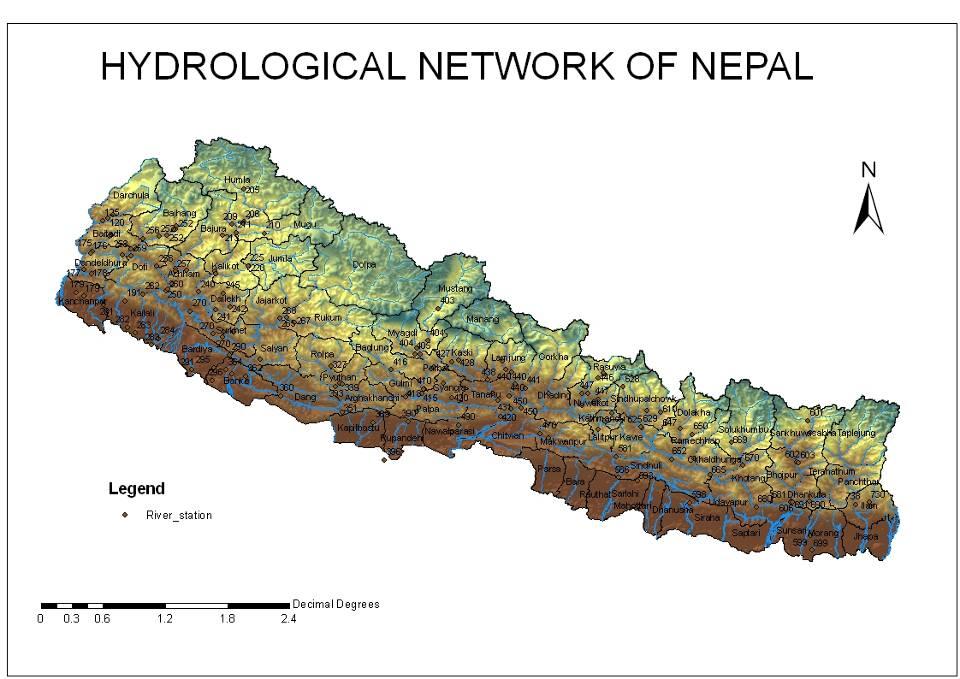
5 Major River Basin of Nepal Major River Yearly Ave (cu.m\sec) Max. (cu.m\sec) Min (cu.m\sec) Karnali Narayani Kosi Bagmati

6 HYDROLOGY 6,000 Rivers & Rivulets Drainage Area = 194,000 Three classes of Rivers Snowfed Rainfed Seasonal

7

8 HYDROPOWER 83,000 MW potential 43,000 MW feasible 527 MW exploited Meets only 2005 demand Access to 40% population
18033 12.")
9 Land use of Nepal Type of land use Area (sq. km) % Forest Agriculture Snow Pasture Water Settlements and Roads Others (waste land, etc) Total 147,

10 Ministry of Environment Department of Hydrology and Meteorology Babar Mahal
11 Division * Meteorology Division * Weather Forecasting Division * Hydrology Division Total staff: 237
12 * Meteorology Division Activities Collection, processing and publication of meteorological data Climate change study Solar and Wind Study Agro-meteorological study

13 Meteorological Stations PRECIPITATION -337 CLIMATOLOGY - 68 AGROMETEOROLOGY - 22 SYNOPTIC - 9 AEROSYNOPTIC - 6 AWS - 18 Total 460

14 DATA PROCESSING


15 Publications Meteorology and Hydrology

16
17 REVENUE Revenue from Data book & Digital data Amount in Rs Met. Data book Met.Digi. Data Hydro.Data Book / / / / / /62 Fiscal year

18 DATA USERS STUDENTS/RESEARCHERS: 74 % CONSULTANT: 12 % INSURANCE : 4 % OTHERS: 10 %
19 Weather Forecasting Division Weather Forecasting Division Airport, Kathmandu


20 Synoptic Station Airport, Kathmandu 15 Synoptic Stations


21 Data Collection & Distribution System Tele-printer Radio AMSS SADIS


22 Plotting & Analysis 6 Surface charts Every 3 hours interval 2 upper air charts Over 8 vertical levels Every 12 hours interval


23 Weather forecasting process Collection of weather data from various parts with the country Collection of weather data from neighboring countries as well as from different parts of world. Weather Forecasting Weather forecasting tools: Weather data from various parts of world Satellite imaginary SADIS Numerical weather prediction outputs from India and other countries Weather information from different parts of world Tools Synoptic Charts Satellite Images NWP Guidance


 TAF")


24 Services Forecast to General Public Twice daily through media Daily update in home page Weather bulletins Briefing to journalists Aviation Sector METAR (every half hour) TAF (every six hours) En-route Forecast Weather Briefing to pilots Mountaineering Forecast Daily Special Forecast for mountaineers
25 Hydrology Division River Hydrology Flood Forecasting Snow and Glacier Hydrology Water Quality & Sediment
26 River Hydrology Main Activities Operation of 164 hydrological stations Collection and Publication of Hydrological Information Lake Study

27


28 Staff Gauge Gauging Station of Manahari Khola Staff Gauge & Gauge House Discharge Measurement by wading Discharge measurement from cable car

29 Cable way site at Melamchi at Helambu


30 Tilicho Lake Lake Study Dhanus and Ganga Sagar Rara Lake Water Quality of Rivers & Lakes Kathmandu and Pokhara Monitoring 52 Stations
31 Flood Forecasting Activities Operation of 20 hydrological and 16 rainfall stations Collection and Publication of data Flood Risk Mapping Model development for Flood forecasting Flood Forecasting in major rivers of Nepal


:")
32 Flood Forecasting Station Network Flood Forecasting Project has now a network of 43 stations in operation: 15 hydrometric stations (Water level + Rainfall) 27 meteorological stations One hydrometric station (Portaha- Bandipur): Rainfall only


33 Flood Forecasting Process Office Siren Station Data News Media New Papers News Papers New Papers Papers Papers Papers Papers Papers New News Papers News Papers New Papers News Papers New Papers News Papers New Papers News Papers New Papers News Papers New Papers News Papers


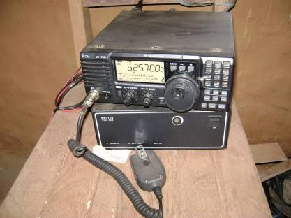
34 Communication Systems
35 Real Time Data Acquisition System Existing HF Transceiver system isn t adequate Less reliable in bad weather conditions Recently, DHM has installed 10 rainfall and 3 water level data loggers in Narayani River basin with Code Division Multiple Access (CDMA) wireless communication system for high speed data transfer. It uses M2M communication technology with CDMA wireless modem to transmit data from sensors placed at different parts over the internet to a database server. The data have been posted on the following website:

36 Transmitted Data

37 Near Sundari Ghat, Bagmati
38 Flood Risk Map of Khando Khola (Saptari) Application of GIS W N S River Settlements Road High Risk Zone Medium Risk Zone Low Risk Zone Watersed Buondary E
39 Activities Snow and Glacier Hydrology Operation of 6 hydrometeorogical stations Collection and Publication of data Glacier and glacier lake studies Model development for snow and glacier melt runoff
40 Snow and Glacier Hydrology Activities Hydrological and meteorological data collection from high Himalayas (Elevation m) Station Elevation River Langtang 3800 m. Langtang Khumbu 4335 m Imja Annapurna 3470 m Modi Makalu 3980 m Barun Kanjiroba 3770 m Sanu Bheri Humla 3800 m Panchamukhi Khola Parameters (i) Temperature (ii) Relative Humidity (iii) Precipitation (iv) Solar radiation (v) Wind speed/ direction (vi) River stage/discharge (vii) Water equivalent of snow


41 Discharge Measurement by Tracer Technology Injection of 90 tracer Sampling 1st Qtr 2nd Qtr 3rd Qtr 4th Qtr Tracer Laboratory East West North


42 Snow survey for determination of water equivalent of snow Snow pit Snow sampler


43 Snow cover Database Management


44 Glacier Retreat in the Nepal Himalayas Rika Samba Glacier, Hidden Valley, Dhaulagiri m Glaciers in Nepal are in general condition of retreat due to climate change SOURCE: GEN/DHM RESEARCH


45 Map of Glaciers and Glacier Lakes Distribution ICIMOD/UNEP (2000)
46 Glaciers of Nepal Major Basin Glacier number Area,km ² Lake number Area,km ² Ice Reserve,km 3 Koshi Gandaki Karnali Mahakali Total


47 Tinau Tinau Khola Khola Training Suspended sampler Bedload sampling Butwal


48 Air Pollution(Babarmahal): WHO Normal: µg/m3 NEPAL Normal: 150 µg/m3 Max.: 727 µg/m3 in May 1995 Min.: 31 µg/m3 in July 1996 Annual Normal: 206 µg/m3 Initial after 24 hrs
49 Conclusion Extension of Hydrological & Meteorological station as user demand Upgrade Manual Station to Automatic Real Time Data transmission System
50
Hydro-meteorological Analysis of Langtang Khola Catchment, Nepal
 Hydro-meteorological Analysis of Langtang Khola Catchment, Nepal Tirtha R. Adhikari 1, Lochan P. Devkota 1, Suresh.C Pradhan 2, Pradeep K. Mool 3 1 Central Department of Hydrology and Meteorology Tribhuvan
China Physiographi hi i c v ew of N l epa India
 JMA/WMO Workshop on Quality Management in Surface, Climate and Upper-Air Observations in RA II (ASIA) Tokyo, Japan, 27-30 July 2010 Rajendra P. Shrestha Meteorological Forecasting Division Department of
South Asia Flash Flood Guidance System Operational Workshop (Step-4)
") South Asia Flash Flood Guidance System Operational Workshop (Step-4) (5 th to 7 th June 2018) Operational Flash Flood Forecasting and Early Warnings Capabilities in Bhutan (Sonam Tashi) Weather Forecaster
South Asia Flash Flood Guidance System Operational Workshop (Step-4) (5 th to 7 th June 2018) Operational Flash Flood Forecasting and Early Warnings Capabilities in Bhutan (Sonam Tashi) Weather Forecaster
Flash flood forecasting and warning infrastructures of National Meteorology and Hydrological Services of Cambodia
 Development and Implementation of the South East Asia Flash Flood Guidance System (SEAFFGS) Ha Noi, Viet Nam, 20-23 November 2017 Flash flood forecasting and warning infrastructures of National Meteorology
The current status, functions, challenges and needs of South Sudan Meteorological Department (SSMD)
") The current status, functions, challenges and needs of South Sudan Meteorological Department (SSMD) Presented: by Mojwok Ogawi Modo, South Sudan Meteorological Department. Background The present SSMD was
The current status, functions, challenges and needs of South Sudan Meteorological Department (SSMD) Presented: by Mojwok Ogawi Modo, South Sudan Meteorological Department. Background The present SSMD was
Hydro-Meteorology of the Country
 Chapter 3 Hydro-Meteorology of the Country 3.1 RIVER BASINS For hydrological studies, Nepal is divided into seven drainage basins: the Kankai Mai River Basin, the Koshi River Basin, the Bagmati River Basin,
Hydrologic Modelling of the Upper Malaprabha Catchment using ArcView SWAT
 Hydrologic Modelling of the Upper Malaprabha Catchment using ArcView SWAT Technical briefs are short summaries of the models used in the project aimed at nontechnical readers. The aim of the PES India
Country Presentation-Nepal
 Country Presentation-Nepal Mt.Everest, Shiva Pd. Nepal, DHM South Asia Drought Monitor Workshop Dhaka Bangladesh 2 th April 215 Overview Brief Climatology Climate activities- DHM PPCR (Pilot Program for
CLIMATE CHANGE ADAPTATION BY MEANS OF PUBLIC PRIVATE PARTNERSHIP TO ESTABLISH EARLY WARNING SYSTEM
 CLIMATE CHANGE ADAPTATION BY MEANS OF PUBLIC PRIVATE PARTNERSHIP TO ESTABLISH EARLY WARNING SYSTEM By: Dr Mamadou Lamine BAH, National Director Direction Nationale de la Meteorologie (DNM), Guinea President,
Regional Flash Flood Guidance and Early Warning System
 WMO Training for Trainers Workshop on Integrated approach to flash flood and flood risk management 24-28 October 2010 Kathmandu, Nepal Regional Flash Flood Guidance and Early Warning System Dr. W. E. Grabs
National Public Weather and Warning Services in the Swaziland Meteorological Service Dennis S.Mkhonta /
 National Public Weather and Warning Services in the Swaziland Meteorological Service Dennis S.Mkhonta dennis.mkhonta@gmail.com / dennis@swazimet.gov.sz Introduction Swaziland s geographical position exposes
Recent extreme weather events in the Nepal Himalayas
 The Extremes ofthe Extremes: Extraordinary Floods (Proceedings of n symposium held al Reykjavik. Iceland. July 2000). lalispubl.no. 271. 2002. 141 Recent extreme weather events in the Nepal Himalayas SURESH
Seasonal and spatial variation of solar radiation in Nepal Himalayas
 1 Seasonal and spatial variation of solar radiation in Nepal Himalayas Sunil Adhikary Department of Meteorology Tri-Chandra Multiple Campus, Tribhuvan University, Kathmandu, Nepal. ABSTRACT Solar radiation
1 Introduction. Station Type No. Synoptic/GTS 17 Principal 172 Ordinary 546 Precipitation
 Use of Automatic Weather Stations in Ethiopia Dula Shanko National Meteorological Agency(NMA), Addis Ababa, Ethiopia Phone: +251116639662, Mob +251911208024 Fax +251116625292, Email: Du_shanko@yahoo.com
Infrastructure and Expertise available to the Advisory Section
 Infrastructure and Expertise available to the Advisory Section By Lucky Nhlanhla Sigudla Advisory Section Outline INTRODUCTION STRUCTURE PRESENT INFRATUCTURE EXPERTISE SPECIFIC ISSUES USER ACTIVITIES CONCLUSION
The Importance of Snowmelt Runoff Modeling for Sustainable Development and Disaster Prevention
 The Importance of Snowmelt Runoff Modeling for Sustainable Development and Disaster Prevention Muzafar Malikov Space Research Centre Academy of Sciences Republic of Uzbekistan Water H 2 O Gas - Water Vapor
Climate Services in Seychelles
 Climate Services in Seychelles Vincent Amelie Seychelles Met. Services Email: v.amelie@meteo.gov.sc Regional Consultation on Climate Services in the Indian Ocean Islands, Ebène, Mauritius, 14-16 March
FOURTH INTERNATIONAL PORT METEOROLOGICAL OFFICERS WORKSHOP AND SUPPORT TO GLOBAL OCEAN OBSERVATIONS USING SHIP LOGISTICS
 FOURTH INTERNATIONAL PORT METEOROLOGICAL OFFICERS WORKSHOP AND SUPPORT TO GLOBAL OCEAN OBSERVATIONS USING SHIP LOGISTICS PMO-IV 8-10 DEC 2010, ORLANDO, FLORIDA, USA 1 This presentation is generally for
Geography Class XI Fundamentals of Physical Geography Section A Total Periods : 140 Total Marks : 70. Periods Topic Subject Matter Geographical Skills
 Geography Class XI Fundamentals of Physical Geography Section A Total Periods : 140 Total Marks : 70 Sr. No. 01 Periods Topic Subject Matter Geographical Skills Nature and Scope Definition, nature, i)
COUNTRY REPORT. Jakarta. July, th National Directorate of Meteorology and Geophysics of Timor-Leste (DNMG)
") The Southeastern Asia-Oceania Flash Flood COUNTRY REPORT Jakarta. July, 10-12 th 2017 National Directorate of Meteorology and Geophysics of Timor-Leste (DNMG) Carla Feritas and Crisostimo Lobato Democratic
The Southeastern Asia-Oceania Flash Flood COUNTRY REPORT Jakarta. July, 10-12 th 2017 National Directorate of Meteorology and Geophysics of Timor-Leste (DNMG) Carla Feritas and Crisostimo Lobato Democratic
Geo-information and Disaster Risk Reduction in the Hindu Kush-Himalayan region
 Geo-information and Disaster Risk Reduction in the Hindu Kush-Himalayan region Basanta Shrestha, Division Head MENRIS, International Centre for Integrated Mountain Development Kathmandu, Nepal The International
FNEP: Finnish-Nepalese Project for improving the meteorological readiness in Nepal
 72 FNEP: Finnish-Nepalese Project for improving the meteorological readiness in Nepal Antti Mäkelä 1*, Irma Ylikangas 1, Ramchandra Karki 2, Kamal Prakash Budhathoki 2, Adriaan Perrels 1, Kristiina Säntti
Training Courses
 Caribbean Institute for Meteorology and Hydrology The Caribbean Institute for Meteorology and Hydrology The Caribbean Institute for Meteorology and Hydrology is the regional Institution mandated to conduct
National Weather Service Flood Forecast Needs: Improved Rainfall Estimates
 National Weather Service Flood Forecast Needs: Improved Rainfall Estimates Weather Forecast Offices Cleveland and Northern Indiana Ohio River Forecast Center Presenter: Sarah Jamison, Service Hydrologist
The known requirements for Arctic climate services
 The known requirements for Arctic climate services based on findings described in STT White paper 8/2015 Johanna Ekman / EC PHORS STT Regional drivers The Arctic region is home to almost four million people
Regional Consultation on Climate Services at the National Level for South East Europe Antalya, Turkey November
 malsale@meteo.gov.vu Regional Consultation on Climate Services at the National Level for South East Europe Antalya, Turkey 21-22 November 2014 n.rudan@rhmzrs.com Capacities for the management of climatic
Recent development of the National Hydro-Meteorological Service (NHMS) of Viet Nam for disaster risk reduction
 of Viet Nam for disaster risk reduction") Ministry of Natural Resources and Environment National Hydro-Meteorological Service Recent development of the National Hydro-Meteorological Service (NHMS) of Viet Nam for disaster risk reduction Tran Van
Ministry of Natural Resources and Environment National Hydro-Meteorological Service Recent development of the National Hydro-Meteorological Service (NHMS) of Viet Nam for disaster risk reduction Tran Van
Global Cryosphere Watch (GCW) Tropical Cryosphere Workshop
 Tropical Cryosphere Workshop") Global Cryosphere Watch (GCW) Tropical Cryosphere Workshop Morocco specific presentation Meriem ALAOURI CNC/DMN Arusha, 4 July 2017 Geographical context Mountains cover more than two thirds of the Moroccan
Global Cryosphere Watch (GCW) Tropical Cryosphere Workshop Morocco specific presentation Meriem ALAOURI CNC/DMN Arusha, 4 July 2017 Geographical context Mountains cover more than two thirds of the Moroccan
Wali Ullah Khan Pakistan Meteorological Department
 An overview of Weather Observation practices over Pakistan By Wali Ullah Khan Pakistan Meteorological Department JMA/WMO TRAINING WORKSHOP ON CALIBRATION AND MAINTENANCE OF METEOROLOGICAL INSTRUMENTS IN
Early Warning System and Role of IMD. Manmohan Singh Meteorological Centre Shimla
 Early Warning System and Role of IMD Manmohan Singh Meteorological Centre Shimla India a land with a unique climatic regime Two monsoon seasons (southwest & northeast monsoons) Two cyclone seasons (pre
Operational water balance model for Siilinjärvi mine
 Operational water balance model for Siilinjärvi mine Vesa Kolhinen, Tiia Vento, Juho Jakkila, Markus Huttunen, Marie Korppoo, Bertel Vehviläinen Finnish Environment Institute (SYKE) Freshwater Centre/Watershed
Wind Resource Assessment Practical Guidance for Developing A Successful Wind Project
 December 11, 2012 Wind Resource Assessment Practical Guidance for Developing A Successful Wind Project Michael C Brower, PhD Chief Technical Officer Presented at: What We Do AWS Truepower partners with
Central Water Commission Ministry of WR,RD & GR. Operational Flood Forecasting
 Central Water Commission Ministry of WR,RD & GR 1 Operational Flood Forecasting Flood Forecasting by CWC 2 The work of flood forecasting and warning in India is entrusted with the Central Water Commission
Report on Disaster statistics of Nepal
 Report on Disaster statistics of Nepal Submitted by Altaf Rehman Submitted to Dr. Naveed Ahmed University of engineering and technology Peshawar Assignment 1 Section A Registration id 14PWCIV456 Page 1
Operational Perspectives on Hydrologic Model Data Assimilation
 Operational Perspectives on Hydrologic Model Data Assimilation Rob Hartman Hydrologist in Charge NOAA / National Weather Service California-Nevada River Forecast Center Sacramento, CA USA Outline Operational
Flood Inundation Mapping under different climate change scenarios in the upper Indus River Basin, Pakistan
 Flood Inundation Mapping under different climate change scenarios in the upper Indus River Basin, Pakistan Sohaib Baig (doctoral student) 16 November 2017 Disaster Prevention Research Institute 1 Kyoto
TONGA COUNTRY REPORT. Officer : John Holi
 TONGA COUNTRY REPORT Officer : John Holi OUTLINES INTRODUCTION BACKGROUND INFORMATION CLIMATE TONGA METEOROLOGICAL SERVICE PROPOSAL INTRODUCTION Location of Tonga Lies between 15 173 W 155 177 W 25.55
HYDROLOGICAL MODELING OF HIGHLY GLACIERIZED RIVER BASINS. Nina Omani, Raghavan Srinivasan, Patricia Smith, Raghupathy Karthikeyan, Gerald North
 HYDROLOGICAL MODELING OF HIGHLY GLACIERIZED RIVER BASINS Nina Omani, Raghavan Srinivasan, Patricia Smith, Raghupathy Karthikeyan, Gerald North Problem statement Glaciers help to keep the earth cool High
Air temperature environment on the debriscovered area of Lirung Glacier, Langtang Valley, Nepal Himalayas
 Debris-Covered Glaciers (Proceedings of a workshop held at Seattle, Washington, USA, September 2000). IAHS Publ. no. 264, 2000. 83 Air temperature environment on the debriscovered area of Lirung Glacier,
Understanding Karnali River Basin. Kabi Raj Khatiwada
 Understanding Karnali River Basin Kabi Raj Khatiwada http://treasuresfromtheroad.com/karnali-river-too-slow-boat/ The asymmetric, single-tower, cable-stayed bridge is the longest of its type in the world
Steering Committee on Global Flash Flood Guidance 29 November 2016, Inter-Continental Hotel, Phnom Penh. Cambodia National Weather Services
 Steering Committee on Global Flash Flood Guidance 29 November 2016, Inter-Continental Hotel, Phnom Penh Cambodia National Weather Services Activities and Responsibilities of Research and Flood Forecasting
Strategic Planning of Tuvalu Meteorological Service
 WMO Regional Seminar on Enhancing Service Delivery by National Meteorological & Hydrological Services (NMHSs( NMHSs) ) in RA V Kuala Lumpur, Malaysia, 2 6 April 2007 Strategic Planning of Tuvalu Meteorological
ANALYSIS OF FLOODS AND DROUGHTS IN THE BAGO RIVER BASIN, MYANMAR, UNDER CLIMATE CHANGE
 ANALYSIS OF FLOODS AND DROUGHTS IN THE BAGO RIVER BASIN, MYANMAR, UNDER CLIMATE CHANGE Myo Myat Thu* MEE15631 ABSTRACT 1 Supervisor: Dr. Maskym Gusyev** Dr. Akira Hasegawa** This study investigates floods
UNIT 11 SOUTH ASIA SG 1 - PHYSICAL GEOGRAPHY & THE ENVIRONMENT
 UNIT 11 SOUTH ASIA SG 1 - PHYSICAL GEOGRAPHY & THE ENVIRONMENT I. PHYSICAL GEOGRAPHY TAKE OUT YOUR PHYSICAL MAP OF SOUTH ASIA A. The Himalayan Mountains form the northern boundary of the region (color
Flood Forecasting Tools for Ungauged Streams in Alberta: Status and Lessons from the Flood of 2013
 Flood Forecasting Tools for Ungauged Streams in Alberta: Status and Lessons from the Flood of 2013 John Pomeroy, Xing Fang, Kevin Shook, Tom Brown Centre for Hydrology, University of Saskatchewan, Saskatoon
Skeletal remains of what was a debris-covered glacier near Mt. Everest
 Annual satellite imaging of the world s glaciers Assessment of glacier extent and change GLIMS Development and population of a digital glacier data inventory HIGH ICE Skeletal remains of what was a debris-covered
National Report on Weather Forecasting Service
 MINISTRY OF WATER RESOURCES AND METEOROLOGY DEPARTMENT OF METEOROLOGY, CAMBODIA National Report on Weather Forecasting Service Tokyo, 11-15 March 2014 Department of Meteorology, Cambodia Presentation Outline
IMPACT OF CLIMATE CHANGE OVER THE ARABIAN PENINSULA
 IMPACT OF CLIMATE CHANGE OVER THE ARABIAN PENINSULA By: Talal Alharbi June, 29 2017 1 Motivation: In arid and semi-arid regions of the world the demand for fresh water resources is increasing due to: increasing
Research highlights from permafrost research: Rock glacier mapping in the HKH region with Google Earth
 Research highlights from permafrost research: Rock glacier mapping in the HKH region with Google Earth M.-O. Schmid, P. Baral, S. Gruber, S. Shahi, T. Shrestha, D. Stumm, and P. Wester International Centre
MANAGEMENT OF THE NIEMEN RIVER BASIN WITH ACCOUNT OF ADAPTATION TO CLIMATE CHANGE. Hydro-meteorological Monitoring System
 MANAGEMENT OF THE NIEMEN RIVER BASIN WITH ACCOUNT OF ADAPTATION TO CLIMATE CHANGE Hydro-meteorological Monitoring System Draft Interim Report Milestone 1 Giovanni Crema 18 October 2012 Scope of work assessment
Country Report Nepal Geospatial Data Sharing Initiatives of Survey Department Supporting Disaster Management
 Third JPTM Step 2 for Sentinel Asia 6-8 July, 2010 Manila, The Philippines Country Report Nepal Geospatial Data Sharing Initiatives of Survey Department Supporting Disaster Management Durgendra M Kayastha
ESTIMATING SNOWMELT CONTRIBUTION FROM THE GANGOTRI GLACIER CATCHMENT INTO THE BHAGIRATHI RIVER, INDIA ABSTRACT INTRODUCTION
 ESTIMATING SNOWMELT CONTRIBUTION FROM THE GANGOTRI GLACIER CATCHMENT INTO THE BHAGIRATHI RIVER, INDIA Rodney M. Chai 1, Leigh A. Stearns 2, C. J. van der Veen 1 ABSTRACT The Bhagirathi River emerges from
REQUIREMENTS FOR WEATHER RADAR DATA. Review of the current and likely future hydrological requirements for Weather Radar data
 WORLD METEOROLOGICAL ORGANIZATION COMMISSION FOR BASIC SYSTEMS OPEN PROGRAMME AREA GROUP ON INTEGRATED OBSERVING SYSTEMS WORKSHOP ON RADAR DATA EXCHANGE EXETER, UK, 24-26 APRIL 2013 CBS/OPAG-IOS/WxR_EXCHANGE/2.3
Introdution. Geography. Country overview
 The 5th Meeting of the Coordinating Group of the RA II WIGOS Satellite Project 21 October, Vladivostok city, Russky Island, Russia Far Eastern Federal University Tajikistan report Agency for Hydrometeorology
Socio-Economic Benefits of Weather, Water & Climate Services
 Socio-Economic Benefits of Weather, Water & Climate Services A Case Study of Pakistan Dr. Qamar-uz-Zaman Chaudhry Director General Pakistan Meteorological Department http://www.pakmet.com.pk Economic benefits
South Asian Climate Outlook Forum (SASCOF-6)
") Sixth Session of South Asian Climate Outlook Forum (SASCOF-6) Dhaka, Bangladesh, 19-22 April 2015 Consensus Statement Summary Below normal rainfall is most likely during the 2015 southwest monsoon season
Sixth Session of South Asian Climate Outlook Forum (SASCOF-6) Dhaka, Bangladesh, 19-22 April 2015 Consensus Statement Summary Below normal rainfall is most likely during the 2015 southwest monsoon season
Training Courses
 Caribbean Institute for Meteorology and Hydrology The Caribbean Institute for Meteorology and Hydrology The Caribbean Institute for Meteorology and Hydrology is the regional Institution mandated to conduct
A Ngari Director Cook Islands Meteorological Service
 WORLD METEOROLOGICAL ORGANIZATION REGIONAL SEMINAR ON CLIMATE SERVICES IN REGIONAL ASSOCIATION V (SOUTH-WEST PACIFIC) Honiara, Solomon Islands, 1-4 November 2011 A Ngari Director Cook Islands Meteorological
the orographic gradient of runoff in the nepal himalaya Abstract
 the orographic gradient of runoff in the nepal himalaya Donald Alford 1831 Poly Drive Billings, Montana USA 59102 Dalford8@aol.com Abstract The hydrologic regime of Himalayan catchment basins is not well-defined.
Climatic Change Implications for Hydrologic Systems in the Sierra Nevada
 Climatic Change Implications for Hydrologic Systems in the Sierra Nevada Part Two: The HSPF Model: Basis For Watershed Yield Calculator Part two presents an an overview of why the hydrologic yield calculator
Steve Colwell. British Antarctic Survey
 Global Climate Observing System (GCOS) Steve Colwell British Antarctic Survey Goal and Structure of GCOS The Goal of GCOS is to provide continuous, reliable, comprehensive data and information on the state
Agrometeorological services in Greece
 Eleftheria Tsiniari Hellenic National Meteorological Service Operational Forecaster MSc in Meteorology MSc in Prevention and Management of Natural Disasters Email: elefth.tsiniari@gmail.com 1 Past (last
Commercialisation. Lessons learned from Dutch weather market
 Commercialisation Lessons learned from Dutch weather market Where information comes together weather traffic public transport Weather, traffic and public transport. Daily actual information that influences
Training Courses 2018
 Caribbean Institute for Meteorology and Hydrology The Caribbean Institute for Meteorology and Hydrology The Caribbean Institute for Meteorology and Hydrology is the regional Institution mandated to conduct
investment decisions
 Climate modelling: A guide to investment decisions Vicky Pope Met Office Hadley Centre This is not an ADB material. The views expressed in this document are the views of the author/s and/or their organizations
July, International SWAT Conference & Workshops
 July, 212 212 International SWAT Conference & Workshops Hydrological Modelling of Kosi and Gandak Basins using SWAT Model S. Dutta, Pritam Biswas, Sangita Devi, Suresh A Karth and Bimlesh kumar, Ganga
Water information system advances American River basin. Roger Bales, Martha Conklin, Steve Glaser, Bob Rice & collaborators UC: SNRI & CITRIS
 Water information system advances American River basin Roger Bales, Martha Conklin, Steve Glaser, Bob Rice & collaborators UC: SNRI & CITRIS Opportunities Unprecedented level of information from low-cost
Speakers: NWS Buffalo Dan Kelly and Sarah Jamison, NERFC Jeane Wallace. NWS Flood Services for the Black River Basin
 Speakers: NWS Buffalo Dan Kelly and Sarah Jamison, NERFC Jeane Wallace NWS Flood Services for the Black River Basin National Weather Service Who We Are The National Oceanic and Atmospheric Administration
International Desks: African Training Desk and Projects
 The Climate Prediction Center International Desks: African Training Desk and Projects Wassila M. Thiaw Team Leader Climate Prediction Center National Centers for Environmental Predictions 1 African Desk
Primary author: Tymvios, Filippos (CMS - Cyprus Meteorological Service, Dpt. of Aeronautical Meteorology),
,") Primary author: Tymvios, Filippos (CMS - Cyprus Meteorological Service, Dpt. of Aeronautical Meteorology), ftymvios@ms.moa.gov.cy Co-author: Marios Theophilou (Cyprus Meteorological Service, Climatology
Primary author: Tymvios, Filippos (CMS - Cyprus Meteorological Service, Dpt. of Aeronautical Meteorology), ftymvios@ms.moa.gov.cy Co-author: Marios Theophilou (Cyprus Meteorological Service, Climatology
Flood Inundation Analysis by Using RRI Model For Chindwin River Basin, Myanmar
 Flood Inundation Analysis by Using RRI Model For Chindwin River Basin, Myanmar Aye Aye Naing Supervisor : Dr. Miho Ohara MEE14625 Dr. Duminda Perera Dr. Yoshihiro Shibuo ABSTRACT Floods occur during the
MONITORING OF SEASONAL SNOW COVER IN YAMUNA BASIN OF UTTARAKAHND HIMALAYA USING REMOTE SENSING TECHNIQUES
 MONITORING OF SEASONAL SNOW COVER IN YAMUNA BASIN OF UTTARAKAHND HIMALAYA USING REMOTE SENSING TECHNIQUES Anju Panwar, Devendra Singh Uttarakhand Space Application Centre, Dehradun, India ABSTRACT Himalaya
Assessment of solid load and siltation potential of dams reservoirs in the High Atlas of Marrakech (Moorcco) using SWAT Model
 using SWAT Model") Assessment of solid load and siltation potential of dams reservoirs in the High Atlas of Marrakech (Moorcco) using SWAT Model Amal Markhi: Phd Student Supervisor: Pr :N.Laftrouhi Contextualization Facing
Assessment of solid load and siltation potential of dams reservoirs in the High Atlas of Marrakech (Moorcco) using SWAT Model Amal Markhi: Phd Student Supervisor: Pr :N.Laftrouhi Contextualization Facing
Inter-linkage case study in Pakistan
 7 th GEOSS Asia Pacific Symposium GEOSS AWCI Parallel Session: 26-28 May, 2014, Tokyo, Japan Inter-linkage case study in Pakistan Snow and glaciermelt runoff modeling in Upper Indus Basin of Pakistan Maheswor
* * * Table (1) Table (2)
 Table (2)") A step Forward to Atomize the Sudan Meteorological Authority (SMA) Net work Y.S. Odan Surface Instruments Department Tel: 00249 912220246 E-mail yaseen@ersad.gov.sd Abstract AWS has been introduced to
A step Forward to Atomize the Sudan Meteorological Authority (SMA) Net work Y.S. Odan Surface Instruments Department Tel: 00249 912220246 E-mail yaseen@ersad.gov.sd Abstract AWS has been introduced to
Application of Satellite Data for Flood Forecasting and Early Warning in the Mekong River Basin in South-east Asia
 MEKONG RIVER COMMISSION Vientiane, Lao PDR Application of Satellite Data for Flood Forecasting and Early Warning in the Mekong River Basin in South-east Asia 4 th World Water Forum March 2006 Mexico City,
Flash Flood Guidance Gazette
 Volume 1, Issue 4 December 2012 Flash Flood Guidance Gazette Flash Flood Guidance (FFG) Gazette, a bi-annual newsletter bringing users of FFG products all the latest news operational information, technical
The National Operational Hydrologic Remote Sensing Center Operational Snow Analysis
 The National Operational Hydrologic Remote Sensing Center Operational Snow Analysis World Meteorological Organization Global Cryosphere Watch Snow-Watch Workshop Session 3: Snow Analysis Products Andrew
Operational Applications of Awos Network in Turkey
 Operational Applications of Awos Network in Turkey by Soner Karatas Turkish State Meteorological Service Electronic Observing Systems Division Kütükcü Alibey Cad. No:4 06120 Kalaba-Ankara-TURKEY Tel:+90-312-302
Waterways from glaciers to coastal waters in Iceland. Jórunn Harðardóttir, IMO Nordic WFD conference September 26, 2012
 Waterways from glaciers to coastal waters in Iceland Jórunn Harðardóttir, IMO Nordic WFD conference September 26, 2012 What to include and what not to include? Hydrology of Iceland Much on glaciers and
NIDIS Intermountain West Regional Drought Early Warning System February 7, 2017
 NIDIS Drought and Water Assessment NIDIS Intermountain West Regional Drought Early Warning System February 7, 2017 Precipitation The images above use daily precipitation statistics from NWS COOP, CoCoRaHS,
GEOGRAPHY (029) CLASS XI ( ) Part A: Fundamentals of Physical Geography. Map and Diagram 5. Part B India-Physical Environment 35 Marks
 CLASS XI ( ) Part A: Fundamentals of Physical Geography. Map and Diagram 5. Part B India-Physical Environment 35 Marks") GEOGRAPHY (029) CLASS XI (207-8) One Theory Paper 70 Marks 3 Hours Part A Fundamentals of Physical Geography 35 Marks Unit-: Geography as a discipline Unit-3: Landforms Unit-4: Climate Unit-5: Water (Oceans)
GEOGRAPHY (029) CLASS XI (207-8) One Theory Paper 70 Marks 3 Hours Part A Fundamentals of Physical Geography 35 Marks Unit-: Geography as a discipline Unit-3: Landforms Unit-4: Climate Unit-5: Water (Oceans)
SEASONAL CLIMATE OUTLOOK VALID FOR JULY-AUGUST- SEPTEMBER 2013 IN WEST AFRICA, CHAD AND CAMEROON
 SEASONAL CLIMATE OUTLOOK VALID FOR JULY-AUGUST- SEPTEMBER 2013 IN WEST AFRICA, CHAD AND CAMEROON May 29, 2013 ABUJA-Federal Republic of Nigeria 1 EXECUTIVE SUMMARY Given the current Sea Surface and sub-surface
EFFICIENCY OF THE INTEGRATED RESERVOIR OPERATION FOR FLOOD CONTROL IN THE UPPER TONE RIVER OF JAPAN CONSIDERING SPATIAL DISTRIBUTION OF RAINFALL
 EFFICIENCY OF THE INTEGRATED RESERVOIR OPERATION FOR FLOOD CONTROL IN THE UPPER TONE RIVER OF JAPAN CONSIDERING SPATIAL DISTRIBUTION OF RAINFALL Dawen YANG, Eik Chay LOW and Toshio KOIKE Department of
Joint Meeting of RA II WIGOS Project and RA V TT-SU on 11 October 2018 BMKG Headquarter Jakarta, Indonesia. Mrs. Sinthaly CHANTHANA
 Joint Meeting of RA II WIGOS Project and RA V TT-SU on 11 October 2018 BMKG Headquarter Jakarta, Indonesia Mrs. Sinthaly CHANTHANA Lao PDR Background Department of Meteorology and Hydrology ( DMH ) in
How to manage risk through integrated geohazard assessment. Prof. John M. Reynolds Reynolds International Ltd, Mold, UK
 How to manage risk through integrated geohazard assessment Prof. John M. Reynolds Reynolds International Ltd, Mold, UK Talk outline Introduction Types of disasters within the Himalayas Integrated Geohazard
MetConsole AWOS. (Automated Weather Observation System) Make the most of your energy SM
 Make the most of your energy SM") MetConsole AWOS (Automated Weather Observation System) Meets your aviation weather needs with inherent flexibility, proven reliability Make the most of your energy SM Automated Weather Observation System
MetConsole AWOS (Automated Weather Observation System) Meets your aviation weather needs with inherent flexibility, proven reliability Make the most of your energy SM Automated Weather Observation System
METEOROLOGICAL SERVICE DELIVERY Mozambique Model
 METEOROLOGICAL SERVICE DELIVERY Mozambique Model MOZAMBIQUE INSTITUTE OF METEOROLOGY (INAM) João Atanasio Manhique National Deputy Director atanasio_m@inam.gov.mz http://www.inam.gov.mz Workshop: Achieving
Introduction to Weather Data Cleaning
 Introduction to Weather Data Cleaning Speedwell Weather Limited An Introduction Providing weather services since 1999 Largest private-sector database of world-wide historic weather data Major provider
IMS4 AWOS. Automated Weather Observation System. Integrates all airport weather data
 Integrates all airport weather data IMS4 AWOS FEATURES: Integrates all airport weather data Scalable up to ICAO category CAT III Conforms to the ICAO and WMO regulations and recommendations AWOS data on
OVERVIEW OF IMPROVED USE OF RS INDICATORS AT INAM. Domingos Mosquito Patricio
 OVERVIEW OF IMPROVED USE OF RS INDICATORS AT INAM Domingos Mosquito Patricio domingos.mosquito@gmail.com Introduction to Mozambique /INAM Introduction to AGRICAB/SPIRITS Objectives Material & Methods Results
Regional Seminar on Aviation Meteorology Service in Asia Beijing, China (11-15 April 2011)
") Regional Seminar on Aviation Meteorology Service in Asia Beijing, China (11-15 April 2011) Aviation Meteorology Service in Myanmar Mr.Hla Shwe Staff Officer Department of Meteorology and Hydrology Myanmar
Regional Seminar on Aviation Meteorology Service in Asia Beijing, China (11-15 April 2011) Aviation Meteorology Service in Myanmar Mr.Hla Shwe Staff Officer Department of Meteorology and Hydrology Myanmar
Measures Also Significant Factors of Flood Disaster Reduction
 Non-Structual Measures Also Significant Factors of Flood Disaster Reduction Babiaková Gabriela, Leškov ková Danica Slovak Hydrometeorological Institute, Bratislava Hydrological Forecasts and Warning Department
SNOW AND GLACIER HYDROLOGY
 SNOW AND GLACIER HYDROLOGY by PRATAP SINGH National Institute of Hydrology, Roorkee, India and VIJAY P. SINGH Department of Civil and Environmental Engineering, Louisiana State University, Baton Rouge,
Application and verification of ECMWF products 2016
 Application and verification of ECMWF products 2016 Icelandic Meteorological Office (www.vedur.is) Bolli Pálmason and Guðrún Nína Petersen 1. Summary of major highlights Medium range weather forecasts
Application and verification of ECMWF products in Serbia
 Application and verification of ECMWF products in Serbia Hydrometeorological Service of Serbia 1. Summary of major highlights ECMWF products are operationally used in Hydrometeorological Service of Serbia
CHAPTER 13 WEATHER ANALYSIS AND FORECASTING MULTIPLE CHOICE QUESTIONS
 CHAPTER 13 WEATHER ANALYSIS AND FORECASTING MULTIPLE CHOICE QUESTIONS 1. The atmosphere is a continuous fluid that envelops the globe, so that weather observation, analysis, and forecasting require international
9. PROBABLE MAXIMUM PRECIPITATION AND PROBABLE MAXIMUM FLOOD
 9. PROBABLE MAXIMUM PRECIPITATION AND PROBABLE MAXIMUM FLOOD 9.1. Introduction Due to the size of Watana Dam and the economic importance of the Project to the Railbelt, the Probable Maximum Flood (PMF)
IMS4 ARWIS. Airport Runway Weather Information System. Real-time data, forecasts and early warnings
 Airport Runway Weather Information System Real-time data, forecasts and early warnings Airport Runway Weather Information System FEATURES: Detection and prediction of runway conditions Alarms on hazardous
Application and verification of ECMWF products 2009
 Application and verification of ECMWF products 2009 Icelandic Meteorological Office (www.vedur.is) Gu rún Nína Petersen 1. Summary of major highlights Medium range weather forecasts issued at IMO are mainly