Phillips River Watershed. Bank Protection Prescription for Bend B on the Phillips River, February 2006
|
|
|
- Mervyn Richards
- 5 years ago
- Views:
Transcription
1 Phillips River Watershed Bank Protection Prescription for Bend B on the Phillips River, 2006 February 2006 Prepared for: Cascadia Forest Products 65 Front Street, Nanaimo, BC V9r 4H9 Submitted by: M. C. Wright and Associates 2231 Neil Drive Nanaimo, BC V9R 6T5 Phone/Fax: (250) mcw-assoc@shaw.ca And Fisheries and Oceans Canada Habitat and Enhancement Branch 4166 Departure Bay Road Nanaimo, BC V9T 4B7 Phone: (250) DoucetRu@pac.dfo-mpo.gc.ca M.C. Wright and Associates Prescription Series Phillips River Groynes
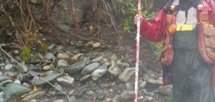
2 1.0 Introduction Phillips River is located approximately 250 km northwest of Vancouver British Columbia. Phillips River flows southwest through the Pacific Range of Coast Mountains and drains into the head of Phillips Arm. It drains an area of approximately 450 km 2 and has a length of 38.9 km. (Hatfield Consultants Ltd. 2001) (Figure 1 and Drawing Phillips 10). Phillips River supports five Pacific salmon species; Coho, Chinook, Sockeye, Chum and Pinks. Of the five species pink salmon escapements are the largest with even year runs averaging 186,400 between 1985 and 1994 (Hatfield Consultants Ltd.). The Phillips River was assessed by M. Miles and Associates Ltd. (2000) to determine what remedial actions could be taken to stop erosion problems along the left bank of the Phillips River. In 2005 M.C. Wright and Associates and representatives of DFO inspected Bend B to determine the extent of erosion since it was last measured in 2001 and to determine what works would be required to protect Bend B from further erosion. 2.0 Location The closest communities are Campbell River (70 km southwest on Vancouver Island) and Powell River (95 km south on the Sunshine Coast). The work site is adjacent to Clearwater Creek. 3.0 Objectives 1. Collect the necessary information required to develop a prescription to protect the left bank of the Phillips River at Bend B using rock groynes. The information required was longitudinal and cross-sectional profiles of the Philips River mainstem at Bend B. 2. Create engineered drawings for the construction of 17 rock groynes. 4.0 Rationale Between 1991 and 1999, >210 m of bank erosion occurred at Bend B (the site of interest for this prescription) (Miles 2000). Miles (2000) has identified that bank erosion at Bend B could impact the mainline road and Bend A if nothing is done. Silt generated as the result of bank erosion at Bank B has likely caused aggrading of spawning and rearing habitat downstream as well as reduced incubation success at downstream spawning habitat. Between 2000 and 2005 the Phillips River has continued to under go bank erosion at an average annual rate of approximately 5.8 meters. Since last measured in 2000, an additional 29 M.C. Wright and Associates Prescription Series Phillips River Groynes
3 m of bank has eroded. As of June 7, 2005, 62m of riparian forest is left between the Phillips River mainline and the Phillips River. If this situation is allowed to continue the chances of loosing the Phillips mainline logging road from erosion at Bend B is high. The continued erosion of the river bank at Bend B combined with the potential loss of the mainline logging road would severely impact the already declining wild salmon populations by destroying spawning and rearing habitat. In the Taylor River Watershed on Vancouver Island a similar situation occurred along the Taylor River Mainline logging road. At that time M.C. Wright and Associates in collaboration with the Department of Fisheries and Oceans developed a strategy to install rock groynes along the right bank of the river to alleviate or reduce the hydraulic stress at critical locations along the river bank. Installing the rock groynes reduced the hydraulic forces where bank materials were erosive improving bank stability. Monitoring has shown that erosion has been eliminated along the bend and has started to train the thelwag of the river away from the Taylor River mainline. 5.0 Assessment Works On June 7, 2005, Mike Wright, M.C. Wright and Associates and, Russ Doucet and Rick Senger from DFO conducted a field assessment of Bend B to determine how much of the remaining bank has been lost since At the time of the survey the Phillips River had eroded the left bank to within 65 meters of the Phillips River mainline logging road. On September 30 th, 2005, M.C. Wright and Associates personnel and Greg Keel of Parallel-Geo Services surveyed Bend B using RTK- GPS technology. Representative photographs of work site are presented in Plates 1 through 11. Details for the proposed works are presented in Table 1 and Drawings Phillips 10, 20 and Prescription The primary objective of the project is to construct 17 groynes to reduce the hydraulic forces along Bend B to increase bank stability and reduce sediment transport to downstream spawning and rearing habitat 6.1 Accessing the Work Site Access to the work site will be via barge for the equipment. Personnel will be moved by boat, floatplane or helicopter to the Phillips River Camp which is owned and operated by Cascadia Forest Products. From the camp, equipment and personnel can access the work site through the current network of logging roads. The access from the mainline to the work site will require upgrading old spur roads (Drawing Phillips 20). M.C. Wright and Associates Prescription Series Phillips River Groynes
4 6.2 Creating Access Old spur roads will be rehabilitated to allow equipment access to the work site. The location of the temporary road is indicated on the plan view drawings Phillips 10 and 20. Spoil from the work site will be transported to a designated spoil site to be determined in advance of commencement of the project. 6.3 Isolating the Site It is not practical to isolate the work site. As with other groyne installations an agreement with DFO to install the groynes in the wet will be required. The Taylor River groynes were installed in the wet because it was virtually impossible to isolate the work site. Silt is generated when keying any groyne into the riverbed. The operator will be required to excavate for a set period of time, stop and allow for the area to clear before resuming excavation. Water quality will be monitored to ensure sediment load is kept within acceptable limits. Turbidity levels will be set by DFO. Once the groyne is keyed in and construction is above the water line siltation is minimal. 6.4 Groyne Construction The bank stabilization plans call for the installation of 17 rock groynes spaced at 25 m intervals along the left bank of Bend B (Table 1 and Drawings Phillips 10, 20 and 30). The first groyne will be constructed at Groyne locations lengths and rock quantities are presented in Table 1. Rock to construct the groynes will be evenly graded from 600mm to 1000mm nominal diameter. Once the groynes are installed the excavator(s) will scalp the gravel bar along the right side of the channel and side cast the material against the left bank between each groyne to cover the fine textured sediments and gravels which will increase stability between the groynes. The gravels placed on the banks should be placed to a thickness of approximately 300mm. A plan view drawing and cross sections of the work site are presented in drawing Phillips 20. Groyne plan and sections are presented in Phillips Environmental measures All areas disturbed during construction will be seeded with West Coast Hemlock Mix. The seed mixture is comprised of: 5.0% Canadian Bluegrass 20.0% Alsike Clover M.C. Wright and Associates Prescription Series Phillips River Groynes
5 5.0% Azay Sheeps Fescue 30.0% Creeping Red Fescue #1 5.0% Orchard Grass 10.0% Red Top Bentgrass 15.0% Timothy 10.0% Birdsfoot Terfoil Because spawning salmon are known to enter this system as early as late August this prescription should be done during the low flow period between late July and September 1. Excavators and trucks will be in good repair and will have to be power washed prior to working at the site. A 20 m oil containment boom will have to be on-site at all times. The oil containment boom will be deployed at all times. Spill kits for the excavators will be required at all times. A supply of oil absorbent pads will also be necessary. All fuelling of equipment will be done on the logging road away from the channel. Supplies to be on-site to contain silt if necessary are; 1. 2 x 4 inch trash pumps and 600 ft of discharge hose per pump 2. tarps, rope and a roll of polyethylene 3. sandbags. 7.0 Recommendations: It should be specified in the bid package that excavator operators have experience with stream restoration. The operator s qualifications should be provided with the bid. The contractor will not be allowed to substitute operators unless approved by the site manager. Monitoring of the groynes should occur after the area has experienced a number of flood events (winter of 2007). If funding is not sufficient to complete the project in 2007 then consideration should be given to completing the project in It is critical that the first 11 groynes are built in M.C. Wright and Associates Prescription Series Phillips River Groynes
6 8.0 Costing: A breakdown of costs associated with installing the rock groynes are provided in Table References Hatfield Consultants Ltd Reconnaissance (1:20,000) Fish and Fish Habitat Inventory of Phillips River Watershed WSC: Volume 1 of 2. Prepared for Ministry of Environment, Lands and Parks Lower Mainland Region, Surrey BC. M. Miles and Associates Ltd Phillips River Mainline Bank Erosion Opposite Clearwater River. Prepared for Stillwater Timberlands, Weyerhaeuser Company Ltd. M.C. Wright and Associates Prescription Series Phillips River Groynes


7 Plate 1. This photograph shows the location of cross section 1. Plate 2. This photograph shows the location of Plate 3. This photograph shows the location of Cross section #2. Cross section #3.. Plate 4. This photograph shows the location of Cross section #4. Plate 5. Thid photograph shows the location of Plate 6. Thid photograph shows the location of Cross section # 5. Cross section # 6.


8 Plate 7. Shows the location of Cross Section #7. Plate 8. Shows one of the braids at Cross Section #7. \ Plate 9. Shows all of the braids in the Phillips River located at Cross Section #7.


9 Plate 10. This photograph shows the control station for the survey and subsequent surveys Plate 11. This photograph shows the GPS equipment used to survey the Phillips River.
10 Phillips River Bank Erosion Bend B Table 1. Rock Quantities needed to Construct 17 Groynes at Bend B in the Phillips River. m 3 m 3 m 3 Length of Groyne Number Section Quantity Key Plus 20% Groyne at the Centerline Total Amount of Rock Required Plus 20% Contingency m 3
11 Table 2. Estimated costs for the Phillips River Groyne Project at Bend B, Unit Expanded Item # Construction Item Description Qty Unit Cost Cost 1 Mob/Demob lump sum barging 2 units $ 5,000 $10, site transport pick-up trucks 2 trucks 20 day $ 200 $4, minor purchases and equipment rentals pumps, fabric, netting,culvert. 3 week $ 1,500 $4, Prep quary for blasting 1-30 ton track excavator 8 hr $ 160 $1, Rock quarry riprap development 2300 cu.m riprap at approx 10 km from site 2300 cu.m $ 12 $27, prepare access from the mainline to groyne locations 1-20 tonne and 1-30 tonne track excavators 30 hr $ 300 $9, Hauling rock to the construction site 2 rock trucks 115 hr $ 200 $23, rock structures at approx 175 cu.m 1-20 tonne and 1-30 tonne track excavators (one loading and one placing) 9 units $ 3,795 $34, rock structures at approx 90 cu.m 1-20 tonne and 1-30 tonne track excavators (one loading and one placing) 8 units $ 2,760 $22, approx 750 cu.m river rock/gravel between groynes 1-20 tonne and 1-30 tonne track excavators 50 hr $ 300 $15, approx 750 cu.m river rock/gravel between groynes trucking 45 hr $ 200 $9, river bar reshaping 1-20 tonne and 1-30 tonne track excavators 35 hr $ 300 $10, LWD complexing-procurement and installations 1-20 and 1-30 tonne track excavators and 2 trucks 30 hr $ 500 $15, site cleanup/deactivation 1-20 tonne and 1-30 tonne track excavators 25 hr $ 300 $7, room and board for 4 crew, 1 supervisor,1 other camp 20 day $ 600 $12, Supervisor Project supervisor 24 day $ 500 $12, Technician/Laborer Survey Tech/General Labour/Biological Tech. 24 day $ 350 $8, Construction subtotal: $225, Post construction 1 project report As built survey and reporting 10 day $ 400 $4, monitoring Project supervisor, technician, helicopter, equipment and report 1 day est $3, Post-construction subtotal: $7, Total (Excluding Taxes): $232,015.00

12 Source Hatfield Consultants Limited.
13
14

15
Columbia Estuary Province
 Rolling Provincial Review: Implementation 2001-2004 Province 73 Columbia Basin Fish & Wildlife Authority Province FY 2001-2004 Spending Summaries NPCC Recommendations and BPA Spending by Project Category,
Materials. Use materials meeting the following.
 208.01 Section 208. SOIL EROSION AND SEDIMENTATION CONTROL 208.01 Description. Install and maintain erosion and sedimentation controls to minimize soil erosion and to control sedimentation from affecting
APPENDIX E. GEOMORPHOLOGICAL MONTORING REPORT Prepared by Steve Vrooman, Keystone Restoration Ecology September 2013
 APPENDIX E GEOMORPHOLOGICAL MONTORING REPORT Prepared by Steve Vrooman, Keystone Restoration Ecology September 2 Introduction Keystone Restoration Ecology (KRE) conducted geomorphological monitoring in
Use of Bioengineering Techniques for Revegetation of Riparian Areas: Colomac Mine Remediation Project, NWT
 Use of Bioengineering Techniques for Revegetation of Riparian Areas: Colomac Mine Remediation Project, NWT McPherson, M. 1, Vanderspiegel, R. 2, Breadmore, R. 2, and Hewitt, M. 3 2012 RPIC Federal Contaminated
1.0 INSPECTION ANNUAL INSPECTION, JUNE 29, 2011 CARMACKS COPPER PROJECT, CARMACKS, YUKON. Dear Mr. West-Sells,
 Doc. No. 162 Rev. 0 Mr. Paul West-Sells President & Chief Operating Officer Western Copper Corporation 2060-1111 West Georgia Street Vancouver, BC V6E 4M3 ANNUAL INSPECTION, JUNE 29, 2011 CARMACKS COPPER
Lower South Fork McKenzie River Floodplain Enhancement Project
 Lower South Fork McKenzie River Floodplain Enhancement Project McKenzie River Ranger District Willamette National Forest Project Location The project is located in the South Fork McKenzie River Watershed,
-- Lessons from a successful salmon stream and estuary relocation on Gravina Island
 Re-inventing Government Creek -- Lessons from a successful salmon stream and estuary relocation on Gravina Island Jon Houghton, Ph.D. and Derek Ormerod, M.S., P.E. - Pentec Environmental/Hart Crowser,
Tom Blackman Project Lead. Mékell Mikell Communications Representative
 Sediment Cleanup Middle River Complex, 2016-17 Season 1 Project Photo Tour Updated November 15, 2016 Tom Blackman Project Lead Mékell Mikell Communications Representative 1 Sediment Cleanup - Season 1
Integrating flood mitigation, sediment management and habitat enhancement on coastal rivers of British Columbia
 River Basin Management VII 301 Integrating flood mitigation, sediment management and habitat enhancement on coastal rivers of British Columbia D. McLean 1, V. Galay 1, B. Wright 2 & W. Fleenor 3 1 Northwest
Stop 1: Marmot Dam Stop 1: Marmot Dam
 Stop 1: Marmot Dam Stop 1: Marmot Dam Following the removal of Marmot Dam in 2007, the fate of the reservoir sediments has been monitored through a series of surveys and sediment transport measurements.
Island 32 Erosion. prepared for Ministry of Environment, Lands and Parks A Street Surrey, British Columbia, V3R 7P8. and
 Island 32 Erosion prepared for Ministry of Environment, Lands and Parks 10334 152A Street Surrey, British Columbia, V3R 7P8 and District of Chilliwack 8550 Young Road Chilliwack, British Columbia, V2P
Subcommittee on Sedimentation Draft Sediment Analysis Guidelines for Dam Removal
 Subcommittee on Sedimentation Draft Sediment Analysis Guidelines for Dam Removal August 4, 2011 Jennifer Bountry, M.S., P.E. Tim Randle, M.S., P.E., D.WRE. Blair Greimann, Ph.D., P.E. Sedimentation and
Fluvial Driven Alluvial Fans
 Fluvial Driven Alluvial Fans Restoration Project Evaluations - Examples from the Russian and Napa River Watersheds Mia Docto Masters Thesis UC Berkeley 1. Basic Fan Description 2. Fluvial Driven Fan Characteristics
Case Study 2: Twenty-mile Creek Rock Fords
 Case Study : Twenty-mile Creek Rock Fords Location Crossing Description Washington. Okanagan National Forest. Methow Valley Ranger District. Chewuch river basin, East Chewuch Road. The Twenty-mile Creek
Carmel River Bank Stabilization at Rancho San Carlos Road Project Description and Work Plan March 2018
 Carmel River Bank Stabilization at Rancho San Carlos Road Project Description and Work Plan March 2018 EXISTING CONDITION The proposed Carmel River Bank Stabilization at Rancho San Carlos Road Project
Field Observations and One-Dimensional Flow Modeling of Summit Creek in Mack Park, Smithfield, Utah
 Intermountain Center for River Rehabilitation and Restoration, Utah State University 31 July 2018 Field Observations and One-Dimensional Flow Modeling of Summit Creek in Mack Park, Smithfield, Utah I.
Orica Australia Pty Ltd Ammonium Nitrate Facility Upgrade
 Orica Australia Pty Ltd Ammonium Nitrate Facility Upgrade January 2010 Revision 0 Contents 1. Introduction 1 1.1 Purpose 1 1.2 Objectives 1 1.3 Relevant Environmental Legislation, Guidelines and Policies
ISSUED FOR CONSTRUCTION
 PAGE No. DESCRIPTION 1 Cover Page 2 Overview Map 3 Western Road Plan View 4 Eastern Road Plan View West Road Profiles & Cross Sections 6-7 East Road Profiles 8- East Road Cross Sections 11-14 Campsite
OC Public Works El Niño Storm Preparation 2015
 OC Public Works El Niño Storm Preparation 2015 December 8, 2015 Overview About OC Public Works Storm Preparation Pre-Storm During Storm Post-Storm Storm Preparation Canyon and Burn Areas County Department
December 11, 2006 File:
 December 11, 2006 File: 15-85-38 Alberta Infrastructure and Transportation Room 301, Provincial Building 9621-96 Avenue Peace River, Alberta T8S 1T4 Attention: Mr. Ed Szmata PEACE REGION (SWAN HILLS AREA)
U-Shaped Sediment Traps
 U-Shaped Sediment Traps SEDIMENT CONTROL TECHNIQUE Type 1 System Sheet Flow Sandy Soils Type 2 System Concentrated Flow Clayey Soils [1] Type 3 System Supplementary Trap Dispersive Soils [1] Generally
Black Gore Creek 2013 Sediment Source Monitoring and TMDL Sediment Budget
 Black Gore Creek 2013 Sediment Source Monitoring and TMDL Sediment Budget Prepared for: Prepared By: - I. Introduction The Black Gore Creek Total Maximum Daily Load (TMDL) was developed in collaboration
Stream Simulation: A Simple Example
 Stream Simulation: A Simple Example North Thompson Creek, CO Paul T. Anderson U.S.D.A. Forest Service Here s How We Started May 2011 2-1 USDA-Forest Service Here s How We Finished Forest Service Aquatic
Project (Project No. US-CA-62-2) Maintenance Inspection and Reports (Subtask 14.1) Inspection Report No.2
 Maintenance Inspection and Reports (Subtask 14.1) Inspection Report No.2") MEMORANDUM TO: FROM: Jim Well, Ducks Unlimited Mike Harvey, PhD, PG SUBJECT: M&T/ Llano Seco Fish Screen Project (Project No. US-CA-62-2) Maintenance Inspection and Reports (Subtask 14.1) Inspection Report
MEMORANDUM TO: FROM: Jim Well, Ducks Unlimited Mike Harvey, PhD, PG SUBJECT: M&T/ Llano Seco Fish Screen Project (Project No. US-CA-62-2) Maintenance Inspection and Reports (Subtask 14.1) Inspection Report
The Effects of Geomorphology and Watershed Land Use on Spawning Habitat
 The Effects of Geomorphology and Watershed Land Use on Spawning Habitat By Evan Buckland INTRODUCTION The distribution and frequency of large geomorphic features in a watershed govern where suitable spawning
HAW CREEK, PIKE COUNTY, MISSOURI-TRIB TO SALT RIVER ERODING STREAM THREATHENING COUNTY ROAD #107, FOURTEEN FT TALL ERODING BANK WITHIN 4 FT OF THE
 HAW CREEK, PIKE COUNTY, MISSOURI-TRIB TO SALT RIVER ERODING STREAM THREATHENING COUNTY ROAD #107, FOURTEEN FT TALL ERODING BANK WITHIN 4 FT OF THE ROAD, PROJECT CONSTRUCTED IN 1 DAY, MARCH 10, 2009 BY
In-channel coarse sediment trap Best Management Practice
 In-channel coarse sediment trap Best Management Practice By Henry R. Hudson July 2002 Environmental Management Associates Ltd., Christchurch Complexity Environmental Value Cost Low Moderate High Low Moderate
B805 TEMPORARY EROSION AND SEDIMENT CONTROL MEASURES - OPSS 805
 B805 MEASURES - OPSS 805 805.1 GENERAL Construction activities frequently remove protective cover and expose soil to accelerated rates of erosion. Sediments generated thereby can be conveyed via runoff
ASSESSMENT REPORT ON THE PEAVINE PROJECT. DGW & Associates # Alberni Street, Vancouver, British Columbia, V6E 4V2
 ASSESSMENT REPORT ON THE PEAVINE PROJECT KAMLOOPS MINING DIVISION BRITISH COLUMBIA NTS 082M 12 Latitude 51 36' 19.0"North -- Longitude --119 47' 27.0"West UTM Zone 11, NAD 83 5720827N 306744E Prepared
Squaw Creek. General Information
 General Information is a tributary to the Salmon River. It enters the north side of the river about 0 miles downstream of North Fork, Idaho. The study reach is about a 30 ft length of stream about 2 miles
Coarse Sediment Traps
 Coarse Sediment Traps SEDIMENT CONTROL TECHNIQUE Type 1 System Sheet Flow Sandy Soils Type 2 System [1] Concentrated Flow Clayey Soils [2] Type 3 System Supplementary Trap Dispersive Soils [1] Though primarily
Stream Geomorphology. Leslie A. Morrissey UVM July 25, 2012
 Stream Geomorphology Leslie A. Morrissey UVM July 25, 2012 What Functions do Healthy Streams Provide? Flood mitigation Water supply Water quality Sediment storage and transport Habitat Recreation Transportation
6.11 Naas River Management Unit
 6.11 Naas River Management Unit 6.11.1 Site 41 Issue: Bed and bank erosion Location: E 0685848 N 6058358 Waterway: Naas River Management Unit: Naas River Facing downstream from Bobeyan Rd bridge Facing
RAILWAYS AND FISH: HOW TO PROTECT AND ENHANCE FISH HABITAT VALUES AT STREAM CROSSINGS THROUGH PROJECT DESIGN AND CONSTRUCTION
 RAILWAYS AND FISH: HOW TO PROTECT AND ENHANCE FISH HABITAT VALUES AT STREAM CROSSINGS THROUGH PROJECT DESIGN AND CONSTRUCTION Rail Environment Conference November 2016 AGENDA Objective Background Benefits
White River Update. Jeanne Stypula, Supervising Engineer. Advisory Committee Meeting April 26, 2016
 White River Update Jeanne Stypula, Supervising Engineer Advisory Committee Meeting April 26, 2016 Department of Natural Resources and Parks Water and Land Resources Division River and Floodplain Management
Important Copyright Information
 Important Copyright Information The following content is provided for educational purposes by the workshop presenter. This content may or may not have been peer reviewed. Information, opinions and recommendations
San Joaquin River Tributary Sediment Transport and Geomorphology Study
 Study 22 San Joaquin River Tributary Sediment Transport and Geomorphology Study Public Draft 2013 Monitoring and Analysis Plan September 2012 22.0 San Joaquin River Tributary Sediment Transport and Geomorphology
ADDRESSING GEOMORPHIC AND HYDRAULIC CONTROLS IN OFF-CHANNEL HABITAT DESIGN
 ADDRESSING GEOMORPHIC AND HYDRAULIC CONTROLS IN OFF-CHANNEL HABITAT DESIGN Conor Shea - Hydrologist U.S. Fish and Wildlife Service Conservation Partnerships Program Arcata, CA Learning Objectives Examine
FUTURE MEANDER BEND MIGRATION AND FLOODPLAIN DEVELOPMENT PATTERNS NEAR RIVER MILES 200 TO 191 OF THE SACRAMENTO RIVER PHASE III REPORT
 FUTURE MEANDER BEND MIGRATION AND FLOODPLAIN DEVELOPMENT PATTERNS NEAR RIVER MILES 200 TO 191 OF THE SACRAMENTO RIVER PHASE III REPORT Eric W. Larsen REPORT FOR DUCKS UNLIMITED March 31, 2006-1 - Contents
Bipole III Transmission Project Construction Environmental Protection Plan Construction Section N1 Environmentally Sensitive Site Locations Map 25
 ± DOCUMENT PATH: G :\_GIS_PROJECT_FOLDER\00_HYDRO\111440054_BPIII_EPP\ARCMAP\ESS_N1\BPIII_CENVPP_N1N2N3N4C1SECTIONBASEMAP_MAPBOOK_BTB_STANTEC_20131207.MXD N1-S11 Tower 10 E-723206, N-6272609 N1-Soils-154
Schedule C By-Law Snow and Ice Control Services - Project Specifications for Various Parking Lots
 SNOW AND ICE CONTROL SERVICES - (4) SEPARATE DEPARTMENTS SCHEDULE C REQUEST FOR PROPOSAL 2244 Schedule C By-Law Snow and Ice Control Services - Project Specifications for Various Parking Lots 1.0 General
West Branch of the St. Mary s River Restoration Project 2017 Post Construction Report
 West Branch of the St. Mary s River Restoration Project 2017 Post Construction Report Department of Fisheries and Oceans Small Craft Harbours Branch August, 2017 Charles MacInnis, B.Sc. MacInnis Natural
Channel Assessments of Selected Watersheds within TFL 52
 Channel Assessments of Selected Watersheds within TFL 52 prepared for: West Fraser Mills Ltd. Quesnel, BC prepared by: John Berry, M.Sc., R.P.F. Victoria, BC Channel Assessments TFL 52 Summary SUMMARY
Specifications Whitcomb Elementary School Demolition January 15, 2016
 SECTION 31 2500 - EROSION CONTROL PART 1 - GENERAL 1.1 RELATED DOCUMENTS: A. The provisions of the Contract Documents apply to the work of this Section. B. The Virginia Erosion and Sediment Control Handbook,
EAGLES NEST AND PIASA ISLANDS
 EAGLES NEST AND PIASA ISLANDS HABITAT REHABILITATION AND ENHANCEMENT PROJECT MADISON AND JERSEY COUNTIES, ILLINOIS ENVIRONMENTAL MANAGEMENT PROGRAM ST. LOUIS DISTRICT FACT SHEET I. LOCATION The proposed
ADDENDA #1 CONTRACT # C May 3, 2013 Page 1 of 1
 State of California Natural Resources Agency Edmund G. Brown Jr., Governor DEPARTMENT OF PARKS AND RECREATION Major General Anthony L. Jackson, USMC (Ret), Director ADDENDA #1 CONTRACT # C1247040 May 3,
East Branch Grand Calumet River Great Lakes Legacy Act Sediment Remediation and Restoration Project
 East Branch Grand Calumet River Great Lakes Legacy Act Sediment Remediation and Restoration Project Jointly funded by the U.S. EPA Great Lakes Legacy Act, Indiana Department of Environmental Management
CR AAO Bridge. Dead River Flood & Natural Channel Design. Mitch Koetje Water Resources Division UP District
 CR AAO Bridge Dead River Flood & Natural Channel Design Mitch Koetje Water Resources Division UP District Old County Road AAO Bridge Map courtesy of Marquette County Silver Lake Basin McClure Basin
MISSION CREEK WATERSHED (2002 Report Year 4)
") Stream Channel Monitoring Program for the MISSION CREEK WATERSHED (2002 Report Year 4) (Penticton Forest District) Prepared for RIVERSIDE FOREST PRODUCTS LTD. Prepared by DOBSON ENGINEERING LTD. #4, 1960
Stream Channel Monitoring Program for the MISSION CREEK WATERSHED (2002 Report Year 4) (Penticton Forest District) Prepared for RIVERSIDE FOREST PRODUCTS LTD. Prepared by DOBSON ENGINEERING LTD. #4, 1960
Swift Creek Sediment Management Action Plan (SCSMAP)
") Swift Creek Sediment Management Action Plan (SCSMAP) PHASE 2 PROJECT PLAN PROPOSAL Whatcom County Public Works Department 322 N. Commercial Street, Suite 210 Bellingham, WA 98225 (360) 676-6692 June 2013
Swift Creek Sediment Management Action Plan (SCSMAP) PHASE 2 PROJECT PLAN PROPOSAL Whatcom County Public Works Department 322 N. Commercial Street, Suite 210 Bellingham, WA 98225 (360) 676-6692 June 2013
Bank Erosion and Morphology of the Kaskaskia River
 Bank Erosion and Morphology of the Kaskaskia River US Army Corps Of Engineers St. Louis District Fayette County Soil and Water Conservation District Team Partners : Carlyle Lake Ecosystem Partnership Vicinity
SEARCHING FOR SEDIMENT SOURCES IN SPRING CREEK
 SEARCHING FOR SEDIMENT SOURCES IN SPRING CREEK Christopher Frederick, Department of Earth Sciences, University of South Alabama, Mobile, AL 36688. E-mail: cjf702@jaguar1.usouthal.edu. Sediment deposition
R.M.HARW & ASSOCIATES LTD. GEOTECHNICAL INVESTIGATION PROPOSED BRIDGE SITE. HELAVA CREEKl MILE MACKENZIE HIGHWAY E-2510 OCTOBER 16, 1973
 El R.M.HARW & ASSOCIATES LTD. GEOTECHNICAL INVESTIGATION PROPOSED BRIDGE SITE HELAVA CREEKl MILE 616.4 MACKENZIE HIGHWAY E-2510 OCTOBER 16, 1973 R,M,HARDV & ASSOCIATES LTD. CONSULTING ENGINEERING & TESTING
Diagnostic Geomorphic Methods for Understanding Future Behavior of Lake Superior Streams What Have We Learned in Two Decades?
 Diagnostic Geomorphic Methods for Understanding Future Behavior of Lake Superior Streams What Have We Learned in Two Decades? Faith Fitzpatrick USGS WI Water Science Center, Middleton, WI fafitzpa@usgs.gov
Stone Outlet Sediment Trap
 3.12 Sediment Control Description: A stone outlet sediment trap is a small detention area formed by placing a stone embankment with an integral stone filter outlet across a drainage swale for the purpose
Upper Mississippi River Basin Environmental Management Program Workshop
 Presentation to the Upper Mississippi River Basin Environmental Management Program Workshop by Michael Rodgers River Engineer US Army Corps of Engineers, St. Louis District August 17, 2007 Engineering
Solutions to Flooding on Pescadero Creek Road
 Hydrology Hydraulics Geomorphology Design Field Services Photo courtesy Half Moon Bay Review Solutions to Flooding on Pescadero Creek Road Prepared for: San Mateo County Resource Conservation District
DETAILED DESCRIPTION OF STREAM CONDITIONS AND HABITAT TYPES IN REACH 4, REACH 5 AND REACH 6.
 DETAILED DESCRIPTION OF STREAM CONDITIONS AND HABITAT TYPES IN REACH 4, REACH 5 AND REACH 6. The Eklutna River was divided into study reaches (figure 1) prior to this site visit. Prominent geologic or
Opportunities to Improve Ecological Functions of Floodplains and Reduce Flood Risk along Major Rivers in the Puget Sound Basin
 Opportunities to Improve Ecological Functions of Floodplains and Reduce Flood Risk along Major Rivers in the Puget Sound Basin Christopher Konrad, US Geological Survey Tim Beechie, NOAA Fisheries Managing
J-river engineering for Vietnam
 J-river engineering for Vietnam Workshop on erosion control in the Mekong Delta Soc Trang, June 2015 Onga river, Japan Dr. MATSUKI Trung: JICA Expert 1 Project for Building Disaster Resilient Society in
REPORT OF PHYSICAL EXPLORATION AND DEVELOPMENT Section 15 - Mineral Tenure Act Regulation
 1. EVENT NUMBER(S) 1234567 4. RECORDED HOLDER Doe 123 Main Street REPORT OF PHYSICAL EXPLORATION AND DEVELOPMENT Section 15 - Mineral Tenure Act Regulation Mineral Titles and Policy Branch Ministry of
M. Sloat, AAg., CPESC R.J. Redden, R.P.Bio., A.Sc.T., CPESC. EDI Environmental Dynamics Inc Continental Way Prince George, B.C.
 OVERVIEW OF BEST PRACTICES FOR SURFACE EROSION PROTECTION AND SEDIMENT CONTROL FOR THE DEVELOPMENT PHASE OF SURFACE MINING FOR COAL IN NORTHEAST BRITISH COLUMBIA M. Sloat, AAg., CPESC R.J. Redden, R.P.Bio.,
NATURAL RIVER. Karima Attia Nile Research Institute
 NATURAL RIVER CHARACTERISTICS Karima Attia Nile Research Institute NATURAL RIVER DEFINITION NATURAL RIVER DEFINITION Is natural stream of water that flows in channels with ih more or less defined banks.
¾À 280. ESS Features Heritage. Points of Access* !( Proposed Access Point. !( Archaeological Water. Major Stream Crossing Abandoned Rail Crossing # #
 ± DOCUMENT PATH: G :\_GIS_PROJECT_FOLDER\00_HYDRO\111440054_BPIII_EPP\ARCMAP\ESS_N1\BPIII_CENVPP_N1N2N3N4C1SECTIONBASEMAP_MAPBOOK_BTB_STANTEC_20131207.MXD 386 N1-S30 385 BURNTWOOD RIVER Coordinate System:
Evaluation of Geomorphic Effects of Removal of Marmot and Little Sandy Dams and Potential Impacts on Anadromous Salmonids
 PRELIMINARY FINAL Evaluation of Geomorphic Effects of Removal of Marmot and Little Sandy Dams and Potential Impacts on Anadromous Salmonids Prepared for: Portland General Electric 121 SW Salmon Street
CASE STUDIES. Introduction
 Introduction The City of Winston-Salem faces the challenge of maintaining public infrastructure (e.g., water and sewer lines, storm drains, roads, culverts and bridges) while minimizing the potential impacts
THE MINISTRY OF ENERGY AND ENERGY INDUSTRIES MINERALS DIVISION MINE DESIGN TEMPLATE OPERATOR NAME: OPERATOR ADDRESS: PHONE NUMBER: FACSIMILE:
 THE MINISTRY OF ENERGY AND ENERGY INDUSTRIES MINERALS DIVISION MINE DESIGN TEMPLATE 1.0 GENERAL INFORMATION OPERATOR NAME: OPERATOR ADDRESS: PHONE NUMBER: FACSIMILE: NAME OF CONTACT: CELLULAR PHONE: EMAIL
Natural Variability in Annual Maximum Water Level and Outflow of Yellowstone Lake
 Natural Variability in Annual Maximum Water Level and Outflow of Yellowstone Lake Phillip E. Farnes Abstract The water level in Yellowstone Lake varies each year in response to differences in the winter
Agenda. INDOT Office of Environmental Services. Describe Results of FHWA QAR. Landscape and Waterway Permitting Unit. Interviews Site Inspections
 Nathan Saxe Administrator, Ecology and Waterway Permitting Section Back to Basics: Erosion and Sediment Control FHWA INDOT Quality Assurance Review (QAR) Results 1 Agenda INDOT Office of Environmental
GEOMORPHIC CHANGES IN LOWER CACHE CREEK 2012
 GEOMORPHIC CHANGES IN LOWER CACHE CREEK 2012 Eric W. Larsen Technical Memorandum Prepared for Cache Creek Technical Advisory Committee Natural Resources Program Yolo County Board of Supervisors 2012 Prepared
Waterbury Dam Disturbance Mike Fitzgerald Devin Rowland
 Waterbury Dam Disturbance Mike Fitzgerald Devin Rowland Abstract The Waterbury Dam was completed in October 1938 as a method of flood control in the Winooski Valley. The construction began in April1935
t+o...&zz!. ASSESSMENT REPORT Department of Miner and Petroleum Resources MAP.,- INDUCED POLAKIZATION SURVEY OVER THE BROOKS PROSPECT
 5873 INDUCED POLAKIZATION SURVEY OVER THE BROOKS PROSPECT BROOKS PENINSULA AREA VANCOUVER ISLAND, B.C. NANAIMO AND ALBERNI MINING DIVISIONS BY Z. B. DOBORZYNSKI JANUARY, 1976 Department of Miner and Petroleum
ES 105 Surface Processes I. Hydrologic cycle A. Distribution % in oceans 2. >3% surface water a. +99% surface water in glaciers b.
 ES 105 Surface Processes I. Hydrologic cycle A. Distribution 1. +97% in oceans 2. >3% surface water a. +99% surface water in glaciers b. >1/3% liquid, fresh water in streams and lakes~1/10,000 of water
Long Valley Meadow Restoration Project
 Long Valley Meadow Restoration Project USDA Forest Service Mogollon Rim Ranger District Coconino National Forest Coconino County, Arizona T13N, R9E, Section 12 and T13N, R10E, Sections 6 and 7 Gila and
David Moore, PacifiCorp Cultural Resources Coordinator Denise DeJoseph, Project Archaeologist
 References DeJoseph, Denise 2011 Lewis River HPMP: Swift Camp FSC Survey Negative Results. Memo report submitted by Historical Research Associates to PacifiCorp, Portland, Oregon. Copies available at PacifiCorp,
Rock & Aggregate Drop Inlet Protection
 Rock & Aggregate Drop Inlet Protection SEDIMENT CONTROL TECHNIQUE Type 1 System Sheet Flow Sandy Soils Type 2 System [1] Concentrated Flow Clayey Soils Type 3 System Supplementary Trap Dispersive Soils
ODFW AQUATIC INVENTORY PROJECT RESTORATION MONITORING STREAM HABITAT REPORT. Peggy Kavanagh, Trevan Cornwell TOLEDO SOUTH Coast Range Lora Tennant
 ODFW AQUATIC INVENTORY PROJECT RESTORATION MONITORING STREAM HABITAT REPORT STREAM: GCG: 2-MC SITE ID: 489 BASIN: YAQUINA TREATMENT DATE: 24 SURVEY DATE: 2/27/24 SURVEY CREW: USGS MAPS: ECOREGION: REPORT
Ecosystem response during the removal of the Elwha River Dams
 Ecosystem response during the removal of the Elwha River Dams Presentation Prepared by George Pess - NOAA Photo by John McMillan December 2015 Elwha The Elwha River Basin Olympic Natl. Park > 90% of habitat
Hydraulics of bendway weirs
 River Basin Management IV 389 Hydraulics of bendway weirs C. Thornton 1, S. Abt 1, D. Baird 2 & R. Padilla 3 1 Colorado State University, Fort Collins, CO, USA 2 U.S. Bureau of Reclamation, Denver, CO,
Restoring the Napa River:
 Restoring the Napa River: lessons learned from a long term private-public project Andy Collison Environmental Science Associates acollison@esassoc.com 1 Napa River Restoration Projects Rutherford Reach
Matsqui Bend Erosion
 Matsqui Bend Erosion prepared for Ministry of Environment, Lands and Parks 10334 152A Street Surrey, British Columbia, V3R 7P8 by Hamish Weatherly, Michael Church, and Darren Ham Department of Geography
Spring Run Spawning Habitat Assessment Sediment Mobility
 Study 47 Spring Run Spawning Habitat Assessment Sediment Mobility Final 2015 Monitoring and Analysis Plan January 2015 1.0 Spring Run Spawning Habitat Assessment Sediment Mobility Theme(s): Flow management
WELCOME Lake Wabukayne OPEN HOUSE
 WELCOME Lake Wabukayne Sediment Removal Project OPEN HOUSE We are here to: Update you, the community, on recent developments and activities at Lake Wabukayne Present the preferred alternative and receive
June 9, R. D. Cook, P.Eng. Soils Engineer Special Services Western Region PUBLIC WORKS CANADA WESTERN REGION REPORT ON
 PUBLIC WORKS CANADA WESTERN REGION REPORT ON GEOTECHNICAL INVESTIGATION PROPOSED MARTIN RIVER BRIDGE MILE 306.7 MACKENZIE HIGHWAY Submitted by : R. D. Cook, P.Eng. Soils Engineer Special Services Western
Aquifer an underground zone or layer of sand, gravel, or porous rock that is saturated with water.
 Aggradation raising of the streambed by deposition that occurs when the energy of the water flowing through a stream reach is insufficient to transport sediment conveyed from upstream. Alluvium a general
Husky Oil Operations Limited
 Husky Oil Operations Limited 707 8th Avenue S.W. Bus: (403) 298-6111 Box 6525, Station D Fax: (403) 298-6378 Calgary, Alberta, Canada T2P 3G7 October 31, 2014 Sahtu Land &Water Board SLWB File: S13L1-005
HISTORY OF CONSTRUCTION FOR EXISTING CCR SURFACE IMPOUNDMENT PLANT GASTON ASH POND 40 CFR (c)(1)(i) (xii)
(1)(i) (xii)") HISTORY OF CONSTRUCTION FOR EXISTING CCR SURFACE IMPOUNDMENT PLANT GASTON ASH POND 40 CFR 257.73(c)(1)(i) (xii) (i) Site Name and Ownership Information: Site Name: E.C. Gaston Steam Plant Site Location:
HISTORY OF CONSTRUCTION FOR EXISTING CCR SURFACE IMPOUNDMENT PLANT GASTON ASH POND 40 CFR 257.73(c)(1)(i) (xii) (i) Site Name and Ownership Information: Site Name: E.C. Gaston Steam Plant Site Location:
Bipole III Transmission Project Construction Environmental Protection Plan Construction Section N2 Environmentally Sensitive Site Locations Map 81
 ± DOCUMENT PATH: G :\_GIS_PROJECT_FOLDER\00_HYDRO\111440054_BPIII_EPP\ARCMAP\ESS_N2\BPIII_CENVPP_N1N2N3N4C1SECTIONBASEMAP_MAPBOOK_BTB_STANTEC_20131201.MXD 196 Coordinate System: UTM Zone NAD83 Data Source:
2016 Marine Survival Forecast of Southern British Columbia Coho
 2016 Marine Survival Forecast of Southern British Columbia Coho 2016 MARINE SURVIVAL FORECAST OF SOUTHERN BRITISH COLUMBIA COHO Figure 1: Coho salmon at three life stages: freshwater rearing fry; ocean
Controlling Processes That Change Land
 1 Name Date Controlling Processes That Change Land People try to control some of the processes that change land. To do this, people apply technology- the use of science to solve problems in everyday life.
FOR PROJECTS INITIATED AFTER NOVEMBER 1, 2008 ITEM 716 EMBANKMENT EARTH OUTLET SEDIMENT TRAP
 AFTER NOVEMBER 1, 2008 ITEM 716 EMBANKMENT EARTH OUTLET SEDIMENT TRAP 716.1 Description. This work shall consist of furnishing, installing, maintaining, and removing temporary erosion protection and sediment
We are interconnected, we are resilient As air temperatures warm forests change, fires increase glaciers retreat, snowpack diminishes sediment
 We are interconnected, we are resilient As air temperatures warm forests change, fires increase glaciers retreat, snowpack diminishes sediment increases rivers change, salmon respond base sea level rises
Steven Noble MDEQ - WRD Enbridge Response Unit
 EPA situation report, October 19, 2012 Steven Noble MDEQ - WRD Enbridge Response Unit Brief history of the spill Monitoring Monitoring the impacts Follow the oil The Current Situation A Look at the Future
Geomorphology Geology 450/750 Spring Fluvial Processes Project Analysis of Redwood Creek Field Data Due Wednesday, May 26
 Geomorphology Geology 450/750 Spring 2004 Fluvial Processes Project Analysis of Redwood Creek Field Data Due Wednesday, May 26 This exercise is intended to give you experience using field data you collected
[1] Performance of the sediment trap depends on the type of outlet structure and the settling pond surface area.
![[1] Performance of the sediment trap depends on the type of outlet structure and the settling pond surface area.](/thumbs/76/74245181.jpg "[1] Performance of the sediment trap depends on the type of outlet structure and the settling pond surface area.") Sediment Trench SEDIMENT CONTROL TECHNIQUE Type 1 System Sheet Flow Sandy Soils Type 2 System [1] Concentrated Flow Clayey Soils Type 3 System [1] Supplementary Trap Dispersive Soils [1] Performance of
Sediment Trench SEDIMENT CONTROL TECHNIQUE Type 1 System Sheet Flow Sandy Soils Type 2 System [1] Concentrated Flow Clayey Soils Type 3 System [1] Supplementary Trap Dispersive Soils [1] Performance of
Surface Water Short Study Guide
 Name: Class: Date: Surface Water Short Study Guide Multiple Choice Identify the letter of the choice that best completes the statement or answers the question. 1. The three ways in which a stream carries
Monitoring of suspended sediment concentration in discharge from regulated lakes in glacial deposits
 Erosion and Sediment Transport Monitoring Programmes in River Basins (Proceedings of the Oslo Symposium, August 1992). IAHS Publ. no. 210, 1992. 269 Monitoring of suspended sediment concentration in discharge
October 26, Ms. Aimee Zack Canadian Pacific 120 S. Sixth Street Suite 900 Minneapolis, Minnesota 55402
 October 26, 2017 Ms. Aimee Zack Canadian Pacific 120 S. Sixth Street Suite 900 Minneapolis, Minnesota 55402 Re: Soo Line Dump Site 2017 Annual Soil Cover Inspection Dear Aimee: The purpose of this letter
PEACOCK D H LIMITED TAPUAEROA RIVER MEAN BED LEVEL TRENDS; 1958 TO 2016.
 PEACOCK D H LIMITED GST Reg No 97918708 email: dave2mar@gmail.com Mob: 021 02465899. Introduction: TAPUAEROA RIVER MEAN BED LEVEL TRENDS; 1958 TO 2016. This is one of a series of reports on river bed level
Island Design. UMRS EMP Regional Workshop. Presentation for the
 Island Design Presentation for the UMRS EMP Regional Workshop by Jon Hendrickson Hydraulic Engineer Regional Technical Specialist, Water Quality and Habitat Restoration August 17 19, 2005 Project Delivery