The leading geophysical company in the Baltic states
|
|
|
- Alexander Parsons
- 5 years ago
- Views:
Transcription


1 The leading geophysical company in the Baltic states
2 About Geobaltic is a young and progressive company engaged in geophysical surveys, data processing and interpretation, providing itsservices to science and industry segments. Geobaltic was founded in 2004 as a geoscience consulting company with the main focus on seismic data processing and interpretation projects. Since 2007 Geobaltic provides near-surface geophysical surveys using GPR (ground penetrating radar) and an electrical resistivity imaging system Since 2010 Geobaltic has provided 2D/3D onshore seismic acquisition and welllogging services


3 About Geobaltic is among the first seismic companies adopting green seismic standards and using new generation autonomous seismic recorders in field operations. Seismic data acquisition is carried out by making minimal environmental damage. We have unique experience in seismic acquisition under various land conditions including swamps, dense forests and transition zones. Portable mini-rigs for dynamite explosions in shotholes are used in a wetland areas and forests. This gives an opportunity to run seismic surveys without soil damage, while preserving ecological systems. 2D/3D seismic surveys are performed applying express processing and interpretation in the field. This enables clients to make quick decisions regarding adjustments of the project to get the best geological results. The company s activities are inseparable from high-tech applications, therefore the company has close links with academic institutions. The company employs a large number of highly skilled professionals with PhD and MSc degrees.

 surveys - Resistivity Imaging surveys -")
4 Services Geophysical services for Oil/Gas exploration: - 2D/3D land and transition zone seismic acquisition - Well-logging - Seismic data processing and interpretation Near-surface geophysics for engineeringgeological/archaeological purposes: - GPR (Ground Penetrating Radar) surveys - Resistivity Imaging surveys - Geodetic surveys
 marsh: geophones GS-One in marsh case (OYO Geospace) strings: 6 geophones GS-32 CT string (OYO Geospace) Sources land:")

5 Wireless 2D/3D Land Seismic Surveys Seismic recording Unite autonomous seismic recorders (Sercel) GSR autonomous seismic recorders (Oyo Geospace) Geophones land: geophones GS-One in land case (OYO Geospace) marsh: geophones GS-One in marsh case (OYO Geospace) strings: 6 geophones GS-32 CT string (OYO Geospace) Sources land: accelerated weight drop (United Service Alliance) forests & marshes: dynamite explosions in the shot holes Drilling land: drilling rig Geotech on Iveco turbo daily 4x4 platform forests & marshes: portable mini-rigs Little Beaver MDL-5H Surveying GPS stations: Topcon Hiper SR, Trimble S6 Trimble S3 Communication radios: Motorolla 2000
 Seismic Data")
 Amplitude Kul1")


6 2D/3D Seismic Data Processing and Interpretation Field data management GeoReaper & GeoMerge (Oyo Geospace) Seismic Data Interpretation GeoGraphix Discovery (Landmark Graphics) Seismic Data Processing Promax 2D/3D (Landmark Graphics) Amplitude Kul1 1-m kl m kl m A 2-m tv m kl m m m06242-m m m m0630 V-P0412_migrated 2-m0628 V-f m412 2-m m0631 CMP Shot 0 C S P2zl 300 D3st 400 D3sv D2nr D1km D1gr S2dn S2br S1ln1 C2dm PR3r


 Mini")


")


7 Well logging Data recording Micrologger 2 with USB interface Winches (Robertson Geologging) Mini winch: 175 m 3/16 inch cable capacity 3000m winch: 3000 m 3/16 inch cable capacity Probes (Robertson Geologging) Natural Gamma SP Electric log Temperature Focussed Electric (Guard) Log Deviation log Three-Arm Caliper Full-Waveform Sonic


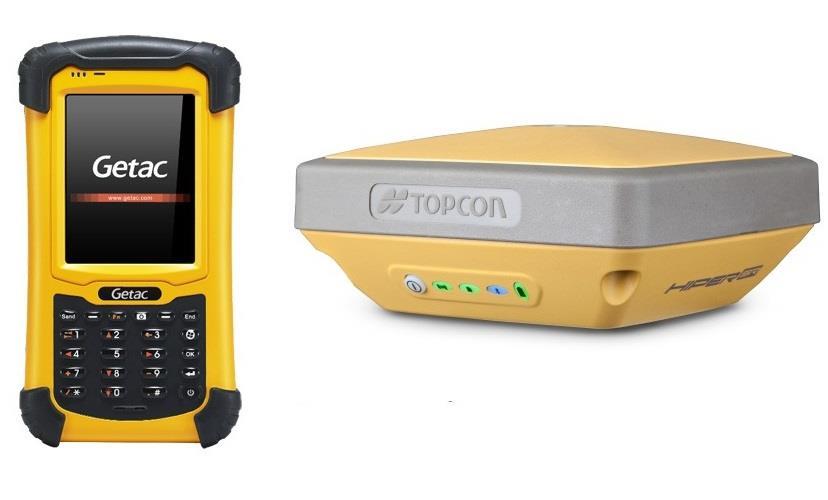
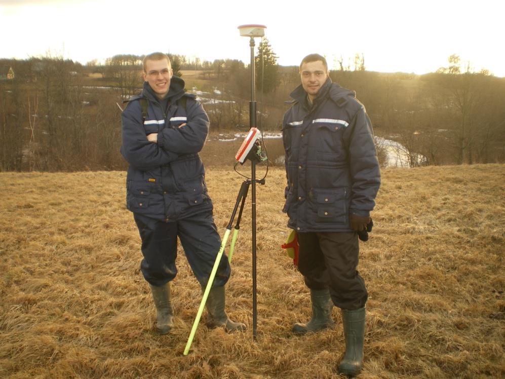
8 Surveying Topcon Hiper SR Trimble S6 Trimble S3


9 Near Surface Geophysics: GPR Equipment Ground Penetrating Radar Zond-12 (Radar Systems, Inc.) 300, 500 & 900 MHz anthennas Services 2D/3D GPR data acquisition Data processing and interpretation Applications non-invasive archaeological surveys pipe, cable location sand dune investigations


10 Near Surface Geophysics: Resistivity Equipment Agi SuperSting Marine 8 channels, 84 electrode. 128 channel Resistivity Imaging System Allied Tigre Services 2D/3D Resistivity data acquisition Data processing and interpretation Applications Engineering-geological surveys Environmental (contamination) studies, Karst region studies


11 Human Resources Geobaltic consists of - One land seismic acquisition crews - One Well-logging crew - Two Drilling crews - Two Surveying crews - One near-surface geophysical crew - Geophysical data processing and interpretation center Geobaltic employs number of professionals with a long history of involvement in international seismic projects
12 Health, Safety and Environment Health safety and environmental protection are primary concerns of Geobaltic. The company has developed a modern, fully integrated Safety Management System for HSE in all aspects of operation procedures, employee policies and quality management.
 and Environmental management systems - Requirements with guidance for use (ISO")
13 Quality management systems and Enviromental management systems Requirements (ISO) JSC "Geobaltic" has been assessed and certified as meeting the requirements of Quality management systems - Requirements (ISO 9001:2008) and Environmental management systems - Requirements with guidance for use (ISO 14001:2004).
14 Completed Seismic Projects Year Client Area Work type 2017 Diseta Gudkaimis, Kudirka-Kybartai license area, Lithuania 17 km 2 3D seismic acquisition, processing and interpretation 2017 Diseta Kybartai, Kudirka-Kybartai license area, Lithuania 36 km 2 3D seismic acquisition, processing and interpretation 2016 TANoil Nemunas, Raseiniai license area, Lithuania 55 km 2D seismic acquisition, processing and interpretation 2016 Diseta Kudirka, Kudirka-Kybartai license area, Lithuania 125 km 2 3D seismic acquisition, processing and interpretation 2015 LL investicijos Barsukinė, Rietavas license area, Lithuania 30 km 2 3D seismic acquisition, processing and interpretation 2014 Klaipėdos University Veiviržėnai license area, Lithuania 20 km 2 3D seismic acquisition, processing and interpretation 2013 TANoil Šimkaičiai, Rietavas license area, Lithuania 80 km 2 3D seismic acquisition, processing and interpretation 2012 Minijos Nafta Gargzdai license area, Lithuania 50 km 2D seismic acquisition, processing and interpretation 2012 LL investicijos Rietavas license area, Lithuania 700 km 2D seismic processing and interpretation 2011 Minijos Nafta Gargzdai license area, Lithuania 45 km 2D seismic acquisition, processing and interpretation 2011 LL investicijos Rietavas license area, Lithuania 50 km 2D seismic acquisition, processing and interpretation 2011 LL investicijos Rietavas license area, Lithuania 250 km 2D seismic processing and interpretation 2011 Manifoldas Klaipeda license area, Lithuania 200 km 2D seismic processing and interpretation 2010 Tethys Oil Gotland Store license area, Sweden 700 km 2D seismic processing and interpretation 2009 Odin Energy A/S Offshore Licence No. 2, Latvia 300 km 2D seismic processing and interpretation 2008 Manifoldas Klaipeda license area, Lithuania 500 km 2D seismic interpretation 2008 Tethys Oil Block 15, Oman 2000 km 2D seismic processing and interpretation 2007 Minijos Nafta Gargzdai license area, Lithuania 500 km 2 3D seismic field QC and interpretation 2007 Tethys Oil Buanane license area, Morocco 400 km 2D seismic processing and interpretation 2006 Tethys Oil License areas 1/02 and 1/03, Denmark Interpretation and prospect mapping of 1500 km 2D data
15 Completed Near Surface Projects Year Client Area Work Type 2012 Research Council of Lithuania Curonian Spit, Lithuania 130 km 2D GPR acquisition, processing and interpretation in sand dunes 2011 Research Council of Lithuania Vilnius, Lithuania 4 hectares of 3D GPR acquisition, processing and interpretation exploring 14th century buried settlement 2010 Prosecution service of Republic of Lithuania Trakai, Lithuania 1 hectare 3D magnetometer survey on the frozen lake locating sunken rifle 2009 Visagino Atomine Elektrine Visaginas Nuclear Power Plant site, Lithuania 15 km 2D Resistivity imaging profiling locating constructional remains 2008 Geostatyba Visaginas Nuclear Power Plant. Site B Lietuvos Dujos Šiauliai, Lithuania 2005-now Different clients North Lithuanian Karst area 0.5 hectare of 3D GPR acquisition locating constructional remains Buried gas pipeline location using 2D GPR survey More than 50 km of 2D Resistivity imaging profiles exploring karst processes in N. Lithuania


16 Contacts UAB Geobaltic Savanoriu 11A-76 Vilnius, LT LITHUANIA Tel.: Website:
international geophysical services
 international geophysical services Prospectiuni Facts & Figures 65 years and still growing Experience in 38 countries, with operations in 8 to 10 countries each year No. 1 geological and geophysical services
Geophysical, Geological and Environmental Services
 Geophysical, Geological and Environmental Services Experience KAZAKHSTAN MOLDOVA CROATIA SERBIA ROMANIA MONTENEGRO BULGARIA F.Y.R.O.M. ALBANIA ARMENIA PORTUGAL GREECE TURKEY SYRIA IRAN AFGHANISTAN MOROCCO
Discovering the Earth s Resources. Geophysical, Geological and Environmental Services
 Geophysical, Geological and Environmental Services Services Overview Prospectiuni SA is the leading geophysical and geological service company in South Eastern Europe with 60 years of experience of international
TNG-Group is one of the leading oilfield servicing companies in the Russian Federation with more than sixty-years history and annual turnover
 TNG-Group is one of the leading oilfield servicing companies in the Russian Federation with more than sixty-years history and annual turnover exceeding 400,000,000.00 USD. Rich production experience, wide
Geophysical Site Surveys
 Geophysical Site Surveys Simon Oakley Geoscience Team Leader Fugro Survey Limited 16/04/2014 Contents Menu Introduction Section 1 - Geophysical Site Surveys - Seabed Bathymetry - Shallow Geology - Seabed
Planning and Operating a Transition Zone 2D Seismic Survey on Lake Tanganyika*
 Planning and Operating a Transition Zone 2D Seismic Survey on Lake Tanganyika* Doug Roberts 1 and Jeremy P. FitzPatrick 2 Search and Discovery Article #41765 (2016) Posted January 25, 2016 *Adapted from
Geophysical Site Investigation (Seismic methods) Amit Prashant Indian Institute of Technology Gandhinagar
 Amit Prashant Indian Institute of Technology Gandhinagar") Geophysical Site Investigation (Seismic methods) Amit Prashant Indian Institute of Technology Gandhinagar Short Course on Geotechnical Aspects of Earthquake Engineering 04 08 March, 2013 Seismic Waves
Geophysical Site Investigation (Seismic methods) Amit Prashant Indian Institute of Technology Gandhinagar Short Course on Geotechnical Aspects of Earthquake Engineering 04 08 March, 2013 Seismic Waves
Dolores Public Lands Office Highway 184 Dolores, CO Ph (970) Fax (970)
 Fax (970)") USDA Forest Service San Juan National Forest Mancos/Dolores Ranger District http://www.fs.fed.us/r2/sanjuan Dolores Public Lands Office 29211 Highway 184 Dolores, CO 81323 Ph (970) 882-7296 Fax (970) 882-6841
USDA Forest Service San Juan National Forest Mancos/Dolores Ranger District http://www.fs.fed.us/r2/sanjuan Dolores Public Lands Office 29211 Highway 184 Dolores, CO 81323 Ph (970) 882-7296 Fax (970) 882-6841
Common Exploration Methods.
 Common Exploration Methods. The following list contains the most common methods which a company with a mineral prospecting licence in Northern Ireland might use to carry out a mineral prospecting programme.
Seismoelectric Ground-flow DC-4500 Locator
 Seismoelectric Ground-flow DC-4500 Locator Introduction The seismoelectric survey is a new technology combined the electro kinetic potential method and geophysical technology. It is applied directly to
FINAL REPORT GEOPHYSICAL INVESTIGATION WATER TOWER NO. 6 SITE PLANT CITY, FL
 APPENDIX B FINAL REPORT GEOPHYSICAL INVESTIGATION WATER TOWER NO. 6 SITE PLANT CITY, FL Prepared for Madrid Engineering Group, Inc. Bartow, FL Prepared by GeoView, Inc. St. Petersburg, FL February 28,
High Resolution Geophysics: A Better View of the Subsurface. By John Jansen, P.G., Ph.D., Aquifer Science and Technology
 High Resolution Geophysics: A Better View of the Subsurface By John Jansen, P.G., Ph.D., Aquifer Science and Technology Geologist Use Only Part of the Information Available To Them Most Geologist rely
BAUER MeBo Sea Bed Drill Rig
 BAUER MeBo Sea Bed Drill Rig Spotlights BAUER Maritime Experiences 1993 Diamond deposit exploration with a BC cutter in water depth of 160 m (South Africa) Atlantic Ocean 2005 Drilling inside of a monopile
Holocene dune reactivation along the northern Curonian Spit: geological, paleoecological, and archaeological implications
 Holocene dune reactivation along the northern Curonian Spit: geological, paleoecological, and archaeological implications Ilya Buynevich Temple University (USA) Collaborators: Albertas Bitinas Donatas
about GCC
 about GCC Bldg 234, Flat 11, Al Barakat Street, Hail Al Janaubiyah P.O Box: 94, Postal Code: 123, Al Khaudh, Sultante of Oman Fax : +968 24543188 Mobile :+968 96666445 info@gcc-oman.com www.gcc-oman.com
Earthquake Commission Darfield Earthquake Recovery Geotechnical Factual Report New Brighton
 REPORT Earthquake Commission Darfield Earthquake Recovery Geotechnical Factual Report New Brighton REPORT Earthquake Commission Darfield Earthquake Recovery Geotechnical Factual Report New Brighton Report
Environmental protection through the use of technology. Modular polyvalent and adaptable solutions for any needs
 Environmental protection through the use of technology Modular polyvalent and adaptable solutions for any needs Socially responsible: we promote the well-being of territory where we work Certified quality
Yev Kontar. Illinois State Geological Survey, University of Illinois at Urbana-Champaign
 Addressing Caribbean Geophysical Hazards through the Continuously Operating Caribbean GPS Observational Network (COCONet) and International Ocean Drilling Program (IODP) Yev Kontar Illinois State Geological
Identified a possible new offset location where the customer is currently exploring drill options.
 GroundMetrics was hired to conduct a Full-Field Resistivity Survey for an oil and gas producer that needed to make crucial decisions to drive profitability at the location. The results saved them hundreds
Walkaway Seismic Experiments: Stewart Gulch, Boise, Idaho
 Walkaway Seismic Experiments: Stewart Gulch, Boise, Idaho Lee M. Liberty Center for Geophysical Investigation of the Shallow Subsurface Boise State University Boise, Idaho 1. Summary CGISS conducted walkaway
National Geophysical Survey Science Opportunities
 National Geophysical Survey Science Opportunities Anton Ziolkowski Professor of Petroleum Geoscience University of Edinburgh BGS Keyworth 4 April 2016 Outline Brief biography Science opportunities High
Introduction to Oil&Gas Well Drilling
 Introduction to Oil&Gas Well Drilling Drilling Introduction to Oil&Gas Well Drilling The term drilling indicates the whole complex of operations necessary to construct wells of circular section applying
SEISMIC SURVEYS FOR IMAGING THE REGOLITH
 SEISMIC SURVEYS FOR IMAGING THE REGOLITH Barry Drummond Geoscience Australia. PO Box 378, Canberra, ACT 2601. E-mail: barry.drummond@ga.gov.au 1. INTRODUCTION Seismic reflection and refraction imaging
3-D seismic data acquisition, with special reference to recovery programme, in Contai area, Bengal Basin, India
 P - 352 3-D seismic data acquisition, with special reference to recovery programme, in Contai area, Bengal Basin, India *A. K. Roy, S. Shanmugaswamy, T. R. Verma,Y.P. Babu, & B. K. Sharma, ONGC, akroy_ongc@yahoo.co.in
PETROLEUM 101. Mark Shrimpton Jacques Whitford
 PETROLEUM 101 Mark Shrimpton Jacques Whitford PRESENTATION STRUCTURE The Offshore Petroleum Industry Petroleum Geology Petroleum Technology: Exploration agreements Geophysical exploration Drilling Development
MANAGEMENT OF THE NIEMEN RIVER BASIN WITH ACCOUNT OF ADAPTATION TO CLIMATE CHANGE. Hydro-meteorological Monitoring System
 MANAGEMENT OF THE NIEMEN RIVER BASIN WITH ACCOUNT OF ADAPTATION TO CLIMATE CHANGE Hydro-meteorological Monitoring System Draft Interim Report Milestone 1 Giovanni Crema 18 October 2012 Scope of work assessment
MOUNT POLLEY MINING CORPORATION TECHNICAL REPORT ON MULTI-ELECTRODE RESISTIVITY AND SEISMIC REFRACTION SURVEYS MOUNT POLLEY TAILINGS DAM PROJECT
 MOUNT PLEY MINING CORPORATION TECHNICAL REPORT ON MULTI-ELECTRODE RESISTIVITY AND SEISMIC REFRACTION SURVEYS MOUNT PLEY TAILINGS DAM PROJECT LIKELY, B.C. by Claudia Krumbiegel, M.Sc. Cliff Candy, P.Geo.
SwedSTORE CO2 : Plans for a Swedish onshore test site for CO 2 storage via seismic surveying and drilling on Gotland, Sweden
 SwedSTORE CO2 : Plans for a Swedish onshore test site for CO 2 storage via seismic surveying and drilling on Gotland, Sweden Christopher Juhlin (Uppsala University) 1 SwedSTORE CO2 Goals Advance methods
Oil and Gas Research Institute Seismic Analysis Center Faults Detection Using High-Resolution Seismic Reflection Techniques
 Oil and Gas Research Institute Seismic Analysis Center Faults Detection Using High-Resolution Seismic Reflection Techniques Ghunaim T. Al-Anezi (KACST) March 2013 1 Objectives The objective of the survey
LECTURE 10. Module 3 : Field Tests in Rock 3.6 GEOPHYSICAL INVESTIGATION
 LECTURE 10 3.6 GEOPHYSICAL INVESTIGATION In geophysical methods of site investigation, the application of the principles of physics are used to the study of the ground. The soil/rock have different characteristics
X040 Buried Sources and Receivers in a Karsted Desert Environment
 X040 Buried Sources and Receivers in a Karsted Desert Environment C. Berron* (CGGVeritas Services S.A.), E. Forgues (CGGVeritas Services S. A.), M. Jervis (Saudi Aramco), A. Bakulin (Saudi Aramco) & R.
Initial Borehole Drilling and Testing in Central Huron,
 JULY 2016 PRELIMINARY ASSESSMENT OF POTENTIAL SUITABILITY Initial Borehole Drilling and Testing in Central Huron, Huron-Kinloss and South Bruce DRAFT FOR DISCUSSION WITH COMMUNITIES In 2012, at the request
Site Characterization & Hydrogeophysics
 Site Characterization & Hydrogeophysics (Source: Matthew Becker, California State University) Site Characterization Definition: quantitative description of the hydraulic, geologic, and chemical properties
IMPROVEMENT OF SEISMIC DATA QUALITY USING PRIOR TEST SHOT INFORMATION IN HIGHLY UNPREDICTABLE WEATHERING LAYER (A
 MESHWA RIVER IMPROVEMENT OF SEISMIC DATA QUALITY USING PRIOR TEST SHOT INFORMATION IN HIGHLY UNPREDICTABLE WEATHERING LAYER (A Case Study from Cambay Basin, India) Authors: Manoj Maurya*, Arati Srivastava,
INTRODUCTION TO APPLIED GEOPHYSICS
 INTRODUCTION TO APPLIED GEOPHYSICS EXPLORING THE SHALL0W SUBSURFACE H. Robert Burger Anne F. Sheehan Craig H.Jones VERSITY OF COLORADO VERSITY OF COLORADO W. W. NORTON & COMPANY NEW YORK LONDON Contents
Petrophysical Data and Open Hole Logging Operations Basics COPYRIGHT. Introduction to Petrophysical Data and Open Hole Logging Operations Basics
 Learning Objectives Petrophysical Data and Open Hole Logging Operations Basics Introduction to Petrophysical Data and Open Hole Logging Operations Basics By the end of this lesson, you will be able to:
Geophysics for Environmental and Geotechnical Applications
 Geophysics for Environmental and Geotechnical Applications Dr. Katherine Grote University of Wisconsin Eau Claire Why Use Geophysics? Improve the quality of site characterization (higher resolution and
ELECTRICAL RESISTIVITY SURVEY OF INTREPID POTASH INJECTION WELL SITE: EDDY COUNTY, NEW MEXICO
 NCKRI REPORT OF INVESTIGATION 3 ELECTRICAL RESISTIVITY SURVEY OF INTREPID POTASH INJECTION WELL SITE: EDDY COUNTY, NEW MEXICO www.nckri.org NATIONAL CAVE AND KARST RESEARCH INSTITUTE REPORT OF INVESTIGATION
Integrated Company Profile
 Integrated Company Profile 2016 Mintec Abadi All right reserved Vision Mission Slogan Core values One-stop Mining Engineering Services We contribute to maximize the value of Indonesia s natural resources
T: E:
 PAS 128 UTILITY DETECTION AND MAPPING TOPOGRAPHICAL SURVEYS UTILITY RECORD SEARCHES AND DESK TOP STUDY SURFACE WATER DRAINAGE SURVEYS GROUND CLEARANCE SURVEYS MEASURED BUILDING SURVEYS LASER SCANNING UAV
Environmental Geophysics for Coastal Management
 Environmental for Coastal Management Paul Donaldson 1, Dr Douglas Bergersen 2, Dr Matthew Barnes 3, Conor Jones 3 Coast To Coast, Hobart April 2018 1 BMT Newcastle, Australia, 2 Acoustic Imaging, Cooroy,
Programmatic Approaches to Assessing and Mitigating Risk to Pipelines from Natural Forces
 Programmatic Approaches to Assessing and Mitigating Risk to Pipelines from Natural Forces 23 rd International Petroleum Environmental Conference New Orleans, Louisiana November 8-10, 2016 Introduction
VMS-GeoMil. Background
 Background When using a drilling rig for cone penetration testing, a mechanical clamp can be mounted to the drilling head (by means of a special transition piece). The depth than can be achieved depends
Site Investigations for Offshore Wind
 Site Investigations for Offshore Wind A multi-disciplinary approach Mattijs de Lange Gardline Marine Sciences Limited My thanks to: Maarten Timmerman David Cerda Saltzman Sue Crothers Albert van der Hem
Geophysics for Land Development
 Geophysics for Land Development About Us Whatever your area of interest GBGMAPS can provide advanced subsurface and structural geophysical solutions to add value to your product. Mining and infrastructure
Geophysical Applications GPR Ground Penetrating Radar
 Overview: Basics of GPR Radar-wave velocity, attenuation and skin depth Modes of acquisition The Radar-range equation Dielectric properties of materials and relation to porosity Case studies [Archeology,
Feasibility and design study of a multicomponent seismic survey: Upper Assam Basin
 P-276 Summary Feasibility and design study of a multicomponent seismic survey: Upper Assam Basin K.L.Mandal*, R.K.Srivastava, S.Saha, Oil India Limited M.K.Sukla, Indian Institute of Technology, Kharagpur
UNIVERSITY OF WISCONSIN SYSTEM SOLID WASTE RESEARCH PROGRAM Student Project Report. A Search for Industrial Waste and Buried Logs in Rib Lake
 UNIVERSITY OF WISCONSIN SYSTEM SOLID WASTE RESEARCH PROGRAM Student Project Report A Search for Industrial Waste and Buried Logs in Rib Lake July 2015 Student Investigators: Drake Bortolameolli and Sean
Sabal Trail Pipeline Project Evaluation of Karst Topography and Sinkhole Potential for Pipeline and Facilities
 November 11, 2014 Sabal Trail Pipeline Project Evaluation of Karst Topography and Sinkhole Potential for Pipeline and Facilities Gulf Interstate Engineering Attention: Mr. Denys Stavnychyi - Project Engineer
3D land seismic with low environmental impact: a case study from the Murchison Falls National Park, Uganda
 P1-2-12 3D land seismic with low environmental impact: a case study from the Murchison Falls National Park, Uganda Keith Mills 1, Abderrahim Lafram 2, Michael Igoe 3, Sharon Cooper 1, Louise Moorhead 1,
Country Fiche Lithuania
 Country Fiche Lithuania Updated June 2018 1. General information The Lithuanian maritime space is delimited by the Decree of the Government of the Republic of Lithuania of 6 December, 2004, No. 1597 and
HORDA SURVEY HERALDS NEW STRATEGY
 HORDA SURVEY HERALDS NEW STRATEGY CGG sets sights on multi-client market leadership in Norway BY IDAR HORSTAD, ERLING FRANTZEN AND JO FIRTH, CGG 12 seismic profile Figure 1: Reprocessing of the Cornerstone
What can I do with a major in Earth Information Science?
 Lewis-Clark State College offers a Bachelor of Arts or Science Degree in Earth Information Science through the Natural Sciences and Mathematics Division. You can learn more about the Natural Sciences and
In-seam GPR and 2-C seismic investigations at the Goderich, Ontario salt mine
 In-seam GPR and 2-C seismic investigations at the Goderich, Ontario salt mine Jill Belisle and Robert R. Stewart In-seam techniques ABSTRACT In-seam GPR and 2-C seismic techniques used in conjunction with
3-D ground-penetrating radar surveys on a frozen river lagoon
 3-D ground-penetrating radar surveys on a frozen river lagoon Monica Moldoveanu and Robert R. tewart ABTRACT Ground-penetrating radar (GPR) surveys were acquired at Bowness Park, Calgary to characterize
MINISTRY FOR INVESTMENTS AND DEVELOPMENT OF THE REPUBLIC OF KAZAKHSTAN. Investments into exploration in Kazakhstan
 MINISTRY FOR INVESTMENTS AND DEVELOPMENT OF THE REPUBLIC OF KAZAKHSTAN Investments into exploration in Kazakhstan Astana, 2017 Increasing the transparency of subsoil use sphere V Accession to the global
Geoelectric power generation prospects in Lithuania
 Geoelectric power generation prospects in Lithuania Saulius Šliaupa Nature research centre Develop Geothermal Electricity in Europe to have a renewable energy mix Workshop Lithuania, Latvia, Estonia, Finland,
Summary of Indium Soil Vapor Monitoring Points Decommissioning Former Lockheed Martin French Road Facility Utica, NY
 Stantec Consulting Services Inc. 61 Commercial Street, Suite 100, Rochester NY 14614-1009 September 2, 2015 File: 190500800 New York State Department of Environmental Conservation Division of Environmental
Comparison of geophysical. techniques to determine depth to. bedrock in complex weathered. environments of the Mount Crawford. region, South Australia
 Comparison of geophysical techniques to determine depth to bedrock in complex weathered environments of the Mount Crawford region, South Australia Thesis submitted in accordance with the requirements of
Seismic Interpretation & Exploration
 Seismic Interpretation & Exploration Ecolog is a private consulting and design firm established in 2002, with a track record of designing, managing and executing exploration activities and geophysical-geological
Seismic Sources. Seismic sources. Requirements; Principles; Onshore, offshore. Reading: Telford et al., Section 4.5 Sheriff and Geldart, Chapter 7
 Seismic Sources Seismic sources Requirements; Principles; Onshore, offshore. Reading: Telford et al., Section 4.5 Sheriff and Geldart, Chapter 7 Seismic Source Localized region within which a sudden increase
Geophysical Methods for Screening and Investigating Utility Waste Landfill Sites in Karst Terrain
 Geophysical Methods for Screening and Investigating Utility Waste Landfill Sites in Karst Terrain Gary Pendergrass, PE, RG, F.NSPE Principal Geological Engineer Kansas City Geotechnical Conference 2017
GEOL4714 Final Exam Fall 2005, C. H. Jones instructor
 GEOL4714 Final Exam Fall 2005 p. 1 GEOL4714 Final Exam Fall 2005, C. H. Jones instructor Name: Student ID #: Feel free to use the back of the sheets for answers needing more space. (1) (10 pts) For each
Hydrofest The Hydrographic Society in Scotland
 Hydrofest 2017 The Hydrographic Society in Scotland Offshore Survey in the Oil and Gas Industry Hydrofest 2017 Chris Leaf Head Offshore Surveys Shell Projects and Technology, Europe Presentation Overview
3. EVOLUTION In 1948 the basic mechanical cone was developed (Figure 1) and this cone is still in use today as the
 and this cone is still in use today as the") 1. WHAT IS CPT? A CPT is carried out by pushing a calibrated cone vertically into the ground and measuring the forces applied on its conical tip, the friction on the sides of the cone and, if using a piezocone,
1. WHAT IS CPT? A CPT is carried out by pushing a calibrated cone vertically into the ground and measuring the forces applied on its conical tip, the friction on the sides of the cone and, if using a piezocone,
For personal use only
 19 October 2011 AOM to expand into Shale Gas Exploration The Directors of (ASX:AOM) are pleased to announce the Company has entered into an agreement with Dr David Falvey to establish a subsidiary company,
Module 1 : Site Exploration and Geotechnical Investigation
 Objectives In this section you will learn the following Displacement borings Wash boring Auger boring Rotary drilling Percussion drilling Continuous sampling Boring methods of exploration The boring methods
An Overview of Geomatics Involvement in the Offshore Oil & Gas Industry
 An Overview of Geomatics Involvement in the Offshore Oil & Gas Industry David Whitcombe Head Offshore Surveys - Europe Explore Appraise Develop ProduceDecommission Content Overview Oil & Gas Industry Geomatics
IMAGING OF DEEP SINKHOLES USING THE MULTI-ELECTRODE RESISTIVITY IMPLANT TECHNIQUE (MERIT) CASE STUDIES IN FLORIDA
 CASE STUDIES IN FLORIDA") IMAGING OF DEEP SINKHOLES USING THE MULTI-ELECTRODE RESISTIVITY IMPLANT TECHNIQUE (MERIT) CASE STUDIES IN FLORIDA David Harro The G3 Group, 2509 Success Drive, Suite 1, Odessa, FL 33556, david.harro@geo3group.com
IMAGING OF DEEP SINKHOLES USING THE MULTI-ELECTRODE RESISTIVITY IMPLANT TECHNIQUE (MERIT) CASE STUDIES IN FLORIDA David Harro The G3 Group, 2509 Success Drive, Suite 1, Odessa, FL 33556, david.harro@geo3group.com
Petroleum Exploration
 Petroleum Exploration Upstream Petroleum Exploration The role of exploration is to provide the information required to exploit the best opportunities presented in the choice of areas, and to manage research
Mineralogical Anomalies in Sands: Implications for Vertebrate Ichnology
 Mineralogical Anomalies in Sands: Implications for Vertebrate Ichnology Recent Tracks in HMCs Curonian Lagoon, Lithuania Baltic Sea 20 km mustelid (mink?) Lithuania Russia suid (wild boar) canid (red fox)
PG&E OFFSHORE CENTRAL COASTAL CALIFORNIA SEISMIC IMAGING PROJECT
 PG&E OFFSHORE CENTRAL COASTAL CALIFORNIA SEISMIC IMAGING PROJECT Public Scoping Meeting California State Lands Commission July 21, 2011 Project Area Project Commitments Assessment of the Hosgri, Shoreline,
Saulius Šliaupa, Rasa Šliaupienė (NRC, Lithuania) Uldis Nulle, Inara Nulle (LEGMC, Latvia) Alla Shogenov, Kazbulat Shogenov (IGTUT, Estonia)
 Uldis Nulle, Inara Nulle (LEGMC, Latvia) Alla Shogenov, Kazbulat Shogenov (IGTUT, Estonia)") CO 2 Capture and Storage Response to Climate Change CGS Europe workshop 13 14 April 2011, Vilnius - Verkiai, Lithuania CO 2 storage potential of deep saline aquifers of the Baltic region Saulius Šliaupa,
CO 2 Capture and Storage Response to Climate Change CGS Europe workshop 13 14 April 2011, Vilnius - Verkiai, Lithuania CO 2 storage potential of deep saline aquifers of the Baltic region Saulius Šliaupa,
indigeo Consultants Pvt Ltd Geophysical Surveys Geological Surveys GIS & Data Solutions Image Processing indigeo Company Profile, Page 1
 indigeo Consultants Pvt Ltd Geophysical Surveys Geological Surveys GIS & Data Solutions Image Processing MM Corner, 3 rd Floor #58, Banaswadi Main Road Bangalore 560033 INDIA Ph: +91 80 41638310 Mob: +91
OWNER OPERATOR: BLACKWATER EXPLORATIONS LTD. REPORT ON SEISMIC REFRACTION SURVEY PLACER GOLD EXPLORATION
 OWNER OPERATOR: BLACKWATER EXPLORATIONS LTD. REPORT ON SEISMIC REFRACTION SURVEY PLACER GOLD EXPLORATION CARIBOO MINING DISTRICT NTS 93G CLAIM PC682023 Latitude 53 13 35.64 Longitude 122 49 40.65 by Russell
Aboriginal communities strengthen governance with location-based tools in the 21st century
 Aboriginal communities strengthen governance with location-based tools in the 21st century Today, Aboriginal communities are taking advantage of the geomatics technologies that underpin popular online
M E M O R A N D U M. Mr. Jonathan K. Thrasher, P.E., Mr. Ian Kinnear, P.E. (FL) PSI
 PSI") M E M O R A N D U M TO: FROM: Mr. Mark Schilling Gulf Interstate Engineering Mr. Jonathan K. Thrasher, P.E., Mr. Ian Kinnear, P.E. (FL) PSI DATE: November 11, 2014 RE: Summary of Findings Geotechnical
M E M O R A N D U M TO: FROM: Mr. Mark Schilling Gulf Interstate Engineering Mr. Jonathan K. Thrasher, P.E., Mr. Ian Kinnear, P.E. (FL) PSI DATE: November 11, 2014 RE: Summary of Findings Geotechnical
Coastal data for Integrated Maritime Policies
 Coastal data for Integrated Maritime Policies LOCHET Corine Shom Name of presentation Protection against erosion and marine flood Name presenter Link between different data scales and Name of presentation
The Petroleum Industry. Phonse Fagan, P. Geo. President A.J. Fagan Consulting Inc. and
 The Petroleum Industry by Phonse Fagan, P. Geo. President A.J. Fagan Consulting Inc. and Terminology Petroleum Natural Gas Oil Crude Hydrocarbons http://www.kerrheating.com/products/fuel_oil_tanks_liberty.htm
Site characterization at the Groundwater Remediation Field Laboratory
 Site characterization at the Groundwater Remediation Field Laboratory WILLIAM P. C LEMENT, STEVE CARDIMONA, ANTHONY L. ENDRES, Boston College, Boston, Massachusetts KATHARINE KADINSKY-CADE, Phillips Laboratory,
An Introduction to Geophysical Exploration
 An Introduction to Geophysical Exploration Philip Kearey Department of Earth Sciences University of Bristol Michael Brooks Ty Newydd, City Near Cowbridge Vale of Glamorgan Ian Hill Department of Geology
Offshore Operations and Project Execution Geophysical Site Surveys
 Offshore Operations and Project Execution Geophysical Site Surveys Chris Almond Senior Geophysicist Fugro Survey Limited 22/04/2015 Presentation Summary: Office-based Personnel Project Awarded Pre Offshore
OTTO AT A GLANCE COMPANY OFFICERS. By E-Lodgement
 13 December 2012 Manager of Company Announcements ASX Limited Level 6, 20 Bridge Street SYDNEY NSW 2000 By E-Lodgement OTTO-OPERATED JOINT VENTURE APPROVES DRILLING OF THE DUHAT-2 EXPLORATION WELL IN MID-2013
BUREAU OF MINERAL RESOURCES, GEOLOGY AND GEOPHYSICS
 COMMONWEALTH OF AUSTRALIA DEPARTMENT OF NATIONAL DEVELOPMENT BUREAU OF MINERAL RESOURCES, GEOLOGY AND GEOPHYSICS RECORD No. 1952/35 PRELIMINARY REPORT ON SEISMIC REFLECTION SURVEY, AVON AREA, GIPPSLAND,
Initial Borehole Drilling and Testing in or Near Ignace
 JUNE 2016 PRELIMINARY ASSESSMENT OF POTENTIAL SUITABILITY Initial Borehole Drilling and Testing in or Near Ignace DRAFT FOR DISCUSSION WITH COMMUNITIES In 2010, the Nuclear Waste Management Organization
Initial Borehole Drilling in the Hornepayne and Manitouwadge Area
 MAY 2017 PRELIMINARY ASSESSMENT OF POTENTIAL SUITABILITY Initial Borehole Drilling in the Hornepayne and Manitouwadge Area In 2010, the Nuclear Waste Management Organization (NWMO) began technical and
P Forsmark site investigation. Ground penetrating radar and resistivity measurements for overburden investigations
 P-03-43 Forsmark site investigation Ground penetrating radar and resistivity measurements for overburden investigations Johan Nissen, Malå Geoscience AB April 2003 Svensk Kärnbränslehantering AB Swedish
A GPR ASSESSMENT OF THE PREHISTORIC NAPLES CANAL NAPLES, FLORIDA ARCHAEOLOGICAL AND HISTORICAL CONSERVANCY, INC.
 A GPR ASSESSMENT OF THE PREHISTORIC NAPLES CANAL NAPLES, FLORIDA ARCHAEOLOGICAL AND HISTORICAL CONSERVANCY, INC. AHC TECNICAL REPORT NO. 1004 DECEMBER 2013 A GPR ASSESSMENT OF THE PREHISTORIC NAPLES CANAL
The role of seismic in unconventional reservoir development
 The role of seismic in unconventional reservoir development Mike Perz Director, Technology & Innovation, Multi-client, Onshore February 23, 2018 Outline Introduction Seismic s adaptation to the unconventional
Drillworks. DecisionSpace Geomechanics DATA SHEET
 DATA SHEET Drillworks overview DecisionSpace Geomechanics Key features Pre-drill, real-time, and post-drill analyses are all easily performed in one application using the latest data from across the field
Sabal Trail Pipeline Project Evaluation of Karst Topography and Sinkhole Potential for Pipeline and Facilities
 November 11, 2014 Sabal Trail Pipeline Project Evaluation of Karst Topography and Sinkhole Potential for Pipeline and Facilities Gulf Interstate Engineering Attention: Mr. Denys Stavnychyi - Project Engineer
Geologic Management. Contents
 Geologic Management Contents Introduction... GM-3 Definitions... GM-3 Legislation and Other Guidance... GM-3 Policy Management for Representation... GM-5... GM-5 Inventory of Significant Geologic Features
CCR Rule Compliance: Innovative Use of Geophysics to Certify Landfill Stability and Site Groundwater Monitoring Wells
 CCR Rule Compliance: Innovative Use of Geophysics to Certify Landfill Stability and Site Groundwater Monitoring Wells Gary Pendergrass, PE, RG Principal Geological Engineer Missouri Waste Control Coalition
Geophysics. Geotechnics. Geophysics. Earthworks. Environment. Groundwater. Rock Mechanics. Integrated Practical Solutions
 Geophysics Geotechnics Environment Groundwater Rock Mechanics Geophysics Earthworks Integrated Practical Solutions Geophysics Services Our 50 years of experience gained over 100,000 completed projects,
IN SITU TESTING TECHNOLOGY FOR FOUNDATION & EARTHQUAKE ENGINEERING. Wesley Spang, Ph.D., P.E. AGRA Earth & Environmental, Inc.
 IN SITU TESTING TECHNOLOGY FOR FOUNDATION & EARTHQUAKE ENGINEERING Wesley Spang, Ph.D., P.E. AGRA Earth & Environmental, Inc. Portland, Oregon In situ testing of soil, which essentially consists of evaluating
HUNTER GEOPHYSICS. Specialists in unmarked grave detection and archaeological prospection. GEOPHYSICAL SURVEY REPORT [redacted] Cemetery SITE NAME
![HUNTER GEOPHYSICS. Specialists in unmarked grave detection and archaeological prospection. GEOPHYSICAL SURVEY REPORT [redacted] Cemetery SITE NAME](/thumbs/91/106672061.jpg "HUNTER GEOPHYSICS. Specialists in unmarked grave detection and archaeological prospection. GEOPHYSICAL SURVEY REPORT [redacted] Cemetery SITE NAME") HUNTER GEOPHYSICS Specialists in unmarked grave detection and archaeological prospection PO Box 1445, Central Park, Victoria 3145 Ph.: (03) 9913 2259 or Mob.: 0488 501 261 david.hunter@huntergeophysics.com
HUNTER GEOPHYSICS Specialists in unmarked grave detection and archaeological prospection PO Box 1445, Central Park, Victoria 3145 Ph.: (03) 9913 2259 or Mob.: 0488 501 261 david.hunter@huntergeophysics.com
Seismic Data Acquisition In Complex Boulder Bed Area: A Case Study In Arunachal Pradesh, North East INDIA
 P-206 Seismic Data Acquisition In Complex Boulder Bed Area: A Case Study In Arunachal Pradesh, North East INDIA Summary G.K.Ghosh*, D. N. Saroj, A.K.Khanna and R. Das gupta, Oil India Limited The area
Exploration, Drilling & Production
 Nontechnical Guide to PETMOLEUM Geology, Exploration, Drilling & Production Third Edition Norman J. Hyne, Ph.D. Contents Preface *i Introduction 1 The Nature of Gas and Oil 1 Petroleum 1 The Chemistry
EXTREMELY FAST IP USED TO DELINEATE BURIED LANDFILLS. Norman R. Carlson, Cris Mauldin Mayerle, and Kenneth L. Zonge
 EXTREMELY FAST IP USED TO DELINEATE BURIED LANDFILLS Norman R. Carlson, Cris Mauldin Mayerle, and Kenneth L. Zonge Zonge Engineering and Research Organization, Inc. 3322 East Fort Lowell Road Tucson, Arizona,
Geophysical Exploration in Water Resources Assessment. John Mundell, P.E., L.P.G., P.G. Ryan Brumbaugh, L.P.G. Mundell & Associates, Inc.
 Geophysical Exploration in Water Resources Assessment John Mundell, P.E., L.P.G., P.G. Ryan Brumbaugh, L.P.G. Mundell & Associates, Inc. Presentation Objective Introduce the use of geophysical survey methods