2012 COAST survey MGL1212 Cascadia Open-Access Seismic Transect off Grays Harbor Washington
|
|
|
- Reynard Hunter
- 5 years ago
- Views:
Transcription

1 2012 COAST survey MGL1212 Cascadia Open-Access Seismic Transect off Grays Harbor Washington

2
3 Ten (ish...) lines collected over 12 days Single 8 km streamer for MCS Multibeam bathymetry & backscatter, gravity Collected as a community survey or open access project
4 Ongoing work on COAST survey data S. Holbrook, H. Tobin, K. Keranen, S. Webb, E. Everson, W. Fortin, D. Peterson (MGG) Time and Depth imaging, Structural intepretation, and Velocity inversion P Johnson & M. Salmi (MGG) Thermal Modeling and Heat Flow of the Washington Margin COAST BSR analysis and seafloor imagery J. Caplan-Auerbach & A. Ypma Gravity modeling C. Goldfinger & J. Beeson Surface slope failures from multibeam imagery


5 COAST Survey imaged offshore central WA in high resolution: central portion of margin where wedge is very low taper, landwardvergent thrusting Shallow sedimentation into (interconnected) super-wedge basins suppresses deformation, supports build-out of landward vergent zone Top of lower plate basement imaged; no strong decollement reflection in sediments observed in most areas; varying position of detachment level


6 PreStack Time Migration performed by GeoTrace has greatly improved imaging through better velocities, multiple suppression, wavelet improvements Only Lines 3 & 4 available: a deal to do more fell through

7 Webb, Tobin, et al. work in progress
8 Webb, Tobin, et al. work in progress

9 Webb, Tobin, et al. work in progress


10 E. Everson, Un. of Wyoming
 Inverted model (black) 1-sigma error (cyan) Selection from final inverted velocity model.")
11 COAST velocity inversion: Fortin et al., Un. of Wyoming Seafloor Initial model (red) Inverted model (black) 1-sigma error (cyan) Selection from final inverted velocity model. Notice the capture of stratigraphy and lower velocities at ~78 km in a region of undeformed sediments. Fortin et al., in prep.

12 Porosity model and calculated porosity anomalies (or lack thereof) - Porosity from inverted velocity (PSDM preliminary values give similar result) - If we assume a normal consoidation in the Cascadia basin, then no anomalously high porosity is detected in wedge i.e., no evidence for overpressure anywhere Webb, Tobin, et al. work in progress
13 o Velocity work so far (snmo analysis, preliminary PSDM, waveform inversion) all work indicates unusually high Vp in base of outer wedge at ~ 4000 m/s o No basal LVZ detected (so far) maybe in landward portions via Cornell group work o Wedge taper of 3 o Strong wedge over extremely weak base promotes potential for rupture propagation to the tip of the wedge?
14 Deep Energy in CDP gathers Plate Interface Plate boundary package Peterson, Keranen, et al.,work in progress

15 Mapping Deep Energy in CDP gathers Peterson, Keranen, et al.,work in progress

16 Possible correlation landward Peterson, Keranen, et al.,work in progress


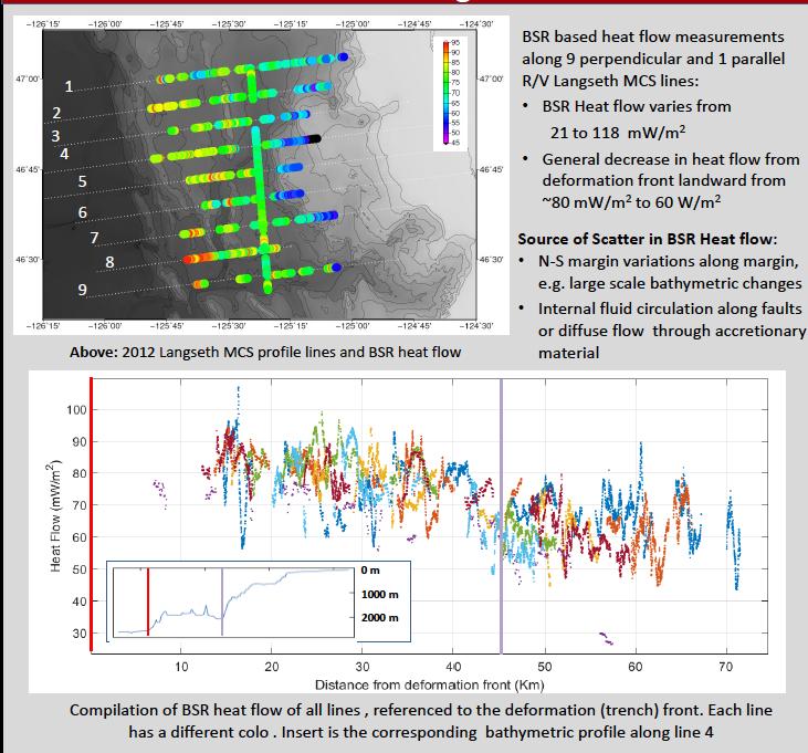
17 Heat Flow Study: Salmi, Harris, Johnson, Solomon (Un. Washington & OSU) Poster T21D-2870 Tuesday morning Probe and BSR-inferred thermal gradients to estimate heat flow and temperature at the plate interface
18

19 Modeled temperature at the plate interface 260 C right at the deformation front! 350 C under lower slope 450 C under shelf Canonical seismogenic locking zone is ~100 C to C

20 Full waveform pre-stack velocity inversions: Lateral velocity increase near deformation front No evidence for deep sediment low velocity zone Fortin et al., in prep

21 Using multibeam bathymetry to map surface morphology of channels and surface failure features Found evidence they interpret as radical erosion events associated with massive turbidity currents Likley timing is end-pleistocene they argue these are Missoula flood related. Beeson, Goldfinger, Fortin, ms. in prep

22 Beeson, Goldfinger, Fortin, ms. In prep

23 Gravity modeling Line 4 Work in progress by Anton Ypma & Jackie Caplan-Auerbach
24 Cornell and Wisconsin COAST: Now and future More detailed structural and stratigraphic analysis of outer wedge and wedge-top basins Analysis of plate boundary reflector via large-offset arrivals PSDM processing for better depth and velocity model Washington & Oregon State Improvements to thermal models Western Washington Ongoing gravity modeling
Seafloor Evidence of Remotely Triggered Slope Failures & Turbidity Currents. Paul Johnson, Joan Gomberg, Susan Hautala, and Marie Salmi
 Seafloor Evidence of Remotely Triggered Slope Failures & Turbidity Currents Paul Johnson, Joan Gomberg, Susan Hautala, and Marie Salmi Why Do We Care? The turbidite record is a key constraint on recurrence
We A10 12 Common Reflection Angle Migration Revealing the Complex Deformation Structure beneath Forearc Basin in the Nankai Trough
 We A10 12 Common Reflection Angle Migration Revealing the Complex Deformation Structure beneath Forearc Basin in the Nankai Trough K. Shiraishi* (JAMSTEC), M. Robb (Emerson Paradigm), K. Hosgood (Emerson
Search and Discovery Article #40536 (2010) Posted June 21, 2010
 Posted June 21, 2010") Modern Examples of Mass Transport Complexes, Debrite and Turbidite Associations: Geometry, Stratigraphic Relationships and Implications for Hydrocarbon Trap Development* Fabiano Gamberi 1, Marzia Rovere
Modern Examples of Mass Transport Complexes, Debrite and Turbidite Associations: Geometry, Stratigraphic Relationships and Implications for Hydrocarbon Trap Development* Fabiano Gamberi 1, Marzia Rovere
June 13-July 8, Astoria-Astoria
 MGL1211: Cascadia Basin Ridge to Trench June 13-July 8, Astoria-Astoria Motivation 1. How does the JdF plate evolve from ridge to trench and is there significant hydration of the crust and upper mantle
Numerical modelling: The governing equation used in this study is: (K T ) c T H 0,
 c T H 0,") GSA DATA REPOSITORY 2012254 Cozzens and Spinelli Numerical modelling: The governing equation used in this study is: (K T ) c T H 0, where K is thermal conductivity, T is temperature, ρ is density, c is
GSA DATA REPOSITORY 2012254 Cozzens and Spinelli Numerical modelling: The governing equation used in this study is: (K T ) c T H 0, where K is thermal conductivity, T is temperature, ρ is density, c is
Along-Trench Structural Variations of Downgoing Juan de Fuca Plate: Insights from Multichannel Seismic Imaging
 Along-Trench Structural Variations of Downgoing Juan de Fuca Plate: Insights from Multichannel Seismic Imaging S. Han¹; S. M. Carbotte¹; H. D. Carton¹; J. Canales²; M. R. Nedimovic³ 1. Lamont-Doherty Earth
Tu SRS2 07 A Full-waveform Inversion Case Study from Offshore Gabon
 Tu SRS2 07 A Full-waveform Inversion Case Study from Offshore Gabon A. Privitera (CGG), A. Ratcliffe* (CGG) & N. Kotova (CGG) SUMMARY We applied full waveform inversion to a seismic dataset from offshore
Deepwater Niger Delta fold-and-thrust belt modeled as a critical-taper wedge: The influence of a weak detachment on styles of fault-related folds
 Deepwater Niger Delta fold-and-thrust belt modeled as a critical-taper wedge: The influence of a weak detachment on styles of fault-related folds Frank Bilotti 1, Chris Guzofski 1, John H. Shaw 2 1 Chevron
Gas Hydrate BSR and Possible Fluid Migration in the Nankai Accretionary Prism off Muroto
 Gas Hydrate BSR and Possible Fluid Migration in the Nankai Accretionary Prism off Muroto Sumito Morita 1), Yasuyuki Nakamura 2), Shin ichi Kuramoto 3), Nathan Bangs 4) and Asahiko Taira 3) 1) Geological
The 1700/01/26 Cascadia subduction zone Earthquake and Tsunami
 Jason R. Patton GEO 142 1/13/15 Abstract: Cascadia subduction zone earthquakes (CSZ) can generate strong ground shaking and deadly tsunamis. Geologists used sediment cores and stream bank exposures to
J.A. Haugen* (StatoilHydro ASA), J. Mispel (StatoilHydro ASA) & B. Arntsen (NTNU)
, J. Mispel (StatoilHydro ASA) & B. Arntsen (NTNU)") U008 Seismic Imaging Below "Dirty" Salt J.A. Haugen* (StatoilHydro ASA), J. Mispel (StatoilHydro ASA) & B. Arntsen (NTNU) SUMMARY Base and sub salt seismic imaging is still an unresolved issue. To solve
U008 Seismic Imaging Below "Dirty" Salt J.A. Haugen* (StatoilHydro ASA), J. Mispel (StatoilHydro ASA) & B. Arntsen (NTNU) SUMMARY Base and sub salt seismic imaging is still an unresolved issue. To solve
Figure 1 Extensional and Transform Fault Interaction, Influence on the Upper Cretaceous Hydrocarbon System, Equatorial Margin, West Africa.
 Figure 1 Extensional and Transform Fault Interaction, Influence on the Upper Cretaceous Hydrocarbon System, Equatorial Margin, West Africa. Presented to the 10th PESGB/HGS Conference on Africa E + P September
Hosgri Fault Location and Dip SSC TI Team Evaluation Hans AbramsonWard
 1 Hosgri Fault Location and Dip SSC TI Team Evaluation Hans AbramsonWard PG&E DCPP SSHAC Study 2 Key Data Sources PE Models: Johnson WS2 presentation Hardebeck WS2 presentation Watt WS2 presentation AbramsonWard
PUBLICATIONS. Tectonics. Forearc structure and morphology along the Sumatra- Andaman subduction zone RESEARCH ARTICLE 10.
 PUBLICATIONS Tectonics RESEARCH ARTICLE Key Points: Sunda accretionary prism and forearc structure vary significantly along strike Sediment thickness and basement topography dominate control of prism structure
RECENT COMPREHENSIVE TSUNAMI MODELING FOR COASTAL OREGON
 RECENT COMPREHENSIVE TSUNAMI MODELING FOR COASTAL OREGON Speaker: George R. Priest, Oregon Dept. of Geology and Mineral Industries Pardee Keynote Symposium Great Earthquakes, the Cascadia Subduction Zone,
Use of Traveltime Tomographic velocity model beyond imaging: Estimating 3D pore pressure & effective stress volumes
 10 th Biennial International Conference & Exposition P 324 Summary Use of Traveltime Tomographic velocity model beyond imaging: Estimating 3D pore pressure & effective stress volumes Kanharol K Hari*,
Paleo History of a Deeper Level Tidal Lobe and its Facies Analysis : A Case Study
 Paleo History of a Deeper Level Tidal Lobe and its Facies Analysis : A Case Study V Chaganti*, T B Singh*, J K Bora*, Dr. Mahendra Pratap* Abstract Hydrocarbon exploitation is a play to exploit the Paleo
Perspectives from Offshore Argentina & Uruguay
 Perspectives from Offshore Argentina & Uruguay A Prospectivity Overview Hannah Kearns October 2018 Introduction Argentina Offshore License Round 1 14 blocks Argentina North, 24 Austral-Malvinas Offshore
James A. Austin, Jr. phone: (512) fax: (512)
 fax: (512)") High-Resolution Seismic Surveying for Neogene-Quaternary Sequence Stratigraphy, Northern California Continental Shelf and Upper Slope, in Support of STRATAFORM Craig S. Fulthorpe University of Texas Institute
High-Resolution Seismic Surveying for Neogene-Quaternary Sequence Stratigraphy, Northern California Continental Shelf and Upper Slope, in Support of STRATAFORM Craig S. Fulthorpe University of Texas Institute
Structural Geology of the Mountains
 Structural Geology of the Mountains Clinton R. Tippett Shell Canada Limited, Calgary, Alberta clinton.tippett@shell.ca INTRODUCTION The Southern Rocky Mountains of Canada (Figure 1) are made up of several
SEISMIC STRUCTURE, GAS-HYDRATE CONCENTRATIONS, AND SLUMPING ALONG THE IODP X311 TRANSECT ON THE N. CASCADIA MARGIN
 Proceedings of the 6th International Conference on Gas Hydrates (ICGH 2008), Vancouver, British Columbia, CANADA, July 6-10, 2008. SEISMIC STRUCTURE, GAS-HYDRATE CONCENTRATIONS, AND SLUMPING ALONG THE
overlie the seismogenic zone offshore Costa Rica, making the margin particularly well suited for combined land and ocean geophysical studies (Figure
 Chapter 1 Introduction Historically, highly destructive large magnitude (M w >7.0) underthrusting earthquakes nucleate along the shallow segment of subduction zone megathrust fault, and this region of
Award #: N AASERT Award #: N LONG-TERM GOALS
 HIGH-RESOLUTION SEISMIC SURVEYING FOR NEOGENE- QUATERNARY SEQUENCE STRATIGRAPHY, NORTHERN CALIFORNIA CONTINENTAL SHELF AND UPPER SLOPE, IN SUPPORT OF STRATAFORM Craig S. Fulthorpe and James A. Austin,
Reservoir Characterization using AVO and Seismic Inversion Techniques
 P-205 Reservoir Characterization using AVO and Summary *Abhinav Kumar Dubey, IIT Kharagpur Reservoir characterization is one of the most important components of seismic data interpretation. Conventional
IODP Science Evaluation Panel: Guidelines and Rationale for Site Characterization Data (Revised: August 2013)
") Site Characterization Data Guidelines IODP Science Evaluation Panel: Guidelines and Rationale for Site Characterization Data (Revised: August 2013) This document outlines the method and rationale for data
Site Characterization Data Guidelines IODP Science Evaluation Panel: Guidelines and Rationale for Site Characterization Data (Revised: August 2013) This document outlines the method and rationale for data
Controls on clastic systems in the Angoche basin, Mozambique: tectonics, contourites and petroleum systems
 P2-2-13 Controls on clastic systems in the Angoche basin, Mozambique: tectonics, contourites and petroleum systems Eva Hollebeek, Olivia Osicki, Duplo Kornpihl Schlumberger, London, UK Introduction Offshore
Lecture Marine Provinces
 Lecture Marine Provinces Measuring bathymetry Ocean depths and topography of ocean floor Sounding Rope/wire with heavy weight Known as lead lining Echo sounding Reflection of sound signals 1925 German
Deep Water Systems and Sequence Stratigraphy. By: Matt Kyrias, Chris Majerczyk, Nick Whitcomb, Wesley Vermillion
 Deep Water Systems and Sequence Stratigraphy By: Matt Kyrias, Chris Majerczyk, Nick Whitcomb, Wesley Vermillion Contents Gravity Flow Depositional Elements Defined References NOTE: Source uses seismic
Ionian Sea and Margins: Recent Prospections and Interpretations
 Ionian Sea and Margins: Recent Prospections and Interpretations Liliana Minelli co-authors: Faccenna C., Casero P. Dipartimento Scienze Geologiche Università Roma Tre 9th Offshore Mediterranean Conference
UNCLOS Article 76- Formulae and constraint lines
 UNCLOS Article 76- Formulae and constraint lines Dr Lindsay Parson (UNCLOS Group, National Oceanography Centre, UK) ABLOS TUTORIAL SESSION - Article 76 of UNCLOS 10th October 2005 IHO/IAG/IOC Advisory
Differentiating earthquake tsunamis from other sources; how do we tell the difference?
 Differentiating earthquake tsunamis from other sources; how do we tell the difference? David Tappin (1), Stephan Grilli (2), Jeffrey Harris (2), Timothy Masterlark (3), James Kirby (4), Fengyan Shi Shi
The 3-D Seismic Geomorphology of Deep-Water Slope Channel Systems A Case Study from the Deep Water Nile Delta
 Geological Society of Trinidad & Tobago The 3-D Seismic Geomorphology of Deep-Water Slope Channel Systems A Case Study from the Deep Water Nile Delta Nigel E. Cross Presentation Outline Introduction Deep
Tu N Fault Shadow Removal over Timor Trough Using Broadband Seismic, FWI and Fault Constrained Tomography
 Tu N118 05 Fault Shadow Removal over Timor Trough Using Broadband Seismic, FWI and Fault Constrained Tomography Y. Guo* (CGG), M. Fujimoto (INPEX), S. Wu (CGG) & Y. Sasaki (INPEX) SUMMARY Thrust-complex
Along-strike variations in underthrust sediment dewatering on the Nicoya margin, Costa Rica related to the updip limit of seismicity
 GEOPHYSICAL RESEARCH LETTERS, VOL. 31, L04613, doi:10.1029/2003gl018863, 2004 Along-strike variations in underthrust sediment dewatering on the Nicoya margin, Costa Rica related to the updip limit of seismicity
Seismic Reflection Imaging across the Johnson Ranch, Valley County, Idaho
 Seismic Reflection Imaging across the Johnson Ranch, Valley County, Idaho Report Prepared for the Skyline Corporation Lee M. Liberty Center for Geophysical Investigation of the Shallow Subsurface (CGISS)
GEOL372: Week 5 Thrust fault systems. Contractional regimes
 4/3/15 GEOL372: Week 5 Thrust fault systems Contractional regimes Thrust faulting accommodates shortening σ3 σ1 1 Thrust geometry Thrust geometry RAMP segment of fault with different strike and/or dip
Case study: AVO analysis in a high-impedance Atoka Sandstone (Pennsylvanian), North Arkoma Basin, McIntosh County, Oklahoma
, North Arkoma Basin, McIntosh County, Oklahoma") Case study: AVO analysis in a high-impedance Atoka Sandstone (Pennsylvanian), North Arkoma Basin, McIntosh County, Oklahoma MOHAMED A. EISSA, Tanta University, Egypt, and University of Oklahoma, Norman,
Case study: AVO analysis in a high-impedance Atoka Sandstone (Pennsylvanian), North Arkoma Basin, McIntosh County, Oklahoma MOHAMED A. EISSA, Tanta University, Egypt, and University of Oklahoma, Norman,
Forearc crustal structure and slip during subduction zone earthquakes: results from recent OBS experiments offshore Chile
 Forearc crustal structure and slip during subduction zone earthquakes: results from recent OBS experiments offshore Chile Anne Tréhu, Oregon State University OBS symposium, Sept. 18-19, 2017, Portland
Sequence Stratigraphy. Historical Perspective
 Sequence Stratigraphy Historical Perspective Sequence Stratigraphy Sequence Stratigraphy is the subdivision of sedimentary basin fills into genetic packages bounded by unconformities and their correlative
The Ocean Floor Earth Science, 13e Chapter 13
 The Ocean Floor Earth Science, 13e Chapter 13 Stanley C. Hatfield Southwestern Illinois College The vast world ocean Earth is often referred to as the blue planet Seventy-one percent of Earth s surface
Plate Tectonics. entirely rock both and rock
 Plate Tectonics I. Tectonics A. Tectonic Forces are forces generated from within Earth causing rock to become. B. 1. The study of the origin and arrangement of Earth surface including mountain belts, continents,
Improved stratigraphic interpretation using broadband processing Sergipe Basin, Brazil
 Improved stratigraphic interpretation using broadband processing Sergipe Basin, Brazil Mike Saunders 1, Laurie Geiger 1, Dan Negri 1, Jaime A. Stein 2, T. Altay Sansal 2 and John Springman 2 demonstrate
Map shows 3 main features of ocean floor
 Map shows 3 main features of ocean floor 2017 Pearson Education, Inc. Chapter 3 Marine Provinces 2017 Pearson Education, Inc. 1 Chapter 3 Overview The study of bathymetry determines ocean depths and ocean
Stratigraphic and Geoacoustic Characterization of the Outer New Jersey Shelf
 Stratigraphic and Geoacoustic Characterization of the Outer New Jersey Shelf John A. Goff Institute for Geophysics, Jackson School of Geoscience University of Texas at Austin JJ Pickle Research Campus,
Neogene Uplift of The Barents Sea
 Neogene Uplift of The Barents Sea W. Fjeldskaar A. Amantov Tectonor/UiS, Stavanger, Norway FORCE seminar April 4, 2013 The project (2010-2012) Funding companies Flat Objective The objective of the work
Tsunami potential and modeling
 Tsunami potential and modeling GEORGE PRIEST OREGON DEPT. OF GEOLOGY AND MINERAL INDUSTRIES NEWPORT COASTAL FIELD OFFICE April 7, 2012 GeoPRISMS Cascadia Workshop, Portland, Oregon What creates most uncertainty
Depositional Sequences Sequences
 Depositional Sequences Transgressive and Regressive packages can be bound by unconformities Because sediment can only be preserved during net aggradation and progradation All other times there is either
Daniele Colombo* Geosystem-WesternGeco, Calgary, AB M.Virgilio Geosystem-WesternGeco, Milan, Italy.
 Seismic Imaging Strategies for Thrust-Belt Exploration: Extended Offsets, Seismic/Gravity/EM simultaneous Joint-Inversion and Anisotropic Gaussian Beam Pre-Stack Depth Migration Daniele Colombo* Geosystem-WesternGeco,
A Petroleum Geologist's Guide to Seismic Reflection
 A Petroleum Geologist's Guide to Seismic Reflection William Ashcroft WILEY-BLACKWELL A John Wiley & Sons, Ltd., Publication Contents Preface Acknowledgements xi xiii Part I Basic topics and 2D interpretation
Long-Term Paleoseismology in Cascadia: Probabilities, Clustering, and patterns of Energy Release
 Long-Term Paleoseismology in Cascadia: Probabilities, Clustering, and patterns of Energy Release Chris Goldfinger College of Earth, Ocean and Atmospheric Sciences, Oregon State University Active Tectonics
Bathymetry Measures the vertical distance from the ocean surface to mountains, valleys, plains, and other sea floor features
 1 2 3 4 5 6 7 8 9 10 11 CHAPTER 3 Marine Provinces Chapter Overview The study of bathymetry determines ocean depths and ocean floor topography. Echo sounding and satellites are efficient bathymetric tools.
Chirp Sonar Investigation of the Eel River Subaqueous Delta and Surrounding Shallow-Water Regions, Offshore California
 Chirp Sonar Investigation of the Eel River Subaqueous Delta and Surrounding Shallow-Water Regions, Offshore California Neal Driscoll Geology & Geophysics Department Woods Hole Oceanographic Institution
College of Earth, Ocean, and Atmospheric Sciences, Oregon State University, 104 CEOAS Administration Building, Corvallis, Oregon 97330, USA 2
 THEMED ISSUE: Subduction Top to Bottom 2 GEOSPHERE GEOSPHERE, v. 13, no. 5 doi:1.113/ges1498.1 Hydrothermal circulation and the thermal structure of shallow subduction zones Robert N. Harris 1, Glenn A.
Rock mechanics as a significant supplement for cross-section balancing (an example from the Pavlov Hills, Outer Western Carpathians, Czech Republic)
") Trabajos de Geología, Universidad de Oviedo, 30 : 140-144 (2010) Rock mechanics as a significant supplement for cross-section balancing (an example from the Pavlov Hills, Outer Western Carpathians, Czech
Trabajos de Geología, Universidad de Oviedo, 30 : 140-144 (2010) Rock mechanics as a significant supplement for cross-section balancing (an example from the Pavlov Hills, Outer Western Carpathians, Czech
Inversion of tsunami data. A. Sladen CNRS, Géoazur 1/35
 Inversion of tsunami data A. Sladen CNRS, Géoazur 1/35 DEFINITION Tsunami waves are gravity wave with a long period need a BIG source! 2/35 DEFINITION Krakatoa, 1883 Summer 2015, E.T. pers. comm. Lituya
Predicting Gas Hydrates Using Prestack Seismic Data in Deepwater Gulf of Mexico (JIP Projects)
") Predicting Gas Hydrates Using Prestack Seismic Data in Deepwater Gulf of Mexico (JIP Projects) Dianna Shelander 1, Jianchun Dai 2, George Bunge 1, Dan McConnell 3, Niranjan Banik 2 1 Schlumberger / DCS
Predicting Gas Hydrates Using Prestack Seismic Data in Deepwater Gulf of Mexico (JIP Projects) Dianna Shelander 1, Jianchun Dai 2, George Bunge 1, Dan McConnell 3, Niranjan Banik 2 1 Schlumberger / DCS
Geophysical Constraints on Incoming Plate Hydration
 Geophysical Constraints on Incoming Plate Hydration Douglas A. Wiens Dept. of Earth and Planetary Sciences Washington University, St. Louis, MO, USA Subduction Cycles the Incoming Plate Subduction Input
Chapter Overview. Bathymetry. Measuring Bathymetry. Measuring Bathymetry
 CHAPTER 3 Marine Provinces Chapter Overview The study of bathymetry determines ocean depths and ocean floor topography. Echo sounding and satellites are efficient bathymetric tools. Most ocean floor features
Magnitude 7.5 NEW BRITAIN REGION, PAPUA NEW GUINEA
 A magnitude 7.5 earthquake struck off the eastern coast of Papua New Guinea on Tuesday, approximately 130 km (81 mi) southsouthwest of Kokopo at a depth of 42 km (26.1 mi). There are reports of some structural
Oceanography, An Invitation to Marine Science 9e Tom Garrison. Ocean Basins Cengage Learning. All Rights Reserved.
 Oceanography, An Invitation to Marine Science 9e Tom Garrison 4 Ocean Basins Key Concepts Tectonic forces shape the seabed The ocean floor is divided into continental margins and deep ocean basins The
Sendai Earthquake NE Japan March 11, Some explanatory slides Bob Stern, Dave Scholl, others updated March
 Sendai Earthquake NE Japan March 11, 2011 Some explanatory slides Bob Stern, Dave Scholl, others updated March 14 2011 Earth has 11 large plates and many more smaller ones. Plates are 100-200 km thick
Backstop geometry and accretionary mechanics of the Sunda margin
 TECTONICS, VOL. 22, NO. 6, 1072, doi:10.1029/2002tc001420, 2003 Backstop geometry and accretionary mechanics of the Sunda margin Heidrun Kopp GEOMAR Research Center for Marine Geosciences, Kiel, Germany
Changes in Geomorphology and Backscatter Patterns in Mount Misery Shoal, Long Island Sound as Revealed through Multiple Multibeam Surveys
 Changes in Geomorphology and Backscatter Patterns in Mount Misery Shoal, Long Island Sound as Revealed through Multiple Multibeam Surveys Laurie A. Zaleski Laurie.Zaleski@msrc.sunysb.edu, Roger D. Flood
Introduction to sequence stratigraphy and its application to reservoir geology
 Introduction to sequence stratigraphy and its application to reservoir geology Massimo Zecchin Istituto Nazionale di Oceanografia e di Geofisica Sperimentale - OGS Historical development Definitions Systems
2. STRUCTURAL FRAMEWORK OF THE ODP LEG 131 AREA, NANKAI TROUGH 1
 Taira, A., Hill, I., Firth, J., et al., 1991 Proceedings of the Ocean Drilling Program, Initial Reports, Vol. 131 2. STRUCTURAL FRAMEWORK OF THE ODP LEG 131 AREA, NANKAI TROUGH 1 G. F. Moore, 2 D. E. Kang,
FOOT OF THE CONTINENTAL SLOPE IN ARTICLE 76
 FOOT OF THE CONTINENTAL SLOPE IN ARTICLE 76 Vaughan Stagpoole, Institute of Geological & Nuclear Sciences, Lower Hutt, New Zealand, v.stagpoole@gns.cri.nz Ray Wood, Institute of Geological & Nuclear Sciences,
Tectonophysics 484 (2010) Contents lists available at ScienceDirect. Tectonophysics. journal homepage:
 Contents lists available at ScienceDirect. Tectonophysics. journal homepage:") Tectonophysics 484 (2010) 127 138 Contents lists available at ScienceDirect Tectonophysics journal homepage: www.elsevier.com/locate/tecto Effect of increased shear stress along a plate boundary fault
Tectonophysics 484 (2010) 127 138 Contents lists available at ScienceDirect Tectonophysics journal homepage: www.elsevier.com/locate/tecto Effect of increased shear stress along a plate boundary fault
Project Overview and Motivation Tectonic Setting
 Project Overview and Motivation We propose an open-access 3D seismic reflection program across the Cascadia subduction system, offshore Grays Harbor, Washington (Fig. 1). The principal goals of this project
Analogue modelling of deepwater fold and thrust belts: dynamic interactions with syntectonic sedimentation
 Trabajos de Geología, Universidad de Oviedo, 30 : 331-336 (2010) Analogue modelling of deepwater fold and thrust belts: dynamic interactions with syntectonic sedimentation J. E. WU 1*, K. R. MCCLAY 1,
New Frontier Advanced Multiclient Data Offshore Uruguay. Advanced data interpretation to empower your decision making in the upcoming bid round
 New Frontier Advanced Multiclient Data Offshore Uruguay Advanced data interpretation to empower your decision making in the upcoming bid round Multiclient data interpretation provides key deliverables
John Shaw CRUSTAL DEFORMATION MODEL: OBLIQUE CONVERGENCE IN THE INNER CALIFORNIA BORDERLANDS ACCOMMODATED BY ACTIVE STRIKE-SLIP AND REVERSE FAULTS
 CRUSTAL DEFORMATION MODEL: OBLIQUE CONVERGENCE IN THE INNER CALIFORNIA BORDERLANDS ACCOMMODATED BY ACTIVE STRIKE-SLIP AND REVERSE FAULTS August 2013 SONGS SSC SSHAC Workshop # 2 (August 12-14, 2013) Crustal
Multiattributes and Seismic Interpretation of Offshore Exploratory Block in Bahrain A Case Study
 Multiattributes and Seismic Interpretation of Offshore Exploratory Block in Bahrain A Case Study Suresh Thampi, Aqeel Ahmed, Yahya Al-Ansari, Ali Shehab, Ahmed Fateh, Anindya Ghosh, Ghada Almoulani. The
Integrated Ocean Drilling Program Expedition 316 Scientific Prospectus Addendum
 Integrated Ocean Drilling Program Expedition 316 Scientific Prospectus Addendum NanTroSEIZE Stage 1: NanTroSEIZE Shallow Megasplay and Frontal Thrusts Gaku Kimura Co-Chief Scientist Department of Earth
GSA DATA REPOSITORY
 1 GSA DATA REPOSITORY 2010282 Bangs et al. Supplemental Material Bottom Water Currents and Seafloor Erosion as a Triggering Mechanism The nearest bottom current measurements were made ~ 60 km to the east
SEG Houston 2009 International Exposition and Annual Meeting
 Salt interpretation validated by salt tectonic study in the offshore Gulf of Mexico Li Li *, Itze Chang and Quincy Zhang, TGS-NOPEC Geophysical Company Summary To identify and define a complex salt body
DATA REPOSITORY MATERIAL: PALEOCHANNEL GROUP MAPPING DESCRIPTIONS
 Data Repository item 2695 DATA REPOSITORY MATERIAL: PALEOCHANNEL GROUP MAPPING DESCRIPTIONS Groups 1 (North Myrtle Beach) and 2 (Atlantic Beach) Channel Groups 1 (North Myrtle Beach) and 2 (Atlantic Beach)
Downloaded 09/29/16 to Redistribution subject to SEG license or copyright; see Terms of Use at
 Richard Wright*, James Carter, Ian Atkinson, Erin Gillis, Deric Cameron, and Leona Stead, Nalcor Energy Tom Neugebauer, TGS Jerry Witney, PGS Daniel Hughes and Michael Hall, Airbus Defence and Space Summary
Seismic stratigraphy, some examples from Indian Ocean, interpretation of reflection data in interactive mode
 Seismic stratigraphy, some examples from Indian Ocean, interpretation of reflection data in interactive mode K. S. Krishna National Institute of Oceanography, Dona Paula, Goa-403 004. krishna@nio.org Seismic
FOLDS AND THRUST SYSTEMS IN MASS TRANSPORT DEPOSITS
 FOLDS AND THRUST SYSTEMS IN MASS TRANSPORT DEPOSITS G.I Aslop, S. Marco, T. Levi, R. Weinberger Presentation by Aaron Leonard INTRODUCTION Examine fold and thrust geometries associated with downslope movement
Are Relay Ramps Pathways for Turbidity Currents?
 Are Relay Ramps Pathways for Turbidity Currents? A study combining analog sandbox experiments and numerical flow calculations Wiebke Athmer 1, Remco Groenenberg 1, Rick Donselaar 1, Stefan Luthi 1 ( 1
Lecture 05: Ocean Basins. Hypsometric Curve. Consider Ocean Basins: What is the elevation of Chambana?
 Lecture 05: Ocean Basins 1 Hypsometric Curve What is the elevation of Chambana? Shows distribution of surface relative to sea level ~67% below sea level Mean ocean depth ~ -3.7 km (well below sea level)
Pluto 1.5 2D ELASTIC MODEL FOR WAVEFIELD INVESTIGATIONS OF SUBSALT OBJECTIVES, DEEP WATER GULF OF MEXICO*
 Pluto 1.5 2D ELASTIC MODEL FOR WAVEFIELD INVESTIGATIONS OF SUBSALT OBJECTIVES, DEEP WATER GULF OF MEXICO* *This paper has been submitted to the EAGE for presentation at the June 2001 EAGE meeting. SUMMARY
Sub Basalt Imaging Using Low Frequency Processing and Angle stack In Saurashtra Region, Western India
 5th Conference & Exposition on Petroleum Geophysics, Hyderabad-2004, India PP 90-94 Sub Basalt Imaging Using Low Frequency Processing and Angle stack In Saurashtra Region, Western India A.K.Sarkar & R.Mohan
Foundations of Earth Science, 6e Lutgens, Tarbuck, & Tasa
 Foundations of Earth Science, 6e Lutgens, Tarbuck, & Tasa Oceans: The Last Frontier Foundations, 6e - Chapter 9 Stan Hatfield Southwestern Illinois College The vast world ocean Earth is often referred
Annual transport rates at two locations on the fore-slope.
 Sediment Transport by Currents Fore-slope Sediment transport rates and sediment concentrations were computed from the hydrodynamic model runs as well as from direct measurements of current velocities at
Pore Pressure Prediction from Seismic Data using Neural Network
 10 th Biennial International Conference & Exposition P 372 Summary Pore Pressure Prediction from Seismic Data using Neural Network Dip Kumar Singha, Rima Chatterjee, Maheswar Ojha* and Kalachand Sain*
Chapter 02 The Sea Floor
 Chapter 02 The Sea Floor Multiple Choice Questions 1. One of the following is not one of the world's major ocean basins: A. Atlantic Ocean B. Arctic Ocean C. Indian Ocean D. Antarctic Ocean E. Pacific
Petroleum Resource Potential of the Tofino Basin.
 Petroleum Resource Potential of the Tofino Basin. Report prepared for University of Victoria (UVic) Ministry of Energy, Mines and Petroleum Resources (MEMPR) Partnership Program Dr. Torge Schuemann Dr.
APPENDIX C GEOLOGICAL CHANCE OF SUCCESS RYDER SCOTT COMPANY PETROLEUM CONSULTANTS
 APPENDIX C GEOLOGICAL CHANCE OF SUCCESS Page 2 The Geological Chance of Success is intended to evaluate the probability that a functioning petroleum system is in place for each prospective reservoir. The
Distortion Effects of Faults on Gravity Worm Strings Robin O Leary
 Distortion Effects of Faults on Gravity Worm Strings Robin O Leary Problem Can upward continued gravity anomaly worm strings be used as a tool to determine the dip direction of an offsetting structure
Short summary of Project 1 activity during research cruise with RV Poseidon (P408-2a)
") Short summary of Project 1 activity during research cruise with RV Poseidon (P408-2a) Chief scientist: Dr. Mark Schmidt Shipboard scientific party: Dr. Peter Linke, Dr. Daniel McGinnis, Dr. Alaa Al-Barakati,
Short summary of Project 1 activity during research cruise with RV Poseidon (P408-2a) Chief scientist: Dr. Mark Schmidt Shipboard scientific party: Dr. Peter Linke, Dr. Daniel McGinnis, Dr. Alaa Al-Barakati,
Dip-constrained tomography with weighting flow for paleo-canyons: a case study in Para- Maranhao Basin, Brazil Guang Chen and Lingli Hu, CGG
 Dip-constrained tomography with weighting flow for paleo-canyons: a case study in Para- Maranhao Basin, Brazil Guang Chen and Lingli Hu, CGG Summary Para-Maranhao Basin offshore Brazil is well-known for
Downloaded 11/20/12 to Redistribution subject to SEG license or copyright; see Terms of Use at
 AVO crossplot analysis in unconsolidated sediments containing gas hydrate and free gas: Green Canyon 955, Gulf of Mexico Zijian Zhang* 1, Daniel R. McConnell 1, De-hua Han 2 1 Fugro GeoConsulting, Inc.,
Combining Velocity Model Building and Interpretation Techniques to Reduce Uncertainty in Pre-salt Imaging
 Combining Velocity Model Building and Interpretation Techniques to Reduce Uncertainty in Pre-salt Imaging A. Lewis* (PGS), F. Mathem SUMMARY There is ever increasing interest in exploring pre-salt provinces
Plate boundary at the Alaska- Aleutian subduction zone!
 Plate boundary at the Alaska- Aleutian subduction zone! Anne Bécel 1! Donna J. Shillington 1, Jiyao Li 1, Mladen R. Nedimovi" 2,#Geoffrey Abers 3, Kathleen Keranen 3,#Matthias Delescluse 4,#Demian Saffer
Supplementary Material
 GSA Data Repository item 2018118 Brardinoni, F., Picotti, V., Maraio, S., Paolo Bruno, P., Cucato, M., Morelli, C., and Mair, V., 2018, Postglacial evolution of a formerly glaciated valley: Reconstructing
Prof Bryan T CRONIN Principal Geologist 2 Tullow Ghana Ltd
 Entrenched slope channel complex systems: Reservoir opportunities through understanding architectural element distribution and application to West Africa E&P Prof Bryan T CRONIN Principal Geologist 2 Tullow
Using high-density OBC seismic data to optimize the Andrew satellites development
 Using high-density OBC seismic data to optimize the Andrew satellites development Leendert Padmos, 1* Daniel Davies, 1 Merv Davies 1 and John McGarrity 1 Abstract The processed data from conventional towed-streamer
Meteor Cruise M54/ / Short Cruise Report
 Meteor Cruise M54/1 6.7. 11.7 / 14.7. 10.8. Short Cruise Report The R/V Meteor Cruise M54/1 is the first in a row of 3 expeditions, which lead the vessel for the first time to the Pacific Ocean for research
Pre Stack Imaging To Delineate A New Hydrocarbon Play A Case History
 5th Conference & Exposition on Petroleum Geophysics, Hyderabad-2004, India PP 375-379 Pre Stack Imaging To Delineate A New Hydrocarbon Play A Case History D. Srinivas, T.R. Murali Mohan, Ashwani Lamba,