Chirp Sonar Investigation of the Eel River Subaqueous Delta and Surrounding Shallow-Water Regions, Offshore California
|
|
|
- Berniece Burns
- 5 years ago
- Views:
Transcription
1 Chirp Sonar Investigation of the Eel River Subaqueous Delta and Surrounding Shallow-Water Regions, Offshore California Neal Driscoll Geology & Geophysics Department Woods Hole Oceanographic Institution Woods Hole, MA phone: (508) fax: (508) Award #: N LONG-TERM GOAL Our long-term goal is to unravel the complex interplay of processes responsible for strata formation across a variety of scales. The dynamics linking short-term sediment input, dispersal, and accumulation and the formation of the longer-term stratigraphic record must be understood in order for us to construct realistic quantitative stratigraphic and morphologic models for shallow water regions. OBJECTIVES Our main objective is to determine the relationship between the Eel and Mad river systems, their subaqueous deltas, and the surrounding shallow water regions offshore Northern California in order to evaluate the importance of sediment input and dispersal, tectonic deformation, eustasy, and physiography in the formation of the stratigraphic record. Furthermore, by examining the spatial and temporal link between rapid, short-term accumulations on the shelf (e.g., flood deposits) and longerterm accumulations, we will begin to understand the processes that govern sediment redistribution and preservation. APPROACH We conducted a geophysical survey of the shallow water shelf regions (~20-70 m) offshore of the Eel and Mad Rivers, Northern California, onboard the R/V Coral Sea in September/October, We used a new state-of-the-art shallow water acoustic imaging system (SUBSCAN) to define the variability of the surficial structure, stratigraphy, and morphology of the region. SUBSCAN, a Chirp seismic reflection and side-scan system, images both the seafloor and subbottom sedimentary layers in shallow water environments. The subbottom Chirp system sweeps across a broad frequency band ( khz). Several different frequency pulses are available depending on the substrate and desired subbottom resolution. The side-scan sonar is a dual frequency (100 & 500 khz) Edgetech DF1000 system. SUBSCAN can acquire data in the following modes: (1) flown in a traditional configuration while maintaining a constant depth above the seafloor, (2) towed across the bottom in a tow-sled, or (3) suspended from a cata-raft approximately 0.5 meters below the sea surface. WORK COMPLETED Research and development were completed on SUBSCAN along with other cruise preparations.
2 Report Documentation Page Form Approved OMB No Public reporting burden for the collection of information is estimated to average 1 hour per response, including the time for reviewing instructions, searching existing data sources, gathering and maintaining the data needed, and completing and reviewing the collection of information. Send comments regarding this burden estimate or any other aspect of this collection of information, including suggestions for reducing this burden, to Washington Headquarters Services, Directorate for Information Operations and Reports, 1215 Jefferson Davis Highway, Suite 1204, Arlington VA Respondents should be aware that notwithstanding any other provision of law, no person shall be subject to a penalty for failing to comply with a collection of information if it does not display a currently valid OMB control number. 1. REPORT DATE REPORT TYPE 3. DATES COVERED to TITLE AND SUBTITLE Chirp Sonar Investigation of the Eel River Subaqueous Delta and Surrounding Shallow-Water Regions, Offshore California 5a. CONTRACT NUMBER 5b. GRANT NUMBER 5c. PROGRAM ELEMENT NUMBER 6. AUTHOR(S) 5d. PROJECT NUMBER 5e. TASK NUMBER 5f. WORK UNIT NUMBER 7. PERFORMING ORGANIZATION NAME(S) AND ADDRESS(ES) Woods Hole Oceanographic Institution,Department of Geology & Geophysics,Woods Hole,MA, PERFORMING ORGANIZATION REPORT NUMBER 9. SPONSORING/MONITORING AGENCY NAME(S) AND ADDRESS(ES) 10. SPONSOR/MONITOR S ACRONYM(S) 12. DISTRIBUTION/AVAILABILITY STATEMENT Approved for public release; distribution unlimited 13. SUPPLEMENTARY NOTES See also ADM ABSTRACT 11. SPONSOR/MONITOR S REPORT NUMBER(S) 15. SUBJECT TERMS 16. SECURITY CLASSIFICATION OF: 17. LIMITATION OF ABSTRACT a. REPORT unclassified b. ABSTRACT unclassified c. THIS PAGE unclassified Same as Report (SAR) 18. NUMBER OF PAGES 6 19a. NAME OF RESPONSIBLE PERSON Standard Form 298 (Rev. 8-98) Prescribed by ANSI Std Z39-18
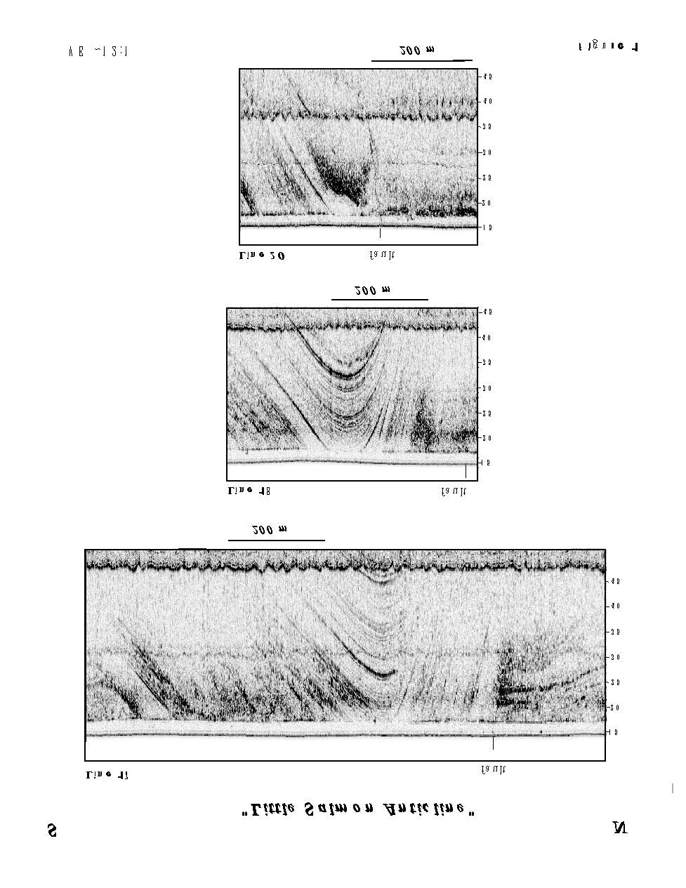
3 After overcoming initial equipment problems, our cruise was a success. We collected approximately 1050 km of dual frequency side-scan (100 & 500 khz) and high resolution Chirp data along the inner California shelf (Figures 1 and 2). The acquired sides-scan images provide data along the inner shelf that complement the EM1000 data collected along the California margin in 1995 by L. Mayer and others. This new data extends our swath coverage landward to the 20 m isobath and in some areas to the 8 m isobath. In addition to acquiring data offshore, we also mapped the structure, stratigraphy, and morphology in Humboldt Bay to determine if the paleochannels and fault structures mapped on the inner shelf extend landward. Data analysis is proceeding and the 100 khz side-scan mosaic will be combined with the EM1000 backscatter data from the region. RESULTS Numerous surficial failures were observed in the side-scan data on slopes averaging less than one degree. In addition to the failures, high and low reflectivity patches (blotchy seafloor) on the seafloor, and pock marks m in diameter were observed. The regions of blotchy seafloor and pock marks were often associated with high reflectivity clouds in the water column observed in the side-scan data between nadir and the first seafloor arrival as well as with high reflectivity regions in the Chirp subbottom data. Underwater video and recently acquired ROV data (October 1998) indicate that these high reflectivity clouds are caused by gas in the water column. The failures and blotchy seafloor appear to be spatially related to the Eel and Mad River subaqueous deltas, which consist of coarse-grained deposits and have an unexpectedly low backscatter amplitude. The intervening region between the subaqueous deltas is relatively devoid of pock marks and blotchy seafloor in the side-scan data, and is characterized by shore-perpendicular streaks of low backscatter imaged in both the 100 and 500 khz side-scan data. High frequency ( khz) chirp seismic data were collected concomitantly with the side-scan data across the shelf and routinely imaged ~30+ m into the subbottom. In the region between the subaqueous deltas, numerous subbottom reflectors at a variety of depths were consistently imaged (Figures 1 and 2). In fact, a pronounced anticline is imaged between the subaqueous deltas and appears to be the landward continuation of the Little Salmon Anticline observed offshore on the lower slope. The crest of the anticline is buried by approximately 3 meters of sand and in some areas a southward dipping fault appears to continue up into the overlying carapace (Figure 1). The style and nature of the anticline changes dramatically along strike; from being obscured by gas offshore (Figure 2), to being a text-book example of an anticline in shallower water. Preliminary analysis suggests that this fault/fold structure continues onshore and crosses Samoa Beach and northern Humboldt Bay and appears to extend under the City of Eureka. Moving away from the crest of the observed anticline (Figure 1) the overlying sedimentary succession thickens both toward the Mad River syncline and toward the Eel River Syncline (Figure 2). The sedimentary layers onlap the structural high indicating that the layers are thinning by nondeposition rather than by erosion. The thickness of the overlying carapace increases from approximately 3 m near the crest of the anticline to greater than 45 m near the axis of the Eel River syncline. Age dating and further mapping will provide new insights concerning the tectonic control on the long-term accumulation offshore California. The amplitude of the reflectors decreases markedly near both the Eel and Mad River subaqueous deltas. Across the subaqueous deltas themselves, there are no observed reflectors. In this region, only a very
4 diffuse scattering layer ~5 meters below the seafloor is observed as well as intermittent highly reflective 'bright' zones. On the basis of the pock marks and blotchy seafloor, subbottom acoustic character, and gas seeps, we propose that shallow gas may be an important contributor to failures observed on the subaqueous deltas. Paleochannels are also observed in the Chirp data offshore Somoa Beach just to the north of the Little Salmon Anticline. The paleochannels suggest that the mouth of Humboldt Bay was located farther north in the past or they may be recording the location of the antecedent Mad River. Further seismic correlation and research is required to understand the importance of the observed paleochannels. IMPACT/APPLICATION New images of the shallow fold and fault structures offshore Northern California will improve our understanding of the tectonic deformation and how it governs long-term accumulation along the margin. In addition, defining the distribution of fold and fault structures in the region might potentially help mitigate earthquake hazards. The paleochannels observed in the Chirp data suggest that the mouth of Humboldt Bay was located farther north in the past. These paleochannels may also be recording the location of antecedent rivers (e.g., Mad River). A better understanding of inlet and channel migration is the critical first step to deciphering preserved strata in shallow water regions. Finally, shallow gas release may be an important process contributing to failures observed on the subaqueous deltas. Earthquakes and excess pore-pressure caused by rapid sediment accumulation may be potential triggers of gas release which might explain the occurrence of failures on such low angle slopes. TRANSITIONS Results from our cruise concerning gas seep locations were used to collect gas samples along the Eel River margin by an ROV cruise conducted during late October, 1998 by Lisa Levin and Kevin Brown (SIO). Our new SUBSCAN system will also be used to conduct feasibility studies for biological acoustic imaging (T. Stanton, WHOI). The USGS is interested in using the new SUBSCAN to image other shallow water regions offshore California (e.g., San Francisco Bay) to define shallow fault zones. RELATED PROJECTS The goals of this project interface with the objectives of a number of ongoing and proposed research projects within the ONR STRATAFORM Initiative both on the east and west coast of the United States. Furthermore, by imaging shallow-water stratigraphy we will improve our understanding of processes that transfer sediment, sculpt the continental margin, and create stratigraphic sequences, insight that can be applied to other littoral zones throughout the world.
5 PUBLICATIONS N.W. Driscoll, D. L. Orange, J. Yun, L. Fonseca, and L. Mayer, High Resolution Side-Scan and Seismic Images of Landslides on the Northern California Continental Shelf. Abstr. EOS Transactions Fall Meeting.
6 Figure 1
7 Figure 2
Shelf And Slope Sediment Transport In Strataform
 Shelf And Slope Sediment Transport In Strataform David A. Cacchione Woods Hole Group 1167 Oddstad Drive Redwood City, MA 94063 phone: 650-298-0520 fax: 650-298-0523 email: dcacchione@whgrp.com Award #:
James A. Austin, Jr. phone: (512) fax: (512)
 fax: (512)") High-Resolution Seismic Surveying for Neogene-Quaternary Sequence Stratigraphy, Northern California Continental Shelf and Upper Slope, in Support of STRATAFORM Craig S. Fulthorpe University of Texas Institute
High-Resolution Seismic Surveying for Neogene-Quaternary Sequence Stratigraphy, Northern California Continental Shelf and Upper Slope, in Support of STRATAFORM Craig S. Fulthorpe University of Texas Institute
Award #: N AASERT Award #: N LONG-TERM GOALS
 HIGH-RESOLUTION SEISMIC SURVEYING FOR NEOGENE- QUATERNARY SEQUENCE STRATIGRAPHY, NORTHERN CALIFORNIA CONTINENTAL SHELF AND UPPER SLOPE, IN SUPPORT OF STRATAFORM Craig S. Fulthorpe and James A. Austin,
Strataform Plume Study
 LONG-TERM GOAL Strataform Plume Study James F. Lynch James D. Irish Woods Hole Oceanographic Institution Woods Hole, MA 543 phone: (58) 89-3 fax: (58) 457-94 e-mail: jlynch@whoi.edu phone: (58) 89-73 fax:
SW06 Shallow Water Acoustics Experiment Data Analysis
 DISTRIBUTION STATEMENT A: Approved for public release; distribution is unlimited. SW06 Shallow Water Acoustics Experiment Data Analysis James F. Lynch MS #12, Woods Hole Oceanographic Institution Woods
Sediment Flux and Trapping on the Skagit Tidal Flats
 Sediment Flux and Trapping on the Skagit Tidal Flats W. Rockwell Geyer Woods Hole Oceanographic Institution MS 11, Woods Hole, MA 02543 phone: 508-289-2868 fax: 508-457-2194 email: rgeyer@whoi.edu Peter
Satellite Observations of Surface Fronts, Currents and Winds in the Northeast South China Sea
 Satellite Observations of Surface Fronts, Currents and Winds in the Northeast South China Sea Michael J. Caruso Department of Physical Oceanography, MS #21 Woods Hole Oceanographic Institution Woods Hole,
Using a Near-Bed Sediment Flux Sensor to Measure Wave Formed Bedform Migrations and Formation Processes
 Using a Near-Bed Sediment Flux Sensor to Measure Wave Formed Bedform Migrations and Formation Processes Peter A. Traykovski Woods Hole Oceanographic Institution Woods Hole, MA 02543 1Tel.: (508) 289-2638,
Margin Morphodynamics: Debris Flows, Turbidity Currents and Experimental Margin Stratigraphy
 Margin Morphodynamics: Debris Flows, Turbidity Currents and Experimental Margin Stratigraphy Gary Parker St. Anthony Falls Laboratory University of Minnesota Mississippi River at 3 rd Ave. SE Minneapolis,
Closed-form and Numerical Reverberation and Propagation: Inclusion of Convergence Effects
 DISTRIBUTION STATEMENT A. Approved for public release; distribution is unlimited. Closed-form and Numerical Reverberation and Propagation: Inclusion of Convergence Effects Chris Harrison Centre for Marine
Determining the Stratification of Exchange Flows in Sea Straits
 Determining the Stratification of Exchange Flows in Sea Straits Lawrence J. Pratt Physical Oceanography Department, MS #21 Woods Hole Oceanographic Institution, Woods Hole, MA 02543 phone: (508) 289-2540
Award Number N
 Toward Linking Seabed Stratigraphy and Nested Seismic Datasets in STRATAFORM: Finalizing Plans for Long Coring and Synthesizing Existing Physical Property Data Dr. Clark R. Alexander Skidaway Institute
Marginal Sea - Open Ocean Exchange
 Marginal Sea - Open Ocean Exchange Michael A. Spall Mail Stop 21 Department of Physical Oceanography Woods Hole Oceanographic Institution Woods Hole, MA 02543-1541 phone: (508) 289-3342 fax: (508) 457-2181
Geophysical and Geological Reconnaissance for the ONR Geoclutter Program
 Geophysical and Geological Reconnaissance for the ONR Geoclutter Program James A. Austin, Jr., John A. Goff University of Texas Institute for Geophysics 4412 Spicewood Springs Rd., Bldg. 600 Austin, TX
An Examination of 3D Environmental Variability on Broadband Acoustic Propagation Near the Mid-Atlantic Bight
 An Examination of 3D Environmental Variability on Broadband Acoustic Propagation Near the Mid-Atlantic Bight Kevin B. Smith Code PH/Sk, Department of Physics Naval Postgraduate School Monterey, CA 93943
Understanding Near-Surface and In-cloud Turbulent Fluxes in the Coastal Stratocumulus-topped Boundary Layers
 Understanding Near-Surface and In-cloud Turbulent Fluxes in the Coastal Stratocumulus-topped Boundary Layers Qing Wang Meteorology Department, Naval Postgraduate School Monterey, CA 93943 Phone: (831)
Computer Simulation of Sand Ripple Growth and Migration.
 Computer Simulation of Sand Ripple Growth and Migration. Douglas J. Wilson OGI School of Environmental Science and Engineering at the Oregon Health and Sciences University 20000 N.W. Walker Road, Beaverton,
Nonlinear Internal Waves: Test of the Inverted Echo Sounder
 Nonlinear Internal Waves: Test of the Inverted Echo Sounder David M. Farmer Graduate School of Oceanography (educational) University of Rhode Island Narragansett, RI 02882 Phone: (401) 874-6222 fax (401)
Analysis of Mixing and Dynamics Associated with the Dissolution of Hurricane-Induced Cold Wakes
 DISTRIBUTION STATEMENT A: Approved for public release; distribution is unlimited. Analysis of Mixing and Dynamics Associated with the Dissolution of Hurricane-Induced Cold Wakes Carol Anne Clayson Dept.
Topographic Effects on Stratified Flows
 Topographic Effects on Stratified Flows Laurence Armi Institute of Geophysics and Planetary Physics Scripps Institution of Oceanography La Jolla, CA 92093-0225 phone: (858) 534-6843 fax: (858) 534-5332
Character and History of the Yangtze Mud Wedge, Fujian Province
 Character and History of the Yangtze Mud Wedge, Fujian Province John D. Milliman Virginia Institute of Marine Science, College of William and Mary, Gloucester Pt, VA 23062 phone: (804) 684-7112 fax: (804)
Coupled Ocean-Atmosphere Modeling of the Coastal Zone
 Coupled Ocean-Atmosphere Modeling of the Coastal Zone Eric D. Skyllingstad College of Oceanic and Atmospheric Sciences, Oregon State University 14 Ocean Admin. Bldg., Corvallis, OR 97331 Phone: (541) 737-5697
Coastal Mixing and Optics
 Coastal Mixing and Optics W. Scott Pegau College of Oceanic and Atmospheric Sciences Ocean. Admin. Bldg. 104 Oregon State University Corvallis, OR 97331-5503 Phone: (541) 737-5229 fax: (541) 737-2064 email:
ANALYSIS OF THE CAUSES AND CONSEQUENCES OF SUBMARINE SLOPE FAILURE
 ANALYSIS OF THE CAUSES AND CONSEQUENCES OF SUBMARINE SLOPE FAILURE Lincoln F. Pratson Institute of Arctic and Alpine Research University of Colorado, Boulder, CO, 80309-0450 phone: (303) 492-6752, fax:
Seabed Variability and its Influence on Acoustic Prediction Uncertainty
 Seabed Variability and its Influence on Acoustic Prediction Uncertainty Lincoln F. Pratson Earth & Ocean Sciences Duke University Durham, NC 27708 phone: (919) 681-8077 fax: (919) 684-5833 email: lincoln.pratson@duke.edu
Sediment Dispersal from the Apennine Rivers
 Sediment Dispersal from the Apennine Rivers Gail C. Kineke Dept of Geology and Geophysics Boston College Chestnut Hill, MA 02467 phone: 617-552-3655 fax: 617-552-2462 email:kinekeg@bc.edu Award # N00014-02-1-0234
Modeling the Impact of Extreme Events on Margin Sedimentation
 Modeling the Impact of Extreme Events on Margin Sedimentation Jasim Imran Department of Civil and Environmental Engineering, University of South Carolina, 3 Main Street, Columbia, SC 2928. phone: (83)
Report Documentation Page
 Modeling Swashzone Fluid Velocities Britt Raubenheimer Woods Hole Oceanographic Institution 266 Woods Hole Rd, MS # 12 Woods Hole, MA 02543 phone (508) 289-3427, fax (508) 457-2194, email britt@whoi.edu
Analysis of Subsurface Velocity Data from the Arctic Ocean
 Analysis of Subsurface Velocity Data from the Arctic Ocean Albert J. Plueddemann 202A Clark Lab, MS-29 Woods Hole Oceanographic Institution Woods Hole, MA 02541-1541 ph: (508) 289-2789, fax: (508) 457-2163
Sediment Acoustics. Award #: N Thrust Category: High-Frequency LONG-TERM GOAL
 Sediment Acoustics Robert D. Stoll Lamont-Doherty Earth Observatory of Columbia University Palisades, New York 10964 phone: (845) 365 8392 fax: (845) 365 8179 email: stoll@ldeo.columbia.edu Award #: N00014-94-1-0258
Mine Burial Studies with a Large Oscillating Water-Sediment Tunnel (LOWST)
") Mine Burial Studies with a Large Oscillating Water-Sediment Tunnel (LOWST) Marcelo H. Garcia Department of Civil and Environmental Engineering University of Illinois at Urbana-Champaign 205 North Mathews
Mine Burial Studies with a Large Oscillating Water-Sediment Tunnel (LOWST) Marcelo H. Garcia Department of Civil and Environmental Engineering University of Illinois at Urbana-Champaign 205 North Mathews
Contract No. N C0123
 Particle Size Distribution and Optical Volume Scattering Function in the Mid and Upper Water Column of Optically Deep Coastal Regions: Transport from the Bottom Boundary Layer Y. C. Agrawal Sequoia Scientific,
Internal Waves and Mixing in the Aegean Sea
 Internal Waves and Mixing in the Aegean Sea PI: Michael Gregg Applied Physics Lab/Univ. Washington, Seattle, WA 98105 phone: (206) 543-1353 fax: (206) 543-6785 email: gregg@apl.washington.edu CO-PI: Matthew
Testing Turbulence Closure Models Against Oceanic Turbulence Measurements
 Testing Turbulence Closure Models Against Oceanic Turbulence Measurements J. H. Trowbridge Woods Hole Oceanographic Institution Woods Hole, MA 02543 phone: 508-289-2296 fax: 508-457-2194 e-mail: jtrowbridge@whoi.edu
Ocean Acoustics Turbulence Study
 Ocean Acoustics Turbulence Study PI John Oeschger Coastal Systems Station 6703 West Highway 98 Panama City, FL 32407 phone: (850) 230-7054 fax: (850) 234-4886 email: OeschgerJW@ncsc.navy.mil CO-PI Louis
Use of Wijsman's Theorem for the Ratio of Maximal Invariant Densities in Signal Detection Applications
 Use of Wijsman's Theorem for the Ratio of Maximal Invariant Densities in Signal Detection Applications Joseph R. Gabriel Naval Undersea Warfare Center Newport, Rl 02841 Steven M. Kay University of Rhode
High Resolution Surface Characterization from Marine Radar Measurements
 DISTRIBUTION STATEMENT A: Distribution approved for public release; distribution is unlimited High Resolution Surface Characterization from Marine Radar Measurements Hans C. Graber CSTARS - University
Swash Zone Dynamics: Modeling and Data Analysis
 Swash Zone Dynamics: Modeling and Data Analysis Donald N. Slinn Department of Civil and Coastal Engineering University of Florida Gainesville, FL 32611-6590 phone: (352) 392-1436 x 1431 fax: (352) 392-3466
FIELD MEASUREMENTS OF SEDIMENT TRANSPORT PROCESSES IN STRATAFORM
 FIELD MEASUREMENTS OF SEDIMENT TRANSPORT PROCESSES IN STRATAFORM LONG-TERM GOALS David A. Cacchione U.S. Geological Survey 345 Middlefield Road, MS-999 Menlo Park, CA 94025 phone: 415-329-5481 fax: 415-329-5411
Flocculation, Optics and Turbulence in the Community Sediment Transport Model System: Application of OASIS Results
 DISTRIBUTION STATEMENT A: Approved for public release; distribution is unlimited. Flocculation, Optics and Turbulence in the Community Sediment Transport Model System: Application of OASIS Results Emmanuel
Modeling the Formation and Offshore Transport of Dense Water from High-Latitude Coastal Polynyas
 Modeling the Formation and Offshore Transport of Dense Water from High-Latitude Coastal Polynyas David C. Chapman Woods Hole Oceanographic Institution Woods Hole, MA 02543 phone: (508) 289-2792 fax: (508)
Report Documentation Page
 Report Documentation Page Form Approved OMB No. 0704-0188 Public reporting burden for the collection of information is estimated to average 1 hour per response, including the time for reviewing instructions,
Scattering of Internal Gravity Waves at Finite Topography
 Scattering of Internal Gravity Waves at Finite Topography Peter Muller University of Hawaii Department of Oceanography 1000 Pope Road, MSB 429 Honolulu, HI 96822 phone: (808)956-8081 fax: (808)956-9164
Sediment Acoustics LONG-TERM GOAL
 Sediment Acoustics Robert D. Stoll Lamont-Doherty Earth Observatory of Columbia University Palisades, New York 10964 phone: (914) 365 8392 fax: (914) 365 8179 email: rdstoll@worldnet.att.net Award #: N00014-94-1-0258
Shallow Water Fluctuations and Communications
 Shallow Water Fluctuations and Communications H.C. Song Marine Physical Laboratory Scripps Institution of oceanography La Jolla, CA 92093-0238 phone: (858) 534-0954 fax: (858) 534-7641 email: hcsong@mpl.ucsd.edu
Models of Marginal Seas Partially Enclosed by Islands
 Models of Marginal Seas Partially Enclosed by Islands Roxana C. Wajsowicz Dept. of Meteorology University of Maryland 3433 Computer and Space Science Building College Park, MD 20852 Phone: (301) 405-5396
Inversion for Geoacoustic Model Parameters in Range-Dependent Shallow Water Environments
 DISTRIBUTION STATEMENT A: Approved for public release; distribution is unlimited. Inversion for Geoacoustic Model Parameters in Range-Dependent Shallow Water Environments N. Ross Chapman School of Earth
Seafloor Reconnaissance Surveys and Change Monitoring Using a Small AUV and a Small ROV
 Seafloor Reconnaissance Surveys and Change Monitoring Using a Small AUV and a Small ROV Grant Number: N00014-05-1-0665 Acquisition of a REMUS Autonomous Underwater Vehicle and a Small ROV for the University
EFFECTS OF LOCAL METEOROLOGICAL VARIABILITY ON SURFACE AND SUBSURFACE SEISMIC-ACOUSTIC SIGNALS
 EFFECTS OF LOCAL METEOROLOGICAL VARIABILITY ON SURFACE AND SUBSURFACE SEISMIC-ACOUSTIC SIGNALS Jason R. McKenna and Mihan H. McKenna U.S. Army Engineer Research & Development Center, Vicksburg, MS 39180
Analysis of South China Sea Shelf and Basin Acoustic Transmission Data
 DISTRIBUTION STATEMENT A: Approved for public release; distribution is unlimited. Analysis of South China Sea Shelf and Basin Acoustic Transmission Data Ching-Sang Chiu Department of Oceanography Naval
Estimation of Vertical Distributions of Water Vapor from Spaceborne Observations of Scattered Sunlight
 Estimation of Vertical Distributions of Water Vapor from Spaceborne Observations of Scattered Sunlight Dale P. Winebrenner Applied Physics Laboratory, Box 355640 University of Washington Seattle, WA 98195
Range-Dependent Acoustic Propagation in Shallow Water with Elastic Bottom Effects
 DISTRIBUTION STATEMENT A. Approved for public release; distribution is unlimited. Range-Dependent Acoustic Propagation in Shallow Water with Elastic Bottom Effects Robert I. Odom Applied Physics Laboratory
Estimation of Vertical Distributions of Water Vapor and Aerosols from Spaceborne Observations of Scattered Sunlight
 Estimation of Vertical Distributions of Water Vapor and Aerosols from Spaceborne Observations of Scattered Sunlight Dale P. Winebrenner Polar Science Center/Applied Physics Laboratory University of Washington
LAGRANGIAN MEASUREMENTS OF EDDY CHARACTERISTICS IN THE CALIFORNIA CURRENT
 LAGRANGIAN MEASUREMENTS OF EDDY CHARACTERISTICS IN THE CALIFORNIA CURRENT Robert C. Beardsley, Kenneth H. Brink, Richard Limeburner Clark Laboratory, Mail Stop 21 Woods Hole Oceanographic Institution Woods
The Mechanics of Bubble Growth and Rise in Sediments
 The Mechanics of Bubble Growth and Rise in Sediments PI: Bernard P. Boudreau Department of Oceanography Dalhousie University Halifax, Nova Scotia B3H 4J1, Canada phone: (902) 494-8895 fax: (902) 494-3877
A 1/10th Degree Global Ocean Simulation Using the Parallel Ocean Program
 A 1/10th Degree Global Ocean Simulation Using the Parallel Ocean Program Mathew E Maltrud Fluid Dynamics Group MS B216 Los Alamos National Laboratory Los Alamos, NM 87545 phone: (505) 667-9097 fax: (505)
Crowd Behavior Modeling in COMBAT XXI
 Crowd Behavior Modeling in COMBAT XXI Imre Balogh MOVES Research Associate Professor ilbalogh@nps.edu July 2010 831-656-7582 http://movesinstitute.org Report Documentation Page Form Approved OMB No. 0704-0188
Modeling of Coastal Ocean Flow Fields
 Modeling of Coastal Ocean Flow Fields John S. Allen College of Oceanic and Atmospheric Sciences Oregon State University 104 Ocean Admin Building Corvallis, OR 97331-5503 phone: (541) 737-2928 fax: (541)
INTERACTION AND REMOTE SENSING OF SURFACE WAVES AND TURBULENCE
 INTERACTION AND REMOTE SENSING OF SURFACE WAVES AND TURBULENCE W. Kendall Melville Scripps Institution of Oceanography University of California, San Diego La Jolla, CA 9293-23 phone: (69) 534-478, fax:
Characterization of Caribbean Meso-Scale Eddies
 Characterization of Caribbean Meso-Scale Eddies Jose M. Lopez P.O. Box 9013 Mayaguez, Puerto Rico 00681-9013 phone: (787) 834-7620 fax: (787) 834-8025 email: jlopez@uprm.edu phone: (787) 899-2049 Jorge
The Impact of River Basin Size on the Distribution and Character of Preserved Strata: A Comparison of the Po and Apennine Systems
 The Impact of River Basin Size on the Distribution and Character of Preserved Strata: A Comparison of the Po and Apennine Systems Robert A. Wheatcroft College of Oceanic & Atmospheric Sciences Oregon State
Internal Tide Generation in the Indonesian Seas
 Internal Tide Generation in the Indonesian Seas Amy Ffield Earth and Space Research, 290 Clausland Mountain Road, Upper Grandview, NY 10960 Phone: (845) 353-1733 Fax: (845) 353-1733 Email: ffield@esr.org
Understanding Near-Surface and In-Cloud Turbulent Fluxes in the Coastal Stratocumulus-Topped Boundary Layers
 Understanding Near-Surface and In-Cloud Turbulent Fluxes in the Coastal Stratocumulus-Topped Boundary Layers Qing Wang Meteorology Department, Naval Postgraduate School Monterey, CA 93943 Phone: (831)
Advanced Analysis and Synthesis of the Eastern Boundary Current ARI Data Set
 Advanced Analysis and Synthesis of the Eastern Boundary Current ARI Data Set Steven R. Ramp Department of Oceanography, Code OC/Ra Naval Postgraduate School Monterey, CA 93943-5122 phone: (831) 656-2201
Coastal Ocean Circulation Experiment off Senegal (COCES)
") DISTRIBUTION STATEMENT A: Approved for public release; distribution is unlimited. Coastal Ocean Circulation Experiment off Senegal (COCES) Pierre-Marie Poulain Istituto Nazionale di Oceanografia e di Geofisica
DISTRIBUTION STATEMENT A: Approved for public release; distribution is unlimited. Coastal Ocean Circulation Experiment off Senegal (COCES) Pierre-Marie Poulain Istituto Nazionale di Oceanografia e di Geofisica
FRACTAL CONCEPTS AND THE ANALYSIS OF ATMOSPHERIC PROCESSES
 1 FRACTAL CONCEPTS AND THE ANALYSIS OF ATMOSPHERIC PROCESSES Robert L. Street Environmental Fluid Mechanics Laboratory Department of Civil Engineering Stanford University Stanford, CA 94305-4020 650-723-4969;
Sensitivity of West Florida Shelf Simulations to Initial and Boundary Conditions Provided by HYCOM Data-Assimilative Ocean Hindcasts
 Sensitivity of West Florida Shelf Simulations to Initial and Boundary Conditions Provided by HYCOM Data-Assimilative Ocean Hindcasts George Halliwell, MPO/RSMAS, University of Miami Alexander Barth, University
Support for Sea Trials of Active Heave Compensation on the GLAD800 Drilling Rig
 Support for Sea Trials of Active Heave Compensation on the GLAD800 Drilling Rig Dennis L. Nielson University of Utah, Civil and Environmental Engineering 122 S. Central Campus Dr., EMRO 209, Salt Lake
The Sediment Budget Calculator: A Webtool to Develop a Family of Viable Inlet and Adjacent Beach Sediment Budget Solutions
 The Sediment Budget Calculator: A Webtool to Develop a Family of Viable Inlet and Adjacent Beach Sediment Budget Solutions by Julie Dean Rosati, Charles A. Sumner, and Derek A. Wilson PURPOSE: This Coastal
Award # N LONG TERM GOALS
 Non-Invasive Characterization Of Small-Scale Patterns Of Benthic Biogenic Structure By Ultrasound: Infaunal Dynamics And Sediment Structure, And Effect Of Sediment Disturbance Donald G. Webb Graduate School
COASTAL MIXING AND OPTICS
 COASTAL MIXING AND OPTICS J. Ronald V. Zaneveld College of Oceanic and Atmospheric Sciences Ocean. Admin. Bldg. 104 Oregon State University Corvallis, OR 97331-5503 Phone: (541) 737-3571 fax: (541) 737-2064
Real-Time Environmental Information Network and Analysis System (REINAS)
") Calhoun: The NPS Institutional Archive Faculty and Researcher Publications Faculty and Researcher Publications 1998-09 Real-Time Environmental Information Network and Analysis System (REINAS) Nuss, Wendell
Calhoun: The NPS Institutional Archive Faculty and Researcher Publications Faculty and Researcher Publications 1998-09 Real-Time Environmental Information Network and Analysis System (REINAS) Nuss, Wendell
UUV Operations to Characterize Circulation and Morphology of Tidal Flats
 UUV Operations to Characterize Circulation and Morphology of Tidal Flats Mark A. Moline Center for Coastal Marine Sciences and Biological Sciences Department California Polytechnic State University 1 Grand
Neogene Stratigraphic Development of the Arabian (Persian) Gulf
 Gulf") Neogene Stratigraphic Development of the Arabian (Persian) Gulf Stephen A. Swift and David A. Ross Dept. of Geology and Geophysics Woods Hole Oceanographic Institution Woods Hole, MA 02543 Swift: ph: 508-289-2626
Neogene Stratigraphic Development of the Arabian (Persian) Gulf Stephen A. Swift and David A. Ross Dept. of Geology and Geophysics Woods Hole Oceanographic Institution Woods Hole, MA 02543 Swift: ph: 508-289-2626
Attribution Concepts for Sub-meter Resolution Ground Physics Models
 Attribution Concepts for Sub-meter Resolution Ground Physics Models 76 th MORS Symposium US Coast Guard Academy Approved for public release distribution. 2 Report Documentation Page Form Approved OMB No.
Utilizing Autonomous Underwater Vehicles for Seafloor Mapping, Target Identification, and Predictive Model Testing
 Utilizing Autonomous Underwater Vehicles for Seafloor Mapping, Target Identification, and Predictive Model Testing Dawn Lavoie Naval Research Laboratory Stennis Space Center, MS 39529-5004 phone: (228)688-4659
System Reliability Simulation and Optimization by Component Reliability Allocation
 System Reliability Simulation and Optimization by Component Reliability Allocation Zissimos P. Mourelatos Professor and Head Mechanical Engineering Department Oakland University Rochester MI 48309 Report
DISTRIBUTION STATEMENT A. Approved for public release; distribution is unlimited.
 DISTRIBUTION STATEMENT A. Approved for public release; distribution is unlimited. High-Resolution Hydrographic Surveys near the Shelfbreak in the East China Sea: Joint Studies with National Taiwan University
DISTRIBUTION STATEMENT A. Approved for public release; distribution is unlimited.
 DISTRIBUTION STATEMENT A. Approved for public release; distribution is unlimited. The Probabilistic Nature of Extended-Range Predictions of Tropical Cyclone Activity and Tracks as a Factor in Forecasts
Broadband matched-field source localization in the East China Sea*
 Broadband matched-field source localization in the East China Sea* Renhe Zhang Zhenglin Li Jin Yan Zhaohui Peng Fenghua Li National Laboratory of Acoustics, Institute of Acoustics, Chinese Academy of Sciences,
Predicting Tropical Cyclone Formation and Structure Change
 Predicting Tropical Cyclone Formation and Structure Change Patrick A. Harr Department of Meteorology Naval Postgraduate School Monterey, CA 93943-5114 Telephone: (831)656-3787 FAX:(831)656-3061 email:
Using Static and Dynamic Penetrometers to Measure Sea Bed Properties
 Using Static and Dynamic Penetrometers to Measure Sea Bed Properties Robert D. Stoll Lamont-Doherty Earth Observatory of Columbia University, Palisades, N. Y. 10964 phone: (845) 365 8392 fax: (845) 365
Experimental and Theoretical Studies of Ice-Albedo Feedback Processes in the Arctic Basin
 LONG TERM GOALS Experimental and Theoretical Studies of Ice-Albedo Feedback Processes in the Arctic Basin D.K. Perovich J.A. Richter-Menge W.B. Tucker III M. Sturm U. S. Army Cold Regions Research and
Acoustic Scattering Classification of Zooplankton and Microstructure
 Acoustic Scattering Classification of Zooplankton and Microstructure Timothy K. Stanton Department of Applied Ocean Physics and Engineering Woods Hole Oceanographic Institution Woods Hole, MA 02543 phone
Super-Parameterization of Boundary Layer Roll Vortices in Tropical Cyclone Models
 DISTRIBUTION STATEMENT A. Approved for public release; distribution is unlimited. Super-Parameterization of Boundary Layer Roll Vortices in Tropical Cyclone Models PI Isaac Ginis Graduate School of Oceanography
Using Dye to Study Lateral Mixing in the Ocean: 100 m to 1 km
 DISTRIBUTION STATEMENT A. Approved for public release; distribution is unlimited. Using Dye to Study Lateral Mixing in the Ocean: 100 m to 1 km Murray D. Levine Oregon State University College of Earth,
Grant Number: N IP To compare obtained theoretical results with NPAL experimental data.
 Coherence of Low-Frequency Sound Signals Propagating through a Fluctuating Ocean: Analysis and Theoretical Interpretation of 2004 NPAL Experimental Data Alexander G. Voronovich NOAA/ESRL, PSD4, 325 Broadway,
Coastal Mixing. Eric A. D Asaro APL/UW 1013 NE 40 th Str, Seattle, WA phone: (206) fax: (206)
 fax: (206)") Coastal Mixing Eric A. D Asaro APL/UW 1013 NE 40 th Str, Seattle, WA 98105 phone: (206) 685-2982 fax: (206) 543-6785 email: dasaro@apl.washington.edu Ren Chieh Lien APL/UW 1013 NE 40 th Str, Seattle, WA
Coastal Mixing Eric A. D Asaro APL/UW 1013 NE 40 th Str, Seattle, WA 98105 phone: (206) 685-2982 fax: (206) 543-6785 email: dasaro@apl.washington.edu Ren Chieh Lien APL/UW 1013 NE 40 th Str, Seattle, WA
Comparative Analysis of Flood Routing Methods
 US Army Corps of Engineers Hydrologic Engineering Center Comparative Analysis of Flood Routing Methods September 1980 Approved for Public Release. Distribution Unlimited. RD-24 REPORT DOCUMENTATION PAGE
Long-Range Underwater Sound Propagation: Environmental Variability, Signal Stability and Signal Coherence
 DISTRIBUTION STATEMENT A. Approved for public release; distribution is unlimited. Long-Range Underwater Sound Propagation: Environmental Variability, Signal Stability and Signal Coherence Michael G. Brown
P. Kestener and A. Arneodo. Laboratoire de Physique Ecole Normale Supérieure de Lyon 46, allée d Italie Lyon cedex 07, FRANCE
 A wavelet-based generalization of the multifractal formalism from scalar to vector valued d- dimensional random fields : from theoretical concepts to experimental applications P. Kestener and A. Arneodo
Formation of Crenulated Clinoforms on Continental Shelves
 Formation of Crenulated Clinoforms on Continental Shelves P. Puig Institut de Ciències del Mar (CSIC) Passeig Marítim de la Barceloneta, 37-49 Barcelona 83, Spain phone: +34 93 23 9518 fax: +34 93 23 9555
Dynamics of Boundary Currents and Marginal Seas
 Dynamics of Boundary Currents and Marginal Seas W. E. Johns University of Miami, RSMAS/MPO 4600 Rickenbacker Causeway, Miami, Florida 33149-1098 Phone (305)361-4054; fax: (305)361-4696; email: wjohns@rsmas.miami.edu
DIRECTIONAL WAVE SPECTRA USING NORMAL SPREADING FUNCTION
 CETN-I-6 3185 DIRECTIONAL WAVE SPECTRA USING NORMAL SPREADING FUNCTION PURPOSE : To present a parameterized model of a directional spectrum of the sea surface using an energy spectrum and a value for the
Upper Ocean Measurements of Water Masses and Circulation in the Japan Sea
 Upper Ocean Measurements of Water Masses and Circulation in the Japan Sea Stephen C. Riser School of Oceanography, University of Washington, Seattle, Washington 98195 USA Phone: (206) 543-1187 Fax: (206)
Seabed Geoacoustic Structure at the Meso-Scale
 DISTRIBUTION STATEMENT A. Approved for public release; distribution is unlimited. Seabed Geoacoustic Structure at the Meso-Scale Charles W. Holland The Pennsylvania State University Applied Research Laboratory
Improved Parameterizations Of Nonlinear Four Wave Interactions For Application In Operational Wave Prediction Models
 Improved Parameterizations Of Nonlinear Four Wave Interactions For Application In Operational Wave Prediction Models Gerbrant Ph. van Vledder ALKYON Hydraulic Consultancy & Research P.O.Box 248, 8300 AD
Influences of Asymmetric Flow Features on Hurricane Evolution
 Influences of Asymmetric Flow Features on Hurricane Evolution Lloyd J. Shapiro Meteorological Institute University of Munich Theresienstr. 37, 80333 Munich, Germany phone +49 (89) 2180-4327 fax +49 (89)
PIPS 3.0. Pamela G. Posey NRL Code 7322 Stennis Space Center, MS Phone: Fax:
 PIPS 3.0 Ruth H. Preller Naval Research Laboratory, Code 7322 Stennis Space Center, MS 39529 phone: (228) 688-5444 fax: (228)688-4759 email: preller@nrlssc.navy.mil Pamela G. Posey NRL Code 7322 Stennis
Coastal Engineering Technical Note
 Coastal Engineering Technical Note CETN I-48 (12/91) Evaluation and Application of the Wave Information Study for the Gulf of Mexico INTRODUCTION The Wave Information Study (WIS) for the Gulf of Mexico